
Articles | Volume 19, issue 4
https://doi.org/10.5194/hess-19-2101-2015
© Author(s) 2015. This work is distributed under
the Creative Commons Attribution 3.0 License.
the Creative Commons Attribution 3.0 License.
https://doi.org/10.5194/hess-19-2101-2015
© Author(s) 2015. This work is distributed under
the Creative Commons Attribution 3.0 License.
the Creative Commons Attribution 3.0 License.
Research article
| 
30 Apr 2015
Research article |
| 30 Apr 2015
Virtual laboratories: new opportunities for collaborative water science
Department DICAM, University of Bologna, Bologna, Italy
B. Arheimer
Hydrology Research Section, Swedish Meteorological and Hydrological Institute (SMHI), Norrköping, Sweden
E. Baratti
Department DICAM, University of Bologna, Bologna, Italy
G. Blöschl
Institute of Hydraulic Engineering and Water Resources Management, Vienna University of Technology, Vienna, Austria
R. Capell
Hydrology Research Section, Swedish Meteorological and Hydrological Institute (SMHI), Norrköping, Sweden
A. Castellarin
Department DICAM, University of Bologna, Bologna, Italy
J. Freer
School of Geographical Sciences, University of Bristol, Bristol, UK
D. Han
Department of Civil Engineering, University of Bristol, Bristol, UK
M. Hrachowitz
Water Resources Section, Faculty of Civil Engineering and Geosciences, Delft University of Technology, Delft, the Netherlands
Y. Hundecha
Hydrology Research Section, Swedish Meteorological and Hydrological Institute (SMHI), Norrköping, Sweden
C. Hutton
Department of Civil Engineering, University of Bristol, Bristol, UK
School of Geographical Sciences, University of Bristol, Bristol, UK
G. Lindström
Hydrology Research Section, Swedish Meteorological and Hydrological Institute (SMHI), Norrköping, Sweden
A. Montanari
Department DICAM, University of Bologna, Bologna, Italy
R. Nijzink
Water Resources Section, Faculty of Civil Engineering and Geosciences, Delft University of Technology, Delft, the Netherlands
J. Parajka
Institute of Hydraulic Engineering and Water Resources Management, Vienna University of Technology, Vienna, Austria
Department DICAM, University of Bologna, Bologna, Italy
A. Viglione
Institute of Hydraulic Engineering and Water Resources Management, Vienna University of Technology, Vienna, Austria
T. Wagener
Department of Civil Engineering, University of Bristol, Bristol, UK
Cabot Institute, University of Bristol, Bristol, UK
Related authors
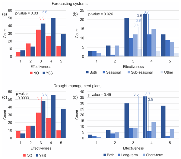
Riccardo Biella, Anastasiya Shyrokaya, Ilias Pechlivanidis, Daniela Cid, Maria Carmen Llasat, Faranak Tootoonchi, Marthe Wens, Marleen Lam, Elin Stenfors, Samuel Sutanto, Elena Ridolfi, Serena Ceola, Pedro Alencar, Giuliano Di Baldassarre, Monica Ionita, Mariana Madruga de Brito, Scott J. McGrane, Benedetta Moccia, Viorica Nagavciuc, Fabio Russo, Svitlana Krakovska, Andrijana Todorovic, Patricia Trambauer, Raffaele Vignola, and Claudia Teutschbein
Nat. Hazards Earth Syst. Sci., 26, 955–979, https://doi.org/10.5194/nhess-26-955-2026, https://doi.org/10.5194/nhess-26-955-2026, 2026
Short summary
Short summary
This research by the Drought in the Anthropocene (DitA) network highlights the crucial role of forecasting systems and Drought Management Plans in European drought risk management. Based on a survey of water managers during the 2022 European drought, it underscores the impact of preparedness on response and the evolution of drought management strategies across the continent, showing how organisations with preparedness measures in place responded faster and more effectively.
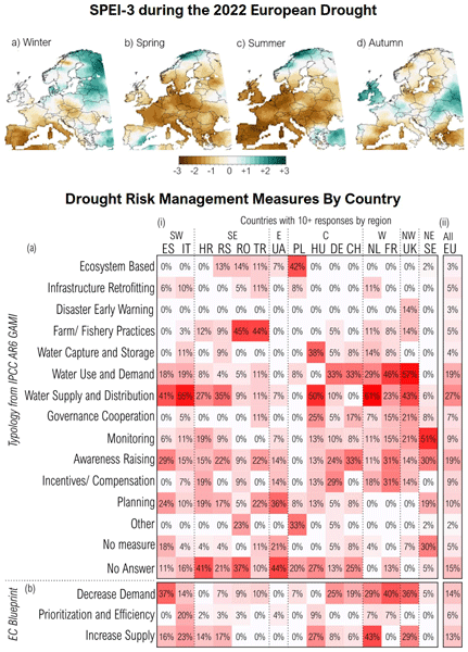
Riccardo Biella, Anastasiya Shyrokaya, Monica Ionita, Raffaele Vignola, Samuel J. Sutanto, Andrijana Todorovic, Claudia Teutschbein, Daniela Cid, Maria Carmen Llasat, Pedro Alencar, Alessia Matanó, Elena Ridolfi, Benedetta Moccia, Ilias Pechlivanidis, Anne van Loon, Doris E. Wendt, Elin Stenfors, Fabio Russo, Jean-Philippe Vidal, Lucy Barker, Mariana Madruga de Brito, Marleen Lam, Monika Bláhová, Patricia Trambauer, Raed Hamed, Scott J. McGrane, Serena Ceola, Sigrid J. Bakke, Svitlana Krakovska, Viorica Nagavciuc, Faranak Tootoonchi, Giuliano Di Baldassarre, Sandra Hauswirth, Shreedhar Maskey, Svitlana Zubkovych, Marthe Wens, and Lena M. Tallaksen
Nat. Hazards Earth Syst. Sci., 25, 4475–4501, https://doi.org/10.5194/nhess-25-4475-2025, https://doi.org/10.5194/nhess-25-4475-2025, 2025
Short summary
Short summary
The DitA (Drought in the Anthropocene) network's study on the 2022 European drought reveals growing risks, varied impacts, and fragmented, short-term management. Based on a survey of water managers, it explores risk, impacts, strategies, and their evolution. While challenges persist, signs of improvement show readiness for change. The authors call for a European Drought Directive to unify and guide future drought risk management.

Adrián Flores Orozco, Jakob Gallistl, Benjamin S. Gilfedder, Timea Katona, Sven Frei, Peter Strauss, and Gunter Blöschl
Biogeosciences, 23, 6287–6297, https://doi.org/10.5194/bg-23-6287-2026, https://doi.org/10.5194/bg-23-6287-2026, 2026
Short summary
Short summary
Understanding the role of soil in the storage of organic carbon is critical for a large number of environmental processes. Current practices rely on the drilling and analysis of samples, which is expensive, time consuming and destructive. Here we present a technique able to map soil organic carbon variability using measurements of the electrical properties of the subsurface without drilling. Our results advance soil management strategies to enhance carbon sequestration and storage.
Peter Berg, Denica Bozhinova, Yiheng Du, Yeshewatesfa Hundecha, Tobias Lagander, Ursula McKnight, Lisanne Nauta, Spyridon Paparrizos, Ilias Pechlivanidis, and Wei Yang
Earth Syst. Sci. Data Discuss., https://doi.org/10.5194/essd-2026-604, https://doi.org/10.5194/essd-2026-604, 2026
Preprint under review for ESSD
Short summary
Short summary
We developed and evaluated a Europe-wide service that provides monthly updates on expected river flow, runoff, snow storage and soil moisture for up to six months ahead. By combining several hydrological models with seasonal forecasts and testing them against historical data, we found that these forecasts can provide useful guidance for long-term planning. The freely available service can help improve water management, reduce risks and support adaptation.
Muhammad Ibrahim, Markus Hrachowitz, Miriam Coenders-Gerrits, and Ruud van der Ent
EGUsphere, https://doi.org/10.5194/egusphere-2026-4226, https://doi.org/10.5194/egusphere-2026-4226, 2026
This preprint is open for discussion and under review for Hydrology and Earth System Sciences (HESS).
Short summary
Short summary
Root zone storage capacity is an important parameter in hydrological and land-surface models and is often estimated using the memory method rather than through model calibration. We evaluated the uncertainty associated with this widely used method across thousands of catchments worldwide. Our results show that uncertainty varies systematically with climate, while memory method estimates remain in close agreement with calibrated values, supporting the commonly used 20-year return period.
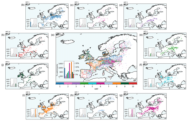
Julia M. Rudlang, Thiago V. M. do Nascimento, Ruud van der Ent, Fabrizio Fenicia, and Markus Hrachowitz
Hydrol. Earth Syst. Sci., 30, 4481–4508, https://doi.org/10.5194/hess-30-4481-2026, https://doi.org/10.5194/hess-30-4481-2026, 2026
Short summary
Short summary
River flow (streamflow) behaviour varies across Europe and is shaped by climate and landscape. Using data from more than 7000 European catchments, we identified 10 hydrological response types based on flow magnitude, timing, and seasonality. At the continental scale, streamflow behaviour is mainly driven by climate, but landscape features are equally or more influential in several regions. These results show that streamflow behaviour emerges from the combined effects of climate and landscape.
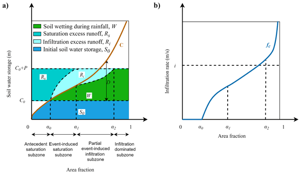
Yuanqi Hong, Guta Wakbulcho Abeshu, Hong-Yi Li, Dingbao Wang, Mengqi Zhao, Thomas Wild, Günter Blöschl, and L. Ruby Leung
Hydrol. Earth Syst. Sci., 30, 4293–4303, https://doi.org/10.5194/hess-30-4293-2026, https://doi.org/10.5194/hess-30-4293-2026, 2026
Short summary
Short summary
Rain runs off in two main ways: saturation excess when soil is full, and infiltration excess when rain exceeds infiltration. They often occur simultaneously in a watershed, but most models treat them separately. We introduce a new theory that captures both processes within a single framework, tracking their shift over space and time. Tested over 181 U.S. watersheds, the theory well predicts streamflow in most watersheds and improves understanding of runoff under diverse climates.
Jürgen Komma, Peter Valent, Miriam Bertola, Juraj Parajka, Klaus Haslinger, Benedikt Bica, Georg Pistotnik, Korbinian Breinl, Gabriele Müller, Lovrenc Pavlin, Bianca Kahl, Achim Naderer, and Günter Blöschl
Hydrol. Earth Syst. Sci., 30, 4075–4093, https://doi.org/10.5194/hess-30-4075-2026, https://doi.org/10.5194/hess-30-4075-2026, 2026
Short summary
Short summary
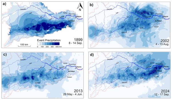
In September 2024 an exceptional flood hit the Austrian Danube Basin, the largest in parts of Lower Austria since records began. Using weather and river data, we compare this event with historic floods from 1899, 2002 and 2013. The 2024 flood was driven by a slow-moving rainstorm and saturated soils, causing record flows at smaller rivers. The study shows a shift toward more localized, intense floods, highlighting the need for adaptive flood-risk management in a warming climate.
Simon P. Heselschwerdt, Thorsten Wagener, Lan Wang-Erlandsson, Anna M. Ukkola, Yannis Markonis, Yuting Yang, and Peter Greve
Earth Syst. Dynam., 17, 811–827, https://doi.org/10.5194/esd-17-811-2026, https://doi.org/10.5194/esd-17-811-2026, 2026
Short summary
Short summary
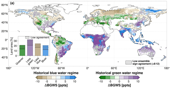
Precipitation on land is split into different pathways, contributing to runoff (blue water) or to plant water use (green water). Climate change alters this balance and shapes how future precipitation is divided. We use Earth system models to study these changes and their controls. We find that stronger extreme five-day precipitation is the main control and routes more future precipitation into blue water, even where average precipitation decreases, with implications for freshwater availability.
Qidong Fang, Mostaquimur Rahman, Thorsten Wagener, and Francesca Pianosi
EGUsphere, https://doi.org/10.5194/egusphere-2026-3267, https://doi.org/10.5194/egusphere-2026-3267, 2026
This preprint is open for discussion and under review for Hydrology and Earth System Sciences (HESS).
Short summary
Short summary
It is unclear whether deep learning models can predict groundwater level at places without measurements using attributes of the places. Our deep learning model captured temporal variation well, especially in more responsive aquifers, similarly to a process-based model. Interpretation tools showed that meteorological and environmental information at places helped predictions at unseen wells. We highlight the potential of deep learning models for regional groundwater level predictions.
Asma Khalil, Rui Tong, Zahra Majid, Borbála Széles, Miriam Bertola, and Juraj Parajka
EGUsphere, https://doi.org/10.5194/egusphere-2026-2880, https://doi.org/10.5194/egusphere-2026-2880, 2026
Short summary
Short summary
Study signifies how the use of limited streamflow records with satellite data shows promising approach to improve hydrological predictions in data-sparse regions. Results show combining satellite observations with even a small number of targeted river flow measurements can support reliable hydrologic modeling in data limited catchments. Further, this approach can enhance research dynamics in regions with no or limited observed data availability by using consistent datasets of satellite products.
Luigi Cafiero, Miriam Bertola, Peter Valent, Francesco Laio, Günter Blöschl, and Alberto Viglione
EGUsphere, https://doi.org/10.5194/egusphere-2026-2808, https://doi.org/10.5194/egusphere-2026-2808, 2026
This preprint is open for discussion and under review for Hydrology and Earth System Sciences (HESS).
Short summary
Short summary
Floods are expected to become more frequent and intense under climate change, but their future evolution remains uncertain. We developed a process-based framework to separate key flood drivers in Austria. Using an event-based rainfall–runoff model with climate projections, we found that increasing precipitation intensity is the main driver of future flood changes, while drier soils tend to reduce moderate floods.
Gökhan Sarigil, Mattia Neri, Francesco Avanzi, and Elena Toth
EGUsphere, https://doi.org/10.5194/egusphere-2026-2484, https://doi.org/10.5194/egusphere-2026-2484, 2026
Short summary
Short summary
The study evaluates Snow Water Equivalent estimates from three large-scale land-surface products against a national reference dataset in Italy. Highlighting the performances of the products over the different regions and relating them to the biases in the meteorological forcing, the results provide insights for using SWE estimates in long-term hydro-climatological assessments in Italy and for data selection when evaluating snow dynamics in mountainous regions lacking high-quality benchmark data.
Warner Marzocchi, Alberto Montanari, and the RETURN-uncertainty task force
EGUsphere, https://doi.org/10.5194/egusphere-2026-2254, https://doi.org/10.5194/egusphere-2026-2254, 2026
Short summary
Short summary
Natural systems are complex and uncertain, so we use probabilistic forecasts. Representing and communicating all uncertainties is hard but vital for risk management. A multidisciplinary review found common challenges across hazards and argues for a shared framework: a clear hierarchy of uncertainties, complete forecasts, better model evaluation, and improved communication to support decisions.
Sacha W. Ruzzante, Wouter J. M. Knoben, Thorsten Wagener, Tom Gleeson, and Markus Schnorbus
Hydrol. Earth Syst. Sci., 30, 2337–2355, https://doi.org/10.5194/hess-30-2337-2026, https://doi.org/10.5194/hess-30-2337-2026, 2026
Short summary
Short summary
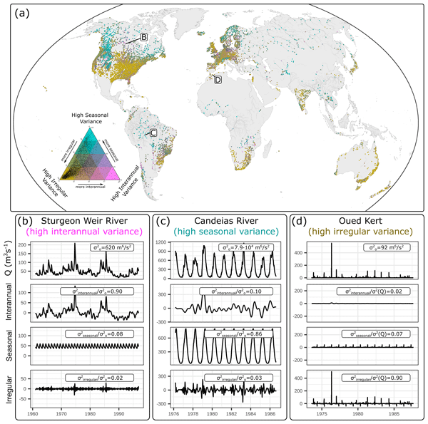
Common metrics used to evaluate hydrologic models make it relatively easy to achieve high performance scores in highly seasonal catchments. However, we analysed 18 hydrologic models and found that almost all were worse at simulating interannual variability and change in seasonal streamflow regimes. This suggests that climate change impacts on streamflow may not be accurately predicted in highly seasonal tropical, alpine, and polar regions, which are highly vulnerable to climate change.
Francesca Pianosi, Georgios Sarailidis, Kirsty Styles, Philip Oldham, Stephen Hutchings, Rob Lamb, and Thorsten Wagener
Nat. Hazards Earth Syst. Sci., 26, 1727–1743, https://doi.org/10.5194/nhess-26-1727-2026, https://doi.org/10.5194/nhess-26-1727-2026, 2026
Short summary
Short summary
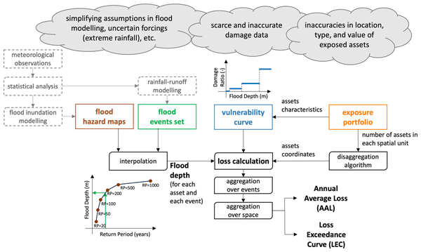
Mathematical modelling is essential to support flood risk management. As these models simulate complex interactions between climate, the natural and the built environment, they unavoidably embed a range of simplifying assumptions. In this paper, we propose a more rigorous approach to analyse the impact of uncertain assumptions on modelling results. This is important to improve model transparency and set priorities for improving models.
Fuqiang Tian, Murugesu Sivapalan, Sondoss El Sawah, Melissa Haeffner, Anthony Jakeman, Heidi Kreibich, Leyang Liu, Haoyang Lyu, Ana Mijic, Jiale Wang, Jing Wei, and Günter Blöschl
EGUsphere, https://doi.org/10.5194/egusphere-2026-1727, https://doi.org/10.5194/egusphere-2026-1727, 2026
Short summary
Short summary
This opinion paper shows how sociohydrology can better support water management by moving from understanding systems to guiding action. Drawing on ten years of work in the Panta Rhei initiative, it offers a simple way to compare cases, trace how actions lead to intended and unintended outcomes, and improve monitoring, learning, fairness, and legitimacy in decision-making.
Patrik Sleziak, Michal Danko, Martin Jančo, Ladislav Holko, and Juraj Parajka
EGUsphere, https://doi.org/10.5194/egusphere-2026-1120, https://doi.org/10.5194/egusphere-2026-1120, 2026
Short summary
Short summary
We compare the Normalized Difference Snow Index from the VIIRS product with daily snow depth observations. The median snow cover mapping accuracy in Austria is 92.5 %. Snow cover classification is more accurate when optimal thresholds are estimated separately for individual months and elevation zones. At the catchment scale, thresholds are lower and mapping accuracy decreases in forested areas, particularly when the snow accumulation starts and at the end of the melting season.
Riccardo Biella, Anastasiya Shyrokaya, Ilias Pechlivanidis, Daniela Cid, Maria Carmen Llasat, Faranak Tootoonchi, Marthe Wens, Marleen Lam, Elin Stenfors, Samuel Sutanto, Elena Ridolfi, Serena Ceola, Pedro Alencar, Giuliano Di Baldassarre, Monica Ionita, Mariana Madruga de Brito, Scott J. McGrane, Benedetta Moccia, Viorica Nagavciuc, Fabio Russo, Svitlana Krakovska, Andrijana Todorovic, Patricia Trambauer, Raffaele Vignola, and Claudia Teutschbein
Nat. Hazards Earth Syst. Sci., 26, 955–979, https://doi.org/10.5194/nhess-26-955-2026, https://doi.org/10.5194/nhess-26-955-2026, 2026
Short summary
Short summary
This research by the Drought in the Anthropocene (DitA) network highlights the crucial role of forecasting systems and Drought Management Plans in European drought risk management. Based on a survey of water managers during the 2022 European drought, it underscores the impact of preparedness on response and the evolution of drought management strategies across the continent, showing how organisations with preparedness measures in place responded faster and more effectively.
Hatice Türk, Christine Stumpp, Markus Hrachowitz, Peter Strauss, Günter Blöschl, and Michael Stockinger
Hydrol. Earth Syst. Sci., 30, 1053–1076, https://doi.org/10.5194/hess-30-1053-2026, https://doi.org/10.5194/hess-30-1053-2026, 2026
Short summary
Short summary
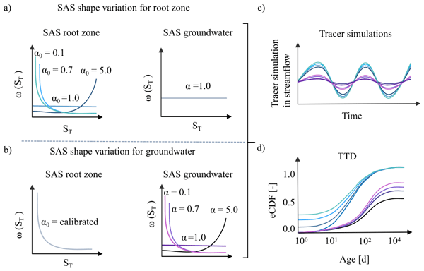
This study shows that streamflow isotope data in a catchment-scale isotope-based transport model were sufficient to isolate preferential flow in the unsaturated zone but insufficient to isolate the preferential release of young groundwater, as isotope signals were strongly damped by large passive groundwater storage. As a result, groundwater age-selection assumptions affected estimates of long transit times, making it difficult to quantify the fraction of stream water older than 100 days.
Thiago V. M. do Nascimento, Julia Rudlang, Sebastian Gnann, Jan Seibert, Markus Hrachowitz, and Fabrizio Fenicia
Hydrol. Earth Syst. Sci., 29, 7173–7200, https://doi.org/10.5194/hess-29-7173-2025, https://doi.org/10.5194/hess-29-7173-2025, 2025
Short summary
Short summary
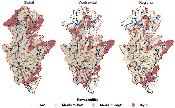
We show that geological maps with varying levels of detail may influence the identification of geology–streamflow relationships across European catchments at multiple scales. At the large scale, controls varied between basins, with no map consistently superior. At the intermediate and small scales, however, higher geological detail consistently strengthened correlations, particularly for baseflow signatures, with the regional map highlighting controls more consistent with process understanding.
Nathalie Rombeek, Markus Hrachowitz, and Remko Uijlenhoet
Hydrol. Earth Syst. Sci., 29, 6715–6733, https://doi.org/10.5194/hess-29-6715-2025, https://doi.org/10.5194/hess-29-6715-2025, 2025
Short summary
Short summary
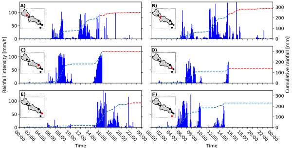
On 29 October 2024 Valencia (Spain) was struck by torrential rainfall, triggering devastating floods in this area. In this study, we quantify and describe the spatial and temporal structure of this rainfall event using personal weather stations (PWSs). These PWSs provide near real-time observations at a temporal resolution of ~5 min. This study shows the potential of PWSs for real-time rainfall monitoring and potentially flood early warning systems by complementing dedicated rain gauge networks.
Riccardo Biella, Anastasiya Shyrokaya, Monica Ionita, Raffaele Vignola, Samuel J. Sutanto, Andrijana Todorovic, Claudia Teutschbein, Daniela Cid, Maria Carmen Llasat, Pedro Alencar, Alessia Matanó, Elena Ridolfi, Benedetta Moccia, Ilias Pechlivanidis, Anne van Loon, Doris E. Wendt, Elin Stenfors, Fabio Russo, Jean-Philippe Vidal, Lucy Barker, Mariana Madruga de Brito, Marleen Lam, Monika Bláhová, Patricia Trambauer, Raed Hamed, Scott J. McGrane, Serena Ceola, Sigrid J. Bakke, Svitlana Krakovska, Viorica Nagavciuc, Faranak Tootoonchi, Giuliano Di Baldassarre, Sandra Hauswirth, Shreedhar Maskey, Svitlana Zubkovych, Marthe Wens, and Lena M. Tallaksen
Nat. Hazards Earth Syst. Sci., 25, 4475–4501, https://doi.org/10.5194/nhess-25-4475-2025, https://doi.org/10.5194/nhess-25-4475-2025, 2025
Short summary
Short summary
The DitA (Drought in the Anthropocene) network's study on the 2022 European drought reveals growing risks, varied impacts, and fragmented, short-term management. Based on a survey of water managers, it explores risk, impacts, strategies, and their evolution. While challenges persist, signs of improvement show readiness for change. The authors call for a European Drought Directive to unify and guide future drought risk management.
Andrea Magnini, Valentina Pavan, and Attilio Castellarin
Hydrol. Earth Syst. Sci., 29, 5031–5047, https://doi.org/10.5194/hess-29-5031-2025, https://doi.org/10.5194/hess-29-5031-2025, 2025
Short summary
Short summary
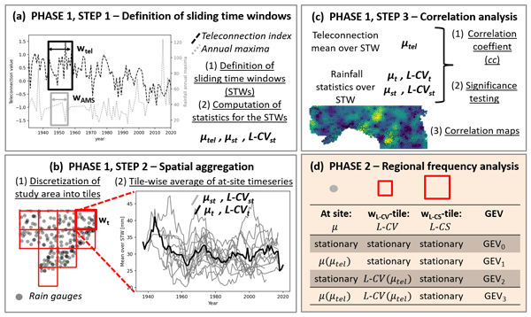
This study describes a new methodology to identify regional structures in the dependence of extreme rainfall on global climate indices. The study area is North-Central Italy, but the methods are highly adaptable to other regions. We observe that while multiple climate indices show influence, the Western Mediterranean Oscillation Index and East Atlantic West Russia pattern appear to have the strongest effects, with regional structures that align with other studies. We also show that using these indices may improve estimation of extreme rainfall depth with a given probability.

Alonso Pizarro, Demetris Koutsoyiannis, and Alberto Montanari
Hydrol. Earth Syst. Sci., 29, 4913–4928, https://doi.org/10.5194/hess-29-4913-2025, https://doi.org/10.5194/hess-29-4913-2025, 2025
Short summary
Short summary
We introduce the ratio of uncertainty to mutual information (RUMI), a new metric to improve rainfall-runoff simulations. RUMI better captures the link between observed and simulated stream flows by considering uncertainty at a core computation step. Tested on 99 catchments and with the GR4J model, it outperforms traditional metrics by providing more reliable and consistent results. RUMI paves the way for more accurate hydrological predictions.
Nathalie Rombeek, Markus Hrachowitz, Arjan Droste, and Remko Uijlenhoet
Hydrol. Earth Syst. Sci., 29, 4585–4606, https://doi.org/10.5194/hess-29-4585-2025, https://doi.org/10.5194/hess-29-4585-2025, 2025
Short summary
Short summary
Rain gauge networks from personal weather stations (PWSs) have a network density 100 times higher than dedicated rain gauge networks in the Netherlands. However, PWSs are prone to several sources of error, as they are generally not installed and maintained according to international guidelines. This study systematically quantifies and describes the uncertainties arising from PWS rainfall estimates. In particular, the focus is on the highest rainfall accumulations.
Maria Elenius, Charlotta Pers, Sara Schützer, Göran Lindström, and Berit Arheimer
Hydrol. Earth Syst. Sci., 29, 4307–4325, https://doi.org/10.5194/hess-29-4307-2025, https://doi.org/10.5194/hess-29-4307-2025, 2025
Short summary
Short summary
Simulations of peatland rewetting in Sweden under various conditions of climate, local hydrology, and rewetting practices showed insubstantial changes in landscape flow extremes due to mixing with runoff from various landcovers. The impacts on local hydrological extremes are governed by groundwater levels prior to rewetting and reduced tree cover; hence wetland allocation and management practices are crucial if the purpose is to reduce flow extremes in peatland streams.
Hatice Türk, Christine Stumpp, Markus Hrachowitz, Karsten Schulz, Peter Strauss, Günter Blöschl, and Michael Stockinger
Hydrol. Earth Syst. Sci., 29, 3935–3956, https://doi.org/10.5194/hess-29-3935-2025, https://doi.org/10.5194/hess-29-3935-2025, 2025
Short summary
Short summary
Using advances in transit time estimation and tracer data, we tested if fast-flow transit times are controlled solely by soil moisture or if they are also controlled by precipitation intensity. We used soil-moisture-dependent and precipitation-intensity-conditional transfer functions. We showed that a significant portion of event water bypasses the soil matrix through fast flow paths (overland flow, tile drains, preferential-flow paths) in dry soil conditions for both low- and high-intensity precipitation.
Magali Ponds, Sarah Hanus, Harry Zekollari, Marie-Claire ten Veldhuis, Gerrit Schoups, Roland Kaitna, and Markus Hrachowitz
Hydrol. Earth Syst. Sci., 29, 3545–3568, https://doi.org/10.5194/hess-29-3545-2025, https://doi.org/10.5194/hess-29-3545-2025, 2025
Short summary
Short summary
This research examines how future climate changes impact root zone storage, a key hydrological model parameter. Root zone storage – the soil water accessible to plants – adapts to climate but is often kept constant in models. We estimated climate-adapted storage in six Austrian Alps catchments. While storage increased, streamflow projections showed minimal change, which suggests that dynamic root zone representation is less critical in humid regions but warrants further study in arid areas.
Christopher Thoma, Borbala Szeles, Miriam Bertola, Elmar Schmaltz, Carmen Krammer, Peter Strauss, and Günter Blöschl
EGUsphere, https://doi.org/10.5194/egusphere-2025-2541, https://doi.org/10.5194/egusphere-2025-2541, 2025
Preprint archived
Short summary
Short summary
We studied how farming practices affect soil and sediment movement in a small Austrian catchment. By monitoring water and sediment during 55 rain events, we found that erosion control worked well in flat fields near the stream, but not in steep or distant fields. Our results show that reducing soil loss requires strategies that consider slope, distance to streams, and how water flows through the landscape.
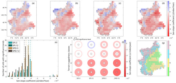
Emanuele Mombrini, Stefania Tamea, Alberto Viglione, and Roberto Revelli
Hydrol. Earth Syst. Sci., 29, 2255–2273, https://doi.org/10.5194/hess-29-2255-2025, https://doi.org/10.5194/hess-29-2255-2025, 2025
Short summary
Short summary
In northwestern Italy, overall drought conditions appear to have worsened over the last 60 years due to both precipitation deficits and increased evapotranspiration caused by temperature increases. In addition to changes in drought conditions, changes in the characteristics of drought periods, both at a local and at a region-wide level, are found. Links between all the aforementioned changes and terrain characteristics are highlighted, finding generally worse conditions in lower-lying areas.
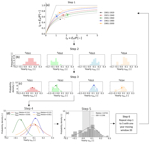
Muhammad Ibrahim, Miriam Coenders-Gerrits, Ruud van der Ent, and Markus Hrachowitz
Hydrol. Earth Syst. Sci., 29, 1703–1723, https://doi.org/10.5194/hess-29-1703-2025, https://doi.org/10.5194/hess-29-1703-2025, 2025
Short summary
Short summary
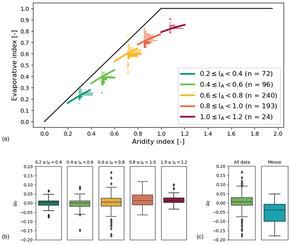
The quantification of precipitation into evaporation and runoff is vital for water resources management. The Budyko framework, based on aridity and evaporative indices of a catchment, can be an ideal tool for that. However, recent research highlights deviations of catchments from the expected evaporative index, casting doubt on its reliability. This study quantifies deviations of 2387 catchments, finding them minor and predictable. Integrating these into predictions upholds the framework's efficacy.
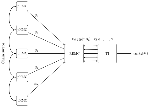
Damian N. Mingo, Remko Nijzink, Christophe Ley, and Jack S. Hale
Geosci. Model Dev., 18, 1709–1736, https://doi.org/10.5194/gmd-18-1709-2025, https://doi.org/10.5194/gmd-18-1709-2025, 2025
Short summary
Short summary
Hydrologists are often faced with selecting amongst a set of competing models with different numbers of parameters and ability to fit available data. Bayes’ factor is a tool that can be used to compare models; however, it is very difficult to compute Bayes' factor numerically. In our paper, we explore and develop highly efficient algorithms for computing Bayes’ factor of hydrological systems, which will introduce this useful tool for selecting models into everyday hydrological practice.
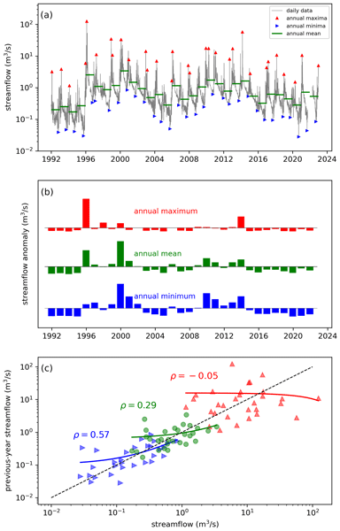
Wouter R. Berghuijs, Ross A. Woods, Bailey J. Anderson, Anna Luisa Hemshorn de Sánchez, and Markus Hrachowitz
Hydrol. Earth Syst. Sci., 29, 1319–1333, https://doi.org/10.5194/hess-29-1319-2025, https://doi.org/10.5194/hess-29-1319-2025, 2025
Short summary
Short summary
Water balances of catchments will often strongly depend on their state in the recent past, but such memory effects may persist at annual timescales. We use global data sets to show that annual memory is typically absent in precipitation but strong in terrestrial water stores and also present in evaporation and streamflow (including low flows and floods). Our experiments show that hysteretic models provide behaviour that is consistent with these observed memory behaviours.
Léonard Santos, Vazken Andréassian, Torben O. Sonnenborg, Göran Lindström, Alban de Lavenne, Charles Perrin, Lila Collet, and Guillaume Thirel
Hydrol. Earth Syst. Sci., 29, 683–700, https://doi.org/10.5194/hess-29-683-2025, https://doi.org/10.5194/hess-29-683-2025, 2025
Short summary
Short summary
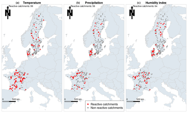
This work investigates how hydrological models are transferred to a period in which climate conditions are different to the ones of the period in which they were set up. The robustness assessment test built to detect dependencies between model error and climatic drivers was applied to three hydrological models in 352 catchments in Denmark, France and Sweden. Potential issues are seen in a significant number of catchments for the models, even though the catchments differ for each model.
Paolo Nasta, Günter Blöschl, Heye R. Bogena, Steffen Zacharias, Roland Baatz, Gabriëlle De Lannoy, Karsten H. Jensen, Salvatore Manfreda, Laurent Pfister, Ana M. Tarquis, Ilja van Meerveld, Marc Voltz, Yijian Zeng, William Kustas, Xin Li, Harry Vereecken, and Nunzio Romano
Hydrol. Earth Syst. Sci., 29, 465–483, https://doi.org/10.5194/hess-29-465-2025, https://doi.org/10.5194/hess-29-465-2025, 2025
Short summary
Short summary
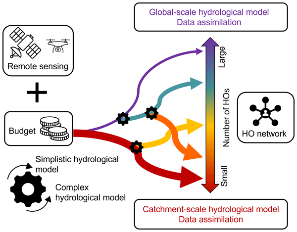
The Unsolved Problems in Hydrology (UPH) initiative has emphasized the need to establish networks of multi-decadal hydrological observatories to tackle catchment-scale challenges on a global scale. This opinion paper provocatively discusses two endmembers of possible future hydrological observatory (HO) networks for a given hypothesized community budget: a comprehensive set of moderately instrumented observatories or, alternatively, a small number of highly instrumented supersites.
Jordy Salmon-Monviola, Ophélie Fovet, and Markus Hrachowitz
Hydrol. Earth Syst. Sci., 29, 127–158, https://doi.org/10.5194/hess-29-127-2025, https://doi.org/10.5194/hess-29-127-2025, 2025
Short summary
Short summary
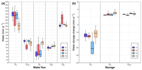
To increase the predictive power of hydrological models, it is necessary to improve their consistency, i.e. their physical realism, which is measured by the ability of the model to reproduce observed system dynamics. Using a model to represent the dynamics of water and nitrate and dissolved organic carbon concentrations in an agricultural catchment, we showed that using solute-concentration data for calibration is useful to improve the hydrological consistency of the model.
Bruno Merz, Günter Blöschl, Robert Jüpner, Heidi Kreibich, Kai Schröter, and Sergiy Vorogushyn
Nat. Hazards Earth Syst. Sci., 24, 4015–4030, https://doi.org/10.5194/nhess-24-4015-2024, https://doi.org/10.5194/nhess-24-4015-2024, 2024
Short summary
Short summary
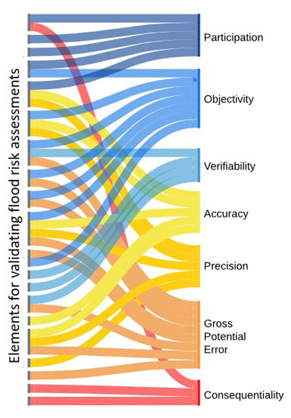
Flood risk assessments help us decide how to reduce the risk of flooding. Since these assessments are based on probabilities, it is hard to check their accuracy by comparing them to past data. We suggest a new way to validate these assessments, making sure they are practical for real-life decisions. This approach looks at both the technical details and the real-world situations where decisions are made. We demonstrate its practicality by applying it to flood emergency planning.
Nienke Tempel, Laurène Bouaziz, Riccardo Taormina, Ellis van Noppen, Jasper Stam, Eric Sprokkereef, and Markus Hrachowitz
Hydrol. Earth Syst. Sci., 28, 4577–4597, https://doi.org/10.5194/hess-28-4577-2024, https://doi.org/10.5194/hess-28-4577-2024, 2024
Short summary
Short summary
This study explores the impact of climatic variability on root zone water storage capacities and, thus, on hydrological predictions. Analysing data from 286 areas in Europe and the US, we found that, despite some variations in root zone storage capacity due to changing climatic conditions over multiple decades, these changes are generally minor and have a limited effect on water storage and river flow predictions.
Hongkai Gao, Markus Hrachowitz, Lan Wang-Erlandsson, Fabrizio Fenicia, Qiaojuan Xi, Jianyang Xia, Wei Shao, Ge Sun, and Hubert H. G. Savenije
Hydrol. Earth Syst. Sci., 28, 4477–4499, https://doi.org/10.5194/hess-28-4477-2024, https://doi.org/10.5194/hess-28-4477-2024, 2024
Short summary
Short summary
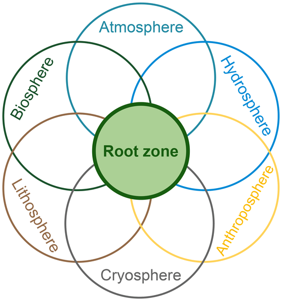
The concept of the root zone is widely used but lacks a precise definition. Its importance in Earth system science is not well elaborated upon. Here, we clarified its definition with several similar terms to bridge the multi-disciplinary gap. We underscore the key role of the root zone in the Earth system, which links the biosphere, hydrosphere, lithosphere, atmosphere, and anthroposphere. To better represent the root zone, we advocate for a paradigm shift towards ecosystem-centred modelling.
Cristina Prieto, Dhruvesh Patel, Dawei Han, Benjamin Dewals, Michaela Bray, and Daniela Molinari
Nat. Hazards Earth Syst. Sci., 24, 3381–3386, https://doi.org/10.5194/nhess-24-3381-2024, https://doi.org/10.5194/nhess-24-3381-2024, 2024
Shervan Gharari, Paul H. Whitfield, Alain Pietroniro, Jim Freer, Hongli Liu, and Martyn P. Clark
Hydrol. Earth Syst. Sci., 28, 4383–4405, https://doi.org/10.5194/hess-28-4383-2024, https://doi.org/10.5194/hess-28-4383-2024, 2024
Short summary
Short summary
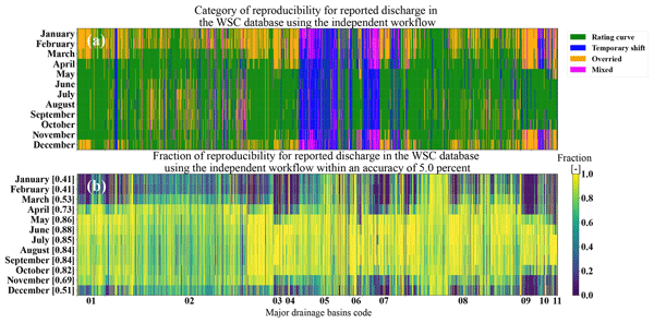
This study provides insight into the practices that are incorporated into discharge estimation across the national Canadian hydrometric network operated by the Water Survey of Canada (WSC). The procedures used to estimate and correct discharge values are not always understood by end-users. Factors such as ice cover and sedimentation limit accurate discharge estimation. Highlighting these challenges sheds light on difficulties in discharge estimation and the associated uncertainty.
Franziska Clerc-Schwarzenbach, Giovanni Selleri, Mattia Neri, Elena Toth, Ilja van Meerveld, and Jan Seibert
Hydrol. Earth Syst. Sci., 28, 4219–4237, https://doi.org/10.5194/hess-28-4219-2024, https://doi.org/10.5194/hess-28-4219-2024, 2024
Short summary
Short summary
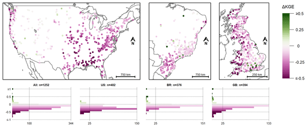
We show that the differences between the forcing data included in three CAMELS datasets (US, BR, GB) and the forcing data included for the same catchments in the Caravan dataset affect model calibration considerably. The model performance dropped when the data from the Caravan dataset were used instead of the original data. Most of the model performance drop could be attributed to the differences in precipitation data. However, differences were largest for the potential evapotranspiration data.
Saskia Salwey, Gemma Coxon, Francesca Pianosi, Rosanna Lane, Chris Hutton, Michael Bliss Singer, Hilary McMillan, and Jim Freer
Hydrol. Earth Syst. Sci., 28, 4203–4218, https://doi.org/10.5194/hess-28-4203-2024, https://doi.org/10.5194/hess-28-4203-2024, 2024
Short summary
Short summary
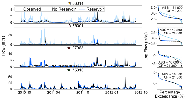
Reservoirs are essential for water resource management and can significantly impact downstream flow. However, representing reservoirs in hydrological models can be challenging, particularly across large scales. We design a new and simple method for simulating river flow downstream of water supply reservoirs using only open-access data. We demonstrate the approach in 264 reservoir catchments across Great Britain, where we can significantly improve the simulation of reservoir-impacted flow.
Siyuan Wang, Markus Hrachowitz, and Gerrit Schoups
Hydrol. Earth Syst. Sci., 28, 4011–4033, https://doi.org/10.5194/hess-28-4011-2024, https://doi.org/10.5194/hess-28-4011-2024, 2024
Short summary
Short summary
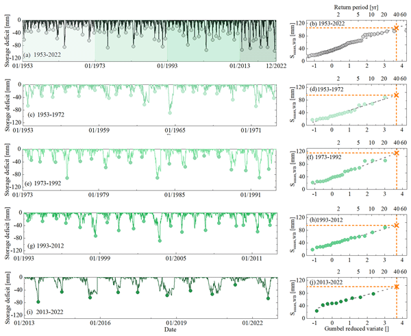
Root zone storage capacity (Sumax) changes significantly over multiple decades, reflecting vegetation adaptation to climatic variability. However, this temporal evolution of Sumax cannot explain long-term fluctuations in the partitioning of water fluxes as expressed by deviations ΔIE from the parametric Budyko curve over time with different climatic conditions, and it does not have any significant effects on shorter-term hydrological response characteristics of the upper Neckar catchment.
Günter Blöschl, Andreas Buttinger-Kreuzhuber, Daniel Cornel, Julia Eisl, Michael Hofer, Markus Hollaus, Zsolt Horváth, Jürgen Komma, Artem Konev, Juraj Parajka, Norbert Pfeifer, Andreas Reithofer, José Salinas, Peter Valent, Roman Výleta, Jürgen Waser, Michael H. Wimmer, and Heinz Stiefelmeyer
Nat. Hazards Earth Syst. Sci., 24, 2071–2091, https://doi.org/10.5194/nhess-24-2071-2024, https://doi.org/10.5194/nhess-24-2071-2024, 2024
Short summary
Short summary
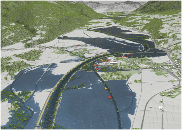
A methodology of regional flood hazard mapping is proposed, based on data in Austria, which combines automatic methods with manual interventions to maximise efficiency and to obtain estimation accuracy similar to that of local studies. Flood discharge records from 781 stations are used to estimate flood hazard patterns of a given return period at a resolution of 2 m over a total stream length of 38 000 km. The hazard maps are used for civil protection, risk awareness and insurance purposes.
Alberto Montanari, Bruno Merz, and Günter Blöschl
Hydrol. Earth Syst. Sci., 28, 2603–2615, https://doi.org/10.5194/hess-28-2603-2024, https://doi.org/10.5194/hess-28-2603-2024, 2024
Short summary
Short summary
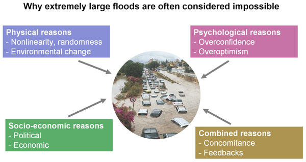
Floods often take communities by surprise, as they are often considered virtually
impossibleyet are an ever-present threat similar to the sword suspended over the head of Damocles in the classical Greek anecdote. We discuss four reasons why extremely large floods carry a risk that is often larger than expected. We provide suggestions for managing the risk of megafloods by calling for a creative exploration of hazard scenarios and communicating the unknown corners of the reality of floods.
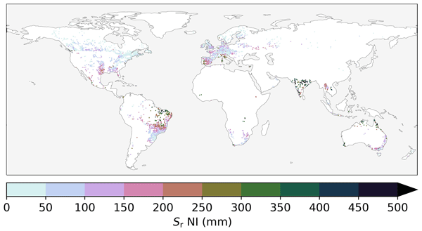
Fransje van Oorschot, Ruud J. van der Ent, Andrea Alessandri, and Markus Hrachowitz
Hydrol. Earth Syst. Sci., 28, 2313–2328, https://doi.org/10.5194/hess-28-2313-2024, https://doi.org/10.5194/hess-28-2313-2024, 2024
Short summary
Short summary
Vegetation plays a crucial role in regulating the water cycle by transporting water from the subsurface to the atmosphere via roots; this transport depends on the extent of the root system. In this study, we quantified the effect of irrigation on roots at a global scale. Our results emphasize the importance of accounting for irrigation in estimating the vegetation root extent, which is essential to adequately represent the water cycle in hydrological and climate models.
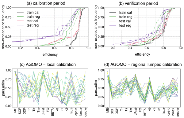
Matteo Pesce, Alberto Viglione, Jost von Hardenberg, Larisa Tarasova, Stefano Basso, Ralf Merz, Juraj Parajka, and Rui Tong
Proc. IAHS, 385, 65–69, https://doi.org/10.5194/piahs-385-65-2024, https://doi.org/10.5194/piahs-385-65-2024, 2024
Short summary
Short summary
The manuscript describes an application of PArameter Set Shuffling (PASS) approach in the Alpine region. A machine learning decision-tree algorithm is applied for the regional calibration of a conceptual semi-distributed hydrological model. Regional model efficiencies don't decrease significantly when moving in space from catchments used for the regional calibration (training) to catchments used for the procedure validation (test) and, in time, from the calibration to the verification period.
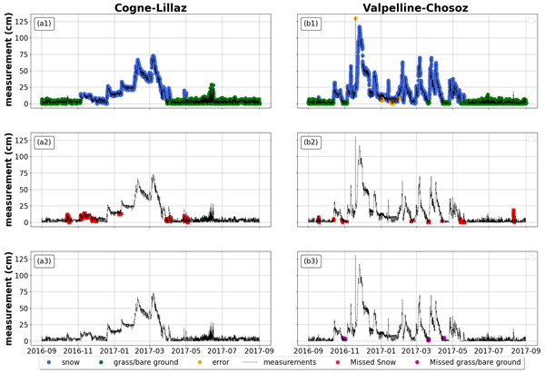
Giulia Blandini, Francesco Avanzi, Simone Gabellani, Denise Ponziani, Hervé Stevenin, Sara Ratto, Luca Ferraris, and Alberto Viglione
The Cryosphere, 17, 5317–5333, https://doi.org/10.5194/tc-17-5317-2023, https://doi.org/10.5194/tc-17-5317-2023, 2023
Short summary
Short summary
Automatic snow depth data are a valuable source of information for hydrologists, but they also tend to be noisy. To maximize the value of these measurements for real-world applications, we developed an automatic procedure to differentiate snow cover from grass or bare ground data, as well as to detect random errors. This procedure can enhance snow data quality, thus providing more reliable data for snow models.
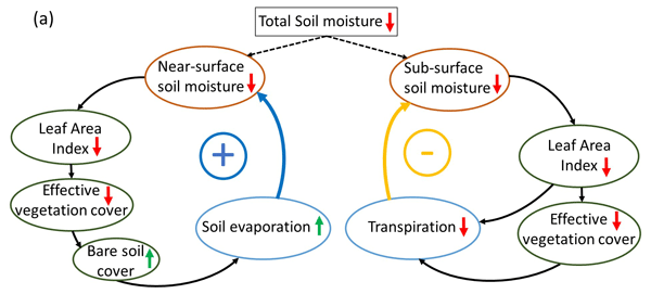
Fransje van Oorschot, Ruud J. van der Ent, Markus Hrachowitz, Emanuele Di Carlo, Franco Catalano, Souhail Boussetta, Gianpaolo Balsamo, and Andrea Alessandri
Earth Syst. Dynam., 14, 1239–1259, https://doi.org/10.5194/esd-14-1239-2023, https://doi.org/10.5194/esd-14-1239-2023, 2023
Short summary
Short summary
Vegetation largely controls land hydrology by transporting water from the subsurface to the atmosphere through roots and is highly variable in space and time. However, current land surface models have limitations in capturing this variability at a global scale, limiting accurate modeling of land hydrology. We found that satellite-based vegetation variability considerably improved modeled land hydrology and therefore has potential to improve climate predictions of, for example, droughts.
Siyuan Wang, Markus Hrachowitz, Gerrit Schoups, and Christine Stumpp
Hydrol. Earth Syst. Sci., 27, 3083–3114, https://doi.org/10.5194/hess-27-3083-2023, https://doi.org/10.5194/hess-27-3083-2023, 2023
Short summary
Short summary
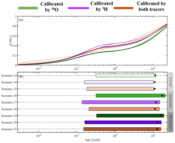
This study shows that previously reported underestimations of water ages are most likely not due to the use of seasonally variable tracers. Rather, these underestimations can be largely attributed to the choices of model approaches which rely on assumptions not frequently met in catchment hydrology. We therefore strongly advocate avoiding the use of this model type in combination with seasonally variable tracers and instead adopting StorAge Selection (SAS)-based or comparable model formulations.
Rui Guo and Alberto Montanari
Hydrol. Earth Syst. Sci., 27, 2847–2863, https://doi.org/10.5194/hess-27-2847-2023, https://doi.org/10.5194/hess-27-2847-2023, 2023
Short summary
Short summary
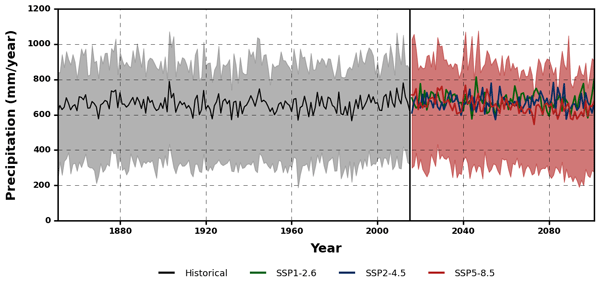
The present study refers to the region of Bologna, where the availability of a 209-year-long daily rainfall series allows us to make a unique assessment of global climate models' reliability and their predicted changes in rainfall and multiyear droughts. Our results suggest carefully considering the impact of uncertainty when designing climate change adaptation policies for droughts. Rigorous use and comprehensive interpretation of the available information are needed to avoid mismanagement.
Trevor Page, Paul Smith, Keith Beven, Francesca Pianosi, Fanny Sarrazin, Susana Almeida, Liz Holcombe, Jim Freer, Nick Chappell, and Thorsten Wagener
Hydrol. Earth Syst. Sci., 27, 2523–2534, https://doi.org/10.5194/hess-27-2523-2023, https://doi.org/10.5194/hess-27-2523-2023, 2023
Short summary
Short summary
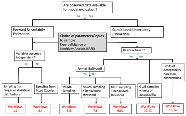
This publication provides an introduction to the CREDIBLE Uncertainty Estimation (CURE) toolbox. CURE offers workflows for a variety of uncertainty estimation methods. One of its most important features is the requirement that all of the assumptions on which a workflow analysis depends be defined. This facilitates communication with potential users of an analysis. An audit trail log is produced automatically from a workflow for future reference.
Heidi Kreibich, Kai Schröter, Giuliano Di Baldassarre, Anne F. Van Loon, Maurizio Mazzoleni, Guta Wakbulcho Abeshu, Svetlana Agafonova, Amir AghaKouchak, Hafzullah Aksoy, Camila Alvarez-Garreton, Blanca Aznar, Laila Balkhi, Marlies H. Barendrecht, Sylvain Biancamaria, Liduin Bos-Burgering, Chris Bradley, Yus Budiyono, Wouter Buytaert, Lucinda Capewell, Hayley Carlson, Yonca Cavus, Anaïs Couasnon, Gemma Coxon, Ioannis Daliakopoulos, Marleen C. de Ruiter, Claire Delus, Mathilde Erfurt, Giuseppe Esposito, Didier François, Frédéric Frappart, Jim Freer, Natalia Frolova, Animesh K. Gain, Manolis Grillakis, Jordi Oriol Grima, Diego A. Guzmán, Laurie S. Huning, Monica Ionita, Maxim Kharlamov, Dao Nguyen Khoi, Natalie Kieboom, Maria Kireeva, Aristeidis Koutroulis, Waldo Lavado-Casimiro, Hong-Yi Li, Maria Carmen LLasat, David Macdonald, Johanna Mård, Hannah Mathew-Richards, Andrew McKenzie, Alfonso Mejia, Eduardo Mario Mendiondo, Marjolein Mens, Shifteh Mobini, Guilherme Samprogna Mohor, Viorica Nagavciuc, Thanh Ngo-Duc, Huynh Thi Thao Nguyen, Pham Thi Thao Nhi, Olga Petrucci, Nguyen Hong Quan, Pere Quintana-Seguí, Saman Razavi, Elena Ridolfi, Jannik Riegel, Md Shibly Sadik, Nivedita Sairam, Elisa Savelli, Alexey Sazonov, Sanjib Sharma, Johanna Sörensen, Felipe Augusto Arguello Souza, Kerstin Stahl, Max Steinhausen, Michael Stoelzle, Wiwiana Szalińska, Qiuhong Tang, Fuqiang Tian, Tamara Tokarczyk, Carolina Tovar, Thi Van Thu Tran, Marjolein H. J. van Huijgevoort, Michelle T. H. van Vliet, Sergiy Vorogushyn, Thorsten Wagener, Yueling Wang, Doris E. Wendt, Elliot Wickham, Long Yang, Mauricio Zambrano-Bigiarini, and Philip J. Ward
Earth Syst. Sci. Data, 15, 2009–2023, https://doi.org/10.5194/essd-15-2009-2023, https://doi.org/10.5194/essd-15-2009-2023, 2023
Short summary
Short summary
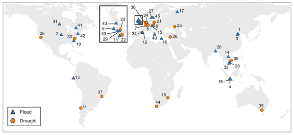
As the adverse impacts of hydrological extremes increase in many regions of the world, a better understanding of the drivers of changes in risk and impacts is essential for effective flood and drought risk management. We present a dataset containing data of paired events, i.e. two floods or two droughts that occurred in the same area. The dataset enables comparative analyses and allows detailed context-specific assessments. Additionally, it supports the testing of socio-hydrological models.
Mohammad Ghoreishi, Amin Elshorbagy, Saman Razavi, Günter Blöschl, Murugesu Sivapalan, and Ahmed Abdelkader
Hydrol. Earth Syst. Sci., 27, 1201–1219, https://doi.org/10.5194/hess-27-1201-2023, https://doi.org/10.5194/hess-27-1201-2023, 2023
Short summary
Short summary
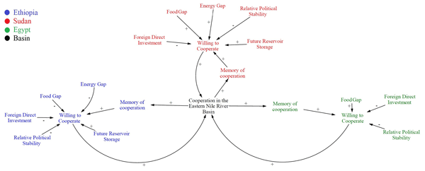
The study proposes a quantitative model of the willingness to cooperate in the Eastern Nile River basin. Our results suggest that the 2008 food crisis may account for Sudan recovering its willingness to cooperate with Ethiopia. Long-term lack of trust among the riparian countries may have reduced basin-wide cooperation. The model can be used to explore the effects of changes in future dam operations and other management decisions on the emergence of basin cooperation.

Louisa D. Oldham, Jim Freer, Gemma Coxon, Nicholas Howden, John P. Bloomfield, and Christopher Jackson
Hydrol. Earth Syst. Sci., 27, 761–781, https://doi.org/10.5194/hess-27-761-2023, https://doi.org/10.5194/hess-27-761-2023, 2023
Short summary
Short summary
Water can move between river catchments via the subsurface, termed intercatchment groundwater flow (IGF). We show how a perceptual model of IGF can be developed with relatively simple geological interpretation and data requirements. We find that IGF dynamics vary in space, correlated to the dominant underlying geology. We recommend that IGF
loss functionsmay be used in conceptual rainfall–runoff models but should be supported by perceptualisation of IGF processes and connectivities.
Remko C. Nijzink and Stanislaus J. Schymanski
Hydrol. Earth Syst. Sci., 26, 6289–6309, https://doi.org/10.5194/hess-26-6289-2022, https://doi.org/10.5194/hess-26-6289-2022, 2022
Short summary
Short summary
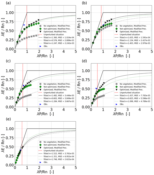
Most catchments plot close to the empirical Budyko curve, which allows for estimating the long-term mean annual evaporation and runoff. We found that a model that optimizes vegetation properties in response to changes in precipitation leads it to converge to a single curve. In contrast, models that assume no changes in vegetation start to deviate from a single curve. This implies that vegetation has a stabilizing role, bringing catchments back to equilibrium after changes in climate.
Enrico Bonanno, Günter Blöschl, and Julian Klaus
Hydrol. Earth Syst. Sci., 26, 6003–6028, https://doi.org/10.5194/hess-26-6003-2022, https://doi.org/10.5194/hess-26-6003-2022, 2022
Short summary
Short summary
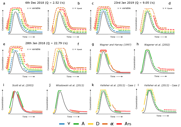
There is an unclear understanding of which processes regulate the transport of water, solutes, and pollutants in streams. This is crucial since these processes control water quality in river networks. Compared to other approaches, we obtained clearer insights into the processes controlling solute transport in the investigated reach. This work highlights the risks of using uncertain results for interpreting the processes controlling water movement in streams.

Pau Wiersma, Jerom Aerts, Harry Zekollari, Markus Hrachowitz, Niels Drost, Matthias Huss, Edwin H. Sutanudjaja, and Rolf Hut
Hydrol. Earth Syst. Sci., 26, 5971–5986, https://doi.org/10.5194/hess-26-5971-2022, https://doi.org/10.5194/hess-26-5971-2022, 2022
Short summary
Short summary
We test whether coupling a global glacier model (GloGEM) with a global hydrological model (PCR-GLOBWB 2) leads to a more realistic glacier representation and to improved basin runoff simulations across 25 large-scale basins. The coupling does lead to improved glacier representation, mainly by accounting for glacier flow and net glacier mass loss, and to improved basin runoff simulations, mostly in strongly glacier-influenced basins, which is where the coupling has the most impact.
Judith Uwihirwe, Alessia Riveros, Hellen Wanjala, Jaap Schellekens, Frederiek Sperna Weiland, Markus Hrachowitz, and Thom A. Bogaard
Nat. Hazards Earth Syst. Sci., 22, 3641–3661, https://doi.org/10.5194/nhess-22-3641-2022, https://doi.org/10.5194/nhess-22-3641-2022, 2022
Short summary
Short summary
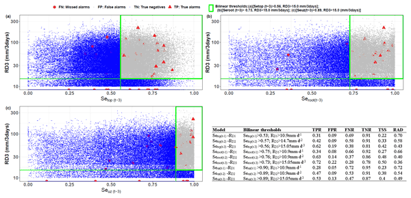
This study compared gauge-based and satellite-based precipitation products. Similarly, satellite- and hydrological model-derived soil moisture was compared to in situ soil moisture and used in landslide hazard assessment and warning. The results reveal the cumulative 3 d rainfall from the NASA-GPM to be the most effective landslide trigger. The modelled antecedent soil moisture in the root zone was the most informative hydrological variable for landslide hazard assessment and warning in Rwanda.
Rosanna A. Lane, Gemma Coxon, Jim Freer, Jan Seibert, and Thorsten Wagener
Hydrol. Earth Syst. Sci., 26, 5535–5554, https://doi.org/10.5194/hess-26-5535-2022, https://doi.org/10.5194/hess-26-5535-2022, 2022
Short summary
Short summary
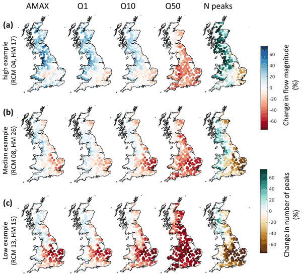
This study modelled the impact of climate change on river high flows across Great Britain (GB). Generally, results indicated an increase in the magnitude and frequency of high flows along the west coast of GB by 2050–2075. In contrast, average flows decreased across GB. All flow projections contained large uncertainties; the climate projections were the largest source of uncertainty overall but hydrological modelling uncertainties were considerable in some regions.
Günter Blöschl
Hydrol. Earth Syst. Sci., 26, 5015–5033, https://doi.org/10.5194/hess-26-5015-2022, https://doi.org/10.5194/hess-26-5015-2022, 2022
Short summary
Short summary
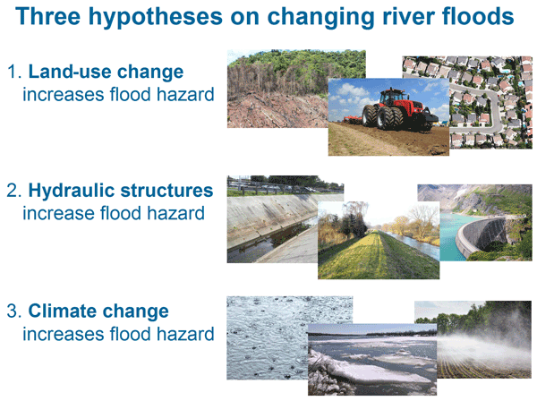
There is serious concern that river floods are increasing. Starting from explanations discussed in public, the article addresses three hypotheses: land-use change, hydraulic structures, and climate change increase floods. This review finds that all three changes have the potential to not only increase floods, but also to reduce them. It is crucial to consider all three factors of change in flood risk management and communicate them to the general public in a nuanced way.
Simone Persiano, Alessio Pugliese, Alberto Aloe, Jon Olav Skøien, Attilio Castellarin, and Alberto Pistocchi
Earth Syst. Sci. Data, 14, 4435–4443, https://doi.org/10.5194/essd-14-4435-2022, https://doi.org/10.5194/essd-14-4435-2022, 2022
Short summary
Short summary
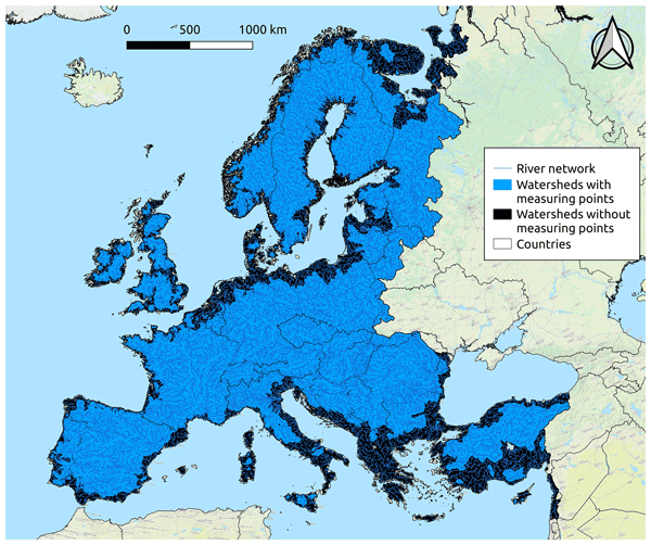
For about 24000 river basins across Europe, this study provides a continuous representation of the streamflow regime in terms of empirical flow–duration curves (FDCs), which are key signatures of the hydrological behaviour of a catchment and are widely used for supporting decisions on water resource management as well as for assessing hydrologic change. FDCs at ungauged sites are estimated by means of a geostatistical procedure starting from data observed at about 3000 sites across Europe.
Remko C. Nijzink and Stanislaus J. Schymanski
Hydrol. Earth Syst. Sci., 26, 4575–4585, https://doi.org/10.5194/hess-26-4575-2022, https://doi.org/10.5194/hess-26-4575-2022, 2022
Short summary
Short summary
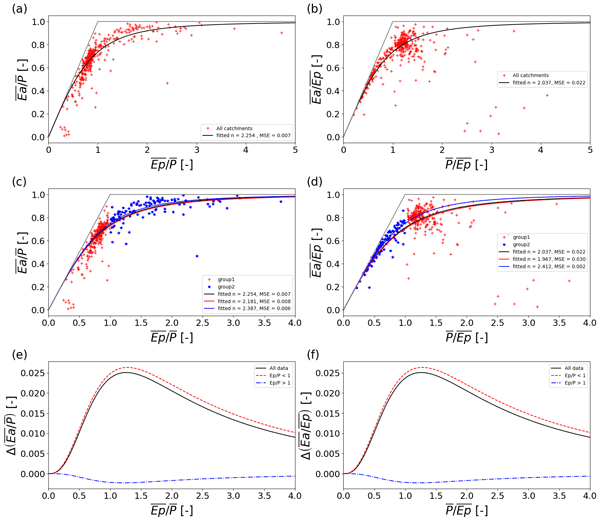
Most catchments plot close to the empirical Budyko curve, which allows for the estimation of the long-term mean annual evaporation and runoff. The Budyko curve can be defined as a function of a wetness index or a dryness index. We found that differences can occur and that there is an uncertainty due to the different formulations.
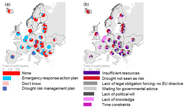
Veit Blauhut, Michael Stoelzle, Lauri Ahopelto, Manuela I. Brunner, Claudia Teutschbein, Doris E. Wendt, Vytautas Akstinas, Sigrid J. Bakke, Lucy J. Barker, Lenka Bartošová, Agrita Briede, Carmelo Cammalleri, Ksenija Cindrić Kalin, Lucia De Stefano, Miriam Fendeková, David C. Finger, Marijke Huysmans, Mirjana Ivanov, Jaak Jaagus, Jiří Jakubínský, Svitlana Krakovska, Gregor Laaha, Monika Lakatos, Kiril Manevski, Mathias Neumann Andersen, Nina Nikolova, Marzena Osuch, Pieter van Oel, Kalina Radeva, Renata J. Romanowicz, Elena Toth, Mirek Trnka, Marko Urošev, Julia Urquijo Reguera, Eric Sauquet, Aleksandra Stevkov, Lena M. Tallaksen, Iryna Trofimova, Anne F. Van Loon, Michelle T. H. van Vliet, Jean-Philippe Vidal, Niko Wanders, Micha Werner, Patrick Willems, and Nenad Živković
Nat. Hazards Earth Syst. Sci., 22, 2201–2217, https://doi.org/10.5194/nhess-22-2201-2022, https://doi.org/10.5194/nhess-22-2201-2022, 2022
Short summary
Short summary
Recent drought events caused enormous damage in Europe. We therefore questioned the existence and effect of current drought management strategies on the actual impacts and how drought is perceived by relevant stakeholders. Over 700 participants from 28 European countries provided insights into drought hazard and impact perception and current management strategies. The study concludes with an urgent need to collectively combat drought risk via a European macro-level drought governance approach.
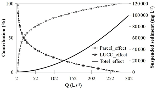
Shengping Wang, Borbala Szeles, Carmen Krammer, Elmar Schmaltz, Kepeng Song, Yifan Li, Zhiqiang Zhang, Günter Blöschl, and Peter Strauss
Hydrol. Earth Syst. Sci., 26, 3021–3036, https://doi.org/10.5194/hess-26-3021-2022, https://doi.org/10.5194/hess-26-3021-2022, 2022
Short summary
Short summary
This study explored the quantitative contribution of agricultural intensification and climate change to the sediment load of a small agricultural watershed. Rather than a change in climatic conditions, changes in the land structure notably altered sediment concentrations under high-flow conditions, thereby contributing most to the increase in annual sediment loads. More consideration of land structure improvement is required when combating the transfer of soil from land to water.
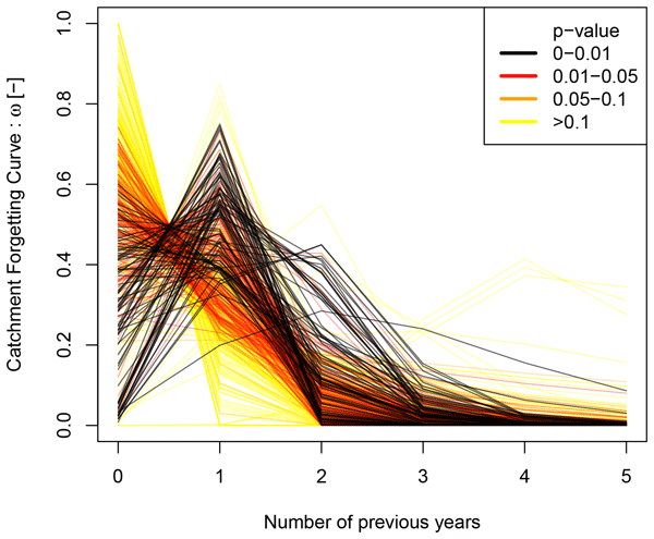
Alban de Lavenne, Vazken Andréassian, Louise Crochemore, Göran Lindström, and Berit Arheimer
Hydrol. Earth Syst. Sci., 26, 2715–2732, https://doi.org/10.5194/hess-26-2715-2022, https://doi.org/10.5194/hess-26-2715-2022, 2022
Short summary
Short summary
A watershed remembers the past to some extent, and this memory influences its behavior. This memory is defined by the ability to store past rainfall for several years. By releasing this water into the river or the atmosphere, it tends to forget. We describe how this memory fades over time in France and Sweden. A few watersheds show a multi-year memory. It increases with the influence of groundwater or dry conditions. After 3 or 4 years, they behave independently of the past.
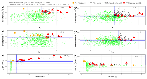
Judith Uwihirwe, Markus Hrachowitz, and Thom Bogaard
Nat. Hazards Earth Syst. Sci., 22, 1723–1742, https://doi.org/10.5194/nhess-22-1723-2022, https://doi.org/10.5194/nhess-22-1723-2022, 2022
Short summary
Short summary
This research tested the value of regional groundwater level information to improve landslide predictions with empirical models based on the concept of threshold levels. In contrast to precipitation-based thresholds, the results indicated that relying on threshold models exclusively defined using hydrological variables such as groundwater levels can lead to improved landslide predictions due to their implicit consideration of long-term antecedent conditions until the day of landslide occurrence.

Günter Blöschl
Hydrol. Earth Syst. Sci., 26, 2469–2480, https://doi.org/10.5194/hess-26-2469-2022, https://doi.org/10.5194/hess-26-2469-2022, 2022
Short summary
Short summary
Sound understanding of how floods come about allows for the development of more reliable flood management tools that assist in mitigating their negative impacts. This article reviews river flood generation processes and flow paths across space scales, starting from water movement in the soil pores and moving up to hillslopes, catchments, regions and entire continents. To assist model development, there is a need to learn from observed patterns of flood generation processes at all spatial scales.
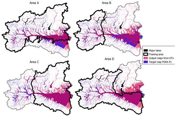
Andrea Magnini, Michele Lombardi, Simone Persiano, Antonio Tirri, Francesco Lo Conti, and Attilio Castellarin
Nat. Hazards Earth Syst. Sci., 22, 1469–1486, https://doi.org/10.5194/nhess-22-1469-2022, https://doi.org/10.5194/nhess-22-1469-2022, 2022
Short summary
Short summary
We retrieve descriptors of the terrain morphology from a digital elevation model of a 105 km2 study area and blend them through decision tree models to map flood susceptibility and expected water depth. We investigate this approach with particular attention to (a) the comparison with a selected single-descriptor approach, (b) the goodness of decision trees, and (c) the performance of these models when applied to data-scarce regions. We find promising pathways for future research.
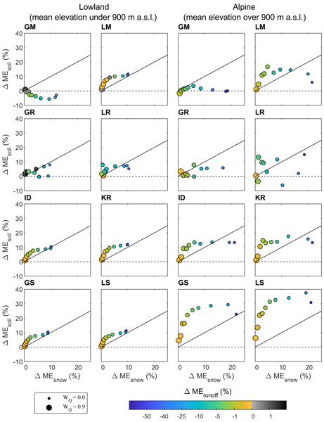
Rui Tong, Juraj Parajka, Borbála Széles, Isabella Greimeister-Pfeil, Mariette Vreugdenhil, Jürgen Komma, Peter Valent, and Günter Blöschl
Hydrol. Earth Syst. Sci., 26, 1779–1799, https://doi.org/10.5194/hess-26-1779-2022, https://doi.org/10.5194/hess-26-1779-2022, 2022
Short summary
Short summary
The role and impact of using additional data (other than runoff) for the prediction of daily hydrographs in ungauged basins are not well understood. In this study, we assessed the model performance in terms of runoff, soil moisture, and snow cover predictions with the existing regionalization approaches. Results show that the best transfer methods are the similarity and the kriging approaches. The performance of the transfer methods differs between lowland and alpine catchments.
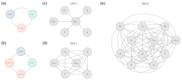
Elisa Ragno, Markus Hrachowitz, and Oswaldo Morales-Nápoles
Hydrol. Earth Syst. Sci., 26, 1695–1711, https://doi.org/10.5194/hess-26-1695-2022, https://doi.org/10.5194/hess-26-1695-2022, 2022
Short summary
Short summary
We explore the ability of non-parametric Bayesian networks to reproduce maximum daily discharge in a given month in a catchment when the remaining hydro-meteorological and catchment attributes are known. We show that a saturated network evaluated in an individual catchment can reproduce statistical characteristics of discharge in about ~ 40 % of the cases, while challenges remain when a saturated network considering all the catchments together is evaluated.
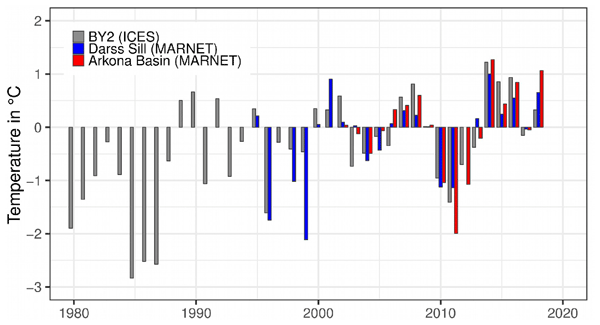
H. E. Markus Meier, Madline Kniebusch, Christian Dieterich, Matthias Gröger, Eduardo Zorita, Ragnar Elmgren, Kai Myrberg, Markus P. Ahola, Alena Bartosova, Erik Bonsdorff, Florian Börgel, Rene Capell, Ida Carlén, Thomas Carlund, Jacob Carstensen, Ole B. Christensen, Volker Dierschke, Claudia Frauen, Morten Frederiksen, Elie Gaget, Anders Galatius, Jari J. Haapala, Antti Halkka, Gustaf Hugelius, Birgit Hünicke, Jaak Jaagus, Mart Jüssi, Jukka Käyhkö, Nina Kirchner, Erik Kjellström, Karol Kulinski, Andreas Lehmann, Göran Lindström, Wilhelm May, Paul A. Miller, Volker Mohrholz, Bärbel Müller-Karulis, Diego Pavón-Jordán, Markus Quante, Marcus Reckermann, Anna Rutgersson, Oleg P. Savchuk, Martin Stendel, Laura Tuomi, Markku Viitasalo, Ralf Weisse, and Wenyan Zhang
Earth Syst. Dynam., 13, 457–593, https://doi.org/10.5194/esd-13-457-2022, https://doi.org/10.5194/esd-13-457-2022, 2022
Short summary
Short summary
Based on the Baltic Earth Assessment Reports of this thematic issue in Earth System Dynamics and recent peer-reviewed literature, current knowledge about the effects of global warming on past and future changes in the climate of the Baltic Sea region is summarised and assessed. The study is an update of the Second Assessment of Climate Change (BACC II) published in 2015 and focuses on the atmosphere, land, cryosphere, ocean, sediments, and the terrestrial and marine biosphere.
Laurène J. E. Bouaziz, Emma E. Aalbers, Albrecht H. Weerts, Mark Hegnauer, Hendrik Buiteveld, Rita Lammersen, Jasper Stam, Eric Sprokkereef, Hubert H. G. Savenije, and Markus Hrachowitz
Hydrol. Earth Syst. Sci., 26, 1295–1318, https://doi.org/10.5194/hess-26-1295-2022, https://doi.org/10.5194/hess-26-1295-2022, 2022
Short summary
Short summary
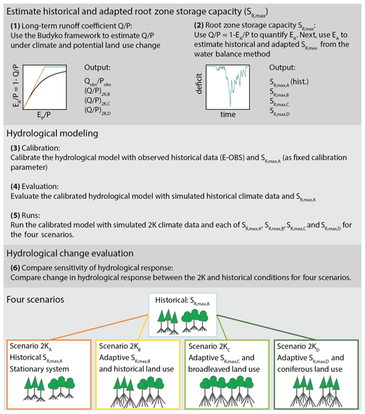
Assuming stationarity of hydrological systems is no longer appropriate when considering land use and climate change. We tested the sensitivity of hydrological predictions to changes in model parameters that reflect ecosystem adaptation to climate and potential land use change. We estimated a 34 % increase in the root zone storage parameter under +2 K global warming, resulting in up to 15 % less streamflow in autumn, due to 14 % higher summer evaporation, compared to a stationary system.
Saúl Arciniega-Esparza, Christian Birkel, Andrés Chavarría-Palma, Berit Arheimer, and José Agustín Breña-Naranjo
Hydrol. Earth Syst. Sci., 26, 975–999, https://doi.org/10.5194/hess-26-975-2022, https://doi.org/10.5194/hess-26-975-2022, 2022
Short summary
Short summary
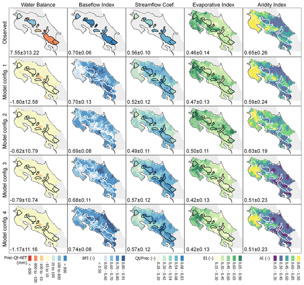
In the humid tropics, a notoriously data-scarce region, we need to find alternatives in order to reasonably apply hydrological models. Here, we tested remotely sensed rainfall data in order to drive a model for Costa Rica, and we evaluated the simulations against evapotranspiration satellite products. We found that our model was able to reasonably simulate the water balance and streamflow dynamics of over 600 catchments where the satellite data helped to reduce the model uncertainties.
Remko C. Nijzink, Jason Beringer, Lindsay B. Hutley, and Stanislaus J. Schymanski
Geosci. Model Dev., 15, 883–900, https://doi.org/10.5194/gmd-15-883-2022, https://doi.org/10.5194/gmd-15-883-2022, 2022
Short summary
Short summary
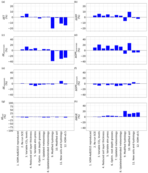
The Vegetation Optimality Model (VOM) is a coupled water–vegetation model that predicts vegetation properties rather than determines them based on observations. A range of updates to previous applications of the VOM has been made for increased generality and improved comparability with conventional models. This showed that there is a large effect on the simulated water and carbon fluxes caused by the assumption of deep groundwater tables and updated soil profiles in the model.
Remko C. Nijzink, Jason Beringer, Lindsay B. Hutley, and Stanislaus J. Schymanski
Hydrol. Earth Syst. Sci., 26, 525–550, https://doi.org/10.5194/hess-26-525-2022, https://doi.org/10.5194/hess-26-525-2022, 2022
Short summary
Short summary
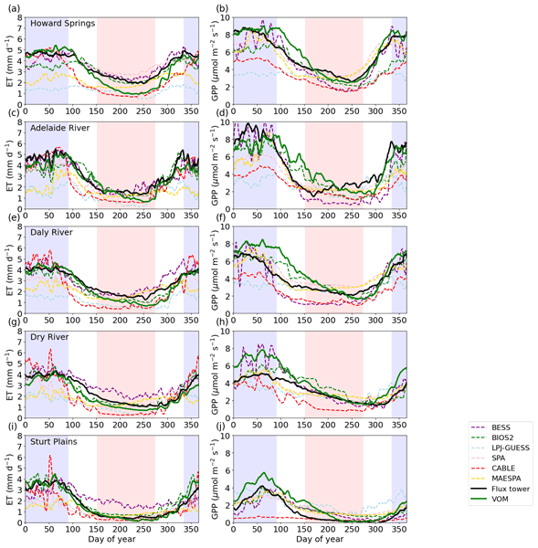
Most models that simulate water and carbon exchanges with the atmosphere rely on information about vegetation, but optimality models predict vegetation properties based on general principles. Here, we use the Vegetation Optimality Model (VOM) to predict vegetation behaviour at five savanna sites. The VOM overpredicted vegetation cover and carbon uptake during the wet seasons but also performed similarly to conventional models, showing that vegetation optimality is a promising approach.
Tom Gleeson, Thorsten Wagener, Petra Döll, Samuel C. Zipper, Charles West, Yoshihide Wada, Richard Taylor, Bridget Scanlon, Rafael Rosolem, Shams Rahman, Nurudeen Oshinlaja, Reed Maxwell, Min-Hui Lo, Hyungjun Kim, Mary Hill, Andreas Hartmann, Graham Fogg, James S. Famiglietti, Agnès Ducharne, Inge de Graaf, Mark Cuthbert, Laura Condon, Etienne Bresciani, and Marc F. P. Bierkens
Geosci. Model Dev., 14, 7545–7571, https://doi.org/10.5194/gmd-14-7545-2021, https://doi.org/10.5194/gmd-14-7545-2021, 2021
Short summary
Short summary
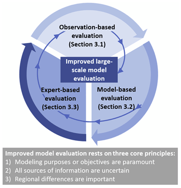
Groundwater is increasingly being included in large-scale (continental to global) land surface and hydrologic simulations. However, it is challenging to evaluate these simulations because groundwater is
hiddenunderground and thus hard to measure. We suggest using multiple complementary strategies to assess the performance of a model (
model evaluation).
Xichao Gao, Zhiyong Yang, Dawei Han, Kai Gao, and Qian Zhu
Hydrol. Earth Syst. Sci., 25, 6023–6039, https://doi.org/10.5194/hess-25-6023-2021, https://doi.org/10.5194/hess-25-6023-2021, 2021
Short summary
Short summary
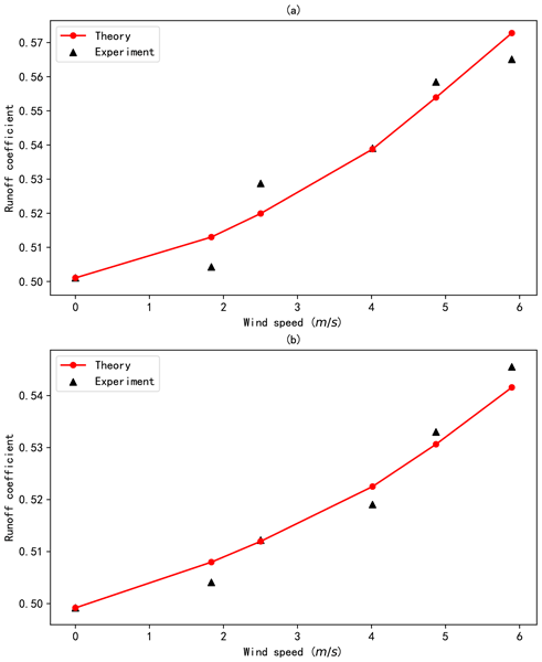
We proposed a theoretical framework and conducted a laboratory experiment to understand the relationship between wind and the rainfall–runoff process in urban high-rise building areas. The runoff coefficient (relating the amount of runoff to the amount of precipitation received) found in the theoretical framework was close to that found in the laboratory experiment.
Wouter Dorigo, Irene Himmelbauer, Daniel Aberer, Lukas Schremmer, Ivana Petrakovic, Luca Zappa, Wolfgang Preimesberger, Angelika Xaver, Frank Annor, Jonas Ardö, Dennis Baldocchi, Marco Bitelli, Günter Blöschl, Heye Bogena, Luca Brocca, Jean-Christophe Calvet, J. Julio Camarero, Giorgio Capello, Minha Choi, Michael C. Cosh, Nick van de Giesen, Istvan Hajdu, Jaakko Ikonen, Karsten H. Jensen, Kasturi Devi Kanniah, Ileen de Kat, Gottfried Kirchengast, Pankaj Kumar Rai, Jenni Kyrouac, Kristine Larson, Suxia Liu, Alexander Loew, Mahta Moghaddam, José Martínez Fernández, Cristian Mattar Bader, Renato Morbidelli, Jan P. Musial, Elise Osenga, Michael A. Palecki, Thierry Pellarin, George P. Petropoulos, Isabella Pfeil, Jarrett Powers, Alan Robock, Christoph Rüdiger, Udo Rummel, Michael Strobel, Zhongbo Su, Ryan Sullivan, Torbern Tagesson, Andrej Varlagin, Mariette Vreugdenhil, Jeffrey Walker, Jun Wen, Fred Wenger, Jean Pierre Wigneron, Mel Woods, Kun Yang, Yijian Zeng, Xiang Zhang, Marek Zreda, Stephan Dietrich, Alexander Gruber, Peter van Oevelen, Wolfgang Wagner, Klaus Scipal, Matthias Drusch, and Roberto Sabia
Hydrol. Earth Syst. Sci., 25, 5749–5804, https://doi.org/10.5194/hess-25-5749-2021, https://doi.org/10.5194/hess-25-5749-2021, 2021
Short summary
Short summary
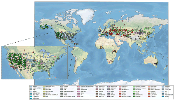
The International Soil Moisture Network (ISMN) is a community-based open-access data portal for soil water measurements taken at the ground and is accessible at https://ismn.earth. Over 1000 scientific publications and thousands of users have made use of the ISMN. The scope of this paper is to inform readers about the data and functionality of the ISMN and to provide a review of the scientific progress facilitated through the ISMN with the scope to shape future research and operations.
David Lun, Alberto Viglione, Miriam Bertola, Jürgen Komma, Juraj Parajka, Peter Valent, and Günter Blöschl
Hydrol. Earth Syst. Sci., 25, 5535–5560, https://doi.org/10.5194/hess-25-5535-2021, https://doi.org/10.5194/hess-25-5535-2021, 2021
Short summary
Short summary
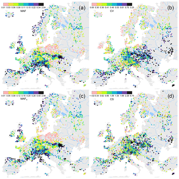
We investigate statistical properties of observed flood series on a European scale. There are pronounced regional patterns, for instance: regions with strong Atlantic influence show less year-to-year variability in the magnitude of observed floods when compared with more arid regions of Europe. The hydrological controls on the patterns are quantified and discussed. On the European scale, climate seems to be the dominant driver for the observed patterns.
Cited articles
Andreassian, V., Hall, A., Chahinian, N., and Schaake, J.: Large Sample Basin Experiments for Hydrological Model Parameterization: Results of the Model Parameter Experiment – MOPEX – IAHS Proceedings & Reports No. 307, IAHS Press, 2006.
Arheimer, B., Wallman, P., Donnelly, C., Nyström, K., and Pers, C.: E-HypeWeb: Service for Water and Climate Information – and Future Hydrological Collaboration across Europe?, in: Environmental Software Systems. Frameworks of eEnvironment, edited by: Hřebíček, J., Schimak, G., and Denzer, R., Vol. 359 of IFIP Advances in Information and Communication Technology, 657–666, Springer Berlin Heidelberg, https://doi.org/10.1007/978-3-642-22285-6_71, 2011.
Berghuijs, W. R., Woods, R. A., and Hrachowitz, M.: A precipitation shift from snow towards rain leads to a decrease in streamflow, Nat. Clim. Change, 4, 583–586, https://doi.org/10.1038/nclimate2246, 2014.
Bergström, S.: Development and application of a conceptual runoff model for Scandinavian catchments – SMHI Reports RHO No.7, Tech. rep., SMHI, Norrköping, 1976.
Beven, K. J.: Uniqueness of place and process representations in hydrological modelling, Hydrol. Earth Syst. Sci., 4, 203–213, https://doi.org/10.5194/hess-4-203-2000, 2000.
Blöschl, G., Sivapalan, M., Wagener, T., Viglione, A., and Savenije, H.: Runoff Predicitons in Ungauged Basins – Synthesis Across Processes, Places and Scales, Cambridge University Press, Cambridge, UK, 2013.
Breuer, L., Huisman, J. A., Willems, P., Bormann, H., Bronstert, A., Croke, B. F. W., Frede, H. G., Graeff, T., Hubrechts, L., Jakeman, A. J., Kite, G., Lanini, J., Leavesley, G., Lettenmaier, D. P., Lindstroem, G., Seibert, J., Sivapalan, M., and Viney, N. R.: Assessing the impact of land use change on hydrology by ensemble modeling (LUCHEM). I: Model intercomparison with current land use, Adv. Water Resour., 32, 129–146, https://doi.org/10.1016/j.advwatres.2008.10.003, 2009.
Ceola, S., Laio, F., and Montanari, A.: Satellite nighttime lights reveal increasing human exposure to floods worldwide, Geophys. Res. Lett., 41, 7184–7190, https://doi.org/10.1002/2014GL061859, 2014.
Ceola, S., Hoedl, I., Adlboller, M., Singer, G., Bertuzzo, E., Mari, L., Botter, G., Waringer, J., Battin, T. J., and Rinaldo, A.: Hydrologic Variability Affects Invertebrate Grazing on Phototrophic Biofilms in Stream Microcosms, PLoS ONE, 8, e60629, https://doi.org/10.1371/journal.pone.0060629, 2013.
Ceola, S., Bertuzzo, E., Singer, G., Battin, T. J., Montanari, A., and Rinaldo, A.: Hydrologic controls on basin- scale distribution of benthic invertebrates, Water Resour. Res., 50, 2903–2920, https://doi.org/10.1002/2013WR015112, 2014a.
Ceola, S., Montanari, A., and Koutsoyiannis, D.: Toward a theoretical framework for integrated modeling of hydrological change, WIREs Water, 41, 427–438, https://doi.org/10.1002/wat2.1038, 2014b.
Clark, M. P., Kavetski, D., and Fenicia, F.: Pursuing the method of multiple working hypotheses for hydrological modeling, Water Resour. Res., 47, W09301, https://doi.org/10.1029/2010WR009827, 2011.
Donnelly, C., Andersson, J., and Arheimer, B.: Using flow signatures and catchment similarities to evaluate the E-HYPE multi-basin model across Europe, J. Hydrol. Sci., https://doi.org/10.1080/02626667.2015.1027710, accepted, 2014.
Duan, Q., Schaake, J., Andréassian, V., Franks, S., Goteti, G., Gupta, H., Gusev, Y., Habets, F., Hall, A., Hay, L., Hogue, T., Huang, M., Leavesley, G., Liang, X., Nasonova, O., Noilhan, J., Oudin, L., Sorooshian, S., Wagener, T., and Wood, E.: Model Parameter Estimation Experiment (MOPEX): An overview of science strategy and major results from the second and third workshops, J. Hydrol., 320, 3–17, https://doi.org/10.1016/j.jhydrol.2005.07.031, 2006.
Falkenmark, M. and Chapman, T.: Comparative hydrology: an ecological approach to land and water resources, UNESCO, Paris, 1989.
Gao, H., Hrachowitz, M., Schymanski, S., Fenicia, F., Sriwongsitanon, N., and Savenije, H.: Climate controls how ecosystems size the root zone storage capacity at catchment scale, Geophys. Res. Lett., 41, 7916–7923, https://doi.org/10.1002/2014GL061668, 2014.
Gudmundsson, L., Wagener, T., Tallaksen, L. M., and Engeland, K.: Evaluation of nine large-scale hydrological models with respect to the seasonal runoff climatology in Europe, Water Resour. Res., 48, W11504, https://doi.org/10.1029/2011WR010911, 2012.
Gupta, H. V., Perrin, C., Blöschl, G., Montanari, A., Kumar, R., Clark, M., and Andréassian, V.: Large-sample hydrology: a need to balance depth with breadth, Hydrol. Earth Syst. Sci., 18, 463–477, https://doi.org/10.5194/hess-18-463-2014, 2014.
Haddeland, I., Heinke, J., Biemans, H., Eisner, S., Floerke, M., Hanasaki, N., Konzmann, M., Ludwig, F., Masaki, Y., Schewe, J., Stacke, T., Tessler, Z. D., Wada, Y., and Wisser, D.: Global water resources affected by human interventions and climate change, P. Natl. Acad. Sci. USA, 111, 3251–3256, https://doi.org/10.1073/pnas.1222475110, 2014.
Holländer, H. M., Blume, T., Bormann, H., Buytaert, W., Chirico, G. B., Exbrayat, J.-F., Gustafsson, D., Hölzel, H., Kraft, P., Stamm, C., Stoll, S., Blöschl, G., and Flühler, H.: Comparative predictions of discharge from an artificial catchment (Chicken Creek) using sparse data, Hydrol. Earth Syst. Sci., 13, 2069–2094, https://doi.org/10.5194/hess-13-2069-2009, 2009.
Holländer, H. M., Bormann, H., Blume, T., Buytaert, W., Chirico, G. B., Exbrayat, J.-F., Gustafsson, D., Hölzel, H., Krauße, T., Kraft, P., Stoll, S., Blöschl, G., and Flühler, H.: Impact of modellers' decisions on hydrological a priori predictions, Hydrol. Earth Syst. Sci., 18, 2065–2085, https://doi.org/10.5194/hess-18-2065-2014, 2014.
Hrachowitz, M., Savenije, H. H. G., Blöschl, G., McDonnell, J. J., Sivapalan, M., Pomeroy, J. W., Arheimer, B., Blume, T., Clark, M. P., Ehret, U., Fenicia, F., Freer, J. E., Gelfan, A., Gupta, H. V., Hughes, D. A., Hut, R. W., Montanari, A., Pande, S., Tetzlaff, D., Troch, P. A., Uhlenbrook, S., Wagener, T., Winsemius, H. C., Woods, R. A., Zehe, E., and Cudennec, C.: A decade of Predictions in Ungauged Basins (PUB) a review, Hydrol. Sci. J., 58, 1198–1255, https://doi.org/10.1080/02626667.2013.803183, 2013.
Jakeman, A., Letcher, R., and Norton, J.: Ten iterative steps in development and evaluation of environmental models, Environ. Modell. Softw., 21, 602–614, https://doi.org/10.1016/j.envsoft.2006.01.004, 2006.
Jongman, B., Kreibich, H., Apel, H., Barredo, J. I., Bates, P. D., Feyen, L., Gericke, A., Neal, J., Aerts, J. C. J. H., and Ward, P. J.: Comparative flood damage model assessment: towards a European approach, Nat. Hazards Earth Syst. Sci., 12, 3733–3752, https://doi.org/10.5194/nhess-12-3733-2012, 2012.
Koutsoyiannis, D. and Montanari, A.: Negligent killing of scientific concepts: the stationarity case, Hydrol. Sci. J., https://doi.org/10.1080/02626667.2014.959959, 2014.
Merz, R., Parajka, J., and Blöschl, G.: Time stability of catchment model parameters: Implications for climate impact analyses, Water Resour. Res., 47, W02531, https://doi.org/10.1029/2010WR009505, 2011.
Milly, P. C. D., Betancourt, J., Falkenmark, M., Hirsch, R. M., Kundzewicz, Z. W., Lettenmaier, D. P., and Stouffer, R. J.: Climate change – Stationarity is dead: Whither water management?, Science, 319, 573–574, https://doi.org/10.1126/science.1151915, 2008.
Montanari, A. and Koutsoyiannis, D.: A blueprint for process-based modeling of uncertain hydrological systems, Water Resour. Res., 48, W09555, https://doi.org/10.1029/2011WR011412, 2012.
Montanari, A. and Koutsoyiannis, D.: Reply to comment by Grey Nearing on "A blueprint for process-based modeling of uncertain hydrological systems", Water Resour. Res., 50, 6264–6268, https://doi.org/10.1002/2013WR014987, 2014a.
Montanari, A. and Koutsoyiannis, D.: Modeling and Mitigating Natural Hazards: Stationarity is Immortal!, Water Resour. Res., 50, 9748–9756, https://doi.org/10.1002/2014WR016092, 2014b.
Montanari, A., Shoemaker, C. A., and van de Giesen, N.: Introduction to special section on Uncertainty Assessment in Surface and Subsurface Hydrology: An overview of issues and challenges, Water Resour. Res., 45, W00B00, https://doi.org/10.1029/2009WR008471, 2009.
Montanari, A., Young, G., Savenije, H. H. G., Hughes, D., Wagener, T., Ren, L. L., Koutsoyiannis, D., Cudennec, C., Toth, E., Grimaldi, S., Blöschl, G., Sivapalan, M., Beven, K., Gupta, H., Hipsey, M., Schaefli, B., Arheimer, B., Boegh, E., Schymanski, S. J., Di Baldassarre, G., Yu, B., Hubert, P., Huang, Y., Schumann, A., Post, D. A., Srinivasan, V., Harman, C., Thompson, S., Rogger, M., Viglione, A., McMillan, H., Characklis, G., Pang, Z., and Belyaev, V.: "Panta Rhei-Everything Flows": Change in hydrology and society-The IAHS Scientific Decade 2013–2022, Hydrol. Scie. J., 58, 1256–1275, https://doi.org/10.1080/02626667.2013.809088, 2013.
Moretti, G. and Montanari, A.: Inferring the flood frequency distribution for an ungauged basin using a spatially distributed rainfall-runoff model, Hydrol. Earth Syst. Sci., 12, 1141–1152, https://doi.org/10.5194/hess-12-1141-2008, 2008.
Mullen, K. M., Ardia, D., Gil, D. L., Windover, D., and Cline, J.: DEoptim: An R Package for Global Optimization by Differential Evolution, J. Stat. Softw., 40, 1–26, 2011.
Parajka, J. and Viglione, A.: TUWmodel: Lumped hydrological model developed at the Vienna University of Technology for education purposes, R package version 0.1-2., available at: http://CRAN.R-project.org/package=TUWmodel (last access: 20 October 2014), 2012.
Parajka, J., Merz, R., and Blöschl, G.: Estimation of daily potential evapotranspiration for regional water balance modeling in Austria, in: 11th International Poster Day and Institute of Hydrology Open Day – Transport of Water, Chemicals and Energy in the Soil – Crop Canopy – Atmosphere System, 299–306, Slovak Academy of Sciences, Bratislava, 2003.
Parajka, J., Merz, R., and Blöschl, G.: Uncertainty and multiple objective calibration in regional water balance modelling: case study in 320 Austrian catchments, Hydrol. Process., 21, 435–446, https://doi.org/10.1002/hyp.6253, 2007.
Parajka, J., Viglione, A., Rogger, M., Salinas, J. L., Sivapalan, M., and Blöschl, G.: Comparative assessment of predictions in ungauged basins – Part 1: Runoff-hydrograph studies, Hydrol. Earth Syst. Sci., 17, 1783–1795, https://doi.org/10.5194/hess-17-1783-2013, 2013.
Parsons, A. J., Abrahams, A. D., and Wainwright, J.: On determining resistance to interrill overland-flow, Water Resour. Res., 30, 3515–3521, https://doi.org/10.1029/94WR02176, 1994.
R Core Team: R: A Language and Environment for Statistical Computing, R Foundation for Statistical Computing, Vienna, Austria, available at: http://www.R-project.org/, last access: 5 September 2014.
Ramasundaram, V., Grunwald, S., Mangeot, A., Comerford, N., and Bliss, C.: Development of an environmental virtual field laboratory, Comput. Educ., 45, 21–34, https://doi.org/10.1016/j.compedu.2004.03.002, 2005.
Reed, S., Koren, V., Smith, M., Zhang, Z., Moreda, F., Seo, D., and Participants, D.: Overall distributed model intercomparison project results, J. Hydrol., 298, 27–60, https://doi.org/10.1016/j.jhydrol.2004.03.031, 2004.
Refsgaard, J., Henriksen, H., Harrar, W., Scholten, H., and Kassahun, A.: Quality assurance in model based water management – review of existing practice and outline of new approaches, Environ. Modell. Softw., 20, 1201–1215, https://doi.org/10.1016/j.envsoft.2004.07.006, 2005.
Rinaldo, A., Bertuzzo, E., Mari, L., Righetto, L., Blokesch, M., Gatto, M., Casagrandi, R., Murray, M., Vesenbeckh, S. M., and Rodriguez-Iturbe, I.: Reassessment of the 2010–2011 Haiti cholera outbreak and rainfall-driven multiseason projections, P. Natl. Acad. Sci. USA, 109, 6602–6607, https://doi.org/10.1073/pnas.1203333109, 2012.
Schewe, J., Heinke, J., Gerten, D., Haddeland, I., Arnell, N. W., Clark, D. B., Dankers, R., Eisner, S., Fekete, B. M., Colon-Gonzalez, F. J., Gosling, S. N., Kim, H., Liu, X., Masaki, Y., Portmann, F. T., Satoh, Y., Stacke, T., Tang, Q., Wada, Y., Wisser, D., Albrecht, T., Frieler, K., Piontek, F., Warszawski, L., and Kabat, P.: Multimodel assessment of water scarcity under climate change, P. Natl. Acad. Sci. USA, 111, 3245–3250, https://doi.org/10.1073/pnas.1222460110, 2014.
UNISDR: From Shared Risk to Shared Value – The Business Case for Disaster Risk Reduction. Global Assessment Report on Disaster Risk Reduction, Tech. rep., UNISDR, Geneva, 2013.
Viglione, A., Borga, M., Balabanis, P., and Blöschl, G.: Barriers to the exchange of hydrometeorological data in Europe Results from a survey and implications for data policy, J. Hydrol., 394, 63–77, https://doi.org/10.1016/j.jhydrol.2010.03.023, 2010.
Wagener, T., Sivapalan, M., Troch, P. A., and Woods, R.: Catchment Classification and Hydrologic Similarity, Geogr. Compass, 1, 901–931, https://doi.org/10.1111/j.1749-8198.2007.00039.x, 2007.
Wagener, T., Sivapalan, M., Troch, P. A., McGlynn, B. L., Harman, C. J., Gupta, H. V., Kumar, P., Rao, P. S. C., Basu, N. B., and Wilson, J. S.: The future of hydrology: An evolving science for a changing world, Water Resour. Res., 46, W05301, https://doi.org/10.1029/2009WR008906, 2010.
Ward, P., Jongman, B., Weiland, F., Bouwman, A., van Beek, R., Bierkens, M., Ligtvoet, W., and Winsemius, H.: Assessing flood risk at the global scale: model setup, results, and sensitivity, Environ. Res. Lett., 8, 044019, https://doi.org/10.1088/1748-9326/8/4/044019, 2013.
WMO: Intercomparison of models of snowmelt runoff. Operational Hydrology Report No. 23, WMO-No. 646, Tech. rep., WMO, Geneva, 1986.
WMO: Simulated Real-time Intercomparison of Hydrological Models. Operational Hydrology Report No. 38, Tech. rep., WMO, Geneva, 1992.
World Water Assessment Programme: The United Nations World Water Development Report 4: Managing Water under Uncertainty and Risk, Tech. rep., UNESCO, Paris, 2012.
Short summary
We present the outcomes of a collaborative hydrological experiment undertaken by five different international research groups in a virtual laboratory. Moving from the definition of accurate protocols, a rainfall-runoff model was independently applied by the research groups, which then engaged in a comparative discussion. The results revealed that sharing protocols and running the experiment within a controlled environment is fundamental for ensuring experiment repeatability and reproducibility.
We present the outcomes of a collaborative hydrological experiment undertaken by five different...


