
Articles | Volume 23, issue 1
https://doi.org/10.5194/hess-23-465-2019
© Author(s) 2019. This work is distributed under
the Creative Commons Attribution 4.0 License.
the Creative Commons Attribution 4.0 License.
https://doi.org/10.5194/hess-23-465-2019
© Author(s) 2019. This work is distributed under
the Creative Commons Attribution 4.0 License.
the Creative Commons Attribution 4.0 License.
Research article
| 
25 Jan 2019
Research article |
| 25 Jan 2019
| 25 Jan 2019
Integrating multiple satellite observations into a coherent dataset to monitor the full water cycle – application to the Mediterranean region
Laboratoire d'Études du Rayonnement et de la Matière en Astrophysique et Atmosphères, Observatoire de Paris, Paris, France
Estellus, Paris, France
Filipe Aires
Laboratoire d'Études du Rayonnement et de la Matière en Astrophysique et Atmosphères, Observatoire de Paris, Paris, France
Estellus, Paris, France
Simon Munier
Centre National de Recherches Météorologiques, Toulouse, France
Diego Fernández Prieto
European Space Agency, Frascati, Italy
Gabriel Jordá
Institut Mediterrani d'Estudis Avançats, University of the Balearic Islands, Mallorca, Spain
Wouter Arnoud Dorigo
Department of Geodesy and Geoinformation, Technical University, Vienna, Austria
Jan Polcher
Laboratoire de Météorologie Dynamique, Paris, France
Luca Brocca
Istituto di Ricerca per la Protezione Idrogeologica, Perugia, Italy
Related authors
Marie Bouillon, Sarah Safieddine, Simon Whitburn, Lieven Clarisse, Filipe Aires, Victor Pellet, Olivier Lezeaux, Noëlle A. Scott, Marie Doutriaux-Boucher, and Cathy Clerbaux
Atmos. Meas. Tech., 15, 1779–1793, https://doi.org/10.5194/amt-15-1779-2022, https://doi.org/10.5194/amt-15-1779-2022, 2022
Short summary
Short summary
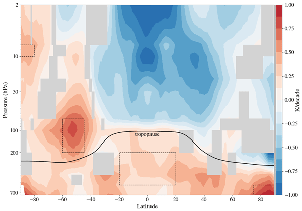
The IASI instruments have been observing Earth since 2007. We use a neural network to retrieve atmospheric temperatures. This new temperature data record is validated against other datasets and shows good agreement. We use this new dataset to compute trends over the 2008–2020 period. We found a warming of the troposphere, more important at the poles. In the stratosphere, we found that temperatures decrease everywhere except at the South Pole. The cooling is more pronounced at the South pole.
Jawairia A. Ahmad, Christopher M. Taylor, Bethan L. Harris, Dávid D. Kovács, Seonaid Anderson, Adrià Amell, Colin Moldenhauer, Steven Wells, and Wouter Dorigo
EGUsphere, https://doi.org/10.5194/egusphere-2026-4687, https://doi.org/10.5194/egusphere-2026-4687, 2026
This preprint is open for discussion and under review for Hydrology and Earth System Sciences (HESS).
Short summary
Short summary
Evaluating the ability of satellite-observed soil moisture products to represent fine-scale land surface information shows that active microwave radar based product from ASCAT captures spatial variability at fine resolution which passive microwave based products miss. Rainfall dataset evaluation using fine-scale soil moisture information highlights the limitations in ERA5 precipitation. Further, fine-scale soil moisture information improves nowcasting of convective storms over dry regions.
Esmaeel Adrah, Luca Brocca, Emine Senkardesler, and He Yin
Earth Syst. Sci. Data Discuss., https://doi.org/10.5194/essd-2026-603, https://doi.org/10.5194/essd-2026-603, 2026
Preprint under review for ESSD
Short summary
Short summary
The eastern Mediterranean is a hotspot for drought, extreme water scarcity, and geopolitical tension, yet long-term data on irrigation is missing. To address this, we used twenty-six years of satellite imagery to track soil moisture and map winter and summer irrigated lands. This freely available data reveals irrigation changes across the region over time, and support managing scarce water resources, understanding climate impacts, and improving regional food security.
Julien Lefebve, Sylvain Biancamaria, Alejandro Blazquez, Simon Munier, Laetitia Gal, Rômulo Augusto Jucá Oliveira, and Jordi Etchanchu
EGUsphere, https://doi.org/10.5194/egusphere-2026-4569, https://doi.org/10.5194/egusphere-2026-4569, 2026
This preprint is open for discussion and under review for Hydrology and Earth System Sciences (HESS).
Short summary
Short summary
Approaching the water budget closure of a basin gives confidence in our understanding of its water cycle. By analysing 82 major basins worldwide with the most up‑to‑date data, we demonstrate that the large spread in precipitation (44 %), evapotranspiration (33 %) and runoff (36 %) can produce compensations and lead to erroneous conclusions about water budget closure. In the absence of gauge records, calculating discharge from satellite observations rather than from models reduces these errors.
Julia Pfeffer, Benoît Meyssignac, Rory Bingham, Alejandro Blazquez, Marie Bouih, Carla Braitenberg, Luca Brocca, Henryk Dobslaw, Ramiro Ferrari, Ehsan Forootan, Helena Gerdener, Muhammad Tahir Javed, Laura Jensen, Volker Klemann, Anna Kremer, Jürgen Kusche, Gilles Larnicol, Muhammad Usman Liaqat, Francesco Leopardi, Elisavet-Maria Mamagiannou, Gerardo Maurizio, Roland Pail, Isabelle Panet, Thomas Papanikolaou, Peyman Saemian, Ingo Sasgen, Maike Schumacher, Marius Schlaak, Linus Shihora, Alireza Sobouti, Nico Sneeuw, Mohammad Javad Tourian, Dimitrios Tsoulis, Georgios Vergos, Bert Wouters, Fan Yang, and Ilias Daras
EGUsphere, https://doi.org/10.5194/egusphere-2026-4642, https://doi.org/10.5194/egusphere-2026-4642, 2026
This preprint is open for discussion and under review for Earth Observation (EO).
Short summary
Short summary
The ESA SING project demonstrates how the future satellite gravity missions NGGM and MAGIC will improve observations of continental water storage, oceans, glaciers, sea level, earthquakes, and climate change. Their more accurate, higher-resolution gravity measurements will enhance Earth system monitoring, improve climate and hazard assessments, and strengthen operational services for water management, disaster preparedness, and environmental decision-making.
Muhammad Usman Liaqat, Stefania Camici, Francesco Leopardi, Jaime Gaona, and Luca Brocca
Hydrol. Earth Syst. Sci., 30, 4969–4983, https://doi.org/10.5194/hess-30-4969-2026, https://doi.org/10.5194/hess-30-4969-2026, 2026
Short summary
Short summary
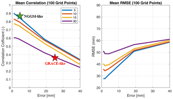
Tracking land water storage helps examine extreme events and manage water resources. GRACE (Gravity Recovery and Climate Experiment) missions observe changes, but coarse resolution in space and time challenges effective management. New gravity mission called MAGIC (Mass Change And Geosciences International Constellation) can offers better accuracy. This study tested MAGIC’s potential to estimate precipitation using the SM2RAIN approach. Results show SM2RAIN works well with frequent, accurate data but deteriorates with noisy/sparse data, emphasizing the need for precise gravity missions.
Man Chen, Philippe Ciais, Gustaf Hugelius, and Filipe Aires
Earth Syst. Sci. Data Discuss., https://doi.org/10.5194/essd-2026-254, https://doi.org/10.5194/essd-2026-254, 2026
Preprint under review for ESSD
Short summary
Short summary
Peatlands are vital carbon stores, yet mapping them consistently across borders is challenging due to varying data quality and definitions. We developed PeatCover, a ~90 m resolution map that harmonizes existing inventories with Earth observation and hydro-topographic data through machine learning. PeatCover provides a spatially coherent dataset that resolves fine landscape structures. These improvements enable refined carbon assessments and methane emission models.
Pierre Laluet, Jacopo Dari, Louise Busschaert, Zdenko Heyvaert, Gabrielle De Lannoy, Pia Langhans, Sara Modanesi, Christian Massari, Luca Brocca, Carla Saltalippi, Renato Morbidelli, Clément Albergel, and Wouter Dorigo
Earth Syst. Sci. Data, 18, 4833–4853, https://doi.org/10.5194/essd-18-4833-2026, https://doi.org/10.5194/essd-18-4833-2026, 2026
Short summary
Short summary
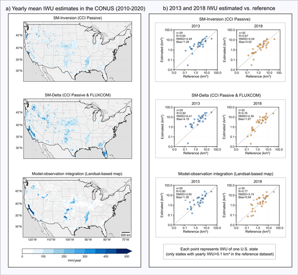
We developed a long-term dataset collection of irrigation water use based on about two decades of satellite observations, three distinct approaches, and many input datasets. The collection provides monthly estimates for major agricultural regions and helps describe how irrigation varies across locations, seasons, and years. It offers a foundation for improving how irrigation is quantified, compared across methods, and integrated into large-scale hydrological and climate studies.
Francesco Avanzi, Hans Lievens, Michael Matiu, Paolo Filippucci, Oscar M. Baez Villanueva, Simone Gabellani, Fabio Delogu, Lorenzo Alfieri, Andrea Libertino, Pere Quintana-Seguì, Diego G. Miralles, Luca Brocca, Christian Massari, and Gabriëlle J. M. De Lannoy
EGUsphere, https://doi.org/10.5194/egusphere-2026-2851, https://doi.org/10.5194/egusphere-2026-2851, 2026
Short summary
Short summary
We developed a new system to map and monitor snow and stored water across large mountain regions using satellite data and computer simulations. Tested in four major European river basins, the system reproduced snow conditions with high accuracy and realistically captured how snow changes with elevation. Because it does not rely on ground measurements, it can help provide consistent information on snow-water resources worldwide, supporting water management and climate adaptation.
Ather Abbas, Yuan Yang, Ming Pan, Yves Tramblay, Chaopeng Shen, Haoyu Ji, Solomon H. Gebrechorkos, Florian Pappenberger, JongCheol Pyo, Dapeng Feng, George Huffman, Phu Nguyen, Christian Massari, Luca Brocca, Jackson Tan, and Hylke E. Beck
Hydrol. Earth Syst. Sci., 30, 3399–3423, https://doi.org/10.5194/hess-30-3399-2026, https://doi.org/10.5194/hess-30-3399-2026, 2026
Short summary
Short summary
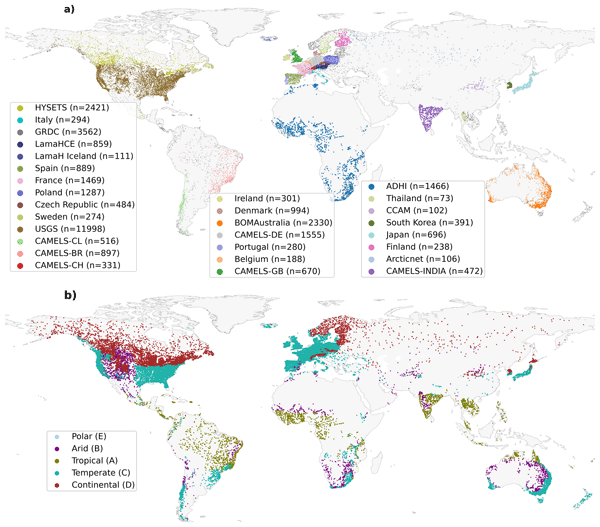
Our study evaluated 24 precipitation datasets using a hydrological model at global scale to assess their suitability and accuracy. We found that MSWEP (Multi-Source Weighted-Ensemble Precipitation) V2.8 excels due to its ability to integrate data from multiple sources, while others, such as IMERG (Integrated Multi-satellitE Retrievals for Global Precipitation Mission) and GDAS (Global Data Assimilation System), demonstrated strong regional performances. This research assists in selecting the appropriate dataset for applications in water resource management, hazard assessment, agriculture, and environmental monitoring.
Peyman Afrasiabikia, Atefeh Parvaresh Rizi, and Luca Brocca
ISPRS Ann. Photogramm. Remote Sens. Spatial Inf. Sci., X-4-W8-2025, 33–38, https://doi.org/10.5194/isprs-annals-X-4-W8-2025-33-2026, https://doi.org/10.5194/isprs-annals-X-4-W8-2025-33-2026, 2026
Adrien Manlay, Jean-Pierre Vergnes, Simon Munier, and Florence Habets
EGUsphere, https://doi.org/10.5194/egusphere-2026-1504, https://doi.org/10.5194/egusphere-2026-1504, 2026
Short summary
Short summary
Groundwater is a key resource for human activities, predicting its evolution months in advance poses a significant challenge. Forecasts can be erroneous due to model uncertainties. In this study, we developed a method that integrates observed groundwater levels into a numerical model to improve seasonal forecasts. By continuously updating the model with observations, we achieved more accurate water level simulations and predictions up to six months ahead.
Lan Anh Dinh, Filipe Aires, and Victor Pellet
EGUsphere, https://doi.org/10.5194/egusphere-2026-2360, https://doi.org/10.5194/egusphere-2026-2360, 2026
Short summary
Short summary
Soil moisture (SM) plays a key role in weather, agriculture, and water management. While satellites can measure SM from space, obtaining accurate, frequent measurements throughout the day remains challenging. Here, we explore how deep learning models can improve sub-daily SM estimates. Our approach focuses on capturing spatial patterns and adapting to local conditions. Using data from the ASCAT satellite instrument, we show that this model can produce reliable SM estimates multiple times a day.
Eric Sauquet, Guillaume Evin, Sonia Siauve, Ryma Aissat, Patrick Arnaud, Maud Bérel, Jérémie Bonneau, Flora Branger, Yvan Caballero, François Colléoni, Agnès Ducharne, Joël Gailhard, Florence Habets, Frédéric Hendrickx, Louis Héraut, Benoît Hingray, Peng Huang, Tristan Jaouen, Alexis Jeantet, Sandra Lanini, Matthieu Le Lay, Claire Magand, Louise Mimeau, Céline Monteil, Simon Munier, Charles Perrin, Olivier Robelin, Fabienne Rousset, Jean-Michel Soubeyroux, Laurent Strohmenger, Guillaume Thirel, Flore Tocquer, Yves Tramblay, Jean-Pierre Vergnes, and Jean-Philippe Vidal
Hydrol. Earth Syst. Sci., 30, 2277–2300, https://doi.org/10.5194/hess-30-2277-2026, https://doi.org/10.5194/hess-30-2277-2026, 2026
Short summary
Short summary
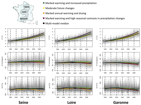
The Explore2 project has provided an unprecedented set of hydrological projections in terms of the number of hydrological models used and the spatial and temporal resolution. The results have been made available through various media. Under the high-emission scenario, the hydrological models mostly agree on the decrease in seasonal flows in the south of France, confirming its hotspot status, and on the decrease in summer flows throughout France, with the exception of the northern part of France.
Oscar M. Baez-Villanueva, Alfredo Crespo-Otero, Sara Modanesi, Pierre Laluet, Sergio Vicente-Serrano, Jaap Schellekens, Jacopo Dari, Hylke E. Beck, Wouter Dorigo, Christian Massari, Chiara Corbari, Joppe Massant, Kwint Delbare, Olivier Bonte, Aaron Boone, Diego Fernández-Prieto, and Diego G. Miralles
EGUsphere, https://doi.org/10.5194/egusphere-2026-1856, https://doi.org/10.5194/egusphere-2026-1856, 2026
Short summary
Short summary
We developed a new method to estimate daily land evaporation at high resolution across the Iberian Peninsula, explicitly accounting for irrigation. By combining satellite and meteorological data, we show that irrigation can strongly increase evaporation in agricultural areas. The results better match ground observations and improve understanding of water use. This approach can support farming decisions and water management at the regional scale, and will be extended to global applications.
Ehsan Modiri, Oldrich Rakovec, Pallav Kumar Shrestha, Almudena García-García, Leandro Avila, Katie Blackford, Elizabeth Cooper, Bram Droppers, Paolo Filippucci, Milan Fischer, Matěj Orság, Pietro Stradiotti, Luca Brocca, Douglas B. Clark, Wouter Dorigo, Stefan Kollet, Jian Peng, Niko Wanders, and Luis Samaniego
EGUsphere, https://doi.org/10.5194/egusphere-2026-1012, https://doi.org/10.5194/egusphere-2026-1012, 2026
Short summary
Short summary
Drought impacts water supply, agriculture, and ecosystems, yet hydrological models often disagree on when and where drought occurs. This study tested whether satellite observations can improve how models represent soil moisture drought in the Rhine River basin. Using several models and major drought events, we show that satellite data improve spatial realism and reveal important differences among models, helping to better understand uncertainty in drought monitoring and early warning.
Pierre Laluet, Chiara Corbari, Oscar Baez-Villanueva, Sophia Walther, Yongqiang Zhang, Joaquín Muñoz-Sabater, Clément Albergel, and Wouter Dorigo
Hydrol. Earth Syst. Sci., 30, 1779–1799, https://doi.org/10.5194/hess-30-1779-2026, https://doi.org/10.5194/hess-30-1779-2026, 2026
Short summary
Short summary
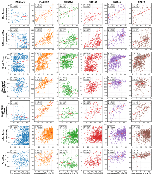
We examined how well global datasets estimate evapotranspiration, the water moving from land to the air, in irrigated areas. We compared six widely used products with irrigation maps, satellite estimates, and field measurements across different climate regions. Some datasets better capture irrigation effects, especially those using temperature and vegetation satellite data. This work helps guide dataset selection and supports better inclusion of irrigation in hydrological and climate models.
Roland Hohensinn, Junyang Gou, Ulrich Meyer, Vincent Humphrey, Wouter Dorigo, Eva Boergens, Benedikt Soja, Alexander Gruber, Laura Jensen, Annette Eicker, Michael Rast, and Andreas Güntner
EGUsphere, https://doi.org/10.5194/egusphere-2026-975, https://doi.org/10.5194/egusphere-2026-975, 2026
Short summary
Short summary
This study provides a statistically traceable, uncertainty-aware assessment of global terrestrial and groundwater storage trends based on 21.5 years of GRACE/-FO observations using the Global Gravity-based Groundwater Product (G3P). By accounting for long-range memory and interannual variability, we isolate robust trends from climate variability and noise. The analysis refines continental budgets and identifies emerging groundwater gains alongside widespread persistent decline.
Guillaume Evin, Benoit Hingray, Guillaume Thirel, Agnès Ducharne, Laurent Strohmenger, Lola Corre, Yves Tramblay, Jean-Philippe Vidal, Jérémie Bonneau, François Colleoni, Joël Gailhard, Florence Habets, Frédéric Hendrickx, Louis Héraut, Peng Huang, Matthieu Le Lay, Claire Magand, Paola Marson, Céline Monteil, Simon Munier, Alix Reverdy, Jean-Michel Soubeyroux, Yoann Robin, Jean-Pierre Vergnes, Mathieu Vrac, and Eric Sauquet
Hydrol. Earth Syst. Sci., 30, 1023–1051, https://doi.org/10.5194/hess-30-1023-2026, https://doi.org/10.5194/hess-30-1023-2026, 2026
Short summary
Short summary
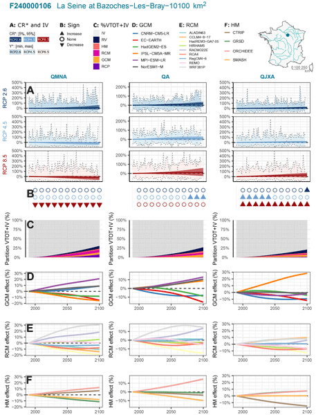
Explore2 provides hydrological projections for 1,735 French catchments. Using QUALYPSO (Quasi-Ergodic Analysis of Climate Projections Using Data Augmentation), this study assesses uncertainties, including internal variability. By the end of the century, low flows are projected to decline in southern France under high emissions, while other indicators remain uncertain. Emission scenarios and regional climate models are key uncertainty sources. Internal variability is often as large as climate-driven changes.
Kaushlendra Verma and Simon Munier
EGUsphere, https://doi.org/10.5194/egusphere-2026-509, https://doi.org/10.5194/egusphere-2026-509, 2026
Short summary
Short summary
Satellite provide river observations as vector reaches, while large-scale hydrological models represent rivers on gridded routing networks. This structural mismatch limits direct data assimilation. We present a global, confidence-aware framework that assigns vector river reaches to routing pixels using geometric and hydrological consistency criteria. Results show that most routing pixels can be assigned with high confidence while preserving basin-scale drainage topology into hydrological models.
Andreas Güntner, Ehsan Sharifi, Julian Haas, Eva Boergens, Feifei Cao, Christoph Dahle, Neda Darbeheshti, Henryk Dobslaw, Inés Dussaillant, Wouter Dorigo, Frank Flechtner, Adrian Jäggi, Miriam Kosmale, Martin Lasser, Kari Luojus, Ulrich Meyer, Adam Pasik, Wolfgang Preimersberger, Claudia Ruz Vargas, and Michael Zemp
Earth Syst. Sci. Data Discuss., https://doi.org/10.5194/essd-2025-797, https://doi.org/10.5194/essd-2025-797, 2026
Revised manuscript under review for ESSD
Short summary
Short summary
We provide a data set that illustrates how the amount of water that is stored in the subsurface as groundwater varies in time over the continents of the Earth. A main source of the data are observations with satellites that weigh the changing amount of water by its mass attraction effect. The data allow for assessing how groundwater as the most important freshwater resource for mankind and ecosystems is affected by climate variability, climate change and withdrawal by human activities.
Bethan L. Harris, Christopher M. Taylor, Wouter Dorigo, Ruxandra-Maria Zotta, Darren Ghent, and Iván Noguera
Hydrol. Earth Syst. Sci., 29, 6917–6933, https://doi.org/10.5194/hess-29-6917-2025, https://doi.org/10.5194/hess-29-6917-2025, 2025
Short summary
Short summary
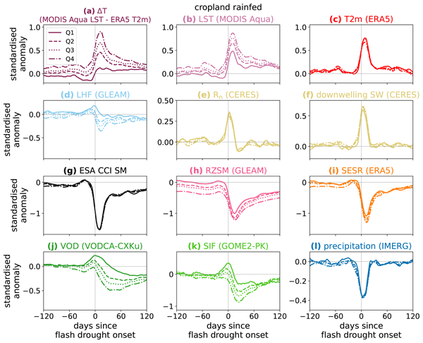
An improved understanding of land-atmosphere coupling processes during flash (rapid-onset) droughts is needed to aid the development of forecasts for these events. We use satellite observations to investigate the surface energy budget during flash droughts globally. The most intense events show a perturbed surface energy budget months before onset. In some regions, vegetation observations 1–2 months before onset provide information on the likelihood of heat extremes during an event.
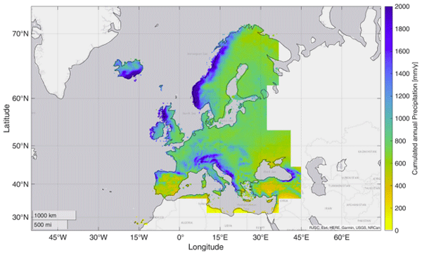
Paolo Filippucci, Luca Brocca, Luca Ciabatta, Hamidreza Mosaffa, Francesco Avanzi, and Christian Massari
Earth Syst. Sci. Data, 17, 5221–5258, https://doi.org/10.5194/essd-17-5221-2025, https://doi.org/10.5194/essd-17-5221-2025, 2025
Short summary
Short summary
Accurate rainfall data is essential, yet measuring daily precipitation worldwide is challenging. This research presents HYdroclimatic PERformance-enhanced Precipitation (HYPER-P), a dataset combining satellite, ground, and reanalysis data to estimate precipitation at a 1 km scale from 2000 to 2022. HYPER-P improves accuracy, especially in areas with few rain gauges. This dataset supports scientists and decision-makers in understanding and managing water resources more effectively.
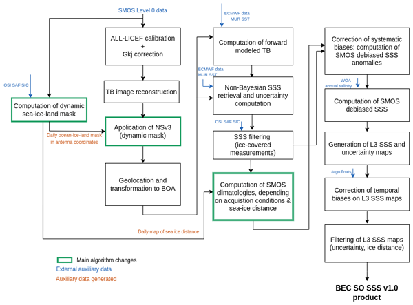
Verónica González-Gambau, Estrella Olmedo, Aina García-Espriu, Cristina González-Haro, Antonio Turiel, Carolina Gabarró, Alessandro Silvano, Aditya Narayanan, Alberto Naveira-Garabato, Rafael Catany, Nina Hoareau, Marta Umbert, Giuseppe Aulicino, Yuri Cotroneo, Roberto Sabia, and Diego Fernández-Prieto
Earth Syst. Sci. Data, 17, 5089–5111, https://doi.org/10.5194/essd-17-5089-2025, https://doi.org/10.5194/essd-17-5089-2025, 2025
Short summary
Short summary
This paper introduces a new Sea Surface Salinity product for the Southern Ocean, based on SMOS data and developed by the Barcelona Expert Center. It offers 9 d maps on a 25 km EASE-SL grid, from 2011 to 2023, covering areas south of 30° S. The product is accurate beyond 150 km from sea ice, with nearly zero bias and a ~0.22 STD. It tracks well seasonal and interannual changes and will contribute to the understanding of processes influenced by upper-ocean salinity, including ice formation/melt.
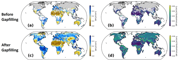
Wolfgang Preimesberger, Pietro Stradiotti, and Wouter Dorigo
Earth Syst. Sci. Data, 17, 4305–4329, https://doi.org/10.5194/essd-17-4305-2025, https://doi.org/10.5194/essd-17-4305-2025, 2025
Short summary
Short summary
We introduce the official ESA CCI Soil Moisture GAPFILLED climate data record. A univariate interpolation algorithm is applied to predict missing data points without relying on ancillary variables. The dataset includes gap-free uncertainty estimates for all predictions and was validated with independent in situ reference measurements. Our data record is recommended for applications which require global long-term gap-free satellite soil moisture data.
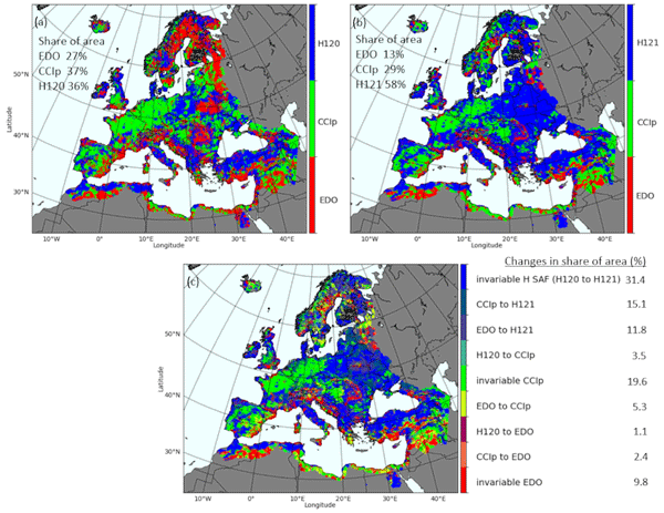
Jaime Gaona, Davide Bavera, Guido Fioravanti, Sebastian Hahn, Pietro Stradiotti, Paolo Filippucci, Stefania Camici, Luca Ciabatta, Hamidreza Mosaffa, Silvia Puca, Nicoletta Roberto, and Luca Brocca
Hydrol. Earth Syst. Sci., 29, 3865–3888, https://doi.org/10.5194/hess-29-3865-2025, https://doi.org/10.5194/hess-29-3865-2025, 2025
Short summary
Short summary
Soil moisture is crucial for the water cycle since it is at the front line of drought. Satellite, model and in situ data help identify soil moisture stress but are challenged by data uncertainties. This study evaluates trends and data coherence of common active/passive microwave sensors and model-based soil moisture data against in situ stations across Europe from 2007 to 2022. Data reliability is increasing, but combining data types improves soil moisture monitoring capabilities.
Bernhard Lehner, Mira Anand, Etienne Fluet-Chouinard, Florence Tan, Filipe Aires, George H. Allen, Philippe Bousquet, Josep G. Canadell, Nick Davidson, Meng Ding, C. Max Finlayson, Thomas Gumbricht, Lammert Hilarides, Gustaf Hugelius, Robert B. Jackson, Maartje C. Korver, Liangyun Liu, Peter B. McIntyre, Szabolcs Nagy, David Olefeldt, Tamlin M. Pavelsky, Jean-Francois Pekel, Benjamin Poulter, Catherine Prigent, Jida Wang, Thomas A. Worthington, Dai Yamazaki, Xiao Zhang, and Michele Thieme
Earth Syst. Sci. Data, 17, 2277–2329, https://doi.org/10.5194/essd-17-2277-2025, https://doi.org/10.5194/essd-17-2277-2025, 2025
Short summary
Short summary
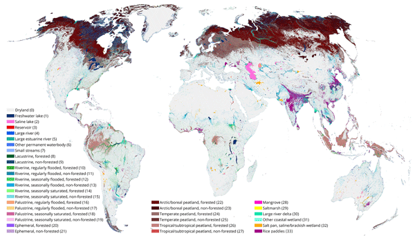
The Global Lakes and Wetlands Database (GLWD) version 2 distinguishes a total of 33 non-overlapping wetland classes, providing a static map of the world’s inland surface waters. It contains cell fractions of wetland extents per class at a grid cell resolution of ~500 m. The total combined extent of all classes including all inland and coastal waterbodies and wetlands of all inundation frequencies – that is, the maximum extent – covers 18.2 × 10⁶ km2, equivalent to 13.4 % of total global land area.
Wolfgang Knorr, Matthew Williams, Tea Thum, Thomas Kaminski, Michael Voßbeck, Marko Scholze, Tristan Quaife, T. Luke Smallman, Susan C. Steele-Dunne, Mariette Vreugdenhil, Tim Green, Sönke Zaehle, Mika Aurela, Alexandre Bouvet, Emanuel Bueechi, Wouter Dorigo, Tarek S. El-Madany, Mirco Migliavacca, Marika Honkanen, Yann H. Kerr, Anna Kontu, Juha Lemmetyinen, Hannakaisa Lindqvist, Arnaud Mialon, Tuuli Miinalainen, Gaétan Pique, Amanda Ojasalo, Shaun Quegan, Peter J. Rayner, Pablo Reyes-Muñoz, Nemesio Rodríguez-Fernández, Mike Schwank, Jochem Verrelst, Songyan Zhu, Dirk Schüttemeyer, and Matthias Drusch
Geosci. Model Dev., 18, 2137–2159, https://doi.org/10.5194/gmd-18-2137-2025, https://doi.org/10.5194/gmd-18-2137-2025, 2025
Short summary
Short summary
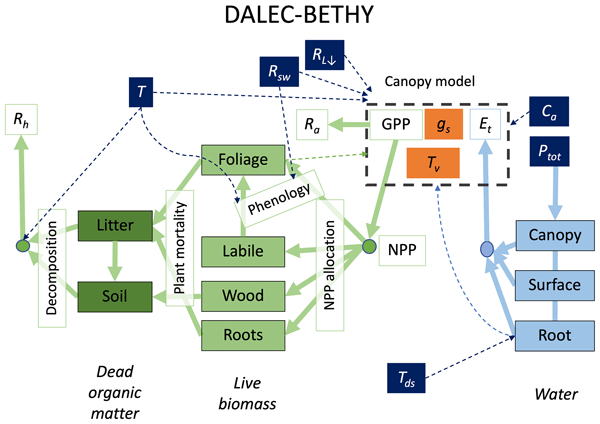
When it comes to climate change, the land surface is where the vast majority of impacts happen. The task of monitoring those impacts across the globe is formidable and must necessarily rely on satellites – at a significant cost: the measurements are only indirect and require comprehensive physical understanding. We have created a comprehensive modelling system that we offer to the research community to explore how satellite data can be better exploited to help us capture the changes that happen on our lands.
Alexis Jeantet, Jean-Pierre Vergnes, Simon Munier, and Florence Habets
EGUsphere, https://doi.org/10.5194/egusphere-2025-93, https://doi.org/10.5194/egusphere-2025-93, 2025
Short summary
Short summary
The AquiFR hydrogeological modelling plateform is forced by 36 climate projections in order to simulate future groundwater levels over France. The results show significant scatters between regional climate models and RCPs. Overall, a rise in groundwater levels, affecting most of the study area, is the dominant signal. Four storylines have been selected to to illustrate the impacts of worst-case scenarios and help decision-makers to adopt sustainable groundwater management policies.
Martin Hirschi, Pietro Stradiotti, Bas Crezee, Wouter Dorigo, and Sonia I. Seneviratne
Hydrol. Earth Syst. Sci., 29, 397–425, https://doi.org/10.5194/hess-29-397-2025, https://doi.org/10.5194/hess-29-397-2025, 2025
Short summary
Short summary
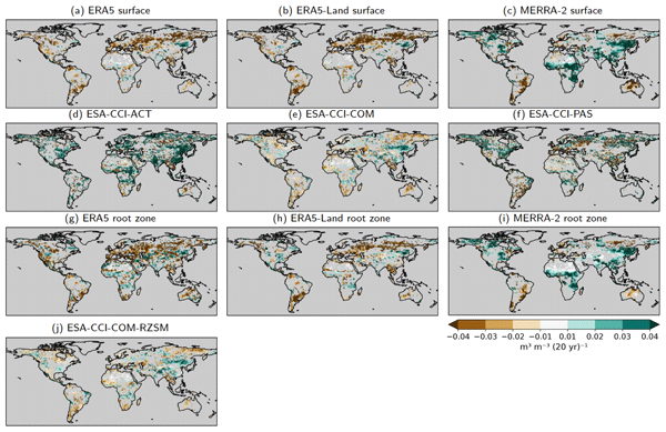
We investigate the potential of long-term satellite and reanalysis products for characterising soil drying by analysing their 2000–2022 soil moisture trends and their representation of agroecological drought events of this period. Soil moisture trends are globally diverse and partly contradictory between products. This also affects the products' drought-detection capacity. Based on the best-estimate products, consistent soil drying is observed over more than 40 % of the land area covered.
Laure Baratgin, Jan Polcher, Patrice Dumas, and Philippe Quirion
Hydrol. Earth Syst. Sci., 28, 5479–5509, https://doi.org/10.5194/hess-28-5479-2024, https://doi.org/10.5194/hess-28-5479-2024, 2024
Short summary
Short summary
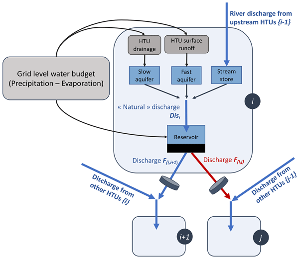
Hydrological modeling is valuable for estimating the potential impact of climate change on hydropower generation. This study presents a comprehensive approach to modeling the management of hydroelectric reservoirs in hydrological models. The total power grid demand for hydropower is distributed to the various power plants to compute their release. The method is tested on the French national power grid, and it is demonstrated that it successfully reproduces the observed behavior of reservoirs.
Malak Sadki, Gaëtan Noual, Simon Munier, Vanessa Pedinotti, Kaushlendra Verma, Clément Albergel, Sylvain Biancamaria, and Alice Andral
Hydrol. Earth Syst. Sci. Discuss., https://doi.org/10.5194/hess-2024-328, https://doi.org/10.5194/hess-2024-328, 2024
Revised manuscript accepted for HESS
Short summary
Short summary
This study explores how 20 years of remote-sensed discharge data from the ESA CCI improve large-scale hydrological models, CTRIP and MGB, through data assimilation. Using an EnKF framework across the Niger and Congo basins, it shows how assimilating denser temporal discharge data reduces biases and improves flow variability, enhancing accuracy. These findings underscore the role of long-term discharge data in refining models for climate assessments, water management, and forecasting.
Ling Zhang, Yanhua Xie, Xiufang Zhu, Qimin Ma, and Luca Brocca
Earth Syst. Sci. Data, 16, 5207–5226, https://doi.org/10.5194/essd-16-5207-2024, https://doi.org/10.5194/essd-16-5207-2024, 2024
Short summary
Short summary
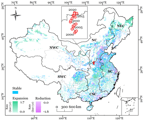
This study presented new annual maps of irrigated cropland in China from 2000 to 2020 (CIrrMap250). These maps were developed by integrating remote sensing data, irrigation statistics and surveys, and an irrigation suitability map. CIrrMap250 achieved high accuracy and outperformed currently available products. The new irrigation maps revealed a clear expansion of China’s irrigation area, with the majority (61%) occurring in the water-unsustainable regions facing severe to extreme water stress.

Ruxandra-Maria Zotta, Leander Moesinger, Robin van der Schalie, Mariette Vreugdenhil, Wolfgang Preimesberger, Thomas Frederikse, Richard de Jeu, and Wouter Dorigo
Earth Syst. Sci. Data, 16, 4573–4617, https://doi.org/10.5194/essd-16-4573-2024, https://doi.org/10.5194/essd-16-4573-2024, 2024
Short summary
Short summary
VODCA v2 is a dataset providing vegetation indicators for long-term ecosystem monitoring. VODCA v2 comprises two products: VODCA CXKu, spanning 34 years of observations (1987–2021), suitable for monitoring upper canopy dynamics, and VODCA L (2010–2021), for above-ground biomass monitoring. VODCA v2 has lower noise levels than the previous product version and provides valuable insights into plant water dynamics and biomass changes, even in areas where optical data are limited.
Peng Huang, Agnès Ducharne, Lucia Rinchiuso, Jan Polcher, Laure Baratgin, Vladislav Bastrikov, and Eric Sauquet
Hydrol. Earth Syst. Sci., 28, 4455–4476, https://doi.org/10.5194/hess-28-4455-2024, https://doi.org/10.5194/hess-28-4455-2024, 2024
Short summary
Short summary
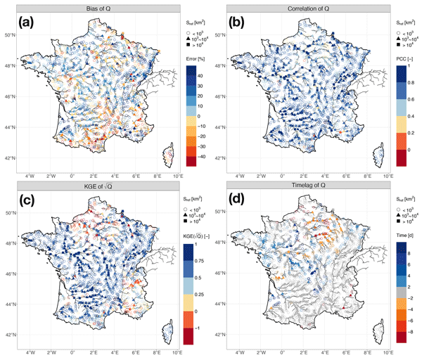
We conducted a high-resolution hydrological simulation from 1959 to 2020 across France. We used a simple trial-and-error calibration to reduce the biases of the simulated water budget compared to observations. The selected simulation satisfactorily reproduces water fluxes, including their spatial contrasts and temporal trends. This work offers a reliable historical overview of water resources and a robust configuration for climate change impact analysis at the nationwide scale of France.
Jacopo Dari, Paolo Filippucci, and Luca Brocca
Hydrol. Earth Syst. Sci., 28, 2651–2659, https://doi.org/10.5194/hess-28-2651-2024, https://doi.org/10.5194/hess-28-2651-2024, 2024
Short summary
Short summary
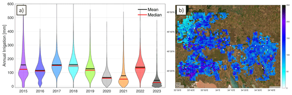
We have developed the first operational system (10 d latency) for estimating irrigation water use from accessible satellite and reanalysis data. As a proof of concept, the method has been implemented over an irrigated area fed by the Kakhovka Reservoir, in Ukraine, which collapsed on June 6, 2023. Estimates for the period 2015–2023 reveal that, as expected, the irrigation season of 2023 was characterized by the lowest amounts of irrigation.
Søren Julsgaard Kragh, Jacopo Dari, Sara Modanesi, Christian Massari, Luca Brocca, Rasmus Fensholt, Simon Stisen, and Julian Koch
Hydrol. Earth Syst. Sci., 28, 441–457, https://doi.org/10.5194/hess-28-441-2024, https://doi.org/10.5194/hess-28-441-2024, 2024
Short summary
Short summary
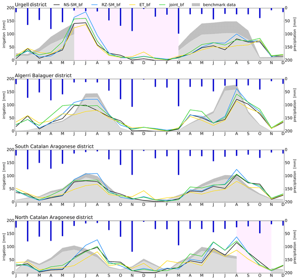
This study provides a comparison of methodologies to quantify irrigation to enhance regional irrigation estimates. To evaluate the methodologies, we compared various approaches to quantify irrigation using soil moisture, evapotranspiration, or both within a novel baseline framework, together with irrigation estimates from other studies. We show that the synergy from using two equally important components in a joint approach within a baseline framework yields better irrigation estimates.
Samuel Scherrer, Gabriëlle De Lannoy, Zdenko Heyvaert, Michel Bechtold, Clement Albergel, Tarek S. El-Madany, and Wouter Dorigo
Hydrol. Earth Syst. Sci., 27, 4087–4114, https://doi.org/10.5194/hess-27-4087-2023, https://doi.org/10.5194/hess-27-4087-2023, 2023
Short summary
Short summary
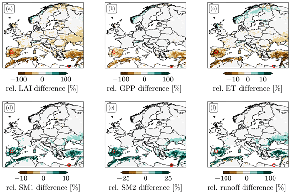
We explored different options for data assimilation (DA) of the remotely sensed leaf area index (LAI). We found strong biases between LAI predicted by Noah-MP and observations. LAI DA that does not take these biases into account can induce unphysical patterns in the resulting LAI and flux estimates and leads to large changes in the climatology of root zone soil moisture. We tested two bias-correction approaches and explored alternative solutions to treating bias in LAI DA.
Julia Pfeffer, Anny Cazenave, Alejandro Blazquez, Bertrand Decharme, Simon Munier, and Anne Barnoud
Hydrol. Earth Syst. Sci., 27, 3743–3768, https://doi.org/10.5194/hess-27-3743-2023, https://doi.org/10.5194/hess-27-3743-2023, 2023
Short summary
Short summary
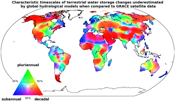
The GRACE (Gravity Recovery And Climate Experiment) satellite mission enabled the quantification of water mass redistributions from 2002 to 2017. The analysis of GRACE satellite data shows here that slow changes in terrestrial water storage occurring over a few years to a decade are severely underestimated by global hydrological models. Several sources of errors may explain such biases, likely including the inaccurate representation of groundwater storage changes.
Anthony Schrapffer, Jan Polcher, Anna Sörensson, and Lluís Fita
Geosci. Model Dev., 16, 5755–5782, https://doi.org/10.5194/gmd-16-5755-2023, https://doi.org/10.5194/gmd-16-5755-2023, 2023
Short summary
Short summary
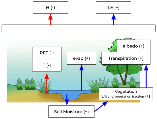
The present paper introduces a floodplain scheme for a high-resolution land surface model river routing. It was developed and evaluated over one of the world’s largest floodplains: the Pantanal in South America. This shows the impact of tropical floodplains on land surface conditions (soil moisture, temperature) and on land–atmosphere fluxes and highlights the potential impact of floodplains on land–atmosphere interactions and the importance of integrating this module in coupled simulations.
Laurent Strohmenger, Eric Sauquet, Claire Bernard, Jérémie Bonneau, Flora Branger, Amélie Bresson, Pierre Brigode, Rémy Buzier, Olivier Delaigue, Alexandre Devers, Guillaume Evin, Maïté Fournier, Shu-Chen Hsu, Sandra Lanini, Alban de Lavenne, Thibault Lemaitre-Basset, Claire Magand, Guilherme Mendoza Guimarães, Max Mentha, Simon Munier, Charles Perrin, Tristan Podechard, Léo Rouchy, Malak Sadki, Myriam Soutif-Bellenger, François Tilmant, Yves Tramblay, Anne-Lise Véron, Jean-Philippe Vidal, and Guillaume Thirel
Hydrol. Earth Syst. Sci., 27, 3375–3391, https://doi.org/10.5194/hess-27-3375-2023, https://doi.org/10.5194/hess-27-3375-2023, 2023
Short summary
Short summary
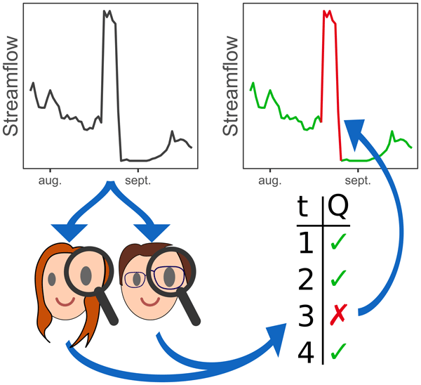
We present the results of a large visual inspection campaign of 674 streamflow time series in France. The objective was to detect non-natural records resulting from instrument failure or anthropogenic influences, such as hydroelectric power generation or reservoir management. We conclude that the identification of flaws in flow time series is highly dependent on the objectives and skills of individual evaluators, and we raise the need for better practices for data cleaning.
Adam Pasik, Alexander Gruber, Wolfgang Preimesberger, Domenico De Santis, and Wouter Dorigo
Geosci. Model Dev., 16, 4957–4976, https://doi.org/10.5194/gmd-16-4957-2023, https://doi.org/10.5194/gmd-16-4957-2023, 2023
Short summary
Short summary
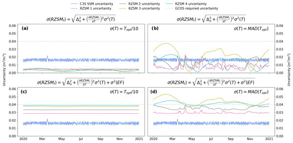
We apply the exponential filter (EF) method to satellite soil moisture retrievals to estimate the water content in the unobserved root zone globally from 2002–2020. Quality assessment against an independent dataset shows satisfactory results. Error characterization is carried out using the standard uncertainty propagation law and empirically estimated values of EF model structural uncertainty and parameter uncertainty. This is followed by analysis of temporal uncertainty variations.
Jan Polcher, Anthony Schrapffer, Eliott Dupont, Lucia Rinchiuso, Xudong Zhou, Olivier Boucher, Emmanuel Mouche, Catherine Ottlé, and Jérôme Servonnat
Geosci. Model Dev., 16, 2583–2606, https://doi.org/10.5194/gmd-16-2583-2023, https://doi.org/10.5194/gmd-16-2583-2023, 2023
Short summary
Short summary
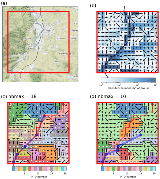
The proposed graphs of hydrological sub-grid elements for atmospheric models allow us to integrate the topographical elements needed in land surface models for a realistic representation of horizontal water and energy transport. The study demonstrates the numerical properties of the automatically built graphs and the simulated water flows.
Jacopo Dari, Luca Brocca, Sara Modanesi, Christian Massari, Angelica Tarpanelli, Silvia Barbetta, Raphael Quast, Mariette Vreugdenhil, Vahid Freeman, Anaïs Barella-Ortiz, Pere Quintana-Seguí, David Bretreger, and Espen Volden
Earth Syst. Sci. Data, 15, 1555–1575, https://doi.org/10.5194/essd-15-1555-2023, https://doi.org/10.5194/essd-15-1555-2023, 2023
Short summary
Short summary
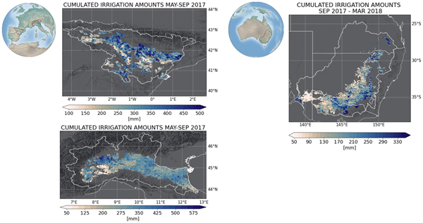
Irrigation is the main source of global freshwater consumption. Despite this, a detailed knowledge of irrigation dynamics (i.e., timing, extent of irrigated areas, and amounts of water used) are generally lacking worldwide. Satellites represent a useful tool to fill this knowledge gap and monitor irrigation water from space. In this study, three regional-scale and high-resolution (1 and 6 km) products of irrigation amounts estimated by inverting the satellite soil moisture signals are presented.
Remi Madelon, Nemesio J. Rodríguez-Fernández, Hassan Bazzi, Nicolas Baghdadi, Clement Albergel, Wouter Dorigo, and Mehrez Zribi
Hydrol. Earth Syst. Sci., 27, 1221–1242, https://doi.org/10.5194/hess-27-1221-2023, https://doi.org/10.5194/hess-27-1221-2023, 2023
Short summary
Short summary
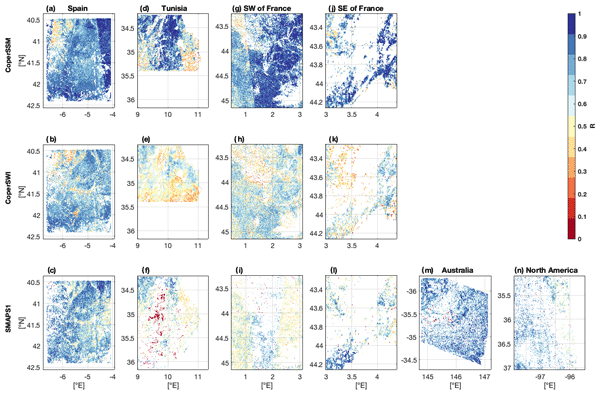
We present an approach to estimate soil moisture (SM) at 1 km resolution using Sentinel-1 and Sentinel-3 satellites. The estimates were compared to other high-resolution (HR) datasets over Europe, northern Africa, Australia, and North America, showing good agreement. However, the discrepancies between the different HR datasets and their lower performances compared with in situ measurements and coarse-resolution datasets show the remaining challenges for large-scale HR SM mapping.
Luisa Schmidt, Matthias Forkel, Ruxandra-Maria Zotta, Samuel Scherrer, Wouter A. Dorigo, Alexander Kuhn-Régnier, Robin van der Schalie, and Marta Yebra
Biogeosciences, 20, 1027–1046, https://doi.org/10.5194/bg-20-1027-2023, https://doi.org/10.5194/bg-20-1027-2023, 2023
Short summary
Short summary
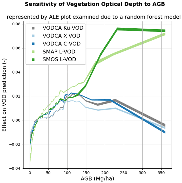
Vegetation attenuates natural microwave emissions from the land surface. The strength of this attenuation is quantified as the vegetation optical depth (VOD) parameter and is influenced by the vegetation mass, structure, water content, and observation wavelength. Here we model the VOD signal as a multi-variate function of several descriptive vegetation variables. The results help in understanding the effects of ecosystem properties on VOD.
Taylor Smith, Ruxandra-Maria Zotta, Chris A. Boulton, Timothy M. Lenton, Wouter Dorigo, and Niklas Boers
Earth Syst. Dynam., 14, 173–183, https://doi.org/10.5194/esd-14-173-2023, https://doi.org/10.5194/esd-14-173-2023, 2023
Short summary
Short summary
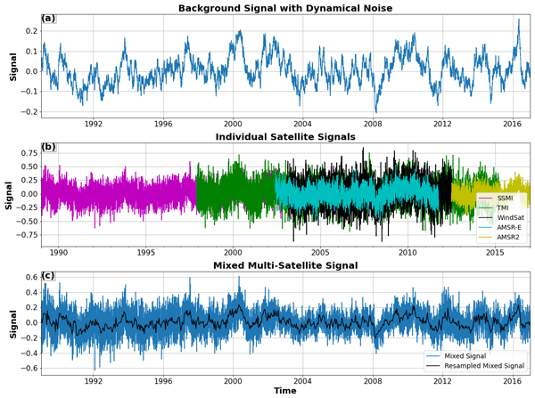
Multi-instrument records with varying signal-to-noise ratios are becoming increasingly common as legacy sensors are upgraded, and data sets are modernized. Induced changes in higher-order statistics such as the autocorrelation and variance are not always well captured by cross-calibration schemes. Here we investigate using synthetic examples how strong resulting biases can be and how they can be avoided in order to make reliable statements about changes in the resilience of a system.

Malak Sadki, Simon Munier, Aaron Boone, and Sophie Ricci
Geosci. Model Dev., 16, 427–448, https://doi.org/10.5194/gmd-16-427-2023, https://doi.org/10.5194/gmd-16-427-2023, 2023
Short summary
Short summary
Predicting water resource evolution is a key challenge for the coming century.
Anthropogenic impacts on water resources, and particularly the effects of dams and reservoirs on river flows, are still poorly known and generally neglected in global hydrological studies. A parameterized reservoir model is reproduced to compute monthly releases in Spanish anthropized river basins. For global application, an exhaustive sensitivity analysis of the model parameters is performed on flows and volumes.
Kunlong He, Wei Zhao, Luca Brocca, and Pere Quintana-Seguí
Hydrol. Earth Syst. Sci., 27, 169–190, https://doi.org/10.5194/hess-27-169-2023, https://doi.org/10.5194/hess-27-169-2023, 2023
Short summary
Short summary
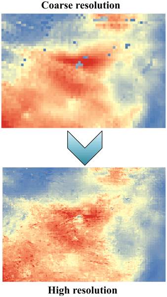
In this study, we developed a soil moisture-based precipitation downscaling (SMPD) method for spatially downscaling the GPM daily precipitation product by exploiting the connection between surface soil moisture and precipitation according to the soil water balance equation. Based on this physical method, the spatial resolution of the daily precipitation product was downscaled to 1 km and the SMPD method shows good potential for the development of the high-resolution precipitation product.
Matthias Forkel, Luisa Schmidt, Ruxandra-Maria Zotta, Wouter Dorigo, and Marta Yebra
Hydrol. Earth Syst. Sci., 27, 39–68, https://doi.org/10.5194/hess-27-39-2023, https://doi.org/10.5194/hess-27-39-2023, 2023
Short summary
Short summary
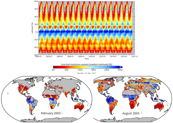
The live fuel moisture content (LFMC) of vegetation canopies is a driver of wildfires. We investigate the relation between LFMC and passive microwave satellite observations of vegetation optical depth (VOD) and develop a method to estimate LFMC from VOD globally. Our global VOD-based estimates of LFMC can be used to investigate drought effects on vegetation and fire risks.
Arsène Druel, Simon Munier, Anthony Mucia, Clément Albergel, and Jean-Christophe Calvet
Geosci. Model Dev., 15, 8453–8471, https://doi.org/10.5194/gmd-15-8453-2022, https://doi.org/10.5194/gmd-15-8453-2022, 2022
Short summary
Short summary
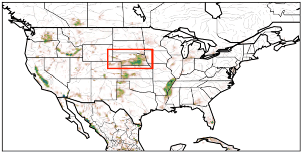
Crop phenology and irrigation is implemented into a land surface model able to work at a global scale. A case study is presented over Nebraska (USA). Simulations with and without the new scheme are compared to different satellite-based observations. The model is able to produce a realistic yearly irrigation water amount. The irrigation scheme improves the simulated leaf area index, gross primary productivity, evapotransipiration, and land surface temperature.
Leander Moesinger, Ruxandra-Maria Zotta, Robin van der Schalie, Tracy Scanlon, Richard de Jeu, and Wouter Dorigo
Biogeosciences, 19, 5107–5123, https://doi.org/10.5194/bg-19-5107-2022, https://doi.org/10.5194/bg-19-5107-2022, 2022
Short summary
Short summary
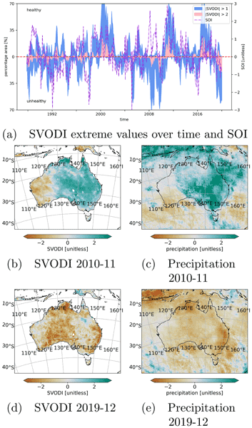
The standardized vegetation optical depth index (SVODI) can be used to monitor the vegetation condition, such as whether the vegetation is unusually dry or wet. SVODI has global coverage, spans the past 3 decades and is derived from multiple spaceborne passive microwave sensors of that period. SVODI is based on a new probabilistic merging method that allows the merging of normally distributed data even if the data are not gap-free.
Sara Modanesi, Christian Massari, Michel Bechtold, Hans Lievens, Angelica Tarpanelli, Luca Brocca, Luca Zappa, and Gabriëlle J. M. De Lannoy
Hydrol. Earth Syst. Sci., 26, 4685–4706, https://doi.org/10.5194/hess-26-4685-2022, https://doi.org/10.5194/hess-26-4685-2022, 2022
Short summary
Short summary
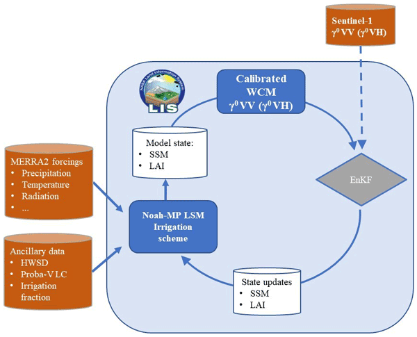
Given the crucial impact of irrigation practices on the water cycle, this study aims at estimating irrigation through the development of an innovative data assimilation system able to ingest high-resolution Sentinel-1 radar observations into the Noah-MP land surface model. The developed methodology has important implications for global water resource management and the comprehension of human impacts on the water cycle and identifies main challenges and outlooks for future research.

Stefania Camici, Gabriele Giuliani, Luca Brocca, Christian Massari, Angelica Tarpanelli, Hassan Hashemi Farahani, Nico Sneeuw, Marco Restano, and Jérôme Benveniste
Geosci. Model Dev., 15, 6935–6956, https://doi.org/10.5194/gmd-15-6935-2022, https://doi.org/10.5194/gmd-15-6935-2022, 2022
Short summary
Short summary
This paper presents an innovative approach, STREAM (SaTellite-based Runoff Evaluation And Mapping), to derive daily river discharge and runoff estimates from satellite observations of soil moisture, precipitation, and terrestrial total water storage anomalies. Potentially useful for multiple operational and scientific applications, the added value of the STREAM approach is the ability to increase knowledge on the natural processes, human activities, and their interactions on the land.
Lorenzo Alfieri, Francesco Avanzi, Fabio Delogu, Simone Gabellani, Giulia Bruno, Lorenzo Campo, Andrea Libertino, Christian Massari, Angelica Tarpanelli, Dominik Rains, Diego G. Miralles, Raphael Quast, Mariette Vreugdenhil, Huan Wu, and Luca Brocca
Hydrol. Earth Syst. Sci., 26, 3921–3939, https://doi.org/10.5194/hess-26-3921-2022, https://doi.org/10.5194/hess-26-3921-2022, 2022
Short summary
Short summary
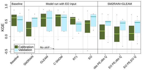
This work shows advances in high-resolution satellite data for hydrology. We performed hydrological simulations for the Po River basin using various satellite products, including precipitation, evaporation, soil moisture, and snow depth. Evaporation and snow depth improved a simulation based on high-quality ground observations. Interestingly, a model calibration relying on satellite data skillfully reproduces observed discharges, paving the way to satellite-driven hydrological applications.
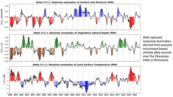
Robin van der Schalie, Mendy van der Vliet, Clément Albergel, Wouter Dorigo, Piotr Wolski, and Richard de Jeu
Hydrol. Earth Syst. Sci., 26, 3611–3627, https://doi.org/10.5194/hess-26-3611-2022, https://doi.org/10.5194/hess-26-3611-2022, 2022
Short summary
Short summary
Climate data records of surface soil moisture, vegetation optical depth, and land surface temperature can be derived from passive microwave observations. The ability of these datasets to properly detect anomalies and extremes is very valuable in climate research and can especially help to improve our insight in complex regions where the current climate reanalysis datasets reach their limitations. Here, we present a case study over the Okavango Delta, where we focus on inter-annual variability.
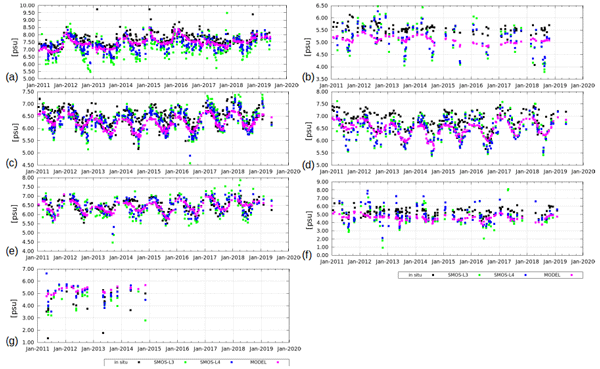
Verónica González-Gambau, Estrella Olmedo, Antonio Turiel, Cristina González-Haro, Aina García-Espriu, Justino Martínez, Pekka Alenius, Laura Tuomi, Rafael Catany, Manuel Arias, Carolina Gabarró, Nina Hoareau, Marta Umbert, Roberto Sabia, and Diego Fernández
Earth Syst. Sci. Data, 14, 2343–2368, https://doi.org/10.5194/essd-14-2343-2022, https://doi.org/10.5194/essd-14-2343-2022, 2022
Short summary
Short summary
We present the first Soil Moisture and Ocean Salinity Sea Surface Salinity (SSS) dedicated products over the Baltic Sea (ESA Baltic+ Salinity Dynamics). The Baltic+ L3 product covers 9 days in a 0.25° grid. The Baltic+ L4 is derived by merging L3 SSS with sea surface temperature information, giving a daily product in a 0.05° grid. The accuracy of L3 is 0.7–0.8 and 0.4 psu for the L4. Baltic+ products have shown to be useful, covering spatiotemporal data gaps and for validating numerical models.

Simon Munier and Bertrand Decharme
Earth Syst. Sci. Data, 14, 2239–2258, https://doi.org/10.5194/essd-14-2239-2022, https://doi.org/10.5194/essd-14-2239-2022, 2022
Short summary
Short summary
This paper presents a new global-scale river network at 1/12°, generated automatically and assessed over the 69 largest basins of the world. A set of hydro-geomorphological parameters are derived at the same spatial resolution, including a description of river stretches (length, slope, width, roughness, bankfull depth), floodplains (roughness, sub-grid topography) and aquifers (transmissivity, porosity, sub-grid topography). The dataset may be useful for hydrology modelling or climate studies.
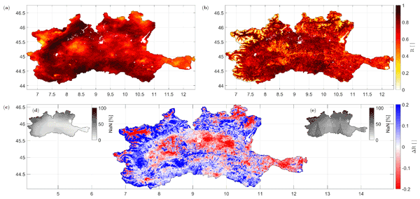
Paolo Filippucci, Luca Brocca, Raphael Quast, Luca Ciabatta, Carla Saltalippi, Wolfgang Wagner, and Angelica Tarpanelli
Hydrol. Earth Syst. Sci., 26, 2481–2497, https://doi.org/10.5194/hess-26-2481-2022, https://doi.org/10.5194/hess-26-2481-2022, 2022
Short summary
Short summary
A high-resolution (1 km) rainfall product with 10–30 d temporal resolution was obtained starting from SM data from Sentinel-1. Good performances are achieved using observed data (gauge and radar) over the Po River Valley, Italy, as a benchmark. The comparison with a product characterized by lower spatial resolution (25 km) highlights areas where the high spatial resolution of Sentinel-1 has great benefits. Possible applications include water management, agriculture and index-based insurances.
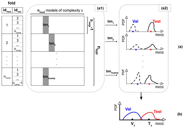
Thi Lan Anh Dinh and Filipe Aires
Geosci. Model Dev., 15, 3519–3535, https://doi.org/10.5194/gmd-15-3519-2022, https://doi.org/10.5194/gmd-15-3519-2022, 2022
Short summary
Short summary
We proposed the leave-two-out method (i.e. one particular implementation of the nested cross-validation) to determine the optimal statistical crop model (using the validation dataset) and estimate its true generalization ability (using the testing dataset). This approach is applied to two examples (robusta coffee in Cu M'gar and grain maize in France). The results suggested that the simple models are more suitable in crop modelling where a limited number of samples is available.
Marie Bouillon, Sarah Safieddine, Simon Whitburn, Lieven Clarisse, Filipe Aires, Victor Pellet, Olivier Lezeaux, Noëlle A. Scott, Marie Doutriaux-Boucher, and Cathy Clerbaux
Atmos. Meas. Tech., 15, 1779–1793, https://doi.org/10.5194/amt-15-1779-2022, https://doi.org/10.5194/amt-15-1779-2022, 2022
Short summary
Short summary
The IASI instruments have been observing Earth since 2007. We use a neural network to retrieve atmospheric temperatures. This new temperature data record is validated against other datasets and shows good agreement. We use this new dataset to compute trends over the 2008–2020 period. We found a warming of the troposphere, more important at the poles. In the stratosphere, we found that temperatures decrease everywhere except at the South Pole. The cooling is more pronounced at the South pole.
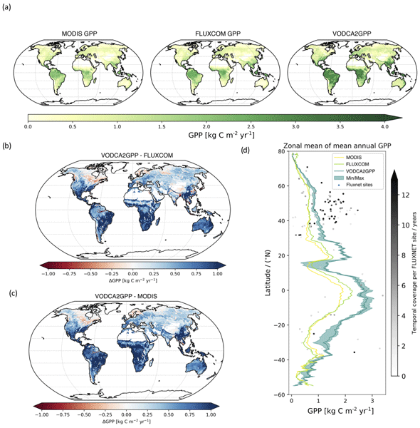
Benjamin Wild, Irene Teubner, Leander Moesinger, Ruxandra-Maria Zotta, Matthias Forkel, Robin van der Schalie, Stephen Sitch, and Wouter Dorigo
Earth Syst. Sci. Data, 14, 1063–1085, https://doi.org/10.5194/essd-14-1063-2022, https://doi.org/10.5194/essd-14-1063-2022, 2022
Short summary
Short summary
Gross primary production (GPP) describes the conversion of CO2 to carbohydrates and can be seen as a filter for our atmosphere of the primary greenhouse gas CO2. We developed VODCA2GPP, a GPP dataset that is based on vegetation optical depth from microwave remote sensing and temperature. Thus, it is mostly independent from existing GPP datasets and also available in regions with frequent cloud coverage. Analysis showed that VODCA2GPP is able to complement existing state-of-the-art GPP datasets.

Stefan Schlaffer, Marco Chini, Wouter Dorigo, and Simon Plank
Hydrol. Earth Syst. Sci., 26, 841–860, https://doi.org/10.5194/hess-26-841-2022, https://doi.org/10.5194/hess-26-841-2022, 2022
Short summary
Short summary
Prairie wetlands are important for biodiversity and water availability. Knowledge about their variability and spatial distribution is of great use in conservation and water resources management. In this study, we propose a novel approach for the classification of small water bodies from satellite radar images and apply it to our study area over 6 years. The retrieved dynamics show the different responses of small and large wetlands to dry and wet periods.
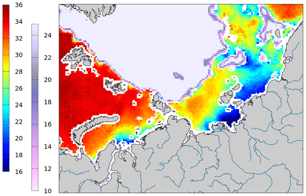
Justino Martínez, Carolina Gabarró, Antonio Turiel, Verónica González-Gambau, Marta Umbert, Nina Hoareau, Cristina González-Haro, Estrella Olmedo, Manuel Arias, Rafael Catany, Laurent Bertino, Roshin P. Raj, Jiping Xie, Roberto Sabia, and Diego Fernández
Earth Syst. Sci. Data, 14, 307–323, https://doi.org/10.5194/essd-14-307-2022, https://doi.org/10.5194/essd-14-307-2022, 2022
Short summary
Short summary
Measuring salinity from space is challenging since the sensitivity of the brightness temperature to sea surface salinity is low, but the retrieval of SSS in cold waters is even more challenging. In 2019, the ESA launched a specific initiative called Arctic+Salinity to produce an enhanced Arctic SSS product with better quality and resolution than the available products. This paper presents the methodologies used to produce the new enhanced Arctic SMOS SSS product.
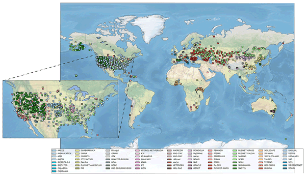
Wouter Dorigo, Irene Himmelbauer, Daniel Aberer, Lukas Schremmer, Ivana Petrakovic, Luca Zappa, Wolfgang Preimesberger, Angelika Xaver, Frank Annor, Jonas Ardö, Dennis Baldocchi, Marco Bitelli, Günter Blöschl, Heye Bogena, Luca Brocca, Jean-Christophe Calvet, J. Julio Camarero, Giorgio Capello, Minha Choi, Michael C. Cosh, Nick van de Giesen, Istvan Hajdu, Jaakko Ikonen, Karsten H. Jensen, Kasturi Devi Kanniah, Ileen de Kat, Gottfried Kirchengast, Pankaj Kumar Rai, Jenni Kyrouac, Kristine Larson, Suxia Liu, Alexander Loew, Mahta Moghaddam, José Martínez Fernández, Cristian Mattar Bader, Renato Morbidelli, Jan P. Musial, Elise Osenga, Michael A. Palecki, Thierry Pellarin, George P. Petropoulos, Isabella Pfeil, Jarrett Powers, Alan Robock, Christoph Rüdiger, Udo Rummel, Michael Strobel, Zhongbo Su, Ryan Sullivan, Torbern Tagesson, Andrej Varlagin, Mariette Vreugdenhil, Jeffrey Walker, Jun Wen, Fred Wenger, Jean Pierre Wigneron, Mel Woods, Kun Yang, Yijian Zeng, Xiang Zhang, Marek Zreda, Stephan Dietrich, Alexander Gruber, Peter van Oevelen, Wolfgang Wagner, Klaus Scipal, Matthias Drusch, and Roberto Sabia
Hydrol. Earth Syst. Sci., 25, 5749–5804, https://doi.org/10.5194/hess-25-5749-2021, https://doi.org/10.5194/hess-25-5749-2021, 2021
Short summary
Short summary
The International Soil Moisture Network (ISMN) is a community-based open-access data portal for soil water measurements taken at the ground and is accessible at https://ismn.earth. Over 1000 scientific publications and thousands of users have made use of the ISMN. The scope of this paper is to inform readers about the data and functionality of the ISMN and to provide a review of the scientific progress facilitated through the ISMN with the scope to shape future research and operations.
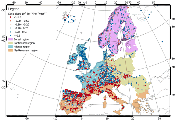
Daniele Masseroni, Stefania Camici, Alessio Cislaghi, Giorgio Vacchiano, Christian Massari, and Luca Brocca
Hydrol. Earth Syst. Sci., 25, 5589–5601, https://doi.org/10.5194/hess-25-5589-2021, https://doi.org/10.5194/hess-25-5589-2021, 2021
Short summary
Short summary
We evaluate 63 years of changes in annual streamflow volume across Europe, using a data set of more than 3000 stations, with a special focus on the Mediterranean basin. The results show decreasing (increasing) volumes in the southern (northern) regions. These trends are strongly consistent with the changes in temperature and precipitation.
Cited articles
Adler, R. F., Huffman, G. J., Chang, A., Ferraro, R., Xie, P.-P., Janowiak, J.,
Rudolf, B., Schneider, U., Curtis, S., Bolvin, D., Gruber, A., Susskind, J.,
Arkin, P., and Nelkin, E.: The Version-2 Global Precipitation Climatology
Project (GPCP) Monthly Precipitation Analysis (1979–Present), J. Hydrometeorol.,
4, 1147–1167, https://doi.org/10.1175/1525-7541(2003)004<1147:TVGPCP>2.0.CO;2, 2003. a, b
Allen, R. G., Pereira, L. S., Raes, D., and Smith, M.: Crop evapotranspiration:
Guidelines for computing crop water requirements, FAO irrigation and drainage
paper 56, FAO, Rome, 300, 6541, 1998. a
Ashouri, H., Hsu, K.-L., Sorooshian, S., Braithwaite, D. K., Knapp, K. R.,
Cecil, L. D., Nelson, B. R., Prat, O. P., Ashouri, H., Hsu, K.-L., Sorooshian,
S., Braithwaite, D. K., Knapp, K. R., Cecil, L. D., Nelson, B. R., and Prat,
O. P.: PERSIANN-CDR: Daily Precipitation Climate Data Record from Multisatellite
Observations for Hydrological and Climate Studies, B. Am. Meteorol. Soc., 96,
69–83, https://doi.org/10.1175/BAMS-D-13-00068.1, 2015. a, b
Bahurel, P., Ocean, M., Bell, M.-O., and Le Traon, P.: Ocean Monitoring and
Forecasting in the European MyOcean GMES Marine Initiative, available at:
http://marine.copernicus.eu/wp-content/uploads/2016/06/r652_9_pierre_bahurel_talk.pdf
(last access: 24 January 2019), 2012. a
Biancale, R., Lemoine, J.-M., Bruinsma, S., and Bourgogne, S.: 10-day time
series of the geoid from GRACE and LAGEOS data Evaluation of solutions
Processing standards Mean field and 10-day solutions Noise estimation over
global oceans, CNES, Toulouse, France, available at: ftp://ftp.csr.utexas.edu/pub/grace/Proceedings/GSTM_2009_Extras/Posters/Biancale_Poster.pdf
(last access: 24 January 2019), 2005. a, b
Brown, P. J. and Kummerow, C. D.: An Assessment of Atmospheric Water Budget
Components over Tropical Oceans, J. Climate, 27, 2054–2071, https://doi.org/10.1175/JCLI-D-13-00385.1, 2013. a
Chen, X., Su, Z., Ma, Y., Yang, K., Wen, J., and Zhang, Y.: An improvement of
roughness height parameterization of the Surface Energy Balance System (SEBS)
over the Tibetan plateau, J. Appl. Meteorol. Clim., 52, 607–622, https://doi.org/10.1175/JAMC-D-12-056.1, 2013. a
Curry, J. A., Bentamy, A., Bourassa, M. A., Bourras, D., Bradley, E. F., Brunke,
M., Castro, S., Chou, S. H., Clayson, C. A., Emery, W. J., Eymard, L., Fairall,
C. W., Kubota, M., Lin, B., Perrie, W., Reeder, R. A., Renfrew, I. A., Rossow,
W. B., Schulz, J., Smith, S. R., Webster, P. J., Wick, G. A., Zeng, X., Curry,
J. A., Bentamy, A., Bourassa, M. A., Bourras, D., Bradley, E. F., Brunke, M.,
Castro, S., Chou, S. H., Clayson, C. A., Emery, W. J., Eymard, L., Fairall, C.
W., Kubota, M., Lin, B., Perrie, W., Reeder, R. A., Renfrew, I. A., Rossow, W.
B., Schulz, J., Smith, S. R., Webster, P. J., Wick, G. A., and Zeng, X.: SEAFLUX,
B. Am. Meteorol. Soc., 85, 409–424, https://doi.org/10.1175/BAMS-85-3-409, 2004. a, b
Dahle, C., Flechtner, F., Gruber, C., König, D., König, R., Michalak,
G., and Neumayer, K.-H.: GFZ GRACE Level-2 Processing Standards Document for
Level-2 Product Release 0005, Scientific Technical Report – Data; 12/02,
Deutsches GeoForschungsZentrum GFZ, Potsdam, p. 20, https://doi.org/10.2312/GFZ.b103-12020, 2013. a, b
Dee, D. P., Uppala, S. M., Simmons, A. J., Berrisford, P., Poli, P., Kobayashi,
S., Andrae, U., Balmaseda, M. A., Balsamo, G., Bauer, P., Bechtold, P., Beljaars,
A. C. M., van de Berg, L., Bidlot, J., Bormann, N., Delsol, C., Dragani, R.,
Fuentes, M., Geer, A. J., Haimberger, L., Healy, S. B., Hersbach, H., Hólm,
E. V., Isaksen, L., Kållberg, P., Köhler, M., Matricardi, M., McNally,
A. P., Monge-Sanz, B. M., Morcrette, J.-J., Park, B.-K., Peubey, C., de Rosnay,
P., Tavolato, C., Thépaut, J.-N., and Vitart, F.: The ERA-Interim reanalysis:
configuration and performance of the data assimilation system, Q. J. Roy.
Meteorol. Soc., 137, 553–597, https://doi.org/10.1002/qj.828, 2011. a, b, c, d, e, f, g
De Geeter, J., Van Brussel, H., De Schutter, J., and Decreton, M.: A smoothly
constrained Kalman filter, IEEE Trans. Pattern Anal. Mach. Intell., 19,
1171–1177, https://doi.org/10.1109/34.625129, 1997. a
Ducharne, A., Golaz, C., Leblois, E., Laval, K., Polcher, J., Ledoux, E., and
de Marsily, G.: Development of a high resolution runoff routing model,
calibration and application to assess runoff from the LMD GCM, J. Hydrol.,
280, 207–228, https://doi.org/10.1016/S0022-1694(03)00230-0, 2003. a
Eicker, A., Forootan, E., Springer, A., and Longuevergne, L.: Does GRACE see
the terrestrial water cycle `intensifying'?, J. Geophys. Res., 121, 733–745, 2016. a
Falge, E., Aubinet, M., Bakwin, P., Baldocchi, D., Berbigier, P., Bernhofer,
C., Black, T., Ceulemans, R., Davis, K., Dolman, A., Goldstein, A., Goulden,
M., Granier, A., Hollinger, D., Jarvis, P., Jensen, N., Pilegaard, K., Katul,
G., Kyaw Tha Paw, P., Law, B., Lindroth, A., Loustau, D., Mahli, Y., Monson,
R., Moncrieff, P., Moors, E., Munger, J., Meyers, T., Oechel, W., Schulze,
E.-D., Thorgeirsson, H., Tenhunen, J., Valentini, R., Verma, S., Vesala, T.,
and Wofsy, S.: FLUXNET Research Network Site Characteristics, Investigators,
and Bibliography, 2016, https://doi.org/10.3334/ORNLDAAC/1530, 2017. a, b, c
Fenoglio-Marc, L., Kusche, J., and Becker, M.: Mass variation in the Mediterranean
Sea from GRACE and its validation by altimetry, steric and hydrologic fields,
Geophys. Res. Lett., 33, 1–5, https://doi.org/10.1029/2006GL026851, 2006. a
Good, S. A., Martin, M. J., and Rayner, N. A.: EN4: Quality controlled ocean
temperature and salinity profiles and monthly objective analyses with
uncertainty estimates, J. Geophys. Res.-Oceans, 118, 6704–6716,
https://doi.org/10.1002/2013JC009067, 2013. a
Hamon, M., Beuvier, J., Somot, S., Lellouche, J.-M., Greiner, E., Jordà,
G., Bouin, M.-N., Arsouze, T., Béranger, K., Sevault, F., Dubois, C.,
Drevillon, M., and Drillet, Y.: Design and validation of MEDRYS, a Mediterranean
Sea reanalysis over the period 1992–2013, Ocean Sci., 12, 577–599,
https://doi.org/10.5194/os-12-577-2016, 2016. a
Harzallah, A., Jordà, G., Dubois, C., Sannino, G., Carillo, A., Li, L.,
Arsouze, T., Cavicchia, L., Beuvier, J., and Akhtar, N.: Long term evolution
of heat budget in the Mediterranean Sea from Med-CORDEX forced and coupled
simulations, Clim. Dynam., 51, 1145, https://doi.org/10.1007/s00382-016-3363-5, 2018. a
Haylock, M. R., Hofstra, N., Klein Tank, A. M. G., Klok, E. J., Jones, P. D.,
and New, M.: A European daily high-resolution gridded data set of surface
temperature and precipitation for 1950–2006, J. Geophys. Res., 113, D20119,
https://doi.org/10.1029/2008JD010201, 2008. a, b
Hesselbjerg Christensen, J. and Meteorologisk Institut: The HIRHAM4 regional
atmospheric climate model, DMI, Copenhagen, 1996. a
Huffman, G. J., Bolvin, D. T., Nelkin, E. J., Wolff, D. B., Adler, R. F., Gu,
G., Hong, Y., Bowman, K. P., and Stocker, E. F.: The TRMM Multisatellite
Precipitation Analysis (TMPA): Quasi-Global, Multiyear, Combined-Sensor
Precipitation Estimates at Fine Scales, J. Hydrometeorol., 8, 38–55,
https://doi.org/10.1175/JHM560.1, 2007. a, b
IPCC: IPCC, 2014: Climate Change 2014: Synthesis Report, in: Contribution of
Working Groups I, II and III to the Fifth Assessment Report of the
Intergovernmental Panel on Climate Change, Tech. rep., edited by: Core Writing
Team, Pachauri, R. K., and Meyer, L. A., IPCC, Geneva, Switzerland, 2014. a
Ishii, M., Kimoto, M., and Kachi, M.: Historical Ocean Subsurface Temperature
Analysis with Error Estimates, Mon. Weather Rev., 131, 51–73, https://doi.org/10.1175/1520-0493(2003)131<0051:HOSTAW>2.0.CO;2, 2003. a
Jordà, G. and Gomis, D.: On the interpretation of the steric and mass
components of sea level variability: The case of the Mediterranean basin, J.
Geophys. Res.-Oceans, 118, 953–963, https://doi.org/10.1002/jgrc.20060, 2006. a
Jordà, G., Von Schuckmann, K., Josey, S. A., Caniaux, G., García-Lafuente,
J., Sammartino, S., Özsoy, E., Polcher, J., Notarstefano, G., Poulain, P. M.,
Adloff, F., Salat, J., Naranjo, C., Schroeder, K., Chiggiato, J., Sannino, G.,
and Macías, D.: The Mediterranean Sea heat and mass budgets: Estimates,
uncertainties and perspectives, Prog. Oceanogr., 156, 174–208,
https://doi.org/10.1016/j.pocean.2017.07.001, 2017. a, b, c, d, e, f, g, h, i, j, k
Kottek, M., Grieser, J., Beck, C., Rudolf, B., and Rubel, F.: World Map of the
Köppen–Geiger climate classification updated, Meteorol. Z., 15, 259–263,
https://doi.org/10.1127/0941-2948/2006/0130, 2006. a
L'Ecuyer, T. S., Beaudoing, H. K., Rodell, M., Olson, W., Lin, B., Kato, S.,
Clayson, C. A., Wood, E., Sheffield, J., Adler, R., Huffman, G., Bosilovich,
M., Gu, G., Robertson, F., Houser, P. R., Chambers, D., Famiglietti, J. S.,
Fetzer, E., Liu, W. T., Gao, X., Schlosser, C. A., Clark, E., Lettenmaier, D.
P., and Hilburn, K.: The Observed State of the Energy Budget in the Early
Twenty-First Century, J. Climate, 28, 8319–8346, https://doi.org/10.1175/JCLI-D-14-00556.1, 2015. a, b
Ludwig, W., Dumont, E., Meybeck, M., and Heussner, S.: River discharges of
water and nutrients to the Mediterranean and Black Sea: Major drivers for
ecosystem changes during past and future decades?, Prog. Oceanogr., 80,
199–217, https://doi.org/10.1016/j.pocean.2009.02.001, 2009. a, b
Margat, J.: Programme des Nations Unies pour l'environnement plan d'action
pour la Méditerranée: situation et perspectives, MAP Technical Report
Series No. 158 PNUE/PAM, 2004 Programme des Nations Unies pour l'environnement/Plan
d'action pour la Méditerranée (PNUE/PAM), Athènes, Grèce, 2004. a
Mariotti, A., Struglia, M. V., Zeng, N., and Lau, K.-M.: The Hydrological Cycle
in the Mediterranean Region and Implications for the Water Budget of the
Mediterranean Sea, J. Climate, 15, 1674–1690, https://doi.org/10.1175/1520-0442(2002)015<1674:THCITM>2.0.CO;2, 2002. a, b, c, d, e, f, g, h, i, j, k, l, m, n, o, p, q, r, s, t, u, v
Martens, B., Miralles, D. G., Lievens, H., van der Schalie, R., de Jeu, R. A.
M., Fernández-Prieto, D., Beck, H. E., Dorigo, W. A., and Verhoest, N. E.
C.: GLEAM v3: satellite-based land evaporation and root-zone soil moisture,
Geosci. Model Dev., 10, 1903–1925, https://doi.org/10.5194/gmd-10-1903-2017, 2017. a, b
McCabe, M., Wood, E., Wójcik, R., Pan, M., Sheffield, J., Gao, H., and Su,
H.: Hydrological consistency using multi-sensor remote sensing data for water
and energy cycle studies, Remote Sens. Environ., 112, 430–444, https://doi.org/10.1016/j.rse.2007.03.027, 2008. a
Miralles, D. G., De Jeu, R. A. M., Gash, J. H., Holmes, T. R. H., and Dolman,
A. J.: Magnitude and variability of land evaporation and its components at the
global scale, Hydrol. Earth Syst. Sci., 15, 967–981, https://doi.org/10.5194/hess-15-967-2011, 2011. a
Mu, Q., Zhao, M., and Running, S. W.: Improvements to a MODIS global terrestrial
evapotranspiration algorithm, Remote Sens. Environ., 115, 1781–1800,
https://doi.org/10.1016/j.rse.2011.02.019, 2011. a, b
Munier, S., Aires, F., Schlaffer, S., Prigent, C., Papa, F., Maisongrande, P.,
and Pan, M.: Combining data sets of satellite-retrieved products for basin-scale
water balance study: 2. Evaluation on the Mississippi Basin and closure
correction model, J. Geophys. Res., 119, 12100–12116, https://doi.org/10.1002/2014JD021953, 2014. a, b, c, d, e, f, g, h, i
Pan, M. and Wood, E. F.: Data Assimilation for Estimating the Terrestrial Water
Budget Using a Constrained Ensemble Kalman Filter, J. Hydrometeorol., 7,
534–547, https://doi.org/10.1175/JHM495.1, 2006. a, b, c
Pan, M., Sahoo, A. K., Troy, T. J., Vinukollu, R. K., Sheffield, J., and Wood,
F. E.: Multisource estimation of long-term terrestrial water budget for major
global river basins, J. Climate, 25, 3191–3206, https://doi.org/10.1175/JCLI-D-11-00300.1, 2012. a, b, c
Pike, J.: The estimation of annual run-off from meteorological data in a tropical
climate, J. Hydrol., 2, 116–123, https://doi.org/10.1016/0022-1694(64)90022-8, 1964. a
Plummer, D. A., Caya, D., Frigon, A., Côté, H., Giguère, M., Paquin,
D., Biner, S., Harvey, R., de Elia, R., Plummer, D. A., Caya, D., Frigon, A.,
Côté, H., Giguère, M., Paquin, D., Biner, S., Harvey, R., and
de Elia, R.: Climate and Climate Change over North America as Simulated by the
Canadian RCM, J. Climate, 19, 3112–3132, https://doi.org/10.1175/JCLI3769.1, 2006. a
Polcher, J., Mcavaney, B., Viterbo, P., Gaertner, M.-A., Hahmann, A., Mahfouf,
J.-F., Noilhan, J., Phillips, T., Pitman, A., Schlosser, C. A., Schulz, J.-P.,
Timbal, B., Verseghy, D., and Xue, Y.: A proposal for a general interface
between land surface schemes and general circulation models, Global Planet.
Change, 19, 261–276, 1998. a, b
Rodell, M., Beaudoing, H., L'Ecuyer, T., Olson, W., Famiglietti, J., Houser,
P., Adler, R., Bosilovich, M., Clayson, C., Chambers, D., Clark, E., Fetzer,
E., Gao, X., Gu, G., Hilburn, K., Huffman, G., Lettenmaier, D., Liu, W.,
Robertson, F., Schlosser, C., Sheffield, J., and Wood, E.: The Observed State
of the Water Cycle in the Early 21st Century, J. Climate, 28, 8289–8318,
https://doi.org/10.1175/JCLI-D-14-00555.1, 2015. a, b, c, d, e, f, g, h, i, j, k, l, m, n, o, p, q, r, s, t, u, v, w, x, y
Sahoo, A. K., Pan, M., Troy, T. J., Vinukollu, R. K., Sheffield, J., and Wood,
E. F.: Reconciling the global terrestrial water budget using satellite remote
sensing, Remote Sens. Environ., 115, 1850–1865, https://doi.org/10.1016/j.rse.2011.03.009, 2011. a, b, c, d
Sanchez-Gomez, E., Somot, S., Josey, S. A., Dubois, C., Elguindi, N., and
Déqué, M.: Evaluation of Mediterranean Sea water and heat budgets
simulated by an ensemble of high resolution regional climate models, Clim.
Dynam., 37, 2067–2086, https://doi.org/10.1007/s00382-011-1012-6, 2011. a, b, c, d, e, f, g, h, i, j, k, l, m, n, o
Schneider, N., Schröder, M., Lindstrot, R., Preusker, R., Stengel, M., and
ESA DUE GlobVapour Consortium: ESA DUE GlobVapour water vapor products: Validation,
AIP Conference Proceedings, 1531, 484–487, https://doi.org/10.1063/1.4804812, 2013. a, b
Seager, R. and Henderson, N.: Diagnostic computation of moisture budgets in
the ERA-interim reanalysis with reference to analysis of CMIP-archived
atmospheric model data, J. Climate, 26, 7876–7901, https://doi.org/10.1175/JCLI-D-13-00018.1, 2013. a, b
Sheffield, J., Ferguson, C. R., Troy, T. J., Wood, E. F., and McCabe, M. F.:
Closing the terrestrial water budget from satellite remote sensing, Geophys.
Res. Lett., 36, 1–5, https://doi.org/10.1029/2009GL037338, 2009. a
Simon, D. and Chia, T. L.: Kalman filtering with state equality constraints,
IEEE Trans. Aerosp. Electron. Syst., 38, 128–136, https://doi.org/10.1109/7.993234, 2002. a
Stopa, J. E. and Cheung, K. F.: Intercomparison of wind and wave data from the
ECMWF Reanalysis Interim and the NCEP Climate Forecast System Reanalysis,
Ocean Model., 75, 65–83, https://doi.org/10.1016/j.ocemod.2013.12.006, 2014. a, b
Su, Z.: The Surface Energy Balance System (SEBS) for estimation of turbulent
heat fluxes, Hydrol. Earth Syst. Sci., 6, 85–100, https://doi.org/10.5194/hess-6-85-2002, 2002. a
Su, Z., Timmermans, W., Zeng, Y., Schulz, J., John, V. O., Roebeling, R. A.,
Poli, P., Tan, D., Kaspar, F., Kaiser-Weiss, A. K., Swinnen, E., Toté, C.,
Gregow, H., Manninen, T., Riihelä, A., Calvet, J. C., Ma, Y., and Wen, J.:
An overview of european efforts in generating climate data records, B. Am.
Meteorol. Soc., 99, 349–359, https://doi.org/10.1175/BAMS-D-16-0074.1, 2018. a
Sun, B., Yu, L., and Weller, R. A.: Comparisons of Surface Meteorology and
Turbulent Heat Fluxes over the Atlantic: NWP Model Analyses versus Moored
Buoy Observations, J. Climate, 16, 679–695, https://doi.org/10.1175/1520-0442(2003)016<0679:COSMAT>2.0.CO;2, 2003. a, b
Trenberth, K. E., Fasullo, J. T., and Mackaro, J.: Atmospheric Moisture
Transports from Ocean to Land and Global Energy Flows in Reanalyses, J. Climate,
24, 4907–4924, https://doi.org/10.1175/2011JCLI4171.1, 2011. a
Troy, T. J. and Wood, E. F.: Comparison and evaluation of gridded radiation
products across northern Eurasia, Environ. Res. Lett., 4, 045008, https://doi.org/10.1088/1748-9326/4/4/045008, 2009. a
Troy, T. J., Sheffield, J., Wood, E. F., Troy, T. J., Sheffield, J., and Wood,
E. F.: Estimation of the Terrestrial Water Budget over Northern Eurasia through
the Use of Multiple Data Sources, J. Climate, 24, 3272–3293, https://doi.org/10.1175/2011JCLI3936.1, 2011. a
Watkins, M. M., Wiese, D. N., Yuan, D.-N., Boening, C., and Landerer, F. W.:
Improved methods for observing Earth's time variable mass distribution with
GRACE using spherical cap mascons, J. Geophys. Res.-Solid, 120, 2648–2671,
https://doi.org/10.1002/2014JB011547, 2015. a, b
Wu, H., Kimball, J. S., Mantua, N., and Stanford, J.: Automated upscaling of
river networks for macroscale hydrological modeling, Water Resour. Res., 47,
W03517, https://doi.org/10.1029/2009WR008871, 2011. a, b
Yilmaz, M. T., DelSole, T., and Houser, P. R.: Improving Land Data Assimilation
Performance with a Water Budget Constraint, J. Hydrometeorol., 12, 1040–1055,
https://doi.org/10.1175/2011JHM1346.1, 2011. a, b
Zhang, K., Kimball, J. S., Nemani, R. R., and Running, S. W.: A continuous
satellite-derived global record of land surface evapotranspiration from 1983
to 2006, Water Resour. Res., 46, W09522, https://doi.org/10.1029/2009WR008800, 2010.
a, b
Zhang, Y., Pan, M., and Wood, E. F.: On Creating Global Gridded Terrestrial
Water Budget Estimates from Satellite Remote Sensing, Surv. Geophys., 37,
1–20, https://doi.org/10.1007/s10712-015-9354-y, 2016. a, b
Zhang, Y., Pan, M., Sheffield, J., Siemann, A. L., Fisher, C. K., Liang, M.,
Beck, H. E., Wanders, N., MacCracken, R. F., Houser, P. R., Zhou, T.,
Lettenmaier, D. P., Pinker, R. T., Bytheway, J., Kummerow, C. D., and Wood, E.
F.: A Climate Data Record (CDR) for the global terrestrial water budget: 1984–2010,
Hydrol. Earth Syst. Sci., 22, 241–263, https://doi.org/10.5194/hess-22-241-2018, 2018. a, b
Short summary
This study is an effort for a better understanding and quantification of the water cycle and related processes in the Mediterranean region, by dealing with satellite products and their uncertainties. The aims of the paper are 3-fold: (1) developing methods with hydrological constraints to integrate all the datasets, (2) giving the full picture of the Mediterranean WC, and (3) building a model-independent database that can evaluate the numerous regional climate models (RCMs) for this region.
This study is an effort for a better understanding and quantification of the water cycle and...


