
Articles | Volume 24, issue 6
https://doi.org/10.5194/hess-24-3331-2020
© Author(s) 2020. This work is distributed under
the Creative Commons Attribution 4.0 License.
the Creative Commons Attribution 4.0 License.
https://doi.org/10.5194/hess-24-3331-2020
© Author(s) 2020. This work is distributed under
the Creative Commons Attribution 4.0 License.
the Creative Commons Attribution 4.0 License.
Research article
| 
30 Jun 2020
Research article |
| 30 Jun 2020
| 30 Jun 2020
Using altimetry observations combined with GRACE to select parameter sets of a hydrological model in a data-scarce region
Petra Hulsman
CORRESPONDING AUTHOR
Water Resources Section, Faculty of Civil Engineering and Geosciences, Delft University of Technology, Stevinweg 1, 2628 CN Delft, the Netherlands
Hessel C. Winsemius
Water Resources Section, Faculty of Civil Engineering and Geosciences, Delft University of Technology, Stevinweg 1, 2628 CN Delft, the Netherlands
Claire I. Michailovsky
IHE Delft Institute for Water Education, Westvest 7, 2611 AX Delft, the Netherlands
Hubert H. G. Savenije
Water Resources Section, Faculty of Civil Engineering and Geosciences, Delft University of Technology, Stevinweg 1, 2628 CN Delft, the Netherlands
Markus Hrachowitz
Water Resources Section, Faculty of Civil Engineering and Geosciences, Delft University of Technology, Stevinweg 1, 2628 CN Delft, the Netherlands
Related authors
Henry M. Zimba, Miriam Coenders-Gerrits, Kawawa E. Banda, Petra Hulsman, Nick van de Giesen, Imasiku A. Nyambe, and Hubert H. G. Savenije
Hydrol. Earth Syst. Sci., 28, 3633–3663, https://doi.org/10.5194/hess-28-3633-2024, https://doi.org/10.5194/hess-28-3633-2024, 2024
Short summary
Short summary
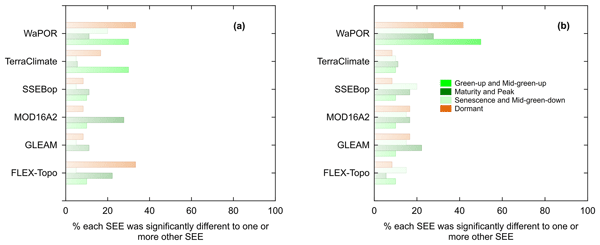
The fall and flushing of new leaves in the miombo woodlands co-occur in the dry season before the commencement of seasonal rainfall. The miombo species are also said to have access to soil moisture in deep soils, including groundwater in the dry season. Satellite-based evaporation estimates, temporal trends, and magnitudes differ the most in the dry season, most likely due to inadequate understanding and representation of the highlighted miombo species attributes in simulations.
Dominik Rains, Isabel Trigo, Emanuel Dutra, Sofia Ermida, Darren Ghent, Petra Hulsman, Jose Gómez-Dans, and Diego G. Miralles
Earth Syst. Sci. Data, 16, 567–593, https://doi.org/10.5194/essd-16-567-2024, https://doi.org/10.5194/essd-16-567-2024, 2024
Short summary
Short summary
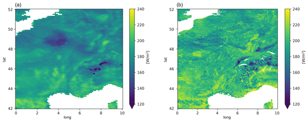
Land surface temperature and surface net radiation are vital inputs for many land surface and hydrological models. However, current remote sensing datasets of these variables come mostly at coarse resolutions, and the few high-resolution datasets available have large gaps due to cloud cover. Here, we present a continuous daily product for both variables across Europe for 2018–2019 obtained by combining observations from geostationary as well as polar-orbiting satellites.
Henry Zimba, Miriam Coenders-Gerrits, Kawawa Banda, Petra Hulsman, Nick van de Giesen, Imasiku Nyambe, and Hubert Savenije
Hydrol. Earth Syst. Sci. Discuss., https://doi.org/10.5194/hess-2022-114, https://doi.org/10.5194/hess-2022-114, 2022
Manuscript not accepted for further review
Short summary
Short summary
We compare performance of evaporation models in the Luangwa Basin located in a semi-arid and complex Miombo ecosystem in Africa. Miombo plants changes colour, drop off leaves and acquire new leaves during the dry season. In addition, the plant roots go deep in the soil and appear to access groundwater. Results show that evaporation models with structure and process that do not capture this unique plant structure and behaviour appears to have difficulties to correctly estimating evaporation.
Muhammad Ibrahim, Markus Hrachowitz, Miriam Coenders-Gerrits, and Ruud van der Ent
EGUsphere, https://doi.org/10.5194/egusphere-2026-4226, https://doi.org/10.5194/egusphere-2026-4226, 2026
This preprint is open for discussion and under review for Hydrology and Earth System Sciences (HESS).
Short summary
Short summary
Root zone storage capacity is an important parameter in hydrological and land-surface models and is often estimated using the memory method rather than through model calibration. We evaluated the uncertainty associated with this widely used method across thousands of catchments worldwide. Our results show that uncertainty varies systematically with climate, while memory method estimates remain in close agreement with calibrated values, supporting the commonly used 20-year return period.
Julia M. Rudlang, Thiago V. M. do Nascimento, Ruud van der Ent, Fabrizio Fenicia, and Markus Hrachowitz
Hydrol. Earth Syst. Sci., 30, 4481–4508, https://doi.org/10.5194/hess-30-4481-2026, https://doi.org/10.5194/hess-30-4481-2026, 2026
Short summary
Short summary
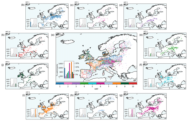
River flow (streamflow) behaviour varies across Europe and is shaped by climate and landscape. Using data from more than 7000 European catchments, we identified 10 hydrological response types based on flow magnitude, timing, and seasonality. At the continental scale, streamflow behaviour is mainly driven by climate, but landscape features are equally or more influential in several regions. These results show that streamflow behaviour emerges from the combined effects of climate and landscape.
Hatice Türk, Christine Stumpp, Markus Hrachowitz, Peter Strauss, Günter Blöschl, and Michael Stockinger
Hydrol. Earth Syst. Sci., 30, 1053–1076, https://doi.org/10.5194/hess-30-1053-2026, https://doi.org/10.5194/hess-30-1053-2026, 2026
Short summary
Short summary
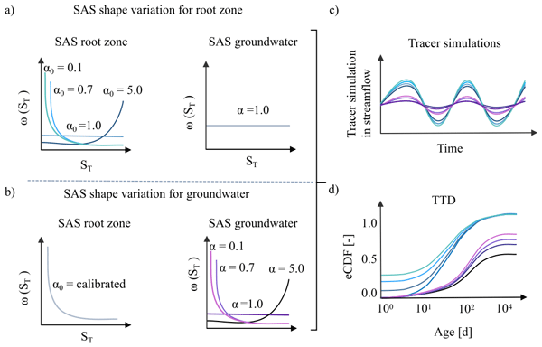
This study shows that streamflow isotope data in a catchment-scale isotope-based transport model were sufficient to isolate preferential flow in the unsaturated zone but insufficient to isolate the preferential release of young groundwater, as isotope signals were strongly damped by large passive groundwater storage. As a result, groundwater age-selection assumptions affected estimates of long transit times, making it difficult to quantify the fraction of stream water older than 100 days.
Thiago V. M. do Nascimento, Julia Rudlang, Sebastian Gnann, Jan Seibert, Markus Hrachowitz, and Fabrizio Fenicia
Hydrol. Earth Syst. Sci., 29, 7173–7200, https://doi.org/10.5194/hess-29-7173-2025, https://doi.org/10.5194/hess-29-7173-2025, 2025
Short summary
Short summary
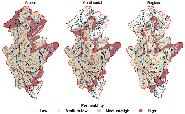
We show that geological maps with varying levels of detail may influence the identification of geology–streamflow relationships across European catchments at multiple scales. At the large scale, controls varied between basins, with no map consistently superior. At the intermediate and small scales, however, higher geological detail consistently strengthened correlations, particularly for baseflow signatures, with the regional map highlighting controls more consistent with process understanding.
Nathalie Rombeek, Markus Hrachowitz, and Remko Uijlenhoet
Hydrol. Earth Syst. Sci., 29, 6715–6733, https://doi.org/10.5194/hess-29-6715-2025, https://doi.org/10.5194/hess-29-6715-2025, 2025
Short summary
Short summary
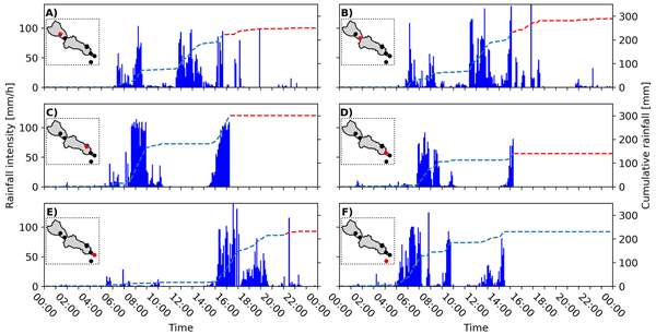
On 29 October 2024 Valencia (Spain) was struck by torrential rainfall, triggering devastating floods in this area. In this study, we quantify and describe the spatial and temporal structure of this rainfall event using personal weather stations (PWSs). These PWSs provide near real-time observations at a temporal resolution of ~5 min. This study shows the potential of PWSs for real-time rainfall monitoring and potentially flood early warning systems by complementing dedicated rain gauge networks.
Nathalie Rombeek, Markus Hrachowitz, Arjan Droste, and Remko Uijlenhoet
Hydrol. Earth Syst. Sci., 29, 4585–4606, https://doi.org/10.5194/hess-29-4585-2025, https://doi.org/10.5194/hess-29-4585-2025, 2025
Short summary
Short summary
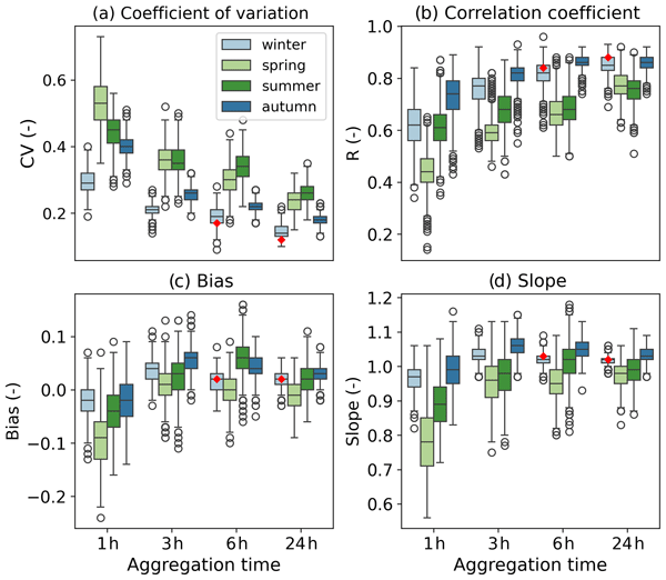
Rain gauge networks from personal weather stations (PWSs) have a network density 100 times higher than dedicated rain gauge networks in the Netherlands. However, PWSs are prone to several sources of error, as they are generally not installed and maintained according to international guidelines. This study systematically quantifies and describes the uncertainties arising from PWS rainfall estimates. In particular, the focus is on the highest rainfall accumulations.
Hatice Türk, Christine Stumpp, Markus Hrachowitz, Karsten Schulz, Peter Strauss, Günter Blöschl, and Michael Stockinger
Hydrol. Earth Syst. Sci., 29, 3935–3956, https://doi.org/10.5194/hess-29-3935-2025, https://doi.org/10.5194/hess-29-3935-2025, 2025
Short summary
Short summary
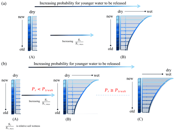
Using advances in transit time estimation and tracer data, we tested if fast-flow transit times are controlled solely by soil moisture or if they are also controlled by precipitation intensity. We used soil-moisture-dependent and precipitation-intensity-conditional transfer functions. We showed that a significant portion of event water bypasses the soil matrix through fast flow paths (overland flow, tile drains, preferential-flow paths) in dry soil conditions for both low- and high-intensity precipitation.
Magali Ponds, Sarah Hanus, Harry Zekollari, Marie-Claire ten Veldhuis, Gerrit Schoups, Roland Kaitna, and Markus Hrachowitz
Hydrol. Earth Syst. Sci., 29, 3545–3568, https://doi.org/10.5194/hess-29-3545-2025, https://doi.org/10.5194/hess-29-3545-2025, 2025
Short summary
Short summary
This research examines how future climate changes impact root zone storage, a key hydrological model parameter. Root zone storage – the soil water accessible to plants – adapts to climate but is often kept constant in models. We estimated climate-adapted storage in six Austrian Alps catchments. While storage increased, streamflow projections showed minimal change, which suggests that dynamic root zone representation is less critical in humid regions but warrants further study in arid areas.
Muhammad Ibrahim, Miriam Coenders-Gerrits, Ruud van der Ent, and Markus Hrachowitz
Hydrol. Earth Syst. Sci., 29, 1703–1723, https://doi.org/10.5194/hess-29-1703-2025, https://doi.org/10.5194/hess-29-1703-2025, 2025
Short summary
Short summary
The quantification of precipitation into evaporation and runoff is vital for water resources management. The Budyko framework, based on aridity and evaporative indices of a catchment, can be an ideal tool for that. However, recent research highlights deviations of catchments from the expected evaporative index, casting doubt on its reliability. This study quantifies deviations of 2387 catchments, finding them minor and predictable. Integrating these into predictions upholds the framework's efficacy.
Wouter R. Berghuijs, Ross A. Woods, Bailey J. Anderson, Anna Luisa Hemshorn de Sánchez, and Markus Hrachowitz
Hydrol. Earth Syst. Sci., 29, 1319–1333, https://doi.org/10.5194/hess-29-1319-2025, https://doi.org/10.5194/hess-29-1319-2025, 2025
Short summary
Short summary
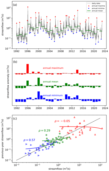
Water balances of catchments will often strongly depend on their state in the recent past, but such memory effects may persist at annual timescales. We use global data sets to show that annual memory is typically absent in precipitation but strong in terrestrial water stores and also present in evaporation and streamflow (including low flows and floods). Our experiments show that hysteretic models provide behaviour that is consistent with these observed memory behaviours.
Jordy Salmon-Monviola, Ophélie Fovet, and Markus Hrachowitz
Hydrol. Earth Syst. Sci., 29, 127–158, https://doi.org/10.5194/hess-29-127-2025, https://doi.org/10.5194/hess-29-127-2025, 2025
Short summary
Short summary
To increase the predictive power of hydrological models, it is necessary to improve their consistency, i.e. their physical realism, which is measured by the ability of the model to reproduce observed system dynamics. Using a model to represent the dynamics of water and nitrate and dissolved organic carbon concentrations in an agricultural catchment, we showed that using solute-concentration data for calibration is useful to improve the hydrological consistency of the model.
Nienke Tempel, Laurène Bouaziz, Riccardo Taormina, Ellis van Noppen, Jasper Stam, Eric Sprokkereef, and Markus Hrachowitz
Hydrol. Earth Syst. Sci., 28, 4577–4597, https://doi.org/10.5194/hess-28-4577-2024, https://doi.org/10.5194/hess-28-4577-2024, 2024
Short summary
Short summary
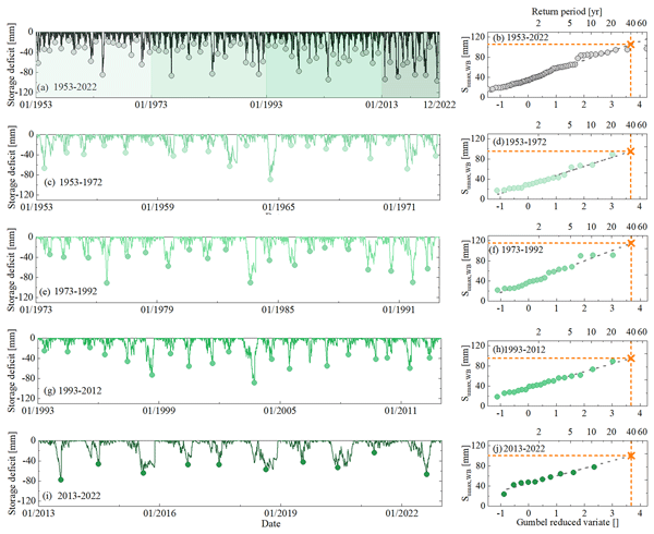
This study explores the impact of climatic variability on root zone water storage capacities and, thus, on hydrological predictions. Analysing data from 286 areas in Europe and the US, we found that, despite some variations in root zone storage capacity due to changing climatic conditions over multiple decades, these changes are generally minor and have a limited effect on water storage and river flow predictions.
Hongkai Gao, Markus Hrachowitz, Lan Wang-Erlandsson, Fabrizio Fenicia, Qiaojuan Xi, Jianyang Xia, Wei Shao, Ge Sun, and Hubert H. G. Savenije
Hydrol. Earth Syst. Sci., 28, 4477–4499, https://doi.org/10.5194/hess-28-4477-2024, https://doi.org/10.5194/hess-28-4477-2024, 2024
Short summary
Short summary
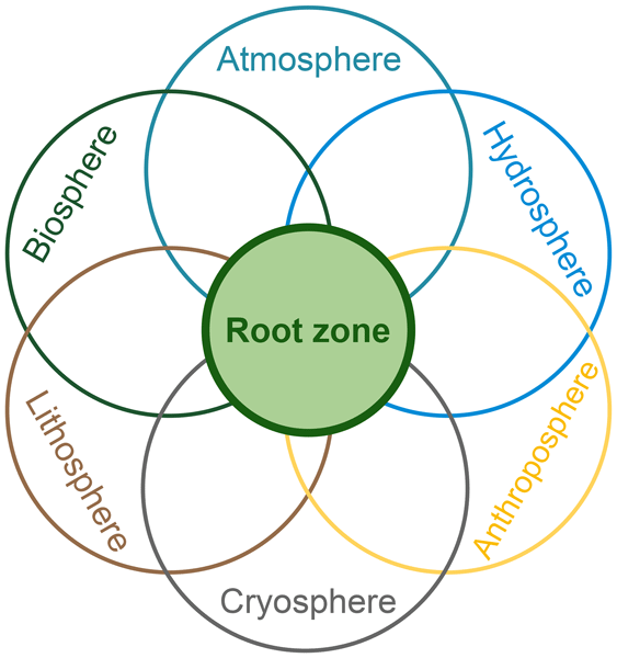
The concept of the root zone is widely used but lacks a precise definition. Its importance in Earth system science is not well elaborated upon. Here, we clarified its definition with several similar terms to bridge the multi-disciplinary gap. We underscore the key role of the root zone in the Earth system, which links the biosphere, hydrosphere, lithosphere, atmosphere, and anthroposphere. To better represent the root zone, we advocate for a paradigm shift towards ecosystem-centred modelling.
Siyuan Wang, Markus Hrachowitz, and Gerrit Schoups
Hydrol. Earth Syst. Sci., 28, 4011–4033, https://doi.org/10.5194/hess-28-4011-2024, https://doi.org/10.5194/hess-28-4011-2024, 2024
Short summary
Short summary
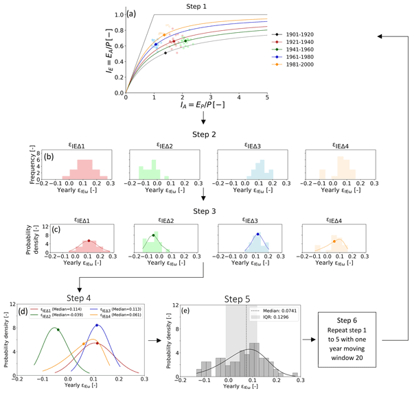
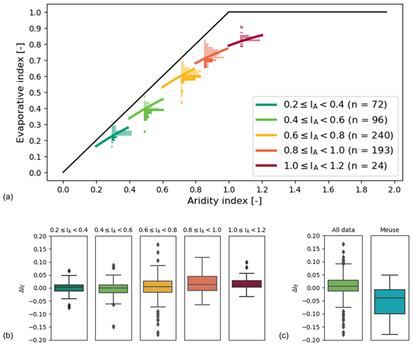
Root zone storage capacity (Sumax) changes significantly over multiple decades, reflecting vegetation adaptation to climatic variability. However, this temporal evolution of Sumax cannot explain long-term fluctuations in the partitioning of water fluxes as expressed by deviations ΔIE from the parametric Budyko curve over time with different climatic conditions, and it does not have any significant effects on shorter-term hydrological response characteristics of the upper Neckar catchment.
Henry M. Zimba, Miriam Coenders-Gerrits, Kawawa E. Banda, Petra Hulsman, Nick van de Giesen, Imasiku A. Nyambe, and Hubert H. G. Savenije
Hydrol. Earth Syst. Sci., 28, 3633–3663, https://doi.org/10.5194/hess-28-3633-2024, https://doi.org/10.5194/hess-28-3633-2024, 2024
Short summary
Short summary
The fall and flushing of new leaves in the miombo woodlands co-occur in the dry season before the commencement of seasonal rainfall. The miombo species are also said to have access to soil moisture in deep soils, including groundwater in the dry season. Satellite-based evaporation estimates, temporal trends, and magnitudes differ the most in the dry season, most likely due to inadequate understanding and representation of the highlighted miombo species attributes in simulations.
Fransje van Oorschot, Ruud J. van der Ent, Andrea Alessandri, and Markus Hrachowitz
Hydrol. Earth Syst. Sci., 28, 2313–2328, https://doi.org/10.5194/hess-28-2313-2024, https://doi.org/10.5194/hess-28-2313-2024, 2024
Short summary
Short summary
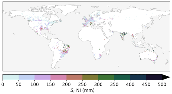
Vegetation plays a crucial role in regulating the water cycle by transporting water from the subsurface to the atmosphere via roots; this transport depends on the extent of the root system. In this study, we quantified the effect of irrigation on roots at a global scale. Our results emphasize the importance of accounting for irrigation in estimating the vegetation root extent, which is essential to adequately represent the water cycle in hydrological and climate models.
Hubert H. G. Savenije
Proc. IAHS, 385, 1–4, https://doi.org/10.5194/piahs-385-1-2024, https://doi.org/10.5194/piahs-385-1-2024, 2024
Short summary
Short summary
Hydrology is the bloodstream of the Earth, acting as a living organism, with the ecosystem as its active agent. The ecosystem optimises its survival within the constraints of energy, water, climate and nutrients. It is capable of adjusting the hydrological system and, through evolution, adjust its efficiency of carbon sequestration and moisture uptake. In trying to understand future functioning of hydrology, we have to take into account the adaptability of the ecosystem.
Jiaxing Liang, Hongkai Gao, Fabrizio Fenicia, Qiaojuan Xi, Yahui Wang, and Hubert H. G. Savenije
EGUsphere, https://doi.org/10.5194/egusphere-2024-550, https://doi.org/10.5194/egusphere-2024-550, 2024
Preprint archived
Short summary
Short summary
The root zone storage capacity (Sumax) is a key element in hydrology and land-atmospheric interaction. In this study, we utilized a hydrological model and a dynamic parameter identification method, to quantify the temporal trends of Sumax for 497 catchments in the USA. We found that 423 catchments (85 %) showed increasing Sumax, which averagely increased from 178 to 235 mm between 1980 and 2014. The increasing trend was also validated by multi-sources data and independent methods.
Dominik Rains, Isabel Trigo, Emanuel Dutra, Sofia Ermida, Darren Ghent, Petra Hulsman, Jose Gómez-Dans, and Diego G. Miralles
Earth Syst. Sci. Data, 16, 567–593, https://doi.org/10.5194/essd-16-567-2024, https://doi.org/10.5194/essd-16-567-2024, 2024
Short summary
Short summary
Land surface temperature and surface net radiation are vital inputs for many land surface and hydrological models. However, current remote sensing datasets of these variables come mostly at coarse resolutions, and the few high-resolution datasets available have large gaps due to cloud cover. Here, we present a continuous daily product for both variables across Europe for 2018–2019 obtained by combining observations from geostationary as well as polar-orbiting satellites.
Claire I. Michailovsky, Bert Coerver, Marloes Mul, and Graham Jewitt
Hydrol. Earth Syst. Sci., 27, 4335–4354, https://doi.org/10.5194/hess-27-4335-2023, https://doi.org/10.5194/hess-27-4335-2023, 2023
Short summary
Short summary
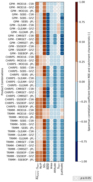
Many remote sensing products for precipitation, evapotranspiration, and water storage variations exist. However, when these are used with in situ runoff data in water balance closure studies, no single combination of products consistently outperforms others. We analyzed the water balance closure using different products in catchments worldwide and related the results to catchment characteristics. Our results can help identify the dataset combinations best suited for use in different catchments.
Fransje van Oorschot, Ruud J. van der Ent, Markus Hrachowitz, Emanuele Di Carlo, Franco Catalano, Souhail Boussetta, Gianpaolo Balsamo, and Andrea Alessandri
Earth Syst. Dynam., 14, 1239–1259, https://doi.org/10.5194/esd-14-1239-2023, https://doi.org/10.5194/esd-14-1239-2023, 2023
Short summary
Short summary
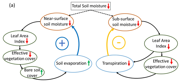
Vegetation largely controls land hydrology by transporting water from the subsurface to the atmosphere through roots and is highly variable in space and time. However, current land surface models have limitations in capturing this variability at a global scale, limiting accurate modeling of land hydrology. We found that satellite-based vegetation variability considerably improved modeled land hydrology and therefore has potential to improve climate predictions of, for example, droughts.
Siyuan Wang, Markus Hrachowitz, Gerrit Schoups, and Christine Stumpp
Hydrol. Earth Syst. Sci., 27, 3083–3114, https://doi.org/10.5194/hess-27-3083-2023, https://doi.org/10.5194/hess-27-3083-2023, 2023
Short summary
Short summary
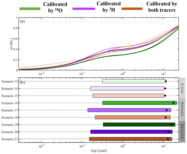
This study shows that previously reported underestimations of water ages are most likely not due to the use of seasonally variable tracers. Rather, these underestimations can be largely attributed to the choices of model approaches which rely on assumptions not frequently met in catchment hydrology. We therefore strongly advocate avoiding the use of this model type in combination with seasonally variable tracers and instead adopting StorAge Selection (SAS)-based or comparable model formulations.
Hubert T. Samboko, Sten Schurer, Hubert H. G. Savenije, Hodson Makurira, Kawawa Banda, and Hessel Winsemius
Geosci. Instrum. Method. Data Syst., 12, 155–169, https://doi.org/10.5194/gi-12-155-2023, https://doi.org/10.5194/gi-12-155-2023, 2023
Short summary
Short summary
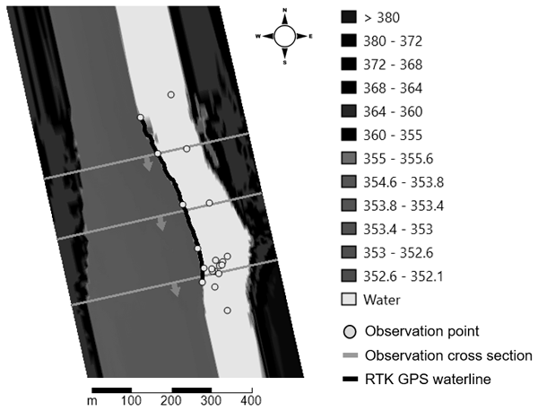
The study investigates how low-cost technology can be applied in data-scarce catchments to improve water resource management. More specifically, we investigate how drone technology can be combined with low-cost real-time kinematic positioning (RTK) global navigation satellite system (GNSS) equipment and subsequently applied to a 3D hydraulic model so as to generate more physically based rating curves.
Hongkai Gao, Fabrizio Fenicia, and Hubert H. G. Savenije
Hydrol. Earth Syst. Sci., 27, 2607–2620, https://doi.org/10.5194/hess-27-2607-2023, https://doi.org/10.5194/hess-27-2607-2023, 2023
Short summary
Short summary
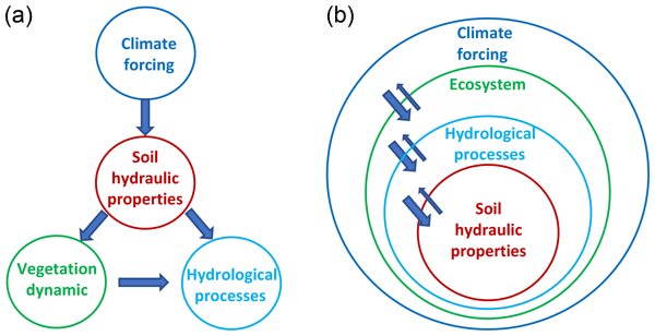
It is a deeply rooted perception that soil is key in hydrology. In this paper, we argue that it is the ecosystem, not the soil, that is in control of hydrology. Firstly, in nature, the dominant flow mechanism is preferential, which is not particularly related to soil properties. Secondly, the ecosystem, not the soil, determines the land–surface water balance and hydrological processes. Moving from a soil- to ecosystem-centred perspective allows more realistic and simpler hydrological models.
Dirk Eilander, Anaïs Couasnon, Frederiek C. Sperna Weiland, Willem Ligtvoet, Arno Bouwman, Hessel C. Winsemius, and Philip J. Ward
Nat. Hazards Earth Syst. Sci., 23, 2251–2272, https://doi.org/10.5194/nhess-23-2251-2023, https://doi.org/10.5194/nhess-23-2251-2023, 2023
Short summary
Short summary
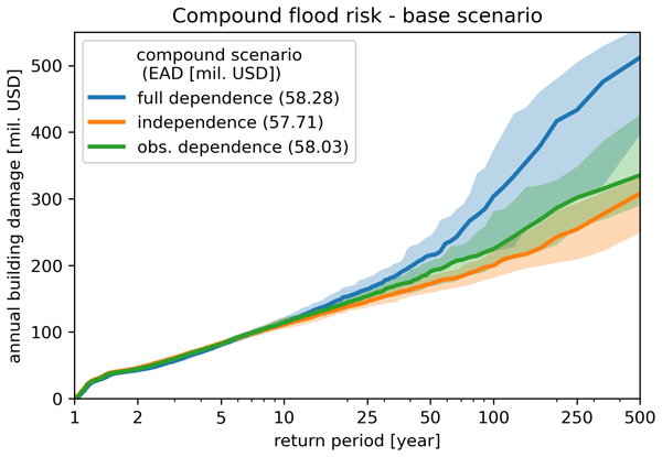
This study presents a framework for assessing compound flood risk using hydrodynamic, impact, and statistical modeling. A pilot in Mozambique shows the importance of accounting for compound events in risk assessments. We also show how the framework can be used to assess the effectiveness of different risk reduction measures. As the framework is based on global datasets and is largely automated, it can easily be applied in other areas for first-order assessments of compound flood risk.
Nutchanart Sriwongsitanon, Wasana Jandang, James Williams, Thienchart Suwawong, Ekkarin Maekan, and Hubert H. G. Savenije
Hydrol. Earth Syst. Sci., 27, 2149–2171, https://doi.org/10.5194/hess-27-2149-2023, https://doi.org/10.5194/hess-27-2149-2023, 2023
Short summary
Short summary
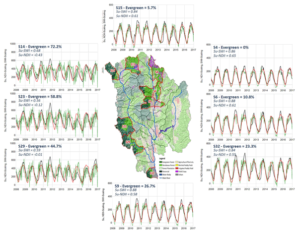
We developed predictive semi-distributed rainfall–runoff models for nested sub-catchments in the upper Ping basin, which yielded better or similar performance compared to calibrated lumped models. The normalised difference infrared index proves to be an effective proxy for distributed root zone moisture capacity over sub-catchments and is well correlated with the percentage of evergreen forest. In validation, soil moisture simulations appeared to be highly correlated with the soil wetness index.
Henry Zimba, Miriam Coenders-Gerrits, Kawawa Banda, Bart Schilperoort, Nick van de Giesen, Imasiku Nyambe, and Hubert H. G. Savenije
Hydrol. Earth Syst. Sci., 27, 1695–1722, https://doi.org/10.5194/hess-27-1695-2023, https://doi.org/10.5194/hess-27-1695-2023, 2023
Short summary
Short summary
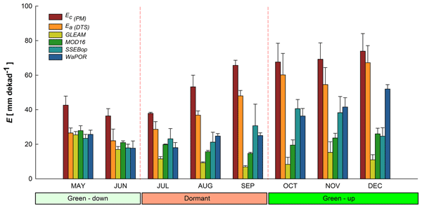
Miombo woodland plants continue to lose water even during the driest part of the year. This appears to be facilitated by the adapted features such as deep rooting (beyond 5 m) with access to deep soil moisture, potentially even ground water. It appears the trend and amount of water that the plants lose is correlated more to the available energy. This loss of water in the dry season by miombo woodland plants appears to be incorrectly captured by satellite-based evaporation estimates.
Dirk Eilander, Anaïs Couasnon, Tim Leijnse, Hiroaki Ikeuchi, Dai Yamazaki, Sanne Muis, Job Dullaart, Arjen Haag, Hessel C. Winsemius, and Philip J. Ward
Nat. Hazards Earth Syst. Sci., 23, 823–846, https://doi.org/10.5194/nhess-23-823-2023, https://doi.org/10.5194/nhess-23-823-2023, 2023
Short summary
Short summary
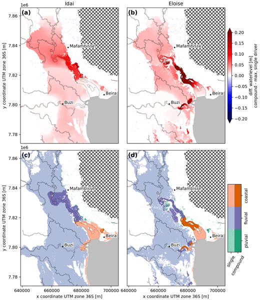
In coastal deltas, flooding can occur from interactions between coastal, riverine, and pluvial drivers, so-called compound flooding. Global models however ignore these interactions. We present a framework for automated and reproducible compound flood modeling anywhere globally and validate it for two historical events in Mozambique with good results. The analysis reveals differences in compound flood dynamics between both events related to the magnitude of and time lag between drivers.

Pau Wiersma, Jerom Aerts, Harry Zekollari, Markus Hrachowitz, Niels Drost, Matthias Huss, Edwin H. Sutanudjaja, and Rolf Hut
Hydrol. Earth Syst. Sci., 26, 5971–5986, https://doi.org/10.5194/hess-26-5971-2022, https://doi.org/10.5194/hess-26-5971-2022, 2022
Short summary
Short summary
We test whether coupling a global glacier model (GloGEM) with a global hydrological model (PCR-GLOBWB 2) leads to a more realistic glacier representation and to improved basin runoff simulations across 25 large-scale basins. The coupling does lead to improved glacier representation, mainly by accounting for glacier flow and net glacier mass loss, and to improved basin runoff simulations, mostly in strongly glacier-influenced basins, which is where the coupling has the most impact.
Judith Uwihirwe, Alessia Riveros, Hellen Wanjala, Jaap Schellekens, Frederiek Sperna Weiland, Markus Hrachowitz, and Thom A. Bogaard
Nat. Hazards Earth Syst. Sci., 22, 3641–3661, https://doi.org/10.5194/nhess-22-3641-2022, https://doi.org/10.5194/nhess-22-3641-2022, 2022
Short summary
Short summary
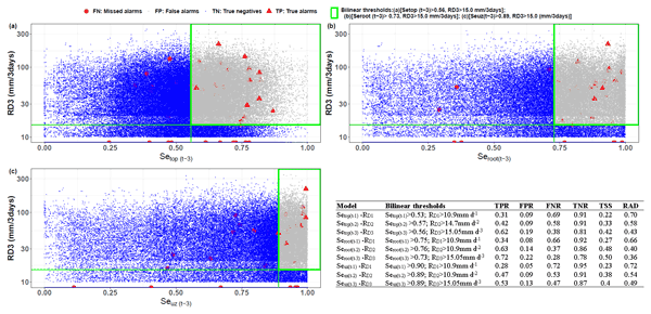
This study compared gauge-based and satellite-based precipitation products. Similarly, satellite- and hydrological model-derived soil moisture was compared to in situ soil moisture and used in landslide hazard assessment and warning. The results reveal the cumulative 3 d rainfall from the NASA-GPM to be the most effective landslide trigger. The modelled antecedent soil moisture in the root zone was the most informative hydrological variable for landslide hazard assessment and warning in Rwanda.
Hongkai Gao, Chuntan Han, Rensheng Chen, Zijing Feng, Kang Wang, Fabrizio Fenicia, and Hubert Savenije
Hydrol. Earth Syst. Sci., 26, 4187–4208, https://doi.org/10.5194/hess-26-4187-2022, https://doi.org/10.5194/hess-26-4187-2022, 2022
Short summary
Short summary
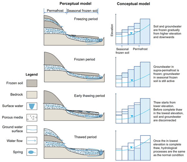
Frozen soil hydrology is one of the 23 unsolved problems in hydrology (UPH). In this study, we developed a novel conceptual frozen soil hydrological model, FLEX-Topo-FS. The model successfully reproduced the soil freeze–thaw process, and its impacts on hydrologic connectivity, runoff generation, and groundwater. We believe this study is a breakthrough for the 23 UPH, giving us new insights on frozen soil hydrology, with broad implications for predicting cold region hydrology in future.
Judith Uwihirwe, Markus Hrachowitz, and Thom Bogaard
Nat. Hazards Earth Syst. Sci., 22, 1723–1742, https://doi.org/10.5194/nhess-22-1723-2022, https://doi.org/10.5194/nhess-22-1723-2022, 2022
Short summary
Short summary
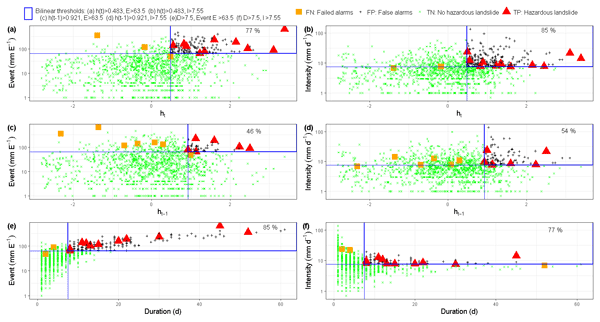
This research tested the value of regional groundwater level information to improve landslide predictions with empirical models based on the concept of threshold levels. In contrast to precipitation-based thresholds, the results indicated that relying on threshold models exclusively defined using hydrological variables such as groundwater levels can lead to improved landslide predictions due to their implicit consideration of long-term antecedent conditions until the day of landslide occurrence.
Henry Zimba, Miriam Coenders-Gerrits, Kawawa Banda, Petra Hulsman, Nick van de Giesen, Imasiku Nyambe, and Hubert Savenije
Hydrol. Earth Syst. Sci. Discuss., https://doi.org/10.5194/hess-2022-114, https://doi.org/10.5194/hess-2022-114, 2022
Manuscript not accepted for further review
Short summary
Short summary
We compare performance of evaporation models in the Luangwa Basin located in a semi-arid and complex Miombo ecosystem in Africa. Miombo plants changes colour, drop off leaves and acquire new leaves during the dry season. In addition, the plant roots go deep in the soil and appear to access groundwater. Results show that evaporation models with structure and process that do not capture this unique plant structure and behaviour appears to have difficulties to correctly estimating evaporation.
Elisa Ragno, Markus Hrachowitz, and Oswaldo Morales-Nápoles
Hydrol. Earth Syst. Sci., 26, 1695–1711, https://doi.org/10.5194/hess-26-1695-2022, https://doi.org/10.5194/hess-26-1695-2022, 2022
Short summary
Short summary
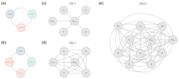
We explore the ability of non-parametric Bayesian networks to reproduce maximum daily discharge in a given month in a catchment when the remaining hydro-meteorological and catchment attributes are known. We show that a saturated network evaluated in an individual catchment can reproduce statistical characteristics of discharge in about ~ 40 % of the cases, while challenges remain when a saturated network considering all the catchments together is evaluated.
Laurène J. E. Bouaziz, Emma E. Aalbers, Albrecht H. Weerts, Mark Hegnauer, Hendrik Buiteveld, Rita Lammersen, Jasper Stam, Eric Sprokkereef, Hubert H. G. Savenije, and Markus Hrachowitz
Hydrol. Earth Syst. Sci., 26, 1295–1318, https://doi.org/10.5194/hess-26-1295-2022, https://doi.org/10.5194/hess-26-1295-2022, 2022
Short summary
Short summary
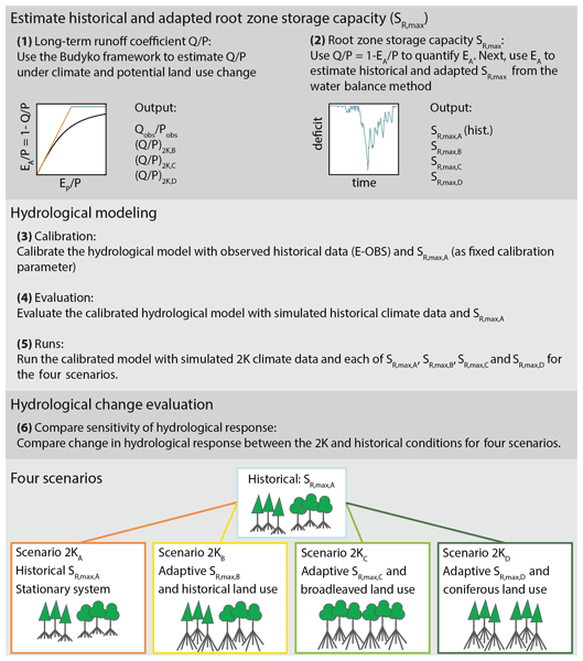
Assuming stationarity of hydrological systems is no longer appropriate when considering land use and climate change. We tested the sensitivity of hydrological predictions to changes in model parameters that reflect ecosystem adaptation to climate and potential land use change. We estimated a 34 % increase in the root zone storage parameter under +2 K global warming, resulting in up to 15 % less streamflow in autumn, due to 14 % higher summer evaporation, compared to a stationary system.
Hubert T. Samboko, Sten Schurer, Hubert H. G. Savenije, Hodson Makurira, Kawawa Banda, and Hessel Winsemius
Geosci. Instrum. Method. Data Syst., 11, 1–23, https://doi.org/10.5194/gi-11-1-2022, https://doi.org/10.5194/gi-11-1-2022, 2022
Short summary
Short summary
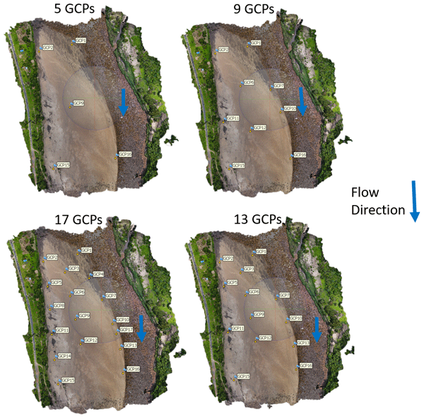
The study was conducted along the Luangwa River in Zambia. It combines low-cost instruments such as UAVs and GPS kits to collect data for the purposes of water management. A novel technique which seamlessly merges the dry and wet bathymetry before application in a hydraulic model was applied. Successful implementation resulted in water authorities with small budgets being able to monitor flows safely and efficiently without significant compromise on accuracy.
Dirk Eilander, Willem van Verseveld, Dai Yamazaki, Albrecht Weerts, Hessel C. Winsemius, and Philip J. Ward
Hydrol. Earth Syst. Sci., 25, 5287–5313, https://doi.org/10.5194/hess-25-5287-2021, https://doi.org/10.5194/hess-25-5287-2021, 2021
Short summary
Short summary
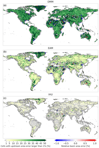
Digital elevation models and derived flow directions are crucial to distributed hydrological modeling. As the spatial resolution of models is typically coarser than these data, we need methods to upscale flow direction data while preserving the river structure. We propose the Iterative Hydrography Upscaling (IHU) method and show it outperforms other often-applied methods. We publish the multi-resolution MERIT Hydro IHU hydrography dataset and the algorithm as part of the pyflwdir Python package.
Cited articles
Abas, I.:
Remote river rating in Zambia: A case study in the Luangwa river basin,
Master of Science, Civil Engineering and Geosciences,
Delft University of Technology, Delft, the Netherlands, 2018.
Ajami, N. K., Gupta, H., Wagener, T., and Sorooshian, S.:
Calibration of a semi-distributed hydrologic model for streamflow estimation along a river system,
J. Hydrol.,
298, 112–135, https://doi.org/10.1016/j.jhydrol.2004.03.033, 2004.
Bai, P., Liu, X., and Liu, C.:
Improving hydrological simulations by incorporating GRACE data for model calibration,
J. Hydrol.,
557, 291–304, https://doi.org/10.1016/j.jhydrol.2017.12.025, 2018.
Bauer-Gottwein, P., Jensen, I. H., Guzinski, R., Bredtoft, G. K. T., Hansen, S., and Michailovsky, C. I.: Operational river discharge forecasting in poorly gauged basins: the Kavango River basin case study, Hydrol. Earth Syst. Sci., 19, 1469–1485, https://doi.org/10.5194/hess-19-1469-2015, 2015.
Beilfuss, R. and dos Santos, D.:
Patterns of Hydrological Change in the Zambezi Delta, Mozambique,
in: Working Paper #2 Program for the Sustainable Management of Cahora Bassa Dam and the Lower Zambezi Valley, International Crane Foundation, Sofala, Mozambique, 2001.
Beven, K. J.:
A manifesto for the equifinality thesis,
J. Hydrol.,
320, 18–36, https://doi.org/10.1016/j.jhydrol.2005.07.007, 2006.
Beven, K. J.:
On doing better hydrological science,
Hydrol. Process.,
22, 3549–3553, https://doi.org/10.1002/hyp.7108, 2008.
Beven, K. J.:
Preferential flows and travel time distributions: defining adequate hypothesis tests for hydrological process models,
Hydrol. Process.,
24, 1537–1547, https://doi.org/10.1002/hyp.7718, 2010.
Beven, K. J. and Westerberg, I.:
On red herrings and real herrings: disinformation and information in hydrological inference,
Hydrol. Process.,
25, 1676–1680, https://doi.org/10.1002/hyp.7963, 2011.
Biancamaria, S., Lettenmaier, D. P., and Pavelsky, T. M.:
The SWOT Mission and Its Capabilities for Land Hydrology,
Surv. Geophys.,
37, 307–337, https://doi.org/10.1007/s10712-015-9346-y, 2016.
Biancamaria, S., Frappart, F., Leleu, A. S., Marieu, V., Blumstein, D., Desjonquères, J.-D., Boy, F., Sottolichio, A., and Valle-Levinson, A.:
Satellite radar altimetry water elevations performance over a 200 m wide river: Evaluation over the Garonne River,
Adv. Space Res.,
59, 128–146, https://doi.org/10.1016/j.asr.2016.10.008, 2017.
Birkett, C. M.:
Contribution of the TOPEX NASA Radar Altimeter to the global monitoring of large rivers and wetlands,
Water Resour. Res.,
34, 1223–1239, https://doi.org/10.1029/98WR00124, 1998.
Blazquez, A., Meyssignac, B., Lemoine, J. M., Berthier, E., Ribes, A., and Cazenave, A.:
Exploring the uncertainty in GRACE estimates of the mass redistributions at the Earth surface: implications for the global water and sea level budgets,
Geophys. J. Int.,
215, 415–430, https://doi.org/10.1093/gji/ggy293, 2018.
Calmant, S., Seyler, F., and Cretaux, J.:
Monitoring Continental Surface Waters by Satellite Altimetry,
Surv. Geophys.,
29, 247–269, 2009.
Chow, V. T.:
Open-channel hydraulics,
McGraw-Hill, New York, 1959.
Clark, M. P., Nijssen, B., Lundquist, J. D., Kavetski, D., Rupp, D. E., Woods, R. A., Freer, J. E., Gutmann, E. D., Wood, A. W., Gochis, D. J., Rasmussen, R. M., Tarboton, D. G., Mahat, V., Flerchinger, G. N., and Marks, D. G.:
A unified approach for process-based hydrologic modeling: 2. Model implementation and case studies,
Water Resour. Res.,
51, 2515–2542, https://doi.org/10.1002/2015WR017200, 2015.
Clark, M. P., Schaefli, B., Schymanski, S. J., Samaniego, L., Luce, C. H., Jackson, B. M., Freer, J. E., Arnold, J. R., Moore, R. D., Istanbulluoglu, E., and Ceola, S.:
Improving the theoretical underpinnings of process-based hydrologic models,
Water Resour. Res.,
52, 2350–2365, https://doi.org/10.1002/2015WR017910, 2016.
CNES: AVISO+ Satellite Altimetry Data, available at: https://www.aviso.altimetry.fr, last access: January 2018.
Danielson, J. J. and Gesch, D. B.:
Global multi-resolution terrain elevation data 2010 (GMTED2010), Report 2011-1073,
US Geological Survey, Reston, Virginia,
https://doi.org/10.3133/ofr20111073, 2011.
Dembélé, M., Hrachowitz, M., Savenije, H. H. G., Mariéthoz, G., and Schaefli, B.:
Improving the Predictive Skill of a Distributed Hydrological Model by Calibration on Spatial Patterns With Multiple Satellite Data Sets,
Water Resour. Res.,
56, e2019WR026085, https://doi.org/10.1029/2019WR026085, 2020.
Demirel, M. C., Mai, J., Mendiguren, G., Koch, J., Samaniego, L., and Stisen, S.: Combining satellite data and appropriate objective functions for improved spatial pattern performance of a distributed hydrologic model, Hydrol. Earth Syst. Sci., 22, 1299–1315, https://doi.org/10.5194/hess-22-1299-2018, 2018.
de Oliveira Campos, I., Mercier, F., Maheu, C., Cochonneau, G., Kosuth, P., Blitzkow, D., and Cazenave, A.:
Temporal variations of river basin waters from Topex/Poseidon satellite altimetry. Application to the Amazon basin,
Comptes Rendus de l'Académie des Sciences – Series IIA – Earth and Planetary Science,
333, 633–643, https://doi.org/10.1016/S1251-8050(01)01688-3, 2001.
Domeneghetti, A.:
On the use of SRTM and altimetry data for flood modeling in data-sparse regions,
Water Resour. Res.,
52, 2901–2918, https://doi.org/10.1002/2015WR017967, 2016.
Domeneghetti, A., Castellarin, A., Tarpanelli, A., and Moramarco, T.:
Investigating the uncertainty of satellite altimetry products for hydrodynamic modelling,
Hydrol. Process.,
29, 4908–4918, https://doi.org/10.1002/hyp.10507, 2015.
Drusch, M., Del Bello, U., Carlier, S., Colin, O., Fernandez, V., Gascon, F., Hoersch, B., Isola, C., Laberinti, P., Martimort, P., Meygret, A., Spoto, F., Sy, O., Marchese, F., and Bargellini, P.:
Sentinel-2: ESA's Optical High-Resolution Mission for GMES Operational Services,
Remote Sens. Environ.,
120, 25–36, https://doi.org/10.1016/j.rse.2011.11.026, 2012.
Entwistle, N. S. and Heritage, G. L.:
Small unmanned aerial model accuracy for photogrammetrical fluvial bathymetric survey,
J. Appl. Remote Sens.,
13, 1–19, 19, 2019.
ESA: Satellite Missions Database, available at: https://directory.eoportal.org/web/eoportal/satellite-missions, last access: January 2018.
ESA and UCLouvian: GlobCover 2009, available at: http://due.esrin.esa.int/page_globcover.php (last access: June 2020), 2010.
Euser, T., Winsemius, H. C., Hrachowitz, M., Fenicia, F., Uhlenbrook, S., and Savenije, H. H. G.: A framework to assess the realism of model structures using hydrological signatures, Hydrol. Earth Syst. Sci., 17, 1893–1912, https://doi.org/10.5194/hess-17-1893-2013, 2013.
Euser, T., Hrachowitz, M., Winsemius, H. C., and Savenije, H. H. G.:
The effect of forcing and landscape distribution on performance and consistency of model structures,
Hydrol. Process.,
29, 3727–3743, https://doi.org/10.1002/hyp.10445, 2015.
Fang, K., Shen, C., Fisher, J. B., and Niu, J.:
Improving Budyko curve-based estimates of long-term water partitioning using hydrologic signatures from GRACE,
Water Resour. Res.,
52, 5537–5554, https://doi.org/10.1002/2016WR018748, 2016.
Fleischmann, A., Siqueira, V., Paris, A., Collischonn, W., Paiva, R., Pontes, P., Crétaux, J. F., Bergé-Nguyen, M., Biancamaria, S., Gosset, M., Calmant, S., and Tanimoun, B.:
Modelling hydrologic and hydrodynamic processes in basins with large semi-arid wetlands,
J. Hydrol.,
561, 943–959, https://doi.org/10.1016/j.jhydrol.2018.04.041, 2018.
Forootan, E., Khaki, M., Schumacher, M., Wulfmeyer, V., Mehrnegar, N., van Dijk, A. I. J. M., Brocca, L., Farzaneh, S., Akinluyi, F., Ramillien, G., Shum, C. K., Awange, J., and Mostafaie, A.:
Understanding the global hydrological droughts of 2003–2016 and their relationships with teleconnections,
Sci. Total Environ.,
650, 2587–2604, https://doi.org/10.1016/j.scitotenv.2018.09.231, 2019.
Fovet, O., Ruiz, L., Hrachowitz, M., Faucheux, M., and Gascuel-Odoux, C.: Hydrological hysteresis and its value for assessing process consistency in catchment conceptual models, Hydrol. Earth Syst. Sci., 19, 105–123, https://doi.org/10.5194/hess-19-105-2015, 2015.
Frappart, F., Papa, F., Marieu, V., Malbeteau, Y., Jordy, F., Calmant, S., Durand, F., and Bala, S.:
Preliminary Assessment of SARAL/AltiKa Observations over the Ganges-Brahmaputra and Irrawaddy Rivers,
Mar. Geod.,
38, 568–580, https://doi.org/10.1080/01490419.2014.990591, 2015.
Freer, J., Beven, K., and Ambroise, B.:
Bayesian Estimation of Uncertainty in Runoff Prediction and the Value of Data: An Application of the GLUE Approach,
Water Resour. Res.,
32, 2161–2173, https://doi.org/10.1029/95WR03723, 1996.
Funk, C. C., Peterson, P. J., Landsfeld, M. F., Pedreros, D. H., Verdin, J. P., Rowland, J. D., Romero, B. E., Husak, G. J., Michaelsen, J. C., and Verdin, A. P.:
A quasi-global precipitation time series for drought monitoring,
US Geological Survey, Data Series 832, 4, available at:
ftp://chg-ftpout.geog.ucsb.edu/pub/org/chg/products/CHIRPS-2.0/docs/USGS-DS832.CHIRPS.pdf (last access: June 2020), 2014.
Gao, H., Hrachowitz, M., Fenicia, F., Gharari, S., and Savenije, H. H. G.: Testing the realism of a topography-driven model (FLEX-Topo) in the nested catchments of the Upper Heihe, China, Hydrol. Earth Syst. Sci., 18, 1895–1915, https://doi.org/10.5194/hess-18-1895-2014, 2014.
Gao, H., Hrachowitz, M., Sriwongsitanon, N., Fenicia, F., Gharari, S., and Savenije, H. H. G.:
Accounting for the influence of vegetation and landscape improves model transferability in a tropical savannah region,
Water Resour. Res.,
52, 7999–8022, https://doi.org/10.1002/2016WR019574, 2016.
Garambois, P.-A., Calmant, S., Roux, H., Paris, A., Monnier, J., Finaud-Guyot, P., Samine Montazem, A., and Santos da Silva, J.:
Hydraulic visibility: Using satellite altimetry to parameterize a hydraulic model of an ungauged reach of a braided river,
Hydrol. Process.,
31, 756–767, https://doi.org/10.1002/hyp.11033, 2017.
Garavaglia, F., Le Lay, M., Gottardi, F., Garçon, R., Gailhard, J., Paquet, E., and Mathevet, T.: Impact of model structure on flow simulation and hydrological realism: from a lumped to a semi-distributed approach, Hydrol. Earth Syst. Sci., 21, 3937–3952, https://doi.org/10.5194/hess-21-3937-2017, 2017.
Getirana, A. C. V.:
Integrating spatial altimetry data into the automatic calibration of hydrological models,
J. Hydrol.,
387, 244–255, https://doi.org/10.1016/j.jhydrol.2010.04.013, 2010.
Getirana, A. C. V. and Peters-Lidard, C.: Estimating water discharge from large radar altimetry datasets, Hydrol. Earth Syst. Sci., 17, 923–933, https://doi.org/10.5194/hess-17-923-2013, 2013.
Getirana, A. C. V., Bonnet, M.-P., Calmant, S., Roux, E., Rotunno Filho, O. C., and Mansur, W. J.:
Hydrological monitoring of poorly gauged basins based on rainfall–runoff modeling and spatial altimetry,
J. Hydrol.,
379, 205–219, https://doi.org/10.1016/j.jhydrol.2009.09.049, 2009.
Getirana, A. C. V., Bonnet, M. P., Rotunno Filho, O. C., Collischonn, W., Guyot, J. L., Seyler, F., and Mansur, W. J.:
Hydrological modelling and water balance of the Negro River basin: evaluation based on in situ and spatial altimetry data,
Hydrol. Process.,
24, 3219–3236, https://doi.org/10.1002/hyp.7747, 2010.
Gharari, S., Hrachowitz, M., Fenicia, F., and Savenije, H. H. G.: Hydrological landscape classification: investigating the performance of HAND based landscape classifications in a central European meso-scale catchment, Hydrol. Earth Syst. Sci., 15, 3275–3291, https://doi.org/10.5194/hess-15-3275-2011, 2011.
Gharari, S., Hrachowitz, M., Fenicia, F., and Savenije, H. H. G.: An approach to identify time consistent model parameters: sub-period calibration, Hydrol. Earth Syst. Sci., 17, 149–161, https://doi.org/10.5194/hess-17-149-2013, 2013.
Gharari, S., Hrachowitz, M., Fenicia, F., Gao, H., and Savenije, H. H. G.: Using expert knowledge to increase realism in environmental system models can dramatically reduce the need for calibration, Hydrol. Earth Syst. Sci., 18, 4839–4859, https://doi.org/10.5194/hess-18-4839-2014, 2014.
Gichamo, T. Z., Popescu, I., Jonoski, A., and Solomatine, D.:
River cross-section extraction from the ASTER global DEM for flood modeling,
Environ. Modell. Softw.,
31, 37–46, https://doi.org/10.1016/j.envsoft.2011.12.003, 2012.
Google Earth: V 7.3.2: Zambia, Elevation Profile, available at: https://www.google.com/earth/versions/#download-pro, last access: September 2018.
Gupta, H. V., Wagener, T., and Liu, Y.:
Reconciling theory with observations: elements of a diagnostic approach to model evaluation,
Hydrol. Process.,
22, 3802–3813, https://doi.org/10.1002/hyp.6989, 2008.
Hanlon, J.: Floods displace thousands in Mozambique, available at: https://www.theguardian.com/world/2001/mar/28/mozambique.unitednations (last access: January 2017), 2001.
Hargreaves, G. H. and Allen, R. G.:
History and evaluation of hargreaves evapotranspiration equation,
J. Irrig. Drain. Eng.,
129, 53–63, https://doi.org/10.1061/(ASCE)0733-9437(2003)129:1(53), 2003.
Hargreaves, G. H. and Samani, Z. A.:
Reference Crop Evapotranspiration from Temperature,
Appl. Eng. Agric.,
1, 96–99, https://doi.org/10.13031/2013.26773, 1985.
Hasan, M. A. and Pradhanang, S. M.:
Estimation of flow regime for a spatially varied Himalayan watershed using improved multi-site calibration of the Soil and Water Assessment Tool (SWAT) model,
Environ. Earth Sci.,
76, 787, https://doi.org/10.1007/s12665-017-7134-3, 2017.
Hou, J., van Dijk, A. I. J. M., Renzullo, L. J., and Vertessy, R. A.: Using modelled discharge to develop satellite-based river gauging: a case study for the Amazon Basin, Hydrol. Earth Syst. Sci., 22, 6435–6448, https://doi.org/10.5194/hess-22-6435-2018, 2018.
Hrachowitz, M. and Clark, M. P.: HESS Opinions: The complementary merits of competing modelling philosophies in hydrology, Hydrol. Earth Syst. Sci., 21, 3953–3973, https://doi.org/10.5194/hess-21-3953-2017, 2017.
Hrachowitz, M., Savenije, H. H. G., Blöschl, G., McDonnell, J. J., Sivapalan, M., Pomeroy, J. W., Arheimer, B., Blume, T., Clark, M. P., Ehret, U., Fenicia, F., Freer, J. E., Gelfan, A., Gupta, H. V., Hughes, D. A., Hut, R. W., Montanari, A., Pande, S., Tetzlaff, D., Troch, P. A., Uhlenbrook, S., Wagener, T., Winsemius, H. C., Woods, R. A., Zehe, E., and Cudennec, C.:
A decade of Predictions in Ungauged Basins (PUB) – a review,
Hydrolog. Sci. J.,
58, 1198–1255, https://doi.org/10.1080/02626667.2013.803183, 2013.
Hrachowitz, M., Fovet, O., Ruiz, L., Euser, T., Gharari, S., Nijzink, R., Freer, J., Savenije, H. H. G., and Gascuel-Odoux, C.:
Process consistency in models: The importance of system signatures, expert knowledge, and process complexity,
Water Resour. Res.,
50, 7445–7469, https://doi.org/10.1002/2014WR015484, 2014.
Huang, Q., Long, D., Du, M., Zeng, C., Qiao, G., Li, X., Hou, A., and Hong, Y.:
Discharge estimation in high-mountain regions with improved methods using multisource remote sensing: A case study of the Upper Brahmaputra River,
Remote Sens. Environ.,
219, 115–134, https://doi.org/10.1016/j.rse.2018.10.008, 2018.
Hulsman, P., Bogaard, T. A., and Savenije, H. H. G.: Rainfall-runoff modelling using river-stage time series in the absence of reliable discharge information: a case study in the semi-arid Mara River basin, Hydrol. Earth Syst. Sci., 22, 5081–5095, https://doi.org/10.5194/hess-22-5081-2018, 2018.
Irons, J. R., Dwyer, J. L., and Barsi, J. A.:
The next Landsat satellite: The Landsat Data Continuity Mission,
Remote Sens. Environ.,
122, 11–21, https://doi.org/10.1016/j.rse.2011.08.026, 2012.
Jakeman, A. J. and Hornberger, G. M.:
How much complexity is warranted in a rainfall-runoff model?,
Water Resour. Res.,
29, 2637–2649, https://doi.org/10.1029/93WR00877, 1993.
Jian, J., Ryu, D., Costelloe, J. F., and Su, C.-H.:
Towards hydrological model calibration using river level measurements,
J. Hydrol.: Reg. Stud.,
10, 95–109, https://doi.org/10.1016/j.ejrh.2016.12.085, 2017.
Jiang, L., Schneider, R., Andersen, O. B., and Bauer-Gottwein, P.:
CryoSat-2 altimetry applications over rivers and lakes,
Water (Switzerland),
9, 211, https://doi.org/10.3390/w9030211, 2017.
Khaki, M. and Awange, J.:
The application of multi-mission satellite data assimilation for studying water storage changes over South America,
Sci. Total Environ.,
647, 1557–1572, https://doi.org/10.1016/j.scitotenv.2018.08.079, 2019.
Kittel, C. M. M., Nielsen, K., Tøttrup, C., and Bauer-Gottwein, P.: Informing a hydrological model of the Ogooué with multi-mission remote sensing data, Hydrol. Earth Syst. Sci., 22, 1453–1472, https://doi.org/10.5194/hess-22-1453-2018, 2018.
KlemeŠ, V.:
Operational testing of hydrological simulation models,
Hydrolog. Sci. J.,
31, 13–24, https://doi.org/10.1080/02626668609491024, 1986.
Knutti, R.:
Should we believe model predictions of future climate change?,
Philos. T. Roy. Soc. A,
366, 4647–4664, https://doi.org/10.1098/rsta.2008.0169, 2008.
Kouraev, A. V., Zakharova, E. A., Samain, O., Mognard, N. M., and Cazenave, A.:
Ob' river discharge from TOPEX/Poseidon satellite altimetry (1992–2002),
Remote Sens. Environ.,
93, 238–245, https://doi.org/10.1016/j.rse.2004.07.007, 2004.
Lakshmi, V.:
The role of satellite remote sensing in the Prediction of Ungauged Basins,
Hydrol. Process.,
18, 1029–1034, https://doi.org/10.1002/hyp.5520, 2004.
Landerer, F. W. and Swenson, S. C.:
Accuracy of scaled GRACE terrestrial water storage estimates,
Water Resour. Res.,
48, W04531, https://doi.org/10.1029/2011WR011453, 2012.
Langhorst, T., Pavelsky, T. M., Frasson, R. P. d. M., Wei, R., Domeneghetti, A., Altenau, E. H., Durand, M. T., Minear, J. T., Wegmann, K. W., and Fuller, M. R.:
Anticipated Improvements to River Surface Elevation Profiles From the Surface Water and Ocean Topography Mission,
Front. Earth Sci.,
7, 102, https://doi.org/10.3389/feart.2019.00102, 2019.
Le Coz, C. and van de Giesen, N.: Comparison of Rainfall Products over Sub-Saharan Africa, J. Hydrometeorol., 21, 553–596, https://doi.org/10.1175/JHM-D-18-0256.1, 2020.
Leon, J. G., Calmant, S., Seyler, F., Bonnet, M. P., Cauhopé, M., Frappart, F., Filizola, N., and Fraizy, P.:
Rating curves and estimation of average water depth at the upper Negro River based on satellite altimeter data and modeled discharges,
J. Hydrol.,
328, 481–496, https://doi.org/10.1016/j.jhydrol.2005.12.006, 2006.
Liu, G., Schwartz, F. W., Tseng, K. H., and Shum, C. K.:
Discharge and water-depth estimates for ungauged rivers: Combining hydrologic, hydraulic, and inverse modeling with stage and water-area measurements from satellites,
Water Resour. Res.,
51, 6017–6035, https://doi.org/10.1002/2015WR016971, 2015.
Łyszkowicz, A. B. and Bernatowicz, A.:
Current state of art of satellite altimetry,
Geod. Cartogr.,
66, 259–270, https://doi.org/10.1515/geocart-2017-0016, 2017.
Manning, R.:
On the flow of water in open channels and pipes,
T. Inst. Civ. Eng. Ireland,
20, 161–207, 1891.
McCuen Richard, H., Knight, Z., and Cutter, A. G.:
Evaluation of the Nash–Sutcliffe Efficiency Index,
J. Hydrol. Eng.,
11, 597–602, https://doi.org/10.1061/(ASCE)1084-0699(2006)11:6(597), 2006.
McMillan, H. K. and Westerberg, I. K.:
Rating curve estimation under epistemic uncertainty,
Hydrol. Process.,
29, 1873–1882, https://doi.org/10.1002/hyp.10419, 2015.
McMillan, H. K., Westerberg, I., and Branger, F.:
Five guidelines for selecting hydrological signatures,
Hydrol. Process.,
31, 4757–4761, https://doi.org/10.1002/hyp.11300, 2017.
Michailovsky, C. I. and Bauer-Gottwein, P.: Operational reservoir inflow forecasting with radar altimetry: the Zambezi case study, Hydrol. Earth Syst. Sci., 18, 997–1007, https://doi.org/10.5194/hess-18-997-2014, 2014.
Michailovsky, C. I., McEnnis, S., Berry, P. A. M., Smith, R., and Bauer-Gottwein, P.: River monitoring from satellite radar altimetry in the Zambezi River basin, Hydrol. Earth Syst. Sci., 16, 2181–2192, https://doi.org/10.5194/hess-16-2181-2012, 2012.
Michailovsky, C. I., Milzow, C., and Bauer-Gottwein, P.:
Assimilation of radar altimetry to a routing model of the Brahmaputra River,
Water Resour. Res.,
49, 4807–4816, https://doi.org/10.1002/wrcr.20345, 2013.
Montanari, M., Hostache, R., Matgen, P., Schumann, G., Pfister, L., and Hoffmann, L.: Calibration and sequential updating of a coupled hydrologic-hydraulic model using remote sensing-derived water stages, Hydrol. Earth Syst. Sci., 13, 367–380, https://doi.org/10.5194/hess-13-367-2009, 2009.
Nash, J. E. and Sutcliffe, J. V.:
River flow forecasting through conceptual models part I – A discussion of principles,
J. Hydrol.,
10, 282–290, https://doi.org/10.1016/0022-1694(70)90255-6, 1970.
Nijzink, R. C., Samaniego, L., Mai, J., Kumar, R., Thober, S., Zink, M., Schäfer, D., Savenije, H. H. G., and Hrachowitz, M.: The importance of topography-controlled sub-grid process heterogeneity and semi-quantitative prior constraints in distributed hydrological models, Hydrol. Earth Syst. Sci., 20, 1151–1176, https://doi.org/10.5194/hess-20-1151-2016, 2016.
Nijzink, R. C., Almeida, S., Pechlivanidis, I. G., Capell, R., Gustafssons, D., Arheimer, B., Parajka, J., Freer, J., Han, D., Wagener, T., van Nooijen, R. R. P., Savenije, H. H. G., and Hrachowitz, M.:
Constraining Conceptual Hydrological Models With Multiple Information Sources,
Water Resour. Res.,
54, 8332–8362, https://doi.org/10.1029/2017WR021895, 2018.
Oubanas, H., Gejadze, I., Malaterre, P. O., Durand, M., Wei, R., Frasson, R. P. M., and Domeneghetti, A.:
Discharge Estimation in Ungauged Basins Through Variational Data Assimilation: The Potential of the SWOT Mission,
Water Resour. Res.,
54, 2405–2423, https://doi.org/10.1002/2017WR021735, 2018.
Pandya, U., Patel, A., and Patel, D.:
River Cross Section Delineation From The Google Earth For Development Of 1D HEC-RAS Model – A Case Of Sabarmati River, Gujarat, India,
International Conference on Hydraulics, Water Resources & Coastal Engineering, Ahmedabad, India, 2017.
Papa, F., Bala, S. K., Pandey, R. K., Durand, F., Gopalakrishna, V. V., Rahman, A., and Rossow, W. B.:
Ganga-Brahmaputra river discharge from Jason-2 radar altimetry: An update to the long-term satellite-derived estimates of continental freshwater forcing flux into the Bay of Bengal,
J. Geophys. Res.-Oceans,
117, C11021, https://doi.org/10.1029/2012JC008158, 2012.
Paris, A., Dias de Paiva, R., Santos da Silva, J., Medeiros Moreira, D., Calmant, S., Garambois, P. A., Collischonn, W., Bonnet, M. P., and Seyler, F.:
Stage-discharge rating curves based on satellite altimetry and modeled discharge in the Amazon basin,
Water Resour. Res.,
52, 3787–3814, https://doi.org/10.1002/2014WR016618, 2016.
Pechlivanidis, I. G. and Arheimer, B.: Large-scale hydrological modelling by using modified PUB recommendations: the India-HYPE case, Hydrol. Earth Syst. Sci., 19, 4559–4579, https://doi.org/10.5194/hess-19-4559-2015, 2015.
Pedinotti, V., Boone, A., Decharme, B., Crétaux, J. F., Mognard, N., Panthou, G., Papa, F., and Tanimoun, B. A.: Evaluation of the ISBA-TRIP continental hydrologic system over the Niger basin using in situ and satellite derived datasets, Hydrol. Earth Syst. Sci., 16, 1745–1773, https://doi.org/10.5194/hess-16-1745-2012, 2012.
Pekel, J.-F., Cottam, A., Gorelick, N., and Belward, A. S.:
High-resolution mapping of global surface water and its long-term changes,
Nature,
540, 418–422, https://doi.org/10.1038/nature20584, 2016.
Pereira-Cardenal, S. J., Riegels, N. D., Berry, P. A. M., Smith, R. G., Yakovlev, A., Siegfried, T. U., and Bauer-Gottwein, P.: Real-time remote sensing driven river basin modeling using radar altimetry, Hydrol. Earth Syst. Sci., 15, 241–254, https://doi.org/10.5194/hess-15-241-2011, 2011.
Pramanik, N., Panda, R. K., and Sen, D.:
One Dimensional Hydrodynamic Modeling of River Flow Using DEM Extracted River Cross-sections,
Water Resour. Manage.,
24, 835–852, https://doi.org/10.1007/s11269-009-9474-6, 2010.
Prenner, D., Kaitna, R., Mostbauer, K., and Hrachowitz, M.:
The Value of Using Multiple Hydrometeorological Variables to Predict Temporal Debris Flow Susceptibility in an Alpine Environment,
Water Resour. Res.,
54, 6822–6843, https://doi.org/10.1029/2018WR022985, 2018.
Rakovec, O., Kumar, R., Attinger, S., and Samaniego, L.:
Improving the realism of hydrologic model functioning through multivariate parameter estimation,
Water Resour. Res.,
52, 7779–7792, https://doi.org/10.1002/2016WR019430, 2016.
Rantz, S. E.:
Measurement and computation of streamflow: Volume 2,
Computation of Discharge, Report 2175,
US G.P.O., Washington, D.C.,
https://doi.org/10.3133/wsp2175, 1982.
Renard, B., Kavetski, D., Kuczera, G., Thyer, M., and Franks, S. W.:
Understanding predictive uncertainty in hydrologic modeling: The challenge of identifying input and structural errors,
Water Resour. Res.,
46, W05521, https://doi.org/10.1029/2009WR008328, 2010.
Rennó, C. D., Nobre, A. D., Cuartas, L. A., Soares, J. V., Hodnett, M. G., Tomasella, J., and Waterloo, M. J.:
HAND, a new terrain descriptor using SRTM-DEM: Mapping terra-firme rainforest environments in Amazonia,
Remote Sens. Environ.,
112, 3469–3481, https://doi.org/10.1016/j.rse.2008.03.018, 2008.
Revilla-Romero, B., Beck, H. E., Burek, P., Salamon, P., de Roo, A., and Thielen, J.:
Filling the gaps: Calibrating a rainfall-runoff model using satellite-derived surface water extent,
Remote Sens. Environ.,
171, 118–131, https://doi.org/10.1016/j.rse.2015.10.022, 2015.
Riegger, J., Tourian, M. J., Devaraju, B., and Sneeuw, N.:
Analysis of grace uncertainties by hydrological and hydro-meteorological observations,
J. Geodyn.,
59–60, 16–27, https://doi.org/10.1016/j.jog.2012.02.001, 2012.
SADC-WD and Zambezi River Authority:
Integrated Water Resources Management Strategy and Implementation Plan for the Zambezi River Basin,
Euroconsult Mott MacDonald, Lusaka, Zambia, 2008.
Santhi, C., Kannan, N., Arnold, J. G., and Di Luzio, M.:
Spatial Calibration and Temporal Validation of Flow for Regional Scale Hydrologic Modeling,
J. Am. Water Resour. Assoc.,
44, 829–846, https://doi.org/10.1111/j.1752-1688.2008.00207.x, 2008.
Savenije, H. H. G.:
Equifinality, a blessing in disguise?,
Hydrol. Process.,
15, 2835–2838, https://doi.org/10.1002/hyp.494, 2001.
Savenije, H. H. G.: HESS Opinions “Topography driven conceptual modelling (FLEX-Topo)”, Hydrol. Earth Syst. Sci., 14, 2681–2692, https://doi.org/10.5194/hess-14-2681-2010, 2010.
Sawicz, K., Wagener, T., Sivapalan, M., Troch, P. A., and Carrillo, G.: Catchment classification: empirical analysis of hydrologic similarity based on catchment function in the eastern USA, Hydrol. Earth Syst. Sci., 15, 2895–2911, https://doi.org/10.5194/hess-15-2895-2011, 2011.
Schleiss, A. J. and Matos, J. P.:
Chapter 98: Zambezi River Basin,
in: Chow's Handbook of Applied Hydrology,
edited by: Singh, V. P.,
McGraw-Hill Education – Europe, New York, USA, 2016.
Schneider, R., Godiksen, P. N., Villadsen, H., Madsen, H., and Bauer-Gottwein, P.: Application of CryoSat-2 altimetry data for river analysis and modelling, Hydrol. Earth Syst. Sci., 21, 751–764, https://doi.org/10.5194/hess-21-751-2017, 2017.
Schoups, G., Lee Addams, C., and Gorelick, S. M.: Multi-objective calibration of a surface water-groundwater flow model in an irrigated agricultural region: Yaqui Valley, Sonora, Mexico, Hydrol. Earth Syst. Sci., 9, 549–568, https://doi.org/10.5194/hess-9-549-2005, 2005.
Schumann, G., Kirschbaum, D., Anderson, E., and Rashid, K.:
Role of Earth Observation Data in Disaster Response and Recovery: From Science to Capacity Building,
in: Earth Science Satellite Applications,
edited by: Hossain, F.,
Springer International Publishing, Seattle, USA, 2016.
Schwatke, C., Dettmering, D., Bosch, W., and Seitz, F.: DAHITI – an innovative approach for estimating water level time series over inland waters using multi-mission satellite altimetry, Hydrol. Earth Syst. Sci., 19, 4345–4364, https://doi.org/10.5194/hess-19-4345-2015, 2015.
Seibert, J. and Beven, K. J.: Gauging the ungauged basin: how many discharge measurements are needed?, Hydrol. Earth Syst. Sci., 13, 883–892, https://doi.org/10.5194/hess-13-883-2009, 2009.
Seibert, J. and Vis, M. J. P.:
How informative are stream level observations in different geographic regions?,
Hydrol. Process.,
30, 2498–2508, https://doi.org/10.1002/hyp.10887, 2016.
Seyler, F., Calmant, S., da Silva, J. S., Moreira, D. M., Mercier, F., and Shum, C. K.:
From TOPEX/Poseidon to Jason-2/OSTM in the Amazon basin,
Adv. Space Res.,
51, 1542–1550, https://doi.org/10.1016/j.asr.2012.11.002, 2013.
Sichangi, A. W., Wang, L., Yang, K., Chen, D., Wang, Z., Li, X., Zhou, J., Liu, W., and Kuria, D.:
Estimating continental river basin discharges using multiple remote sensing data sets,
Remote Sens. Environ.,
179, 36–53, https://doi.org/10.1016/j.rse.2016.03.019, 2016.
Sikorska, A. E. and Renard, B.:
Calibrating a hydrological model in stage space to account for rating curve uncertainties: general framework and key challenges,
Adv. Water Resour.,
105, 51–66, https://doi.org/10.1016/j.advwatres.2017.04.011, 2017.
Smith, B. and Sandwell, D.:
Accuracy and resolution of shuttle radar topography mission data,
Geophys. Res. Lett.,
30, 1467, https://doi.org/10.1029/2002GL016643, 2003.
Spearman, C.:
The proof and measurement of association between two things,
Am. J. Psychol.,
15, 72–101, 1904.
Sulistioadi, Y. B., Tseng, K.-H., Shum, C. K., Hidayat, H., Sumaryono, M., Suhardiman, A., Setiawan, F., and Sunarso, S.: Satellite radar altimetry for monitoring small rivers and lakes in Indonesia, Hydrol. Earth Syst. Sci., 19, 341–359, https://doi.org/10.5194/hess-19-341-2015, 2015.
Sun, W., Ishidaira, H., and Bastola, S.:
Calibration of hydrological models in ungauged basins based on satellite radar altimetry observations of river water level,
Hydrol. Process.,
26, 3524–3537, https://doi.org/10.1002/hyp.8429, 2012.
Sun, W., Ishidaira, H., Bastola, S., and Yu, J.:
Estimating daily time series of streamflow using hydrological model calibrated based on satellite observations of river water surface width: Toward real world applications,
Environ. Res.,
139, 36–45, https://doi.org/10.1016/j.envres.2015.01.002, 2015.
Sun, W., Fan, J., Wang, G., Ishidaira, H., Bastola, S., Yu, J., Fu, Y. H., Kiem, A. S., Zuo, D., and Xu, Z.:
Calibrating a hydrological model in a regional river of the Qinghai–Tibet plateau using river water width determined from high spatial resolution satellite images,
Remote Sens. Environ.,
214, 100–114, https://doi.org/10.1016/j.rse.2018.05.020, 2018.
Swenson, S. C.:
GRACE monthly land water mass grids NETCDF RELEASE 5.0,
PO.DAAC, CA, USA, 2012.
Swenson, S. C. and Wahr, J.:
Post-processing removal of correlated errors in GRACE data,
Geophys. Res. Lett.,
33, L08402, https://doi.org/10.1029/2005GL025285, 2006.
Tang, Y., Hooshyar, M., Zhu, T., Ringler, C., Sun, A. Y., Long, D., and Wang, D.:
Reconstructing annual groundwater storage changes in a large-scale irrigation region using GRACE data and Budyko model,
J. Hydrol.,
551, 397–406, https://doi.org/10.1016/j.jhydrol.2017.06.021, 2017.
Tarpanelli, A., Barbetta, S., Brocca, L., and Moramarco, T.:
River discharge estimation by using altimetry data and simplified flood routing modeling,
Remote Sens.,
5, 4145–4162, https://doi.org/10.3390/rs5094145, 2013.
Tarpanelli, A., Amarnath, G., Brocca, L., Massari, C., and Moramarco, T.:
Discharge estimation and forecasting by MODIS and altimetry data in Niger-Benue River,
Remote Sens. Environ.,
195, 96–106, https://doi.org/10.1016/j.rse.2017.04.015, 2017.
Tourian, M. J., Sneeuw, N., and Bárdossy, A.:
A quantile function approach to discharge estimation from satellite altimetry (ENVISAT),
Water Resour. Res.,
49, 4174–4186, https://doi.org/10.1002/wrcr.20348, 2013.
Tourian, M. J., Tarpanelli, A., Elmi, O., Qin, T., Brocca, L., Moramarco, T., and Sneeuw, N.:
Spatiotemporal densification of river water level time series by multimission satellite altimetry,
Water Resour. Res.,
52, 1140–1159, https://doi.org/10.1002/2015WR017654, 2016.
Tourian, M. J., Schwatke, C., and Sneeuw, N.:
River discharge estimation at daily resolution from satellite altimetry over an entire river basin,
J. Hydrol.,
546, 230–247, https://doi.org/10.1016/j.jhydrol.2017.01.009, 2017.
University of East Anglia Climatic Research Unit, Harris, I. C., and Jones, P. D.:
CRU TS4.01: Climatic Research Unit (CRU) Time-Series (TS) version 4.01 of high-resolution gridded data of month-by-month variation in climate (Jan. 1901–Dec. 2016),
Centre for Environmental Data Analysis,
https://doi.org/10.5285/58a8802721c94c66ae45c3baa4d814d0, 2017.
Vatanchi, S. M. and Maghrebi, M. F.:
Uncertainty in Rating-Curves Due to Manning Roughness Coefficient,
Water Resour. Manage.,
33, 5153–5167, https://doi.org/10.1007/s11269-019-02421-6, 2019.
Velpuri, N. M., Senay, G. B., and Asante, K. O.: A multi-source satellite data approach for modelling Lake Turkana water level: calibration and validation using satellite altimetry data, Hydrol. Earth Syst. Sci., 16, 1–18, https://doi.org/10.5194/hess-16-1-2012, 2012.
Vishwakarma, D. B., Devaraju, B., and Sneeuw, N.:
What Is the Spatial Resolution of grace Satellite Products for Hydrology?,
Remote Sens.,
10, 852, https://doi.org/10.3390/rs10060852, 2018.
Wahr, J., Molenaar, M., and Bryan, F.:
Time variability of the Earth's gravity field: Hydrological and oceanic effects and their possible detection using GRACE,
J. Geophys. Res.-Solid,
103, 30205–30229, https://doi.org/10.1029/98JB02844, 1998.
Winsemius, H. C., Savenije, H. H. G., and Bastiaanssen, W. G. M.: Constraining model parameters on remotely sensed evaporation: justification for distribution in ungauged basins?, Hydrol. Earth Syst. Sci., 12, 1403–1413, https://doi.org/10.5194/hess-12-1403-2008, 2008.
World Bank:
The Zambezi River Basin: A Multi-Sector Investment Opportunities Analysis,
Washington, D.C., 2010.
ZAMCOM, SADC, and SARDC:
Zambezi Environment Outlook 2015,
Harare, Gaborone, 2015.
Zhou, X. and Wang, H.:
Application of Google Earth in Modern River Sedimentology Research,
J. Geosci. Environ. Protect., 3, 1–8, https://doi.org/10.4236/gep.2015.38001, 2015.
Zink, M., Mai, J., Cuntz, M., and Samaniego, L.:
Conditioning a Hydrologic Model Using Patterns of Remotely Sensed Land Surface Temperature,
Water Resour. Res.,
54, 2976–2998, https://doi.org/10.1002/2017WR021346, 2018.
Short summary
In the absence of discharge data in ungauged basins, remotely sensed river water level data, i.e. altimetry, may provide valuable information to calibrate hydrological models. This study illustrated that for large rivers in data-scarce regions, river altimetry data from multiple locations combined with GRACE data have the potential to fill this gap when combined with estimates of the river geometry, thereby allowing a step towards more reliable hydrological modelling in data-scarce regions.
In the absence of discharge data in ungauged basins, remotely sensed river water level data,...


