
Articles | Volume 22, issue 3
https://doi.org/10.5194/hess-22-1695-2018
© Author(s) 2018. This work is distributed under
the Creative Commons Attribution 3.0 License.
the Creative Commons Attribution 3.0 License.
https://doi.org/10.5194/hess-22-1695-2018
© Author(s) 2018. This work is distributed under
the Creative Commons Attribution 3.0 License.
the Creative Commons Attribution 3.0 License.
Research article
| 
08 Mar 2018
Research article |
| 08 Mar 2018
Regional soil erosion assessment based on a sample survey and geostatistics
Shuiqing Yin
State Key Laboratory of Earth Surface Processes and Resource Ecology, Faculty of Geographical Science, Beijing Normal University, Beijing 100875, China
Zhengyuan Zhu
Department of Statistics, Iowa State University, Ames, 50010, USA
Li Wang
Department of Statistics, Iowa State University, Ames, 50010, USA
Baoyuan Liu
CORRESPONDING AUTHOR
State Key Laboratory of Earth Surface Processes and Resource Ecology, Faculty of Geographical Science, Beijing Normal University, Beijing 100875, China
Yun Xie
State Key Laboratory of Earth Surface Processes and Resource Ecology, Faculty of Geographical Science, Beijing Normal University, Beijing 100875, China
Guannan Wang
Department of Mathematics, College of William & Mary, Williamsburg, 23185, USA
Yishan Li
State Key Laboratory of Earth Surface Processes and Resource Ecology, Faculty of Geographical Science, Beijing Normal University, Beijing 100875, China
Related authors
Yuanyuan Xiao, Shuiqing Yin, Bofu Yu, Conghui Fan, Wenting Wang, and Yun Xie
Hydrol. Earth Syst. Sci., 27, 4563–4577, https://doi.org/10.5194/hess-27-4563-2023, https://doi.org/10.5194/hess-27-4563-2023, 2023
Short summary
Short summary
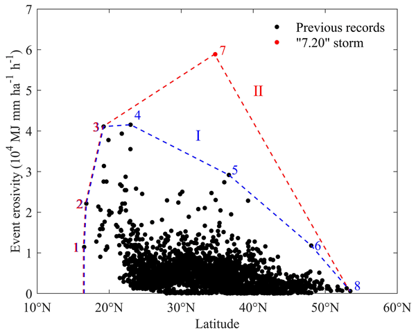
An exceptionally heavy rainfall event occurred on 20 July 2021 in central China (the 7.20 storm). The storm presents a rare opportunity to examine the extreme rainfall erosivity. The storm, with an average recurrence interval of at least 10 000 years, was the largest in terms of its rainfall erosivity on record over the past 70 years in China. The study suggests that extreme erosive events can occur anywhere in eastern China and are not necessarily concentrated in low latitudes.
Tianyu Yue, Shuiqing Yin, Yun Xie, Bofu Yu, and Baoyuan Liu
Earth Syst. Sci. Data, 14, 665–682, https://doi.org/10.5194/essd-14-665-2022, https://doi.org/10.5194/essd-14-665-2022, 2022
Short summary
Short summary
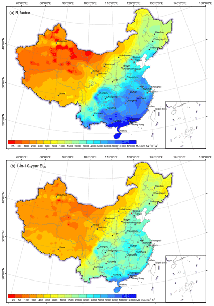
This paper provides new rainfall erosivity maps over mainland China based on hourly data from 2381 stations (available at https://doi.org/10.12275/bnu.clicia.rainfallerosivity.CN.001). The improvement from the previous work was also assessed. The improvement in the R-factor map occurred mainly in the western region, because of an increase in the number of stations and an increased temporal resolution from daily to hourly data.
Yuanyuan Xiao, Shuiqing Yin, Bofu Yu, Conghui Fan, Wenting Wang, and Yun Xie
Hydrol. Earth Syst. Sci., 27, 4563–4577, https://doi.org/10.5194/hess-27-4563-2023, https://doi.org/10.5194/hess-27-4563-2023, 2023
Short summary
Short summary
An exceptionally heavy rainfall event occurred on 20 July 2021 in central China (the 7.20 storm). The storm presents a rare opportunity to examine the extreme rainfall erosivity. The storm, with an average recurrence interval of at least 10 000 years, was the largest in terms of its rainfall erosivity on record over the past 70 years in China. The study suggests that extreme erosive events can occur anywhere in eastern China and are not necessarily concentrated in low latitudes.
Tao Zhang, Yuyu Zhou, Kaiguang Zhao, Zhengyuan Zhu, Gang Chen, Jia Hu, and Li Wang
Earth Syst. Sci. Data, 14, 5637–5649, https://doi.org/10.5194/essd-14-5637-2022, https://doi.org/10.5194/essd-14-5637-2022, 2022
Short summary
Short summary
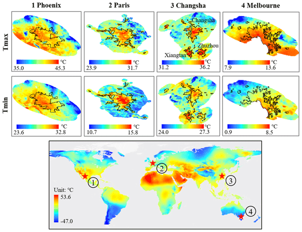
We generated a global 1 km daily maximum and minimum near-surface air temperature (Tmax and Tmin) dataset (2003–2020) using a novel statistical model. The average root mean square errors ranged from 1.20 to 2.44 °C for Tmax and 1.69 to 2.39 °C for Tmin. The gridded global air temperature dataset is of great use in a variety of studies such as the urban heat island phenomenon, hydrological modeling, and epidemic forecasting.
Tianyu Yue, Shuiqing Yin, Yun Xie, Bofu Yu, and Baoyuan Liu
Earth Syst. Sci. Data, 14, 665–682, https://doi.org/10.5194/essd-14-665-2022, https://doi.org/10.5194/essd-14-665-2022, 2022
Short summary
Short summary
This paper provides new rainfall erosivity maps over mainland China based on hourly data from 2381 stations (available at https://doi.org/10.12275/bnu.clicia.rainfallerosivity.CN.001). The improvement from the previous work was also assessed. The improvement in the R-factor map occurred mainly in the western region, because of an increase in the number of stations and an increased temporal resolution from daily to hourly data.
Tao Zhang, Yuyu Zhou, Zhengyuan Zhu, Xiaoma Li, and Ghassem R. Asrar
Earth Syst. Sci. Data, 14, 651–664, https://doi.org/10.5194/essd-14-651-2022, https://doi.org/10.5194/essd-14-651-2022, 2022
Short summary
Short summary
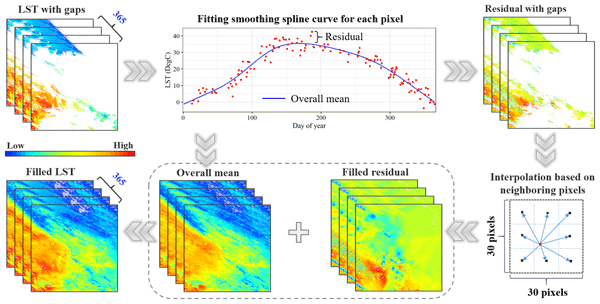
We generated a global seamless 1 km daily (mid-daytime and mid-nighttime) land surface temperature (LST) dataset (2003–2020) using MODIS LST products by proposing a spatiotemporal gap-filling framework. The average root mean squared errors of the gap-filled LST are 1.88°C and 1.33°C, respectively, in mid-daytime and mid-nighttime. The global seamless LST dataset is unique and of great use in studies on urban systems, climate research and modeling, and terrestrial ecosystem studies.
Cited articles
Bahrawi, J. A., Elhag, M., Aldhebiani, A. Y., Galal, H. K., Hegazy, A. K.,
and Alghailani, E.: Soil erosion estimation using remote sensing techniques in
Wadi Yalamlam Basin, Saudi Arabia, Adv. Mater. Sci. Eng., 2016, 9585962, https://doi.org/10.1155/2016/9585962, 2016.
Blanco, H. and Lal, R.: Principles of Soil Conservation and Management, Springer,
New York, 2010.
Bosco, C., de Rigo, D., Dewitte, O., Poesen, J., and Panagos, P.: Modelling soil
erosion at European scale: towards harmonization and reproducibility, Nat.
Hazards Earth Syst. Sci., 15, 225–245, https://doi.org/10.5194/nhess-15-225-2015, 2015.
Breidt, F. J. and Fuller, W. A.: Design of supplemented panel surveys with
application to the National Resources Inventory, J. Agr. Biol. Environ. St., 4, 391–403, 1999.
Brejda, J. J., Mausbach, M. J., Goebel, J. J., Allan, D. L., Dao, T. H., Karlen,
D. L., Moorman, T. B., and Smith J. L.: Estimating surface soil organic carbon
content at a regional scale using the National Resource Inventory, Soil. Sci.
Soc. Am. J., 65, 842–849, 2001.
Cerdan, O., Govers, G., Le Bissonais, Y., Van Oost, K., Poesen, J., Saby, N.,
Gobin, A., Vacca, A., Quinton, J., Auerswald, K., Klik, A., Kwaad, F. J. P. M.,
Raclot, D., Ionita, I., Rejman, J., Rousseva, S., Muxart, T., Roxo, M. J., and
Dostal, T.: Rates and spatial variations of soil erosion in Europe: a study
based on erosion plot data, Geomorphology, 122, 167–177, 2002.
El Haj El Tahir, M., Kääb, A., and Xu, C.-Y.: Identification and mapping
of soil erosion areas in the Blue Nile, Eastern Sudan using multispectral ASTER
and MODIS satellite data and the SRTM elevation model Hydrol. Earth Syst. Sci.,
14, 1167–1178, https://doi.org/10.5194/hess-14-1167-2010, 2010.
Evans, R. and Boardman, J.: The new assessment of soil loss by water erosion in
Europe, Panagos, P. et al., 2015 Environ. Sci. Policy, 54, 438–447 – A response,
Environ. Sci. Policy, 58, 11–15, 2016.
Evans, R., Collins, A. L., Foster, I. D. L., Rickson, R. J., Anthony, S. G.,
Brewer, T., Deeks, L., Newell-Price, J. P., Truckell, I. G., and Zhang, Y.:
Extent, frequency and rate of water erosion of arable land in Britain – benefits
and challenges for modelling, Soil Use Manage., 32, 149–161, 2015.
Fiener, P. and Auerswald, K.: Comment on “The new assessment of soil loss
by water erosion in Europe” by Panagos et al. (Environmental Science & Policy
54 (2015) 438–447), Environ. Sci. Policy, 57, 140–142, 2016.
Foster, G. R.: User's Reference Guide: Revised Universal Soil Loss Equation (RUSLE2),
US Department of Agriculture, Agricultural Research Service, Washington, D.C., 2004.
Fu, S. H., Cao, L. X., Liu, B. Y., Wu, Z. P., and Savabi, M. R.: Effects of
DEM grid size on predicting soil loss from small watersheds in China, Environ.
Earth Sci., 73, 2141–2151, 2015.
Fu, S. H., Wu, Z. P., Liu, B. Y., and Cao, L. X.: Comparison of the effects of
the different methods for computing the slope length factor at a watershed scale,
Int. Soil Water Conserv. Res., 1, 64–71, 2013.
Ganasri, B. P. and Ramesh, H.: Assessment of soil erosion by RUSLE model using
remote sensing and GIS – A case study of Nethravathi Basin, Geosci. Front.,
7, 953–961, 2015.
Gobin, A., Jones, R., Kirkby, M. J., Campling, P., Govers, G., Kosmas, C., and
Gentile, A. R.: Indicators for pan-European assessment and monitoring of soil
erosion by water, Environ. Sci. Policy, 7, 25–38, 2004.
Goebel, J. J.: The National Resources Inventory and its role in U.S. agriculture,
Agricultural Statistics 2000, International Statistical Institute, Voorburg, 1998.
Grimm, M., Jones, R., and Montanarella, L.: Soil erosion risk in Europe,
European Commission, EUR 19939 EN, Joint Research Centre, Ispra, 2002.
Grimm, M., Jones, R., Rusco, E. and Montanarella, L.: Soil Erosion Risk in Italy:
a revised USLE approach, EUR 20677 EN, European Commission, Luxembourg, 2003.
Guillas, S. and Lai, M. J.: Bivariate splines for spatial functional regression
models, J. Nonparametr. Statist., 22, 477–497, 2010.
Guo, Q. K., Hao, Y. F., and Liu, B. Y.: Rates of soil erosion in China: A study
based on runoff plot data, Catena, 24, 68–76, 2015a.
Guo, Q. K., Liu, B. Y., Xie, Y., Liu, Y. N., and Yin, S. Q.: Estimation of USLE
crop and management factor values for crop rotation systems in China, J. Integr.
Agr., 14, 1877–1888, 2015b.
Guo, S. Y. and Li, Z. G.: Development and achievements of soil and water
conservation monitoring in China, Sci. Soil Water Conserv., 7, 19–24, 2009.
He, C. S.: Quantifying drivers of the sediment load reduction in the Yellow
River Basin, National Sci. Rev., 3, 155–156, https://doi.org/10.1093/nsr/nww014, 2016.
Hernandez, M., Nearing, M. A., Stone, J. J., Pierson, E. B., Wei, H., Spaeth,
K. E., Heilman, P., Weltz, M. A., and Goodrich, D. C.: Application of a rangeland
soil erosion model using National Resources Inventory data in southeastern Arizona,
J. Soil Water Conserv., 68, 512–525, 2013.
Herrick, J. E., Lessard, V. C., Spaeth, K. E., Shaver, P. L., Dayton, R. S.,
Pyke, D. A., Jolley, L., and Goebel, J. J.: National ecosystem assessments
supported by scientific and local knowledge, Front. Ecol. Environ., 8, 403–408, 2010.
Kirkby, M. J., Irvine, B. J., Jones, R. J. A., Govers, G., Boer, M., Cerdan,
O., Daroussin, J., Gobin, A., Grimm, M., Le Bissonnais, Y., Kosmas, C., Mantel,
S., Puigdefabregas, J., and van Lynden, G.: The PESERA coarse scale erosion model
for Europe. I. – Model rationale and implementation, Eur. J. Soil Sci., 59, 1293–1306, 2008.
Lai, M. J. and Schumaker, L. L.: Spline functions on triangulations, Cambridge
University Press, Cambridge, 2007.
Lai, M. J. and Wang, L.: Bivariate penalized splines for regression, Statist.
Sin., 23, 1399–1417, 2013.
Lambrechts, C., Wilkie, M. L., Rucevska, I., and Sen, M. (Eds.): Vital Forest
Graphics, United Nations Environment Programme (UNEP), United Nations Food and
Agriculture Organisation (FAO), United Nations Forum on Forests (UNFF),
UNEP/GRID-Arendal, Arendal, Norway, 2009.
Le Bissonnais, Y., Montier, C., Jamagne, M., Daroussin, J., and King, D.:
Mapping erosion risk for cultivated soil in France, Catena, 46, 207–220, 2001.
Le Roux, J. J., Newby, T. S., and Sumner, P. D.: Monitoring soil erosion in
South Africa at a regional scale: review and recommendations, S. Afr. J. Sci.,
207, 329–335, 2007.
Li, Z. G., Fu, S. H., and Liu, B. Y.: Sampling program of water erosion inventory
in the first national water resource survey, Sci. Soil Water Conserv., 10, 77–81, 2012.
Liang, Y., Liu, X. C., Cao, L. X., Zheng, F. L., Zhang, P. C., Shi, M. C., Cao,
Q. Y., and Yuan, J. Q.: K value calculation of soil erodibility of China water
erosion areas and its Macro-distribution, Soil Water Cons. China, 10, 35–40, 2013.
Liu, B. Y., Zhang, K. L., and Xie, Y.: An empirical soil loss equation, in
Proceedings – Process of soil erosion and its environment effect (Vol. II),
12th international soil conservation organization conference, Tsinghua University
Press, Beijing, 21–25, 2002.
Liu, B. Y., Guo, S. Y., Li, Z. G., Xie, Y., Zhang, K. L., and Liu, X. C.: Sample
survey on water erosion in China, Soil Water Conserv. China, 10, 26–34, 2013.
Liu, J. Y., Kuang, W. H., Zhang, Z. X., Xu, X. L., Qin, Y. W., Ning, J., Zhou,
W. C., Zhang, S. W., Li, R. D., Yan, C. Z., Wu, S. X., Shi, X. Z., Jiang, N.,
Yu, D. S., Pan, X. Z., and Chi, W. F.: Spatiotemporal characteristics, patterns
and causes of land use changes in China since the late 1980s, Acta Geogr. Sin.,
69, 3–14, 2014.
Liu, Z.: The national census for soil erosion and dynamic analysis in China,
Int. Soil Water Conserv. Res., 1, 12–18, 2013.
Lu, H., Gallant, J., Prosser, I. P., Moran, C., and Priestley, G.: Prediction
of sheet and rill erosion over the Australian continent, incorporating monthly
soil loss distribution, CSIRO Land and Water Technical Report, CSIRO, Canberra, 2001.
Morgan, R. P. C.: Soil Erosion and Conservation, 2nd Edn., Longman, Essex, 1995.
Mutekanga, F. P., Visser, S. M., Stroosnijder, L.: A tool for rapid assessment
of erosion risk to support decision-making and policy development at the Ngenge
watershed in Uganda, Geoderma, 160, 165–174, 2010.
Nash, J. E. and Sutcliffe, J. V.: River flow forecasting through conceptual models,
Part 1 – a discussion of principles, J. Hydrol., 10, 282–290, 1970.
Nusser, S. M. and Goebel, J. J.: The National Resources Inventory: A long-term
multi-resource monitoring programme, Environ. Ecol. Stat., 4, 181–204, 1997.
Panagos, P., Borrelli, P., Meusburger, K., Alewell, C., Lugato, E., and Montanarella,
L.: Estimating the soil erosion cover-management factor at the European scale,
Land Use Policy, 48, 38–50, 2015a.
Panagos, P., Borrelli, P., Poesen, J., Ballabio, C., Lugato, E., Meusburger, K.,
Montanarella, L., and Alewell, C.: The new assessment of soil loss by water
erosion in Europe, Environ. Sci. Policy, 54, 438–447, 2015b.
Panagos, P., Borrelli, P., Poesen, J., Meusburger, K., Ballabio, C., Lugato,
E., Montanarella, L., and Alewell, C.: Reply to “The new assessment of soil
loss by water erosion in Europe. Panagos P. et al., 2015 Environ. Sci. Policy
54, 438–447 – A response” by Evans and Boardman [Environ. Sci. Policy 58,
11–15], Environ. Sci. Policy, 59, 53–57, 2016a.
Panagos, P., Borrelli, P., Poesen, J., Meusburger, K., Ballabio, C., Lugato,
E., Montanarella, L., and Alewell, C.: Reply to the comment on “The new
assessment of soil loss by water erosion in Europe” by Fiener & Auerswald,
Environ. Sci. Policy, 57, 143–150, 2016b.
Rao, E. M., Xiao, Y., Ouyang, Z. Y., and Yu, X. X.: National assessment of soil
erosion and its spatial patterns in China, Ecosyst. Health Sustain., 1, 1–10,
https://doi.org/10.1890/EHS14-0011.1, 2015.
Renard, K. G., Foster, G. R.,Weesies, G. A., McCool, D. K., and Yoder, D. C.:
Predicting soil erosion by water, in: Agriculture Handbook 703, US Department
of Agriculture, Agricultural Research Service, Washington, D.C., 1997.
Renschler, C. S. and Harbor, J.: Soil erosion assessment tools from point to
regional scales – the role of geomorphologists in land management research and
implementation, Geomorphology, 47, 189–209, 2002.
Singh, G., Babu, R., Narain, P., Bhushan, L. S., and Abrol, I. P.: Soil erosion
rates in India, J. Soil Water Conserv., 47, 97–99, 1992.
Thomas, J., Prasannakumar, V., and Vineetha, P.: Suitability of spaceborne
digital elevation models of different scales in topographic analysis: an
example from Kerala, India, Environ. Earth Sci., 73, 1245–1263, 2015.
USDA: Summary report: 2012 National Resources Inventory, National Resources
Conservation Service, Washington, D.C., and Center for Survey Statistics and
Methodology, Iowa State University, Ames, Iowa, 2015.
Van der Knijff, J. M., Jones, R. J. A., and Montanarella, L.: Soil erosion
risk assessment in Europe, EUR 19044 EN, European Commission, Luxembourg, 2000.
Vrieling, A.: Satellite remote sensing for water erosion assessment: A review,
Catena, 65, 2–18, 2006.
Wang, G. and Fan, Z.: Study of Changes in Runoff and Sediment Load in the Yellow
River (II), Yellow River Water Conservancy Press, Zhengzhou, China, 2002.
Wang, S. Y., Zhu, X. L., Zhang, W. B., Yu, B., Fu, S. H., and Liu, L.: Effect
of different topographic data sources on soil loss estimation for a mountainous
watershed in Northern China, Environ. Earth Sci., 75, 1382, https://doi.org/10.1007/s12665-016-6130-3, 2016.
Wang, X., Zhao, X. L., Zhang, Z. X., Li, L., Zuo, L. J., Wen, Q. K., Liu, F.,
Xu, J. Y., Hu, S. G., and Liu, B.: Assessment of soil erosion change and its
relationships with land use/cover change in China from the end of the 1980s
to 2010, Catena, 137, 256–268, 2016.
Wischmeier, W. H. and Smith, D. D.: Predicting rainfall-erosion losses from
cropland east of the Rocky Mountains, in: Agriculture Handbook 282, US Department
of Agriculture, Agricultural Research Service, Washington, D.C., 1965.
Wischmeier, W. H. and Smith, D. D.: Predicting Rainfall Erosion Losses: A Guide
to Conservation Planning, in: Agriculture Handbook 537, US Department of
Agriculture, Agricultural Research Service, Washington, D.C., 1978.
Xi, Z. D., Sun, H., and Li, X. L.: Characteristics of soil erosion and its
space-time distributive pattern in southern mountains of Shaanxi province,
Bull. Soil Water Conserv., 17, 1–6, 1997.
Xie, Y., Yin, S. Q., Liu, B. Y., Nearing, M., and Zhao, Y.: Models for estimating
daily rainfall erosivity in China, J. Hydrol., 535, 547–558, 2016.
Zheng, F. L. and Wang, B.: Soil Erosion in the Loess Plateau Region of China,
in: Restoration and Development of the Degraded Loess Plateau, China, Ecological
Research Monographs, edited by: Tsunekawa, A., Liu, G., Yamanaka, N., and Du,
S., Springer, Japan, https://doi.org/10.1007/978-4-431-54481-4_6, 2014.


