the Creative Commons Attribution 4.0 License.
the Creative Commons Attribution 4.0 License.
 | 12 Oct 2022
Cooperation under conflict: participatory hydrological modeling for science policy dialogues for the Aculeo Lake
Anahi Ocampo-Melgar
Pilar Barría
Cristián Chadwick
Cesar Rivas
Hydrological modeling tools can support collaborative decision processes by visually displaying hydrological systems connections, uncertainties, as well as conflicting preferences over water management strategies. Nevertheless, many challenges remain in the real application of these technical tools to successfully implement, capture, and communicate with non-experts the complexities of coupled human hydrological systems. A 5-step process shows how a WEAP-based hydrological study aiming to explore the disappearance of a 12 km2 lake in the Aculeo basin in Chile was transformed into a multiple question-driven sociohydrological modeling process to help answer the diversity of questions instigating conflict. Collaboration allowed construction of a surface–groundwater hydrological model that responded to local stakeholders' uncertainties. While testing a subset of socially accepted management strategies under two climate change scenarios, combining the strategies allows recovering up to half the lake water volume. However, the 5-step participatory modeling process also shows how the increasing social–environmental conflicts over the causes and effects of the water scarcity are challenging barriers to overcome with modeling tools. As presented in this article, although flexible approaches and research agendas could better support the exploration of synergies towards collaboration and production of useful and socially acceptable hydrological models, there are still value-driven aspects of water management that need to be explored to better support science policy dialogues.
- Article
(3965 KB) - Full-text XML
- BibTeX
- EndNote


Sound science is necessary to support decision making where population, economics, and climate change have aggravated conflicts over water (Poff et al., 2003, 2016). However, on top of the scientific uncertainties impacting water stationarity (Galloway, 2011; Kiparsky et al., 2012; Milly et al., 2008), societal complexities make water related problems “wicked”, given their competing and mutually exclusive deep human values and aspirations that are not resolved with technical and economic strategies (Nie, 2010). Addressing water problems from technocratic and governance point of views is to disregard the political and transformative power of water (Boelens et al., 2016; Melsen et al., 2018). In this challenge, the hydrological scientific community is aiming at finding ways to better incorporate the social–ecological interconnections (Mauser et al., 2013; McMillan et al., 2016; Salter et al., 2010) and the different types of knowledge that can contribute to a science policy dialogue (Nardi et al., 2021).
In this science policy challenge, there is an academic and practical need for a diversity of approaches and tools to better support transdisciplinary communication and understanding between scientists and non-scientists. These approaches should ideally facilitate transdisciplinary efforts in at least two aspects of the decisions: (i) understand the context, i.e., support communicating, structuring, and displaying complex system information and connections (Arvai, 2003; Rowe and Frewer, 2000; Wilson and Arvai, 2006); and (ii) explore result, i.e., support discussing the role and impact of stakeholders within the decision context (Gorddard et al., 2016), such as understanding the environmental policy link of their choices (Brewer and Stern, 2005).
Despite their usually broad-scale application, rigidity, and engineering purposes, hydrological modeling tools could support in both the challenges of the decision context and decision results mentioned earlier by (1) visually displaying hydrological systems connections, as well as the uncertainties and knowledge gaps in the information, and (2) clarifying and debating the impact of conflicting preferences in the evaluated water management strategies. Both the decision context and decision results are connected, as a legitimate scientific outcome should result from a credible and salient science collaboration process (Clark and Cash, 2001).
However, science policy collaboration processes are neither simple nor straightforward (Hegger et al., 2012; Scott et al., 2012). Non-scientists need to understand complex interactions between the natural, economic, and social processes (Kahan, 2010; Nisbet, 2009; Somerville and Hassol, 2011), and scientists need to incorporate diverse stakeholders adjusting the scientific process and results to different time frames and different needs (Rice et al., 2009). In the case of hydrological modeling, there are best practices recommendations regarding the level of involvement of participants in the design and testing of hydrological models (Voinov and Gaddis, 2008) that prove how process has a key role in the sense of co-authorship over the product and results of this collaboration (Basco-Carrera et al., 2017). Best practices for participatory hydrological modeling include the following: (a) having a clear problem that all recognize and embrace; (b) selecting an appropriate, simple, and flexible modeling tool for the question complexity, funding, and time; (c) engaging different types of local knowledge from a diverse group of participants as early, as frequent, and as long (all stages of the process) as possible; (d) a neutral, transparent (in its uncertainties), and scientifically sound process that recognizes local historical disagreements; and (e) a process that incorporates facilitation and negotiation (Voinov and Gaddis, 2008; Voinov and Bousquet, 2010; Basco-Carrera et al., 2017).
These participatory hydrological modeling recommendations, however, are usually focused on situations in which there is time and disposition for a long engagement between academia and participants. As we experienced in the Aculeo Lake, the context in which these tools are applied can deeply vary, impacting the success of these best practices and frustrating complex science–society efforts. In this article we will explore these participatory modeling best practices recommendations in a case study that was (1) not originally intended as participatory, (2) in a community experiencing conflict over an environmental catastrophe, and (3) while other government-led attempts at finding collaborative solutions were being implemented. The modeling process and results are described and explored to reflect on the achievements and pitfalls of science–society water modeling in difficult contexts. Insights from behind the scenes during the Aculeo Lake modeling process are used to develop guidelines that contribute to participatory modeling and transdisciplinary efforts in contexts of high conflict and poor information on the hydrological system.
The Aculeo Lake desiccation in Chile is an example of where neither science by itself nor public participation alone were enough to properly address the conflicting views of a water related wicked problem. The drying of the Aculeo Lake, a 12 km2 water body, has been an internationally iconic example of the water problems that Chile is facing (Barría et al., 2021). The photographs showing the before/after outcome, as well as of trucks distributing water, have been used in diverse national and international media to discuss climate change and water governance in Chile1. To respond to the water scarcity, and specifically the Aculeo Lake desiccation causes and possible solutions questions, it was necessary to develop a basic surface–groundwater hydrological model. The hydrological modeling study coincided in time with a participatory process called the Voluntary Agreement for Watershed Management (AVGC in Spanish) – a dialogue process usually implemented by the Chilean government in the context of climate change international agreements, but also implemented to find possible agreements between actors with very different interests. Consequently, the traditional hydrological modeling process had to be transformed into a collaborative modeling process in order to confront and include as many opposed views as possible. Exploring this case is important in Chile, as the combination of surface and groundwater hydrological Water Evaluation and Planning System (WEAP) modeling described in this article is being implemented in national watershed management to develop the first set of 101 Strategic Planning at the Watershed Level throughout Chile. Therefore, this study also contributes to show how a WEAP modeling process can also be used for collaboration and mutual learning in water resources management.

Figure 1The Aculeo basin located in central Chile near the capital, Santiago (a, b), and main land uses (c).
The Aculeo Lake basin is a 200 km2 sub-basin of the Maipo River in the metropolitan region, central Chile (Fig. 1), a mainly agricultural zone 50 km south of Santiago (the capital), but also was one of the most iconic touristic hotspots of the metropolitan region. Runoff from several creeks from the upper basin (2000 m a.s.l.) flow into the Aculeo Lake located in the middle of the valley. Around 526 mm of rainfall is the annual average (data from 1960–2016), 94 % of which is received in autumn–winter (April–September) and 6 % is spring–summer rain (October–March). This is a heavily intervened basin like many agricultural basins in central Chile (more on this below). The lake should naturally drain into the Aculeo creek (also called Santa Marta or Santa María) towards the Huiticalan creek, but a small detour infrastructure keeps water from naturally flowing.
Agriculture and livestock have been the main productive activities in the Aculeo valley, since 1660 when this was a private large state (hacienda). During this time, the Aculeo Lake basin also went through a physical transformation from a natural basin to an anthropogenic watershed with a series of channelizations for different productive activities. The first Agrarian Reform in 1962, law no. 15,020, redistributed land among peasants until the military coup of 1973 (Bellisario, 2007; Órdenes and Díaz-Diego, 2018). During the military government, the 1981 Water Code distributed water use shares (WUS) to be transacted in a free market (Bauer, 2004; Madaleno and Gurovich, 2007), given by the General Water Directorate (DGA) to anyone who asks as long as there is availability. The 1981 Water Code had slight adjustments in 2005 with the establishment of water ecological flow restriction for new water rights, a fee in the case of non-use of water rights, and the obligation to report transactions on water rights, but its essence is still primarily market based.
The Aculeo Lake drying process started in 2010, until it went completely dry in 2018. The phenomenon coincided with the megadrought (Garreaud et al., 2017, 2019), a climate event manifested as a sequence of years with 25 % to 45 % precipitation deficit affecting central Chile since 2010 in terms of reduction in streamflows and increasing evapotranspiration processes. Nevertheless, several uncertainties remained with regard to the human management factor in the water scarcity problem, as water wells were also suffering from a decline in their levels. In this regard a hydrological modeling study was commissioned by the Regional Government of Santiago to explore the potential causes of the lake desiccation (Barría et al., 2020). The hydrological study used a surface (WEAP software) and groundwater (MODFLOW software) hydrological model to explore possible solutions to restore the Aculeo Lake or alleviate the water scarcity.
As it should be expected, the lake desiccation exacerbated conflicts among users, including additional indirect conflicts such as livestock wandering and later dying because of the lack of water, creating problems for ecosystems and later major sanitary issues. This ecological and social problem led the Sustainability and Climate Change Agency (ASCC in Spanish), mandated by the Environmental Ministry, to work on an AVGC. The AVGC is a process in which different private and public organizations (including academia) voluntarily work to identify different actions and strategies in which to collaborate to address a basin challenges (e.g., a private company may support a civil organization to find funds for water conservation). Water scarcity was one of those problems in discussion, which also further pushed interaction with the hydrological modeling study. Although the AVGC and the hydrological modeling were designed to be implemented in parallel, given the level of conflict and large number of uncertainties, we saw an opportunity to actively participate in the AVGC process and advance towards a more collaborative hydrological modeling.
This section is organized into two main elements for the hydrological modeling: (1) the model structure construction (Sect. 3.1) and (2) the process of discussion on problems and solutions that structured the model (Sect. 3.2). Although we show both aspects in isolation, both are profoundly interlinked as the process of discussion helped define the model structure and outcomes. As will be presented in Results (Sect. 4), the modeling outcome has its own technical merit; however, the process has some nuances that drive the discussion.
3.1 Model development
The surface–groundwater model used for the hydrological balance analysis was the semi-distributed hydrological modeling software WEAP (Yates et al., 2005a, b). WEAP has been successfully used in participatory processes to study climate change adaption options (Bhave et al., 2014), ecosystem services assessment (Yates et al., 2005a), or the economic impact of water agricultural policies (Varela-Ortega et al., 2011). The aquifer and its connection to the lake and other catchments, is represented by a node that gathers its hydrogeological characteristics, analyzed as part of the hydrological study project (Barría et al., 2021). The development of the WEAP model, water balance, and the attribution study that unraveled the “causes” of the lake desiccation (i.e., between two possible causes, the megadrought and increasing water demands, due to land use and/or land cover changes), concluding that the megadrought was the main cause, are described in detail in two technical reports (Barría et al., 2020; Bluedot, 2020), as well as in a peer-reviewed paper (Barría et al., 2021).
3.2 Participatory process to hydrological modeling of the Aculeo basin
As was explained earlier, a Voluntary Agreement for Watershed Management process was initiated at the same time as the hydrological modeling study2. Authors of this paper were conducting the hydrological study, but at the same time, guest participants of the AVGC discussion were acting as potential academia partners for the resulting agreement. As this study was conducted independently, but simultaneously with the AVGC process, there was a synergy that resulted in increased stakeholder participation in the hydrological modeling, and also, consideration of modeling results in the lake rehabilitation measures discussions.
In the line of the participatory modeling literature and the categories of participation by Basco-Carrera et al. (2017), the Aculeo Lake modeling followed a consultation during the modeling stage and a discussion during the scenario analysis, going back to a co-design to refine the model structure and input used in the modeling stage (Fig. 2). Basco-Carrera et al. (2017) levels of participation for water resources planning and management is partly based on the Ladder of Participation by Sherry Arnstein (1969), a description of eight levels of citizen participation that is linked with power over decisions being made, Bruns (2003) who proposed an extended ladder including terms such as autonomy, advising, and enabling, and Mostert (2003) who takes this ladder into water policy defining levels of citizen influence from information, consultation, discussion, co-designing, co-decision making, and independent decision making.
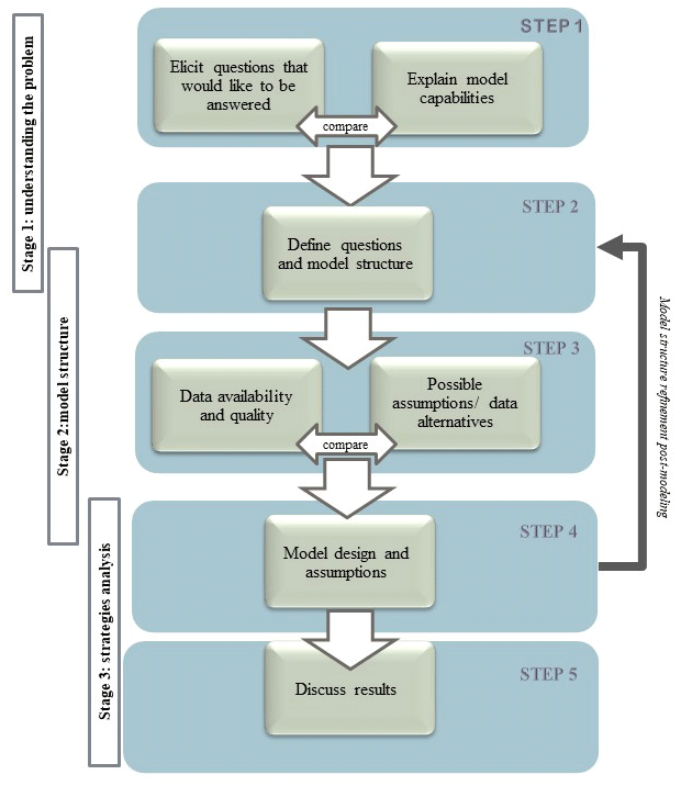
Figure 2Main steps that guided the participatory modeling process. On the left there is a comparison with the questions/comments interaction stages presented in Fig. 3.
Regarding the purpose of the modeling, contrary to Bhave et al. (2014) where the objective was focused on the alternatives, in this project the original effort was to understand the hydrology and the causes of the water scarcity, reasons why the model was built. Modeling water management alternatives was a necessary addition after constructing the model and realizing the existing level of conflict caused by scientific uncertainties that the AVGC was encountering when exploring collaboration towards facing water challenges. As Fig. 2 shows, the hydrological model structure was built inspired by inputs from the stakeholders discussing (i) causes of the water crisis and (ii) management strategies to solve the crisis. Levels of citizen participation varied depending on the modeling stage. In stage 1 stakeholders' consultation was part of our own participation in five meetings of the voluntarily group where key actors previously selected through the governmental effort discussed possible causes for the lake desiccation (information later transformed into model variables). In stage 2, in-depth interviews and photointerpretation with key local stakeholders and local agriculture experts were used to better improve the modeling process (including characteristics of each plot in terms of assets, production, and general reasons for changes). In stage 3, possible strategies and scenario analysis were determined through conducting group semi-directed interviews with ten representatives of governmental and non-governmental organizations (Table 1) for each of the different land uses identified (more information in Ocampo-Melgar et al., 2021).
Table 1Stakeholder groups interviewed in the Aculeo Lake basin.

This approach resulted in an initial hydrological modeling structure for the Aculeo basin (i.e., identification of inflows and outflows), a list of eight water management strategies (e.g., water use by the agricultural sector), as well as four institutional support ideas and management strategies, collected from the AVGC debates, including extreme positions presented by the different stakeholders during those open discussions. A refined list of those 12 strategies mentioned along with a list of other strategies that are being applied in similar basins, were presented to 25 individuals from nine stakeholder groups that were previously selected as key actors by the AVGC process (Table 1) to elicit their interest or concerns about the strategies. During these individual and confidential interviews, stakeholders were requested to comment and suggest changes, as well as to give a 1–3 value to each idea, where 1 was a very bad idea, 2 an acceptable idea, and 3 an excellent idea. Variations and considerations on each ranking were also gathered to make sure the wording of each strategy was understood. All stakeholders had equal voice, and information was not aggregated but only used to better understand the degree of acceptability of each strategy.
A subset of the best ranked “action/strategies”, adjusted based on the interviews, were simulated in the Aculeo basin WEAP model:
-
Agricultural irrigation efficiency. The improvements in agricultural water efficiency is commonly used in Chile to increase irrigation area. The strategy here is to increase water efficiency, but without increasing agricultural area. The interviews allowed to corroborate that industrial agriculture already has high irrigation efficiency, but there still are important amounts of annual crops with water efficiencies of 50 %. Two scenarios were simulated in WEAP: scenario 1 increased the water efficiency of annual crop to 70 %, while scenario 2 increases to 85 %.
-
Rural house grass gardens reduction. An increase in second homeowners during the past decade coincided with the water crisis, generating discomfort and suspicion among traditional inhabitants about their preference for grass gardens, being the cause of the lake disappearance. Eliminating rural house gardens was perceived by the hydrological modeling group (the authors) as a good strategy before the interviews. However, people that used to work in other agricultural activities are currently working as gardeners; hence, eliminating gardens might have quite a big impact. After interviews, simulation used recommendations by Bown and Fuentes (2021), which is 20 % of the gardens with grass, 30 % the shrubs of intermediate consumption, and 50 % of the surface with cacti species, stones, or xerophytic type garden with no irrigation. This scenario incorporates both the need to reduce water consumption and the people's need of not eliminating grass due to the impact it may have on their jobs.
-
Recovery of water use shares. This watershed has a long history of occupation, which has resulted in numerous manmade water structures, and some are not even known by landowners due to their antiquity. Even though diversion was confirmed to be legal, and eliminating it means the expropriation of WUS, an extreme measure in Chile given that water shares are real state asset, the strategy was simulated to respond to stakeholders' concerns. This potential strategy considers the diversion of water not being used in some months by other nearby basins (which would make it feasible without actually expropriating WUS) in two inflow scenarios, one with 700 L s−1 and the other with 1000 L s−1, from March to May. In fact, there is a project currently being studied called “Aguilino Chanal” that may have a similar goal, so we used the name for familiarity with the concept.
Finally, to evaluate the sustainability of the strategies, a business as usual climate change scenario (Representative Concentration Pathway RCP8.5; Van Vuuren et al., 2011) and a moderate scenario (RCP4.5) were also considered in the water balance simulations. To assess the effectiveness of these strategies, a reference scenario without management strategies under climate change was also implemented. We used approximately 100 general climate model (GCM) simulations from ∼30 models, under the RCP4.5 and RCP8.5 scenarios (Van Vuuren et al., 2011), which were bias corrected using the quantile delta mapping method (QDM; Cannon et al., 2015). Model final outcomes were presented in different meetings with local stakeholders and governmental officials to receive and give feedback on future steps that were being considered. The final use of the model, however, encountered other challenges that will be discussed in Sect. 4.5.
The main results from this research are presented in 5-step guidelines that indirectly resulted as the main outcome, which had started as a traditional modeling and slowly transitioned into a more participatory process. Figure 2 describes the 5-step guidelines that address both modeling phases and also science-policy challenges that will be described and could guide future research.
4.1 Step 1: collecting the questions
Understanding the problem helps framing the model, but it is also an opportunity to evaluate the context and the possibility of reducing non-modeling uncertainties with other sources and tools. Therefore, in an initial step, it was important to collect all pressing questions that stakeholders would like to have answered (Fig. 3), while carefully explaining the limitations and capabilities of the hydrological model in terms of representing biophysical processes around a specific problem. In this step, contrasting opinions voiced during the meetings on both, the causes of the water scarcity and the need to rehabilitate the lake, hinted at the level of underlying tension in this community (Ocampo-Melgar et al., 2021) but also pointed at the uncertainties that were essential to be addressed. From all questions and lines of explanation, we identified plausible from impossible questions to answer with the model, and then defined which impossible questions were key to address for the stakeholders to be confident about the hydrological modeling representation of their basin, e.g., discerning which inflows and outflows were legal, despite not being physically necessarily for a basin representation (see step 4.3).
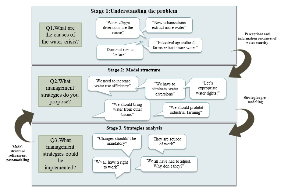
Figure 3Main questions that emanated from the voluntary agreement conversations that fed the modeling process in terms of framing the problem, designing the base structure, and identifying potential strategies.
4.2 Step 2: dividing questions for the conceptual modeling development and for the simulation of strategies
In the second step it was necessary to organize questions in variables for the model, in terms of structure (i.e., where do inflows and outflows come from and go?) and questions that were more related with possible strategies. In the case of questions that were related with the model structure, it was necessary to consider their connections with enough flexibility to be able to modify the conceptual model later, as other inquiries or questions can arise in the process that may change the conceptual view of the basin. This was the case of land uses water demands, as there were many uncertainties with the official information (see step 3). The final land uses classification required several iterations regarding how the variables were being conceived, along with stakeholder involvement and legal information analysis, such as the analysis of records at the real estate conservator to confirm the official land use of each plot (see Barría et al., 2021; Barría et al., 2020, Chap. 4).
A similar iterative approach was followed on the set of questions and comments that were more related with what stakeholders considered were possible solutions. To better turn these comments into strategies, individual interviews and group discussions with stakeholders were used to assess the social acceptability of the strategies, even though some of these “solutions” did not have legal or technical possibility of being implemented, e.g., transfers from a neighbor basin that is already over-allocated. Results of the interviews allowed selection of a subset of strategies that could be tested with the hydrological model, and a group of strategies for which technical, financial, and legal information was gathered to contribute to their analysis (Barría et al., 2020, Chap. 5).
The interviews showed that the most “extreme” solutions may not necessarily have the majority support. In Table 2, a summary of individual rates or evaluations of each strategy show a positive view on some strategies, although they are recognized as not solutions to the water scarcity problem. Other strategies were reworded and changed in the model after the interviews. This was the case of “elimination of grass”, which after the round of interviews it was clear that nobody agreed as it had been described. The strategy was implemented in the model as an alternative garden for semi-arid central Chile, where according to Bown and Fuentes (2021), water consumption can be reduced up to 80 % in the summer months through changes in plant species and their distribution.
Table 2Assessment and general comments on the strategies or lines of actions provided by the interviewees.

Additionally, regarding a low rating in some of the cases (e.g., water reuse), it is important to notice, in this step, the representativeness of the stakeholder group that gave the low rating (e.g., may be an important economic sector), as well as the justifications given for their evaluation, as this information points to aspects that could facilitate their implementation and avoid future conflict. This was the case of strategies that are implemented at a household scale and therefore could require government support to alleviate the economic burden mentioned by citizens. At the same time, results showed that sometimes the most mentioned or publicized strategy in the heat of conflict (e.g., industrial farming prohibition) may be recognized as a not very good option while discussed it in private.
4.3 Step 3: evaluating information availability and quality
Once questions have been determined for the model structure and the simulation of strategies, the next step is to evaluate the availability of official and scientific information. In this case, the main challenges, among many, were the short fluviometric records in the basin (i.e., less than 7 years for only one station), the non-existence of previous detailed groundwater studies, and uncertainties on the number of WUS granted in the basin. The first two of these unknowns had to be addressed for the hydrological modeling to represent the historical hydrology. Given the level of conflict and distrust, to avoid eliminating questions or concerns due to an initially presumed lack of data, it was important to include stakeholders in this step by letting them know the information gaps, as well as the alternative methods and assumptions that had to be adopted to be able to proceed. This step was key for the participants to understand the scientific process behind the model and also for the modelers to find alternative sources of information, e.g., private aquifer information and non-public local governmental records on water use efficiency.
On the third data gap (uncertainty on WUS), although from a water balance perspective water uses, legal or not, need to be considered in the hydrology, this variable was also an important source of conflict (identified in step 1), as there was a perception that a drastic increase in new agricultural uses and homes had caused the water desiccation (Ocampo-Melgar et al., 2021). Therefore, more information was necessary to reduce WUS uncertainties, although not necessarily hydrological uncertainties. Two side analyses had to be conducted to have more clarity on both the legal and the actual water uses. Historical aerial photography and WUS information were analyzed on a specific manmade stream diversion channel up in the basin that, according to some stakeholders, through those diversions people had been stealing water from the watershed. The diversion channel was visited, followed by interviews with the Agriculture and Livestock Service and review of 1956 property documents borrowed from the Real Estate Conservative, confirming the legality of those water shares. Second, a water share study in the Real Estate Conservative was conducted to provide more clarity about how many shares have been granted in the basin (see Chap. 4 in Barría et al., 2020). Results showed that WUS collated by the DGA official database represent only 30 % of the total WUSs granted in the basin, where the remaining 70 % (granted during the agrarian reform) are not considered in current water balance estimations. This means that if all granted WUSs were actually used, the lake would have dried up long before the beginning of the megadrought (most likely during the mid 1980s), and adaptation strategies oriented to restore the lake would be useless.
In this step, although we agree with previous research that stakeholders' involvement improves hydrological model acceptance within the community (Voinov and Gaddis, 2008; Voinov and Bousquet, 2010; Basco-Carrera et al., 2017), as well as helps in opening doors to alternative information that the community may have, we also found that this does not necessarily reduce conflicts, as the information found in this case was not what some stakeholders were expecting. This was, for example, the case of the connection between the lagoon and the aquifer that was found dominated by surface flows, due to the confining layer of clay that separates them, a theory that was not accepted by those who were convinced that the increase in water extractions was the cause of the lake disappearance. A similar reaction was received by those who were convinced that diversions and agricultural uses were illegal because they were not in the official database, but as explained earlier, this is because water distributed during the agrarian reform has not been registered in the official records (Barría et al., 2020).
4.4 Step 4: share model intermediate outcomes and assumptions
Once data have been evaluated and the model is tested, there are intermediate outcomes to share and hypotheses to discuss before the model is considered finished. The AVGC meetings were used to present intermediate results while an opportunity was given for stakeholders to question and challenge the accuracy and validity of the hydrological model being constructed, which in turn forced the modeling team to challenge official information and search for alternative sources and approaches to find answers, such as the official versus the real number of water wells.
In terms of the intermediate outcomes, results of the three strategies that could be modeled by the WEAP tool proved to be an efficient combination of high and moderate socially accepted strategies: (1) the diversion of water not being used for some months by the agriculture users of the Aguilino channel (Aguilino); (2) agricultural irrigation efficiency, increasing the efficiency of annual crops from 50 % to 85 %; and (3) rural house grass gardens reduction, implemented as 20 % of the gardens with grass, 30 % the shrubs of intermediate consumption, and 50 % of the surface with cacti species, stones, or a xerox type garden, with no irrigation.
Figure 4 shows the lake water volume simulated under the historical, and climate change, scenario as a result of the water balance of the basin. According to the simulations, by implementing the three adaptation measures under the historical climate (“Hist. Adapt” in Fig. 4a, b, e, and f), the volume of the lake would have been around 34 millions m3 (56 % of the lake volume) during the megadrought. Note that as presented by Barría et al. (2021), the Aculeo Lake has been completely desiccated since 2018. The simulations under climate change projections reveal that there are significant differences in the simulated water volumes when comparing the “no adaptation” (solid lines in Fig. 4a and b) against the “adaptation” scenarios (dotted lines in Fig. 4a and b). Under both climate change scenarios, the effectiveness of the strategies is evident for the dry 15th percentile, which generate an increase in 28.2 and 20.8 millions m3 of the lake volume compared with the scenarios without the strategies, under the RCP4.5 and the RCP8.5 scenarios, respectively. Moreover, the average of the different GCM simulations (50th percentile) also shows large differences in the lake volume by including, or not, the strategies, with differences that fluctuate between 10.2 and 39.8 millions m3 under the RCP4.5 and the RCP8.5 scenarios, respectively, for the 2050–2100 period. Finally, the simulations for the last 30 years of this century, under the severe climate change scenario, indicate that by implementing the three adaptation measures, half of the time, the lake would maintain 50 millions m3 of volume.
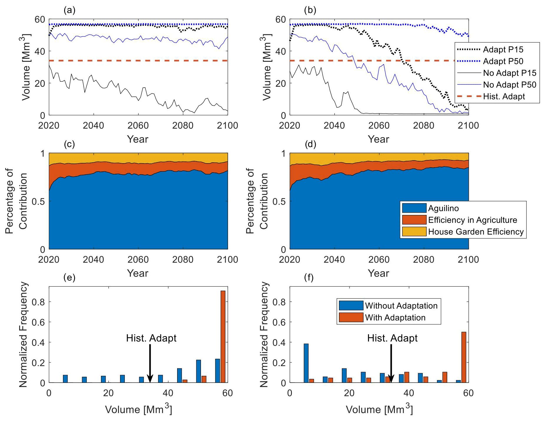
Figure 4WEAP model water balance results under the combination of strategies: (a) annual lake water volume simulated under the RCP4.5 scenario; (b) same as (a) but under RCP8.5 scenario; (c) projected percentage of contribution of each strategy under the RCP4.5 scenario; (d) same as (c) but under RCP8.5 scenario; (e) normalized water volume frequency using different GCM simulations for the period 2071–2100 under the RCP4.5 scenario; (f) same as (e) but under RCP8.5 scenario.
Comparatively, although the three strategies contribute to the water balance, as presented in Fig. 4c and d, the linkage to the agricultural channel adaptation measure has the largest contribution to the lake water volumes under the climate change scenario. Among the three strategies, the contribution of the Aguilino for the 2050–2100 period under the RCP8.5 scenario represents about 83 % of the increase in the water volume, which is around 10 times more than the contribution of the agricultural water use efficiency and the garden water use efficiency. Although the two strategies oriented to improve the irrigation efficiency in the basin have a comparatively lower impact on the water balance at the basin scale, they can be part of a combination of strategies socially accepted by the stakeholders, as proved by the high ranking obtained, which could contribute to increased awareness of the complex water scarcity problem and better preparedness for climate change impacts.
Regardless of the stakeholders' feedback that helped improve the model and the interesting combination of strategies and novel information that was gathered during the process, as we learned from the Aculeo case, the scientific process of progressively adjusting the model and results may be perceived as a lack of certainty by some participants, especially by those that support certain theories that are discarded in the process. On top of this, in step 4 we thought it was important to be unbiased and avoid rising expectations on the identification of “culprits” early in the process when the hydrological balance study was still in progress, as this does not contribute to the necessary dialogue; nor does it represent the complexity of sociohydrological systems, which may show that usually there is a complex combination of factors (Barría et al., 2020) affecting unequally multiple actors for sometimes indirect reasons (Trimble et al., 2021; Ocampo-Melgar et al., 2022) and with very different and valid points of view (Ocampo-Melgar et al., 2021). However, not being vocally strong about placing guilt may be perceived as taking sides, a misguided perception that can impact trust in the process.
4.5 Step 5: communicating and discussing results
Once the model and strategies evaluation were finished, to increase readability, results were published in a book in Spanish (Barría et al., 2020) and presented in different public workshops and portrayed by the media. Presenting final results to the public, however, was one of the most failed aspects of the science–society collaboration. As was experienced in the Aculeo case, modeling results did not leave everybody pleased, as there are underlying conflicts that a scientific answer will not diffuse. As Goleman (1989) has discovered, once an idea is conceived of how the world works, one tends to incorporate information that validates that idea and discard contradictory information; hence, people whose original ideas do not match the results will tend to discard a given study. Therefore, disseminating scientific information in the media, when these results involve conflictive issues, required careful skills that usually are not part of researchers' or academic institutional communication. Understanding the context, conflicts, perceptions, and values involved were important to design the model but also must guide the most sensitive way to inform results (Abels, 2007).
The process and model results were key to support conversations and strategies evaluation during the first year of the collaborative meetings (2018–2021). However, other political changes and economic interests affected the internal dynamics of this collaborative group that had a short span of funding (2 years). At the same time, as the model results did not necessarily validate all opinions and expectations, it was no longer useful for some stakeholders at the AVGC. The hydrological modeling is, however, an important result still being presented and used in decision-making settings. Currently, the Aculeo WEAP model is part of a new project set to estimate the ecosystem services of native forest and to analyze the exacerbated impact of climate change in the water balance due to both, changes in native forest dynamics and the basin hydrological response, a project that will engage with other stakeholders in the Aculeo basin.
The modeling approach implemented in the Aculeo highlighted the importance of the participation in the modeling process, as it allowed for the identification of a combination of strategies that are of moderate impact but of higher local acceptability than the large structural options. On the contrary, a solely top-down hydrological modeling would not have considered less efficient solutions, due to their relatively more moderate impact in terms of the lake inflows. However, stakeholder involvement in the modeling process did not necessarily smooth the discussion, as we explored in the 5-step guidelines that determined the interaction with participants. From this experience, we have the following insights for science–society initiatives involving hydrological modeling with limited information, and when underlying conflicts may demand a more cautious, but still participatory, process to help uncover crucial elements for the success of the modeling process:
-
Conflictive situations require facilitated participation. Although the 5-step guidelines shows a process of communication during modeling, this was possible due to the facilitated setting of the AVGC. Future modeling processes should consider proper neutral facilitation and different instances for one-on-one dialogue and group deliberation. For example, the Aculeo process showed that information (in this case strategy preferences) obtained from individual interviews gave very different results from group conversations when discussions were used to show power over other stakeholders. Including these instances in a more structured way could have reduced the extreme opinions during the group meetings.
-
Accepting manageable uncertainties. In our experience, it is better to discuss uncertainties as early as possible, as assumptions and information gaps will show eventually. Including local decision makers in the process of finding alternative solutions to those gaps may help empower them and make them participants of the modeling. As proposed by many authors before, complex problems where there is a high uncertainty in knowledge, distribution of power, and ambivalent goals are better approached through participatory and deliberate methods to discuss the different possible narratives than a single participatory modeling or top-down policy approaches (Pellizzoni, 2012; Stirling, 2006; Wise et al., 2014). However, there is also a large chance of finding very different and contradicting information that is impossible to contrast, such as when there is a fine legal interpretation in between or where there are no possibilities to confront the reality due to lack of data or time and funds constraints.
-
Compromise between positions is limited. The use of hydrological models for supporting decision making in the Aculeo participatory process showed the acceptance and legitimacy of the model increased once stakeholders noticed their knowledge and opinions were incorporated, which may or may not increase model complexity. When opinions are later confronted with the modeling results, an increased understanding may help bring closer originally opposite opinions, as has been previously shown in deliberate processes that have focused on understanding the problem and learning about different facts and values (Hermans et al., 2007). However, as we found, in some cases, when conflicts have surpassed a dialogue limit, and when many economic and political interests are involved, not even the best available science will make their positions closer. As Weible et al. (2010) discusses, how science is integrated in a discussion will depend on if this is a “collaborative” vs. an “adversarial” policy situation, as either of those contexts will determine if scientists are allies of all, or adversaries of one, of the “coalitions”. Therefore, when conflicts are high, if scientific findings do not support a group of belief systems that explain a position (Goleman, 1989), this automatically sets science on the adversarial side (Weible et al., 2010).
-
No neutral role for the hydrological model. The model development and application should aim at supporting the conversation by showing different scenarios while avoiding choosing a side. Nevertheless, as we found in this experience, maintaining neutrality is extremely difficult in situations of high conflict, especially in these times, as expressed by Pellizoni (2012), when science and technology are charged with growing social expectations but are greeted with equally growing skepticism or hostility. Especially when the decision is over a politically contentious topic with uncertain science, there is the high probability that lack of credibility (“we don't believe this”), legitimacy (“the process has been corrupted”), and/or salience (“science answered the wrong question”) of the results complicate the use of science for policymaking (Cash et al., 2006). As Vogel et al. (2007) stated, “When scientists neglect – even if unintentionally – the political and strategic nature of scientific knowledge, and the political context in which it is produced, they can be faced with uncomfortable and challenging situations for whose navigation many are ill-equipped”. Recognizing the political role of the hydrological model is part of making the process and us, as researchers, better at identifying ways to address science–society interaction and communication when stakes are high, decisions urgent, and uncertainties irreducible (Funtowicz and Ravetz, 1993). Understanding the impact of our results in the community we are researching is just as important as being scientifically unbiased (Babidge, 2016; Budds, 2008).
The participatory modeling implemented in the Aculeo basin was key in navigating this complex situation, understanding and recognizing local actors' opinions, as well as concerns about the model structure, and in the identification of strategies. The participation of this team as members in the discussions of the voluntary agreement group resulted in a diversification of questions and possibilities for the modeling process. Specifically, the participatory identification and evaluation of strategies allowed better adjustment of the hydrological model to answer questions that were causing suspicions and further conflicts among stakeholders. The same process was also important for the identification of a combination of strategies that were of moderate impact but of higher local acceptability than the large structural options. The surface–groundwater hydrological model tested a subset of socially accepted management strategies under two climate change scenarios. It showed that combining more low impact, but socially acceptable, adaptation measures, such as using the out-of-season irrigation surplus (March–May), improving irrigation efficiency for the agriculture industry, and decreasing the grass surface in new urbanizations, would allow to recover up to half the Lake water volume even under a pessimistic climate change scenario. Possibly, a solely top-down hydrological modeling would not have considered less efficient solutions, due to their moderate impact in recovering the Lake.
However, as the experience was not completely successful in terms of engagement, this article also shows that hydrological modeling requires now, more than ever, funding transdisciplinary approaches both in its construction and application, as it is key to achieving credible, salient, and legitimate processes for decision making. As exposed in the Aculeo basin, especially when contentious water related conflicts are high and attribution of climate change impacts are uncertain, collaboration in the hydrological modeling process and appropriate attribution analysis are key in finding management options that could contribute to both, answering the problem and understanding the conflict. This, however, may not necessarily be enough to reduce conflicting positions that are constantly stirred according to personal interests.
Codes are not publicly available, but are available upon reasonable request.
Official data that were used in this study are publicly available from the Dirección General de Aguas website (https://dga.mop.gob.cl/Paginas/default.aspx; DGA, 2022).
AOM, PB, and CC designed the study, interviewed local stakeholders, and participated in the voluntary agreement. AOM elaborated preliminary analysis of the interviews and the participatory experience. CR gathered information for an economic and legal analysis of the strategies. PB and CC developed the hydrological model and simulated the strategies. AOM, PB, CC, and CR discussed the results, and AOM, PB, and CC prepared the manuscript.
The contact author has declared that none of the authors has any competing interests.
Publisher's note: Copernicus Publications remains neutral with regard to jurisdictional claims in published maps and institutional affiliations.
This article is part of the special issue “Contributions of transdisciplinary approaches to hydrology and water resources management”. It is a result of the EGU General Assembly 2020, 3–8 May 2020.
We thank the Regional Government of Santiago. We extend special acknowledgment to Bluedot Consulting for the hydrogeological study that complemented the WEAP model. We also give special thanks to all the community and public services that engaged in the Acuerdo Voluntario de Gestión de Cuencas (Voluntarly Basin Management Agreement) process, and to the reviewers of this article for their valuable insights.
Financial support was provided by the Regional Government of Santiago, project FIC-RM 2017, Code BIP 40002646-0, and FONDECYT Initiation (grant no. 11200027).
This paper was edited by Thomas Thaler and reviewed by Leon Hermans, Brian Cook, and two anonymous referees.
Abels, G.: Citizen Involvement in Public Policy-making: Does it Improve Democratic Legitimacy and Accountability? The Case of pTA, Interdisciplin. Inf. Sci., 13, 103–116, https://doi.org/10.4036/iis.2007.103, 2007.
Arnstein, S. R.: A Ladder Of Citizen Participation, J. Am. Inst. Plan., 35, 216–224, 1969.
Arvai, J.: Using risk communication to disclose the outcome of a participatory decision-making process: Effects on the perceived acceptibility of risk-policy decisions, Risk Anal., 23, 281–289, 2003.
Babidge, S.: Contested value and an ethics of resources: Water, mining and indigenous people in the Atacama Desert, Chile, Aust. J. Anthropol., 27, 84–103, https://doi.org/10.1111/taja.12139, 2016.
Barría, P., Chadwick, C., Ocampo-Melgar, A., Diaz, R., Galleguillos, M., and Poblete, D.: Estudio de balance hídrico en la cuenca laguna de Aculeo, Proyecto FIC-R 2017 código BIP 40002646-0, Caracterización del consumo hídrico y del sistema hidrogeológico en la cuenca de Aculeo, determinación de posibles soluciones y campaña de educación Ambiental, Report for the Regional Government, ISBN 978-956-402-790-6, 2020.
Barría, P., Chadwick, C., Ocampo-Melgar, A., Galleguillos, M., Garreaud, R., Díaz-Vasconcellos, R., Poblete, D., Rubio-Álvarez, E., and Poblete-Caballero, D.: Water management or megadrought: what caused the Chilean Aculeo Lake drying?, Reg. Environ. Change, 21, 19, https://doi.org/10.1007/s10113-021-01750-w, 2021.
Basco-Carrera, L., Warren, A., van Beek, E., Jonoski, A., and Giardino, A.: Collaborative modelling or participatory modelling? A framework for water resources management, Environ. Model. Softw., 91, 95–110, https://doi.org/10.1016/j.envsoft.2017.01.014, 2017.
Bauer, C. J.: Siren song: Chilean water law as a model for international reform, Resources For the Future Press Book, Washington, DC, ISBN 9781891853791, 2004.
Bellisario, A.: The Chilean agrarian transformation: Agrarian reform and capitalist “partial” counter-agrarian reform, 1964–1980. Part 1: Reformism, socialism and free-market neoliberalism, J. Agrar. Change, 7, 1–34, https://doi.org/10.1111/j.1471-0366.2007.00138.x, 2007.
Bhave, A. G., Mishra, A., and Raghuwanshi, N. S.: A combined bottom-up and top-down approach for assessment of climate change adaptation options, J. Hydrol., 518, 150–161, https://doi.org/10.1016/j.jhydrol.2013.08.039, 2014.
Bluedot: Asesoría Hidrogeológica para la Consolidación de un Modelo Hidrogeológico de la Cuenca de Aculeo, Elaborado para la Facultade de Ciencias Forestales y de la Conservación de la Naturaleza, Universidad de Chile, Santiago, 2020.
Boelens, R., Hoogesteger, J., Swyngedouw, E., Vos, J., and Wester, P.: Hydrosocial territories: a political ecology perspective, Water Int., 41, 1–14, https://doi.org/10.1080/02508060.2016.1134898, 2016.
Bown, H. E. and Fuentes, J. P.: Hacia la reducción del consumo de agua en áreas verdes urbanas en la Región Metropolitana, Santiago, Chile, p. 99, ISBN 978-956-404-628-0, 2021.
Brewer, G. D. G. and Stern, P. C.: Decision making for the environment: Social and behavioral science research priorities, Making, Environmental Decision Dimensions, Human Change, Global Isbn, Council Pdf, This Press, National Academies Academy, http://books.google.com/books?hl=en&lr=&id=JeYKuQl3mCUC&oi=fnd&pg=PA1&dq=Decision+making+for+the+environment:+Social+and+behavioral+science+research+priorities&ots=52In3d5qB4&sig=aONXSgXFOtnyqwdEXeGdWDC_ml0 (last access: 9 December 2012), 2005.
Bruns, B. R.: Water Tenure Reform: Developing an Extended Ladder of Participation, Politics of the Commons: Articulating Development and Strengthening Local Practice, in: RCSD Conference, 11–14 July 2003, Chiang Mai, Thailand, 2003.
Budds, J.: Whose Scarcity? The Hydrosocial Cycle and the Changing Waterscape of La Ligua River Basin, Chile, in: chap. 4, Contentious Geographies Environmental Knowledge, Meaning, Scale, edited by: Goodman, M. K., Boykoff, M. T., and Evered, K. T., Routledge, 59–78, ISBN 9781138275591, 2008.
Cannon, A. J., Sobie, S. R., and Murdock, T. Q.: Bias correction of GCM precipitation by quantile mapping: how well do methods preserve changes in quantiles and extremes?, J. Climate, 28, 6938–6959, 2015.
Cash, D. W., Borck, J. C., and Patt, A. G.: Countering the Loading-Dock Approach to Linking Science and Decision Making: Comparative Analysis of El Nino/Southern Oscillation (ENSO) Forecasting Systems, Sci. Technol. Human Values, 31, 465–494, https://doi.org/10.1177/0162243906287547, 2006.
Clark, W. C. and Cash, D.: From Science to Policy: Assessing the Assessment Process, KSG Faculty Research Working Papers Series RWP01-045, Harvard University, John F. Kennedy School of Government, November 2001.
DGA: Catálogo público, Dirección General de Aguas, Ministerio de Obras Públicas, https://dga.mop.gob.cl/Paginas/default.aspx (last access: 10 October 2022.
Funtowicz, S. and Ravetz, J.: Science for the post-normal age, Futures, 25, 739–755, https://doi.org/10.1016/0016-3287(93)90022-L, 1993.
Galloway, G. E.: If Stationarity is Dead, What Do We Do Now?, J. Am. Water Resour. Assoc., 47, 563–570, https://doi.org/10.1111/j.1752-1688.2011.00550.x, 2011.
Garreaud, R. D., Alvarez-Garreton, C., Barichivich, J., Pablo Boisier, J., Christie, D., Galleguillos, M., LeQuesne, C., McPhee, J., and Zambrano-Bigiarini, M.: The 2010–2015 megadrought in central Chile: Impacts on regional hydroclimate and vegetation, Hydrol. Earth Syst. Sci., 21, 6307–6327, https://doi.org/10.5194/hess-21-6307-2017, 2017.
Garreaud, R. D., Boisier, J. P., Rondanelli, R., Montecinos, A., Sepúlveda, H. H., and Veloso-Aguila, D.: The Central Chile Mega Drought (2010–2018): A climate dynamics perspective, Int. J. Climatol., 2019, 1–19, https://doi.org/10.1002/joc.6219, 2019.
Goleman, D. J.: What is negative about positive illusions? When benefits for the individual harm the collective, J. Soc. Clin. Psychol., 8, 190–197, https://doi.org/10.1521/jscp.1989.8.2.190, 1989.
Gorddard, R., Colloff, M. J., Wise, R. M., Ware, D., and Dunlop, M.: Values, rules and knowledge: Adaptation as change in the decision context, Environ. Sci. Policy, 57, 60–69, https://doi.org/10.1016/j.envsci.2015.12.004, 2016.
Hegger, D., Lamers, M., Van Zeijl-Rozema, A., and Dieperink, C.: Conceptualising joint knowledge production in regional climate change adaptation projects: Success conditions and levers for action, Environ. Sci. Policy, 18, 52–65, https://doi.org/10.1016/j.envsci.2012.01.002, 2012.
Hermans, C., Erickson, J., Noordewier, T., Sheldon, A., and Kline, M.: Collaborative environmental planning in river management: an application of multicriteria decision analysis in the White River Watershed in Vermont, J. Environ. Manage., 84, 534–46, https://doi.org/10.1016/j.jenvman.2006.07.013, 2007.
Kahan, D.: Fixing the communications failure, Nature, 463, 296–297, https://doi.org/10.1038/463(21296a, 2010.
Kiparsky, M., Milman, A., and Vicuña, S.: Climate and Water: Knowledge of Impacts to Action on Adaptation, Annu. Rev. Environ. Resour., 37, 163–194, https://doi.org/10.1146/annurev-environ-050311-093931, 2012.
Madaleno, I. M. and Gurovich, A.: Conflicting water usages in Northern Chile, Bol. La Asoc. Geogr. Esp., 45, 439–443, 2007.
Mauser, W., Klepper, G., Rice, M., Schmalzbauer, B. S., Hackmann, H., Leemans, R., and Moore, H.: Transdisciplinary global change research: The co-creation of knowledge for sustainability, Curr. Opin. Environ. Sustain., 5, 420–431, https://doi.org/10.1016/j.cosust.2013.07.001, 2013.
McMillan, H., Montanari, A., Cudennec, C., Savenije, H., Kreibich, H., Krueger, T., Liu, J., Mejia, A., Van Loon, A., Aksoy, H., Di Baldassarre, G., Huang, Y., Mazvimavi, D., Rogger, M., Sivakumar, B., Bibikova, T., Castellarin, A., Chen, Y., Finger, D., Gelfan, A., Hannah, D. M., Hoekstra, A. Y., Li, H., Maskey, S., Mathevet, T., Mijic, A., Acuña, A. P., Polo, M. J., Rosales, V., Smith, P., Viglione, A., Srinivasan, V., Toth, E., van Nooyen, R., and Xia, J.: Panta Rhei 2013–2015: Global perspectives on hydrology, society and change, Hydrolog. Sci. J., 61, 1174–1191, https://doi.org/10.1080/02626667.2016.1159308, 2016.
Melsen, L. A., Vos, J., and Boelens, R.: What is the role of the model in socio-hydrology? Discussion of “Prediction in a socio-hydrological world”, Hydrolog. Sci. J., 63, 1435–1443, https://doi.org/10.1080/02626667.2018.1499025, 2018.
Milly, P. C. D., Betancourt, J., Falkenmark, M., Hirsch, R. M., Zbigniew, W., Lettenmaier, D. P., and Stouffer, R. J.: Stationarity Is Dead: Whither Water Management?, Science, 319, 573–574, 2008.
Mostert, E.: The challenge of public participation, Water Policy, 5, 179–197, https://doi.org/10.2166/wp.2003.0011, 2003.
Nardi, F., Cudennec, C., Abrate, T., Allouch, C., Annis, A., Assumpção, T., Aubert, A. H., Bérod, D., Braccini, A. M., Buytaert, W., Dasgupta, A., Hannah, D. M., Mazzoleni, M., Polo, M. J., Sæbø, Ø., Seibert, J., Tauro, F., Teichert, F., Teutonico, R., Uhlenbrook, S., Wahrmann Vargas, C., and Grimaldi, S.: Citizens AND HYdrology (CANDHY): conceptualizing a transdisciplinary framework for citizen science addressing hydrological challenges, Hydrolog. Sci. J., https://doi.org/10.1080/02626667.2020.1849707, in press, 2021.
Nie, M.: Drivers of Natural Resource-Based Political Conflict, Policy Sci., 36, 307–341, 2010.
Nisbet, M. C.: Communicating Climate Change: Why Frames Matter for Public Engagement, Environ. Sci. Policy Sustain. Dev., 51, 12–23, https://doi.org/10.3200/ENVT.51.2.12-23, 2009.
Ocampo-Melgar, A., Barria, P., Chadwick, C., and Villoch, P.: Restoration perceptions and collaboration challenges under severe water scarcity: the Aculeo Lake process, Restor. Ecol., 29, 1–12, https://doi.org/10.1111/rec.13337, 2021.
Ocampo-Melgar, A., Barria, P., Chadwick, C., and Diaz-Vasconcellos, R.: Rural transformation and differential vulnerability: Exploring adaptation strategies to water scarcity in the Aculeo Lake basin (Chile), Front. Environ. Sci., 10, 955023, https://doi.org/10.3389/fenvs.2022.955023, 2022.
Órdenes, M. and Díaz-Diego, J.: Cuando la mano de obra se subleva: estrategias terratenientes durante la reforma agraria chilena (1964–1973), Hist. Agrar. Rev. Agric. Hist. Rural, 74, 201–230, https://doi.org/10.26882/histagrar.074e07o, 2018.
Pellizzoni, L.: Uncertainty and Participatory Democracy, Environ. Values, 12, 195–224, 2012.
Poff, N. L., Allan, J. D., Palmer, M. A., Hart, D. D., Richter, B. D., Arthington, A. H., Rogers, K. H., Meyer, J. L., and Stanford, J. A.: River flows and water wars: emerging science for environmental decision making, Front. Ecol. Environ., 4, 298–306, 2003.
Poff, N. L., Brown, C. M., Grantham, T. E., Matthews, J. H., Palmer, M. A., Spence, C. M., Wilby, R. L., Haasnoot, M., Mendoza, G. F., Dominique, K. C., and Baeza, A.: Sustainable water management under future uncertainty with eco-engineering decision scaling, Nat. Clim. Change, 6, 25–34, https://doi.org/10.1038/nclimate2765, 2016.
Rice, J. L., Woodhouse, C. A., and Lukas, J. J.: Science and Decision Making: Water Management and Tree-Ring Data in the Western United States, J. Am. Water Resour. Assoc., 45, 1248–1259, https://doi.org/10.1111/j.1752-1688.2009.00358.x, 2009.
Rowe, G. and Frewer, L. J.: Public Participation Methods: A Framework for Evaluation, Sci. Technol. Human Values, 25, 3–29, https://doi.org/10.1177/016224390002500101, 2000.
Salter, J., Robinson, J., and Wiek, A.: Participatory methods of integrated assessment – A review, Wiley Interdisciplin. Rev. Clim. Change, 1, 697–717, https://doi.org/10.1002/wcc.73, 2010.
Scott, C. A., Varady, R. G., Meza, F., Montaña, E., de Raga, G. B., Luckman, B., and Martius, C.: Science-Policy Dialogues for Water Security: Addressing Vulnerability and Adaptation to Global Change in the Arid Americas, Environ. Sci. Policy Sustain. Dev., 54, 30–42, https://doi.org/10.1080/00139157.2012.673454, 2012.
Somerville, R. C. and Hassol, S. J.: Communicating the science of climate change, Phys. Today, 64, 48, https://doi.org/10.1063/PT.3.1296, 2011.
Stirling, A.: Analysis, participation and power: justification and closure in participatory multi-criteria analysis, Land Use Policy, 23, 95–107, https://doi.org/10.1016/j.landusepol.2004.08.010, 2006.
Trimble, M., Jacobi, P. R., Olivier, T., Pascual, M. A., Zurbriggen, C., Garrido, L., and Mazzeo, N.: Reconfiguring water governance for resilient social-ecological systems in South America, in: Water resilience: management and governance in times of change, edited by: Baird, J. and Plummer, R., Springer International Publishing, Cham, Switzerland, 113–135, ISBN 978-3-030-48110-0, 2021.
Van Vuuren, D. P., Edmonds, J., Kainuma, M., Riahi, K., Thomson, A., Hibbard, K., Hurtt, G. C., Kram, T., Krey, V., Lamarque, J. F., Masui, T., Meinshausen, M., Nakicenovic, N., Smith, S. J., and Rose, S. K.: The representative concentration pathways: an overview, Climatic Change, 109, 5–31, 2011.
Varela-Ortega, C., Blanco-Gutierrez, I., Swartz, C., and Downing, T.: Balancing groundwater conservation and rural livelihoods under water and climate uncertainties: An integrated hydro-economic modeling framework, Global Environ. Change, 21, 604–619, 2011.
Vogel, C., Moser, S., Kasperson, R., and Dabelgo, G.: Linking vulnerability, adaptation, and resilience science to practice: Pathways, players, and partnerships, Global Environ. Change, 17, 349–363, 2007.
Voinov, A. and Bousquet, F.: Modelling with stakeholders, Environ. Model. Softw., 25, 1268–1281, https://doi.org/10.1016/j.envsoft.2010.03.007, 2010.
Voinov, A. and Gaddis, E. J. B.: Lessons for successful participatory watershed modeling: A perspective from modeling practitioners, Ecol. Model., 216, 197–207, https://doi.org/10.1016/j.ecolmodel.2008.03.010, 2008.
Weible, C. M., Pattison, A., and Sabatier, P. A.: Harnessing expert-based information for learning and the sustainable management of complex socio-ecological systems, Environ. Sci. Policy, 13, 522–534, https://doi.org/10.1016/j.envsci.2010.05.005, 2010.
Wilson, R. S. and Arvai, J. L.: Policy Analysis Evaluating the Quality of Structured Environmental Management Decisions, Environ. Sci. Technol., 40, 4831–4837, 2006.
Wise, R. M., Fazey, I., Stafford Smith, M., Park, S. E., Eakin, H. C., Archer Van Garderen, E. R. M., and Campbell, B.: Reconceptualising adaptation to climate change as part of pathways of change and response, Global Environ. Change, 28, 325–336, https://doi.org/10.1016/j.gloenvcha.2013.12.002, 2014.
Yates, D., Iwra, M., and Institute-boston, S. E.: Planning Model Part 2: Aiding Freshwater Ecosystem Service Evaluation, Water Int., 30, 501–512, 2005a.
Yates, D., Iwra, M., and Institute-boston, S. E.: WEAP21 – A Demand-, Priority-, and Preference-Driven Water Planning Model Part 1: Model Characteristics, Water Int., 30, 487–500, 2005b.
AFP. Drought wipes popular Chilean lake from the map. Available at: https://www.youtube.com/watch?v=ylnrj_cSB5Y (last access: 10 September 2022); Al Jazeera. Chile suffers the worst drought in 60 years. Available at: https://www.youtube.com/watch?v=qO_YMvUfW-g (last access: 10 September 2022).
FIC-R 2017 BIP 40002646-0 “Caracterización del consumo hídrico y del sistema hidrogeológico en la cuenca de Aculeo, determinación de posibles soluciones y campaña de educación ambiental”.