
Articles | Volume 21, issue 6
https://doi.org/10.5194/hess-21-3145-2017
© Author(s) 2017. This work is distributed under
the Creative Commons Attribution 3.0 License.
the Creative Commons Attribution 3.0 License.
https://doi.org/10.5194/hess-21-3145-2017
© Author(s) 2017. This work is distributed under
the Creative Commons Attribution 3.0 License.
the Creative Commons Attribution 3.0 License.
Research article
| 
29 Jun 2017
Research article |
| 29 Jun 2017
Modeling the water budget of the Upper Blue Nile basin using the JGrass-NewAge model system and satellite data
Department of Civil, Environmental and Mechanical Engineering, University of Trento, Trento, Italy
Department of Geography and Environmental Studies, Mekelle University, Mekelle, Ethiopia
Giuseppe Formetta
Centre for Ecology & Hydrology, Crowmarsh Gifford, Wallingford, UK
Luca Brocca
Research Institute for Geo-Hydrological Protection, National Research Council, Perugia, Italy
Riccardo Rigon
CORRESPONDING AUTHOR
Department of Civil, Environmental and Mechanical Engineering, University of Trento, Trento, Italy
Related authors
No articles found.
Esmaeel Adrah, Luca Brocca, Emine Senkardesler, and He Yin
Earth Syst. Sci. Data Discuss., https://doi.org/10.5194/essd-2026-603, https://doi.org/10.5194/essd-2026-603, 2026
Preprint under review for ESSD
Short summary
Short summary
The eastern Mediterranean is a hotspot for drought, extreme water scarcity, and geopolitical tension, yet long-term data on irrigation is missing. To address this, we used twenty-six years of satellite imagery to track soil moisture and map winter and summer irrigated lands. This freely available data reveals irrigation changes across the region over time, and support managing scarce water resources, understanding climate impacts, and improving regional food security.
Hossein Salehi, Daniele Andreis, Sohaib Baig, Gaia Roati, Marco Brian, Francesco Tornatore, Giuseppe Formetta, and Riccardo Rigon
Earth Syst. Sci. Data Discuss., https://doi.org/10.5194/essd-2026-467, https://doi.org/10.5194/essd-2026-467, 2026
Preprint under review for ESSD
Short summary
Short summary
Here we describe the interpolation procedures followed to build a 1-km gridded daily precipitation and temperature dataset for the Po River District for the 1991–2020 period, with the aim of overcoming the scarcity of high-resolution data, essential for hydrological modelling. Initial data are collected from multi-source observational stations, while topographic data derive from the European Digital Elevation Model. Interpolation performance metrics analysis shows the coherence of this dataset.
Julia Pfeffer, Benoît Meyssignac, Rory Bingham, Alejandro Blazquez, Marie Bouih, Carla Braitenberg, Luca Brocca, Henryk Dobslaw, Ramiro Ferrari, Ehsan Forootan, Helena Gerdener, Muhammad Tahir Javed, Laura Jensen, Volker Klemann, Anna Kremer, Jürgen Kusche, Gilles Larnicol, Muhammad Usman Liaqat, Francesco Leopardi, Elisavet-Maria Mamagiannou, Gerardo Maurizio, Roland Pail, Isabelle Panet, Thomas Papanikolaou, Peyman Saemian, Ingo Sasgen, Maike Schumacher, Marius Schlaak, Linus Shihora, Alireza Sobouti, Nico Sneeuw, Mohammad Javad Tourian, Dimitrios Tsoulis, Georgios Vergos, Bert Wouters, Fan Yang, and Ilias Daras
EGUsphere, https://doi.org/10.5194/egusphere-2026-4642, https://doi.org/10.5194/egusphere-2026-4642, 2026
This preprint is open for discussion and under review for Earth Observation (EO).
Short summary
Short summary
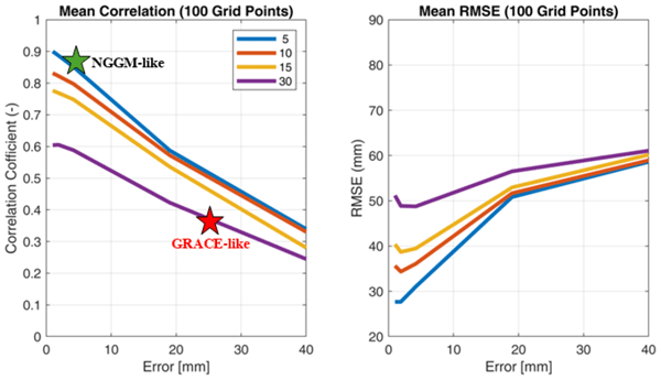
The ESA SING project demonstrates how the future satellite gravity missions NGGM and MAGIC will improve observations of continental water storage, oceans, glaciers, sea level, earthquakes, and climate change. Their more accurate, higher-resolution gravity measurements will enhance Earth system monitoring, improve climate and hazard assessments, and strengthen operational services for water management, disaster preparedness, and environmental decision-making.
Muhammad Usman Liaqat, Stefania Camici, Francesco Leopardi, Jaime Gaona, and Luca Brocca
Hydrol. Earth Syst. Sci., 30, 4969–4983, https://doi.org/10.5194/hess-30-4969-2026, https://doi.org/10.5194/hess-30-4969-2026, 2026
Short summary
Short summary
Tracking land water storage helps examine extreme events and manage water resources. GRACE (Gravity Recovery and Climate Experiment) missions observe changes, but coarse resolution in space and time challenges effective management. New gravity mission called MAGIC (Mass Change And Geosciences International Constellation) can offers better accuracy. This study tested MAGIC’s potential to estimate precipitation using the SM2RAIN approach. Results show SM2RAIN works well with frequent, accurate data but deteriorates with noisy/sparse data, emphasizing the need for precise gravity missions.
Concetta D'Amato, Paolo Benettin, Andrea Rinaldo, and Riccardo Rigon
EGUsphere, https://doi.org/10.5194/egusphere-2026-2385, https://doi.org/10.5194/egusphere-2026-2385, 2026
This preprint is open for discussion and under review for Geoscientific Model Development (GMD).
Short summary
Short summary
Here we validate GEOSPACE, a flexible open-source tool for simulating water exchange between soil, plants, and the atmosphere. Using data from a lysimeter experiment with four vegetation covers, we show that GEOSPACE accurately reproduces soil water dynamics, evapotranspiration, and root water uptake. Its modular design allows selecting among alternative process formulations, making it a reliable tool for ecohydrological research.
Pierre Laluet, Jacopo Dari, Louise Busschaert, Zdenko Heyvaert, Gabrielle De Lannoy, Pia Langhans, Sara Modanesi, Christian Massari, Luca Brocca, Carla Saltalippi, Renato Morbidelli, Clément Albergel, and Wouter Dorigo
Earth Syst. Sci. Data, 18, 4833–4853, https://doi.org/10.5194/essd-18-4833-2026, https://doi.org/10.5194/essd-18-4833-2026, 2026
Short summary
Short summary
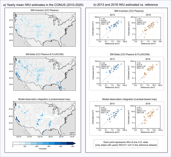
We developed a long-term dataset collection of irrigation water use based on about two decades of satellite observations, three distinct approaches, and many input datasets. The collection provides monthly estimates for major agricultural regions and helps describe how irrigation varies across locations, seasons, and years. It offers a foundation for improving how irrigation is quantified, compared across methods, and integrated into large-scale hydrological and climate studies.
Francesco Avanzi, Hans Lievens, Michael Matiu, Paolo Filippucci, Oscar M. Baez Villanueva, Simone Gabellani, Fabio Delogu, Lorenzo Alfieri, Andrea Libertino, Pere Quintana-Seguì, Diego G. Miralles, Luca Brocca, Christian Massari, and Gabriëlle J. M. De Lannoy
EGUsphere, https://doi.org/10.5194/egusphere-2026-2851, https://doi.org/10.5194/egusphere-2026-2851, 2026
Short summary
Short summary
We developed a new system to map and monitor snow and stored water across large mountain regions using satellite data and computer simulations. Tested in four major European river basins, the system reproduced snow conditions with high accuracy and realistically captured how snow changes with elevation. Because it does not rely on ground measurements, it can help provide consistent information on snow-water resources worldwide, supporting water management and climate adaptation.
Ather Abbas, Yuan Yang, Ming Pan, Yves Tramblay, Chaopeng Shen, Haoyu Ji, Solomon H. Gebrechorkos, Florian Pappenberger, JongCheol Pyo, Dapeng Feng, George Huffman, Phu Nguyen, Christian Massari, Luca Brocca, Jackson Tan, and Hylke E. Beck
Hydrol. Earth Syst. Sci., 30, 3399–3423, https://doi.org/10.5194/hess-30-3399-2026, https://doi.org/10.5194/hess-30-3399-2026, 2026
Short summary
Short summary
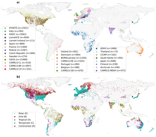
Our study evaluated 24 precipitation datasets using a hydrological model at global scale to assess their suitability and accuracy. We found that MSWEP (Multi-Source Weighted-Ensemble Precipitation) V2.8 excels due to its ability to integrate data from multiple sources, while others, such as IMERG (Integrated Multi-satellitE Retrievals for Global Precipitation Mission) and GDAS (Global Data Assimilation System), demonstrated strong regional performances. This research assists in selecting the appropriate dataset for applications in water resource management, hazard assessment, agriculture, and environmental monitoring.
Peyman Afrasiabikia, Atefeh Parvaresh Rizi, and Luca Brocca
ISPRS Ann. Photogramm. Remote Sens. Spatial Inf. Sci., X-4-W8-2025, 33–38, https://doi.org/10.5194/isprs-annals-X-4-W8-2025-33-2026, https://doi.org/10.5194/isprs-annals-X-4-W8-2025-33-2026, 2026
Ehsan Modiri, Oldrich Rakovec, Pallav Kumar Shrestha, Almudena García-García, Leandro Avila, Katie Blackford, Elizabeth Cooper, Bram Droppers, Paolo Filippucci, Milan Fischer, Matěj Orság, Pietro Stradiotti, Luca Brocca, Douglas B. Clark, Wouter Dorigo, Stefan Kollet, Jian Peng, Niko Wanders, and Luis Samaniego
EGUsphere, https://doi.org/10.5194/egusphere-2026-1012, https://doi.org/10.5194/egusphere-2026-1012, 2026
Short summary
Short summary
Drought impacts water supply, agriculture, and ecosystems, yet hydrological models often disagree on when and where drought occurs. This study tested whether satellite observations can improve how models represent soil moisture drought in the Rhine River basin. Using several models and major drought events, we show that satellite data improve spatial realism and reveal important differences among models, helping to better understand uncertainty in drought monitoring and early warning.
Shima Azimi, Manuela Girotto, Riccardo Rigon, Gaia Roati, Silvia Barbetta, and Christian Massari
EGUsphere, https://doi.org/10.5194/egusphere-2026-793, https://doi.org/10.5194/egusphere-2026-793, 2026
Short summary
Short summary
Even ground-based precipitation observations, often considered the most reliable, can introduce substantial uncertainty into snow modeling due to sparse gauge coverage at high elevations in mountainous catchments.This challenge motivates the present study, in which we propose a data assimilation framework that integrates satellite-based snow depth into a hydrological model to correct snowfall estimates over the Italian Alps, with implications for water management in data-scarce mountain regions.
John Mohd Wani, Kelly E. Gleason, Matteo Dall’Amico, Federico Di Paolo, Stefano Tasin, Gaia Roati, Marco Brian, Francesco Tornatore, and Riccardo Rigon
EGUsphere, https://doi.org/10.5194/egusphere-2025-5520, https://doi.org/10.5194/egusphere-2025-5520, 2025
Preprint archived
Short summary
Short summary
A 30-year study of Italy's Po River Basin reveals dramatic loss in snow below 2000 meters elevation, with some areas losing over 30 % of snow-water storage. The snow season is becoming shorter, mainly because snow arrives later in winter rather than melting earlier in spring. This represents a fundamental shift from stable to volatile conditions, with major implications for water security in one of Europe's second most climate sensitive areas.
Concetta D'Amato, Niccolò Tubini, and Riccardo Rigon
Geosci. Model Dev., 18, 7321–7355, https://doi.org/10.5194/gmd-18-7321-2025, https://doi.org/10.5194/gmd-18-7321-2025, 2025
Short summary
Short summary
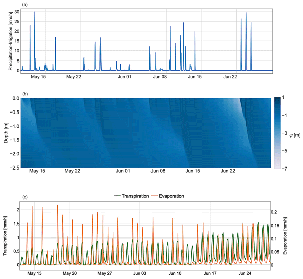
This paper presents GEOSPACE and its 1D implementation: an open-source tool for simulating soil–plant–atmosphere continuum (SPAC) interactions. Using object-oriented programming, GEOSPACE modularizes SPAC processes, focusing on infiltration, evapotranspiration, and root water uptake. The 1D deployment integrates plant transpiration, soil evaporation, and root growth, providing a flexible and validated framework for ecohydrological modeling and applications.
Paolo Filippucci, Luca Brocca, Luca Ciabatta, Hamidreza Mosaffa, Francesco Avanzi, and Christian Massari
Earth Syst. Sci. Data, 17, 5221–5258, https://doi.org/10.5194/essd-17-5221-2025, https://doi.org/10.5194/essd-17-5221-2025, 2025
Short summary
Short summary
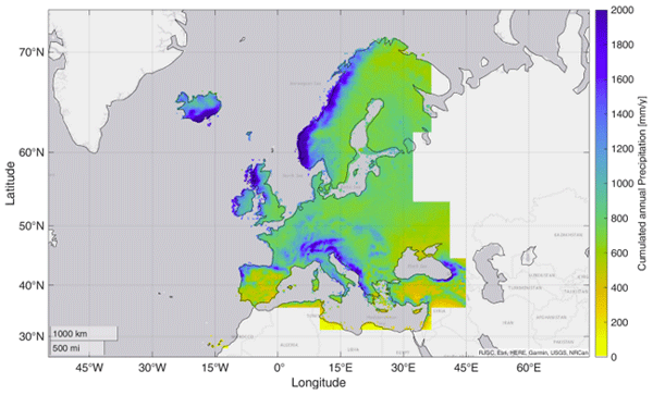
Accurate rainfall data is essential, yet measuring daily precipitation worldwide is challenging. This research presents HYdroclimatic PERformance-enhanced Precipitation (HYPER-P), a dataset combining satellite, ground, and reanalysis data to estimate precipitation at a 1 km scale from 2000 to 2022. HYPER-P improves accuracy, especially in areas with few rain gauges. This dataset supports scientists and decision-makers in understanding and managing water resources more effectively.
Jaime Gaona, Davide Bavera, Guido Fioravanti, Sebastian Hahn, Pietro Stradiotti, Paolo Filippucci, Stefania Camici, Luca Ciabatta, Hamidreza Mosaffa, Silvia Puca, Nicoletta Roberto, and Luca Brocca
Hydrol. Earth Syst. Sci., 29, 3865–3888, https://doi.org/10.5194/hess-29-3865-2025, https://doi.org/10.5194/hess-29-3865-2025, 2025
Short summary
Short summary
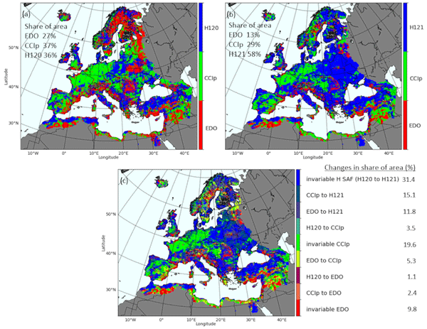
Soil moisture is crucial for the water cycle since it is at the front line of drought. Satellite, model and in situ data help identify soil moisture stress but are challenged by data uncertainties. This study evaluates trends and data coherence of common active/passive microwave sensors and model-based soil moisture data against in situ stations across Europe from 2007 to 2022. Data reliability is increasing, but combining data types improves soil moisture monitoring capabilities.
Ling Zhang, Yanhua Xie, Xiufang Zhu, Qimin Ma, and Luca Brocca
Earth Syst. Sci. Data, 16, 5207–5226, https://doi.org/10.5194/essd-16-5207-2024, https://doi.org/10.5194/essd-16-5207-2024, 2024
Short summary
Short summary
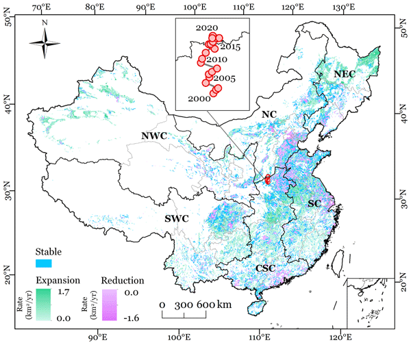
This study presented new annual maps of irrigated cropland in China from 2000 to 2020 (CIrrMap250). These maps were developed by integrating remote sensing data, irrigation statistics and surveys, and an irrigation suitability map. CIrrMap250 achieved high accuracy and outperformed currently available products. The new irrigation maps revealed a clear expansion of China’s irrigation area, with the majority (61%) occurring in the water-unsustainable regions facing severe to extreme water stress.
Jacopo Dari, Paolo Filippucci, and Luca Brocca
Hydrol. Earth Syst. Sci., 28, 2651–2659, https://doi.org/10.5194/hess-28-2651-2024, https://doi.org/10.5194/hess-28-2651-2024, 2024
Short summary
Short summary
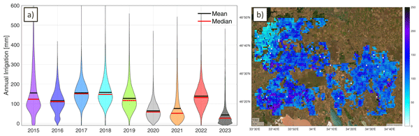
We have developed the first operational system (10 d latency) for estimating irrigation water use from accessible satellite and reanalysis data. As a proof of concept, the method has been implemented over an irrigated area fed by the Kakhovka Reservoir, in Ukraine, which collapsed on June 6, 2023. Estimates for the period 2015–2023 reveal that, as expected, the irrigation season of 2023 was characterized by the lowest amounts of irrigation.
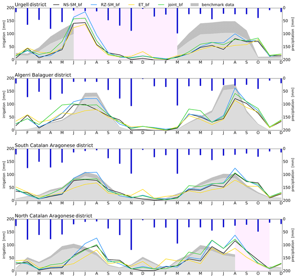
Søren Julsgaard Kragh, Jacopo Dari, Sara Modanesi, Christian Massari, Luca Brocca, Rasmus Fensholt, Simon Stisen, and Julian Koch
Hydrol. Earth Syst. Sci., 28, 441–457, https://doi.org/10.5194/hess-28-441-2024, https://doi.org/10.5194/hess-28-441-2024, 2024
Short summary
Short summary
This study provides a comparison of methodologies to quantify irrigation to enhance regional irrigation estimates. To evaluate the methodologies, we compared various approaches to quantify irrigation using soil moisture, evapotranspiration, or both within a novel baseline framework, together with irrigation estimates from other studies. We show that the synergy from using two equally important components in a joint approach within a baseline framework yields better irrigation estimates.
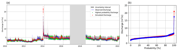
Shima Azimi, Christian Massari, Giuseppe Formetta, Silvia Barbetta, Alberto Tazioli, Davide Fronzi, Sara Modanesi, Angelica Tarpanelli, and Riccardo Rigon
Hydrol. Earth Syst. Sci., 27, 4485–4503, https://doi.org/10.5194/hess-27-4485-2023, https://doi.org/10.5194/hess-27-4485-2023, 2023
Short summary
Short summary
We analyzed the water budget of nested karst catchments using simple methods and modeling. By utilizing the available data on precipitation and discharge, we were able to determine the response lag-time by adopting new techniques. Additionally, we modeled snow cover dynamics and evapotranspiration with the use of Earth observations, providing a concise overview of the water budget for the basin and its subbasins. We have made the data, models, and workflows accessible for further study.
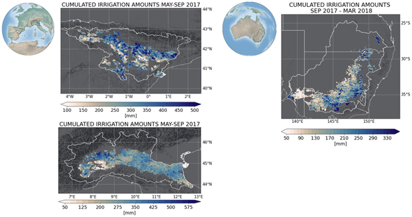
Jacopo Dari, Luca Brocca, Sara Modanesi, Christian Massari, Angelica Tarpanelli, Silvia Barbetta, Raphael Quast, Mariette Vreugdenhil, Vahid Freeman, Anaïs Barella-Ortiz, Pere Quintana-Seguí, David Bretreger, and Espen Volden
Earth Syst. Sci. Data, 15, 1555–1575, https://doi.org/10.5194/essd-15-1555-2023, https://doi.org/10.5194/essd-15-1555-2023, 2023
Short summary
Short summary
Irrigation is the main source of global freshwater consumption. Despite this, a detailed knowledge of irrigation dynamics (i.e., timing, extent of irrigated areas, and amounts of water used) are generally lacking worldwide. Satellites represent a useful tool to fill this knowledge gap and monitor irrigation water from space. In this study, three regional-scale and high-resolution (1 and 6 km) products of irrigation amounts estimated by inverting the satellite soil moisture signals are presented.
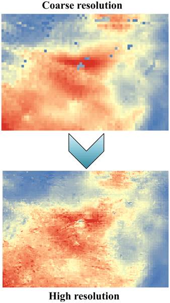
Kunlong He, Wei Zhao, Luca Brocca, and Pere Quintana-Seguí
Hydrol. Earth Syst. Sci., 27, 169–190, https://doi.org/10.5194/hess-27-169-2023, https://doi.org/10.5194/hess-27-169-2023, 2023
Short summary
Short summary
In this study, we developed a soil moisture-based precipitation downscaling (SMPD) method for spatially downscaling the GPM daily precipitation product by exploiting the connection between surface soil moisture and precipitation according to the soil water balance equation. Based on this physical method, the spatial resolution of the daily precipitation product was downscaled to 1 km and the SMPD method shows good potential for the development of the high-resolution precipitation product.
Riccardo Rigon, Giuseppe Formetta, Marialaura Bancheri, Niccolò Tubini, Concetta D'Amato, Olaf David, and Christian Massari
Hydrol. Earth Syst. Sci., 26, 4773–4800, https://doi.org/10.5194/hess-26-4773-2022, https://doi.org/10.5194/hess-26-4773-2022, 2022
Short summary
Short summary
The
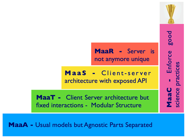
Digital Earth(DE) metaphor is very useful for both end users and hydrological modelers. We analyse different categories of models, with the view of making them part of a Digital eARth Twin Hydrology system (called DARTH). We also stress the idea that DARTHs are not models in and of themselves, rather they need to be built on an appropriate information technology infrastructure. It is remarked that DARTHs have to, by construction, support the open-science movement and its ideas.
Sara Modanesi, Christian Massari, Michel Bechtold, Hans Lievens, Angelica Tarpanelli, Luca Brocca, Luca Zappa, and Gabriëlle J. M. De Lannoy
Hydrol. Earth Syst. Sci., 26, 4685–4706, https://doi.org/10.5194/hess-26-4685-2022, https://doi.org/10.5194/hess-26-4685-2022, 2022
Short summary
Short summary
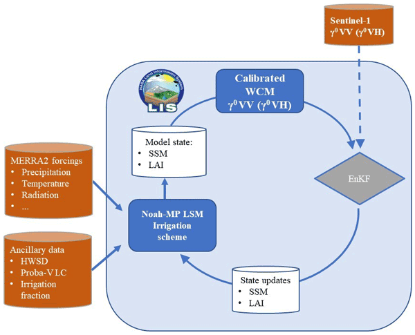
Given the crucial impact of irrigation practices on the water cycle, this study aims at estimating irrigation through the development of an innovative data assimilation system able to ingest high-resolution Sentinel-1 radar observations into the Noah-MP land surface model. The developed methodology has important implications for global water resource management and the comprehension of human impacts on the water cycle and identifies main challenges and outlooks for future research.

Stefania Camici, Gabriele Giuliani, Luca Brocca, Christian Massari, Angelica Tarpanelli, Hassan Hashemi Farahani, Nico Sneeuw, Marco Restano, and Jérôme Benveniste
Geosci. Model Dev., 15, 6935–6956, https://doi.org/10.5194/gmd-15-6935-2022, https://doi.org/10.5194/gmd-15-6935-2022, 2022
Short summary
Short summary
This paper presents an innovative approach, STREAM (SaTellite-based Runoff Evaluation And Mapping), to derive daily river discharge and runoff estimates from satellite observations of soil moisture, precipitation, and terrestrial total water storage anomalies. Potentially useful for multiple operational and scientific applications, the added value of the STREAM approach is the ability to increase knowledge on the natural processes, human activities, and their interactions on the land.
Lorenzo Alfieri, Francesco Avanzi, Fabio Delogu, Simone Gabellani, Giulia Bruno, Lorenzo Campo, Andrea Libertino, Christian Massari, Angelica Tarpanelli, Dominik Rains, Diego G. Miralles, Raphael Quast, Mariette Vreugdenhil, Huan Wu, and Luca Brocca
Hydrol. Earth Syst. Sci., 26, 3921–3939, https://doi.org/10.5194/hess-26-3921-2022, https://doi.org/10.5194/hess-26-3921-2022, 2022
Short summary
Short summary
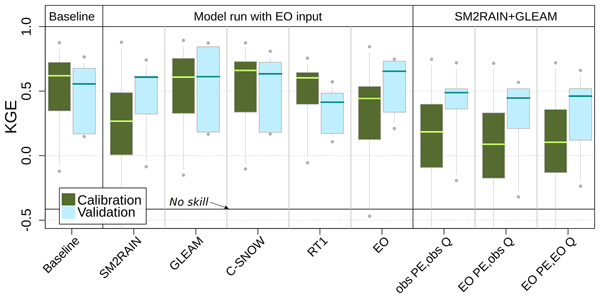
This work shows advances in high-resolution satellite data for hydrology. We performed hydrological simulations for the Po River basin using various satellite products, including precipitation, evaporation, soil moisture, and snow depth. Evaporation and snow depth improved a simulation based on high-quality ground observations. Interestingly, a model calibration relying on satellite data skillfully reproduces observed discharges, paving the way to satellite-driven hydrological applications.
Paolo Filippucci, Luca Brocca, Raphael Quast, Luca Ciabatta, Carla Saltalippi, Wolfgang Wagner, and Angelica Tarpanelli
Hydrol. Earth Syst. Sci., 26, 2481–2497, https://doi.org/10.5194/hess-26-2481-2022, https://doi.org/10.5194/hess-26-2481-2022, 2022
Short summary
Short summary
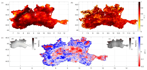
A high-resolution (1 km) rainfall product with 10–30 d temporal resolution was obtained starting from SM data from Sentinel-1. Good performances are achieved using observed data (gauge and radar) over the Po River Valley, Italy, as a benchmark. The comparison with a product characterized by lower spatial resolution (25 km) highlights areas where the high spatial resolution of Sentinel-1 has great benefits. Possible applications include water management, agriculture and index-based insurances.
Niccolò Tubini and Riccardo Rigon
Geosci. Model Dev., 15, 75–104, https://doi.org/10.5194/gmd-15-75-2022, https://doi.org/10.5194/gmd-15-75-2022, 2022
Short summary
Short summary
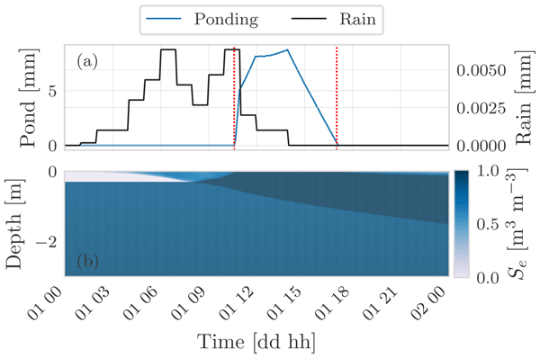
This paper presents WHETGEO and its 1D deployment: a new physically based model simulating the water and energy budgets in a soil column. WHETGEO-1D is intended to be the first building block of a new customisable land-surface model that is integrated with process-based hydrology. WHETGEO is developed as an open-source code and is fully integrated into the GEOframe/OMS3 system, allowing the use of the many ancillary tools it provides.
Wouter Dorigo, Irene Himmelbauer, Daniel Aberer, Lukas Schremmer, Ivana Petrakovic, Luca Zappa, Wolfgang Preimesberger, Angelika Xaver, Frank Annor, Jonas Ardö, Dennis Baldocchi, Marco Bitelli, Günter Blöschl, Heye Bogena, Luca Brocca, Jean-Christophe Calvet, J. Julio Camarero, Giorgio Capello, Minha Choi, Michael C. Cosh, Nick van de Giesen, Istvan Hajdu, Jaakko Ikonen, Karsten H. Jensen, Kasturi Devi Kanniah, Ileen de Kat, Gottfried Kirchengast, Pankaj Kumar Rai, Jenni Kyrouac, Kristine Larson, Suxia Liu, Alexander Loew, Mahta Moghaddam, José Martínez Fernández, Cristian Mattar Bader, Renato Morbidelli, Jan P. Musial, Elise Osenga, Michael A. Palecki, Thierry Pellarin, George P. Petropoulos, Isabella Pfeil, Jarrett Powers, Alan Robock, Christoph Rüdiger, Udo Rummel, Michael Strobel, Zhongbo Su, Ryan Sullivan, Torbern Tagesson, Andrej Varlagin, Mariette Vreugdenhil, Jeffrey Walker, Jun Wen, Fred Wenger, Jean Pierre Wigneron, Mel Woods, Kun Yang, Yijian Zeng, Xiang Zhang, Marek Zreda, Stephan Dietrich, Alexander Gruber, Peter van Oevelen, Wolfgang Wagner, Klaus Scipal, Matthias Drusch, and Roberto Sabia
Hydrol. Earth Syst. Sci., 25, 5749–5804, https://doi.org/10.5194/hess-25-5749-2021, https://doi.org/10.5194/hess-25-5749-2021, 2021
Short summary
Short summary
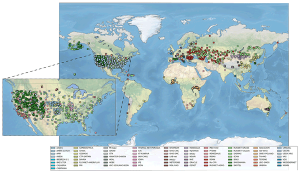
The International Soil Moisture Network (ISMN) is a community-based open-access data portal for soil water measurements taken at the ground and is accessible at https://ismn.earth. Over 1000 scientific publications and thousands of users have made use of the ISMN. The scope of this paper is to inform readers about the data and functionality of the ISMN and to provide a review of the scientific progress facilitated through the ISMN with the scope to shape future research and operations.
Daniele Masseroni, Stefania Camici, Alessio Cislaghi, Giorgio Vacchiano, Christian Massari, and Luca Brocca
Hydrol. Earth Syst. Sci., 25, 5589–5601, https://doi.org/10.5194/hess-25-5589-2021, https://doi.org/10.5194/hess-25-5589-2021, 2021
Short summary
Short summary
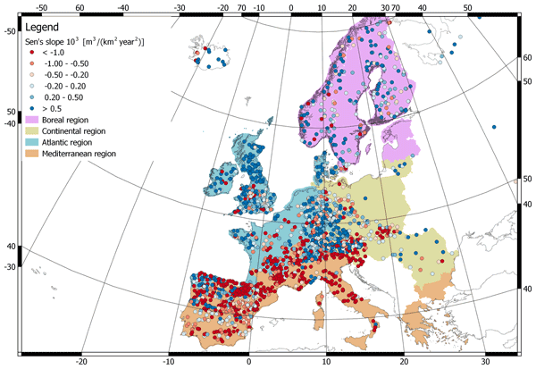
We evaluate 63 years of changes in annual streamflow volume across Europe, using a data set of more than 3000 stations, with a special focus on the Mediterranean basin. The results show decreasing (increasing) volumes in the southern (northern) regions. These trends are strongly consistent with the changes in temperature and precipitation.
Cited articles
Abera, W., Formetta, G., Brocca, L., and Rigon, R.: Complimentary material and data, https://doi.org/10.5281/zenodo.264004, 2017.
Abera, W., Antonello, A., Franceschi, S., Formetta, G., and Rigon, R.: The uDig Spatial Toolbox for hydro-geomorphic analysis, British Society for Geomorphology, London, UK, in: geomorphological techniques (online Edn.), edited by: Clarke, L. E. and Nield, J. M., 2014.
Abera, W., Brocca, L., and Rigon, R.: Comparative evaluation of different satellite rainfall estimation products and bias correction in the Upper Blue Nile (UBN) basin, Atmos. Res., 178, 471–483, 2016.
Abera, W., Formetta, G., Borga, M., and Rigon, R.: Estimating the water budget components and their variability in a pre-alpine basin with JGrass-NewAGE, Adv. Water Resour., 104, 37–54, 2017.
Abtew, W., Melesse, A. M., and Dessalegne, T.: Spatial, inter and intra-annual variability of the Upper Blue Nile Basin rainfall, Hydrol. Process., 23, 3075–3082, 2009.
Abu-Zeid, M. A. and Biswas, A. K.: River basin planning and management, Oxford University Press, Oxford, UK, 1996.
Allam, M. M., Jain Figueroa, A., McLaughlin, D. B., and Eltahir, E. A.: Estimation of evaporation over the upper Blue Nile basin by combining observations from satellites and river flow gauges, Water Resour. Res., 52, 644–659 https://doi.org/10.1002/2015WR017251, 2016.
Allen, R. G., Pereira, L. S., Raes, D., and Smith, M.: Crop evapotranspiration-Guidelines for computing crop water requirements-FAO Irrigation and drainage paper 56, FAO, Rome, 300, 6541, 1998.
Andrew, M. E., Wulder, M. A., and Nelson, T. A.: Potential contributions of remote sensing to ecosystem service assessments, Prog. Phys. Geog., 38, 328–353, 2014.
Arking, A.: The radiative effects of clouds and their impact on climate, B. Am. Meteorol. Soc., 72, 795–813, 1991.
Assouline, S., Li, D., Tyler, S., Tanny, J., Cohen, S., Bou-Zeid, E., Parlange, M., and Katul, G. G.: On the variability of the Priestley-Taylor coefficient over water bodies, Water Resour. Res., 52, 150–163, https://doi.org/10.1002/2015WR017504, 2016.
Bellerby, T.: Satellite rainfall uncertainty estimation using an artificial neural network, J. Hydrometeorol., 8, 1397–1412, 2007.
Bewket, W. and Sterk, G.: Dynamics in land cover and its effect on stream flow in the Chemoga watershed, Blue Nile basin, Ethiopia, Hydrol. Process., 19, 445–458, 2005.
Billah, M. M., Goodall, J. L., Narayan, U., Reager, J., Lakshmi, V., and Famiglietti, J. S.: A methodology for evaluating evapotranspiration estimates at the watershed-scale using GRACE, J. Hydrol., 523, 574–586, 2015.
Block, P. and Rajagopalan, B.: Interannual variability and ensemble forecast of Upper Blue Nile Basin Kiremt season precipitation, J. Hydrometeorol., 8, 327–343, 2007.
Boyle, D. P., Gupta, H. V., Sorooshian, S., Koren, V., Zhang, Z., and Smith, M.: Toward improved streamflow forecasts: Value of semidistributed modeling, Water Resour. Res., 37, 2749–2759, 2001.
Brocca, L., Moramarco, T., Melone, F., and Wagner, W.: A new method for rainfall estimation through soil moisture observations, Geophys. Res. Lett., 40, 853–858, 2013.
Brocca, L., Ciabatta, L., Massari, C., Moramarco, T., Hahn, S., Hasenauer, S., Kidd, R., Dorigo, W., Wagner, W., and Levizzani, V.: Soil as a natural rain gauge: estimating global rainfall from satellite soil moisture data, J. Geophys. Res.-Atmos., 119, 5128–5141, 2014.
Brocca, L., Pellarin, T., Crow, W. T., Ciabatta, L., Massari, C., Ryu, D., Su, C.-H., Rüdiger, C., and Kerr, Y.: Rainfall estimation by inverting SMOS soil moisture estimates: A comparison of different methods over Australia, J. Geophys. Res.-Atmos., 121, 12062–12079, https://doi.org/10.1002/2016JD025382, 2016.
Brutsaert, W.: Hydrology: an introduction, Cambridge University Press, Cambridge, UK, 2005.
Budyko, M. I: Climate and Life, International Geophysics Series, 18, Academic Press, Oxford, UK, 1978.
Ciabatta, L., Marra, A. C., Panegrossi, G., Casella, D., Sanò, P., Dietrich, S., Massari, C., and Brocca, L.: Daily precipitation estimation through different microwave sensors: Verification study over Italy, J. Hydrol., 545, 436–450, https://doi.org/10.1016/j.jhydrol.2016.12.057, 2017.
Conway, D.: A water balance model of the Upper Blue Nile in Ethiopia, Hydrolog. Sci. J., 42, 265–286, 1997.
Conway, D.: The climate and hydrology of the Upper Blue Nile River, Geogr. J., 166, 49–62, 2000.
Conway, D.: From headwater tributaries to international river: observing and adapting to climate variability and change in the Nile basin, Global Environ. Chang., 15, 99–114, 2005.
Conway, D. and Hulme, M.: Recent fluctuations in precipitation and runoff over the Nile sub-basins and their impact on main Nile discharge, Climatic Change, 25, 127–151, 1993.
David, O., Ascough Ii, J., Lloyd, W., Green, T., Rojas, K., Leavesley, G., and Ahuja, L.: A software engineering perspective on environmental modeling framework design: The Object Modeling System, Environ. Modell. Softw., 39, 201–213, 2013.
Dessie, M., Verhoest, N. E. C., Pauwels, V. R. N., Admasu, T., Poesen, J., Adgo, E., Deckers, J., and Nyssen, J.: Analyzing runoff processes through conceptual hydrological modeling in the Upper Blue Nile Basin, Ethiopia, Hydrol. Earth Syst. Sci., 18, 5149-5167, https://doi.org/10.5194/hess-18-5149-2014, 2014.
Döll, P., Fritsche, M., Eicker, A., and Schmied, H. M.: Seasonal water storage variations as impacted by water abstractions: comparing the output of a global hydrological model with GRACE and GPS observations, Surv. Geophys., 35, 1311–1331, 2014.
Durand, M., Fu, L.-L., Lettenmaier, D. P., Alsdorf, D. E., Rodriguez, E., and Esteban Fernandez, D.: The surface water and ocean topography mission: Observing terrestrial surface water and oceanic submesoscale eddies, P. IEEE, 98, 766–779, 2010.
Easton, Z. M., Fuka, D. R., White, E. D., Collick, A. S., Biruk Ashagre, B., McCartney, M., Awulachew, S. B., Ahmed, A. A., and Steenhuis, T. S.: A multi basin SWAT model analysis of runoff and sedimentation in the Blue Nile, Ethiopia, Hydrol. Earth Syst. Sci., 14, 1827–1841, https://doi.org/10.5194/hess-14-1827-2010, 2010.
Feddes, R. A., Hoff, H., Bruen, M., Dawson, T., de Rosnay, P., Dirmeyer, P., Jackson, R. B., Kabat, P., Kleidon, A., Lilly, A., and Pitman, A. J.: Modeling root water uptake in hydrological and climate models, B. Am. Meteorol. Soc., 82, 2797–2809, 2001.
Fenicia, F., McDonnell, J. J., and Savenije, H. H.: Learning from model improvement: On the contribution of complementary data to process understanding, Water Resour. Res., 44, W06419, https://doi.org/10.1029/2007WR006386, 2008.
Fisher, J. B., Tu, K. P., and Baldocchi, D. D.: Global estimates of the land–atmosphere water flux based on monthly AVHRR and ISLSCP-II data, validated at 16 FLUXNET sites, Remote Sens. Environ., 112, 901–919, 2008.
Formetta, G., Mantilla, R., Franceschi, S., Antonello, A., and Rigon, R.: The JGrass-NewAge system for forecasting and managing the hydrological budgets at the basin scale: models of flow generation and propagation/routing, Geosci. Model Dev., 4, 943–955, https://doi.org/10.5194/gmd-4-943-2011, 2011.
Formetta, G., Rigon, R., Chávez, J. L., and David, O.: Modeling shortwave solar radiation using the JGrass-NewAge system, Geosci. Model Dev., 6, 915–928, https://doi.org/10.5194/gmd-6-915-2013, 2013.
Formetta, G., Antonello, A., Franceschi, S., David, O., and Rigon, R.: Digital watershed representation within the NewAge-JGrass system, Boletín Geológico y minero, 125, 369–379, 2014a.
Formetta, G., Kampf, S. K., David, O., and Rigon, R.: Snow water equivalent modeling components in NewAge-JGrass, Geosci. Model Dev., 7, 725–736, https://doi.org/10.5194/gmd-7-725-2014, 2014b.
Formetta, G., Bancheri, M., David, O., and Rigon, R.: Performance of site-specific parameterizations of longwave radiation, Hydrol. Earth Syst. Sci., 20, 4641–4654, https://doi.org/10.5194/hess-20-4641-2016, 2016.
Gao, H., Tang, Q., Ferguson, C. R., Wood, E. F., and Lettenmaier, D. P.: Estimating the water budget of major US river basins via remote sensing, Int. J. Remote Sens. 31, 3955–3978, 2010.
Gash, J.: An analytical model of rainfall interception by forests, Q. J. Roy. Meteor. Soc., 105, 43–55, 1979.
Gebremicael, T., Mohamed, Y., Betrie, G., van der Zaag, P., and Teferi, E.: Trend analysis of runoff and sediment fluxes in the Upper Blue Nile basin: A combined analysis of statistical tests, physically-based models and landuse maps, J. Hydrol., 482, 57–68, 2013.
Goovaerts, P.: Geostatistics for natural resources evaluation, Oxford University Press, Oxford, UK, 1997.
Goovaerts, P.: Geostatistics in soil science: state-of-the-art and perspectives, Geoderma, 89, 1–45, 1999.
Goovaerts, P.: Geostatistical approaches for incorporating elevation into the spatial interpolation of rainfall, J. Hydrol., 228, 113–129, 2000.
Guntner, A.: Improvement of global hydrological models using GRACE data, Surv. Geophys., 29, 375–397, 2008.
Gupta, H. V., Sorooshian, S., and Yapo, P. O.: Status of automatic calibration for hydrologic models: Comparison with multilevel expert calibration, J. Hydrol. Eng., 4, 135–143, 1999.
Gupta, H. V., Kling, H., Yilmaz, K. K., and Martinez, G. F.: Decomposition of the mean squared error and NSE performance criteria: Implications for improving hydrological modelling, J. Hydrol., 377, 80–91, 2009.
Haberlandt, U.: Geostatistical interpolation of hourly precipitation from rain gauges and radar for a large-scale extreme rainfall event, J. Hydrol., 332, 144–157, 2007.
Hall, J. W., Grey, D., Garrick, D., Fung, F., Brown, C., Dadson, S. J., and Sadoff, C. W.: Coping with the curse of freshwater variability, Science, 346, 429–430, 2014.
Han, S.-C., Kim, H., Yeo, I.-Y., Yeh, P., Oki, T., Seo, K.-W., Alsdorf, D., and Luthcke, S. B.: Dynamics of surface water storage in the Amazon inferred from measurements of inter-satellite distance change, Geophys. Res. Lett., 36, L09403, https://doi.org/10.1029/2009GL037910, 2009.
Hay, L. E., Leavesley, G. H., Clark, M. P., Markstrom, S. L., Viger, R. J., and Umemoto, M.: Step wise, multiple objective calibration of a hydrologic model for a snowmelt dominated basin, J. Am. Water Resour. As., 42, 877–890, 2006.
Hong, Y., Hsu, K.-L., Moradkhani, H., and Sorooshian, S.: Uncertainty quantification of satellite precipitation estimation and Monte Carlo assessment of the error propagation into hydrologic response, Water Resour. Res., 42, W08421, https://doi.org/10.1029/2005WR004398, 2006.
Huffman, G. J., Bolvin, D. T., Nelkin, E. J., Wolff, D. B., Adler, R. F., Gu, G., Hong, Y., Bowman, K. P., and Stocker, E. F.: The TRMM multisatellite precipitation analysis (TMPA): Quasi-global, multiyear, combined-sensor precipitation estimates at fine scales, J. Hydrometeorol., 8, 38–55, 2007.
Jarmain, C., Mengitsu, M., Jewitt, G. P. W., Kongo, V., and Bastiaanssen, W.: A methodology for near-real time spatial estimation of evaporation: Report to the Water Research Commission, Pretoria, South Africa, 2009.
Jiang, D., Wang, J., Huang, Y., Zhou, K., Ding, X., and Fu, J.: The review of GRACE data applications in terrestrial hydrology monitoring, Advances in Meteorology, 2014, 725131, https://doi.org/10.1155/2014/725131, 2014.
Johnston, R. M. and McCartney, M.: Inventory of water storage types in the Blue Nile and Volta river basins, vol. 140, IWMI, Colombo, Sri Lanka, https://doi.org/10.5337/2010.214, 2010.
Joyce, R. J., Janowiak, J. E., Arkin, P. A., and Xie, P.: CMORPH: A method that produces global precipitation estimates from passive microwave and infrared data at high spatial and temporal resolution, J. Hydrometeorol., 5, 487–503, 2004.
Karlsson, K.-G., Riihelä, A., Müller, R., Meirink, J. F., Sedlar, J., Stengel, M., Lockhoff, M., Trentmann, J., Kaspar, F., Hollmann, R., and Wolters, E.: CLARA-A1: a cloud, albedo, and radiation dataset from 28 yr of global AVHRR data, Atmos. Chem. Phys., 13, 5351–5367, https://doi.org/10.5194/acp-13-5351-2013, 2013.
Kebede, S., Travi, Y., Alemayehu, T., and Marc, V.: Water balance of Lake Tana and its sensitivity to fluctuations in rainfall, Blue Nile basin, Ethiopia, J. Hydrol., 316, 233–247, 2006.
Kennedy, J. and Eberhart, R.: Particle swarm optimization, in: Proceedings of IEEE international conference on neural networks, vol. 4, Perth, Australia, 1942–1948, 1995.
Kim, J. and Hogue, T. S.: Evaluation of a MODIS-based potential evapotranspiration product at the point scale, J. Hydrometeorol., 9, 444–460, 2008.
Kim, U. and Kaluarachchi, J. J.: Application of parameter estimation and regionalization methodologies to ungauged basins of the Upper Blue Nile River Basin, Ethiopia, J. Hydrol., 362, 39–56, 2008.
Kim, U. and Kaluarachchi, J. J: Climate Change Impacts on Water Resources in the Upper Blue Nile River Basin, Ethiopia, J. Am. Water Resour. As., 45, 1361–1378, 2009.
Kim, U., Kaluarachchi, J. J., and Smakhtin, V. U.: Generation of Monthly Precipitation Under Climate Change for the Upper Blue Nile River Basin, Ethiopia, J. Am. Water Resour. As., 44, 1231–1247, 2008.
Kjærsgaard, J. H., Cuenca, R. H., Martínez-Cob, A., Gavilán, P., Plauborg, F., Mollerup, M., and Hansen, S.: Comparison of the performance of net radiation calculation models, Theor. Appl. Climatol., 98, 57–66, 2009.
Kling, H., Fuchs, M., and Paulin, M.: Runoff conditions in the upper Danube basin under an ensemble of climate change scenarios, J. Hydrol., 424, 264–277, 2012.
Koster, R. D., Brocca, L., Crow, W. T., Burgin, M. S., and De Lannoy, G. J.: Precipitation estimation using L-band and C-band soil moisture retrievals, Water Resour. Res., 52, 7213–7225, 2016.
Kummerow, C., Barnes, W., Kozu, T., Shiue, J., and Simpson, J.: The tropical rainfall measuring mission (TRMM) sensor package, J. Atmos. Ocean. Tech., 15, 809–817, 1998.
Landerer, F. and Swenson, S.: Accuracy of scaled GRACE terrestrial water storage estimates, Water Resour. Res., 48, W04531, https://doi.org/10.1029/2011WR011453, 2012.
Martens, B., Miralles, D. G., Lievens, H., van der Schalie, R., de Jeu, R. A. M., Fernández-Prieto, D., Beck, H. E., Dorigo, W. A., and Verhoest, N. E. C.: GLEAM v3: satellite-based land evaporation and root-zone soil moisture, Geosci. Model Dev., 10, 1903–1925, https://doi.org/10.5194/gmd-10-1903-2017, 2017.
McCabe, M. F., Ershadi, A., Jimenez, C., Miralles, D. G., Michel, D., and Wood, E. F.: The GEWEX LandFlux project: evaluation of model evaporation using tower-based and globally gridded forcing data, Geosci. Model Dev., 9, 283–305, https://doi.org/10.5194/gmd-9-283-2016, 2016.
Mellander, P.-E., Gebrehiwot, S. G., Gardenas, A. I., Bewket, W., and Bishop, K.: Summer rains and dry seasons in the Upper Blue Nile Basin: the predictability of half a century of past and future spatiotemporal patterns, PloS One, 8, 1932–6203, 2013.
Mengistu, D. T. and Sorteberg, A.: Sensitivity of SWAT simulated streamflow to climatic changes within the Eastern Nile River basin, Hydrol. Earth Syst. Sci., 16, 391–407, https://doi.org/10.5194/hess-16-391-2012, 2012.
Michelangeli, P.-A., Vrac, M., and Loukos, H.: Probabilistic downscaling approaches: Application to wind cumulative distribution functions, Geophys. Res. Lett., 36, L11708, https://doi.org/10.1029/2009GL038401, 2009.
Miralles, D. G., Holmes, T. R. H., De Jeu, R. A. M., Gash, J. H., Meesters, A. G. C. A., and Dolman, A. J.: Global land-surface evaporation estimated from satellite-based observations, Hydrol. Earth Syst. Sci., 15, 453–469, https://doi.org/10.5194/hess-15-453-2011, 2011a.
Miralles, D. G., De Jeu, R. A. M., Gash, J. H., Holmes, T. R. H., and Dolman, A. J.: Magnitude and variability of land evaporation and its components at the global scale, Hydrol. Earth Syst. Sci., 15, 967–981, https://doi.org/10.5194/hess-15-967-2011, 2011b.
Mishra, A. and Hata, T.: A grid-based runoff generation and flow routing model for the upper Blue Nile basin, Hydrolog. Sci. J., 51, 191–206, 2006.
Mishra, A., Hata, T., and Abdelhadi, A.: Models for recession flows in the upper Blue Nile River, Hydrol. Process., 18, 2773–2786, 2004.
Monteith, J. L.: Evaporation and environment, Symp. Soc. Exp. Biol, vol. 19, p. 4, 1965.
Moore, R.: The probability-distributed principle and runoff production at point and basin scales, Hydrolog. Sci. J., 30, 273–297, 1985.
Moriasi, D., Arnold, J., Van Liew, M., Bingner, R., Harmel, R., and Veith, T.: Model evaluation guidelines for systematic quantification of accuracy in watershed simulations, T. ASABE, 50, 885–900, 2007.
Mu, Q., Heinsch, F. A., Zhao, M., and Running, S. W.: Development of a global evapotranspiration algorithm based on MODIS and global meteorology data, Remote Sens. Environ., 111, 519–536, 2007.
Mu, Q., Zhao, M., and Running, S. W.: Improvements to a MODIS global terrestrial evapotranspiration algorithm, Remote Sens. Environ., 115, 1781–1800, 2011.
Muskett, R. R. and Romanovsky, V. E.: Groundwater storage changes in arctic permafrost watersheds from GRACE and in situ measurements, Environ. Res. Lett., 4, 045009, 2009.
Nash, J. E. and Sutcliffe, J. V.: River flow forecasting through conceptual models part I – discussion of principles, J. Hydrol., 10, 282–290, 1970.
Norman, J. M., Kustas, W. P., and Humes, K. S.: Source approach for estimating soil and vegetation energy fluxes in observations of directional radiometric surface temperature, Agr. Forest Meteorol., 77, 263–293, 1995.
Paiva, R. C., Durand, M. T., and Hossain, F.: Spatiotemporal interpolation of discharge across a river network by using synthetic SWOT satellite data, Water Resour. Res., 51, 430–449, 2015.
Pavelsky, T. M., Durand, M. T., Andreadis, K. M., Beighley, R. E., Paiva, R. C., Allen, G. H., and Miller, Z. F.: Assessing the potential global extent of SWOT river discharge observations, J. Hydrol., 519, 1516–1525, 2014.
Pejam, M., Arain, M., and McCaughey, J.: Energy and water vapour exchanges over a mixedwood boreal forest in Ontario, Canada, Hydrol. Process., 20, 3709–3724, 2006.
Pimentel, D., Berger, B., Filiberto, D., Newton, M., Wolfe, B., Karabinakis, E., Clark, S., Poon, E., Abbett, E., and Nandagopal, S.: Water resources: agricultural and environmental issues, BioScience, 54, 909–918, 2004.
Population Census Commission: Summary and statistics report of the 2007 population and housing census, United Nations Population Fund (UNFPA), Addis Ababa, Ethiopia, 2008.
Priestley, C. and Taylor, R.: On the assessment of surface heat flux and evaporation using large-scale parameters, Mon. Weather Rev., 100, 81–92, 1972.
Ramillien, G., Famiglietti, J. S., and Wahr, J.: Detection of continental hydrology and glaciology signals from GRACE: a review, Surv. Geophys., 29, 361–374, 2008.
Rientjes, T. H. M., Haile, A. T., Kebede, E., Mannaerts, C. M. M., Habib, E., and Steenhuis, T. S.: Changes in land cover, rainfall and stream flow in Upper Gilgel Abbay catchment, Blue Nile basin – Ethiopia, Hydrol. Earth Syst. Sci., 15, 1979–1989, https://doi.org/10.5194/hess-15-1979-2011, 2011.
Rodell, M., Famiglietti, J., Chen, J., Seneviratne, S., Viterbo, P., Holl, S., and Wilson, C.: Basin scale estimates of evapotranspiration using GRACE and other observations, Geophys. Res. Lett., 31, L20504, https://doi.org/10.1029/2004GL020873, 2004.
Rodell, M., Chen, J., Kato, H., Famiglietti, J. S., Nigro, J., and Wilson, C. R.: Estimating groundwater storage changes in the Mississippi River basin (USA) using GRACE, Hydrogeol. J., 15, 159–166, 2007.
Sahoo, A. K., Pan, M., Troy, T. J., Vinukollu, R. K., Sheffield, J., and Wood, E. F.: Reconciling the global terrestrial water budget using satellite remote sensing, Remote Sens. Environ., 115, 1850–1865, 2011.
Schaefli, B. and Gupta, H. V.: Do Nash values have value?, Hydrol. Process., 21, 2075–2080, 2007.
Schiemann, R., Erdin, R., Willi, M., Frei, C., Berenguer, M., and Sempere-Torres, D.: Geostatistical radar-raingauge combination with nonparametric correlograms: methodological considerations and application in Switzerland, Hydrol. Earth Syst. Sci., 15, 1515–1536, https://doi.org/10.5194/hess-15-1515-2011, 2011.
Schulz, J., Albert, P., Behr, H.-D., Caprion, D., Deneke, H., Dewitte, S., Dürr, B., Fuchs, P., Gratzki, A., Hechler, P., Hollmann, R., Johnston, S., Karlsson, K.-G., Manninen, T., Müller, R., Reuter, M., Riihelä, A., Roebeling, R., Selbach, N., Tetzlaff, A., Thomas, W., Werscheck, M., Wolters, E., and Zelenka, A.: Operational climate monitoring from space: the EUMETSAT Satellite Application Facility on Climate Monitoring (CM-SAF), Atmos. Chem. Phys., 9, 1687–1709, https://doi.org/10.5194/acp-9-1687-2009, 2009.
Setegn, S. G., Srinivasan, R., and Dargahi, B.: Hydrological modelling in the Lake Tana Basin, Ethiopia using SWAT model, The Open Hydrology Journal, 2008, 49–62, https://doi.org/10.2174/1874378100802010049, 2008.
Sheffield, J., Ferguson, C. R., Troy, T. J., Wood, E. F., and McCabe, M. F.: Closing the terrestrial water budget from satellite remote sensing, Geophys. Res. Lett., 36, L07403, https://doi.org/10.1029/2009GL037338, 2009.
Sheffield, J., Wood, E. F., and Munoz-Arriola, F.: Long-term regional estimates of evapotranspiration for Mexico based on downscaled ISCCP data, J. Hydrometeorol., 11, 253–275, 2010.
Sheffield, J., Wood, E. F., and Roderick, M. L.: Little change in global drought over the past 60 years, Nature, 491, 435–438, 2012.
Sorooshian, S., Hsu, K.-L., Gao, X., Gupta, H. V., Imam, B., and Braithwaite, D.: Evaluation of PERSIANN system satellite-based estimates of tropical rainfall, B. Am. Meteorol. Soc., 81, 2035–2046, 2000.
Steenhuis, T. S., Collick, A. S., Easton, Z. M., Leggesse, E. S., Bayabil, H. K., White, E. D., Awulachew, S. B., Adgo, E., and Ahmed, A. A.: Predicting discharge and sediment for the Abay (Blue Nile) with a simple model, Hydrol. Process., 23, 3728–3737, 2009.
Stehr, A., Debels, P., Romero, F., and Alcayaga, H.: Hydrological modelling with SWAT under conditions of limited data availability: evaluation of results from a Chilean case study, Hydrolog. Sci. J., 53, 588–601, 2008.
Swenson, S. and Wahr, J.: Post-processing removal of correlated errors in GRACE data, Geophys. Res. Lett., 33, L08402, https://doi.org/10.1029/2005GL025285, 2006.
Syed, T. H., Famiglietti, J. S., Rodell, M., Chen, J., and Wilson, C. R.: Analysis of terrestrial water storage changes from GRACE and GLDAS, Water Resour. Res., 44, W02433, https://doi.org/10.1029/2006WR005779, 2008.
Tarpanelli, A., Brocca, L., Barbetta, S., Faruolo, M., Lacava, T., and Moramarco, T.: Coupling MODIS and radar altimetry data for discharge estimation in poorly gauged river basins, IEEE J. Sel. Top. Appl., 8, 141–148, 2015.
Taye, M. T. and Willems, P.: Influence of climate variability on representative QDF predictions of the upper Blue Nile basin, J. Hydrol., 411, 355–365, 2011.
Teferi, E., Uhlenbrook, S., Bewket, W., Wenninger, J., and Simane, B.: The use of remote sensing to quantify wetland loss in the Choke Mountain range, Upper Blue Nile basin, Ethiopia, Hydrol. Earth Syst. Sci., 14, 2415–2428, https://doi.org/10.5194/hess-14-2415-2010, 2010.
Tekleab, S., Uhlenbrook, S., Mohamed, Y., Savenije, H. H. G., Temesgen, M., and Wenninger, J.: Water balance modeling of Upper Blue Nile catchments using a top-down approach, Hydrol. Earth Syst. Sci., 15, 2179–2193, https://doi.org/10.5194/hess-15-2179-2011, 2011.
Thiemig, V., Rojas, R., Zambrano-Bigiarini, M., and De Roo, A.: Hydrological evaluation of satellite-based rainfall estimates over the Volta and Baro-Akobo Basin, J. Hydrol., 499, 324–338, 2013.
Uhlenbrook, S., Mohamed, Y., and Gragne, A. S.: Analyzing catchment behavior through catchment modeling in the Gilgel Abay, Upper Blue Nile River Basin, Ethiopia, Hydrol. Earth Syst. Sci., 14, 2153–2165, https://doi.org/10.5194/hess-14-2153-2010, 2010.
Van Delft, G., El Serafy, G., and Heemink, A.: The ensemble particle filter (EnPF) in rainfall-runoff models, Stoch. Env. Res. Risk A., 23, 1203–1211, 2009.
Van Dijk, A. I., Brakenridge, G. R., Kettner, A. J., Beck, H. E., De Groeve, T., and Schellekens, J.: River gauging at global scale using optical and passive microwave remote sensing, Water Resour. Res., 52, 6404–6418, 2016.
Viste, E., Korecha, D., and Sorteberg, A.: Recent drought and precipitation tendencies in Ethiopia, Theor. Appl. Climatol., 112, 535–551, 2013.
Vrugt, J. A., Ter Braak, C., Diks, C., Robinson, B. A., Hyman, J. M., and Higdon, D.: Accelerating Markov chain Monte Carlo simulation by differential evolution with self-adaptive randomized subspace sampling, Int. J. Nonlin. Sci. Num., 10, 273–290, 2009.
Wale, A., Rientjes, T., Gieske, A., and Getachew, H.: Ungauged catchment contributions to Lake Tana's water balance, Hydrol. Process., 23, 3682–3693, 2009.
Wang, H., Guan, H., Gutiérrez-Jurado, H. A., and Simmons, C. T.: Examination of water budget using satellite products over Australia, J. Hydrol., 511, 546–554, 2014.
Zambrano-Bigiarini, M.: hydroGOF: Goodness-of-fit functions for comparison of simulated and observed hydrological time series, R package version 0.3-7, 2013.
Short summary
This study documents a state-of-the-art estimation of the water budget (rainfall, evapotranspiration, discharge, and soil and groundwater storage) components for the Upper Blue Nile river. The budget uses various JGrass-NewAGE components, satellite data and all ground measurements available. The analysis shows that precipitation of the basin is 1360 ± 230 mm per year. Evapotranspiration accounts for 56 %, runoff is 33 %, and storage varies from minus 10 % to plus 17 % of the annual water budget.
This study documents a state-of-the-art estimation of the water budget (rainfall,...


