
Articles | Volume 20, issue 1
https://doi.org/10.5194/hess-20-359-2016
© Author(s) 2016. This work is distributed under
the Creative Commons Attribution 3.0 License.
the Creative Commons Attribution 3.0 License.
https://doi.org/10.5194/hess-20-359-2016
© Author(s) 2016. This work is distributed under
the Creative Commons Attribution 3.0 License.
the Creative Commons Attribution 3.0 License.
Research article
| 
20 Jan 2016
Research article |
| 20 Jan 2016
Estimation of deep infiltration in unsaturated limestone environments using cave lidar and drip count data
K. Mahmud
CORRESPONDING AUTHOR
Connected Waters Initiative Research Centre, UNSW
Australia, Sydney, Australia
G. Mariethoz
Institute of Earth Surface Dynamics, University of
Lausanne, Lausanne, Switzerland
Connected Waters Initiative Research Centre, UNSW
Australia, Sydney, Australia
P. C. Treble
Institute for Environmental Research, Australian Nuclear
Science and Technology Organisation, Lucas Heights, Sydney,
Australia
M. Markowska
Connected Waters Initiative Research Centre, UNSW
Australia, Sydney, Australia
Institute for Environmental Research, Australian Nuclear
Science and Technology Organisation, Lucas Heights, Sydney,
Australia
E. McGuire
Department of Parks and Wildlife, Busselton, WA,
Australia
Related authors
No articles found.
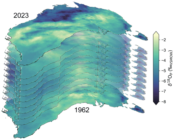
Georgina Falster, Gab Abramowitz, Sanaa Hobeichi, Catherine Hughes, Pauline Treble, Nerilie J. Abram, Michael I. Bird, Alexandre Cauquoin, Bronwyn Dixon, Russell Drysdale, Chenhui Jin, Niels Munksgaard, Bernadette Proemse, Jonathan J. Tyler, Martin Werner, and Carol V. Tadros
Hydrol. Earth Syst. Sci., 30, 289–315, https://doi.org/10.5194/hess-30-289-2026, https://doi.org/10.5194/hess-30-289-2026, 2026
Short summary
Short summary
We used a random forest approach to produce estimates of monthly precipitation stable isotope variability from 1962–2023, at high resolution across the entire Australian continent. Comprehensive skill and sensitivity testing shows that our random forest models skilfully predict precipitation isotope values in places and times that observations are not available. We make all outputs freely available, facilitating use in fields from ecology and hydrology to archaeology and forensic science.
Yining Zang, Pauline C. Treble, Kei Yoshimura, Jayson Gabriel Pinza, Fengbo Zhang, Kübra Özdemir Çallı, Xiaojun Mei, Admin Husic, Alena Gessert, Andrej Stroj, Bartolomé Andreo, Bernard Ladouche, Christine Stumpp, Diana Mance, Eleni Zagana, Fen Huang, Giuseppe Sappa, Harald Kunstmann, Heike Brielmann, Hong Zhou, Huaying Wu, Jakob Garvelmann, James Berglund, Jean-Baptiste Charlier, Jens Lange, Juan Antonio Barberá Fornell, Junbing Pu, Konstantina Katsanou, Kun Ren, Laura Toran, Laurence Gill, Maria Filippini, Martin Kralik, Matías Mudarra Martínez, Min Zhao, Mingming Luo, Nico Goldscheider, Nikolaos Lambrakis, Pantaleone De Vita, Qiong Xiao, Shi Yu, Silvia Iacurto, Silvio Coda, Ted McCormack, Vincenzo Allocca, W. George Darling, Walter D’Alessandro, Xulei Guo, Yundi Hu, Zhijun Wang, Eva Kaminsky, Jiří Faimon, Marek Lang, Pavel Pracný, and Andreas Hartmann
Earth Syst. Sci. Data Discuss., https://doi.org/10.5194/essd-2025-812, https://doi.org/10.5194/essd-2025-812, 2026
Preprint under review for ESSD
Short summary
Short summary
We developed the first global database of water from karst springs and cave drips that records different forms of oxygen and hydrogen, which naturally trace how rainwater moves through rocks. By gathering and checking thousands of measurements from around the globe and linking them with flow and rainfall data, the database provides a comprehensive view of water movement, allows scientists to compare regions, understand groundwater processes, and support sustainable water management worldwide.
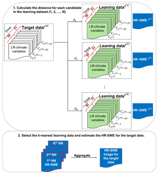
Fatemeh Zakeri, Gregoire Mariethoz, and Manuela Girotto
Hydrol. Earth Syst. Sci., 29, 6935–6958, https://doi.org/10.5194/hess-29-6935-2025, https://doi.org/10.5194/hess-29-6935-2025, 2025
Short summary
Short summary
Our study presents a method to estimate high-resolution snow water equivalent (HR-SWE) using low-resolution climate data (LR-CD). By using a data-driven approach, we analyze historical weather patterns from LR-CD to generate HR-SWE maps. Machine learning and statistical relationships between LR-CD and HR-SWE enable estimation for dates without HR-SWE data. This method enhances water resource management and climate impact assessments, especially in data-scarce regions.
Pau Wiersma, Jan Magnusson, Nadav Peleg, Bettina Schaefli, and Grégoire Mariéthoz
EGUsphere, https://doi.org/10.5194/egusphere-2025-3610, https://doi.org/10.5194/egusphere-2025-3610, 2025
Short summary
Short summary
Using a newly introduced inverse hydrological modeling framework, we demonstrate that streamflow observations have the potential to improve snow mass reconstructions, but that non-uniqueness in the snow-streamflow relationship and uncertainties in the inverse modeling chain can easily stand in the way. We also show that streamflow is most helpful in estimating catchment-aggregated properties of snow mass reconstructions, in particular catchment-aggregated melt rates.
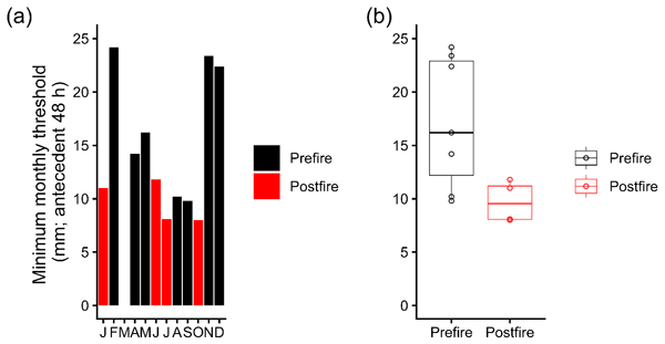
Christina Song, Micheline Campbell, and Andy Baker
Hydrol. Earth Syst. Sci., 29, 4241–4250, https://doi.org/10.5194/hess-29-4241-2025, https://doi.org/10.5194/hess-29-4241-2025, 2025
Short summary
Short summary
Groundwater can be replenished by rainfall that percolates from the surface to the water table. The amount of rainfall that is needed to generate this groundwater recharge is hard to measure. We determined this rainfall amount by identifying recharge events as water percolates from the surface, through a cave. During our monitoring, an intense fire occurred above the cave, and we were able to quantify any change in the amount of rainfall necessary to generate recharge before and after the fire.
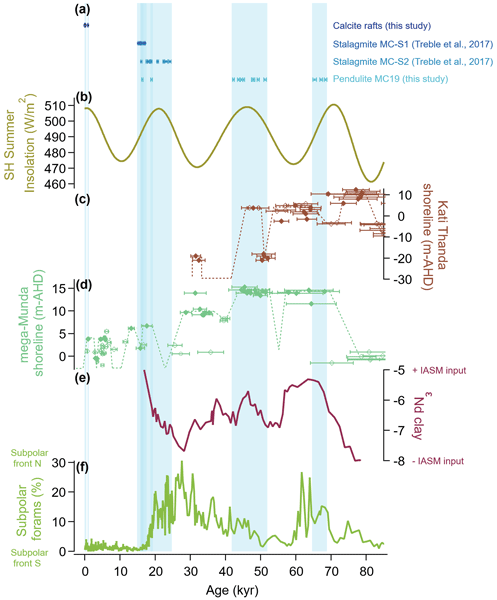
Calla N. Gould-Whaley, Russell N. Drysdale, Pauline C. Treble, Jan-Hendrik May, Stacey C. Priestley, John C. Hellstrom, Christopher R. Vardanega, and Clare C. Buswell
Clim. Past, 21, 857–876, https://doi.org/10.5194/cp-21-857-2025, https://doi.org/10.5194/cp-21-857-2025, 2025
Short summary
Short summary
Climate change is causing enhanced aridity across many regions of the globe, leading to increased reliance on groundwater resources. We need to understand how groundwater recharge behaves in arid regions over long timescales; unfortunately, arid landscapes tend to preserve very little evidence of their climatic past. We present evidence to suggest that carbonate formations that grow in groundwater can be used as archives of past groundwater recharge in Australia's arid zone.
Mathieu Vrac, Denis Allard, Grégoire Mariéthoz, Soulivanh Thao, and Lucas Schmutz
Earth Syst. Dynam., 15, 735–762, https://doi.org/10.5194/esd-15-735-2024, https://doi.org/10.5194/esd-15-735-2024, 2024
Short summary
Short summary
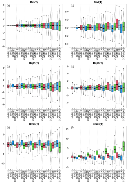
We aim to combine multiple global climate models (GCMs) to enhance the robustness of future projections. We introduce a novel approach, called "α pooling", aggregating the cumulative distribution functions (CDFs) of the models into a CDF more aligned with historical data. The new CDFs allow us to perform bias adjustment of all the raw climate simulations at once. Experiments with European temperature and precipitation demonstrate the superiority of this approach over conventional techniques.
Andy Baker, Margaret Shanafield, Wendy Timms, Martin Sogaard Andersen, Stacey Priestley, and Marilu Melo Zurita
Geosci. Instrum. Method. Data Syst., 13, 117–129, https://doi.org/10.5194/gi-13-117-2024, https://doi.org/10.5194/gi-13-117-2024, 2024
Short summary
Short summary
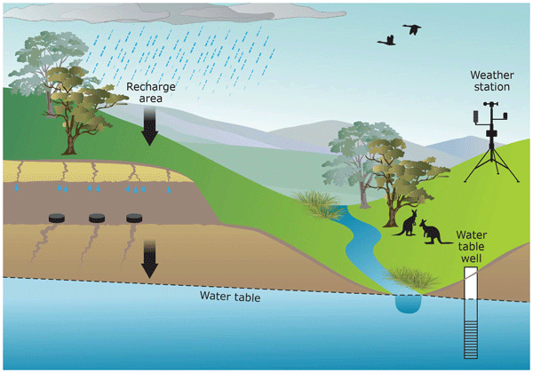
Much of the world relies on groundwater as a water resource, yet it is hard to know when and where rainfall replenishes our groundwater aquifers. Caves, mines, and tunnels that are situated above the groundwater table are unique observatories of water transiting from the land surface to the aquifer. This paper will show how networks of loggers deployed in these underground spaces across Australia have helped understand when, where, and how much rainfall is needed to replenish the groundwater.
Nikita Kaushal, Franziska A. Lechleitner, Micah Wilhelm, Khalil Azennoud, Janica C. Bühler, Kerstin Braun, Yassine Ait Brahim, Andy Baker, Yuval Burstyn, Laia Comas-Bru, Jens Fohlmeister, Yonaton Goldsmith, Sandy P. Harrison, István G. Hatvani, Kira Rehfeld, Magdalena Ritzau, Vanessa Skiba, Heather M. Stoll, József G. Szűcs, Péter Tanos, Pauline C. Treble, Vitor Azevedo, Jonathan L. Baker, Andrea Borsato, Sakonvan Chawchai, Andrea Columbu, Laura Endres, Jun Hu, Zoltán Kern, Alena Kimbrough, Koray Koç, Monika Markowska, Belen Martrat, Syed Masood Ahmad, Carole Nehme, Valdir Felipe Novello, Carlos Pérez-Mejías, Jiaoyang Ruan, Natasha Sekhon, Nitesh Sinha, Carol V. Tadros, Benjamin H. Tiger, Sophie Warken, Annabel Wolf, Haiwei Zhang, and SISAL Working Group members
Earth Syst. Sci. Data, 16, 1933–1963, https://doi.org/10.5194/essd-16-1933-2024, https://doi.org/10.5194/essd-16-1933-2024, 2024
Short summary
Short summary
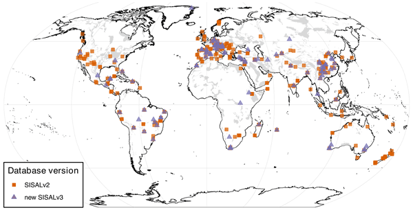
Speleothems are a popular, multi-proxy climate archive that provide regional to global insights into past hydroclimate trends with precise chronologies. We present an update to the SISAL (Speleothem Isotopes
Synthesis and AnaLysis) database, SISALv3, which, for the first time, contains speleothem trace element records, in addition to an update to the stable isotope records available in previous versions of the database, cumulatively providing data from 365 globally distributed sites.
Synthesis and AnaLysis) database, SISALv3, which, for the first time, contains speleothem trace element records, in addition to an update to the stable isotope records available in previous versions of the database, cumulatively providing data from 365 globally distributed sites.
Moctar Dembélé, Mathieu Vrac, Natalie Ceperley, Sander J. Zwart, Josh Larsen, Simon J. Dadson, Grégoire Mariéthoz, and Bettina Schaefli
Proc. IAHS, 385, 121–127, https://doi.org/10.5194/piahs-385-121-2024, https://doi.org/10.5194/piahs-385-121-2024, 2024
Short summary
Short summary
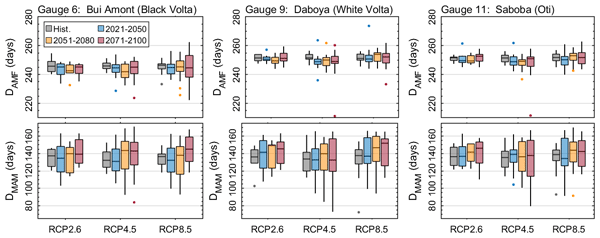
This study assesses the impact of climate change on the timing, seasonality and magnitude of mean annual minimum (MAM) flows and annual maximum flows (AMF) in the Volta River basin (VRB). Several climate change projection data are use to simulate river flow under multiple greenhouse gas emission scenarios. Future projections show that AMF could increase with various magnitude but negligible shift in time across the VRB, while MAM could decrease with up to 14 days of delay in occurrence.
Fabio Oriani, Gregoire Mariethoz, and Manuel Chevalier
Earth Syst. Sci. Data, 16, 731–742, https://doi.org/10.5194/essd-16-731-2024, https://doi.org/10.5194/essd-16-731-2024, 2024
Short summary
Short summary
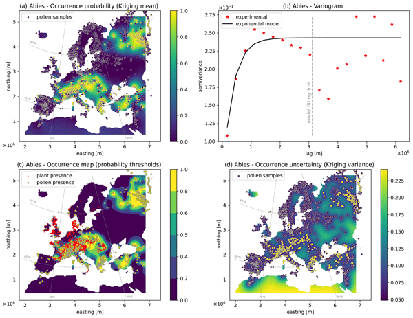
Modern and fossil pollen data contain precious information for reconstructing the climate and environment of the past. However, these data are only achieved for single locations with no continuity in space. We present here a systematic atlas of 194 digital maps containing the spatial estimation of contemporary pollen presence over Europe. This dataset constitutes a free and ready-to-use tool to study climate, biodiversity, and environment in time and space.
Mathieu Gravey and Grégoire Mariethoz
Geosci. Model Dev., 16, 5265–5279, https://doi.org/10.5194/gmd-16-5265-2023, https://doi.org/10.5194/gmd-16-5265-2023, 2023
Short summary
Short summary
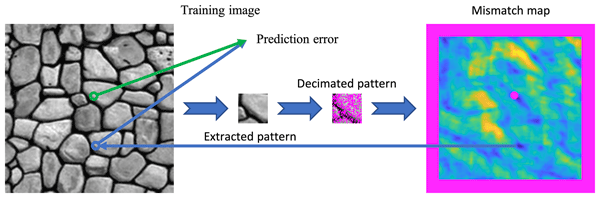
Multiple‐point geostatistics are widely used to simulate complex spatial structures based on a training image. The use of these methods relies on the possibility of finding optimal training images and parametrization of the simulation algorithms. Here, we propose finding an optimal set of parameters using only the training image as input. The main advantage of our approach is to remove the risk of overfitting an objective function.

Nadav Peleg, Herminia Torelló-Sentelles, Grégoire Mariéthoz, Lionel Benoit, João P. Leitão, and Francesco Marra
Nat. Hazards Earth Syst. Sci., 23, 1233–1240, https://doi.org/10.5194/nhess-23-1233-2023, https://doi.org/10.5194/nhess-23-1233-2023, 2023
Short summary
Short summary
Floods in urban areas are one of the most common natural hazards. Due to climate change enhancing extreme rainfall and cities becoming larger and denser, the impacts of these events are expected to increase. A fast and reliable flood warning system should thus be implemented in flood-prone cities to warn the public of upcoming floods. The purpose of this brief communication is to discuss the potential implementation of low-cost acoustic rainfall sensors in short-term flood warning systems.
Moctar Dembélé, Mathieu Vrac, Natalie Ceperley, Sander J. Zwart, Josh Larsen, Simon J. Dadson, Grégoire Mariéthoz, and Bettina Schaefli
Hydrol. Earth Syst. Sci., 26, 1481–1506, https://doi.org/10.5194/hess-26-1481-2022, https://doi.org/10.5194/hess-26-1481-2022, 2022
Short summary
Short summary
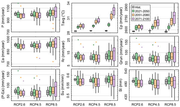
Climate change impacts on water resources in the Volta River basin are investigated under various global warming scenarios. Results reveal contrasting changes in future hydrological processes and water availability, depending on greenhouse gas emission scenarios, with implications for floods and drought occurrence over the 21st century. These findings provide insights for the elaboration of regional adaptation and mitigation strategies for climate change.

Ashley N. Martin, Karina Meredith, Andy Baker, Marc D. Norman, and Eliza Bryan
Hydrol. Earth Syst. Sci., 25, 3837–3853, https://doi.org/10.5194/hess-25-3837-2021, https://doi.org/10.5194/hess-25-3837-2021, 2021
Short summary
Short summary
We measured the silicon isotopic composition of groundwater from Rottnest Island, Western Australia, to investigate water–rock interactions in a coastal aquifer. Silicon isotopic ratios varied spatially across the island and were related to secondary mineral formation and vertical mixing within the aquifer. We find that silicate dissolution occurs in the freshwater–seawater transition zone, supporting the recent recognition of submarine groundwater discharge in the oceanic silicon isotope cycle.
Zhenjiao Jiang, Dirk Mallants, Lei Gao, Tim Munday, Gregoire Mariethoz, and Luk Peeters
Geosci. Model Dev., 14, 3421–3435, https://doi.org/10.5194/gmd-14-3421-2021, https://doi.org/10.5194/gmd-14-3421-2021, 2021
Short summary
Short summary
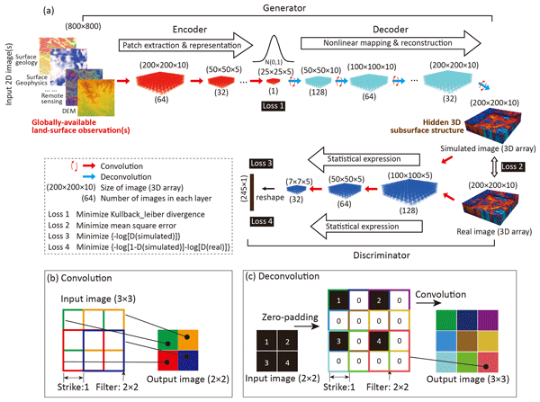
Fast and reliable tools are required to extract hidden information from big geophysical and remote sensing data. A deep-learning model in 3D image construction from 2D image(s) is here developed for paleovalley mapping from globally available digital elevation data. The outstanding performance for 3D subsurface imaging gives confidence that this generic novel tool will make better use of existing geophysical and remote sensing data for improved management of limited earth resources.
Cited articles
Arbel, Y., Greenbaum, N., Lange, J., Shtober-Zisu, N., Grodeck, T.,
Wittenberg, L., and Inbar, M.: Hydrologic classification of cave drips in a
Mediterranean climate, based on hydrograph separation and flow mechanisms,
Israel J. Earth Sci., 57, 291–310, https://doi.org/10.1560/IJES.57.3-4.291, 2008.
Arbel, Y., Greenbaum, N., Lange, J., and Inbar, M.: Infiltration processes
and flow rates in developed karst vadose zone using tracers in cave drips,
Earth Surf. Proc. Land., 35, 1682–1693, https://doi.org/10.1002/esp.2010, 2010.
Atkinson, T. C.: Diffuse flow and conduit flow in limestone terrain in the
Mendip Hills, Somerset (Great Britain), J. Hydrol., 35, 93–110,
https://doi.org/10.1016/0022-1694(77)90079-8, 1977.
Bakalowicz, M. J. and Jusserand, C.: Etude de l'infiltration en milieu
karstique par les methodes geochemiques et isotopiques Cas de la Grotte de
Niaux, Bulletin du Centre d'Hydrogeologie, 1987, 265–283, 1987.
Baker, A. and Brunsdon, C.: Non-linearities in drip water hydrology: an
example from Stump Cross Caverns, Yorkshire, J. Hydrol., 277, 151–163,
https://doi.org/10.1016/S0022-1694(03)00063-5, 2003.
Baker, A., Genty, D., and Fairchild, I. J.: Hydrological characterisation of
stalagmite dripwaters at Grotte de Villars, Dordogne, by the analysis of
inorganic species and luminescent organic matter, Hydrol. Earth Syst. Sci.,
4, 439–449, https://doi.org/10.5194/hess-4-439-2000, 2000.
Bates, B., Hope, P., Ryan, B., Smith, I., and Charles, S.: Key findings from
the Indian Ocean Climate Initiative and their impact on policy development in
Australia, Climatic Change, 89, 339–354, https://doi.org/10.1007/s10584-007-9390-9,
2008.
Blondel, T., Emblanch, C., Dudal, Y., Batiot-Guilhe, C., Travi, Y., and
Gaffet, S.: Transit Time Environmental Tracing from Dissolved Organic Matter
Fluorescence Properties in Karstic Aquifers. Application to Different Flows
of Fontaine de Vaucluse Experimental Basin (SE France), Advances in Research
in Karst Media, 1, 143–149, https://doi.org/10.1007/978-3-642-12486-0_22, 2010.
BoM: Climate Data Online (Station 9547), Bureau of Meteorology Melbourne,
available at: http://www.bom.gov.au/climate/data/ (last access:
26 August 2014), 2015.
Bosse, M., Zlot, R., and Flick, P.: Zebedee: Design of a Spring-Mounted 3-D
Range Sensor with Application to Mobile Mapping, IEEE T. Robotics, 28,
1104–1119, https://doi.org/10.1109/TRO.2012.2200990, 2012.
Bottrell, S. H. and Atkinson, T. C.: Tracer study of flow and storage in the
unsaturated zone of a karstic limestone aquifer, Tracer Hydrology, edited by:
Hotzl, H. and Werner, A., Aa Balkema, Rotterdam, 207–211, 1992.
Carrasco, F., Andreo, B., Liñán, C., and Mudry, J.: Contribution of
stable isotopes to the understanding of the unsaturated zone of a carbonate
aquifer (Nerja Cave, southern Spain), C. R. Geosci., 338, 1203–1212,
https://doi.org/10.1016/j.crte.2006.09.009, 2006.
Collister, C. and Mattey, D.: Controls on water drop volume at speleothem
drip sites: An experimental study, J. Hydrol., 358, 259–267,
https://doi.org/10.1016/j.jhydrol.2008.06.008, 2008.
Cuthbert, M. O., Baker, A., Jex, C. N., Graham, P. W., Treble, P. C.,
Andersen, M. S., and Ian Acworth, R.: Drip water isotopes in semi-arid karst:
Implications for speleothem paleoclimatology, Earth Planet. Sc. Lett., 395,
194–204, https://doi.org/10.1016/j.epsl.2014.03.034, 2014.
Dahan, O., Shani, Y., Enzel, Y., Yechieli, Y., and Yakirevich, A.: Direct
measurements of floodwater infiltration into shallow alluvial aquifers, J.
Hydrol., 344, 157–170, https://doi.org/10.1016/j.jhydrol.2007.06.033, 2007.
Even, H., Carmi, I., Magaritz, M., and Gerson, R.: Timing the transport of
water through the upper vadose zone in a Karstic system above a cave in
Israel, Earth Surf. Proc. Land., 11, 181–191, https://doi.org/10.1002/esp.3290110208,
1986.
Fabuel-Perez, I., Hodgetts, D., and Redfern, J.: A new approach for outcrop
characterization and geostatistical analysis of a low-sinuosity
fluvial-dominated succession using digital outcrop models: Upper Triassic
Oukaimeden Sandstone Formation, central High Atlas, Morocco, AAPG Bulletin,
93, 795–827, 2009.
Fairchild, I. J. and Baker, A.: Speleothem Science: From Process to Past
Environments, Wiley-Blackwell, 450 pp., 2012.
Fischer, M. J. and Treble, P. C.: Calibrating climate-δ18O
regression models for the interpretation of high-resolution speleothem
δ18O time series, J. Geophys. Res.-Atmos., 113, D17103,
https://doi.org/10.1029/2007jd009694, 2008.
Ford, D. and Williams, P.: Karst Hydrogeology and Geomorphology, Wiley,
576 pp., 2007.
Friederich, H. and Smart, P. L.: The classification of autogenic percolation
waters in karst aquifers: A study in G.B. cave, Mendip Hills, England,
Proceedings of the University of Bristol Speleological Society, 1982,
143–159, 1982.
Genty, D. and Deflandre, G.: Drip flow variations under a stalactite of the
Pere Noel cave (Belgium). Evidence of seasonal variations and air pressure
constraints, J. Hydrol., 211, 208–232, 1998.
Ghasemizadeh, R., Hellweger, F., Butscher, C., Padilla, I., Vesper, D.,
Field, M., and Alshawabkeh, A.: Review: Groundwater flow and transport
modeling of karst aquifers, with particular reference to the North Coast
Limestone aquifer system of Puerto Rico, Hydrogeol. J., 20, 1441–1461,
https://doi.org/10.1007/s10040-012-0897-4, 2012.
Goldscheider, N. and Drew, D.: Methods in Karst Hydrogeology, Taylor &
Francis, London, 264 pp., 2007.
Hyyppa, J., Kelle, O., Lehikoinen, M., and Inkinen, M.: A segmentation-based
method to retrieve stem volume estimates from 3-D tree height models produced
by laser scanners, IEEE T. Geosci. Remote, 39, 969–975,
https://doi.org/10.1109/36.921414, 2001.
Jex, C. N., Mariethoz, G., Baker, A., Graham, P., Andersen, M., Acworth, I.,
Edwards, N., and Azcurra, C.: Spatially dense drip hydrological monitoring
and infiltration behaviour at the Wellington Caves, South East Australia,
Int. J. Speleol., 41, 283–296, 2012.
Kaul, L., Zlot, R., and Bosse, M.: Continuous-Time Three-Dimensional Mapping
for Micro Aerial Vehicles with a Passively Actuated Rotating Laser Scanner,
J. Field Robot., 33, 103–132, https://doi.org/10.1002/rob.21614, 2016.
Kogovšek, J.: Water tracer tests in the vadose zone, Tracer Hydrology,
Balkema, Rotterdam, 1997.
Koons, R. D. and Helmke, P. A.: Neutron Activation Analysis of Standard
Soils, Soil Sci. Soc. Am. J., 42, 237–240,
https://doi.org/10.2136/sssaj1978.03615995004200020004x, 1978.
Mahmud, K., Mariethoz, G., Treble, P., and Baker, A.: Terrestrial Lidar
Survey and Morphological Analysis to Identify Infiltration Properties in the
Tamala Limestone, Western Australia, Selected Topics in Applied Earth
Observations and Remote Sensing, IEEE Journal of, PP, 1–12,
10.1109/JSTARS.2015.2451088, 2015.
Markowska, M., Baker, A., Treble, P. C., Andersen, M. S., Hankin, S., Jex, C.
N., Tadros, C. V., and Roach, R.: Unsaturated zone hydrology and cave drip
discharge water response: Implications for speleothem paleoclimate record
variability, J. Hydrol., 529, 662–675, https://doi.org/10.1016/j.jhydrol.2014.12.044,
2015.
McDonald, J. and Drysdale, R.: Hydrology of cave drip waters at varying
bedrock depths from a karst system in southeastern Australia, Hydrol.
Process., 21, 1737–1748, https://doi.org/10.1002/hyp.6356, 2007.
Morales, T., Fdez. de
Valderrama, I., Uriarte, J. A., Antigüedad, I., and Olazar, M.:
Predicting travel times and transport characterization in karst conduits by
analyzing tracer-breakthrough curves, J. Hydrol., 334, 183–198,
https://doi.org/10.1016/j.jhydrol.2006.10.006, 2007.
Morales, T., Uriarte, J. A., Olazar, M., Antigüedad, I., and Angulo, B.:
Solute transport modelling in karst conduits with slow zones during different
hydrologic conditions, J. Hydrol., 390, 182–189,
https://doi.org/10.1016/j.jhydrol.2010.06.041, 2010.
Mudry, J., Andreo, B., Charmoille, A., Liñán, C., and Carrasco, F.:
Some applications of geochemical and isotopic techniques to hydrogeology of
the caves after research in two sites (Nerja Cave-S Spain and Fourbanne
system-French Jura), Int. J. Speleol., 37, 67–74, 2008.
Pardo-Iguzquiza, E., Durán-Valsero, J. J., and Rodríguez-Galiano, V.:
Morphometric analysis of three-dimensional networks of karst conduits,
Geomorphology, 132, 17–28, https://doi.org/10.1016/j.geomorph.2011.04.030, 2011.
Pringle, J. K., Howell, J. A., Hodgetts, D., Westerman, A. R., and Hodgson,
D. M.: Virtual outcrop models of petroleum reservoir analogues: a review of
the current state of-the-art, First Break, 24, 33–42, 2006.
Raesi, E. and Karami, G.: Hydrochemographs of Berghan Karst Springs as
indicators of aquifer characteristics, J. Cave Karst Stud., 59, 112–118,
1997.
Raupach, M. R., Briggs, P. R., Haverd, V., King, E. A., Paget, M., and
Trudinger, C. M.: Australian Water Availability Project (AWAP): CSIRO Marine
and Atmospheric Research Component: Final Report for Phase, 3, 67, 2009.
Rimon, Y., Dahan, O., Nativ, R., and Geyer, S.: Water percolation through the
deep vadose zone and groundwater recharge: Preliminary results based on a new
vadose zone monitoring system, Water Resour. Res., 43, W05402,
https://doi.org/10.1029/2006wr004855, 2007.
Rotevatn, A., Buckley, S. J., Howell, J. A., and Fossen, H.: Overlapping
faults and their effect on fluid flow in different reservoir types: A
LIDAR-based outcrop modeling and flow simulation study, AAPG Bulletin, 93,
407–427, 2009.
Scanlon, B. R.: Evaluation of Methods of Estimating Recharge in Semiarid and
Arid Regions in the Southwestern U.S., in: Groundwater Recharge in a Desert
Environment: The Southwestern United States, American Geophysical Union,
235–254, 2013.
Sheffer, N. A., Cohen, M., Morin, E., Grodek, T., Gimburg, A., Magal, E.,
Gvirtzman, H., Nied, M., Isele, D., and Frumkin, A.: Integrated cave drip
monitoring for epikarst recharge estimation in a dry Mediterranean area, Sif
Cave, Israel, Hydrol. Process., 25, 2837–2845, https://doi.org/10.1002/hyp.8046, 2011.
Smith, A. J., Massuel, S., and Pollock, D. W.: Geohydrology of the Tamala
Limestone Formation in the Perth Region: Origin and Role of Secondary
Porosity, 63, 2012.
Sophocleous, M. A.: Combining the soilwater balance and water-level
fluctuation methods to estimate natural groundwater recharge: Practical
aspects, J. Hydrol., 124, 229–241, https://doi.org/10.1016/0022-1694(91)90016-B, 1991.
Tooth, A. F. and Fairchild, I. J.: Soil and karst aquifer hydrological
controls on the geochemical evolution of speleothem-forming drip waters, Crag
Cave, southwest Ireland, J. Hydrol., 273, 51–68,
https://doi.org/10.1016/S0022-1694(02)00349-9, 2003.
Treble, P. C., Bradley, C., Wood, A., Baker, A., Jex, C. N., Fairchild, I.
J., Gagan, M. K., Cowley, J., and Azcurra, C.: An isotopic and modelling
study of flow paths and storage in Quaternary calcarenite, SW Australia:
implications for speleothem paleoclimate records, Quaternary Sci. Rev., 64,
90–103, https://doi.org/10.1016/j.quascirev.2012.12.015, 2013.
Treble, P. C., Fairchild, I. J., Griffiths, A., Baker, A., Meredith, K. T.,
Wood, A., and McGuire, E.: Impacts of cave air ventilation and in-cave prior
calcite precipitation on Golgotha Cave dripwater chemistry, southwest
Australia, Quaternary Sci. Rev., 127, 61–72,
https://doi.org/10.1016/j.quascirev.2015.06.001, 2015.
White, W. B.: Karst hydrology: recent developments and open questions, Eng.
Geol., 65, 85–105, https://doi.org/10.1016/S0013-7952(01)00116-8, 2002.
Williams, P. W.: The role of the subcutaneous zone in karst hydrology, J.
Hydrol., 61, 45–67, https://doi.org/10.1016/0022-1694(83)90234-2, 1983.
Wilson, P., Hodgetts, D., Rarity, F., Gawthorpe, R. L., and Sharp, I. R.:
Structural geology and 4D evolution of a half-graben: New digital outcrop
modelling techniques applied to the Nukhul half-graben, Suez rift, Egypt, J.
Struct. Geol., 31, 328–345, https://doi.org/10.1016/j.jsg.2008.11.013, 2009.
Worthington, S. R. H. and Gunn, J.: Hydrogeology of Carbonate Aquifers: A
Short History, Ground Water, 47, 462–467,
https://doi.org/10.1111/j.1745-6584.2008.00548.x, 2009.
Zlot, R. and Bosse, M.: Efficient Large-scale Three-dimensional Mobile
Mapping for Underground Mines, J. Field Robot., 31, 758–779, 2014a.
Zlot, R. and Bosse, M.: Three-Dimensional Mobile Mapping of Caves, Journal of
Cave and Karst Studies, 76, 191–206, https://doi.org/10.4311/2012EX0287, 2014b.
Short summary
Caves offer a natural inception point to observe both the long-term groundwater recharge and the preferential movement of water through the unsaturated zone of such limestone. In this study, we develop a method that combines automated drip rate logging systems and remote sensing techniques to quantify the infiltration processes within a cave.
Caves offer a natural inception point to observe both the long-term groundwater recharge and the...


