
Articles | Volume 18, issue 3
https://doi.org/10.5194/hess-18-1199-2014
© Author(s) 2014. This work is distributed under
the Creative Commons Attribution 3.0 License.
the Creative Commons Attribution 3.0 License.
https://doi.org/10.5194/hess-18-1199-2014
© Author(s) 2014. This work is distributed under
the Creative Commons Attribution 3.0 License.
the Creative Commons Attribution 3.0 License.
Research article
| 
28 Mar 2014
Research article |
| 28 Mar 2014
A physically based approach for the estimation of root-zone soil moisture from surface measurements
S. Manfreda
School of Engineering, University of Basilicata, Potenza, Italy
L. Brocca
Research Institute for Geo-Hydrological Protection (IRPI), National Research Council, Perugia, Italy
T. Moramarco
Research Institute for Geo-Hydrological Protection (IRPI), National Research Council, Perugia, Italy
F. Melone
Research Institute for Geo-Hydrological Protection (IRPI), National Research Council, Perugia, Italy
J. Sheffield
Department of Civil and Environmental Engineering, Princeton University, Princeton, NJ, USA
Related authors
Domenico Miglino, Seifeddine Jomaa, Michael Rode, Khim Cathleen Saddi, Francesco Isgrò, and Salvatore Manfreda
Hydrol. Earth Syst. Sci., 29, 4133–4151, https://doi.org/10.5194/hess-29-4133-2025, https://doi.org/10.5194/hess-29-4133-2025, 2025
Short summary
Short summary
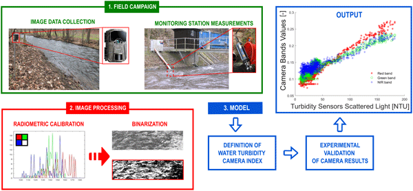
Turbidity is a key factor for water quality monitoring. Here, an image-based procedure is tested in a full-scale river monitoring experiment using digital cameras. This approach can enhance our understanding of the real-time status of waterbodies, overcoming the spatial and temporal resolution limitations of existing methods. It also facilitates early-warning systems, advances water research through increased data availability and reduces operating costs.
Paolo Nasta, Günter Blöschl, Heye R. Bogena, Steffen Zacharias, Roland Baatz, Gabriëlle De Lannoy, Karsten H. Jensen, Salvatore Manfreda, Laurent Pfister, Ana M. Tarquis, Ilja van Meerveld, Marc Voltz, Yijian Zeng, William Kustas, Xin Li, Harry Vereecken, and Nunzio Romano
Hydrol. Earth Syst. Sci., 29, 465–483, https://doi.org/10.5194/hess-29-465-2025, https://doi.org/10.5194/hess-29-465-2025, 2025
Short summary
Short summary
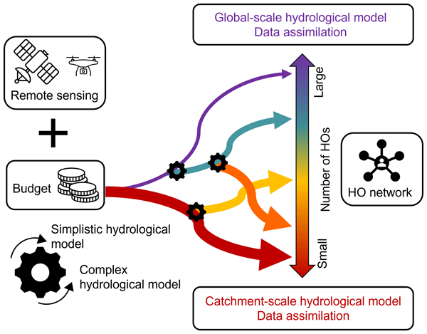
The Unsolved Problems in Hydrology (UPH) initiative has emphasized the need to establish networks of multi-decadal hydrological observatories to tackle catchment-scale challenges on a global scale. This opinion paper provocatively discusses two endmembers of possible future hydrological observatory (HO) networks for a given hypothesized community budget: a comprehensive set of moderately instrumented observatories or, alternatively, a small number of highly instrumented supersites.
Qianqian Han, Yijian Zeng, Lijie Zhang, Calimanut-Ionut Cira, Egor Prikaziuk, Ting Duan, Chao Wang, Brigitta Szabó, Salvatore Manfreda, Ruodan Zhuang, and Bob Su
Geosci. Model Dev., 16, 5825–5845, https://doi.org/10.5194/gmd-16-5825-2023, https://doi.org/10.5194/gmd-16-5825-2023, 2023
Short summary
Short summary
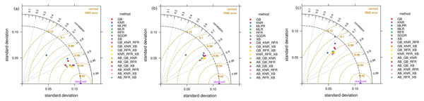
Using machine learning, we estimated global surface soil moisture (SSM) to aid in understanding water, energy, and carbon exchange. Ensemble models outperformed individual algorithms in predicting SSM under different climates. The best-performing ensemble included K-neighbours Regressor, Random Forest Regressor, and Extreme Gradient Boosting. This is important for hydrological and climatological applications such as water cycle monitoring, irrigation management, and crop yield prediction.
Robert Ljubičić, Dariia Strelnikova, Matthew T. Perks, Anette Eltner, Salvador Peña-Haro, Alonso Pizarro, Silvano Fortunato Dal Sasso, Ulf Scherling, Pietro Vuono, and Salvatore Manfreda
Hydrol. Earth Syst. Sci., 25, 5105–5132, https://doi.org/10.5194/hess-25-5105-2021, https://doi.org/10.5194/hess-25-5105-2021, 2021
Short summary
Short summary
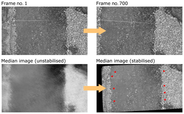
The rise of new technologies such as drones (unmanned aerial systems – UASs) has allowed widespread use of image velocimetry techniques in place of more traditional, usually slower, methods during hydrometric campaigns. In order to minimize the velocity estimation errors, one must stabilise the acquired videos. In this research, we compare the performance of different UAS video stabilisation tools and provide guidelines for their use in videos with different flight and ground conditions.
Esmaeel Adrah, Luca Brocca, Emine Senkardesler, and He Yin
Earth Syst. Sci. Data Discuss., https://doi.org/10.5194/essd-2026-603, https://doi.org/10.5194/essd-2026-603, 2026
Preprint under review for ESSD
Short summary
Short summary
The eastern Mediterranean is a hotspot for drought, extreme water scarcity, and geopolitical tension, yet long-term data on irrigation is missing. To address this, we used twenty-six years of satellite imagery to track soil moisture and map winter and summer irrigated lands. This freely available data reveals irrigation changes across the region over time, and support managing scarce water resources, understanding climate impacts, and improving regional food security.
Julia Pfeffer, Benoît Meyssignac, Rory Bingham, Alejandro Blazquez, Marie Bouih, Carla Braitenberg, Luca Brocca, Henryk Dobslaw, Ramiro Ferrari, Ehsan Forootan, Helena Gerdener, Muhammad Tahir Javed, Laura Jensen, Volker Klemann, Anna Kremer, Jürgen Kusche, Gilles Larnicol, Muhammad Usman Liaqat, Francesco Leopardi, Elisavet-Maria Mamagiannou, Gerardo Maurizio, Roland Pail, Isabelle Panet, Thomas Papanikolaou, Peyman Saemian, Ingo Sasgen, Maike Schumacher, Marius Schlaak, Linus Shihora, Alireza Sobouti, Nico Sneeuw, Mohammad Javad Tourian, Dimitrios Tsoulis, Georgios Vergos, Bert Wouters, Fan Yang, and Ilias Daras
EGUsphere, https://doi.org/10.5194/egusphere-2026-4642, https://doi.org/10.5194/egusphere-2026-4642, 2026
This preprint is open for discussion and under review for Earth Observation (EO).
Short summary
Short summary
The ESA SING project demonstrates how the future satellite gravity missions NGGM and MAGIC will improve observations of continental water storage, oceans, glaciers, sea level, earthquakes, and climate change. Their more accurate, higher-resolution gravity measurements will enhance Earth system monitoring, improve climate and hazard assessments, and strengthen operational services for water management, disaster preparedness, and environmental decision-making.
Muhammad Usman Liaqat, Stefania Camici, Francesco Leopardi, Jaime Gaona, and Luca Brocca
Hydrol. Earth Syst. Sci., 30, 4969–4983, https://doi.org/10.5194/hess-30-4969-2026, https://doi.org/10.5194/hess-30-4969-2026, 2026
Short summary
Short summary
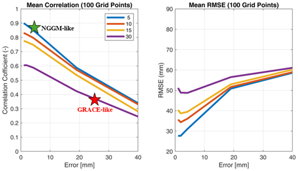
Tracking land water storage helps examine extreme events and manage water resources. GRACE (Gravity Recovery and Climate Experiment) missions observe changes, but coarse resolution in space and time challenges effective management. New gravity mission called MAGIC (Mass Change And Geosciences International Constellation) can offers better accuracy. This study tested MAGIC’s potential to estimate precipitation using the SM2RAIN approach. Results show SM2RAIN works well with frequent, accurate data but deteriorates with noisy/sparse data, emphasizing the need for precise gravity missions.
Pierre Laluet, Jacopo Dari, Louise Busschaert, Zdenko Heyvaert, Gabrielle De Lannoy, Pia Langhans, Sara Modanesi, Christian Massari, Luca Brocca, Carla Saltalippi, Renato Morbidelli, Clément Albergel, and Wouter Dorigo
Earth Syst. Sci. Data, 18, 4833–4853, https://doi.org/10.5194/essd-18-4833-2026, https://doi.org/10.5194/essd-18-4833-2026, 2026
Short summary
Short summary
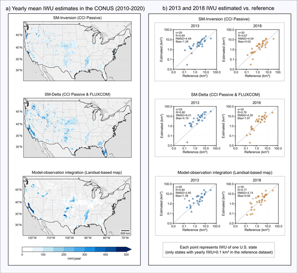
We developed a long-term dataset collection of irrigation water use based on about two decades of satellite observations, three distinct approaches, and many input datasets. The collection provides monthly estimates for major agricultural regions and helps describe how irrigation varies across locations, seasons, and years. It offers a foundation for improving how irrigation is quantified, compared across methods, and integrated into large-scale hydrological and climate studies.
Francesco Avanzi, Hans Lievens, Michael Matiu, Paolo Filippucci, Oscar M. Baez Villanueva, Simone Gabellani, Fabio Delogu, Lorenzo Alfieri, Andrea Libertino, Pere Quintana-Seguì, Diego G. Miralles, Luca Brocca, Christian Massari, and Gabriëlle J. M. De Lannoy
EGUsphere, https://doi.org/10.5194/egusphere-2026-2851, https://doi.org/10.5194/egusphere-2026-2851, 2026
Short summary
Short summary
We developed a new system to map and monitor snow and stored water across large mountain regions using satellite data and computer simulations. Tested in four major European river basins, the system reproduced snow conditions with high accuracy and realistically captured how snow changes with elevation. Because it does not rely on ground measurements, it can help provide consistent information on snow-water resources worldwide, supporting water management and climate adaptation.
Ather Abbas, Yuan Yang, Ming Pan, Yves Tramblay, Chaopeng Shen, Haoyu Ji, Solomon H. Gebrechorkos, Florian Pappenberger, JongCheol Pyo, Dapeng Feng, George Huffman, Phu Nguyen, Christian Massari, Luca Brocca, Jackson Tan, and Hylke E. Beck
Hydrol. Earth Syst. Sci., 30, 3399–3423, https://doi.org/10.5194/hess-30-3399-2026, https://doi.org/10.5194/hess-30-3399-2026, 2026
Short summary
Short summary
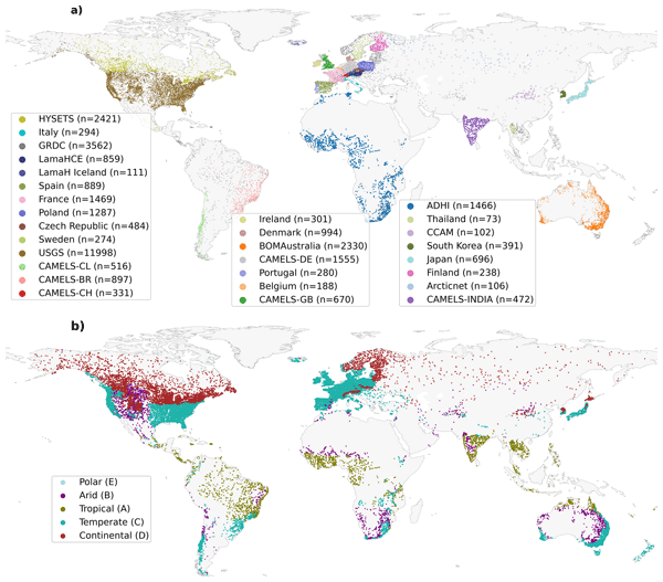
Our study evaluated 24 precipitation datasets using a hydrological model at global scale to assess their suitability and accuracy. We found that MSWEP (Multi-Source Weighted-Ensemble Precipitation) V2.8 excels due to its ability to integrate data from multiple sources, while others, such as IMERG (Integrated Multi-satellitE Retrievals for Global Precipitation Mission) and GDAS (Global Data Assimilation System), demonstrated strong regional performances. This research assists in selecting the appropriate dataset for applications in water resource management, hazard assessment, agriculture, and environmental monitoring.
Peyman Afrasiabikia, Atefeh Parvaresh Rizi, and Luca Brocca
ISPRS Ann. Photogramm. Remote Sens. Spatial Inf. Sci., X-4-W8-2025, 33–38, https://doi.org/10.5194/isprs-annals-X-4-W8-2025-33-2026, https://doi.org/10.5194/isprs-annals-X-4-W8-2025-33-2026, 2026
Ehsan Modiri, Oldrich Rakovec, Pallav Kumar Shrestha, Almudena García-García, Leandro Avila, Katie Blackford, Elizabeth Cooper, Bram Droppers, Paolo Filippucci, Milan Fischer, Matěj Orság, Pietro Stradiotti, Luca Brocca, Douglas B. Clark, Wouter Dorigo, Stefan Kollet, Jian Peng, Niko Wanders, and Luis Samaniego
EGUsphere, https://doi.org/10.5194/egusphere-2026-1012, https://doi.org/10.5194/egusphere-2026-1012, 2026
Short summary
Short summary
Drought impacts water supply, agriculture, and ecosystems, yet hydrological models often disagree on when and where drought occurs. This study tested whether satellite observations can improve how models represent soil moisture drought in the Rhine River basin. Using several models and major drought events, we show that satellite data improve spatial realism and reveal important differences among models, helping to better understand uncertainty in drought monitoring and early warning.
Paolo Filippucci, Luca Brocca, Luca Ciabatta, Hamidreza Mosaffa, Francesco Avanzi, and Christian Massari
Earth Syst. Sci. Data, 17, 5221–5258, https://doi.org/10.5194/essd-17-5221-2025, https://doi.org/10.5194/essd-17-5221-2025, 2025
Short summary
Short summary
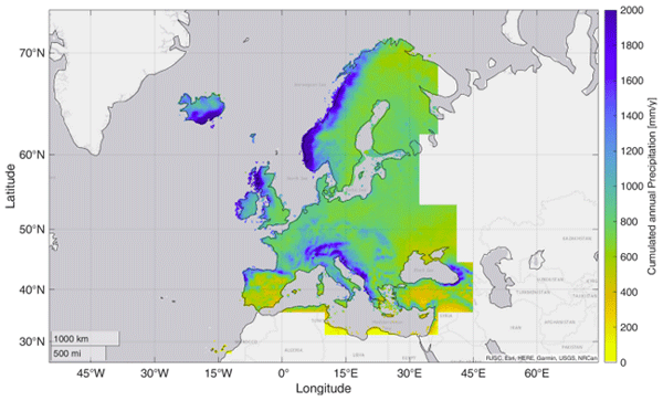
Accurate rainfall data is essential, yet measuring daily precipitation worldwide is challenging. This research presents HYdroclimatic PERformance-enhanced Precipitation (HYPER-P), a dataset combining satellite, ground, and reanalysis data to estimate precipitation at a 1 km scale from 2000 to 2022. HYPER-P improves accuracy, especially in areas with few rain gauges. This dataset supports scientists and decision-makers in understanding and managing water resources more effectively.
Domenico Miglino, Seifeddine Jomaa, Michael Rode, Khim Cathleen Saddi, Francesco Isgrò, and Salvatore Manfreda
Hydrol. Earth Syst. Sci., 29, 4133–4151, https://doi.org/10.5194/hess-29-4133-2025, https://doi.org/10.5194/hess-29-4133-2025, 2025
Short summary
Short summary
Turbidity is a key factor for water quality monitoring. Here, an image-based procedure is tested in a full-scale river monitoring experiment using digital cameras. This approach can enhance our understanding of the real-time status of waterbodies, overcoming the spatial and temporal resolution limitations of existing methods. It also facilitates early-warning systems, advances water research through increased data availability and reduces operating costs.
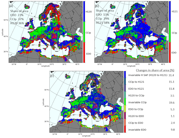
Jaime Gaona, Davide Bavera, Guido Fioravanti, Sebastian Hahn, Pietro Stradiotti, Paolo Filippucci, Stefania Camici, Luca Ciabatta, Hamidreza Mosaffa, Silvia Puca, Nicoletta Roberto, and Luca Brocca
Hydrol. Earth Syst. Sci., 29, 3865–3888, https://doi.org/10.5194/hess-29-3865-2025, https://doi.org/10.5194/hess-29-3865-2025, 2025
Short summary
Short summary
Soil moisture is crucial for the water cycle since it is at the front line of drought. Satellite, model and in situ data help identify soil moisture stress but are challenged by data uncertainties. This study evaluates trends and data coherence of common active/passive microwave sensors and model-based soil moisture data against in situ stations across Europe from 2007 to 2022. Data reliability is increasing, but combining data types improves soil moisture monitoring capabilities.
Stephen E. Darby, Ivan D. Haigh, Melissa Wood, Bui Duong, Tien Le Thuy Du, Thao Phuong Bui, Justin Sheffield, Hal Voepel, and Joël J.-M. Hirschi
EGUsphere, https://doi.org/10.5194/egusphere-2025-3506, https://doi.org/10.5194/egusphere-2025-3506, 2025
Short summary
Short summary
We use model simulations to see what changes have been occurring to Mekong and Red River flows, 1970–2019, due to changes in tropical cyclone (TC)-linked precipitation. Results suggest that the highest river flows in multiple sub-catchments have been increasing over time, with coastal zones most intensely affected due to the combination of TC track and wet soils from prior rainfall. Climate change may exacerbate this TC-linked risk in the future making it a topic of strategic importance.
Paolo Nasta, Günter Blöschl, Heye R. Bogena, Steffen Zacharias, Roland Baatz, Gabriëlle De Lannoy, Karsten H. Jensen, Salvatore Manfreda, Laurent Pfister, Ana M. Tarquis, Ilja van Meerveld, Marc Voltz, Yijian Zeng, William Kustas, Xin Li, Harry Vereecken, and Nunzio Romano
Hydrol. Earth Syst. Sci., 29, 465–483, https://doi.org/10.5194/hess-29-465-2025, https://doi.org/10.5194/hess-29-465-2025, 2025
Short summary
Short summary
The Unsolved Problems in Hydrology (UPH) initiative has emphasized the need to establish networks of multi-decadal hydrological observatories to tackle catchment-scale challenges on a global scale. This opinion paper provocatively discusses two endmembers of possible future hydrological observatory (HO) networks for a given hypothesized community budget: a comprehensive set of moderately instrumented observatories or, alternatively, a small number of highly instrumented supersites.
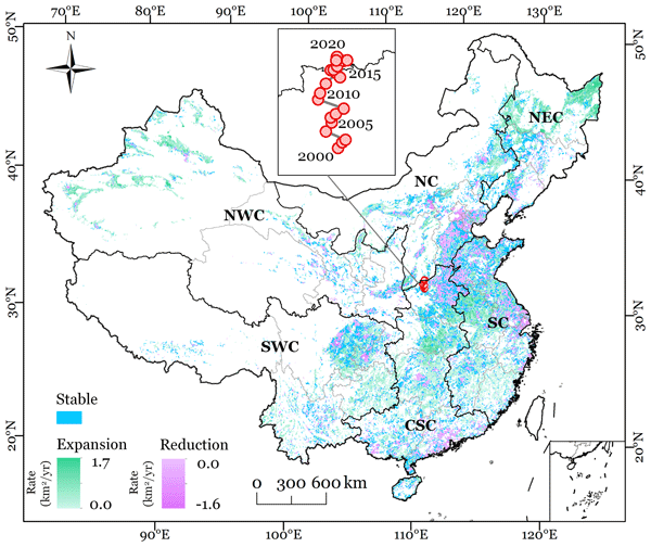
Ling Zhang, Yanhua Xie, Xiufang Zhu, Qimin Ma, and Luca Brocca
Earth Syst. Sci. Data, 16, 5207–5226, https://doi.org/10.5194/essd-16-5207-2024, https://doi.org/10.5194/essd-16-5207-2024, 2024
Short summary
Short summary
This study presented new annual maps of irrigated cropland in China from 2000 to 2020 (CIrrMap250). These maps were developed by integrating remote sensing data, irrigation statistics and surveys, and an irrigation suitability map. CIrrMap250 achieved high accuracy and outperformed currently available products. The new irrigation maps revealed a clear expansion of China’s irrigation area, with the majority (61%) occurring in the water-unsustainable regions facing severe to extreme water stress.
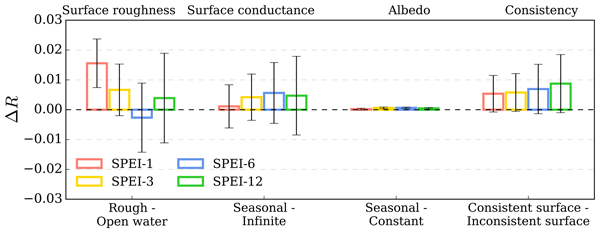
Liqing Peng, Justin Sheffield, Zhongwang Wei, Michael Ek, and Eric F. Wood
Earth Syst. Dynam., 15, 1277–1300, https://doi.org/10.5194/esd-15-1277-2024, https://doi.org/10.5194/esd-15-1277-2024, 2024
Short summary
Short summary
Integrating evaporative demand into drought indicators is effective, but the choice of method and the effectiveness of surface features remain undocumented. We evaluate various methods and surface features for predicting soil moisture dynamics. Using minimal ancillary information alongside meteorological and vegetation data, we develop a simple land-cover-based method that improves soil moisture drought predictions, especially in forests, showing promise for better real-time drought forecasting.
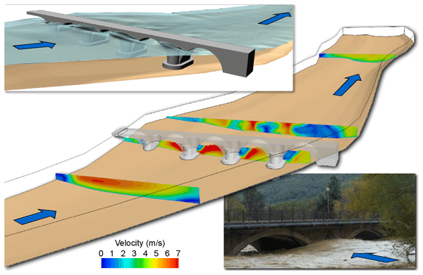
Farhad Bahmanpouri, Tommaso Lazzarin, Silvia Barbetta, Tommaso Moramarco, and Daniele P. Viero
Hydrol. Earth Syst. Sci., 28, 3717–3737, https://doi.org/10.5194/hess-28-3717-2024, https://doi.org/10.5194/hess-28-3717-2024, 2024
Short summary
Short summary
The entropy model is a reliable tool to estimate flood discharge in rivers using observed level and surface velocity. Often, level and velocity sensors are placed on bridges, which may disturb the flow. Using accurate numerical models, we explored the entropy model reliability nearby a multi-arch bridge. We found that it is better to place sensors and to estimate the discharge upstream of bridges; downstream, the entropy model needs the river-wide distribution of surface velocity as input data.
Solomon H. Gebrechorkos, Julian Leyland, Simon J. Dadson, Sagy Cohen, Louise Slater, Michel Wortmann, Philip J. Ashworth, Georgina L. Bennett, Richard Boothroyd, Hannah Cloke, Pauline Delorme, Helen Griffith, Richard Hardy, Laurence Hawker, Stuart McLelland, Jeffrey Neal, Andrew Nicholas, Andrew J. Tatem, Ellie Vahidi, Yinxue Liu, Justin Sheffield, Daniel R. Parsons, and Stephen E. Darby
Hydrol. Earth Syst. Sci., 28, 3099–3118, https://doi.org/10.5194/hess-28-3099-2024, https://doi.org/10.5194/hess-28-3099-2024, 2024
Short summary
Short summary
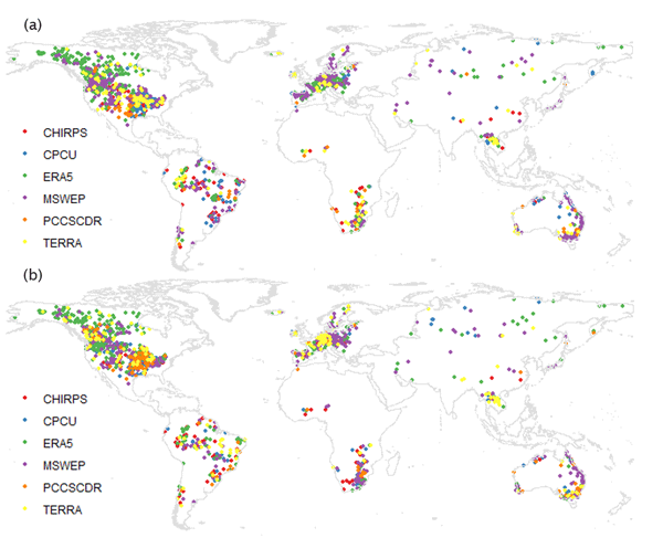
This study evaluated six high-resolution global precipitation datasets for hydrological modelling. MSWEP and ERA5 showed better performance, but spatial variability was high. The findings highlight the importance of careful dataset selection for river discharge modelling due to the lack of a universally superior dataset. Further improvements in global precipitation data products are needed.
Jacopo Dari, Paolo Filippucci, and Luca Brocca
Hydrol. Earth Syst. Sci., 28, 2651–2659, https://doi.org/10.5194/hess-28-2651-2024, https://doi.org/10.5194/hess-28-2651-2024, 2024
Short summary
Short summary
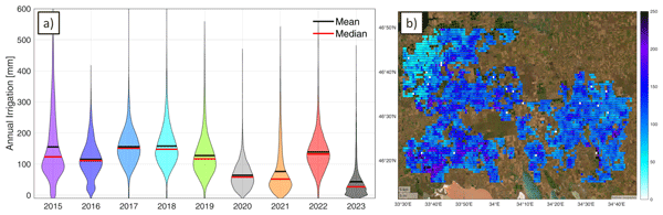
We have developed the first operational system (10 d latency) for estimating irrigation water use from accessible satellite and reanalysis data. As a proof of concept, the method has been implemented over an irrigated area fed by the Kakhovka Reservoir, in Ukraine, which collapsed on June 6, 2023. Estimates for the period 2015–2023 reveal that, as expected, the irrigation season of 2023 was characterized by the lowest amounts of irrigation.
Ashkan Pilbala, Nicoletta Riccardi, Nina Benistati, Vanessa Modesto, Donatella Termini, Dario Manca, Augusto Benigni, Cristiano Corradini, Tommaso Lazzarin, Tommaso Moramarco, Luigi Fraccarollo, and Sebastiano Piccolroaz
Hydrol. Earth Syst. Sci., 28, 2297–2311, https://doi.org/10.5194/hess-28-2297-2024, https://doi.org/10.5194/hess-28-2297-2024, 2024
Short summary
Short summary
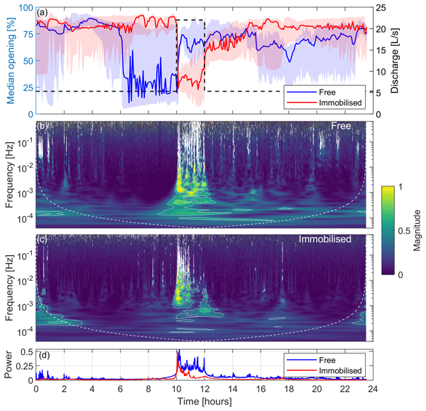
This study investigates the impact of floods on the aquatic ecosystem using freshwater mussels instrumented with sensors to monitor the opening of their valves. Signal analysis techniques were used to gain insight into their responses in terms of changes in the intensity and frequency of valve opening. The approach used in the study enables the development of real-time monitoring systems for ecological purposes and provides a pathway for practical biological early-warning systems.
Søren Julsgaard Kragh, Jacopo Dari, Sara Modanesi, Christian Massari, Luca Brocca, Rasmus Fensholt, Simon Stisen, and Julian Koch
Hydrol. Earth Syst. Sci., 28, 441–457, https://doi.org/10.5194/hess-28-441-2024, https://doi.org/10.5194/hess-28-441-2024, 2024
Short summary
Short summary
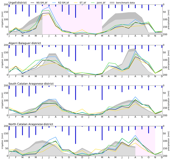
This study provides a comparison of methodologies to quantify irrigation to enhance regional irrigation estimates. To evaluate the methodologies, we compared various approaches to quantify irrigation using soil moisture, evapotranspiration, or both within a novel baseline framework, together with irrigation estimates from other studies. We show that the synergy from using two equally important components in a joint approach within a baseline framework yields better irrigation estimates.
Qianqian Han, Yijian Zeng, Lijie Zhang, Calimanut-Ionut Cira, Egor Prikaziuk, Ting Duan, Chao Wang, Brigitta Szabó, Salvatore Manfreda, Ruodan Zhuang, and Bob Su
Geosci. Model Dev., 16, 5825–5845, https://doi.org/10.5194/gmd-16-5825-2023, https://doi.org/10.5194/gmd-16-5825-2023, 2023
Short summary
Short summary
Using machine learning, we estimated global surface soil moisture (SSM) to aid in understanding water, energy, and carbon exchange. Ensemble models outperformed individual algorithms in predicting SSM under different climates. The best-performing ensemble included K-neighbours Regressor, Random Forest Regressor, and Extreme Gradient Boosting. This is important for hydrological and climatological applications such as water cycle monitoring, irrigation management, and crop yield prediction.
Jacopo Dari, Luca Brocca, Sara Modanesi, Christian Massari, Angelica Tarpanelli, Silvia Barbetta, Raphael Quast, Mariette Vreugdenhil, Vahid Freeman, Anaïs Barella-Ortiz, Pere Quintana-Seguí, David Bretreger, and Espen Volden
Earth Syst. Sci. Data, 15, 1555–1575, https://doi.org/10.5194/essd-15-1555-2023, https://doi.org/10.5194/essd-15-1555-2023, 2023
Short summary
Short summary
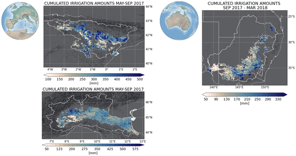
Irrigation is the main source of global freshwater consumption. Despite this, a detailed knowledge of irrigation dynamics (i.e., timing, extent of irrigated areas, and amounts of water used) are generally lacking worldwide. Satellites represent a useful tool to fill this knowledge gap and monitor irrigation water from space. In this study, three regional-scale and high-resolution (1 and 6 km) products of irrigation amounts estimated by inverting the satellite soil moisture signals are presented.
Kunlong He, Wei Zhao, Luca Brocca, and Pere Quintana-Seguí
Hydrol. Earth Syst. Sci., 27, 169–190, https://doi.org/10.5194/hess-27-169-2023, https://doi.org/10.5194/hess-27-169-2023, 2023
Short summary
Short summary
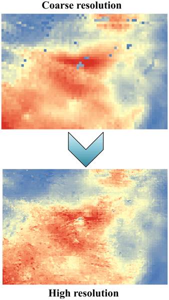
In this study, we developed a soil moisture-based precipitation downscaling (SMPD) method for spatially downscaling the GPM daily precipitation product by exploiting the connection between surface soil moisture and precipitation according to the soil water balance equation. Based on this physical method, the spatial resolution of the daily precipitation product was downscaled to 1 km and the SMPD method shows good potential for the development of the high-resolution precipitation product.
Sara Modanesi, Christian Massari, Michel Bechtold, Hans Lievens, Angelica Tarpanelli, Luca Brocca, Luca Zappa, and Gabriëlle J. M. De Lannoy
Hydrol. Earth Syst. Sci., 26, 4685–4706, https://doi.org/10.5194/hess-26-4685-2022, https://doi.org/10.5194/hess-26-4685-2022, 2022
Short summary
Short summary
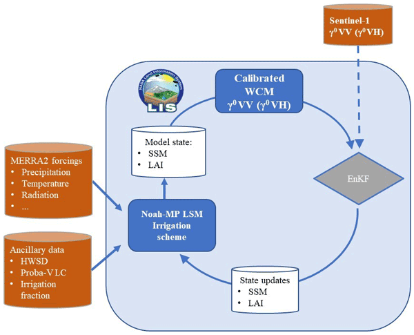
Given the crucial impact of irrigation practices on the water cycle, this study aims at estimating irrigation through the development of an innovative data assimilation system able to ingest high-resolution Sentinel-1 radar observations into the Noah-MP land surface model. The developed methodology has important implications for global water resource management and the comprehension of human impacts on the water cycle and identifies main challenges and outlooks for future research.

Stefania Camici, Gabriele Giuliani, Luca Brocca, Christian Massari, Angelica Tarpanelli, Hassan Hashemi Farahani, Nico Sneeuw, Marco Restano, and Jérôme Benveniste
Geosci. Model Dev., 15, 6935–6956, https://doi.org/10.5194/gmd-15-6935-2022, https://doi.org/10.5194/gmd-15-6935-2022, 2022
Short summary
Short summary
This paper presents an innovative approach, STREAM (SaTellite-based Runoff Evaluation And Mapping), to derive daily river discharge and runoff estimates from satellite observations of soil moisture, precipitation, and terrestrial total water storage anomalies. Potentially useful for multiple operational and scientific applications, the added value of the STREAM approach is the ability to increase knowledge on the natural processes, human activities, and their interactions on the land.
Lorenzo Alfieri, Francesco Avanzi, Fabio Delogu, Simone Gabellani, Giulia Bruno, Lorenzo Campo, Andrea Libertino, Christian Massari, Angelica Tarpanelli, Dominik Rains, Diego G. Miralles, Raphael Quast, Mariette Vreugdenhil, Huan Wu, and Luca Brocca
Hydrol. Earth Syst. Sci., 26, 3921–3939, https://doi.org/10.5194/hess-26-3921-2022, https://doi.org/10.5194/hess-26-3921-2022, 2022
Short summary
Short summary
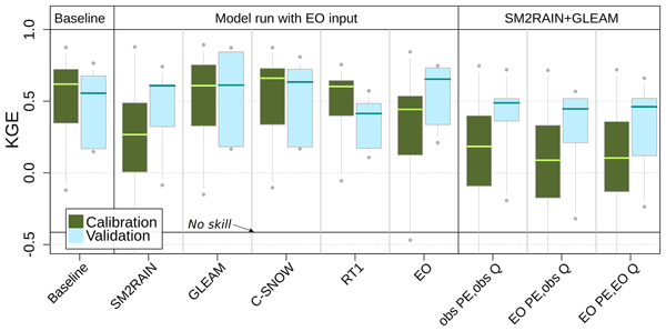
This work shows advances in high-resolution satellite data for hydrology. We performed hydrological simulations for the Po River basin using various satellite products, including precipitation, evaporation, soil moisture, and snow depth. Evaporation and snow depth improved a simulation based on high-quality ground observations. Interestingly, a model calibration relying on satellite data skillfully reproduces observed discharges, paving the way to satellite-driven hydrological applications.
M. G. Ziliani, M. U. Altaf, B. Aragon, R. Houborg, T. E. Franz, Y. Lu, J. Sheffield, I. Hoteit, and M. F. McCabe
Int. Arch. Photogramm. Remote Sens. Spatial Inf. Sci., XLIII-B3-2022, 1045–1052, https://doi.org/10.5194/isprs-archives-XLIII-B3-2022-1045-2022, https://doi.org/10.5194/isprs-archives-XLIII-B3-2022-1045-2022, 2022
Paolo Filippucci, Luca Brocca, Raphael Quast, Luca Ciabatta, Carla Saltalippi, Wolfgang Wagner, and Angelica Tarpanelli
Hydrol. Earth Syst. Sci., 26, 2481–2497, https://doi.org/10.5194/hess-26-2481-2022, https://doi.org/10.5194/hess-26-2481-2022, 2022
Short summary
Short summary
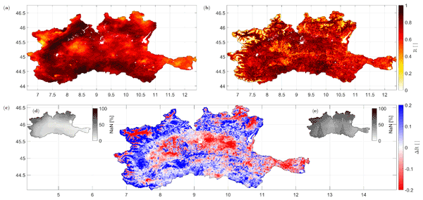
A high-resolution (1 km) rainfall product with 10–30 d temporal resolution was obtained starting from SM data from Sentinel-1. Good performances are achieved using observed data (gauge and radar) over the Po River Valley, Italy, as a benchmark. The comparison with a product characterized by lower spatial resolution (25 km) highlights areas where the high spatial resolution of Sentinel-1 has great benefits. Possible applications include water management, agriculture and index-based insurances.
Wouter Dorigo, Irene Himmelbauer, Daniel Aberer, Lukas Schremmer, Ivana Petrakovic, Luca Zappa, Wolfgang Preimesberger, Angelika Xaver, Frank Annor, Jonas Ardö, Dennis Baldocchi, Marco Bitelli, Günter Blöschl, Heye Bogena, Luca Brocca, Jean-Christophe Calvet, J. Julio Camarero, Giorgio Capello, Minha Choi, Michael C. Cosh, Nick van de Giesen, Istvan Hajdu, Jaakko Ikonen, Karsten H. Jensen, Kasturi Devi Kanniah, Ileen de Kat, Gottfried Kirchengast, Pankaj Kumar Rai, Jenni Kyrouac, Kristine Larson, Suxia Liu, Alexander Loew, Mahta Moghaddam, José Martínez Fernández, Cristian Mattar Bader, Renato Morbidelli, Jan P. Musial, Elise Osenga, Michael A. Palecki, Thierry Pellarin, George P. Petropoulos, Isabella Pfeil, Jarrett Powers, Alan Robock, Christoph Rüdiger, Udo Rummel, Michael Strobel, Zhongbo Su, Ryan Sullivan, Torbern Tagesson, Andrej Varlagin, Mariette Vreugdenhil, Jeffrey Walker, Jun Wen, Fred Wenger, Jean Pierre Wigneron, Mel Woods, Kun Yang, Yijian Zeng, Xiang Zhang, Marek Zreda, Stephan Dietrich, Alexander Gruber, Peter van Oevelen, Wolfgang Wagner, Klaus Scipal, Matthias Drusch, and Roberto Sabia
Hydrol. Earth Syst. Sci., 25, 5749–5804, https://doi.org/10.5194/hess-25-5749-2021, https://doi.org/10.5194/hess-25-5749-2021, 2021
Short summary
Short summary
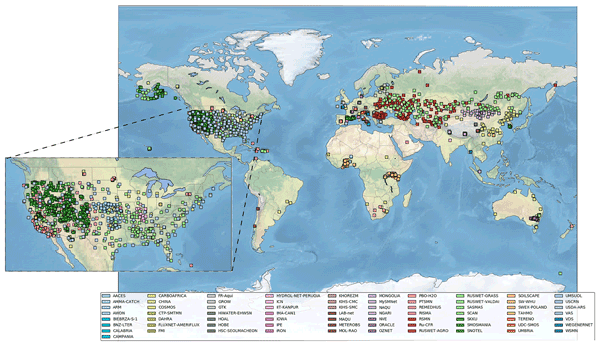
The International Soil Moisture Network (ISMN) is a community-based open-access data portal for soil water measurements taken at the ground and is accessible at https://ismn.earth. Over 1000 scientific publications and thousands of users have made use of the ISMN. The scope of this paper is to inform readers about the data and functionality of the ISMN and to provide a review of the scientific progress facilitated through the ISMN with the scope to shape future research and operations.
Daniele Masseroni, Stefania Camici, Alessio Cislaghi, Giorgio Vacchiano, Christian Massari, and Luca Brocca
Hydrol. Earth Syst. Sci., 25, 5589–5601, https://doi.org/10.5194/hess-25-5589-2021, https://doi.org/10.5194/hess-25-5589-2021, 2021
Short summary
Short summary
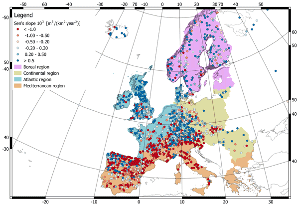
We evaluate 63 years of changes in annual streamflow volume across Europe, using a data set of more than 3000 stations, with a special focus on the Mediterranean basin. The results show decreasing (increasing) volumes in the southern (northern) regions. These trends are strongly consistent with the changes in temperature and precipitation.
Robert Ljubičić, Dariia Strelnikova, Matthew T. Perks, Anette Eltner, Salvador Peña-Haro, Alonso Pizarro, Silvano Fortunato Dal Sasso, Ulf Scherling, Pietro Vuono, and Salvatore Manfreda
Hydrol. Earth Syst. Sci., 25, 5105–5132, https://doi.org/10.5194/hess-25-5105-2021, https://doi.org/10.5194/hess-25-5105-2021, 2021
Short summary
Short summary
The rise of new technologies such as drones (unmanned aerial systems – UASs) has allowed widespread use of image velocimetry techniques in place of more traditional, usually slower, methods during hydrometric campaigns. In order to minimize the velocity estimation errors, one must stabilise the acquired videos. In this research, we compare the performance of different UAS video stabilisation tools and provide guidelines for their use in videos with different flight and ground conditions.
Cited articles
Albergel, C., Rüdiger, C., Pellarin, T., Calvet, J.-C., Fritz, N., Froissard, F., Suquia, D., Petitpa, A., Piguet, B., and Martin, E.: From near-surface to root-zone soil moisture using an exponential filter: an assessment of the method based on in-situ observations and model simulations, Hydrol. Earth Syst. Sci., 12, 1323–1337, https://doi.org/10.5194/hess-12-1323-2008, 2008.
Albergel, C., Dorigo, W., Balsamo, G., Muñoz-Sabater, J., de Rosnay, P., Isaksen, L., Brocca, L., de Jeu, R., and Wagner, W.: Monitoring multi-decadal satellite earth observation of soil moisture products through land surface reanalyses, Remote Sens. Environ., 138, 77–89, https://doi.org/10.1016/j.rse.2013.07.009, 2013.
AMMA: AMMA-CATCH, 2014: Hydrological and meteorological observatory on West Africa, available at: http://www.amma-catch.org, last access: December 2013, 2014.
AMMA Database: AMMA Data User Interface, available at: http://database.amma-international.org/, last access: December 2013, 2014.
Brocca, L., Melone, F., Moramarco, T., Wagner, W., Naeimi, V., Bartalis, Z., and Hasenauer, S.: Improving runoff prediction through the assimilation of the ASCAT soil moisture product, Hydrol. Earth Syst. Sci., 14, 1881–1893, https://doi.org/10.5194/hess-14-1881-2010, 2010.
Brocca, L., Moramarco, T., Melone, F., Wagner, W., Hasenauer, S., and Hahn, S.: Assimilation of surface and root-zone ASCAT soil moisture products into rainfall-runoff modelling, IEEE T. Geosci. Remote, 50, 2542–2555, 2012.
Brooks, R. H. and Corey A. T.: Hydraulic properties of porous media, Hydrol. Pap. 3, Colorado State Univ., Fort Collins, USA, 1964.
Ceballos, A., Scipal, K., Wagner, W., and Mart?nez-Fernandez, J.: Validation of ERS Scatterometer-Derived Soil Moisture Data in the Central Part of the Duero Basin, Spain, Hydrol. Process., 19, 1549–1566, 2005.
Crow, W. T., Kustas, W. P., and Prueger, J. H.: Monitoring root-zone soil moisture through the assimilation of a thermal remote sensing-based soil moisture proxy into a water balance model, Remote Sens. Environ., 112, 1268–1281, 2008.
De Lange, R., Beck, R., Van De Giesen, N., Friesen, J., De Wit, A., and Wagner, W.: Scatterometer-derived soil moisture calibrated for soil texture with a onedimensional water-flow model, IEEE Trans. Geosci. Remote Sens., 46, 4041–4049, https://doi.org/10.1109/TGRS.2008.2000796, 2008.
de Rosnay, P., Gruhier, C., Timouk, F., Baup, F., Mougin, E., Hiernaux, P., Kergoat, L., and LeDantec, V.: Multi-scale soil moisture measurements at the Gourma meso-scale site in Mali, J. Hydrol., 375, 241–252, 2009.
Dorigo, W. A., Wagner, W., Hohensinn, R., Hahn, S., Paulik, C., Xaver, A., Gruber, A., Drusch, M., Mecklenburg, S., van Oevelen, P., Robock, A., and Jackson, T.: The International Soil Moisture Network: a data hosting facility for global in situ soil moisture measurements, Hydrol. Earth Syst. Sci., 15, 1675–1698, https://doi.org/10.5194/hess-15-1675-2011, 2011.
Escorihuela, M., Chanzy, A., Wigneron, J., and Kerr, Y.: Effective soil moisture sampling depth of L-band radiometry: a case study, Remote Sens. Environ., 114, 995–1001, 2010.
Gao, H., Wood, E. F., Jackson, T. J., Drusch, M., and Bindlish, R.: Using TRMM/TMI to Retrieve Surface Soil Moisture over the Southern United States from 1998 to 2002, J. Hydrometeorol., 7, 23–38, 2006.
Green, W. H. and Ampt, G.: Studies of soil physics, part I – the flow of air and water through soils, J. Agr. Sci., 4, 1–24, 1911.
ISMN (International Soil Moisture Network): The ISMN Data Portal, available at: http://ismn.geo.tuwien.ac.at, last access: December 2013, 2014.
Laio, F.: A vertically extended stochastic model of soil moisture in the root zone, Water Resour. Res., 42, W02406, https://doi.org/10.1029/2005WR004502, 2006.
Li, F., Crow, W. T., and Kustas, W. P.: Towards the estimation of root-zone soil moisture via the simultaneous assimilation of thermal and microwave soil moisture retrievals, Adv. Water Resour., 33, 201–214, 2010.
Liang, X., Lettenmaier, D. P., Wood, E. F., and Burges, S. J.: A simple hydrologically based model of land surface water and energy fluxes for GCMs, J. Geophys. Res., 99, 14415–14428, 1994.
Liang, X., Lettenmaier, D. P., and Wood, E. F.: One-dimensional statistical dynamic representation of subgrid spatial variability of precipitation in the two-layer variable infiltration capacity model, J. Geophys. Res., 101, 21403–21422, 1996.
Manfreda, S. and Fiorentino, M.: A stochastic approach for the description of the water balance dynamics in a river basin, Hydrol. Earth Syst. Sci., 12, 1189–1200, https://doi.org/10.5194/hess-12-1189-2008, 2008.
Manfreda, S., McCabe, M., Wood, E. F., Fiorentino, M., and Rodriguez-Iturbe, I.: Spatial Patterns of Soil Moisture from Distributed Modeling, Adv. Water Resour., 30, 2145–2150, 2007.
Manfreda, S., Lacava, T., Onorati, B., Pergola, N., Di Leo, M., Margiotta, M. R., and Tramutoli, V.: On the use of AMSU-based products for the description of soil water content at basin scale, Hydrol. Earth Syst. Sci., 15, 2839–2852, https://doi.org/10.5194/hess-15-2839-2011, 2011.
Matgen, P., Heitz, S., Hasenauer, S., Hissler, C., Brocca, L., Hoffmann, L., Wagner, W., and Savenije, H. H. G.: On the potential of METOP ASCAT-derived soil wetness indices as a new aperture for hydrological monitoring and prediction: a field evaluation over Luxembourg, Hydrol. Process., 26, 2346–2359, 2012a.
Matgen, P., Fenicia, F., Heitz, S., Plaza, D., de Keyser, R., Pauwels, V. R. N., Wagner, W., and Savenije, H.: Can ASCAT-derived soil wetness indices reduce predictive uncertainty in well-gauged areas? A comparison with in situ observed soil moisture in an assimilation application, Advances in Water Resources, 44, 49–65, https://doi.org/10.1016/j.advwatres.2012.03.022, 2012b.
Moran, M. S., Peters-Lidard, C. D., Watts, J. M., and McElroy, S.: Estimating soil moisture at the watershed scale with satellite-based radar and land surface models, Can. J. Remote Sens., 30, 805–826, 2004.
Nied, M., Hundecha, Y., and Merz, B.: Flood-initiating catchment conditions: a spatio-temporal analysis of large-scale soil moisture patterns in the Elbe River basin, Hydrol. Earth Syst. Sci., 17, 1401–1414, https://doi.org/10.5194/hess-17-1401-2013, 2013.
Ochsner, T., Cosh, M., Cuenca, R., Dorigo, W., Draper, C., Hagimoto, Y., Kerr, Y., Larson, K. M., Njoku, E. G., Small, E. E., and Zreda, M.: The state of the art in large-scale soil moisture monitoring, Soil Sci. Soc. Am. J., 77, 1888–1919,https://doi.org/10.2136/sssaj2013.03.0093, 2013.
Pan, F., Peters-Lidard, C. D., and Sale, M. J.: An analytical method for predicting surface soil moisture from rainfall observations, Water Resour. Res., 39, 1314, https://doi.org/10.1029/2003WR002142, 2003.
Pellarin, T., Laurent, J. P., Cappelaere, B., Decharme B., Descroix, L., and Ramier, D.: Hydrological modelling and associated microwave emission of a semi-arid region in South-western Niger, J. Hydrol., 375, 262–272, 2009a.
Pellarin, T., Tran, T., Cohard, J.-M., Galle, S., Laurent, J.-P., de Rosnay, P., and Vischel, T.: Soil moisture mapping over West Africa with a 30-min temporal resolution using AMSR-E observations and a satellite-based rainfall product, Hydrol. Earth Syst. Sci., 13, 1887–1896, https://doi.org/10.5194/hess-13-1887-2009, 2009b.
Porporato, A., Daly, E., and Rodriguez-Iturbe, I.: Soil water balance and ecosystem response to climate change, Am. Nat., 164, 625–632, 2004.
Puma, M. J., Celia, M. A., Rodriguez-Iturbe, I., and Guswa, A. J.: Functional relationship to describe temporal statistics of soil moisture averaged over different depths, Adv. Water Resour., 28, 553–566, 2005.
Ragab, R.: Towards a continuous operational system to estimate the root zone soil moisture from intermittent remotely sensed surface moisture, J. Hydrol., 173, 1–25, 1995.
Rawls, W. J. and Brakensiek D. L.: Estimation of soil water retention and hydraulic properties, in: Unsaturated Flow in Hydrologic Modeling, Kluwer Acad., Dordrecht, Netherlands, 275–300, 1989.
Rawls, W. J., Ahuja, L. R., Brakensiak, D. L., and Shirmohammadi, A.: Infiltration and soil water movement, in: Handbook of Hydrology, edited by: Maidment, D. R., 5.1–5.51, 1993.
Redelsperger, J.-L., Thorncroft, C. D., Diedhiou, A., Lebel, T., Parker, D., and Polcher, J.: African Monsoon Multidisciplinary Analysis: An International Research Project and Field Campaign, B. Am. Meteorol. Soc., 87, 1739–1746, 2006.
Reichle, R., McLaughlin, D., and Entekhabi, D.: Hydrologic data assimilation with the ensemble kalman filter, Mon. Weather Rev., 130, 103–114, 2002.
Reichle, R., Koster, R., Dong, J., and Berg, A.: Global soil moisture from satellite observations, land surface models, and ground data: implications for data assimilation, J. Hydrometeorol., 5, 430–442, 2004.
Rodriguez-Iturbe, I., Isham, V., Cox, D. R., Manfreda, S., and Porporato, A.: Space-time modeling of soil moisture: stochastic rainfall forcing with heterogeneous vegetation, Water Resour. Res., 42, W06D05, https://doi.org/10.1029/2005WR004497, 2006.
Sabater, J. M., Jarlan, L., Calvet, J. C., Bouyssel, F., and De Rosnay, P.: From Near-Surface to Root-Zone Soil Moisture Using Different Assimilation Techniques, J. Hydrometeorol., 8, 194–206, 2007.
Schaefer, G. L., Cosh, M. H., and Jackson, T. J.: The USDA Natural Resources Conservation Service Soil Climate Analysis Network (SCAN), J. Atmos. Ocean. Tech., 24, 2073–2077, 2007.
Scipal, K., Drusch, M., and Wagner, W.: Assimilation of a ERS scatterometer derived soil moisture index in the ECMWF numerical weather prediction system, Adv. Water Resour., 31, 1101–1112, 2008.
Seneviratne, S. I., Corti, T., Davin, E. L., Hirschi, M., Jaeger, E. B., Lehner, I., Orlowsky, B., and Teuling, A. J.: Investigating soil moisture-climate interactions in a changing climate: A review, Earth-Sci. Rev., 99, 125–161, 2010.
Wagner, W., Lemoine, G., and Rott, H.: A method for estimating soil moisture from ERS scatterometer and soil data, Remote Sens. Environ., 70, 191–207, 1999.
Walker, J. P. and Houser, P. R.: Requirements of a global near-surface soil moisture satellite mission: accuracy, repeat time, and spatial resolution, Adv. Water Resour., 27, 785–801, 2004.
Wood, E. F., Lettenmaier, D. P., Liang, X., Nijssen, B., and Wetzel, S. W.: Hydrological modeling of continental-scale basins, Annu. Rev. Earth Pl. Sc., 25, 279–300, 1997.
Ye, M., Meyer, P. D., and Neuman S. P.: On model selection criteria in multimodel analysis, Water Resour. Res., 44, W03428, https://doi.org/10.1029/2008WR006803, 2008.


