
Articles | Volume 21, issue 12
https://doi.org/10.5194/hess-21-6201-2017
© Author(s) 2017. This work is distributed under
the Creative Commons Attribution 4.0 License.
the Creative Commons Attribution 4.0 License.
https://doi.org/10.5194/hess-21-6201-2017
© Author(s) 2017. This work is distributed under
the Creative Commons Attribution 4.0 License.
the Creative Commons Attribution 4.0 License.
Research article
| 
08 Dec 2017
Research article |
| 08 Dec 2017
| 08 Dec 2017
Global-scale evaluation of 22 precipitation datasets using gauge observations and hydrological modeling
Department of Civil and Environmental Engineering, Princeton University, Princeton, New Jersey, USA
Noemi Vergopolan
Department of Civil and Environmental Engineering, Princeton University, Princeton, New Jersey, USA
Department of Civil and Environmental Engineering, Princeton University, Princeton, New Jersey, USA
Vincenzo Levizzani
National Research Council of Italy, Institute of Atmospheric Sciences and Climate (CNR-ISAC), Bologna, Italy
Albert I. J. M. van Dijk
Fenner School of Environment & Society, The Australian National University, Canberra, Australia
Graham P. Weedon
Met Office, Joint Centre for Hydro-Meteorological Research, Wallingford, UK
Luca Brocca
Research Institute for Geo-Hydrological Protection, National Research Council, Perugia, Italy
Florian Pappenberger
European Centre for Medium-Range Weather Forecasts, Shinfield Park, Reading, UK
George J. Huffman
Mesoscale Atmospheric Processes Laboratory, NASA Goddard Space Flight Center, Greenbelt, Maryland, USA
Eric F. Wood
Department of Civil and Environmental Engineering, Princeton University, Princeton, New Jersey, USA
Related authors
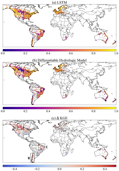
Dapeng Feng, Hylke Beck, Jens de Bruijn, Reetik Kumar Sahu, Yusuke Satoh, Yoshihide Wada, Jiangtao Liu, Ming Pan, Kathryn Lawson, and Chaopeng Shen
Geosci. Model Dev., 17, 7181–7198, https://doi.org/10.5194/gmd-17-7181-2024, https://doi.org/10.5194/gmd-17-7181-2024, 2024
Short summary
Short summary
Accurate hydrologic modeling is vital to characterizing water cycle responses to climate change. For the first time at this scale, we use differentiable physics-informed machine learning hydrologic models to simulate rainfall–runoff processes for 3753 basins around the world and compare them with purely data-driven and traditional modeling approaches. This sets a benchmark for hydrologic estimates around the world and builds foundations for improving global hydrologic simulations.
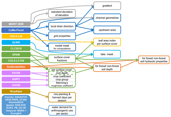
Margarita Choulga, Francesca Moschini, Cinzia Mazzetti, Stefania Grimaldi, Juliana Disperati, Hylke Beck, Peter Salamon, and Christel Prudhomme
Hydrol. Earth Syst. Sci., 28, 2991–3036, https://doi.org/10.5194/hess-28-2991-2024, https://doi.org/10.5194/hess-28-2991-2024, 2024
Short summary
Short summary
CEMS_SurfaceFields_2022 dataset is a new set of high-resolution maps for land type (e.g. lake, forest), soil properties and population water needs at approximately 2 and 6 km at the Equator, covering Europe and the globe (excluding Antarctica). We describe what and how new high-resolution information can be used to create the dataset. The paper suggests that the dataset can be used as input for river, weather or other models, as well as for statistical descriptions of the region of interest.
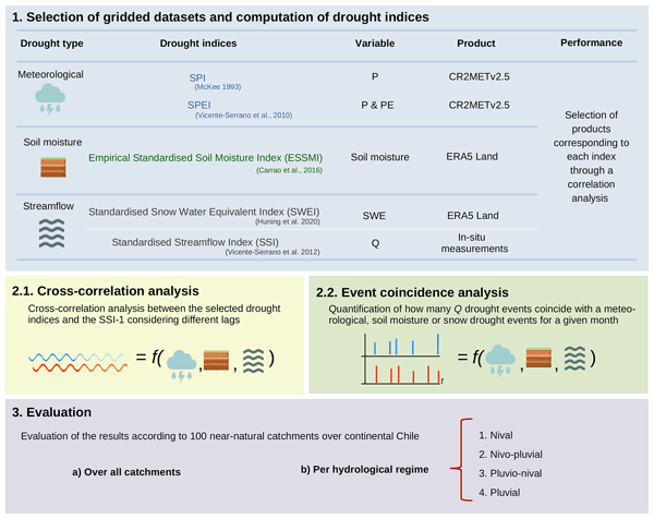
Oscar M. Baez-Villanueva, Mauricio Zambrano-Bigiarini, Diego G. Miralles, Hylke E. Beck, Jonatan F. Siegmund, Camila Alvarez-Garreton, Koen Verbist, René Garreaud, Juan Pablo Boisier, and Mauricio Galleguillos
Hydrol. Earth Syst. Sci., 28, 1415–1439, https://doi.org/10.5194/hess-28-1415-2024, https://doi.org/10.5194/hess-28-1415-2024, 2024
Short summary
Short summary
Various drought indices exist, but there is no consensus on which index to use to assess streamflow droughts. This study addresses meteorological, soil moisture, and snow indices along with their temporal scales to assess streamflow drought across hydrologically diverse catchments. Using data from 100 Chilean catchments, findings suggest that there is not a single drought index that can be used for all catchments and that snow-influenced areas require drought indices with larger temporal scales.
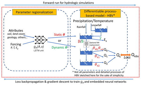
Dapeng Feng, Hylke Beck, Kathryn Lawson, and Chaopeng Shen
Hydrol. Earth Syst. Sci., 27, 2357–2373, https://doi.org/10.5194/hess-27-2357-2023, https://doi.org/10.5194/hess-27-2357-2023, 2023
Short summary
Short summary
Powerful hybrid models (called δ or delta models) embrace the fundamental learning capability of AI and can also explain the physical processes. Here we test their performance when applied to regions not in the training data. δ models rivaled the accuracy of state-of-the-art AI models under the data-dense scenario and even surpassed them for the data-sparse one. They generalize well due to the physical structure included. δ models could be ideal candidates for global hydrologic assessment.
Sara Sadri, James S. Famiglietti, Ming Pan, Hylke E. Beck, Aaron Berg, and Eric F. Wood
Hydrol. Earth Syst. Sci., 26, 5373–5390, https://doi.org/10.5194/hess-26-5373-2022, https://doi.org/10.5194/hess-26-5373-2022, 2022
Short summary
Short summary
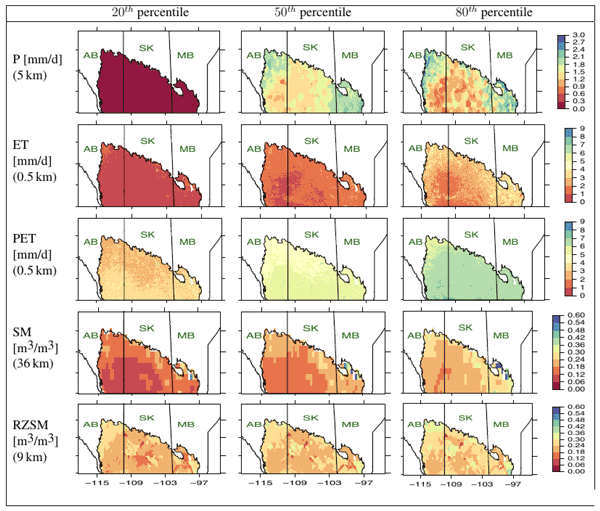
A farm-scale hydroclimatic machine learning framework to advise farmers was developed. FarmCan uses remote sensing data and farmers' input to forecast crop water deficits. The 8 d composite variables are better than daily ones for forecasting water deficit. Evapotranspiration (ET) and potential ET are more effective than soil moisture at predicting crop water deficit. FarmCan uses a crop-specific schedule to use surface or root zone soil moisture.

Jiawei Hou, Albert I. J. M. van Dijk, Hylke E. Beck, Luigi J. Renzullo, and Yoshihide Wada
Hydrol. Earth Syst. Sci., 26, 3785–3803, https://doi.org/10.5194/hess-26-3785-2022, https://doi.org/10.5194/hess-26-3785-2022, 2022
Short summary
Short summary
We used satellite imagery to measure monthly reservoir water volumes for 6695 reservoirs worldwide for 1984–2015. We investigated how changing precipitation, streamflow, evaporation, and human activity affected reservoir water storage. Almost half of the reservoirs showed significant increasing or decreasing trends over the past three decades. These changes are caused, first and foremost, by changes in precipitation rather than by changes in net evaporation or dam release patterns.
Oscar M. Baez-Villanueva, Mauricio Zambrano-Bigiarini, Pablo A. Mendoza, Ian McNamara, Hylke E. Beck, Joschka Thurner, Alexandra Nauditt, Lars Ribbe, and Nguyen Xuan Thinh
Hydrol. Earth Syst. Sci., 25, 5805–5837, https://doi.org/10.5194/hess-25-5805-2021, https://doi.org/10.5194/hess-25-5805-2021, 2021
Short summary
Short summary
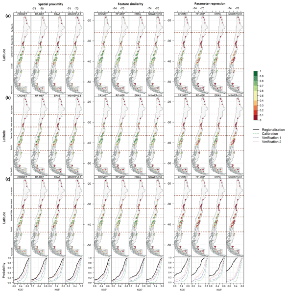
Most rivers worldwide are ungauged, which hinders the sustainable management of water resources. Regionalisation methods use information from gauged rivers to estimate streamflow over ungauged ones. Through hydrological modelling, we assessed how the selection of precipitation products affects the performance of three regionalisation methods. We found that a precipitation product that provides the best results in hydrological modelling does not necessarily perform the best for regionalisation.
Cinzia Mazzetti, Hannah Cloke, Dai Yamazaki, Gianpaolo Balsamo, Souhail Boussetta, Jasper Denissen, Michel Wortmann, Gabriele Arduini, Gurpreet Dass, Joe McNorton, Anna Agusti-Panareda, Maliko Tanguy, Ervin Zsoter, Margarita Choulga, Emanuel Dutra, Florian Pappenberger, Christoph Rüdiger, and Christel Prudhomme
EGUsphere, https://doi.org/10.5194/egusphere-2026-4305, https://doi.org/10.5194/egusphere-2026-4305, 2026
This preprint is open for discussion and under review for Geoscientific Model Development (GMD).
Short summary
Short summary
Rivers are an essential component of the water cycle, yet many Earth system and weather prediction models do not explicitly represent river flow. We integrated a global river model into ECMWF's forecasting system, enabling the simulation of river discharge, water levels, and flooding within a single operational framework. This development lays the foundation for future land–river–atmosphere interactions, paving the way for more complete Earth system models and improved predictions.
Esmaeel Adrah, Luca Brocca, Emine Senkardesler, and He Yin
Earth Syst. Sci. Data Discuss., https://doi.org/10.5194/essd-2026-603, https://doi.org/10.5194/essd-2026-603, 2026
Preprint under review for ESSD
Short summary
Short summary
The eastern Mediterranean is a hotspot for drought, extreme water scarcity, and geopolitical tension, yet long-term data on irrigation is missing. To address this, we used twenty-six years of satellite imagery to track soil moisture and map winter and summer irrigated lands. This freely available data reveals irrigation changes across the region over time, and support managing scarce water resources, understanding climate impacts, and improving regional food security.
Yaji Wang, Bin Peng, Mengqi Jia, Zewei Ma, Qianyu Zhao, Ryan Bailey, Daniel Abrams, Jie Yang, Kaiyu Guan, Ming Pan, and Yuanxin Song
EGUsphere, https://doi.org/10.5194/egusphere-2026-4671, https://doi.org/10.5194/egusphere-2026-4671, 2026
This preprint is open for discussion and under review for Hydrology and Earth System Sciences (HESS).
Short summary
Short summary
Groundwater is critical for supplying rivers and transporting nitrogen, but watershed models describe these processes in different ways. We compared three watershed models with different groundwater detail levels. More detailed simulations better captured underground water movement and nitrogen transport, while simpler approaches provided reliable estimates of groundwater contributions to rivers. The results help researchers and water managers choose models that best fit different applications.
Julia Pfeffer, Benoît Meyssignac, Rory Bingham, Alejandro Blazquez, Marie Bouih, Carla Braitenberg, Luca Brocca, Henryk Dobslaw, Ramiro Ferrari, Ehsan Forootan, Helena Gerdener, Muhammad Tahir Javed, Laura Jensen, Volker Klemann, Anna Kremer, Jürgen Kusche, Gilles Larnicol, Muhammad Usman Liaqat, Francesco Leopardi, Elisavet-Maria Mamagiannou, Gerardo Maurizio, Roland Pail, Isabelle Panet, Thomas Papanikolaou, Peyman Saemian, Ingo Sasgen, Maike Schumacher, Marius Schlaak, Linus Shihora, Alireza Sobouti, Nico Sneeuw, Mohammad Javad Tourian, Dimitrios Tsoulis, Georgios Vergos, Bert Wouters, Fan Yang, and Ilias Daras
EGUsphere, https://doi.org/10.5194/egusphere-2026-4642, https://doi.org/10.5194/egusphere-2026-4642, 2026
This preprint is open for discussion and under review for Earth Observation (EO).
Short summary
Short summary
The ESA SING project demonstrates how the future satellite gravity missions NGGM and MAGIC will improve observations of continental water storage, oceans, glaciers, sea level, earthquakes, and climate change. Their more accurate, higher-resolution gravity measurements will enhance Earth system monitoring, improve climate and hazard assessments, and strengthen operational services for water management, disaster preparedness, and environmental decision-making.
Muhammad Usman Liaqat, Stefania Camici, Francesco Leopardi, Jaime Gaona, and Luca Brocca
Hydrol. Earth Syst. Sci., 30, 4969–4983, https://doi.org/10.5194/hess-30-4969-2026, https://doi.org/10.5194/hess-30-4969-2026, 2026
Short summary
Short summary
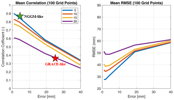
Tracking land water storage helps examine extreme events and manage water resources. GRACE (Gravity Recovery and Climate Experiment) missions observe changes, but coarse resolution in space and time challenges effective management. New gravity mission called MAGIC (Mass Change And Geosciences International Constellation) can offers better accuracy. This study tested MAGIC’s potential to estimate precipitation using the SM2RAIN approach. Results show SM2RAIN works well with frequent, accurate data but deteriorates with noisy/sparse data, emphasizing the need for precise gravity missions.
Prince Xavier, Martin Willett, Tim Graham, Paul Earnshaw, Dan Copsey, Nikesh Narayan, Charline Marzin, Alistair Sellar, Duncan Ackerley, Adam Blaker, Ed Blockley, Alejandro Bodas-Salcedo, Andrew Bushell, Nakbin Choi, Xin Rong Chua, Catherine Guiavarc'h, Muhammad Hassim, Julian Heming, Debra Hudson, Sarah Ineson, Anthony Jones, Colin Jones, Richard Keane, Kiwook Kim, Jiyeong Kim, Till Kuhlbrodt, Myong-In Lee, Richard Levine, Chen Li, Gill Martin, Alex Megann, Anne Mccabe, Aurel Moise, Leighton Regayre, Jeff Ridley, Luke Roberts, Sandeep Sahany, Reinhard K. H. Schiemann, David Storkey, Warren Tennant, Lorenzo Tomassini, Yoko Tsushima, Graham P. Weedon, Alex West, Matthew C. Wheeler, Keith Williams, Xiaobing Zhou, and Hongyan Zhu
EGUsphere, https://doi.org/10.5194/egusphere-2026-4281, https://doi.org/10.5194/egusphere-2026-4281, 2026
This preprint is open for discussion and under review for Geoscientific Model Development (GMD).
Short summary
Short summary
GC5 is the Met Office's newest climate and weather model, combining an updated atmosphere/land component with an improved ocean and sea-ice component. Compared to its predecessor GC4, it better simulates global temperatures, winds, monsoons over India and SE Asia, and African weather, and forecasts tropical cyclones more accurately. Southern Ocean errors shrank too. Some tropical patterns and regional biases worsened slightly. A lower-resolution version will underpin the UK's Earth System Model.
Pierre Laluet, Jacopo Dari, Louise Busschaert, Zdenko Heyvaert, Gabrielle De Lannoy, Pia Langhans, Sara Modanesi, Christian Massari, Luca Brocca, Carla Saltalippi, Renato Morbidelli, Clément Albergel, and Wouter Dorigo
Earth Syst. Sci. Data, 18, 4833–4853, https://doi.org/10.5194/essd-18-4833-2026, https://doi.org/10.5194/essd-18-4833-2026, 2026
Short summary
Short summary
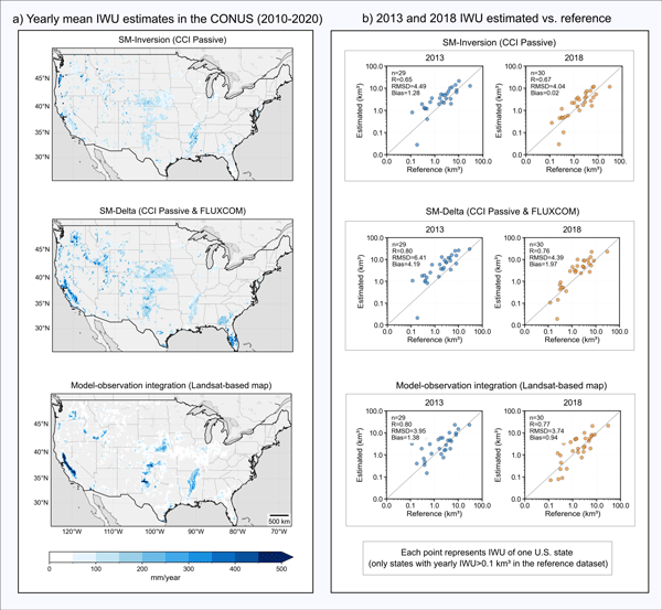
We developed a long-term dataset collection of irrigation water use based on about two decades of satellite observations, three distinct approaches, and many input datasets. The collection provides monthly estimates for major agricultural regions and helps describe how irrigation varies across locations, seasons, and years. It offers a foundation for improving how irrigation is quantified, compared across methods, and integrated into large-scale hydrological and climate studies.
Francesco Avanzi, Hans Lievens, Michael Matiu, Paolo Filippucci, Oscar M. Baez Villanueva, Simone Gabellani, Fabio Delogu, Lorenzo Alfieri, Andrea Libertino, Pere Quintana-Seguì, Diego G. Miralles, Luca Brocca, Christian Massari, and Gabriëlle J. M. De Lannoy
EGUsphere, https://doi.org/10.5194/egusphere-2026-2851, https://doi.org/10.5194/egusphere-2026-2851, 2026
Short summary
Short summary
We developed a new system to map and monitor snow and stored water across large mountain regions using satellite data and computer simulations. Tested in four major European river basins, the system reproduced snow conditions with high accuracy and realistically captured how snow changes with elevation. Because it does not rely on ground measurements, it can help provide consistent information on snow-water resources worldwide, supporting water management and climate adaptation.
Karan Ruparell, Dai Yamazaki, Kieran Hunt, Hannah Cloke, Christel Prudhomme, Florian Pappenberger, and Matthew Chantry
EGUsphere, https://doi.org/10.5194/egusphere-2026-2909, https://doi.org/10.5194/egusphere-2026-2909, 2026
Short summary
Short summary
Reservoirs change how rivers behave, making them harder to predict. We tested whether machine learning models can learn these effects by training on river sites with and without upstream reservoirs across Great Britain. Models without reservoir training overestimated regulated flows, while reservoir-only models performed poorly on natural rivers. Training on both performed well everywhere. All models failed at heavily managed reservoirs where human decisions dominate river flow.
Ather Abbas, Yuan Yang, Ming Pan, Yves Tramblay, Chaopeng Shen, Haoyu Ji, Solomon H. Gebrechorkos, Florian Pappenberger, JongCheol Pyo, Dapeng Feng, George Huffman, Phu Nguyen, Christian Massari, Luca Brocca, Jackson Tan, and Hylke E. Beck
Hydrol. Earth Syst. Sci., 30, 3399–3423, https://doi.org/10.5194/hess-30-3399-2026, https://doi.org/10.5194/hess-30-3399-2026, 2026
Short summary
Short summary
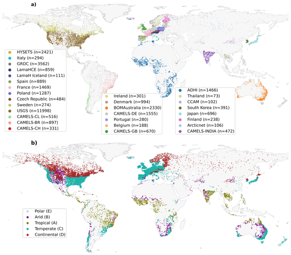
Our study evaluated 24 precipitation datasets using a hydrological model at global scale to assess their suitability and accuracy. We found that MSWEP (Multi-Source Weighted-Ensemble Precipitation) V2.8 excels due to its ability to integrate data from multiple sources, while others, such as IMERG (Integrated Multi-satellitE Retrievals for Global Precipitation Mission) and GDAS (Global Data Assimilation System), demonstrated strong regional performances. This research assists in selecting the appropriate dataset for applications in water resource management, hazard assessment, agriculture, and environmental monitoring.
Peyman Afrasiabikia, Atefeh Parvaresh Rizi, and Luca Brocca
ISPRS Ann. Photogramm. Remote Sens. Spatial Inf. Sci., X-4-W8-2025, 33–38, https://doi.org/10.5194/isprs-annals-X-4-W8-2025-33-2026, https://doi.org/10.5194/isprs-annals-X-4-W8-2025-33-2026, 2026
Haomei Lin, Peirong Lin, Fenghe Zhang, Louise Slater, Yuan Yang, Ming Pan, Qiming Qin, and Aizhong Hou
EGUsphere, https://doi.org/10.5194/egusphere-2026-1834, https://doi.org/10.5194/egusphere-2026-1834, 2026
Preprint archived
Short summary
Short summary
Accurate streamflow reconstruction is crucial for water resources assessment. Traditional models struggle with land-surface changes and human impacts. This study proposes a residual learning framework that leverages Google’s high-resolution satellite embeddings—compact Earth observation data—to improve hydrologic simulations. Our results show that this AI-driven spatial context enhances river modeling accuracy, offering a scalable solution for data-scarce regions.
Hamidreza Mosaffa, Florian Pappenberger, Christel Prudhomme, Matthew Chantry, Christoph Rüdiger, and Hannah Cloke
Hydrol. Earth Syst. Sci., 30, 2079–2092, https://doi.org/10.5194/hess-30-2079-2026, https://doi.org/10.5194/hess-30-2079-2026, 2026
Short summary
Short summary
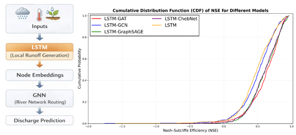
This study improves river flow prediction by combining two types of artificial intelligence models. One model estimates how rainfall becomes runoff in each part of a river basin, while another represents how water moves through the river network. By linking these processes, the approach better captures how water travels across large basins. The results show more accurate streamflow predictions, which can support water management and flood forecasting.
Fatima M. Pillosu, Mariana Claire, Calum Baugh, Florian Pappenberger, Christel Prudhome, and Hannah L. Cloke
EGUsphere, https://doi.org/10.5194/egusphere-2026-1591, https://doi.org/10.5194/egusphere-2026-1591, 2026
Short summary
Short summary
This paper presents the first global, medium-range probabilistic forecasts of flash flood occurrence. A single XGBoost model trained on coarse impact reports achieves skilful predictions, challenging assumptions that complex architectures and high-resolution data are required. At a time of heightened attention to flash flood risk and early warning, this work demonstrates that skilful global forecasting is achievable in data-sparse regions where flash flood risk is highest.
Ehsan Modiri, Oldrich Rakovec, Pallav Kumar Shrestha, Almudena García-García, Leandro Avila, Katie Blackford, Elizabeth Cooper, Bram Droppers, Paolo Filippucci, Milan Fischer, Matěj Orság, Pietro Stradiotti, Luca Brocca, Douglas B. Clark, Wouter Dorigo, Stefan Kollet, Jian Peng, Niko Wanders, and Luis Samaniego
EGUsphere, https://doi.org/10.5194/egusphere-2026-1012, https://doi.org/10.5194/egusphere-2026-1012, 2026
Short summary
Short summary
Drought impacts water supply, agriculture, and ecosystems, yet hydrological models often disagree on when and where drought occurs. This study tested whether satellite observations can improve how models represent soil moisture drought in the Rhine River basin. Using several models and major drought events, we show that satellite data improve spatial realism and reveal important differences among models, helping to better understand uncertainty in drought monitoring and early warning.

Peijun Li, Yalan Song, Ming Pan, Kathryn Lawson, and Chaopeng Shen
Hydrol. Earth Syst. Sci., 29, 6829–6861, https://doi.org/10.5194/hess-29-6829-2025, https://doi.org/10.5194/hess-29-6829-2025, 2025
Short summary
Short summary
This study explores how combining different model types improves streamflow predictions, especially in data-sparse scenarios. By integrating two highly accurate models with distinct mechanisms and leveraging multiple meteorological datasets, we highlight their unique strengths and set new accuracy benchmarks across spatiotemporal conditions. Our findings enhance the understanding of how diverse models and multi-source data can be effectively used to improve hydrological predictions.
Zewei Ma, Kaiyu Guan, Bin Peng, Wang Zhou, Robert Grant, Jinyun Tang, Murugesu Sivapalan, Ming Pan, Li Li, and Zhenong Jin
Hydrol. Earth Syst. Sci., 29, 6393–6417, https://doi.org/10.5194/hess-29-6393-2025, https://doi.org/10.5194/hess-29-6393-2025, 2025
Short summary
Short summary
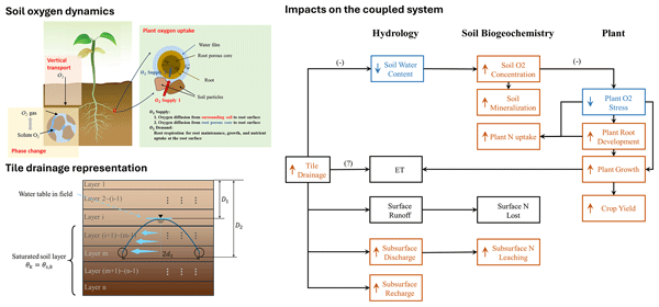
By involving soil oxygen dynamics, we explore tile drainage impacts on the coupled hydrology–biogeochemistry–crop system. We find that soil oxygen dynamics is the key mediator of tile–system dynamics. Tile drainage lowers soil water content and improves soil oxygen levels, helping crops grow during wet springs. The developed roots also help mitigate drought stress in dry summers. Overall, tile drainage increases crop resilience to climate change, making it a valuable future agricultural practice.
Yuan Yang, Ming Pan, Dapeng Feng, Mu Xiao, Taylor Dixon, Robert Hartman, Chaopeng Shen, Yalan Song, Agniv Sengupta, Luca Delle Monache, and F. Martin Ralph
Hydrol. Earth Syst. Sci., 29, 5453–5476, https://doi.org/10.5194/hess-29-5453-2025, https://doi.org/10.5194/hess-29-5453-2025, 2025
Short summary
Short summary
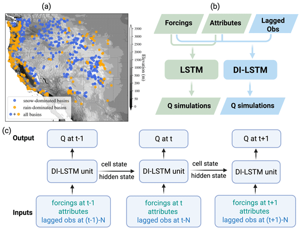
We explore a machine learning-based data integration method that integrates streamflow (Q) and snow water equivalent (SWE) to improve streamflow estimates at various lag times (1–10 d, 1–6 months) and timescales (daily and monthly) over Western US basins. Benefits rank as: integrating Q at the daily scale > Q at the monthly scale > SWE at the monthly scale > SWE at the daily scale. Results highlight the method’s potential for short- and long-term streamflow forecasting in the Western US.
Paolo Filippucci, Luca Brocca, Luca Ciabatta, Hamidreza Mosaffa, Francesco Avanzi, and Christian Massari
Earth Syst. Sci. Data, 17, 5221–5258, https://doi.org/10.5194/essd-17-5221-2025, https://doi.org/10.5194/essd-17-5221-2025, 2025
Short summary
Short summary
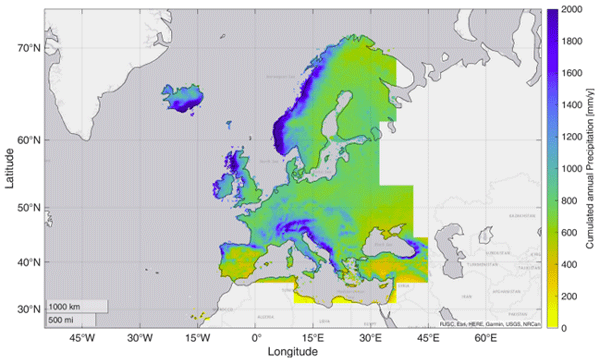
Accurate rainfall data is essential, yet measuring daily precipitation worldwide is challenging. This research presents HYdroclimatic PERformance-enhanced Precipitation (HYPER-P), a dataset combining satellite, ground, and reanalysis data to estimate precipitation at a 1 km scale from 2000 to 2022. HYPER-P improves accuracy, especially in areas with few rain gauges. This dataset supports scientists and decision-makers in understanding and managing water resources more effectively.
Jaime Gaona, Davide Bavera, Guido Fioravanti, Sebastian Hahn, Pietro Stradiotti, Paolo Filippucci, Stefania Camici, Luca Ciabatta, Hamidreza Mosaffa, Silvia Puca, Nicoletta Roberto, and Luca Brocca
Hydrol. Earth Syst. Sci., 29, 3865–3888, https://doi.org/10.5194/hess-29-3865-2025, https://doi.org/10.5194/hess-29-3865-2025, 2025
Short summary
Short summary
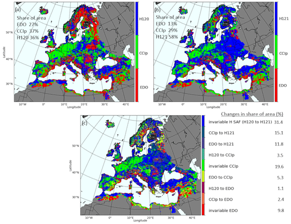
Soil moisture is crucial for the water cycle since it is at the front line of drought. Satellite, model and in situ data help identify soil moisture stress but are challenged by data uncertainties. This study evaluates trends and data coherence of common active/passive microwave sensors and model-based soil moisture data against in situ stations across Europe from 2007 to 2022. Data reliability is increasing, but combining data types improves soil moisture monitoring capabilities.
Nicolas Pucino, Tim McVicar, Shaun Levick, and Albert van Dijk
Int. Arch. Photogramm. Remote Sens. Spatial Inf. Sci., XLVIII-G-2025, 1223–1227, https://doi.org/10.5194/isprs-archives-XLVIII-G-2025-1223-2025, https://doi.org/10.5194/isprs-archives-XLVIII-G-2025-1223-2025, 2025
Marieke Wesselkamp, Matthew Chantry, Ewan Pinnington, Margarita Choulga, Souhail Boussetta, Maria Kalweit, Joschka Bödecker, Carsten F. Dormann, Florian Pappenberger, and Gianpaolo Balsamo
Geosci. Model Dev., 18, 921–937, https://doi.org/10.5194/gmd-18-921-2025, https://doi.org/10.5194/gmd-18-921-2025, 2025
Short summary
Short summary
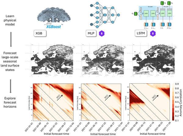
We compared spatiotemporal forecasts of three machine learning models that learned water and energy
states on the land surface from a physical model scheme. The forecasting models were developed with reanalysis data and simulations on a European scale and transferred to the globe. We found that all approaches deliver highly accurate approximations of the physical dynamic at long time horizons, implying their usefulness to advance land surface forecasting with synthetic data.
states on the land surface from a physical model scheme. The forecasting models were developed with reanalysis data and simulations on a European scale and transferred to the globe. We found that all approaches deliver highly accurate approximations of the physical dynamic at long time horizons, implying their usefulness to advance land surface forecasting with synthetic data.
Vishnu U. Krishnan, Noemi Vergopolan, Bhupendra Bahadur Singh, Jayaluxmi Indu, and Lanka Karthikeyan
Hydrol. Earth Syst. Sci. Discuss., https://doi.org/10.5194/hess-2024-339, https://doi.org/10.5194/hess-2024-339, 2024
Revised manuscript not accepted
Short summary
Short summary
Soil moisture has high heterogeneity in areas with marginal agricultural farms. Traditional models do not account for these changes. This study implements a new land model for farm-scale soil moisture first time in India. We enhanced it with depth-varying soil properties and identified their importance for estimating soil moisture across depths and seasons. The modified model improves deep-layer soil moisture at 30 m resolution, with temporal changes consistent with coarse-resolution products.
Ling Zhang, Yanhua Xie, Xiufang Zhu, Qimin Ma, and Luca Brocca
Earth Syst. Sci. Data, 16, 5207–5226, https://doi.org/10.5194/essd-16-5207-2024, https://doi.org/10.5194/essd-16-5207-2024, 2024
Short summary
Short summary
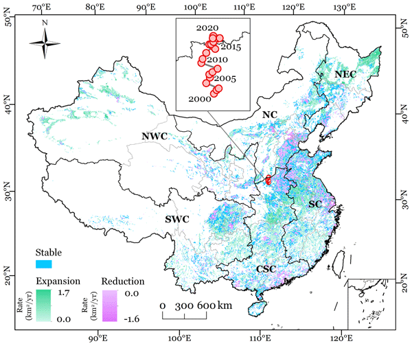
This study presented new annual maps of irrigated cropland in China from 2000 to 2020 (CIrrMap250). These maps were developed by integrating remote sensing data, irrigation statistics and surveys, and an irrigation suitability map. CIrrMap250 achieved high accuracy and outperformed currently available products. The new irrigation maps revealed a clear expansion of China’s irrigation area, with the majority (61%) occurring in the water-unsustainable regions facing severe to extreme water stress.
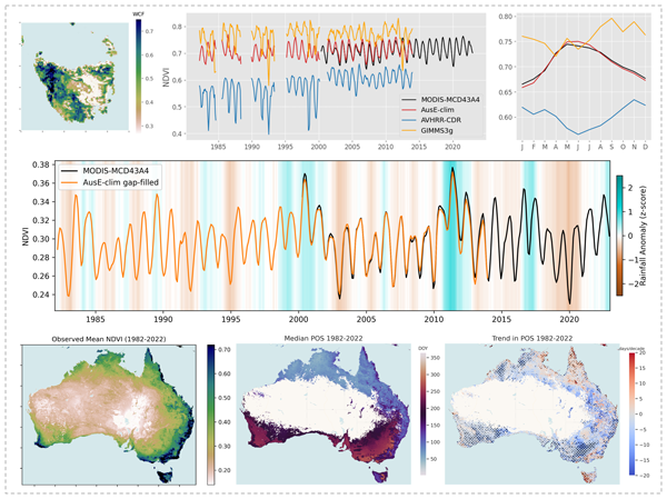
Chad A. Burton, Sami W. Rifai, Luigi J. Renzullo, and Albert I. J. M. Van Dijk
Earth Syst. Sci. Data, 16, 4389–4416, https://doi.org/10.5194/essd-16-4389-2024, https://doi.org/10.5194/essd-16-4389-2024, 2024
Short summary
Short summary
Understanding vegetation response to environmental change requires accurate, long-term data on vegetation condition (VC). We evaluated existing satellite VC datasets over Australia and found them lacking, so we developed a new VC dataset for Australia, AusENDVI. It can be used for studying Australia's changing vegetation dynamics and downstream impacts on the carbon and water cycles, and it provides a reliable foundation for further research into the drivers of vegetation change.
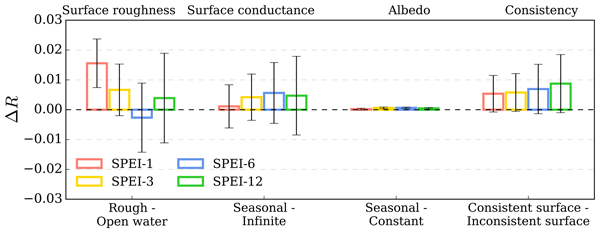
Liqing Peng, Justin Sheffield, Zhongwang Wei, Michael Ek, and Eric F. Wood
Earth Syst. Dynam., 15, 1277–1300, https://doi.org/10.5194/esd-15-1277-2024, https://doi.org/10.5194/esd-15-1277-2024, 2024
Short summary
Short summary
Integrating evaporative demand into drought indicators is effective, but the choice of method and the effectiveness of surface features remain undocumented. We evaluate various methods and surface features for predicting soil moisture dynamics. Using minimal ancillary information alongside meteorological and vegetation data, we develop a simple land-cover-based method that improves soil moisture drought predictions, especially in forests, showing promise for better real-time drought forecasting.
Dapeng Feng, Hylke Beck, Jens de Bruijn, Reetik Kumar Sahu, Yusuke Satoh, Yoshihide Wada, Jiangtao Liu, Ming Pan, Kathryn Lawson, and Chaopeng Shen
Geosci. Model Dev., 17, 7181–7198, https://doi.org/10.5194/gmd-17-7181-2024, https://doi.org/10.5194/gmd-17-7181-2024, 2024
Short summary
Short summary
Accurate hydrologic modeling is vital to characterizing water cycle responses to climate change. For the first time at this scale, we use differentiable physics-informed machine learning hydrologic models to simulate rainfall–runoff processes for 3753 basins around the world and compare them with purely data-driven and traditional modeling approaches. This sets a benchmark for hydrologic estimates around the world and builds foundations for improving global hydrologic simulations.
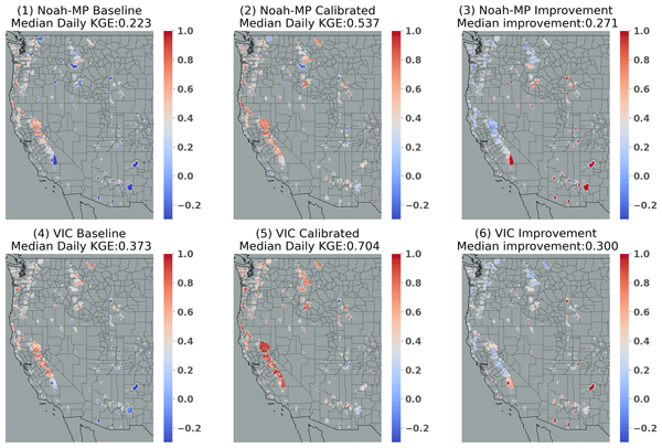
Lu Su, Dennis P. Lettenmaier, Ming Pan, and Benjamin Bass
Hydrol. Earth Syst. Sci., 28, 3079–3097, https://doi.org/10.5194/hess-28-3079-2024, https://doi.org/10.5194/hess-28-3079-2024, 2024
Short summary
Short summary
We fine-tuned the variable infiltration capacity (VIC) and Noah-MP models across 263 river basins in the Western US. We developed transfer relationships to similar basins and extended the fine-tuned parameters to ungauged basins. Both models performed best in humid areas, and the skills improved post-calibration. VIC outperforms Noah-MP in all but interior dry basins following regionalization. VIC simulates annual mean streamflow and high flow well, while Noah-MP performs better for low flows.
Margarita Choulga, Francesca Moschini, Cinzia Mazzetti, Stefania Grimaldi, Juliana Disperati, Hylke Beck, Peter Salamon, and Christel Prudhomme
Hydrol. Earth Syst. Sci., 28, 2991–3036, https://doi.org/10.5194/hess-28-2991-2024, https://doi.org/10.5194/hess-28-2991-2024, 2024
Short summary
Short summary
CEMS_SurfaceFields_2022 dataset is a new set of high-resolution maps for land type (e.g. lake, forest), soil properties and population water needs at approximately 2 and 6 km at the Equator, covering Europe and the globe (excluding Antarctica). We describe what and how new high-resolution information can be used to create the dataset. The paper suggests that the dataset can be used as input for river, weather or other models, as well as for statistical descriptions of the region of interest.
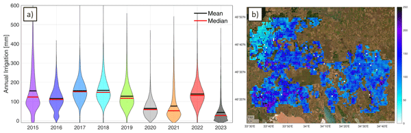
Jacopo Dari, Paolo Filippucci, and Luca Brocca
Hydrol. Earth Syst. Sci., 28, 2651–2659, https://doi.org/10.5194/hess-28-2651-2024, https://doi.org/10.5194/hess-28-2651-2024, 2024
Short summary
Short summary
We have developed the first operational system (10 d latency) for estimating irrigation water use from accessible satellite and reanalysis data. As a proof of concept, the method has been implemented over an irrigated area fed by the Kakhovka Reservoir, in Ukraine, which collapsed on June 6, 2023. Estimates for the period 2015–2023 reveal that, as expected, the irrigation season of 2023 was characterized by the lowest amounts of irrigation.
Yi Y. Liu, Albert I. J. M. van Dijk, Patrick Meir, and Tim R. McVicar
Biogeosciences, 21, 2273–2295, https://doi.org/10.5194/bg-21-2273-2024, https://doi.org/10.5194/bg-21-2273-2024, 2024
Short summary
Short summary
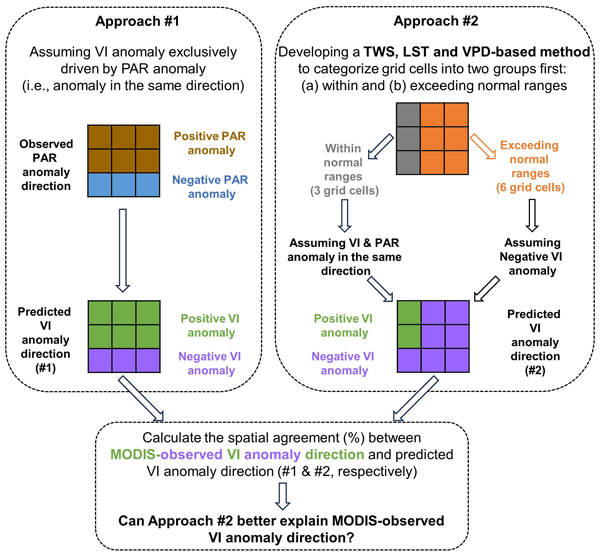
Greenness of the Amazon forest fluctuated during the 2015–2016 drought, but no satisfactory explanation has been found. Based on water storage, temperature, and atmospheric moisture demand, we developed a method to delineate the regions where forests were under stress. These drought-affected regions were mainly identified at the beginning and end of the drought, resulting in below-average greenness. For the months in between, without stress, greenness responded positively to intense sunlight.
Oscar M. Baez-Villanueva, Mauricio Zambrano-Bigiarini, Diego G. Miralles, Hylke E. Beck, Jonatan F. Siegmund, Camila Alvarez-Garreton, Koen Verbist, René Garreaud, Juan Pablo Boisier, and Mauricio Galleguillos
Hydrol. Earth Syst. Sci., 28, 1415–1439, https://doi.org/10.5194/hess-28-1415-2024, https://doi.org/10.5194/hess-28-1415-2024, 2024
Short summary
Short summary
Various drought indices exist, but there is no consensus on which index to use to assess streamflow droughts. This study addresses meteorological, soil moisture, and snow indices along with their temporal scales to assess streamflow drought across hydrologically diverse catchments. Using data from 100 Chilean catchments, findings suggest that there is not a single drought index that can be used for all catchments and that snow-influenced areas require drought indices with larger temporal scales.
Søren Julsgaard Kragh, Jacopo Dari, Sara Modanesi, Christian Massari, Luca Brocca, Rasmus Fensholt, Simon Stisen, and Julian Koch
Hydrol. Earth Syst. Sci., 28, 441–457, https://doi.org/10.5194/hess-28-441-2024, https://doi.org/10.5194/hess-28-441-2024, 2024
Short summary
Short summary
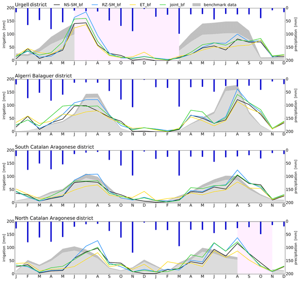
This study provides a comparison of methodologies to quantify irrigation to enhance regional irrigation estimates. To evaluate the methodologies, we compared various approaches to quantify irrigation using soil moisture, evapotranspiration, or both within a novel baseline framework, together with irrigation estimates from other studies. We show that the synergy from using two equally important components in a joint approach within a baseline framework yields better irrigation estimates.
Jiawei Hou, Albert I. J. M. Van Dijk, Luigi J. Renzullo, and Pablo R. Larraondo
Earth Syst. Sci. Data, 16, 201–218, https://doi.org/10.5194/essd-16-201-2024, https://doi.org/10.5194/essd-16-201-2024, 2024
Short summary
Short summary
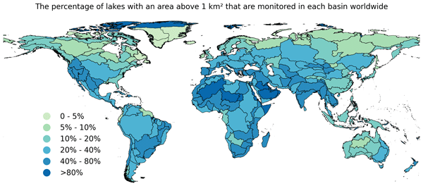
The GloLakes dataset provides historical and near-real-time time series of relative (i.e. storage change) and absolute (i.e. total stored volume) storage for more than 27 000 lakes worldwide using multiple sources of satellite data, including laser and radar altimetry and optical remote sensing. These data can help us understand the influence of climate variability and anthropogenic activities on water availability and system ecology over the last 4 decades.
Chad A. Burton, Luigi J. Renzullo, Sami W. Rifai, and Albert I. J. M. Van Dijk
Biogeosciences, 20, 4109–4134, https://doi.org/10.5194/bg-20-4109-2023, https://doi.org/10.5194/bg-20-4109-2023, 2023
Short summary
Short summary
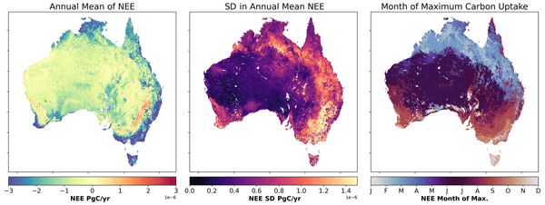
Australia's land-based ecosystems play a critical role in controlling the variability in the global land carbon sink. However, uncertainties in the methods used for quantifying carbon fluxes limit our understanding. We develop high-resolution estimates of Australia's land carbon fluxes using machine learning methods and find that Australia is, on average, a stronger carbon sink than previously thought and that the seasonal dynamics of the fluxes differ from those described by other methods.
Dapeng Feng, Hylke Beck, Kathryn Lawson, and Chaopeng Shen
Hydrol. Earth Syst. Sci., 27, 2357–2373, https://doi.org/10.5194/hess-27-2357-2023, https://doi.org/10.5194/hess-27-2357-2023, 2023
Short summary
Short summary
Powerful hybrid models (called δ or delta models) embrace the fundamental learning capability of AI and can also explain the physical processes. Here we test their performance when applied to regions not in the training data. δ models rivaled the accuracy of state-of-the-art AI models under the data-dense scenario and even surpassed them for the data-sparse one. They generalize well due to the physical structure included. δ models could be ideal candidates for global hydrologic assessment.
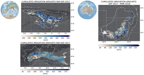
Jacopo Dari, Luca Brocca, Sara Modanesi, Christian Massari, Angelica Tarpanelli, Silvia Barbetta, Raphael Quast, Mariette Vreugdenhil, Vahid Freeman, Anaïs Barella-Ortiz, Pere Quintana-Seguí, David Bretreger, and Espen Volden
Earth Syst. Sci. Data, 15, 1555–1575, https://doi.org/10.5194/essd-15-1555-2023, https://doi.org/10.5194/essd-15-1555-2023, 2023
Short summary
Short summary
Irrigation is the main source of global freshwater consumption. Despite this, a detailed knowledge of irrigation dynamics (i.e., timing, extent of irrigated areas, and amounts of water used) are generally lacking worldwide. Satellites represent a useful tool to fill this knowledge gap and monitor irrigation water from space. In this study, three regional-scale and high-resolution (1 and 6 km) products of irrigation amounts estimated by inverting the satellite soil moisture signals are presented.
Marissa Kivi, Noemi Vergopolan, and Hamze Dokoohaki
Hydrol. Earth Syst. Sci., 27, 1173–1199, https://doi.org/10.5194/hess-27-1173-2023, https://doi.org/10.5194/hess-27-1173-2023, 2023
Short summary
Short summary
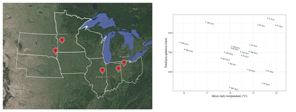
This study attempts to provide a framework for direct integration of soil moisture observations collected from soil sensors and satellite imagery into process-based crop models for improving the representation of agricultural systems. The performance of this framework was evaluated across 19 sites times years for crop yield, normalized difference vegetation index (NDVI), soil moisture, tile flow drainage, and nitrate leaching.
Kunlong He, Wei Zhao, Luca Brocca, and Pere Quintana-Seguí
Hydrol. Earth Syst. Sci., 27, 169–190, https://doi.org/10.5194/hess-27-169-2023, https://doi.org/10.5194/hess-27-169-2023, 2023
Short summary
Short summary
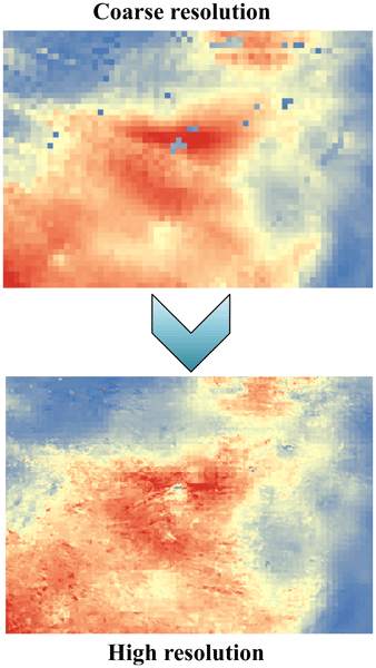
In this study, we developed a soil moisture-based precipitation downscaling (SMPD) method for spatially downscaling the GPM daily precipitation product by exploiting the connection between surface soil moisture and precipitation according to the soil water balance equation. Based on this physical method, the spatial resolution of the daily precipitation product was downscaled to 1 km and the SMPD method shows good potential for the development of the high-resolution precipitation product.
Kieran M. R. Hunt, Gwyneth R. Matthews, Florian Pappenberger, and Christel Prudhomme
Hydrol. Earth Syst. Sci., 26, 5449–5472, https://doi.org/10.5194/hess-26-5449-2022, https://doi.org/10.5194/hess-26-5449-2022, 2022
Short summary
Short summary
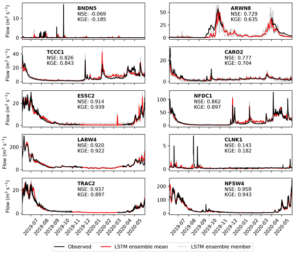
In this study, we use three models to forecast river streamflow operationally for 13 months (September 2020 to October 2021) at 10 gauges in the western US. The first model is a state-of-the-art physics-based streamflow model (GloFAS). The second applies a bias-correction technique to GloFAS. The third is a type of neural network (an LSTM). We find that all three are capable of producing skilful forecasts but that the LSTM performs the best, with skilful 5 d forecasts at nine stations.
Sara Sadri, James S. Famiglietti, Ming Pan, Hylke E. Beck, Aaron Berg, and Eric F. Wood
Hydrol. Earth Syst. Sci., 26, 5373–5390, https://doi.org/10.5194/hess-26-5373-2022, https://doi.org/10.5194/hess-26-5373-2022, 2022
Short summary
Short summary
A farm-scale hydroclimatic machine learning framework to advise farmers was developed. FarmCan uses remote sensing data and farmers' input to forecast crop water deficits. The 8 d composite variables are better than daily ones for forecasting water deficit. Evapotranspiration (ET) and potential ET are more effective than soil moisture at predicting crop water deficit. FarmCan uses a crop-specific schedule to use surface or root zone soil moisture.
Sara Modanesi, Christian Massari, Michel Bechtold, Hans Lievens, Angelica Tarpanelli, Luca Brocca, Luca Zappa, and Gabriëlle J. M. De Lannoy
Hydrol. Earth Syst. Sci., 26, 4685–4706, https://doi.org/10.5194/hess-26-4685-2022, https://doi.org/10.5194/hess-26-4685-2022, 2022
Short summary
Short summary
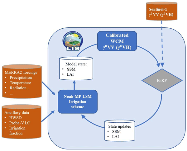
Given the crucial impact of irrigation practices on the water cycle, this study aims at estimating irrigation through the development of an innovative data assimilation system able to ingest high-resolution Sentinel-1 radar observations into the Noah-MP land surface model. The developed methodology has important implications for global water resource management and the comprehension of human impacts on the water cycle and identifies main challenges and outlooks for future research.

Stefania Camici, Gabriele Giuliani, Luca Brocca, Christian Massari, Angelica Tarpanelli, Hassan Hashemi Farahani, Nico Sneeuw, Marco Restano, and Jérôme Benveniste
Geosci. Model Dev., 15, 6935–6956, https://doi.org/10.5194/gmd-15-6935-2022, https://doi.org/10.5194/gmd-15-6935-2022, 2022
Short summary
Short summary
This paper presents an innovative approach, STREAM (SaTellite-based Runoff Evaluation And Mapping), to derive daily river discharge and runoff estimates from satellite observations of soil moisture, precipitation, and terrestrial total water storage anomalies. Potentially useful for multiple operational and scientific applications, the added value of the STREAM approach is the ability to increase knowledge on the natural processes, human activities, and their interactions on the land.
Lorenzo Alfieri, Francesco Avanzi, Fabio Delogu, Simone Gabellani, Giulia Bruno, Lorenzo Campo, Andrea Libertino, Christian Massari, Angelica Tarpanelli, Dominik Rains, Diego G. Miralles, Raphael Quast, Mariette Vreugdenhil, Huan Wu, and Luca Brocca
Hydrol. Earth Syst. Sci., 26, 3921–3939, https://doi.org/10.5194/hess-26-3921-2022, https://doi.org/10.5194/hess-26-3921-2022, 2022
Short summary
Short summary
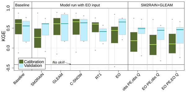
This work shows advances in high-resolution satellite data for hydrology. We performed hydrological simulations for the Po River basin using various satellite products, including precipitation, evaporation, soil moisture, and snow depth. Evaporation and snow depth improved a simulation based on high-quality ground observations. Interestingly, a model calibration relying on satellite data skillfully reproduces observed discharges, paving the way to satellite-driven hydrological applications.
Jiawei Hou, Albert I. J. M. van Dijk, Hylke E. Beck, Luigi J. Renzullo, and Yoshihide Wada
Hydrol. Earth Syst. Sci., 26, 3785–3803, https://doi.org/10.5194/hess-26-3785-2022, https://doi.org/10.5194/hess-26-3785-2022, 2022
Short summary
Short summary
We used satellite imagery to measure monthly reservoir water volumes for 6695 reservoirs worldwide for 1984–2015. We investigated how changing precipitation, streamflow, evaporation, and human activity affected reservoir water storage. Almost half of the reservoirs showed significant increasing or decreasing trends over the past three decades. These changes are caused, first and foremost, by changes in precipitation rather than by changes in net evaporation or dam release patterns.
Paolo Filippucci, Luca Brocca, Raphael Quast, Luca Ciabatta, Carla Saltalippi, Wolfgang Wagner, and Angelica Tarpanelli
Hydrol. Earth Syst. Sci., 26, 2481–2497, https://doi.org/10.5194/hess-26-2481-2022, https://doi.org/10.5194/hess-26-2481-2022, 2022
Short summary
Short summary
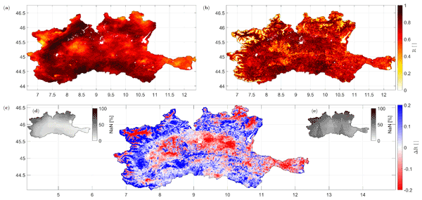
A high-resolution (1 km) rainfall product with 10–30 d temporal resolution was obtained starting from SM data from Sentinel-1. Good performances are achieved using observed data (gauge and radar) over the Po River Valley, Italy, as a benchmark. The comparison with a product characterized by lower spatial resolution (25 km) highlights areas where the high spatial resolution of Sentinel-1 has great benefits. Possible applications include water management, agriculture and index-based insurances.
Oscar M. Baez-Villanueva, Mauricio Zambrano-Bigiarini, Pablo A. Mendoza, Ian McNamara, Hylke E. Beck, Joschka Thurner, Alexandra Nauditt, Lars Ribbe, and Nguyen Xuan Thinh
Hydrol. Earth Syst. Sci., 25, 5805–5837, https://doi.org/10.5194/hess-25-5805-2021, https://doi.org/10.5194/hess-25-5805-2021, 2021
Short summary
Short summary
Most rivers worldwide are ungauged, which hinders the sustainable management of water resources. Regionalisation methods use information from gauged rivers to estimate streamflow over ungauged ones. Through hydrological modelling, we assessed how the selection of precipitation products affects the performance of three regionalisation methods. We found that a precipitation product that provides the best results in hydrological modelling does not necessarily perform the best for regionalisation.
Nathaniel W. Chaney, Laura Torres-Rojas, Noemi Vergopolan, and Colby K. Fisher
Geosci. Model Dev., 14, 6813–6832, https://doi.org/10.5194/gmd-14-6813-2021, https://doi.org/10.5194/gmd-14-6813-2021, 2021
Short summary
Short summary
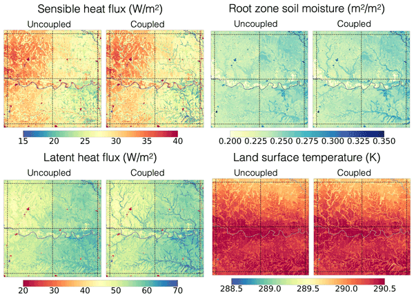
Although there have been significant advances in river routing and sub-grid heterogeneity (i.e., tiling) schemes in Earth system models over the past decades, there has yet to be a concerted effort to couple these two concepts. This paper aims to bridge this gap through the development of a two-way coupling between tiling schemes and river networks in the HydroBlocks land surface model. The scheme is implemented and tested over a 1 arc degree domain in Oklahoma, United States.
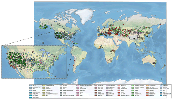
Wouter Dorigo, Irene Himmelbauer, Daniel Aberer, Lukas Schremmer, Ivana Petrakovic, Luca Zappa, Wolfgang Preimesberger, Angelika Xaver, Frank Annor, Jonas Ardö, Dennis Baldocchi, Marco Bitelli, Günter Blöschl, Heye Bogena, Luca Brocca, Jean-Christophe Calvet, J. Julio Camarero, Giorgio Capello, Minha Choi, Michael C. Cosh, Nick van de Giesen, Istvan Hajdu, Jaakko Ikonen, Karsten H. Jensen, Kasturi Devi Kanniah, Ileen de Kat, Gottfried Kirchengast, Pankaj Kumar Rai, Jenni Kyrouac, Kristine Larson, Suxia Liu, Alexander Loew, Mahta Moghaddam, José Martínez Fernández, Cristian Mattar Bader, Renato Morbidelli, Jan P. Musial, Elise Osenga, Michael A. Palecki, Thierry Pellarin, George P. Petropoulos, Isabella Pfeil, Jarrett Powers, Alan Robock, Christoph Rüdiger, Udo Rummel, Michael Strobel, Zhongbo Su, Ryan Sullivan, Torbern Tagesson, Andrej Varlagin, Mariette Vreugdenhil, Jeffrey Walker, Jun Wen, Fred Wenger, Jean Pierre Wigneron, Mel Woods, Kun Yang, Yijian Zeng, Xiang Zhang, Marek Zreda, Stephan Dietrich, Alexander Gruber, Peter van Oevelen, Wolfgang Wagner, Klaus Scipal, Matthias Drusch, and Roberto Sabia
Hydrol. Earth Syst. Sci., 25, 5749–5804, https://doi.org/10.5194/hess-25-5749-2021, https://doi.org/10.5194/hess-25-5749-2021, 2021
Short summary
Short summary
The International Soil Moisture Network (ISMN) is a community-based open-access data portal for soil water measurements taken at the ground and is accessible at https://ismn.earth. Over 1000 scientific publications and thousands of users have made use of the ISMN. The scope of this paper is to inform readers about the data and functionality of the ISMN and to provide a review of the scientific progress facilitated through the ISMN with the scope to shape future research and operations.
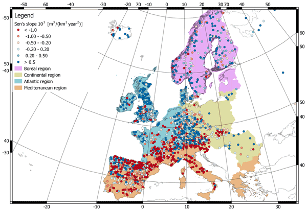
Daniele Masseroni, Stefania Camici, Alessio Cislaghi, Giorgio Vacchiano, Christian Massari, and Luca Brocca
Hydrol. Earth Syst. Sci., 25, 5589–5601, https://doi.org/10.5194/hess-25-5589-2021, https://doi.org/10.5194/hess-25-5589-2021, 2021
Short summary
Short summary
We evaluate 63 years of changes in annual streamflow volume across Europe, using a data set of more than 3000 stations, with a special focus on the Mediterranean basin. The results show decreasing (increasing) volumes in the southern (northern) regions. These trends are strongly consistent with the changes in temperature and precipitation.
Cited articles
Adler, R. F., Kidd, C., Petty, G., Morissey, M., and Goodman, H. M.: Intercomparison of global precipitation products: The third precipitation intercomparison project (PIP-3), B. Am. Meteorol. Soc., 82, 1377–1396, 2001.
AghaKouchak, A., Behrangi, A., Sorooshian, S., Hsu, K., and Amitai, E.: Evaluation of satellite-retrieved extreme precipitation rates across the central United States, J. Geophys. Res., 116, D02115, https://doi.org/10.1029/2010JD014741, 2011.
Akinremi, O. O., McGinn, S. M., and Cutforth, H. W.: Precipitation trends on the Canadian prairies, J. Climate, 12, 2996–3003, 1999.
Albergel, C., Dorigo, W., Reichle, R. H., Balsamo, G., de Rosnay, P., Muñoz Sabater, J. M., Isaksen, L., de Jeu, R., and Wagner, W.: Skill and global trend analysis of soil moisture from reanalyses and microwave remote sensing, J. Hydrometeorol., 14, 1259–1277, 2013.
Alijanian, M., Rakhshandehroo, G. R., Mishra, A. K., and Dehghani, M.: Evaluation of satellite rainfall climatology using CMORPH, PERSIANN-CDR, PERSIANN, TRMM, MSWEP over Iran, Int. J. Climatol., 37, 4896–4914, 2017.
Andréassian, V., Lerat, J., Loumagne, C., Mathevet, T., Michel, C., Oudin, L., and Perrin, C.: What is really undermining hydrologic science today?, Hydrol. Process., 21, 2819–2822, 2007.
Arakawa, A.: The cumulus parameterization problem: past, present, and future, J. Climate, 17, 2493–2525, 2004.
Ashlock, D.: Evolutionary computation for modeling and optimization, Springer Publishing Company, New York, 2010.
Ashouri, H., Hsu, K., Sorooshian, S., Braithwaite, D. K., Knapp, K. R., Cecil, L. D., Nelson, B. R., and Pratt, O. P.: PERSIANN-CDR: daily precipitation climate data record from multisatellite observations for hydrological and climate studies, B. Am. Meteorol. Soc., 96, 69–83, 2015.
Ashouri, H., Nguyen, P., Thorstensen, A., Hsu, K., Sorooshian, S., and Braithwaite, D.: Assessing the efficacy of high-resolution satellite-based PERSIANN-CDR precipitation product in simulating streamflow, J. Hydrometeorol., 17, 2061–2076, 2016.
Barrett, E. C., Adler, R. F., Arpe, K., Bauer, P., Berg, W., Chang, A., Ferraro, R., Ferriday, J., Goodman, S., Hong, Y., Janowiak, J., Kidd, C., Kniveton, D., Morrissey, M., Olson, W., Petty, G., Rudolf, B., Shibata, A., Smith, E., and Spencer, R.: The first WetNet precipitation intercomparison project (PIP-1): Interpretation of results, Remote Sensing Reviews, 11, 303–373, https://doi.org/10.1080/02757259409532268, 1994.
Beck, H. E.: MSWEP Version 2 documentation, Tech. rep., Princeton University, www.gloh2o.org, last access: August 2017.
Beck, H. E., Bruijnzeel, L. A., van Dijk, A. I. J. M., McVicar, T. R., Scatena, F. N., and Schellekens, J.: The impact of forest regeneration on streamflow in 12 mesoscale humid tropical catchments, Hydrol. Earth Syst. Sci., 17, 2613–2635, https://doi.org/10.5194/hess-17-2613-2013, 2013.
Beck, H. E., van Dijk, A. I. J. M., and de Roo, A.: Global maps of streamflow characteristics based on observations from several thousand catchments, J. Hydrometeorol., 16, 1478–1501, 2015.
Beck, H. E., van Dijk, A. I. J. M., de Roo, A., Miralles, D. G., McVicar, T. R., Schellekens, J., and Bruijnzeel, L. A.: Global-scale regionalization of hydrologic model parameters, Water Resour. Res., 52, 3599–3622, https://doi.org/10.1002/2015WR018247, 2016.
Beck, H. E., van Dijk, A. I. J. M., Levizzani, V., Schellekens, J., Miralles, D. G., Martens, B., and de Roo, A.: MSWEP: 3-hourly 0.25° global gridded precipitation (1979–2015) by merging gauge, satellite, and reanalysis data, Hydrol. Earth Syst. Sci., 21, 589–615, https://doi.org/10.5194/hess-21-589-2017, 2017a.
Beck, H. E., van Dijk, A. I. J. M., de Roo, A., Dutra, E., Fink, G., Orth, R., and Schellekens, J.: Global evaluation of runoff from 10 state-of-the-art hydrological models, Hydrol. Earth Syst. Sci., 21, 2881–2903, https://doi.org/10.5194/hess-21-2881-2017, 2017b.
Behrangi, A., Khakbaz, B., Jaw, T. C., AghaKouchak, A., Hsu, K., and Sorooshian, S.: Hydrologic evaluation of satellite precipitation products over a mid-size basin, J. Hydrol., 397, 225–237, 2011.
Bengtsson, L., Hagemann, S., and Hodges, K. I.: Can climate trends be calculated from reanalysis data?, J. Geophys. Res., 109, D11111, https://doi.org/10.1029/2004JD004536, 2004.
Bergström, S.: The HBV model – its structure and applications, SMHI Reports RH 4, Swedish Meteorological and Hydrological Institute (SMHI), Norrköping, Sweden, 1992.
Bitew, M. M., Gebremichael, M., Ghebremichael, L. T., and Bayissa, Y. A.: Evaluation of high-resolution satellite rainfall products through streamflow simulation in a hydrological modeling of a small mountainous watershed in Ethiopia, J. Hydrometeorol., 13, 338–350, 2012.
Bock, A. R., Hay, L. E., McCabe, G. J., Markstrom, S. L., and Atkinson, R. D.: Parameter regionalization of a monthly water balance model for the conterminous United States, Hydrol. Earth Syst. Sci., 20, 2861–2876, https://doi.org/10.5194/hess-20-2861-2016, 2016.
Bosilovich, M. G., Chen, J., Robertson, F. R., and Adler, R. F.: Evaluation of global precipitation in reanalyses, J. Appl. Meteorol. Clim., 47, 2279–2299, 2008.
Brocca, L., Ciabatta, L., Massari, C., Moramarco, T., Hahn, S., Hasenauer, S., Kidd, R., Dorigo, W., Wagner, W., and Levizzani, V.: Soil as a natural rain gauge: estimating global rainfall from satellite soil moisture data, J. Geophys. Res.-Atmos., 119, 5128–5141, 2014.
Buarque, D. C., de Paiva, R. C. D., Clarke, R. T., and Mendes, C. A. B.: A comparison of Amazon rainfall characteristics derived from TRMM, CMORPH and the Brazilian national rain gauge network, J. Geophys. Res., 116, D19105, https://doi.org/10.1029/2011JD016060, 2011.
Bumke, K., König-Langlo, G., Kinzel, J., and Schröder, M.: HOAPS and ERA-Interim precipitation over the sea: validation against shipboard in situ measurements, Atmos. Meas. Tech., 9, 2409–2423, https://doi.org/10.5194/amt-9-2409-2016, 2016.
Cattani, E., Merino, A., and Levizzani, V.: Evaluation of monthly satellite-derived precipitation products over East Africa, J. Hydrometeorol., 17, 2555–2573, 2016.
Cecil, D. J., Buechler, D. E., and Blakeslee, R. J.: Gridded lightning climatology from TRMM-LIS and OTD: Dataset description, Atmos. Res., 135, 404–414, https://doi.org/10.1016/j.atmosres.2012.06.028, 2014.
Chai, T. and Draxler, R. R.: Root mean square error (RMSE) or mean absolute error (MAE)? – Arguments against avoiding RMSE in the literature, Geosci. Model Dev., 7, 1247–1250, https://doi.org/10.5194/gmd-7-1247-2014, 2014.
Chen, M., Shi, W., Xie, P., Silva, V. B. S., Kousky, V. E., Higgins, R. W., and Janowiak, J. E.: Assessing objective techniques for gauge-based analyses of global daily precipitation, J. Geophys. Res., 113, D04110, https://doi.org/10.1029/2007JD009132, 2008.
Chen, S., Hong, Y., Gourley, J. J., Huffman, G. J., Tian, Y., Cao, Q., Yong, B., Kirstetter, P.-E., Hu, J., Hardy, J., Li, Z., Khan, S. I., and Xue, X.: Evaluation of the successive V6 and V7 TRMM multisatellite precipitation analysis over the Continental United States, Water Resources Research, 49, 8174–8186, 2013.
Ciabatta, L., Massari, C., Brocca, L., Gruber, A., Reimer, C., Hahn, S., Paulik, C., Dorigo, W., Kidd, R., and Wagner, W.: SM2RAIN-CCI: A new global long-term rainfall data set derived from ESA CCI soil moisture, Earth Syst. Sci. Data Discuss., https://doi.org/10.5194/essd-2017-86, in review, 2017.
Clark, P., Roberts, N., Lean, H., Ballard, S. P., and Charlton-Perez, C.: Convection-permitting models: a step-change in rainfall forecasting, Meteorol. Appl., 23, 165–181, 2016.
Collischonn, B., Collischonn, W., and Tucci, C. E. M.: Daily hydrological modeling in the Amazon basin using TRMM rainfall estimates, J. Hydrol., 360, 207–216, 2008.
Criss, R. E. and Winston, W. E.: Do Nash values have value? Discussion and alternate proposals, Hydrol. Process., 22, 2723–2725, 2008.
Crow, W. T., van den Berg, M. J., Huffman, G. J., and Pellarin, T.: Correcting rainfall using satellite-based surface soil moisture retrievals: The Soil Moisture Analysis Rainfall Tool (SMART), Water Resour. Res., 47, W08521, https://doi.org/10.1029/2011WR010576, 2011.
Daly, C., Halbleib, M., Smith, J. I., Gibson, W. P., Doggett, M. K., Taylor, G. H., Curtis, J., and Pasteris, P. P.: Physiographically sensitive mapping of climatological temperature and precipitation across the conterminous United States, Int. J. Climatol., 28, 2031–2064, 2008.
Dee, D. P., Uppala, S. M., Simmons, A. J., Berrisford, P., Poli, P., Kobayashi, S., Andrae, U., Balmaseda, M. A., Balsamo, G., Bauer, P., Bechtold, P., Beljaars, A. C. M., van de Berg, L., Bidlot, J., Bormann, N., Delsol, C., Dragani, R., Fuentes, M., Geer, A. J., Haimberger, L., Healy, S. B., Hersbach, H., Hólm, E. V., Isaksen, L., Kallberg, P., Köhler, M., Matricardi, M., McNally, A. P., Monge-Sanz, B. M., Morcrette, J.-J., Park, B.-K., Peubey, C., de Rosnay, P., Tavolato, C., Thépaut, J.-N., and Vitart, F.: The ERA-Interim reanalysis: configuration and performance of the data assimilation system, Q. J. Roy. Meteor. Soc., 137, 553–597, 2011.
Deelstra, J., Farkas, C., Engebretsen, A., Kværnø, S., Beldring, S., Olszewska, A., and Nesheim, L.: Can we simulate runoff from agriculture dominated watersheds? Comparison of the DrainMod, SWAT, HBV, COUP and INCA models applied for the Skuterud catchment, Bioforsk FOKUS, 5, 119–128, 2010.
Di Giuseppe, F., Molteni, F., and Dutra, E.: Real-time correction of ERA-Interim monthly rainfall, Geophys. Res. Lett., 40, 3750–3755, 2013.
Dinku, T., Ceccato, P., and Connor, S. J.: Challenges of satellite rainfall estimation over mountainous and arid parts of east Africa, Int. J. Remote Sens., 32, 5965–5979, 2016.
Driouech, F., Déqué, M., and Mokssit, A.: Numerical simulation of the probability distribution function of precipitation over Morocco, Clim. Dynam., 32, 1055–1063, 2009.
Ebert, E. E.: Methods for Verifying Satellite Precipitation Estimates, in: Measuring Precipitation From Space, edited by: Levizzani, V., Bauer, P., and Turk, F. J., Advances In Global Change Research, Springer, Dordrecht, 28, 345–356, 2007.
Ebert, E. E., Janowiak, J. E., and Kidd, C.: Comparison of near-real-time precipitation estimates from satellite observations and numerical models, B. Am. Meteorol. Soc., 88, 47–64, 2007.
Essou, G. R. C., Arsenault, R., and Brissette, F. P.: Comparison of climate datasets for lumped hydrological modeling over the continental United States, J. Hydrol., 537, 334–345, https://doi.org/10.1016/j.jhydrol.2016.03.063, 2016.
Falck, A. S., Maggioni, V., Tomasella, J., Vila, D. A., and Diniz, F. L. R.: Propagation of satellite precipitation uncertainties through a distributed hydrologic model: A case study in the Tocantins-Araguaia basin in Brazil, J. Hydrol., 527, 943–957, https://doi.org/10.1016/j.jhydrol.2015.05.042, 2015.
Falcone, J. A., Carlisle, D. M., Wolock, D. M., and Meador, M. R.: GAGES: A stream gage database for evaluating natural and altered flow conditions in the conterminous United States, Ecology, 91, 621, https://doi.org/10.1890/09-0889.1, 2010.
Fekete, B. M., Vörösmarty, C. J., Roads, J. O., and Willmott, C. J.: Uncertainties in precipitation and their impacts on runoff estimates, J. Climate, 17, 294–304, 2004.
Ferraro, R. R., Smith, E. A., Berg, W., and Huffman, G. J.: A screening methodology for passive microwave precipitation retrieval algorithms, J. Atmos. Sci., 55, 1583–1600, 1998.
Fick, S. E. and Hijmans, R. J.: WorldClim 2: new 1-km spatial resolution climate surfaces for global land areas, Int. J. Climatol., 37, 4302–4315, https://doi.org/10.1002/joc.5086, 2017.
Fortin, F., De Rainville, F., Gardner, M., Parizeau, M., and Gagné, C.: DEAP: evolutionary algorithms made easy, J. Mach. Learn. Res., 13, 2171–2175, 2012.
Funk, C., Peterson, P., Landsfeld, M., Pedreros, D., Verdin, J., Shukla, S., Husak, G., Rowland, J., Harrison, L., Hoell, A., and Michaelsen, J.: The climate hazards infrared precipitation with stations – a new environmental record for monitoring extremes, Scientific Data, 2, 150066, https://doi.org/10.1038/sdata.2015.66, 2015a.
Funk, C., Verdin, A., Michaelsen, J., Peterson, P., Pedreros, D., and Husak, G.: A global satellite-assisted precipitation climatology, Earth Syst. Sci. Data, 7, 275–287, https://doi.org/10.5194/essd-7-275-2015, 2015b.
Garrison, G. H., Glenn, C. R., and McMurtry, G. M.: Measurement of submarine groundwater discharge in Kahana Bay, Oahu, Hawaii, Limnol. Oceanogr., 48, 920–928, 2003.
Gebremichael, M.: Framework for satellite rainfall product evaluation, in: Rainfall: State of the Science, edited by Testik, F. Y. and Gebremichael, M., Geophysical Monograph Series, American Geophysical Union, Washington, D. C., https://doi.org/10.1029/2010GM000974, 2010.
Gehne, M., Hamill, T. M., Kiladis, G. N., and Trenberth, K. E.: Comparison of global precipitation estimates across a range of temporal and spatial scales, J. Climate, 29, 7773–7795, 2016.
Groisman, P. Y. and Legates, D. R.: The accuracy of United States precipitation data, B. Am. Meteorol. Soc., 72, 215–227, 1994.
Gupta, H. V., Kling, H., Yilmaz, K. K., and Martinez, G. F.: Decomposition of the mean squared error and NSE performance criteria: Implications for improving hydrological modelling, J. Hydrol., 370, 80–91, 2009.
Gupta, H. V., Perrin, C., Blöschl, G., Montanari, A., Kumar, R., Clark, M., and Andréassian, V.: Large-sample hydrology: a need to balance depth with breadth, Hydrol. Earth Syst. Sci., 18, 463–477, https://doi.org/10.5194/hess-18-463-2014, 2014.
Haiden, T., Rodwell, M. J., Richardson, D. S., Okagaki, A., Robinson, T., and Hewson, T.: Intercomparison of global model precipitation forecast skill in 2010/11 using the SEEPS Score, Mon. Weather Rev., 140, 2720–2733, 2012.
Hayes, M. J., Svoboda, M. D., Wilhite, D. A., and Vanyarkho, O. V.: Monitoring the 1996 drought using the Standardized Precipitation Index, B. Am. Meteorol. Soc., 80, 429–438, 1999.
Haylock, M. R., Hofstra, N., Klein Tank, A. M. G., Klok, E. J., Jones, P., and New, M.: A European daily high-resolution gridded data set of surface temperature and precipitation for 1950–2006, J. Geophys. Res., 113, D20119, https://doi.org/10.1029/2008JD010201, 2008.
Herold, N., Alexander, L. V., Donat, M. G., Contractor, S., and Becker, A.: How much does it rain over land?, Geophys. Res. Lett., 43, 341–348, 2015.
Hirpa, F. A., Gebremichael, M., and Hopson, T.: Evaluation of high-resolution satellite precipitation products over very complex terrain in Ethiopia, J. Appl. Meteorol. Clim., 49, 1044–1051, 2010.
Hong, Y., Hsu, K.-L., Sorooshian, S., and Gao, X.: Precipitation Estimation from Remotely Sensed Imagery Using an Artificial Neural Network Cloud Classification System, J. Appl. Meteorol., 43, 1834–1853, 2004.
Huffman, G. J., Adler, R. F., Morrissey, M. M., Bolvin, D. T., Curtis, S., Joyce, R., McGavock, B., and Susskind, J.: Global precipitation at one-degree daily resolution from multi-satellite observations, J. Hydrometeorol., 2, 36–50, 2001.
Huffman, G. J., Bolvin, D. T., Nelkin, E. J., Wolff, D. B., Adler, R. F., Gu, G., Hong, Y., Bowman, K. P., and Stocker, E. F.: The TRMM Multisatellite Precipitation Analysis (TMPA): quasi-global, multiyear, combined-sensor precipitation estimates at fine scales, J. Hydrometeorol., 8, 38–55, 2007.
Islam, T., Rico-Ramirez, M. A., Han, D., Srivastava, P. K., and Ishak, A. M.: Performance evaluation of the TRMM precipitation estimation using ground-based radars from the GPM validation network, J. Atmos. Sol.-Terr. Phy., 77, 194–208, https://doi.org/10.1016/j.jastp.2012.01.001, 2012.
Jain, S. K. and Sudheer, K. P.: Fitting of hydrologic models: a close look at the Nash–Sutcliffe index, J. Hydrol. Eng., 13, 981–986, 2008.
Joyce, R. J., Janowiak, J. E., Arkin, P. A., and Xi, P.: CMORPH: A method that produces global precipitation estimates from passive microwave and infrared data at high spatial and temporal resolution, J. Hydrometeorol., 5, 487–503, 2004.
Kang, S. and Ahn, J.-B.: Global energy and water balances in the latest reanalyses, Asia-Pac. J. Atmos. Sci., 51, 293–302, 2015.
Kauffeldt, A., Halldin, S., Rodhe, A., Xu, C.-Y., and Westerberg, I. K.: Disinformative data in large-scale hydrological modelling, Hydrol. Earth Syst. Sci., 17, 2845–2857, https://doi.org/10.5194/hess-17-2845-2013, 2013.
Kidd, C. and Levizzani, V.: Status of satellite precipitation retrievals, Hydrol. Earth Syst. Sci., 15, 1109–1116, https://doi.org/10.5194/hess-15-1109-2011, 2011.
Kidd, C., Bauer, P., Turk, J., Huffman, G. J., Joyce, R., Hsu, K.-L., and Braithwaite, D.: Intercomparison of high-resolution precipitation products over northwest Europe, J. Hydrometeorol., 13, 67–83, 2012.
Kidd, C., Dawkins, E., and Huffman, G.: Comparison of precipitation derived from the ECMWF operational forecast model and satellite precipitation datasets, J. Hydrometeorol., 14, 1463–1482, 2013.
Kim, K., Park, J., Baik, J., and Choi, M.: Evaluation of topographical and seasonal feature using GPM IMERG and TRMM 3B42 over Far-East Asia, Atmos. Res., 187, 95–105, 2017.
Knapp, K. R., Ansari, S., Bain, C. L., Bourassa, M. A., Dickinson, M. J., Funk, C., Helms, C. N., Hennon, C. C., Holmes, C. D., Huffman, G. J., Kossin, J. P., Lee, H.-T., Loew, A., and Magnusdottir, G.: Globally gridded satellite observations for climate studies, B. Am. Meteorol. Soc., 92, 893–907, 2011.
Kobayashi, S., Ota, Y., Harada, Y., Ebita, A., Moriya, M., Onoda, H., Onogi, K., Kamahori, H., Kobayashi, C., Endo, H., Miyaoka, K., and Takahashi, K.: The JRA-55 reanalysis: General specifications and basic characteristics, J. Meteorol. Soc. Jpn. Ser. I, 93, 5–48, https://doi.org/10.2151/jmsj.2015-001, 2015.
Krause, P., Boyle, D. P., and Bäse, F.: Comparison of different efficiency criteria for hydrological model assessment, Adv. Geosci., 5, 89–97, https://doi.org/10.5194/adgeo-5-89-2005, 2005.
Laviola, S., Levizzani, V., Cattani, E., and Kidd, C.: The 183-WSL fast rainrate retrieval algorithm. Path II: Validation using ground radar measurements, Atmos. Res., 134, 77–86, 2013.
Li, L., Ngongondo, C. S., Xu, C.-Y., and Gong, L.: Comparison of the global TRMM and WFD precipitation datasets in driving a large-scale hydrological model in southern Africa, Hydrol. Res., 44, 770–788, 2013.
Loew, A., Bell, W., Brocca, L., Bulgin, C. E., Burdanowitz, J., Calbet, X., Donner, R. V., Ghent, D., Gruber, A., Kaminski, T., Kinzel, J., Klepp, C., Lambert, J.-C., Schaepman-Strub, H., and Schröder, M.: Validation practices for satellite based earth observation data across communities, Rev. Geophys., 55, 779–817, https://doi.org/10.1002/2017RG000562, 2017.
Lopez, P.: Cloud and precipitation parameterizations in modeling and variational data assimilation: a review, J. Atmos. Sci., 64, 3766–3784, 2007.
Lorenz, C. and Kunstmann, H.: The hydrological cycle in three state-of-the-art reanalyses: intercomparison and performance analysis, J. Hydrometeorol., 13, 1397–1420, 2012.
Maggioni, V., Meyers, P. C., and Robinson, M. D.: A review of merged high resolution satellite precipitation product accuracy during the Tropical Rainfall Measuring Mission (TRMM)-era, J. Hydrometeorol., 17, 1101–1117, https://doi.org/10.1175/JHM-D-15-0190.1, 2016.
Maraun, D.: Bias correction, quantile mapping, and downscaling: revisiting the inflation issue, J. Climate, 26, 2137–2143, 2013.
Martens, B., Miralles, D. G., Lievens, H., van der Schalie, R., de Jeu, R. A. M., Fernández-Prieto, D., Beck, H. E., Dorigo, W. A., and Verhoest, N. E. C.: GLEAM v3: satellite-based land evaporation and root-zone soil moisture, Geosci. Model Dev., 10, 1903–1925, https://doi.org/10.5194/gmd-10-1903-2017, 2017.
Massari, C., Crow, W., and Brocca, L.: An assessment of the performance of global rainfall estimates without ground-based observations, Hydrol. Earth Syst. Sci., 21, 4347–4361, https://doi.org/10.5194/hess-21-4347-2017, 2017.
Mei, Y., Anagnostou, E. N., Nikolopoulos, E. I., and Borga, M.: Error analysis of satellite precipitation products in mountainous basins, J. Hydrometeorol., 15, 1778–1793, 2014.
Menne, M. J., Durre, I., Vose, R. S., Gleason, B. E., and Houston, T. G.: An overview of the Global Historical Climatology Network-Daily database, J. Atmos. Ocean. Tech., 29, 897–910, 2012.
Michaelides, S., Levizzani, V., Anagnostou, E., Bauer, P., Kasparis, T., and Lane, J. E.: Precipitation: measurement, remote sensing, climatology and modeling, Atmos. Res., 94, 512–533, 2009.
Moazami, S., Golian, S., Kavianpour, M. R., and Hong, Y.: Comparison of PERSIANN and V7 TRMM Multi-satellite Precipitation Analysis (TMPA) products with rain gauge data over Iran, Int. J. Remote Sens., 34, 8156–8171, 2013.
Moriasi, D. N., Arnold, J. G., Van Liew, M. W., Bingner, R. L., Harmel, R. D., and Veith, T. L.: Model evaluation guidelines for systematic quantification of accuracy in watershed simulations, Transactions of the American Society of Agricultural and Biological Engineers, 50, 885–900, 2007.
Nair, A. S. and Indu, J.: Performance assessment of Multi-Source Weighted-Ensemble Precipitation (MSWEP) product over India, Climate, 5, 2, https://doi.org/10.3390/cli5010002, 2017.
Nash, J. E. and Sutcliffe, J. V.: River flow forecasting through conceptual models part I – a discussion of principles, J. Hydrol., 10, 282–290, 1970.
Newman, A. J., Clark, M. P., Sampson, K., Wood, A., Hay, L. E., Bock, A., Viger, R. J., Blodgett, D., Brekke, L., Arnold, J. R., Hopson, T., and Duan, Q.: Development of a large-sample watershed-scale hydrometeorological data set for the contiguous USA: data set characteristics and assessment of regional variability in hydrologic model performance, Hydrol. Earth Syst. Sci., 19, 209–223, https://doi.org/10.5194/hess-19-209-2015, 2015.
Pan, M., Li, H., and Wood, E.: Assessing the skill of satellite-based precipitation estimates in hydrologic applications, Water Resour. Res., 46, W09535, https://doi.org/10.1029/2009WR008290, 2010.
Peel, M. C., Chiew, F. H. S., Western, A. W., and McMahon, T. A.: Extension of unimpaired monthly streamflow data and regionalisation of parameter values to estimate streamflow in ungauged catchments, report prepared for the Australian National Land and Water Resources Audit, Centre for Environmental Applied Hydrology, University of Melbourne, Australia, 2000.
Peña Arancibia, J. L., van Dijk, A. I. J. M., Renzullo, L. J., and Mulligan, M.: Evaluation of precipitation estimation accuracy in reanalyses, satellite products, and an ensemble method for regions in Australia and Sout and East Asia, J. Hydrometeorol., 14, 1323–1333, 2013.
Pilgrim, D. H., Chapman, T. G., and Doran, D. G.: Problems of rainfall-runoff modelling in arid and semiarid regions, Hydrolog. Sci. J., 33, 379–400, 1988.
Plesca, I., Timbe, E., Exbrayat, J. F., Windhorst, D., Kraft, P., Crespo, P., Vachéa, K. B., Frede, H. G., and Breuer, L.: Model intercomparison to explore catchment functioning: Results from a remote montane tropical rainforest, Ecol. Model., 239, 3–13, 2012.
Prein, A. F., Langhans, W., Fosser, G., Ferrone, A., Ban, N., Goergen, K., Keller, M., Tölle, M., Gutjahr, O., Feser, F., Brisson, E., Kollet, S., Schmidli, J., van Lipzig, N. P. M., and Leung, R.: A review on regional convection-permitting climate modeling: demonstrations, prospects, and challenges, Rev. Geophys., 53, 323–361, 2015.
Rasmussen, R. M., Baker, B., Kochendorfer, J., Meyers, T., Landolt, S., Fischer, A. P., Black, J., Thériault, J. M., Kucera, P., Gochis, D., Smith, C., Nitu, R., Hall, M., Ikeda, K., and Gutmann, E.: How well are we measuring snow: The NOAA/FAA/NCAR winter precipitation test bed, B. Am. Meteorol. Soc., 93, 811–829, https://doi.org/10.1175/BAMS-D-11-00052.1, 2012.
Saha, S., Moorthi, S., Pan, H.-L., Wu, X., Wang, J., Nadiga, S., Tripp, P., Kistler, R., Woollen, J., Behringer, D., Liu, H., Stokes, D., Grumbine, R., Gayno, G., Wang, J., Hou, Y.-T., Chuang, H.-Y., Juang, H.-M. H., Sela, J., Iredell, M., Treadon, R., Kleist, D., Van Delst, P., Keyser, D., Derber, J., Ek, M., Meng, J., Wei, H., Yang, R., Lord, S., Van Den Dool, H., Kumar, A., Wang, W., Long, C., Chelliah, M., Xue, Y., Huang, B., Schemm, J.-K., Ebisuzaki, W., Lin, R., Xie, P., Chen, M., Zhou, S., Higgins, W., Zou, C.-Z., Liu, Q., Chen, Y., Han, Y., Cucurull, L., Reynolds, R. W., Rutledge, G., and Goldberg, M.: The NCEP climate forecast system reanalysis, B. Am. Meteorol. Soc., 91, 1015–1057, 2010.
Schaefli, B. and Gupta, H. V.: Do Nash values have value?, Hydrol. Process., 21, 2075–2080, 2007.
Scheel, M. L. M., Rohrer, M., Huggel, Ch., Santos Villar, D., Silvestre, E., and Huffman, G. J.: Evaluation of TRMM Multi-satellite Precipitation Analysis (TMPA) performance in the Central Andes region and its dependency on spatial and temporal resolution, Hydrol. Earth Syst. Sci., 15, 2649–2663, https://doi.org/10.5194/hess-15-2649-2011, 2011.
Schneider, U., Becker, A., Finger, P., Meyer-Christoffer, A., Ziese, M., and Rudolf, B.: GPCC's new land surface precipitation climatology based on quality-controlled in situ data and its role in quantifying the global water cycle, Theor. Appl. Climatol., 115, 15–40, 2014.
Seibert, J. and Vis, M. J. P.: Teaching hydrological modeling with a user-friendly catchment-runoff-model software package, Hydrol. Earth Syst. Sci., 16, 3315–3325, https://doi.org/10.5194/hess-16-3315-2012, 2012.
Skok, G., Žagar, N., Honzak, L., Žabkar, R., Rakovec, J., and Ceglar, A.: Precipitation intercomparison of a set of satellite- and raingauge-derived datasets, ERA Interim reanalysis, and a single WRF regional climate simulation over Europe and the North Atlantic, Theor. Appl. Climatol., 123, 217–232, 2015.
Sorooshian, S., Hsu, K.-L., Gao, X., Gupta, H. V., Imam, B., and Braithwaite, D.: Evaluation of PERSIANN system satellite-based estimates of tropical rainfall, B. Am. Meteorol. Soc., 81, 2035–2046, 2000.
Stephens, G. L. and Kummerow, C. D.: The remote sensing of clouds and precipitation from space: a review, J. Atmos. Sci., 64, 3742–3765, 2007.
Stillman, S., Zeng, X., and Bosilovich, M. G.: Evaluation of 22 precipitation and 23 soil moisture products over a semiarid area in southeastern Arizona, J. Hydrometeorol., 17, 211–230, 2016.
Su, F., Hong, Y., and Lettenmaier, D. P.: Evaluation of TRMM Multisatellite Precipitation Analysis (TMPA) and its utility in hydrologic prediction in the La Plata Basin, J. Hydrometeorol., 9, 622, 2008.
Sun, Y., Solomon, S., Dai, A., and Portmann, R. W.: How often does it rain?, J. Climate, 19, 916–934, 2006.
Sylla, M. B., Giorgi, F., Coppola, E., and Mariotti, L.: Uncertainties in daily rainfall over Africa: assessment of gridded observation products and evaluation of a regional climate model simulation, Int. J. Climatol., 33, 1805–1817, 2013.
Tang, G., Zeng, Z., Long, D., Guo, X., Yong, B., Zhang, W., and Hong, Y.: Statistical and hydrological comparisons between TRMM and GPM Level-3 products over a midlatitude basin: Is day-1 IMERG a good successor for TMPA 3B42V7?, J. Hydrometeorol., 17, 121–137, 2016.
Tapiador, F. J., Turk, F. J., Petersen, W., Hou, A. Y., García-Ortega, E., Machado, L. A. T., Angelis, C. F., Salio, P., Kidd, C., Huffman, G. J., and de Castro, M.: Global precipitation measurement: Methods, datasets and applications, Atmos. Res., 104–105, 70–97, 2012.
te Linde, A. H., Aerts, J. C. J. H., Hurkmans, R. T. W. L., and Eberle, M.: Comparing model performance of two rainfall-runoff models in the Rhine basin using different atmospheric forcing data sets, Hydrol. Earth Syst. Sci., 12, 943–957, https://doi.org/10.5194/hess-12-943-2008, 2008.
Tian, Y. and Peters-Lidard, C. D.: A global map of uncertainties in satellite-based precipitation measurements, Geophys. Res. Lett., 37, L24407, https://doi.org/10.1029/2010GL046008, 2010.
Ushio, T., Kubota, T., Shige, S., Okamoto, K., Aonashi, K., Inoue, T., Takahashi, N., Iguchi, T., Kachi, M., Oki, R., Morimoto, T., and Kawasaki, Z.: A Kalman filter approach to the Global Satellite Mapping of Precipitation (GSMaP) from combined passive microwave and infrared radiometric data, J. Meteorol. Soc. Jpn., 87A, 137–151, 2009.
Valéry, A., Andréassian, V., and Perrin, C.: "As simple as possible but not simpler": What is useful in a temperature-based snow-accounting routine? Part 1 – Comparison of six snow accounting routines on 380 catchments, J. Hydrol., 517, 1166–1175, https://doi.org/10.1016/j.jhydrol.2014.04.059, 2014.
Vetter, T., Huang, S., Aich, V., Yang, T., Wang, X., Krysanova, V., and Hattermann, F.: Multi-model climate impact assessment and intercomparison for three large-scale river basins on three continents, Earth Syst. Dynam., 6, 17–43, https://doi.org/10.5194/esd-6-17-2015, 2015.
Vila, D. A., de Goncalves, L. G. G., Toll, D. L., and Rozante, J. R.: Statistical evaluation of combined daily gauge observations and rainfall satellite estimates over continental South America, J. Hydrometeorol., 10, 533–543, 2009.
Voisin, N., Wood, A. W., and Lettenmaier, D. P.: Evaluation of precipitation products for global hydrological prediction, J. Hydrometeorol., 9, 388–407, 2008.
Wang, W., Xie, P., Yoo, S.-H., Xue, Y., Kumar, A., and Wu, X.: An assessment of the surface climate in the NCEP climate forecast system reanalysis, Clim. Dynam., 37, 1601–1620, 2013.
Weedon, G. P., Balsamo, G., Bellouin, N., Gomes, S., Best, M. J., and Viterbo, P.: The WFDEI meteorological forcing data set: WATCH Forcing Data methodology applied to ERA-Interim reanalysis data, Water Resour. Res., 50, 7505–7514, 2014.
Willmott, C. J., Robeson, S. M., and Matsuura, K.: Climate and other models may be more accurate than reported, Eos, 98, https://doi.org/10.1029/2017EO074939, 2017.
Xie, P. and Arkin, P. A.: Global precipitation: a 17-year monthly analysis based on gauge observations, satellite estimates, and numerical model outputs, B. Am. Meteorol. Soc., 78, 2539–2558, 1997.
Xu, R., Tian, F., Yang, L., Hu, H., Lu, H., and Hou, A.: Ground validation of GPM IMERG and TRMM 3B42V7 rainfall products over southern Tibetan Plateau based on a high-density rain gauge network, J. Geophys. Res.-Atmos., 122, 910–924, 2017.
Yong, B., Liu, D., Gourley, J. J., Tian, Y., Huffman, G. J., Ren, L., and Hong, Y.: Global view of real-time TRMM Multisatellite Precipitation Analysis: Implications for its successor Global Precipitation Measurement mission, B. Am. Meteorol. Soc., 96, 283–296, 2015.
Zambrano-Bigiarini, M., Nauditt, A., Birkel, C., Verbist, K., and Ribbe, L.: Temporal and spatial evaluation of satellite-based rainfall estimates across the complex topographical and climatic gradients of Chile, Hydrol. Earth Syst. Sci., 21, 1295–1320, https://doi.org/10.5194/hess-21-1295-2017, 2017.
Zhu, H., Wheeler, M. C., Sobel, A. H., and Hudson, D.: Seamless precipitation prediction skill in the tropics and extratropics from a global model, Mon. Weather Rev., 142, 1556–1569, 2014.
Zolina, O., Kapala, A., Simmer, C., and Gulev, S. K.: Analysis of extreme precipitation over Europe from different reanalyses: a comparative assessment, Global Planet. Change, 44, 129–161, 2004.
Short summary
This study represents the most comprehensive global-scale precipitation dataset evaluation to date. We evaluated 13 uncorrected precipitation datasets using precipitation observations from 76 086 gauges, and 9 gauge-corrected ones using hydrological modeling for 9053 catchments. Our results highlight large differences in estimation accuracy, and hence, the importance of precipitation dataset selection in both research and operational applications.
This study represents the most comprehensive global-scale precipitation dataset evaluation to...


