
Articles | Volume 19, issue 9
https://doi.org/10.5194/hess-19-3845-2015
© Author(s) 2015. This work is distributed under
the Creative Commons Attribution 3.0 License.
the Creative Commons Attribution 3.0 License.
https://doi.org/10.5194/hess-19-3845-2015
© Author(s) 2015. This work is distributed under
the Creative Commons Attribution 3.0 License.
the Creative Commons Attribution 3.0 License.
Research article
| 
11 Sep 2015
Research article |
| 11 Sep 2015
Use of satellite and modeled soil moisture data for predicting event soil loss at plot scale
Department of Agricultural, Food and Environmental Sciences, Hydraulic and Forestry Division, University of Perugia, Perugia, Italy
L. Brocca
Research Institute for Geo-Hydrological Protection, National Research Council, Perugia, Italy
L. F. Termite
Department of Agricultural, Food and Environmental Sciences, Hydraulic and Forestry Division, University of Perugia, Perugia, Italy
W. Wagner
Department of Geodesy and Geoinformation, Vienna University of Technology, 10 Gusshausstr. 27–29, Vienna, Austria
Related authors
No articles found.
Paco Frantzen, Susan Steele-Dunne, Roland Lindorfer, Sebastian Hahn, Mariette Vreugdenhil, and Wolfgang Wagner
EGUsphere, https://doi.org/10.5194/egusphere-2026-5133, https://doi.org/10.5194/egusphere-2026-5133, 2026
This preprint is open for discussion and under review for Earth Observation (EO).
Short summary
Short summary
Soil moisture content is important for vegetation health and evaporation, and can be estimated using microwave instruments on satellites. For one of such instruments, ASCAT, the surface reflective properties must be estimated to retrieve soil moisture. We assess whether a new method for estimating reflective properties improves the ASCAT soil moisture estimates, by comparing them with measurements from soil moisture probes. We found that the new method improves ASCAT soil moisture estimates.
Esmaeel Adrah, Luca Brocca, Emine Senkardesler, and He Yin
Earth Syst. Sci. Data Discuss., https://doi.org/10.5194/essd-2026-603, https://doi.org/10.5194/essd-2026-603, 2026
Preprint under review for ESSD
Short summary
Short summary
The eastern Mediterranean is a hotspot for drought, extreme water scarcity, and geopolitical tension, yet long-term data on irrigation is missing. To address this, we used twenty-six years of satellite imagery to track soil moisture and map winter and summer irrigated lands. This freely available data reveals irrigation changes across the region over time, and support managing scarce water resources, understanding climate impacts, and improving regional food security.
Julia Pfeffer, Benoît Meyssignac, Rory Bingham, Alejandro Blazquez, Marie Bouih, Carla Braitenberg, Luca Brocca, Henryk Dobslaw, Ramiro Ferrari, Ehsan Forootan, Helena Gerdener, Muhammad Tahir Javed, Laura Jensen, Volker Klemann, Anna Kremer, Jürgen Kusche, Gilles Larnicol, Muhammad Usman Liaqat, Francesco Leopardi, Elisavet-Maria Mamagiannou, Gerardo Maurizio, Roland Pail, Isabelle Panet, Thomas Papanikolaou, Peyman Saemian, Ingo Sasgen, Maike Schumacher, Marius Schlaak, Linus Shihora, Alireza Sobouti, Nico Sneeuw, Mohammad Javad Tourian, Dimitrios Tsoulis, Georgios Vergos, Bert Wouters, Fan Yang, and Ilias Daras
EGUsphere, https://doi.org/10.5194/egusphere-2026-4642, https://doi.org/10.5194/egusphere-2026-4642, 2026
This preprint is open for discussion and under review for Earth Observation (EO).
Short summary
Short summary
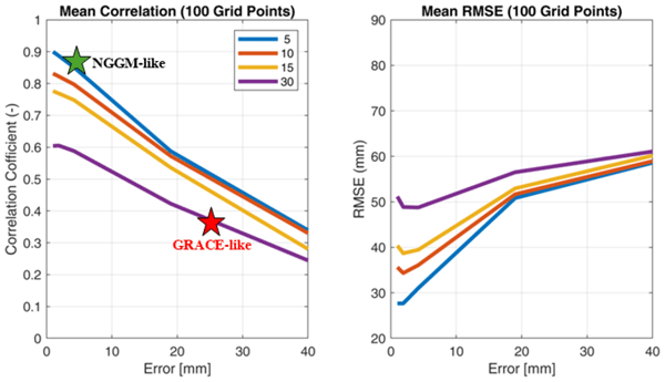
The ESA SING project demonstrates how the future satellite gravity missions NGGM and MAGIC will improve observations of continental water storage, oceans, glaciers, sea level, earthquakes, and climate change. Their more accurate, higher-resolution gravity measurements will enhance Earth system monitoring, improve climate and hazard assessments, and strengthen operational services for water management, disaster preparedness, and environmental decision-making.
Muhammad Usman Liaqat, Stefania Camici, Francesco Leopardi, Jaime Gaona, and Luca Brocca
Hydrol. Earth Syst. Sci., 30, 4969–4983, https://doi.org/10.5194/hess-30-4969-2026, https://doi.org/10.5194/hess-30-4969-2026, 2026
Short summary
Short summary
Tracking land water storage helps examine extreme events and manage water resources. GRACE (Gravity Recovery and Climate Experiment) missions observe changes, but coarse resolution in space and time challenges effective management. New gravity mission called MAGIC (Mass Change And Geosciences International Constellation) can offers better accuracy. This study tested MAGIC’s potential to estimate precipitation using the SM2RAIN approach. Results show SM2RAIN works well with frequent, accurate data but deteriorates with noisy/sparse data, emphasizing the need for precise gravity missions.
Pierre Laluet, Jacopo Dari, Louise Busschaert, Zdenko Heyvaert, Gabrielle De Lannoy, Pia Langhans, Sara Modanesi, Christian Massari, Luca Brocca, Carla Saltalippi, Renato Morbidelli, Clément Albergel, and Wouter Dorigo
Earth Syst. Sci. Data, 18, 4833–4853, https://doi.org/10.5194/essd-18-4833-2026, https://doi.org/10.5194/essd-18-4833-2026, 2026
Short summary
Short summary
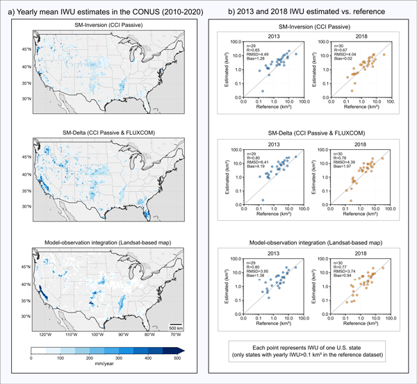
We developed a long-term dataset collection of irrigation water use based on about two decades of satellite observations, three distinct approaches, and many input datasets. The collection provides monthly estimates for major agricultural regions and helps describe how irrigation varies across locations, seasons, and years. It offers a foundation for improving how irrigation is quantified, compared across methods, and integrated into large-scale hydrological and climate studies.
Clay Harrison, Sebastian Hahn, Roland Lindorfer, Thomas Melzer, Raffaele Crapolicchio, and Wolfgang Wagner
ISPRS Ann. Photogramm. Remote Sens. Spatial Inf. Sci., XI-3-2026, 411–417, https://doi.org/10.5194/isprs-annals-XI-3-2026-411-2026, https://doi.org/10.5194/isprs-annals-XI-3-2026-411-2026, 2026
Sebastian Hahn, Thomas Melzer, and Wolfgang Wagner
Earth Syst. Sci. Data, 18, 4393–4423, https://doi.org/10.5194/essd-18-4393-2026, https://doi.org/10.5194/essd-18-4393-2026, 2026
Short summary
Short summary
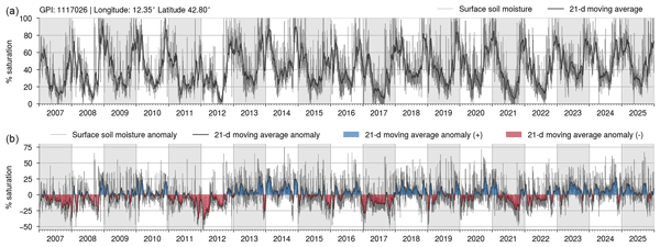
This article presents the latest version of the H SAF (Satellite Application Facility on Support to Operational Hydrology and Water Management) ASCAT (Advanced Scatterometer) SSM (surface soil moisture) datasets, unifying the NRT (near real-time) product with the historical offline data record. This release now applies the latest retrieval algorithm to both data streams, creating a consistent and unified data stream that is further complemented by a new, high-resolution 6.25 km sampling SSM product. The H SAF ASCAT SSM datasets are publicly available from https://hsaf.meteoam.it.
Francesco Avanzi, Hans Lievens, Michael Matiu, Paolo Filippucci, Oscar M. Baez Villanueva, Simone Gabellani, Fabio Delogu, Lorenzo Alfieri, Andrea Libertino, Pere Quintana-Seguì, Diego G. Miralles, Luca Brocca, Christian Massari, and Gabriëlle J. M. De Lannoy
EGUsphere, https://doi.org/10.5194/egusphere-2026-2851, https://doi.org/10.5194/egusphere-2026-2851, 2026
Short summary
Short summary
We developed a new system to map and monitor snow and stored water across large mountain regions using satellite data and computer simulations. Tested in four major European river basins, the system reproduced snow conditions with high accuracy and realistically captured how snow changes with elevation. Because it does not rely on ground measurements, it can help provide consistent information on snow-water resources worldwide, supporting water management and climate adaptation.
Ather Abbas, Yuan Yang, Ming Pan, Yves Tramblay, Chaopeng Shen, Haoyu Ji, Solomon H. Gebrechorkos, Florian Pappenberger, JongCheol Pyo, Dapeng Feng, George Huffman, Phu Nguyen, Christian Massari, Luca Brocca, Jackson Tan, and Hylke E. Beck
Hydrol. Earth Syst. Sci., 30, 3399–3423, https://doi.org/10.5194/hess-30-3399-2026, https://doi.org/10.5194/hess-30-3399-2026, 2026
Short summary
Short summary
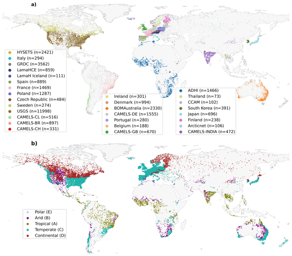
Our study evaluated 24 precipitation datasets using a hydrological model at global scale to assess their suitability and accuracy. We found that MSWEP (Multi-Source Weighted-Ensemble Precipitation) V2.8 excels due to its ability to integrate data from multiple sources, while others, such as IMERG (Integrated Multi-satellitE Retrievals for Global Precipitation Mission) and GDAS (Global Data Assimilation System), demonstrated strong regional performances. This research assists in selecting the appropriate dataset for applications in water resource management, hazard assessment, agriculture, and environmental monitoring.
Peyman Afrasiabikia, Atefeh Parvaresh Rizi, and Luca Brocca
ISPRS Ann. Photogramm. Remote Sens. Spatial Inf. Sci., X-4-W8-2025, 33–38, https://doi.org/10.5194/isprs-annals-X-4-W8-2025-33-2026, https://doi.org/10.5194/isprs-annals-X-4-W8-2025-33-2026, 2026
Ehsan Modiri, Oldrich Rakovec, Pallav Kumar Shrestha, Almudena García-García, Leandro Avila, Katie Blackford, Elizabeth Cooper, Bram Droppers, Paolo Filippucci, Milan Fischer, Matěj Orság, Pietro Stradiotti, Luca Brocca, Douglas B. Clark, Wouter Dorigo, Stefan Kollet, Jian Peng, Niko Wanders, and Luis Samaniego
EGUsphere, https://doi.org/10.5194/egusphere-2026-1012, https://doi.org/10.5194/egusphere-2026-1012, 2026
Short summary
Short summary
Drought impacts water supply, agriculture, and ecosystems, yet hydrological models often disagree on when and where drought occurs. This study tested whether satellite observations can improve how models represent soil moisture drought in the Rhine River basin. Using several models and major drought events, we show that satellite data improve spatial realism and reveal important differences among models, helping to better understand uncertainty in drought monitoring and early warning.
Dariela A. Vázquez Rodríguez, Pavan Muguda Sanjeevamurthy, Wolfgang Wagner, Sebastian Hahn, and Fabiola D. Yépez-Rincón
ISPRS Ann. Photogramm. Remote Sens. Spatial Inf. Sci., X-3-W3-2025, 101–108, https://doi.org/10.5194/isprs-annals-X-3-W3-2025-101-2026, https://doi.org/10.5194/isprs-annals-X-3-W3-2025-101-2026, 2026
Paolo Filippucci, Luca Brocca, Luca Ciabatta, Hamidreza Mosaffa, Francesco Avanzi, and Christian Massari
Earth Syst. Sci. Data, 17, 5221–5258, https://doi.org/10.5194/essd-17-5221-2025, https://doi.org/10.5194/essd-17-5221-2025, 2025
Short summary
Short summary
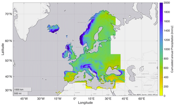
Accurate rainfall data is essential, yet measuring daily precipitation worldwide is challenging. This research presents HYdroclimatic PERformance-enhanced Precipitation (HYPER-P), a dataset combining satellite, ground, and reanalysis data to estimate precipitation at a 1 km scale from 2000 to 2022. HYPER-P improves accuracy, especially in areas with few rain gauges. This dataset supports scientists and decision-makers in understanding and managing water resources more effectively.
Jaime Gaona, Davide Bavera, Guido Fioravanti, Sebastian Hahn, Pietro Stradiotti, Paolo Filippucci, Stefania Camici, Luca Ciabatta, Hamidreza Mosaffa, Silvia Puca, Nicoletta Roberto, and Luca Brocca
Hydrol. Earth Syst. Sci., 29, 3865–3888, https://doi.org/10.5194/hess-29-3865-2025, https://doi.org/10.5194/hess-29-3865-2025, 2025
Short summary
Short summary
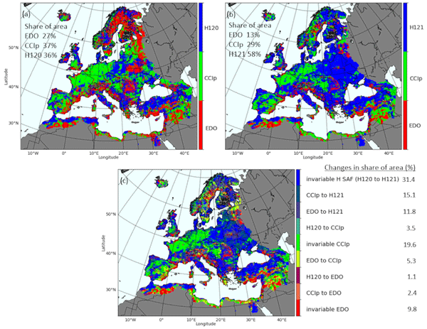
Soil moisture is crucial for the water cycle since it is at the front line of drought. Satellite, model and in situ data help identify soil moisture stress but are challenged by data uncertainties. This study evaluates trends and data coherence of common active/passive microwave sensors and model-based soil moisture data against in situ stations across Europe from 2007 to 2022. Data reliability is increasing, but combining data types improves soil moisture monitoring capabilities.
Ling Zhang, Yanhua Xie, Xiufang Zhu, Qimin Ma, and Luca Brocca
Earth Syst. Sci. Data, 16, 5207–5226, https://doi.org/10.5194/essd-16-5207-2024, https://doi.org/10.5194/essd-16-5207-2024, 2024
Short summary
Short summary
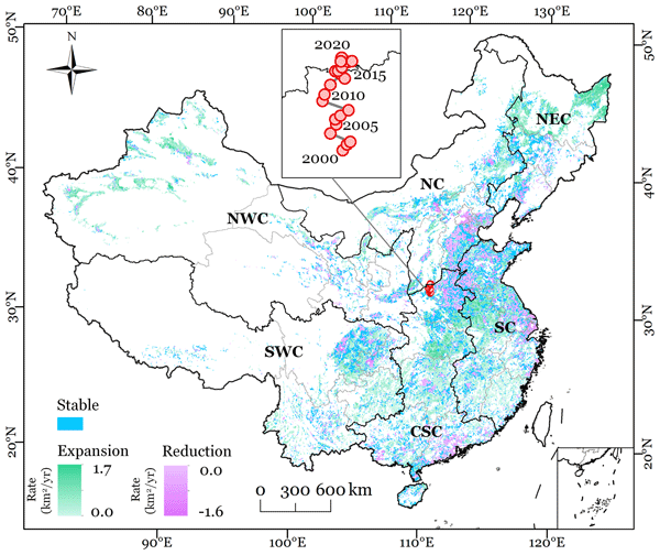
This study presented new annual maps of irrigated cropland in China from 2000 to 2020 (CIrrMap250). These maps were developed by integrating remote sensing data, irrigation statistics and surveys, and an irrigation suitability map. CIrrMap250 achieved high accuracy and outperformed currently available products. The new irrigation maps revealed a clear expansion of China’s irrigation area, with the majority (61%) occurring in the water-unsustainable regions facing severe to extreme water stress.
Jacopo Dari, Paolo Filippucci, and Luca Brocca
Hydrol. Earth Syst. Sci., 28, 2651–2659, https://doi.org/10.5194/hess-28-2651-2024, https://doi.org/10.5194/hess-28-2651-2024, 2024
Short summary
Short summary
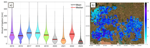
We have developed the first operational system (10 d latency) for estimating irrigation water use from accessible satellite and reanalysis data. As a proof of concept, the method has been implemented over an irrigated area fed by the Kakhovka Reservoir, in Ukraine, which collapsed on June 6, 2023. Estimates for the period 2015–2023 reveal that, as expected, the irrigation season of 2023 was characterized by the lowest amounts of irrigation.
Søren Julsgaard Kragh, Jacopo Dari, Sara Modanesi, Christian Massari, Luca Brocca, Rasmus Fensholt, Simon Stisen, and Julian Koch
Hydrol. Earth Syst. Sci., 28, 441–457, https://doi.org/10.5194/hess-28-441-2024, https://doi.org/10.5194/hess-28-441-2024, 2024
Short summary
Short summary
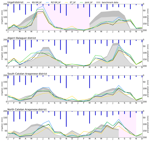
This study provides a comparison of methodologies to quantify irrigation to enhance regional irrigation estimates. To evaluate the methodologies, we compared various approaches to quantify irrigation using soil moisture, evapotranspiration, or both within a novel baseline framework, together with irrigation estimates from other studies. We show that the synergy from using two equally important components in a joint approach within a baseline framework yields better irrigation estimates.
J. Zhao, F. Roth, B. Bauer-Marschallinger, W. Wagner, M. Chini, and X. X. Zhu
ISPRS Ann. Photogramm. Remote Sens. Spatial Inf. Sci., X-1-W1-2023, 911–918, https://doi.org/10.5194/isprs-annals-X-1-W1-2023-911-2023, https://doi.org/10.5194/isprs-annals-X-1-W1-2023-911-2023, 2023
Florian Roth, Bernhard Bauer-Marschallinger, Mark Edwin Tupas, Christoph Reimer, Peter Salamon, and Wolfgang Wagner
Nat. Hazards Earth Syst. Sci., 23, 3305–3317, https://doi.org/10.5194/nhess-23-3305-2023, https://doi.org/10.5194/nhess-23-3305-2023, 2023
Short summary
Short summary
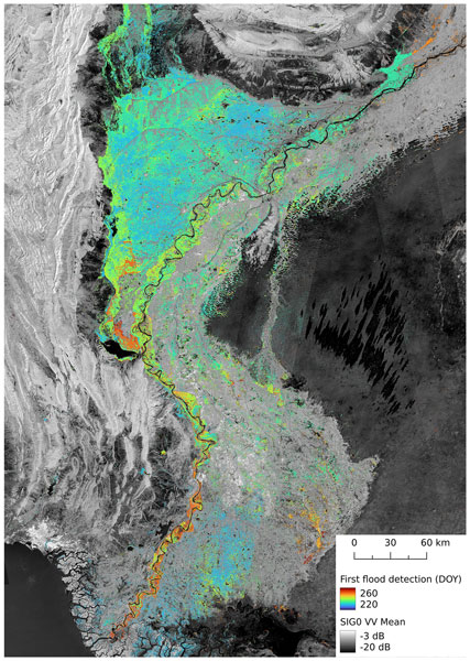
In August and September 2022, millions of people were impacted by a severe flood event in Pakistan. Since many roads and other infrastructure were destroyed, satellite data were the only way of providing large-scale information on the flood's impact. Based on the flood mapping algorithm developed at Technische Universität Wien (TU Wien), we mapped an area of 30 492 km2 that was flooded at least once during the study's time period. This affected area matches about the total area of Belgium.
Jacopo Dari, Luca Brocca, Sara Modanesi, Christian Massari, Angelica Tarpanelli, Silvia Barbetta, Raphael Quast, Mariette Vreugdenhil, Vahid Freeman, Anaïs Barella-Ortiz, Pere Quintana-Seguí, David Bretreger, and Espen Volden
Earth Syst. Sci. Data, 15, 1555–1575, https://doi.org/10.5194/essd-15-1555-2023, https://doi.org/10.5194/essd-15-1555-2023, 2023
Short summary
Short summary
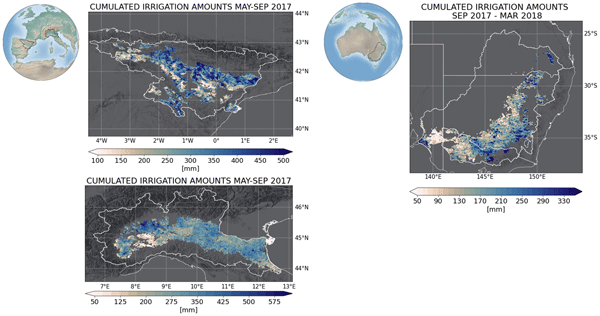
Irrigation is the main source of global freshwater consumption. Despite this, a detailed knowledge of irrigation dynamics (i.e., timing, extent of irrigated areas, and amounts of water used) are generally lacking worldwide. Satellites represent a useful tool to fill this knowledge gap and monitor irrigation water from space. In this study, three regional-scale and high-resolution (1 and 6 km) products of irrigation amounts estimated by inverting the satellite soil moisture signals are presented.
Kunlong He, Wei Zhao, Luca Brocca, and Pere Quintana-Seguí
Hydrol. Earth Syst. Sci., 27, 169–190, https://doi.org/10.5194/hess-27-169-2023, https://doi.org/10.5194/hess-27-169-2023, 2023
Short summary
Short summary
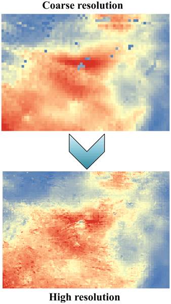
In this study, we developed a soil moisture-based precipitation downscaling (SMPD) method for spatially downscaling the GPM daily precipitation product by exploiting the connection between surface soil moisture and precipitation according to the soil water balance equation. Based on this physical method, the spatial resolution of the daily precipitation product was downscaled to 1 km and the SMPD method shows good potential for the development of the high-resolution precipitation product.
Sara Modanesi, Christian Massari, Michel Bechtold, Hans Lievens, Angelica Tarpanelli, Luca Brocca, Luca Zappa, and Gabriëlle J. M. De Lannoy
Hydrol. Earth Syst. Sci., 26, 4685–4706, https://doi.org/10.5194/hess-26-4685-2022, https://doi.org/10.5194/hess-26-4685-2022, 2022
Short summary
Short summary
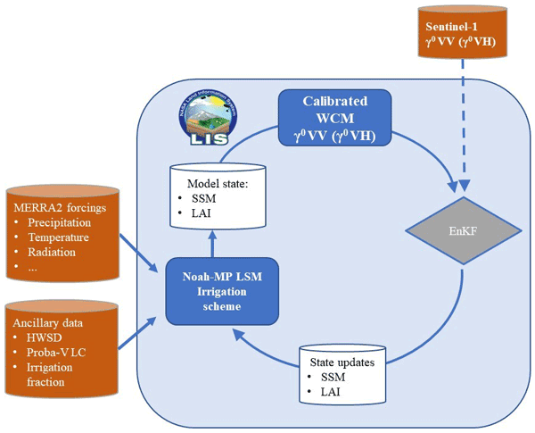
Given the crucial impact of irrigation practices on the water cycle, this study aims at estimating irrigation through the development of an innovative data assimilation system able to ingest high-resolution Sentinel-1 radar observations into the Noah-MP land surface model. The developed methodology has important implications for global water resource management and the comprehension of human impacts on the water cycle and identifies main challenges and outlooks for future research.

Stefania Camici, Gabriele Giuliani, Luca Brocca, Christian Massari, Angelica Tarpanelli, Hassan Hashemi Farahani, Nico Sneeuw, Marco Restano, and Jérôme Benveniste
Geosci. Model Dev., 15, 6935–6956, https://doi.org/10.5194/gmd-15-6935-2022, https://doi.org/10.5194/gmd-15-6935-2022, 2022
Short summary
Short summary
This paper presents an innovative approach, STREAM (SaTellite-based Runoff Evaluation And Mapping), to derive daily river discharge and runoff estimates from satellite observations of soil moisture, precipitation, and terrestrial total water storage anomalies. Potentially useful for multiple operational and scientific applications, the added value of the STREAM approach is the ability to increase knowledge on the natural processes, human activities, and their interactions on the land.
M. Tupas, C. Navacchi, F. Roth, B. Bauer-Marschallinger, F. Reuß, and W. Wagner
Int. Arch. Photogramm. Remote Sens. Spatial Inf. Sci., XLVIII-4-W1-2022, 495–502, https://doi.org/10.5194/isprs-archives-XLVIII-4-W1-2022-495-2022, https://doi.org/10.5194/isprs-archives-XLVIII-4-W1-2022-495-2022, 2022
Lorenzo Alfieri, Francesco Avanzi, Fabio Delogu, Simone Gabellani, Giulia Bruno, Lorenzo Campo, Andrea Libertino, Christian Massari, Angelica Tarpanelli, Dominik Rains, Diego G. Miralles, Raphael Quast, Mariette Vreugdenhil, Huan Wu, and Luca Brocca
Hydrol. Earth Syst. Sci., 26, 3921–3939, https://doi.org/10.5194/hess-26-3921-2022, https://doi.org/10.5194/hess-26-3921-2022, 2022
Short summary
Short summary
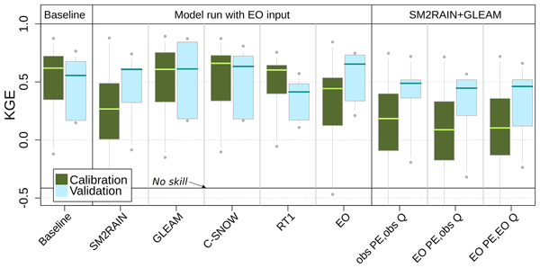
This work shows advances in high-resolution satellite data for hydrology. We performed hydrological simulations for the Po River basin using various satellite products, including precipitation, evaporation, soil moisture, and snow depth. Evaporation and snow depth improved a simulation based on high-quality ground observations. Interestingly, a model calibration relying on satellite data skillfully reproduces observed discharges, paving the way to satellite-driven hydrological applications.

Ashwini Petchiappan, Susan C. Steele-Dunne, Mariette Vreugdenhil, Sebastian Hahn, Wolfgang Wagner, and Rafael Oliveira
Hydrol. Earth Syst. Sci., 26, 2997–3019, https://doi.org/10.5194/hess-26-2997-2022, https://doi.org/10.5194/hess-26-2997-2022, 2022
Short summary
Short summary
This study investigates spatial and temporal patterns in the incidence angle dependence of backscatter from the ASCAT C-band scatterometer and relates those to precipitation, humidity, and radiation data and GRACE equivalent water thickness in ecoregions in the Amazon. The results show that the ASCAT data record offers a unique perspective on vegetation water dynamics exhibiting sensitivity to moisture availability and demand and phenological change at interannual, seasonal, and diurnal scales.
Paolo Filippucci, Luca Brocca, Raphael Quast, Luca Ciabatta, Carla Saltalippi, Wolfgang Wagner, and Angelica Tarpanelli
Hydrol. Earth Syst. Sci., 26, 2481–2497, https://doi.org/10.5194/hess-26-2481-2022, https://doi.org/10.5194/hess-26-2481-2022, 2022
Short summary
Short summary
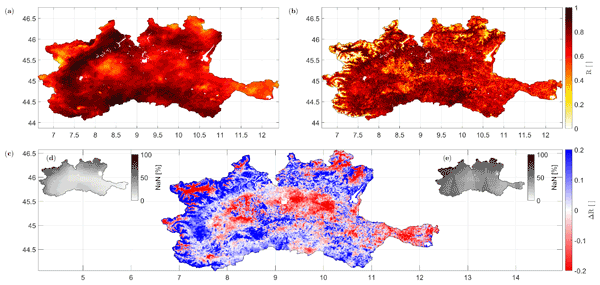
A high-resolution (1 km) rainfall product with 10–30 d temporal resolution was obtained starting from SM data from Sentinel-1. Good performances are achieved using observed data (gauge and radar) over the Po River Valley, Italy, as a benchmark. The comparison with a product characterized by lower spatial resolution (25 km) highlights areas where the high spatial resolution of Sentinel-1 has great benefits. Possible applications include water management, agriculture and index-based insurances.
Wouter Dorigo, Irene Himmelbauer, Daniel Aberer, Lukas Schremmer, Ivana Petrakovic, Luca Zappa, Wolfgang Preimesberger, Angelika Xaver, Frank Annor, Jonas Ardö, Dennis Baldocchi, Marco Bitelli, Günter Blöschl, Heye Bogena, Luca Brocca, Jean-Christophe Calvet, J. Julio Camarero, Giorgio Capello, Minha Choi, Michael C. Cosh, Nick van de Giesen, Istvan Hajdu, Jaakko Ikonen, Karsten H. Jensen, Kasturi Devi Kanniah, Ileen de Kat, Gottfried Kirchengast, Pankaj Kumar Rai, Jenni Kyrouac, Kristine Larson, Suxia Liu, Alexander Loew, Mahta Moghaddam, José Martínez Fernández, Cristian Mattar Bader, Renato Morbidelli, Jan P. Musial, Elise Osenga, Michael A. Palecki, Thierry Pellarin, George P. Petropoulos, Isabella Pfeil, Jarrett Powers, Alan Robock, Christoph Rüdiger, Udo Rummel, Michael Strobel, Zhongbo Su, Ryan Sullivan, Torbern Tagesson, Andrej Varlagin, Mariette Vreugdenhil, Jeffrey Walker, Jun Wen, Fred Wenger, Jean Pierre Wigneron, Mel Woods, Kun Yang, Yijian Zeng, Xiang Zhang, Marek Zreda, Stephan Dietrich, Alexander Gruber, Peter van Oevelen, Wolfgang Wagner, Klaus Scipal, Matthias Drusch, and Roberto Sabia
Hydrol. Earth Syst. Sci., 25, 5749–5804, https://doi.org/10.5194/hess-25-5749-2021, https://doi.org/10.5194/hess-25-5749-2021, 2021
Short summary
Short summary
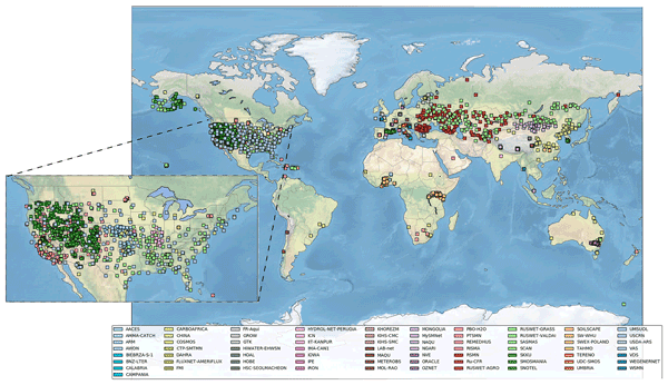
The International Soil Moisture Network (ISMN) is a community-based open-access data portal for soil water measurements taken at the ground and is accessible at https://ismn.earth. Over 1000 scientific publications and thousands of users have made use of the ISMN. The scope of this paper is to inform readers about the data and functionality of the ISMN and to provide a review of the scientific progress facilitated through the ISMN with the scope to shape future research and operations.
Daniele Masseroni, Stefania Camici, Alessio Cislaghi, Giorgio Vacchiano, Christian Massari, and Luca Brocca
Hydrol. Earth Syst. Sci., 25, 5589–5601, https://doi.org/10.5194/hess-25-5589-2021, https://doi.org/10.5194/hess-25-5589-2021, 2021
Short summary
Short summary
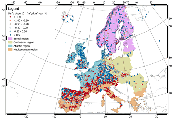
We evaluate 63 years of changes in annual streamflow volume across Europe, using a data set of more than 3000 stations, with a special focus on the Mediterranean basin. The results show decreasing (increasing) volumes in the southern (northern) regions. These trends are strongly consistent with the changes in temperature and precipitation.
Cited articles
Akaike, H.: New look at the statistical model identification, IEEE Transactions on Automatic Control, AC-19, 716–723, 1974.
Bagarello, V. and Ferro, V.: Plot-scale measurement of soil erosion at the experimental area of Sparacia (southern Italy), Hydrol. Process., 18, 141–157, 2004.
Bagarello, V., Di Piazza, G. V., Ferro, V., and Giordano, G.: Predicting unit soil loss in Sicily, south Italy, Hydrol. Process., 22, 586–595, 2008.
Bagarello, V., Ferro, V., and Giordano, G.: Testing alternative erosivity indices to predict event soil loss from bare plots in southern Italy, Hydrol. Process., 24, 789–797, 2010.
Bagarello, V., Di Stefano, C., Ferro, V., Kinnell, P. I. A., Pampalone, V., Porto, P., and Todisco, F.: Predicting soil loss on moderate scope using an empirical model for sediment concentration, J. Hydrol., 400, 267–273, 2011.
Bagarello, V., Di Stefano, C., Ferro, V., Giordano, G., Iovino, M., and Pampalone, V.: Estimating the USLE soil erodibility factor in Sicily, south Italy, Appl. Eng. Agric., 28, 199–206, 2012.
Bagarello, V., Ferro, V., Giordano, G., Mannocchi, F., Todisco, F., and Vergni, L.: Predicting event soil loss form bare plots at two Italian sites, Catena, 109, 96–102, 2013.
Bagarello, V., Ferro, V., and Pampalone, V.: Testing assumptions and procedures to empirically predict bare plot soil loss in a Mediterranean environment, Hydrol. Process., https://doi.org/10.1002/hyp.10382, 2014.
Brocca, L., Melone, F., and Moramarco, T.: On the estimation of antecedent wetness conditions in rainfall-runoff modelling, Hydrol. Process., 22, 629–642, 2008.
Brocca, L., Melone, F., Moramarco, T., and Singh, V. P.: Assimilation of observed soil moisture data in storm rainfall-runoff modelling, J. Hydrol. Eng., 14, 153–165, 2009.
Brocca, L., Melone, F., Moramarco, T., Wagner, W., and Hasenauer, S.: ASCAT Soil Wetness Index validation through in-situ and modeled soil moisture data in central Italy, Remote Sens. Environ., 114, 2745–2755, 2010.
Brocca, L., Melone, F., and Moramarco, T.: Distributed rainfall-runoff modeling for flood frequency estimation and flood forecastig, Hydrol. Process., 25, 2801–2813, 2011a.
Brocca, L., Hasenauer, S., Lacava, T., Melone, F., Moramarco, T., Wagner, W., Dorigo, W., Matgen, P., Martínez-Fernández, J., Llorens, P., Latron, J., Martin, C., and Bittelli, M.: Soil moisture estimation through ASCAT and AMSR-E sensors: an intercomparison and validation study across Europe, Remote Sens. Environ,, 115, 3390–3408, 2011b.
Brocca, L., Ponziani, F., Moramarco, T., Melone, F., Berni, N., and Wagner, W.: Improving landslide forecasting using ASCAT-derived soil moisture data: A case study of the Torgiovannetto landslide in central Italy, Remote Sens., 4, 1232–1244, 2012.
Brocca, L., Zucco, G., Moramarco, T., and Morbidelli, R.: Developing and testing a long-term soil moisture dataset at the catchment scale, J. Hydrol., 490, 144–151, 2013.
Brocca, L., Zucco, G., Mittelbach, H., Moramarco, T., and Seneviratne, S. I.: Absolute versus temporal anomaly and percent of saturation soil moisture spatial variability for six networks worldwide, Water Resour. Res., 50, 5560–5576, 2014a.
Brocca, L., Camici, S., Melone, F., Moramarco, T., Martinez-Fernandez, J., Didon-Lescot, J.-F., and Morbidelli, R.: Improving the representation of soil moisture by using a semi-analytical infiltration model, Hydrol. Process., 28, 2103–2115, 2014b.
Burnham, K. P. and Anderson, D. R.: Model Selection and Multi-model Inference: A Practical Information-Theoretic Approach, Springer New York, 284–288, 2002.
Butzen, V., Seeger, M., Wirtz, S., Huemann, M., Mueller, C., Casper, M., and Ries, J. B.: Quantification of Hortonian overland flow generation and soil erosion in a Central European low mountain range using rainfall experiments, Catena, 113, 202–212, 2014.
Cerdà, A.: The influence of aspect and vegetation on seasonalchanges in erosion under rainfall simulation on a clay soil in Spain, Can. J. Soil Sci., 78, 321–330, 1998.
Di Stefano, C., Ferro, V., and Minacapilli, M.: Testing the SEDD model in Sicilian basins IAHS Publ., 292, 152–161, 2005.
Doorenbos, J. and Pruitt, W. O.: Background and development of methods to predict reference crop evapotranspiration (ETo), FAO-ID-24, Appendix II, 108–119, 1977.
Famiglietti, J. S. and Wood, E. F.: Multiscale modeling of spatially variable water and energy balance processes, Water Resour. Res., 11, 3061–3078, 1994.
Flanagan, D. C., Gilley, J. E., and Franti, T. G.: Water erosion prediction project (WEPP): development history, model capabilities and future enhancements, T. ASABE, 50, 1603–1612, 1995.
Foster, G. R., Lombardi, F., and Moldenhauer, W. C.: Evaluation of rainfall-runoff erosivity factors for individual storms, T. ASAE, 25, 124–129, 1982.
Foster, G. R., Toy, T. E., and Renard, K. G.: Comparison of the USLE, RUSLE1.06 and RUSLE2 for application to highly disturbed lands, edited by: Renard, K. G., Mc Ilroy, S. A., Gburek, W. J., Cranfield, H. E., and Scott, R. L., in: First Interagency Conference on Research in Watersheds, October 27–30, USDA, 2003.
Gao, G. Y., Fu, B. J., Lü, Y. H., Liu, Y., Wang, S., and Zhou, J.: Coupling the modified SCS-CN and RUSLE models to simulate hydrological effects of restoring vegetation in the Loess Plateau of China, Hydrol. Earth Syst. Sci., 16, 2347–2364, https://doi.org/10.5194/hess-16-2347-2012, 2012.
Huang, C.: Sediment regimes under different slope and surface hydrologic conditions, Soil Sci. Soc. Am. J., 62, 423–430, 1998.
Kinnell, P. I. A.: Runoff ratio as a factor in the empirical modeling of soil erosion by individual rainstorms, Aus. J. Soil Res., 35, 1–13, 1997.
Kinnell P. I. A.: Runoff dependent erosivity and slope length factors suitable for modeling annual erosion using the Universal Soil Loss Equation, Hydrol. Process. 21, 2681–2689, 2007.
Kinnell, P. I. A.: Event soil loss, runoff and the Universal Soil Loss Equation family of models: A review, J. Hydrol., 385, 384–397, 2010.
Kinnell, P. I. A.: Modelling event soil losses using QREI30 index with RUSLE2, Hydrol. Process., 28, 2761–2771, 2014.
Kinnell, P. I. A.: Accounting for the influence of runoff on event soil erodibilities associated with the EI30 index in RUSLE2, Hydrol. Process., 29, 1397–1405, 2015.
Kinnell, P. I. A. and Risse, L. M.: USLE-M: empirical modeling rainfall erosion through runoff and sediment concentration, Soil Sci. Soc. Am. J., 62, 1667–1672, 1998.
Lacava, T., Matgen, P., Brocca, L., Bittelli, M., and Moramarco, T.: A first assessment of the SMOS soil moisture product with in-situ and modelled data in Italy and Luxembourg, IEEE Trans. Geosci. Remote Sens., 50, 1612–1622, 2012.
Larson, W. E., Lindstrom, M. J., and Schumacher, T. E.: The role of severe storms in soil erosion: a problem needing consideration, J. Soil Water Conserv., 52, 90–95, 1997.
Leh, M., Bajwa, S., and Chaubey, I.: Impact of land use change on erosion risk: an integrated remote sensing geopraphic information system and modeling methodology, Land Degrad. Develop., 24, 409-421, 2013.
Ligonja, P. J. and Shrestha, R. P.: Soil erosion assessment in Kondoa eroded area in Tanzania using Universal Soil Loss Equation, geographic information systems and socioeconomic approach, Land Degrad. Develop., https://doi.org/10.1002/ldr.2215, 2013.
Mannocchi, F., Todisco, F., Vergni, L., and Vinci, A.: Calibrazione di un sistema di misura di erosione idrica a scala di parcella, in: Atti del 31° Convegno Nazionale di Idraulica e Costruzioni Idrauliche, Morlacchi Editore, Perugia, 1–8, 2008.
Morgan, R. P. C.: Soil Erosion and Conservation, Blackwell Publishing, Malden, MA, USA, 3rd edition, 2005.
Morgan, R. P. C. and Nearing, M. A.: Soil erosion models: present and future, in: Proceedings of the Third International Congress "Man and Soil at the Third Millennium", edited by: Rubio, J. L., Asins, S., Andreu, V., de Paz, J. M., and Gimeno, E., European Society for Soil Conservation, Valencia, Spain, 28 March–1 April, 145–164, 2000.
Nagin, J. B. and Roeder, K. A.: SAS procedure based on mixture models for estimating developmental trajectories. Sociol. Meth. Res., 29, 374–393, 2001.
Nearing, M. A.: A single continuous function for slope steepness influence on soil loss, Soil Sci. Soc. Am. J., 61, 917–919, 1997.
Parsons, A. J., Brazier, R. E., Wainwright, J., and Powell, D. M.: Scale relationships in hillslope runoff and erosion, Earth Surf. Process. Landf., 31, 1384–1393, 2006.
Rejman, J., Usowicz, B., and Dçbicki, R.: Source of errors in predicting silt soil erodibility withusle, Pol. J. Soil Sci., 32, 20–22, 1999.
Renard, K. G., Foster, G. R., Weesies, G. A., McCool, D. K., and Ynder, D. C.: Predicitng Soil Erosion By Water: A Guide To Conservationvation Planning With the Revised Universal Soil Loss Equation (RUSLE). United States Department of Agriculture-USDA. Agriculture Handbook Number 703, Washington, D.C., USA, 1997.
Risse, L. M., Nearing, M. A., Nicks, A. D., and Laflen, J. M.: Error assessment in the Universal Soil Loss Equation, Soil Sci. Soc. Am. J., 57, 825–833, 1993.
Soil Survey Staff: Keys to Soil Taxonomy, USDA-Natural Resources Conservation Service, Washington, DC, USA, 10th edition, 2006.
Tiwari, A. K., Risse, L. M., and Nearing, M.: Evaluation of WEPP and its comparison with USLE and RUSLE, T. ASAE, 43, 1129–1135, 2000.
Todisco, F.: The internal structure of erosive and non-erosive storm events for interpretation of erosive processes and rainfall simulation, J. Hydrol., 519, 3651–3663, 2014.
Todisco, F., Mannocchi, F., Vergni, L, and Vinci A.: Plot scale measurements of rainfall erosion losses in central Italy, IAHS Publ., 327, 324–330, 2009.
Todisco, F., Vergni, L., Mannocchi, F., and Bomba, C.: Calibration of the soil loss measurement at the Masse experimental station, Catena, 91, 4–9, 2012a.
Todisco, F., Brocca, L., Mannocchi, F., Melone, F., and Moramarco, T.: Utilizzo di modellistica idrologica in continuo accoppiata ad un modello USLE modificato per la previsione della perdita di suolo parcellare in Umbria, Quaderni di Idronomia Montana, 30, 353–362, 2012b.
Vrieling, A., Hoedjes, J. C. B., and van der Velde, M.: Towards large-scale monitoring of soil erosion in Africa: Accounting for the dynamics of rainfall erosivity, Glob. Planet. Change, 115, 33–43, 2014.
Wagner, W., Lemoine, G., and Rott, H.: A method for estimating soil moisture from ERS scatterometer and soil data, Remote Sens. Environ., 70, 191–207, 1999.
Wagner, W., Hahn, S., Kidd, R., Melzer, T., Bartalis, Z., Hasenauer, S., Figa, J., de Rosnay, P., Jann, A., Schneider, S., Komma, J., Kubu, G., Brugger, K., Aubrecht, C., Zuger, J., Gangkofner, U., Kienberger, S., Brocca, L., Wang, Y., Bloeschl, G., Eitzinger, J., Steinnocher, K., Zeil, P., and Rubel, F: The ASCAT Soil Moisture Product: A Review of its Specifications, Validation Results, and Emerging Applications, Meteorol. Z., 22, 5–33, 2013.
Williams, J. R.: Sediment-yield prediction with universal equation using runoff energy factor. in: Present and Prospective Technology for Predicting Sediment Yield and Sources, USDA, Washington, DC, USA, 244–252, 1975.
Williams, J. R. and Berndt, H. D.: Sediment yield prediction based on watershed hydrology, T. ASAE, 20, 1100–1104, 1977.
Williams, J. R., Jones, C. A., and Dyke, P. T.:. A modeling approach to determining the relationship between erosion and productivity, T. ASAE, 27, 129–144, 1984a.
Williams, J. R., Jones, C. A., and Dyke, P. T.: The EPIC model and its application, in: Proceedings of the International Symposium on minimum data sets for agrotechnology transfer, 21–26 March, 1983, ICRISAT Center, India, 1984b.
Williams, J. W., Izaurralde, R. C., and Steglich, E. M.: Agricultural Policy/Environmental Extender model theoretical documentation, BRC Report #2008-17, Blackland Research and Extension Center, Temple, TX, USA, 2008.
Wischmeier, W. H. and Smith, D. D.: Predicting rainfall-erosion losses – A guide to conservation planning, Agric. Handb. 537, USDA, 1978.
Short summary
We developed a new formulation of USLE, named Soil Moisture for Erosion (SM4E), that directly incorporates soil moisture information. SM4E is applied here by using modeled data and satellite observations obtained from the Advanced SCATterometer (ASCAT). SM4E is found to outperform USLE and USLE-MM models in silty–clay soil in central Italy. Through satellite data, there is the potential of applying SM4E for large-scale monitoring and quantification of the soil erosion process.
We developed a new formulation of USLE, named Soil Moisture for Erosion (SM4E), that directly...


