
Articles | Volume 30, issue 14
https://doi.org/10.5194/hess-30-4481-2026
© Author(s) 2026. This work is distributed under
the Creative Commons Attribution 4.0 License.
the Creative Commons Attribution 4.0 License.
https://doi.org/10.5194/hess-30-4481-2026
© Author(s) 2026. This work is distributed under
the Creative Commons Attribution 4.0 License.
the Creative Commons Attribution 4.0 License.
Research article
| 
17 Jul 2026
Research article |
| 17 Jul 2026
| 17 Jul 2026
Climate and landscape jointly control European streamflow behaviour

Department of Water Management, Faculty of Civil Engineering and Geosciences, Delft University of Technology, Delft, the Netherlands
Thiago V. M. do Nascimento
Eawag: Swiss Federal Institute of Aquatic Science and Technology, Dübendorf, Switzerland
Department of Geography, University of Zurich, Zurich, Switzerland
Ruud van der Ent
Department of Water Management, Faculty of Civil Engineering and Geosciences, Delft University of Technology, Delft, the Netherlands
Fabrizio Fenicia
Eawag: Swiss Federal Institute of Aquatic Science and Technology, Dübendorf, Switzerland
Markus Hrachowitz
Department of Water Management, Faculty of Civil Engineering and Geosciences, Delft University of Technology, Delft, the Netherlands
Related authors
Thiago V. M. do Nascimento, Julia Rudlang, Sebastian Gnann, Jan Seibert, Markus Hrachowitz, and Fabrizio Fenicia
Hydrol. Earth Syst. Sci., 29, 7173–7200, https://doi.org/10.5194/hess-29-7173-2025, https://doi.org/10.5194/hess-29-7173-2025, 2025
Short summary
Short summary
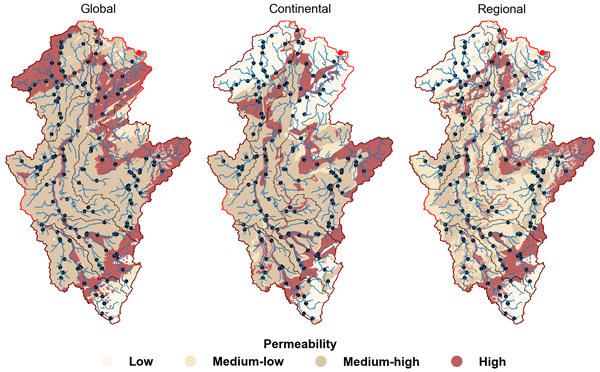
We show that geological maps with varying levels of detail may influence the identification of geology–streamflow relationships across European catchments at multiple scales. At the large scale, controls varied between basins, with no map consistently superior. At the intermediate and small scales, however, higher geological detail consistently strengthened correlations, particularly for baseflow signatures, with the regional map highlighting controls more consistent with process understanding.
Markus Hrachowitz and Roland Kaitna
EGUsphere, https://doi.org/10.5194/egusphere-2026-5589, https://doi.org/10.5194/egusphere-2026-5589, 2026
This preprint is open for discussion and under review for Hydrology and Earth System Sciences (HESS).
Short summary
Short summary
Debris flows are a mountain hazard, frequently predicted based on regional precipitation thresholds over larger areas. Based on debris flow and hydrological data, this study found that (1) channels are characterized by different debris flow timing due to differences in hydrology, (2) local thresholds provide more reliable debris flow predictions than regional ones and (3) precipitation thresholds were outperformed by thresholds that use hydrological variables such as snowmelt and channel flow.
Daniel Camilo Roman Quintero, Ruud van der Ent, Thom Bogaard, and Roberto Greco
Nat. Hazards Earth Syst. Sci., 26, 3723–3739, https://doi.org/10.5194/nhess-26-3723-2026, https://doi.org/10.5194/nhess-26-3723-2026, 2026
Short summary
Short summary
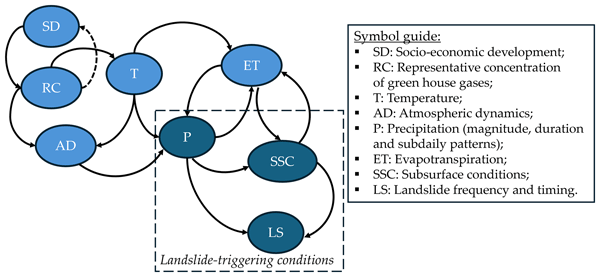
We present a framework linking projected rainfall with hydro-mechanical processes to assess landslide occurrences in a Mediterranean area, under RCP4.5 and RCP8.5. Despite generally drier soils, landslide frequency rises because shifts in the timing and intensity of rainfall, altering antecedent soil moisture during triggering events. This counterintuitive result highlights the importance of rainfall patterns in slope stability and informs climate-risk assessment and adaptation planning.
Muhammad Ibrahim, Markus Hrachowitz, Miriam Coenders-Gerrits, and Ruud van der Ent
EGUsphere, https://doi.org/10.5194/egusphere-2026-4226, https://doi.org/10.5194/egusphere-2026-4226, 2026
This preprint is open for discussion and under review for Hydrology and Earth System Sciences (HESS).
Short summary
Short summary
Root zone storage capacity is an important parameter in hydrological and land-surface models and is often estimated using the memory method rather than through model calibration. We evaluated the uncertainty associated with this widely used method across thousands of catchments worldwide. Our results show that uncertainty varies systematically with climate, while memory method estimates remain in close agreement with calibrated values, supporting the commonly used 20-year return period.

Daniel Klotz, Peter Miersch, Thiago V. M. do Nascimento, Fabrizio Fenicia, Corinna Frank, Martin Gauch, and Jakob Zscheischler
Earth Syst. Sci. Data, 18, 5485–5504, https://doi.org/10.5194/essd-18-5485-2026, https://doi.org/10.5194/essd-18-5485-2026, 2026
Short summary
Short summary
Data availability is central to hydrological science. It is the basis for advancing our understanding of hydrological processes, building prediction models, and anticipatory water management. We present a data-driven daily runoff reconstruction product for natural streamflow. We name it EARLS: European aggregated reconstruction for large-sample studies. The reconstructions represent daily simulations of natural streamflow across Europe and cover the period from 1953 to 2020.
Charlotte Braat, Stef Lhermitte, Marie Claire ten Veldhuis, Rolf Hut, and Ruud van der Ent
EGUsphere, https://doi.org/10.5194/egusphere-2026-1439, https://doi.org/10.5194/egusphere-2026-1439, 2026
This preprint is open for discussion and under review for Hydrology and Earth System Sciences (HESS).
Short summary
Short summary
Deforestation influences the regional and global water cycle. In this paper, deforestation data is combined with data that links rainfall to where this water evaporated. We estimate to what extent rainfall in the region is potentially impacted by deforestation elsewhere. We find that most regions are mostly impacted by deforestation outside of the region. We could not yet confirm a generic link with actual rainfall due to limitations, complex system interactions and region specific dynamics.
Hatice Türk, Christine Stumpp, Markus Hrachowitz, Peter Strauss, Günter Blöschl, and Michael Stockinger
Hydrol. Earth Syst. Sci., 30, 1053–1076, https://doi.org/10.5194/hess-30-1053-2026, https://doi.org/10.5194/hess-30-1053-2026, 2026
Short summary
Short summary
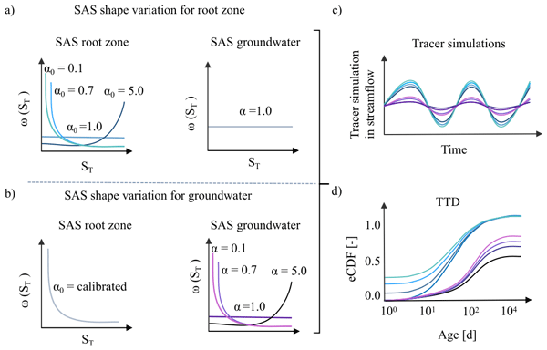
This study shows that streamflow isotope data in a catchment-scale isotope-based transport model were sufficient to isolate preferential flow in the unsaturated zone but insufficient to isolate the preferential release of young groundwater, as isotope signals were strongly damped by large passive groundwater storage. As a result, groundwater age-selection assumptions affected estimates of long transit times, making it difficult to quantify the fraction of stream water older than 100 days.
Cristina Prieto, Dmitri Kavetski, Fabrizio Fenicia, James Kirchner, David McInerney, Mark Thyer, and César Álvarez
EGUsphere, https://doi.org/10.5194/egusphere-2026-483, https://doi.org/10.5194/egusphere-2026-483, 2026
Short summary
Short summary
Hourly streamflow data are increasingly available and can improve streamflow predictions. We tested simple ways to describe uncertainty by transforming flow values and by accounting for how errors persist from hour to hour, using seven catchments in Spain, Switzerland and the United States. Simple transformations and short-term error memory improve the reliability of probabilistic predictions and help combine hourly results into longer time scales for practical operational contexts.
Franziska Clerc-Schwarzenbach and Thiago V. M. do Nascimento
Hydrol. Earth Syst. Sci., 30, 119–140, https://doi.org/10.5194/hess-30-119-2026, https://doi.org/10.5194/hess-30-119-2026, 2026
Short summary
Short summary
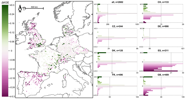
This study provides the first assessment of an European meteorological dataset (E-OBS) for hydrological applications. We compared the dataset to meteorological datasets developed at a country level, and tested how the different data influenced the simulation of streamflow with hydrological model. Our findings show that, despite some limitations, the European dataset offers a reasonable basis for hydrological modelling in most river catchments across Europe.
Thiago V. M. do Nascimento, Julia Rudlang, Sebastian Gnann, Jan Seibert, Markus Hrachowitz, and Fabrizio Fenicia
Hydrol. Earth Syst. Sci., 29, 7173–7200, https://doi.org/10.5194/hess-29-7173-2025, https://doi.org/10.5194/hess-29-7173-2025, 2025
Short summary
Short summary
We show that geological maps with varying levels of detail may influence the identification of geology–streamflow relationships across European catchments at multiple scales. At the large scale, controls varied between basins, with no map consistently superior. At the intermediate and small scales, however, higher geological detail consistently strengthened correlations, particularly for baseflow signatures, with the regional map highlighting controls more consistent with process understanding.
Nathalie Rombeek, Markus Hrachowitz, and Remko Uijlenhoet
Hydrol. Earth Syst. Sci., 29, 6715–6733, https://doi.org/10.5194/hess-29-6715-2025, https://doi.org/10.5194/hess-29-6715-2025, 2025
Short summary
Short summary
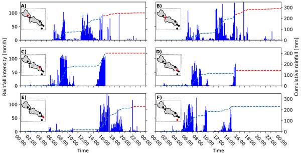
On 29 October 2024 Valencia (Spain) was struck by torrential rainfall, triggering devastating floods in this area. In this study, we quantify and describe the spatial and temporal structure of this rainfall event using personal weather stations (PWSs). These PWSs provide near real-time observations at a temporal resolution of ~5 min. This study shows the potential of PWSs for real-time rainfall monitoring and potentially flood early warning systems by complementing dedicated rain gauge networks.
Nathalie Rombeek, Markus Hrachowitz, Arjan Droste, and Remko Uijlenhoet
Hydrol. Earth Syst. Sci., 29, 4585–4606, https://doi.org/10.5194/hess-29-4585-2025, https://doi.org/10.5194/hess-29-4585-2025, 2025
Short summary
Short summary
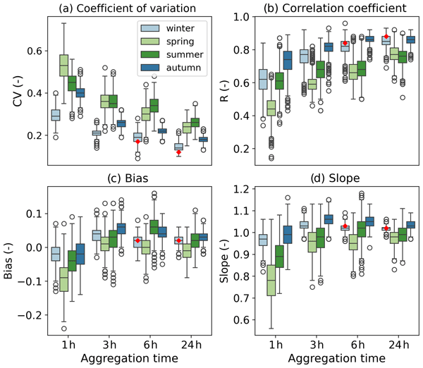
Rain gauge networks from personal weather stations (PWSs) have a network density 100 times higher than dedicated rain gauge networks in the Netherlands. However, PWSs are prone to several sources of error, as they are generally not installed and maintained according to international guidelines. This study systematically quantifies and describes the uncertainties arising from PWS rainfall estimates. In particular, the focus is on the highest rainfall accumulations.
Hatice Türk, Christine Stumpp, Markus Hrachowitz, Karsten Schulz, Peter Strauss, Günter Blöschl, and Michael Stockinger
Hydrol. Earth Syst. Sci., 29, 3935–3956, https://doi.org/10.5194/hess-29-3935-2025, https://doi.org/10.5194/hess-29-3935-2025, 2025
Short summary
Short summary
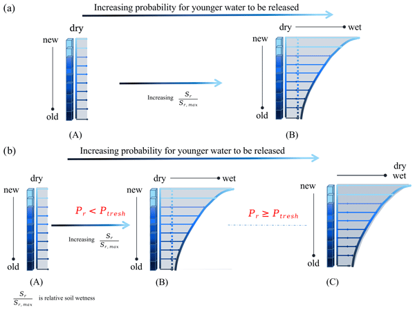
Using advances in transit time estimation and tracer data, we tested if fast-flow transit times are controlled solely by soil moisture or if they are also controlled by precipitation intensity. We used soil-moisture-dependent and precipitation-intensity-conditional transfer functions. We showed that a significant portion of event water bypasses the soil matrix through fast flow paths (overland flow, tile drains, preferential-flow paths) in dry soil conditions for both low- and high-intensity precipitation.
Magali Ponds, Sarah Hanus, Harry Zekollari, Marie-Claire ten Veldhuis, Gerrit Schoups, Roland Kaitna, and Markus Hrachowitz
Hydrol. Earth Syst. Sci., 29, 3545–3568, https://doi.org/10.5194/hess-29-3545-2025, https://doi.org/10.5194/hess-29-3545-2025, 2025
Short summary
Short summary
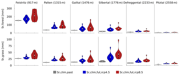
This research examines how future climate changes impact root zone storage, a key hydrological model parameter. Root zone storage – the soil water accessible to plants – adapts to climate but is often kept constant in models. We estimated climate-adapted storage in six Austrian Alps catchments. While storage increased, streamflow projections showed minimal change, which suggests that dynamic root zone representation is less critical in humid regions but warrants further study in arid areas.
Peter Kalverla, Imme Benedict, Chris Weijenborg, and Ruud J. van der Ent
Geosci. Model Dev., 18, 4335–4352, https://doi.org/10.5194/gmd-18-4335-2025, https://doi.org/10.5194/gmd-18-4335-2025, 2025
Short summary
Short summary
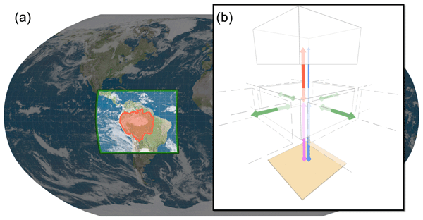
We introduce a new version of WAM2layers (Water Accounting Model – 2 layers), a computer program that tracks how the weather brings water from one place to another. It uses data from weather and climate models, whose resolution is steadily increasing. Processing the latest data had become a challenge, and the updates presented here ensure that WAM2layers runs smoothly again. We also made it easier to use the program and to understand its source code. This makes it more transparent, reliable, and easier to maintain.
Muhammad Ibrahim, Miriam Coenders-Gerrits, Ruud van der Ent, and Markus Hrachowitz
Hydrol. Earth Syst. Sci., 29, 1703–1723, https://doi.org/10.5194/hess-29-1703-2025, https://doi.org/10.5194/hess-29-1703-2025, 2025
Short summary
Short summary
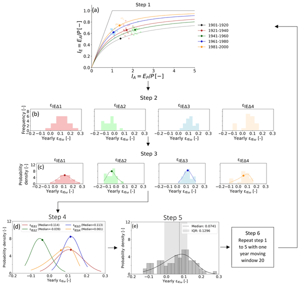
The quantification of precipitation into evaporation and runoff is vital for water resources management. The Budyko framework, based on aridity and evaporative indices of a catchment, can be an ideal tool for that. However, recent research highlights deviations of catchments from the expected evaporative index, casting doubt on its reliability. This study quantifies deviations of 2387 catchments, finding them minor and predictable. Integrating these into predictions upholds the framework's efficacy.
Wouter R. Berghuijs, Ross A. Woods, Bailey J. Anderson, Anna Luisa Hemshorn de Sánchez, and Markus Hrachowitz
Hydrol. Earth Syst. Sci., 29, 1319–1333, https://doi.org/10.5194/hess-29-1319-2025, https://doi.org/10.5194/hess-29-1319-2025, 2025
Short summary
Short summary
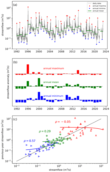
Water balances of catchments will often strongly depend on their state in the recent past, but such memory effects may persist at annual timescales. We use global data sets to show that annual memory is typically absent in precipitation but strong in terrestrial water stores and also present in evaporation and streamflow (including low flows and floods). Our experiments show that hysteretic models provide behaviour that is consistent with these observed memory behaviours.
Jordy Salmon-Monviola, Ophélie Fovet, and Markus Hrachowitz
Hydrol. Earth Syst. Sci., 29, 127–158, https://doi.org/10.5194/hess-29-127-2025, https://doi.org/10.5194/hess-29-127-2025, 2025
Short summary
Short summary
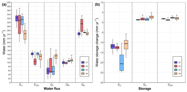
To increase the predictive power of hydrological models, it is necessary to improve their consistency, i.e. their physical realism, which is measured by the ability of the model to reproduce observed system dynamics. Using a model to represent the dynamics of water and nitrate and dissolved organic carbon concentrations in an agricultural catchment, we showed that using solute-concentration data for calibration is useful to improve the hydrological consistency of the model.
Chandrakant Singh, Ruud van der Ent, Ingo Fetzer, and Lan Wang-Erlandsson
Earth Syst. Dynam., 15, 1543–1565, https://doi.org/10.5194/esd-15-1543-2024, https://doi.org/10.5194/esd-15-1543-2024, 2024
Short summary
Short summary
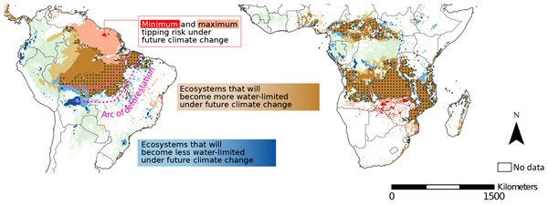
Tropical rainforests risk tipping to savanna under future climate change. By analysing ecosystem root zone dynamics using hydroclimate data from Earth system models, we project the tipping risks for these rainforests. Our findings suggest that although some transition risks may be inevitable, most can still be mitigated by adapting to less severe climate change scenarios. Limiting global surface temperatures to meet the Paris Agreement targets is critical to preserving these ecosystems.
Alberto Bassi, Marvin Höge, Antonietta Mira, Fabrizio Fenicia, and Carlo Albert
Hydrol. Earth Syst. Sci., 28, 4971–4988, https://doi.org/10.5194/hess-28-4971-2024, https://doi.org/10.5194/hess-28-4971-2024, 2024
Short summary
Short summary
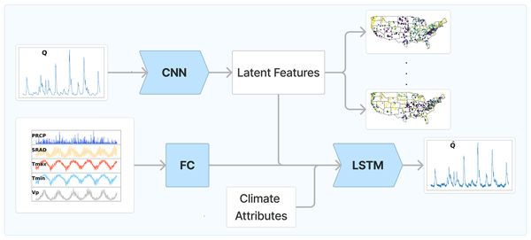
The goal is to remove the impact of meteorological drivers in order to uncover the unique landscape fingerprints of a catchment from streamflow data. Our results reveal an optimal two-feature summary for most catchments, with a third feature associated with aridity and intermittent flow that is needed for challenging cases. Baseflow index, aridity, and soil or vegetation attributes strongly correlate with learnt features, indicating their importance for streamflow prediction.
Nienke Tempel, Laurène Bouaziz, Riccardo Taormina, Ellis van Noppen, Jasper Stam, Eric Sprokkereef, and Markus Hrachowitz
Hydrol. Earth Syst. Sci., 28, 4577–4597, https://doi.org/10.5194/hess-28-4577-2024, https://doi.org/10.5194/hess-28-4577-2024, 2024
Short summary
Short summary
This study explores the impact of climatic variability on root zone water storage capacities and, thus, on hydrological predictions. Analysing data from 286 areas in Europe and the US, we found that, despite some variations in root zone storage capacity due to changing climatic conditions over multiple decades, these changes are generally minor and have a limited effect on water storage and river flow predictions.
Hongkai Gao, Markus Hrachowitz, Lan Wang-Erlandsson, Fabrizio Fenicia, Qiaojuan Xi, Jianyang Xia, Wei Shao, Ge Sun, and Hubert H. G. Savenije
Hydrol. Earth Syst. Sci., 28, 4477–4499, https://doi.org/10.5194/hess-28-4477-2024, https://doi.org/10.5194/hess-28-4477-2024, 2024
Short summary
Short summary
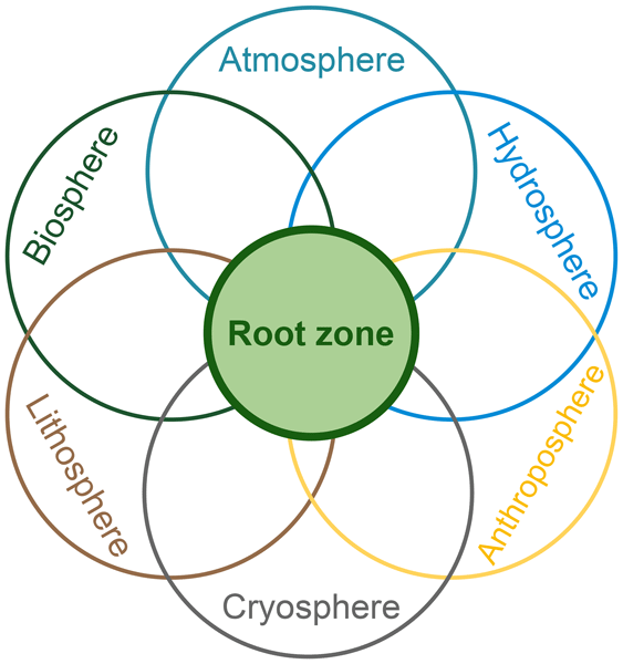
The concept of the root zone is widely used but lacks a precise definition. Its importance in Earth system science is not well elaborated upon. Here, we clarified its definition with several similar terms to bridge the multi-disciplinary gap. We underscore the key role of the root zone in the Earth system, which links the biosphere, hydrosphere, lithosphere, atmosphere, and anthroposphere. To better represent the root zone, we advocate for a paradigm shift towards ecosystem-centred modelling.
Siyuan Wang, Markus Hrachowitz, and Gerrit Schoups
Hydrol. Earth Syst. Sci., 28, 4011–4033, https://doi.org/10.5194/hess-28-4011-2024, https://doi.org/10.5194/hess-28-4011-2024, 2024
Short summary
Short summary
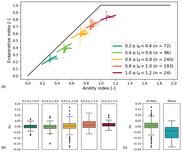
Root zone storage capacity (Sumax) changes significantly over multiple decades, reflecting vegetation adaptation to climatic variability. However, this temporal evolution of Sumax cannot explain long-term fluctuations in the partitioning of water fluxes as expressed by deviations ΔIE from the parametric Budyko curve over time with different climatic conditions, and it does not have any significant effects on shorter-term hydrological response characteristics of the upper Neckar catchment.
Athanasios Tsiokanos, Martine Rutten, Ruud J. van der Ent, and Remko Uijlenhoet
Hydrol. Earth Syst. Sci., 28, 3327–3345, https://doi.org/10.5194/hess-28-3327-2024, https://doi.org/10.5194/hess-28-3327-2024, 2024
Short summary
Short summary
We focus on past high-flow events to find flood drivers in the Geul. We also explore flood drivers’ trends across various timescales and develop a new method to detect the main direction of a trend. Our results show that extreme 24 h precipitation alone is typically insufficient to cause floods. The combination of extreme rainfall and wet initial conditions determines the chance of flooding. Precipitation that leads to floods increases in winter, whereas no consistent trends are found in summer.
Peter Reichert, Kai Ma, Marvin Höge, Fabrizio Fenicia, Marco Baity-Jesi, Dapeng Feng, and Chaopeng Shen
Hydrol. Earth Syst. Sci., 28, 2505–2529, https://doi.org/10.5194/hess-28-2505-2024, https://doi.org/10.5194/hess-28-2505-2024, 2024
Short summary
Short summary
We compared the predicted change in catchment outlet discharge to precipitation and temperature change for conceptual and machine learning hydrological models. We found that machine learning models, despite providing excellent fit and prediction capabilities, can be unreliable regarding the prediction of the effect of temperature change for low-elevation catchments. This indicates the need for caution when applying them for the prediction of the effect of climate change.
Fransje van Oorschot, Ruud J. van der Ent, Andrea Alessandri, and Markus Hrachowitz
Hydrol. Earth Syst. Sci., 28, 2313–2328, https://doi.org/10.5194/hess-28-2313-2024, https://doi.org/10.5194/hess-28-2313-2024, 2024
Short summary
Short summary
Vegetation plays a crucial role in regulating the water cycle by transporting water from the subsurface to the atmosphere via roots; this transport depends on the extent of the root system. In this study, we quantified the effect of irrigation on roots at a global scale. Our results emphasize the importance of accounting for irrigation in estimating the vegetation root extent, which is essential to adequately represent the water cycle in hydrological and climate models.
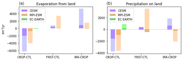
Steven J. De Hertog, Carmen E. Lopez-Fabara, Ruud van der Ent, Jessica Keune, Diego G. Miralles, Raphael Portmann, Sebastian Schemm, Felix Havermann, Suqi Guo, Fei Luo, Iris Manola, Quentin Lejeune, Julia Pongratz, Carl-Friedrich Schleussner, Sonia I. Seneviratne, and Wim Thiery
Earth Syst. Dynam., 15, 265–291, https://doi.org/10.5194/esd-15-265-2024, https://doi.org/10.5194/esd-15-265-2024, 2024
Short summary
Short summary
Changes in land use are crucial to achieve lower global warming. However, despite their importance, the effects of these changes on moisture fluxes are poorly understood. We analyse land cover and management scenarios in three climate models involving cropland expansion, afforestation, and irrigation. Results show largely consistent influences on moisture fluxes, with cropland expansion causing a drying and reduced local moisture recycling, while afforestation and irrigation show the opposite.
Jiaxing Liang, Hongkai Gao, Fabrizio Fenicia, Qiaojuan Xi, Yahui Wang, and Hubert H. G. Savenije
EGUsphere, https://doi.org/10.5194/egusphere-2024-550, https://doi.org/10.5194/egusphere-2024-550, 2024
Preprint archived
Short summary
Short summary
The root zone storage capacity (Sumax) is a key element in hydrology and land-atmospheric interaction. In this study, we utilized a hydrological model and a dynamic parameter identification method, to quantify the temporal trends of Sumax for 497 catchments in the USA. We found that 423 catchments (85 %) showed increasing Sumax, which averagely increased from 178 to 235 mm between 1980 and 2014. The increasing trend was also validated by multi-sources data and independent methods.
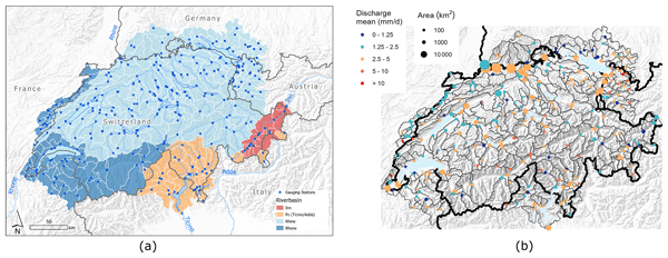
Marvin Höge, Martina Kauzlaric, Rosi Siber, Ursula Schönenberger, Pascal Horton, Jan Schwanbeck, Marius Günter Floriancic, Daniel Viviroli, Sibylle Wilhelm, Anna E. Sikorska-Senoner, Nans Addor, Manuela Brunner, Sandra Pool, Massimiliano Zappa, and Fabrizio Fenicia
Earth Syst. Sci. Data, 15, 5755–5784, https://doi.org/10.5194/essd-15-5755-2023, https://doi.org/10.5194/essd-15-5755-2023, 2023
Short summary
Short summary
CAMELS-CH is an open large-sample hydro-meteorological data set that covers 331 catchments in hydrologic Switzerland from 1 January 1981 to 31 December 2020. It comprises (a) daily data of river discharge and water level as well as meteorologic variables like precipitation and temperature; (b) yearly glacier and land cover data; (c) static attributes of, e.g, topography or human impact; and (d) catchment delineations. CAMELS-CH enables water and climate research and modeling at catchment level.
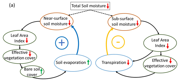
Fransje van Oorschot, Ruud J. van der Ent, Markus Hrachowitz, Emanuele Di Carlo, Franco Catalano, Souhail Boussetta, Gianpaolo Balsamo, and Andrea Alessandri
Earth Syst. Dynam., 14, 1239–1259, https://doi.org/10.5194/esd-14-1239-2023, https://doi.org/10.5194/esd-14-1239-2023, 2023
Short summary
Short summary
Vegetation largely controls land hydrology by transporting water from the subsurface to the atmosphere through roots and is highly variable in space and time. However, current land surface models have limitations in capturing this variability at a global scale, limiting accurate modeling of land hydrology. We found that satellite-based vegetation variability considerably improved modeled land hydrology and therefore has potential to improve climate predictions of, for example, droughts.
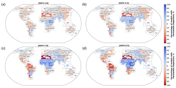
En Ning Lai, Lan Wang-Erlandsson, Vili Virkki, Miina Porkka, and Ruud J. van der Ent
Hydrol. Earth Syst. Sci., 27, 3999–4018, https://doi.org/10.5194/hess-27-3999-2023, https://doi.org/10.5194/hess-27-3999-2023, 2023
Short summary
Short summary
This research scrutinized predicted changes in root zone soil moisture dynamics across different climate scenarios and different climate regions globally between 2021 and 2100. The Mediterranean and most of South America stood out as regions that will likely experience permanently drier conditions, with greater severity observed in the no-climate-policy scenarios. These findings underscore the impact that possible future climates can have on green water resources.
Siyuan Wang, Markus Hrachowitz, Gerrit Schoups, and Christine Stumpp
Hydrol. Earth Syst. Sci., 27, 3083–3114, https://doi.org/10.5194/hess-27-3083-2023, https://doi.org/10.5194/hess-27-3083-2023, 2023
Short summary
Short summary
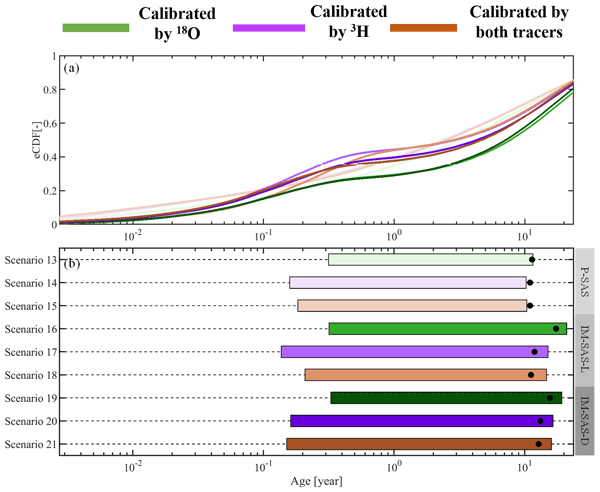
This study shows that previously reported underestimations of water ages are most likely not due to the use of seasonally variable tracers. Rather, these underestimations can be largely attributed to the choices of model approaches which rely on assumptions not frequently met in catchment hydrology. We therefore strongly advocate avoiding the use of this model type in combination with seasonally variable tracers and instead adopting StorAge Selection (SAS)-based or comparable model formulations.
Hongkai Gao, Fabrizio Fenicia, and Hubert H. G. Savenije
Hydrol. Earth Syst. Sci., 27, 2607–2620, https://doi.org/10.5194/hess-27-2607-2023, https://doi.org/10.5194/hess-27-2607-2023, 2023
Short summary
Short summary
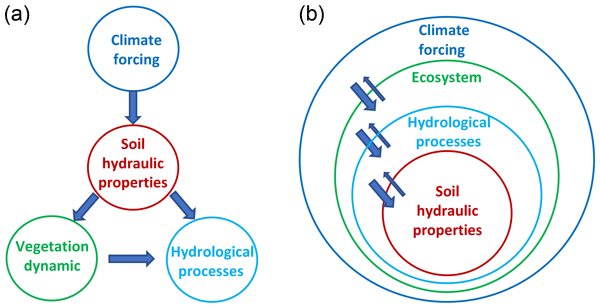
It is a deeply rooted perception that soil is key in hydrology. In this paper, we argue that it is the ecosystem, not the soil, that is in control of hydrology. Firstly, in nature, the dominant flow mechanism is preferential, which is not particularly related to soil properties. Secondly, the ecosystem, not the soil, determines the land–surface water balance and hydrological processes. Moving from a soil- to ecosystem-centred perspective allows more realistic and simpler hydrological models.
Steven J. De Hertog, Carmen E. Lopez-Fabara, Ruud van der Ent, Jessica Keune, Diego G. Miralles, Raphael Portmann, Sebastian Schemm, Felix Havermann, Suqi Guo, Fei Luo, Iris Manola, Quentin Lejeune, Julia Pongratz, Carl-Friedrich Schleussner, Sonia I. Seneviratne, and Wim Thiery
EGUsphere, https://doi.org/10.5194/egusphere-2023-953, https://doi.org/10.5194/egusphere-2023-953, 2023
Preprint archived
Short summary
Short summary
Land cover and management changes can affect the climate and water availability. In this study we use climate model simulations of extreme global land cover changes (afforestation, deforestation) and land management changes (irrigation) to understand the effects on the global water cycle and local to continental water availability. We show that cropland expansion generally leads to higher evaporation and lower amounts of precipitation and afforestation and irrigation expansion to the opposite.

Pau Wiersma, Jerom Aerts, Harry Zekollari, Markus Hrachowitz, Niels Drost, Matthias Huss, Edwin H. Sutanudjaja, and Rolf Hut
Hydrol. Earth Syst. Sci., 26, 5971–5986, https://doi.org/10.5194/hess-26-5971-2022, https://doi.org/10.5194/hess-26-5971-2022, 2022
Short summary
Short summary
We test whether coupling a global glacier model (GloGEM) with a global hydrological model (PCR-GLOBWB 2) leads to a more realistic glacier representation and to improved basin runoff simulations across 25 large-scale basins. The coupling does lead to improved glacier representation, mainly by accounting for glacier flow and net glacier mass loss, and to improved basin runoff simulations, mostly in strongly glacier-influenced basins, which is where the coupling has the most impact.
Judith Uwihirwe, Alessia Riveros, Hellen Wanjala, Jaap Schellekens, Frederiek Sperna Weiland, Markus Hrachowitz, and Thom A. Bogaard
Nat. Hazards Earth Syst. Sci., 22, 3641–3661, https://doi.org/10.5194/nhess-22-3641-2022, https://doi.org/10.5194/nhess-22-3641-2022, 2022
Short summary
Short summary
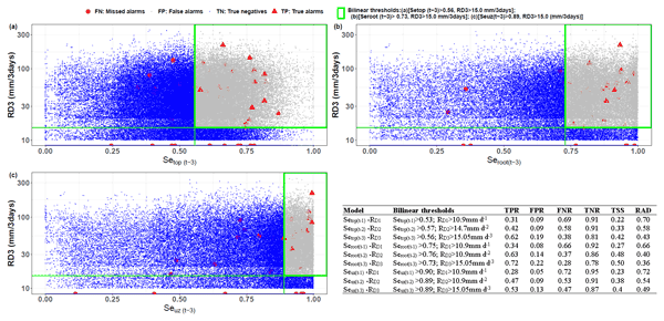
This study compared gauge-based and satellite-based precipitation products. Similarly, satellite- and hydrological model-derived soil moisture was compared to in situ soil moisture and used in landslide hazard assessment and warning. The results reveal the cumulative 3 d rainfall from the NASA-GPM to be the most effective landslide trigger. The modelled antecedent soil moisture in the root zone was the most informative hydrological variable for landslide hazard assessment and warning in Rwanda.
Marvin Höge, Andreas Scheidegger, Marco Baity-Jesi, Carlo Albert, and Fabrizio Fenicia
Hydrol. Earth Syst. Sci., 26, 5085–5102, https://doi.org/10.5194/hess-26-5085-2022, https://doi.org/10.5194/hess-26-5085-2022, 2022
Short summary
Short summary
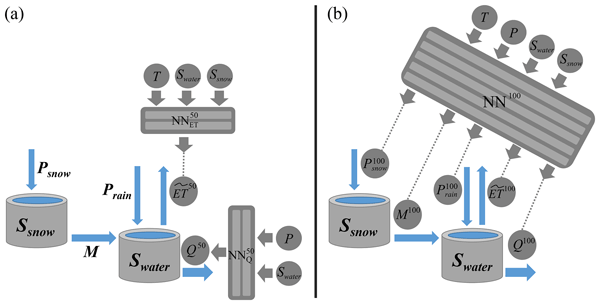
Neural ODEs fuse physics-based models with deep learning: neural networks substitute terms in differential equations that represent the mechanistic structure of the system. The approach combines the flexibility of machine learning with physical constraints for inter- and extrapolation. We demonstrate that neural ODE models achieve state-of-the-art predictive performance while keeping full interpretability of model states and processes in hydrologic modelling over multiple catchments.
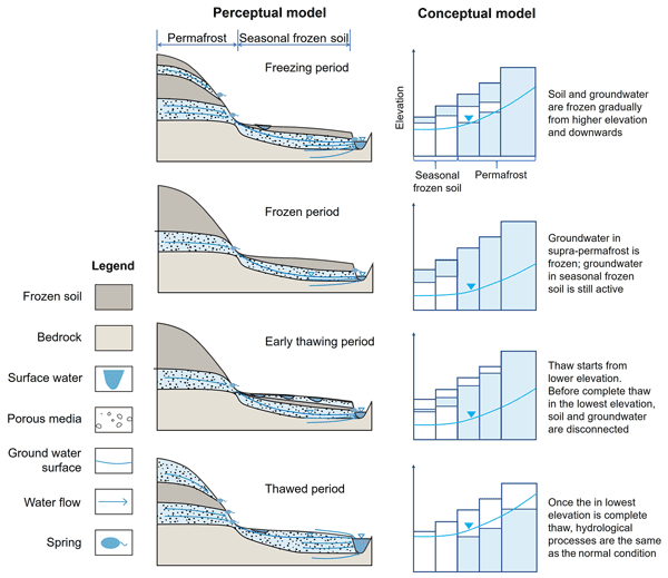
Hongkai Gao, Chuntan Han, Rensheng Chen, Zijing Feng, Kang Wang, Fabrizio Fenicia, and Hubert Savenije
Hydrol. Earth Syst. Sci., 26, 4187–4208, https://doi.org/10.5194/hess-26-4187-2022, https://doi.org/10.5194/hess-26-4187-2022, 2022
Short summary
Short summary
Frozen soil hydrology is one of the 23 unsolved problems in hydrology (UPH). In this study, we developed a novel conceptual frozen soil hydrological model, FLEX-Topo-FS. The model successfully reproduced the soil freeze–thaw process, and its impacts on hydrologic connectivity, runoff generation, and groundwater. We believe this study is a breakthrough for the 23 UPH, giving us new insights on frozen soil hydrology, with broad implications for predicting cold region hydrology in future.
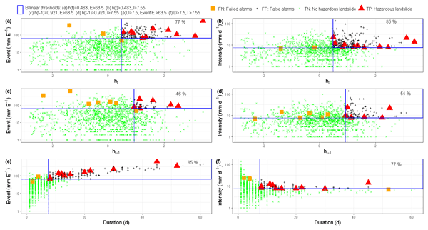
Judith Uwihirwe, Markus Hrachowitz, and Thom Bogaard
Nat. Hazards Earth Syst. Sci., 22, 1723–1742, https://doi.org/10.5194/nhess-22-1723-2022, https://doi.org/10.5194/nhess-22-1723-2022, 2022
Short summary
Short summary
This research tested the value of regional groundwater level information to improve landslide predictions with empirical models based on the concept of threshold levels. In contrast to precipitation-based thresholds, the results indicated that relying on threshold models exclusively defined using hydrological variables such as groundwater levels can lead to improved landslide predictions due to their implicit consideration of long-term antecedent conditions until the day of landslide occurrence.
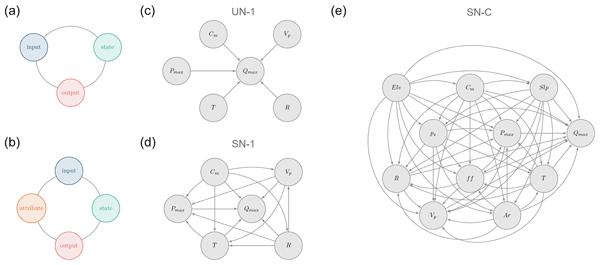
Elisa Ragno, Markus Hrachowitz, and Oswaldo Morales-Nápoles
Hydrol. Earth Syst. Sci., 26, 1695–1711, https://doi.org/10.5194/hess-26-1695-2022, https://doi.org/10.5194/hess-26-1695-2022, 2022
Short summary
Short summary
We explore the ability of non-parametric Bayesian networks to reproduce maximum daily discharge in a given month in a catchment when the remaining hydro-meteorological and catchment attributes are known. We show that a saturated network evaluated in an individual catchment can reproduce statistical characteristics of discharge in about ~ 40 % of the cases, while challenges remain when a saturated network considering all the catchments together is evaluated.
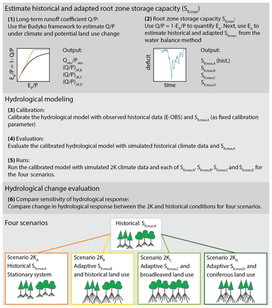
Laurène J. E. Bouaziz, Emma E. Aalbers, Albrecht H. Weerts, Mark Hegnauer, Hendrik Buiteveld, Rita Lammersen, Jasper Stam, Eric Sprokkereef, Hubert H. G. Savenije, and Markus Hrachowitz
Hydrol. Earth Syst. Sci., 26, 1295–1318, https://doi.org/10.5194/hess-26-1295-2022, https://doi.org/10.5194/hess-26-1295-2022, 2022
Short summary
Short summary
Assuming stationarity of hydrological systems is no longer appropriate when considering land use and climate change. We tested the sensitivity of hydrological predictions to changes in model parameters that reflect ecosystem adaptation to climate and potential land use change. We estimated a 34 % increase in the root zone storage parameter under +2 K global warming, resulting in up to 15 % less streamflow in autumn, due to 14 % higher summer evaporation, compared to a stationary system.

Marco Dal Molin, Dmitri Kavetski, and Fabrizio Fenicia
Geosci. Model Dev., 14, 7047–7072, https://doi.org/10.5194/gmd-14-7047-2021, https://doi.org/10.5194/gmd-14-7047-2021, 2021
Short summary
Short summary
This paper introduces SuperflexPy, an open-source Python framework for building flexible conceptual hydrological models. SuperflexPy is available as open-source code and can be used by the hydrological community to investigate improved process representations, for model comparison, and for operational work.
Cited articles
Addor, N., Newman, A. J., Mizukami, N., and Clark, M. P.: The CAMELS data set: catchment attributes and meteorology for large-sample studies, Hydrol. Earth Syst. Sci., 21, 5293–5313, https://doi.org/10.5194/hess-21-5293-2017, 2017. a, b, c
Addor, N., Do, H. X., Alvarez-Garreton, C., Coxon, G., Fowler, K., and Mendoza, P. A.: Large-sample hydrology: recent progress, guidelines for new datasets and grand challenges, Hydrolog. Sci. J., 65, 712–725, https://doi.org/10.1080/02626667.2019.1683182, 2020. a
Araki, R., Holt, A., Hammond, J. C., Husic, A., Coxon, G., and McMillan, H. K.: Continental-scale prediction of hydrologic signatures and processes, Hydrol. Earth Syst. Sci., 30, 3647–3673, https://doi.org/10.5194/hess-30-3647-2026, 2026. a, b, c
Beck, H. E., de Roo, A., and van Dijk, A. I.: Global Maps of Streamflow Characteristics Based on Observations from Several Thousand Catchments, J. Hydrometeorol., 16, 1478–1501, https://doi.org/10.1175/JHM-D-14-0155.1, 2015. a, b
Beck, H. E., Pan, M., Lin, P., Seibert, J., van Dijk, A. I., and Wood, E. F.: Global Fully Distributed Parameter Regionalization Based on Observed Streamflow From 4,229 Headwater Catchments, J. Geophys. Res.-Atmos., 125, e2019JD031485, https://doi.org/10.1029/2019JD031485, 2020. a
Berghuijs, W. R., Hale, K., and Beria, H.: Technical note: Streamflow seasonality using directional statistics, Hydrol. Earth Syst. Sci., 29, 2851–2862, https://doi.org/10.5194/hess-29-2851-2025, 2025. a
Blöschl, G.: Hydrologic synthesis: Across processes, places, and scales, Water Resour. Res., 42, https://doi.org/10.1029/2005WR004319, 2006. a
Blöschl, G., Ardoin-Bardin, S., Bonell, M., Dorninger, M., Goodrich, D., Gutknecht, D., Matamoros, D., Merz, B., Shand, P., and Szolgay, J.: At what scales do climate variability and land cover change impact on flooding and low flows?, Hydrol. Process., 21, 1241–1247, https://doi.org/10.1002/HYP.6669, 2007. a
Blöschl, G., Hall, J., Parajka, J., Perdigão, R. A. P., Merz, B., Arheimer, B., Aronica, G. T., Bilibashi, A., Bonacci, O., Borga, M., Čanjevac, I., Castellarin, A., Chirico, G. B., Claps, P., Fiala, K., Frolova, N., Gorbachova, L., Gül, A., Hannaford, J., Harrigan, S., Kireeva, M., Kiss, A., Kjeldsen, T. R., Kohnová, S., Koskela, J. J., Ledvinka, O., Macdonald, N., Mavrova-Guirguinova, M., Mediero, L., Merz, R., Molnar, P., Montanari, A., Murphy, C., Osuch, M., Ovcharuk, V., Radevski, I., Rogger, M., Salinas, J. L., Sauquet, E., Šraj, M., Szolgay, J., Viglione, A., Volpi, E., Wilson, D., Zaimi, K., and Živković, N.: Changing climate shifts timing of European floods, Science, 357, 588–590, https://doi.org/10.1126/science.aan2506, 2017. a
Blöschl, G., Bierkens, M. F., Chambel, A., Cudennec, C., Destouni, G., Fiori, A., Kirchner, J. W., McDonnell, J. J., Savenije, H. H., Sivapalan, M., Stumpp, C., Toth, E., Volpi, E., Carr, G., Lupton, C., Salinas, J., Széles, B., Viglione, A., Aksoy, H., Allen, S. T., Amin, A., Andréassian, V., Arheimer, B., Aryal, S. K., Baker, V., Bardsley, E., Barendrecht, M. H., Bartosova, A., Batelaan, O., Berghuijs, W. R., Beven, K., Blume, T., Bogaard, T., Borges de Amorim, P., Böttcher, M. E., Boulet, G., Breinl, K., Brilly, M., Brocca, L., Buytaert, W., Castellarin, A., Castelletti, A., Chen, X., Chen, Y., Chen, Y., Chifflard, P., Claps, P., Clark, M. P., Collins, A. L., Croke, B., Dathe, A., David, P. C., de Barros, F. P., de Rooij, G., Di Baldassarre, G., Driscoll, J. M., Duethmann, D., Dwivedi, R., Eris, E., Farmer, W. H., Feiccabrino, J., Ferguson, G., Ferrari, E., Ferraris, S., Fersch, B., Finger, D., Foglia, L., Fowler, K., Gartsman, B., Gascoin, S., Gaume, E., Gelfan, A., Geris, J., Gharari, S., Gleeson, T., Glendell, M., Gonzalez Bevacqua, A., González-Dugo, M. P., Grimaldi, S., Gupta, A. B., Guse, B., Han, D., Hannah, D., Harpold, A., Haun, S., Heal, K., Helfricht, K., Herrnegger, M., Hipsey, M., Hlaváčiková, H., Hohmann, C., Holko, L., Hopkinson, C., Hrachowitz, M., Illangasekare, T. H., Inam, A., Innocente, C., Istanbulluoglu, E., Jarihani, B., Kalantari, Z., Kalvans, A., Khanal, S., Khatami, S., Kiesel, J., Kirkby, M., Knoben, W., Kochanek, K., Kohnová, S., Kolechkina, A., Krause, S., Kreamer, D., Kreibich, H., Kunstmann, H., Lange, H., Liberato, M. L., Lindquist, E., Link, T., Liu, J., Loucks, D. P., Luce, C., Mahé, G., Makarieva, O., Malard, J., Mashtayeva, S., Maskey, S., Mas-Pla, J., Mavrova-Guirguinova, M., Mazzoleni, M., Mernild, S., Misstear, B. D., Montanari, A., Müller-Thomy, H., Nabizadeh, A., Nardi, F., Neale, C., Nesterova, N., Nurtaev, B., Odongo, V. O., Panda, S., Pande, S., Pang, Z., Papacharalampous, G., Perrin, C., Pfister, L., Pimentel, R., Polo, M. J., Post, D., Prieto Sierra, C., Ramos, M. H., Renner, M., Reynolds, J. E., Ridolfi, E., Rigon, R., Riva, M., Robertson, D. E., Rosso, R., Roy, T., Sá, J. H., Salvadori, G., Sandells, M., Schaefli, B., Schumann, A., Scolobig, A., Seibert, J., Servat, E., Shafiei, M., Sharma, A., Sidibe, M., Sidle, R. C., Skaugen, T., Smith, H., Spiessl, S. M., Stein, L., Steinsland, I., Strasser, U., Su, B., Szolgay, J., Tarboton, D., Tauro, F., Thirel, G., Tian, F., Tong, R., Tussupova, K., Tyralis, H., Uijlenhoet, R., van Beek, R., van der Ent, R. J., van der Ploeg, M., Van Loon, A. F., van Meerveld, I., van Nooijen, R., van Oel, P. R., Vidal, J. P., von Freyberg, J., Vorogushyn, S., Wachniew, P., Wade, A. J., Ward, P., Westerberg, I. K., White, C., Wood, E. F., Woods, R., Xu, Z., Yilmaz, K. K., and Zhang, Y.: Twenty-three unsolved problems in hydrology (UPH)–a community perspective, Hydrolog. Sci. J., 64, 1141–1158, https://doi.org/10.1080/02626667.2019.1620507, 2019. a
Brêda, J. P. L., Melsen, L. A., Athanasiadis, I., Van Dijk, A., Siqueira, V. A., Verhoef, A., Zeng, Y., and van der Ploeg, M.: Predictor Importance for Hydrological Fluxes of Global Hydrological and Land Surface Models, Water Resour. Res., 60, e2023WR036418, https://doi.org/10.1029/2023WR036418, 2024. a
Breiman, L.: Random forests, Mach. Learn., 45, 5–32, https://doi.org/10.1023/A:1010933404324, 2001. a
Carrillo, G., Troch, P. A., Sivapalan, M., Wagener, T., Harman, C., and Sawicz, K.: Catchment classification: hydrological analysis of catchment behavior through process-based modeling along a climate gradient, Hydrol. Earth Syst. Sci., 15, 3411–3430, https://doi.org/10.5194/hess-15-3411-2011, 2011. a
Clerc-Schwarzenbach, F. and do Nascimento, T. V. M.: Evaluating E-OBS forcing data for large-sample hydrology using model performance diagnostics, Hydrol. Earth Syst. Sci., 30, 119–140, https://doi.org/10.5194/hess-30-119-2026, 2026. a, b
Coopersmith, E., Yaeger, M. A., Ye, S., Cheng, L., and Sivapalan, M.: Exploring the physical controls of regional patterns of flow duration curves – Part 3: A catchment classification system based on regime curve indicators, Hydrol. Earth Syst. Sci., 16, 4467–4482, https://doi.org/10.5194/hess-16-4467-2012, 2012. a, b
Dal Molin, M., Schirmer, M., Zappa, M., and Fenicia, F.: Understanding dominant controls on streamflow spatial variability to set up a semi-distributed hydrological model: the case study of the Thur catchment, Hydrol. Earth Syst. Sci., 24, 1319–1345, https://doi.org/10.5194/hess-24-1319-2020, 2020. a, b
do Nascimento, T. V. M., Rudlang, J., Höge, M., van der Ent, R., Chappon, M., Seibert, J., Hrachowitz, M., and Fenicia, F.: EStreams: An integrated dataset and catalogue of streamflow, hydro-climatic and landscape variables for Europe, Scientific Data, 11, 879, https://doi.org/10.1038/s41597-024-03706-1, 2024. a, b, c, d, e, f, g, h
do Nascimento, T. V. M., Rudlang, J., Gnann, S., Seibert, J., Hrachowitz, M., and Fenicia, F.: How do geological map details influence the identification of geology-streamflow relationships in large-sample hydrology studies?, Hydrol. Earth Syst. Sci., 29, 7173–7200, https://doi.org/10.5194/hess-29-7173-2025, 2025a. a, b
do Nascimento, T. V. M., Rudlang, J., Höge, M., van der Ent, R., Chappon, M., Seibert, J., Hrachowitz, M., and Fenicia, F.: EStreams: An Integrated Dataset and Catalogue of Streamflow, Hydro-Climatic Variables and Landscape Descriptors for Europe (1.2), Zenodo [data set], https://doi.org/10.5281/zenodo.14778580, 2025b. a
Dooge, J. C.: Looking for hydrologic laws, Water Resour. Res., 22, 46S–58S, https://doi.org/10.1029/WR022I09SP0046S, 1986. a
Fenicia, F. and McDonnell, J. J.: Modeling streamflow variability at the regional scale: (1) perceptual model development through signature analysis, J. Hydrol., 605, 127287, https://doi.org/10.1016/j.jhydrol.2021.127287, 2022. a, b
Fenicia, F., Kavetski, D., Savenije, H. H., Clark, M. P., Schoups, G., Pfister, L., and Freer, J.: Catchment properties, function, and conceptual model representation: Is there a correspondence?, Hydrol. Process., 28, 2451–2467, https://doi.org/10.1002/HYP.9726, 2014. a
Fowler, K. J. A., Acharya, S. C., Addor, N., Chou, C., and Peel, M. C.: CAMELS-AUS: hydrometeorological time series and landscape attributes for 222 catchments in Australia, Earth Syst. Sci. Data, 13, 3847–3867, https://doi.org/10.5194/essd-13-3847-2021, 2021. a
Gudmundsson, L., Do, H. X., Leonard, M., and Westra, S.: The Global Streamflow Indices and Metadata Archive (GSIM) – Part 2: Quality control, time-series indices and homogeneity assessment, Earth Syst. Sci. Data, 10, 787–804, https://doi.org/10.5194/essd-10-787-2018, 2018. a
Gupta, H. V., Perrin, C., Blöschl, G., Montanari, A., Kumar, R., Clark, M., and Andréassian, V.: Large-sample hydrology: a need to balance depth with breadth, Hydrol. Earth Syst. Sci., 18, 463–477, https://doi.org/10.5194/hess-18-463-2014, 2014. a
Hargreaves, G. H. and Samani, Z. A.: Estimating Potential Evapotranspiration, J. Irr. Drain. Div., 108, 225–230, https://doi.org/10.1061/JRCEA4.0001390, 1982. a
He, M., Jiang, S., Ren, L., Cui, H., Qin, T., Du, S., Zhu, Y., Fang, X., and Xu, C. Y.: Streamflow prediction in ungauged catchments through use of catchment classification and deep learning, J. Hydrol., 639, https://doi.org/10.1016/j.jhydrol.2024.131638, 2024. a
Jones Jr., C. E., Leibowitz, S. G., Sawicz, K. A., Comeleo, R. L., Stratton, L. E., Morefield, P. E., and Weaver, C. P.: Using hydrologic landscape classification and climatic time series to assess hydrologic vulnerability of the western U.S. to climate, Hydrol. Earth Syst. Sci., 25, 3179–3206, https://doi.org/10.5194/hess-25-3179-2021, 2021. a
Kemter, M., Marwan, N., Villarini, G., and Merz, B.: Controls on Flood Trends Across the United States, Water Resour. Res., 59, https://doi.org/10.1029/2021WR031673, 2023. a, b
Kerins, D., Knapp, A. S., Liu, F. S., Smykalov, V. D., Berzonsky, M. P., Vierbicher, A., Sadayappan, K., Stewart, B., Andrews, E. M., Sullivan, P. L., Barnard, H. R., Seibert, J., McPhillips, L. E., Singha, K., and Li, L.: Controls From Above and Below: Snow, Soil, and Steepness Drive Diverging Trends of Subsurface Water and Streamflow Dynamics, Hydrol. Process., 39, https://doi.org/10.1002/HYP.70120, 2025. a
Kratzert, F., Nearing, G., Addor, N., Erickson, T., Gauch, M., Gilon, O., Gudmundsson, L., Hassidim, A., Klotz, D., Nevo, S., Shalev, G., and Matias, Y.: Caravan - A global community dataset for large-sample hydrology, Scientific Data, 10, 1–11, https://doi.org/10.1038/s41597-023-01975-w, 2023. a
Laaha, G. and Blöschl, G.: A comparison of low flow regionalisation methods – catchment grouping, J. Hydrol., 323, 193–214, https://doi.org/10.1016/J.JHYDROL.2005.09.001, 2006a. a
Laaha, G. and Blöschl, G.: Seasonality indices for regionalizing low flows, Hydrol. Process., 20, 3851–3878, https://doi.org/10.1002/HYP.6161, 2006b. a
Ladson, A. R., Brown, R., Neal, B., and Nathan, R.: A Standard Approach to Baseflow Separation Using The Lyne and Hollick Filter, Australasian Journal of Water Resources, 17, 25–34, https://doi.org/10.7158/13241583.2013.11465417, 2013. a
McDonnell, J. J. and Woods, R.: On the need for catchment classification, J. Hydrol., 299, 2–3, https://doi.org/10.1016/j.jhydrol.2004.09.003, 2004. a
McDonnell, J. J., Sivapalan, M., Vaché, K., Dunn, S., Grant, G., Haggerty, R., Hinz, C., Hooper, R., Kirchner, J., Roderick, M. L., Selker, J., and Weiler, M.: Moving beyond heterogeneity and process complexity: A new vision for watershed hydrology, Water Resour. Res., 43, https://doi.org/10.1029/2006WR005467, 2007. a
McMillan, H.: Linking hydrologic signatures to hydrologic processes: A review, Hydrol. Process., 34, 1393–1409, https://doi.org/10.1002/HYP.13632, 2020. a
McMillan, H.: A review of hydrologic signatures and their applications, WIREs Water, 8, e1499, https://doi.org/10.1002/wat2.1499, 2021. a
McMillan, H., Westerberg, I., and Branger, F.: Five guidelines for selecting hydrological signatures, Hydrol. Process., 31, 4757–4761, https://doi.org/10.1002/hyp.11300, 2017. a, b, c
McMillan, H., Gnann, S. J., and Araki, R.: Large Scale Evaluation of Relationships Between Hydrologic Signatures and Processes, Water Resour. Res., 58, e2021WR031751, https://doi.org/10.1029/2021WR031751, 2022. a
McMillan, H., Araki, R., Gnann, S., Woods, R., and Wagener, T.: How do hydrologists perceive watersheds? A survey and analysis of perceptual model figures for experimental watersheds, Hydrol. Process., 37, https://doi.org/10.1002/HYP.14845, 2023a. a
McMillan, H., Coxon, G., Araki, R., Salwey, S., Kelleher, C., Zheng, Y., Knoben, W., Gnann, S., Seibert, J., and Bolotin, L.: When good signatures go bad: Applying hydrologic signatures in large sample studies, Hydrol. Process., 37, https://doi.org/10.1002/HYP.14987, 2023b. a
McMillan, H., Araki, R., Bolotin, L., Kim, D. H., Coxon, G., Clark, M., and Seibert, J.: Global patterns in observed hydrologic processes, Nature Water, 3, 497–506, https://doi.org/10.1038/s44221-025-00407-w, 2025. a
Merz, R. and Blöschl, G.: A process typology of regional floods, Water Resour. Res., 39, 1340, https://doi.org/10.1029/2002WR001952, 2003. a
Merz, R. and Blöschl, G.: Regionalisation of catchment model parameters, J. Hydrol., 287, 95–123, https://doi.org/10.1016/J.JHYDROL.2003.09.028, 2004. a
Merz, R. and Blöschl, G.: A regional analysis of event runoff coefficients with respect to climate and catchment characteristics in Austria, Water Resour. Res., 45, https://doi.org/10.1029/2008WR007163, 2009. a
Parajka, J., Merz, R., and Blöschl, G.: A comparison of regionalisation methods for catchment model parameters, Hydrol. Earth Syst. Sci., 9, 157–171, https://doi.org/10.5194/hess-9-157-2005, 2005. a
Parajka, J., Kohnová, S., Bálint, G., Barbuc, M., Borga, M., Claps, P., Cheval, S., Dumitrescu, A., Gaume, E., Hlavčová, K., Merz, R., Pfaundler, M., Stancalie, G., Szolgay, J., and Blöschl, G.: Seasonal characteristics of flood regimes across the Alpine–Carpathian range, J. Hydrol., 394, 78–89, https://doi.org/10.1016/J.JHYDROL.2010.05.015, 2010. a
Rudlang, J. M.: JuliaRudlang/Drivers-of-streamflow-behaviour: Scripts used in analysis of drivers of streamflow behaviour in Europe (Version v2), Zenodo [code], https://doi.org/10.5281/zenodo.17987884, 2025. a
Savenije, H. H. G.: HESS Opinions “Topography driven conceptual modelling (FLEX-Topo)”, Hydrol. Earth Syst. Sci., 14, 2681–2692, https://doi.org/10.5194/hess-14-2681-2010, 2010. a
Sawicz, K., Wagener, T., Sivapalan, M., Troch, P. A., and Carrillo, G.: Catchment classification: empirical analysis of hydrologic similarity based on catchment function in the eastern USA, Hydrol. Earth Syst. Sci., 15, 2895–2911, https://doi.org/10.5194/hess-15-2895-2011, 2011. a, b, c, d
Sivapalan, M.: Prediction in ungauged basins: a grand challenge for theoretical hydrology, Hydrol. Process., 17, 3163–3170, https://doi.org/10.1002/hyp.5155, 2003a. a
Sivapalan, M.: Process complexity at hillslope scale, process simplicity at the watershed scale: is there a connection?, Hydrol. Process., 17, 1037–1041, https://doi.org/10.1002/HYP.5109, 2003b. a
Slater, L., Coxon, G., Brunner, M., McMillan, H., Yu, L., Zheng, Y., Khouakhi, A., Moulds, S., and Berghuijs, W.: Spatial Sensitivity of River Flooding to Changes in Climate and Land Cover Through Explainable AI, Earths Future, 12, https://doi.org/10.1029/2023EF004035, 2024. a
Tarasova, L., Gnann, S., Yang, S., Hartmann, A., and Wagener, T.: Catchment characterization: Current descriptors, knowledge gaps and future opportunities, Earth-Sci. Rev., 252, 104739, https://doi.org/10.1016/j.earscirev.2024.104739, 2024. a, b, c
Troch, P. A., Carrillo, G., Sivapalan, M., Wagener, T., and Sawicz, K.: Climate-vegetation-soil interactions and long-term hydrologic partitioning: signatures of catchment co-evolution, Hydrol. Earth Syst. Sci., 17, 2209–2217, https://doi.org/10.5194/hess-17-2209-2013, 2013. a
Troch, P. A., Lahmers, T., Meira, A., Mukherjee, R., Pedersen, J. W., Roy, T., and Valdés-Pineda, R.: Catchment coevolution: A useful framework for improving predictions of hydrological change?, Water Resour. Res., 51, 4903–4922, https://doi.org/10.1002/2015WR017032, 2015. a
van Oorschot, F., Hrachowitz, M., Viering, T., Alessandri, A., and van der Ent, R. J.: Global patterns in vegetation accessible subsurface water storage emerge from spatially varying importance of individual drivers, Environ. Res. Lett., 19, https://doi.org/10.1088/1748-9326/ad8805, 2024. a
Vu, T., Kiesel, J., Guse, B., Domisch, S., and Fohrer, N.: Disentangling Spatio‐Temporal Impacts of Multiple Environmental Factors on the Global Discharge Regime, Earths Future, 12, https://doi.org/10.1029/2023EF004267, 2024. a
Wagener, T., Sivapalan, M., Troch, P., and Woods, R.: Catchment Classification and Hydrologic Similarity, Geography Compass, 1, 901–931, https://doi.org/10.1111/j.1749-8198.2007.00039.x, 2007. a, b
Yaeger, M., Coopersmith, E., Ye, S., Cheng, L., Viglione, A., and Sivapalan, M.: Exploring the physical controls of regional patterns of flow duration curves – Part 4: A synthesis of empirical analysis, process modeling and catchment classification, Hydrol. Earth Syst. Sci., 16, 4483–4498, https://doi.org/10.5194/hess-16-4483-2012, 2012. a
Ye, S., Yaeger, M., Coopersmith, E., Cheng, L., and Sivapalan, M.: Exploring the physical controls of regional patterns of flow duration curves – Part 2: Role of seasonality, the regime curve, and associated process controls, Hydrol. Earth Syst. Sci., 16, 4447–4465, https://doi.org/10.5194/hess-16-4447-2012, 2012. a
Short summary
River flow (streamflow) behaviour varies across Europe and is shaped by climate and landscape. Using data from more than 7000 European catchments, we identified 10 hydrological response types based on flow magnitude, timing, and seasonality. At the continental scale, streamflow behaviour is mainly driven by climate, but landscape features are equally or more influential in several regions. These results show that streamflow behaviour emerges from the combined effects of climate and landscape.
River flow (streamflow) behaviour varies across Europe and is shaped by climate and landscape....


