
Articles | Volume 30, issue 21
https://doi.org/10.5194/hess-30-6789-2026
© Author(s) 2026. This work is distributed under
the Creative Commons Attribution 4.0 License.
the Creative Commons Attribution 4.0 License.
https://doi.org/10.5194/hess-30-6789-2026
© Author(s) 2026. This work is distributed under
the Creative Commons Attribution 4.0 License.
the Creative Commons Attribution 4.0 License.
Research article
| 
04 Nov 2026
Research article |
| 04 Nov 2026
| 04 Nov 2026
Continental water storage trends and budgets from the GRACE/GRACE-FO Global Gravity-based Groundwater Product (G3P)

International Space Science Institute, Hallerstrasse 6, 3012 Bern, Switzerland
GFZ Helmholtz Centre for Geosciences, Telegrafenberg, 14473 Potsdam, Germany
Junyang Gou
Institute of Geodesy and Photogrammetry, ETH Zurich, Robert-Gnehm-Weg 15, 8093 Zurich, Switzerland
Department of Earth, Atmospheric and Planetary Sciences, Massachusetts Institute of Technology, 77 Massachusetts Avenue, Cambridge, MA 02139, USA
Ulrich Meyer
Astronomical Institute, University of Bern, Sidlerstrasse 5, 3012 Bern, Switzerland
Laura Jensen
GFZ Helmholtz Centre for Geosciences, Telegrafenberg, 14473 Potsdam, Germany
Vincent Humphrey
Federal Office of Meteorology and Climatology MeteoSwiss, Operation Center 1, 8058 Zürich-Flughafen, Switzerland
Wouter Dorigo
Department of Geodesy and Geoinformation, TU Wien, Wiedner Hauptstrasse 8-10, Wien, 1040, Austria
Eva Börgens
GFZ Helmholtz Centre for Geosciences, Telegrafenberg, 14473 Potsdam, Germany
Benedikt Soja
Institute of Geodesy and Photogrammetry, ETH Zurich, Robert-Gnehm-Weg 15, 8093 Zurich, Switzerland
Alexander Gruber
Department of Geodesy and Geoinformation, TU Wien, Wiedner Hauptstrasse 8-10, Wien, 1040, Austria
Annette Eicker
GFZ Helmholtz Centre for Geosciences, Telegrafenberg, 14473 Potsdam, Germany
HafenCity University Hamburg, Henning-Voscherau-Platz 1, Hamburg, 20457, Germany
Michael Rast
International Space Science Institute, Hallerstrasse 6, 3012 Bern, Switzerland
Andreas Güntner
GFZ Helmholtz Centre for Geosciences, Telegrafenberg, 14473 Potsdam, Germany
University of Potsdam, Institute of Environmental Science and Geography, Karl-Liebknecht-Strasse 24-25, Potsdam, 14476, Germany
Related authors
No articles found.
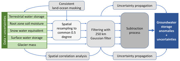
Andreas Güntner, Ehsan Sharifi, Julian Haas, Eva Boergens, Feifei Cao, Christoph Dahle, Neda Darbeheshti, Henryk Dobslaw, Inés Dussaillant, Wouter Dorigo, Frank Flechtner, Adrian Jäggi, Miriam Kosmale, Martin Lasser, Kari Luojus, Ulrich Meyer, Adam Pasik, Wolfgang Preimesberger, Claudia Ruz Vargas, and Michael Zemp
Earth Syst. Sci. Data, 18, 7787–7816, https://doi.org/10.5194/essd-18-7787-2026, https://doi.org/10.5194/essd-18-7787-2026, 2026
Short summary
Short summary
We provide a data set that illustrates how the amount of water that is stored in the subsurface as groundwater varies in time over the continents of the Earth. An important part of the data comes from satellites that track changes in water by its gravity effect. The data allow for assessing how groundwater as the most important freshwater resource for mankind and ecosystems is affected by climate variability, climate change and withdrawal by human activities.
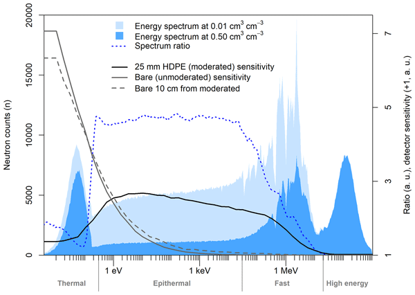
Daniel Rasche, Cosimo Brogi, Markus Köhli, David McJannet, Jannis Weimar, Martin Schrön, Theresa Blume, and Andreas Güntner
Geosci. Instrum. Method. Data Syst., 15, 291–321, https://doi.org/10.5194/gi-15-291-2026, https://doi.org/10.5194/gi-15-291-2026, 2026
Short summary
Short summary
Cosmic-Ray Neutron Sensing is a passive technique to estimate soil moisture, plant traits and snow at the field scale by using instruments sensitive to different neutron energy ranges. For devices sensitive to lower energies, a generalised assessment of the signal response under varying environmental conditions is currently missing. Our simulation-based study highlights the differing signal response of different instruments to environmental variables and provides a baseline for further research.
Ruxandra-Maria Zotta, Moritz Clemens Müller, Raul Lezameta, Sophia Walther, Matthias Forkel, and Wouter Dorigo
EGUsphere, https://doi.org/10.5194/egusphere-2026-6254, https://doi.org/10.5194/egusphere-2026-6254, 2026
This preprint is open for discussion and under review for Biogeosciences (BG).
Short summary
Short summary
We developed a satellite-based method to estimate how much carbon plants take up through photosynthesis worldwide from 2002 to 2020. Using microwave observations, land cover and machine learning, we found that land-cover information improved estimates most, while deeper soil moisture better captured water-related changes in short vegetation. The approach complements existing products, but the total amount of plant carbon uptake remains uncertain.
Junsheng Ding, Wu Chen, Junping Chen, Jungang Wang, Yize Zhang, Duojie Weng, Tong Liu, Xiaolong Mi, Benedikt Soja, and Lei Bai
EGUsphere, https://doi.org/10.22541/essoar.172081357.72805131/v3, https://doi.org/10.22541/essoar.172081357.72805131/v3, 2026
This preprint is open for discussion and under review for Atmospheric Chemistry and Physics (ACP).
Short summary
Short summary
Satellite navigation can help measure water vapor, but most stations lack weather sensors. This limits accurate real-time estimates. We developed a method using artificial intelligence weather models to calculate two key atmospheric quantities locally and quickly anywhere. Tests with three models gave water-vapor errors below one millimeter for five-day forecasts, better than current methods. This can improve real-time weather monitoring and forecasts when more satellite data are used.
Diaa Sheishah, Enas Abdelsamei, Viktoria Blanka-Vegi, Károly Barta, Ahmed M. Ali, Khaldoun Abualhin, Djamil Al-Halbouni, Wouter Dorigo, and Gyorgy Sipos
Earth Syst. Sci. Data Discuss., https://doi.org/10.5194/essd-2026-563, https://doi.org/10.5194/essd-2026-563, 2026
Preprint under review for ESSD
Short summary
Short summary
Soil moisture controls drought, crop water supply, and groundwater recharge, but it is difficult to monitor below the surface. We used national monitoring data from 117 stations and six soil depths to build an open database that links soil moisture, soil type, water retention, and expected electromagnetic responses. The results identify a key mid-depth buffering zone and provide a practical reference for future drought monitoring, irrigation planning, and non-invasive soil-water surveys.
Yitong Yao, Vincent Humphrey, Alexandra G. Konings, Jeffrey D. Wood, Yujie Wang, Ke Liu, Dien Wu, and Christian Frankenberg
EGUsphere, https://doi.org/10.5194/egusphere-2026-4858, https://doi.org/10.5194/egusphere-2026-4858, 2026
This preprint is open for discussion and under review for Geoscientific Model Development (GMD).
Short summary
Short summary
This study presents the first information-content analysis of mono-band and dual-band VOD observations for jointly retrieving vegetation water content, canopy temperature, and vegetation structure using an electromagnetic model, Bayesian inversion, and observing system simulation experiments. Our findings establish a new framework for interpreting VOD dynamics and provide practical guidance for the design of future multi-frequency microwave missions and retrieval algorithms.
Jawairia A. Ahmad, Christopher M. Taylor, Bethan L. Harris, Dávid D. Kovács, Seonaid Anderson, Adrià Amell, Colin Moldenhauer, Steven Wells, and Wouter Dorigo
EGUsphere, https://doi.org/10.5194/egusphere-2026-4687, https://doi.org/10.5194/egusphere-2026-4687, 2026
This preprint is open for discussion and under review for Hydrology and Earth System Sciences (HESS).
Short summary
Short summary
Evaluating the ability of satellite-observed soil moisture products to represent fine-scale land surface information shows that active microwave radar based product from ASCAT captures spatial variability at fine resolution which passive microwave based products miss. Rainfall dataset evaluation using fine-scale soil moisture information highlights the limitations in ERA5 precipitation. Further, fine-scale soil moisture information improves nowcasting of convective storms over dry regions.
Linus Shihora, Laura Jensen, Eva Boergens, Volker Klemann, Robert Dill, Ingo Sasgen, Bert Wouters, Marius Schlaak, Jeanne Sauber-Rosenberg, Shin-Chan Han, Yoshiyuki Tanaka, Carla Braitenberg, Muhammad Tahir Javed, Gerardo Maurizio, Hugo Lecomte, Andrey Babeyko, Niels Hovius, and Henryk Dobslaw
Earth Syst. Sci. Data Discuss., https://doi.org/10.5194/essd-2026-576, https://doi.org/10.5194/essd-2026-576, 2026
Preprint under review for ESSD
Short summary
Short summary
Satellite gravimetry measures Earth's gravity in order to track water, ice, and air redistributions across the Earth. The new ESA Earth System Model 3.0 is a simulated dataset of these mass changes and designed to perform simulation studies of upcoming satellite missions which assess their capabilities to detect various signals. The dataset includes an update of the simulated atmosphere, oceans, hydrology, solid Earth, sea-level changes, earthquakes and selected regional signals.
Julia Pfeffer, Benoît Meyssignac, Rory Bingham, Alejandro Blazquez, Marie Bouih, Carla Braitenberg, Luca Brocca, Henryk Dobslaw, Ramiro Ferrari, Ehsan Forootan, Helena Gerdener, Muhammad Tahir Javed, Laura Jensen, Volker Klemann, Anna Kremer, Jürgen Kusche, Gilles Larnicol, Muhammad Usman Liaqat, Francesco Leopardi, Elisavet-Maria Mamagiannou, Gerardo Maurizio, Roland Pail, Isabelle Panet, Thomas Papanikolaou, Peyman Saemian, Ingo Sasgen, Maike Schumacher, Marius Schlaak, Linus Shihora, Alireza Sobouti, Nico Sneeuw, Mohammad Javad Tourian, Dimitrios Tsoulis, Georgios Vergos, Bert Wouters, Fan Yang, and Ilias Daras
EGUsphere, https://doi.org/10.5194/egusphere-2026-4642, https://doi.org/10.5194/egusphere-2026-4642, 2026
This preprint is open for discussion and under review for Earth Observation (EO).
Short summary
Short summary
The ESA SING project demonstrates how the future satellite gravity missions NGGM and MAGIC will improve observations of continental water storage, oceans, glaciers, sea level, earthquakes, and climate change. Their more accurate, higher-resolution gravity measurements will enhance Earth system monitoring, improve climate and hazard assessments, and strengthen operational services for water management, disaster preparedness, and environmental decision-making.
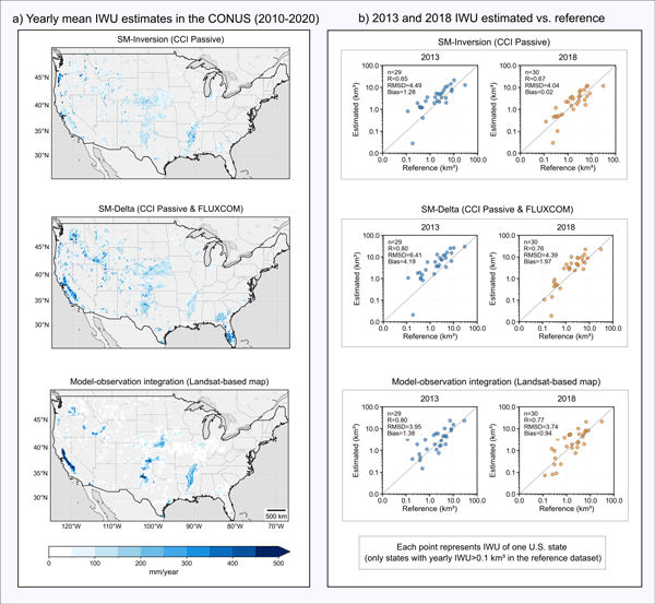
Pierre Laluet, Jacopo Dari, Louise Busschaert, Zdenko Heyvaert, Gabrielle De Lannoy, Pia Langhans, Sara Modanesi, Christian Massari, Luca Brocca, Carla Saltalippi, Renato Morbidelli, Clément Albergel, and Wouter Dorigo
Earth Syst. Sci. Data, 18, 4833–4853, https://doi.org/10.5194/essd-18-4833-2026, https://doi.org/10.5194/essd-18-4833-2026, 2026
Short summary
Short summary
We developed a long-term dataset collection of irrigation water use based on about two decades of satellite observations, three distinct approaches, and many input datasets. The collection provides monthly estimates for major agricultural regions and helps describe how irrigation varies across locations, seasons, and years. It offers a foundation for improving how irrigation is quantified, compared across methods, and integrated into large-scale hydrological and climate studies.
Elena Leonarduzzi, Alexander Gruber, and Reed M. Maxwell
EGUsphere, https://doi.org/10.5194/egusphere-2026-2956, https://doi.org/10.5194/egusphere-2026-2956, 2026
This preprint is open for discussion and under review for Hydrology and Earth System Sciences (HESS).
Short summary
Short summary
Soil moisture is essential for natural hazards prediction, agriculture, and weather and climate forecasting, but current measurements cannot provide the needed detail across large areas. Our approach combines machine learning, physics-based hydrological modeling, and observations to produce high-resolution soil moisture maps, overcoming key limitations of existing approaches. This provides a promising path toward high-resolution soil moisture products, beneficial for many applications.
Rachel Wai-Ying Wu, Dominik Büeler, Maria Pyrina, Jonathan Day, Adel Imamovic, Vincent Humphrey, and Daniela I.V. Domeisen
EGUsphere, https://doi.org/10.5194/egusphere-2026-2465, https://doi.org/10.5194/egusphere-2026-2465, 2026
Short summary
Short summary
Compound heat-drought events threaten health, agriculture, and energy. Using ECMWF sub-seasonal hindcasts, we find that physical coupling increases forecast skill by ~10 % relative to assuming event independence. However, skill drops significantly where land-atmosphere interactions – namely soil moisture feedbacks – are misrepresented. We identify European regions where these forecasts are most reliable and highlight physical biases as the primary barrier to accuracy elsewhere.
Oscar M. Baez-Villanueva, Alfredo Crespo-Otero, Sara Modanesi, Pierre Laluet, Sergio Vicente-Serrano, Jaap Schellekens, Jacopo Dari, Hylke E. Beck, Wouter Dorigo, Christian Massari, Chiara Corbari, Joppe Massant, Kwint Delbare, Olivier Bonte, Aaron Boone, Diego Fernández-Prieto, and Diego G. Miralles
EGUsphere, https://doi.org/10.5194/egusphere-2026-1856, https://doi.org/10.5194/egusphere-2026-1856, 2026
Short summary
Short summary
We developed a new method to estimate daily land evaporation at high resolution across the Iberian Peninsula, explicitly accounting for irrigation. By combining satellite and meteorological data, we show that irrigation can strongly increase evaporation in agricultural areas. The results better match ground observations and improve understanding of water use. This approach can support farming decisions and water management at the regional scale, and will be extended to global applications.
Ehsan Modiri, Oldrich Rakovec, Pallav Kumar Shrestha, Almudena García-García, Leandro Avila, Katie Blackford, Elizabeth Cooper, Bram Droppers, Paolo Filippucci, Milan Fischer, Matěj Orság, Pietro Stradiotti, Luca Brocca, Douglas B. Clark, Wouter Dorigo, Stefan Kollet, Jian Peng, Niko Wanders, and Luis Samaniego
EGUsphere, https://doi.org/10.5194/egusphere-2026-1012, https://doi.org/10.5194/egusphere-2026-1012, 2026
Short summary
Short summary
Drought impacts water supply, agriculture, and ecosystems, yet hydrological models often disagree on when and where drought occurs. This study tested whether satellite observations can improve how models represent soil moisture drought in the Rhine River basin. Using several models and major drought events, we show that satellite data improve spatial realism and reveal important differences among models, helping to better understand uncertainty in drought monitoring and early warning.
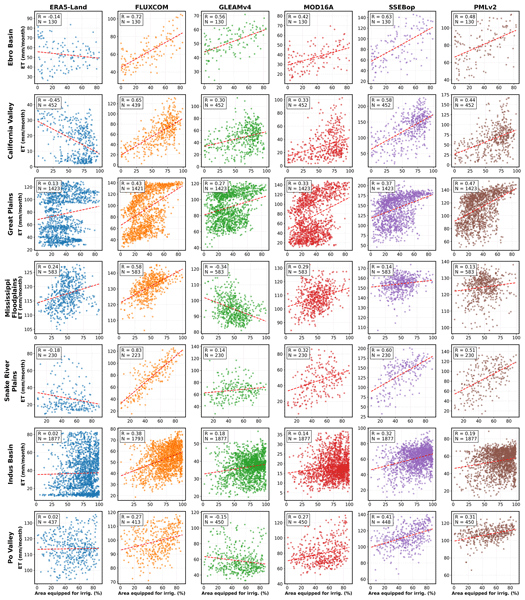
Pierre Laluet, Chiara Corbari, Oscar Baez-Villanueva, Sophia Walther, Yongqiang Zhang, Joaquín Muñoz-Sabater, Clément Albergel, and Wouter Dorigo
Hydrol. Earth Syst. Sci., 30, 1779–1799, https://doi.org/10.5194/hess-30-1779-2026, https://doi.org/10.5194/hess-30-1779-2026, 2026
Short summary
Short summary
We examined how well global datasets estimate evapotranspiration, the water moving from land to the air, in irrigated areas. We compared six widely used products with irrigation maps, satellite estimates, and field measurements across different climate regions. Some datasets better capture irrigation effects, especially those using temperature and vegetation satellite data. This work helps guide dataset selection and supports better inclusion of irrigation in hydrological and climate models.
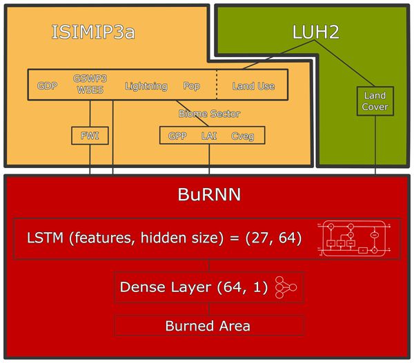
Seppe Lampe, Lukas Gudmundsson, Basil Kraft, Stijn Hantson, Douglas Kelley, Vincent Humphrey, Bertrand Le Saux, Emilio Chuvieco, and Wim Thiery
Geosci. Model Dev., 19, 955–988, https://doi.org/10.5194/gmd-19-955-2026, https://doi.org/10.5194/gmd-19-955-2026, 2026
Short summary
Short summary
We introduce BuRNN (BUrned area modelling by Recurrent Neural Networks), a model which estimates monthly burned area based on satellite observations and climate, vegetation, and socio-economic data using machine learning. BuRNN outperforms existing process-based fire models, which improves our capabilities of modelling past and future burned areas.
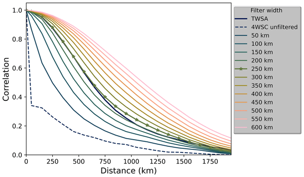
Ehsan Sharifi, Julian Haas, Eva Boergens, Henryk Dobslaw, and Andreas Güntner
Hydrol. Earth Syst. Sci., 29, 6985–6998, https://doi.org/10.5194/hess-29-6985-2025, https://doi.org/10.5194/hess-29-6985-2025, 2025
Short summary
Short summary
This study presents a method to make the spatial resolution of global Water Storage Compartments (WSCs) compatible with terrestrial water storage (TWS) data from Gravity Recovery And Climate Experiment (GRACE) missions. The method compares the spatial structure of the WSCs and TWS by considering the correlation between neighboring grid cells. An isotropic Gaussian filter with an optimal filter width of 250 km is found to be the most suitable, ensuring compatibility for consistent comparison with GRACE data in hydrological applications.
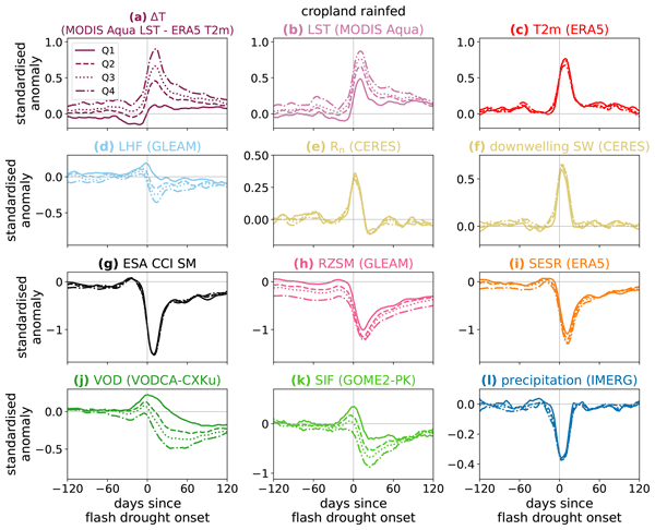
Bethan L. Harris, Christopher M. Taylor, Wouter Dorigo, Ruxandra-Maria Zotta, Darren Ghent, and Iván Noguera
Hydrol. Earth Syst. Sci., 29, 6917–6933, https://doi.org/10.5194/hess-29-6917-2025, https://doi.org/10.5194/hess-29-6917-2025, 2025
Short summary
Short summary
An improved understanding of land-atmosphere coupling processes during flash (rapid-onset) droughts is needed to aid the development of forecasts for these events. We use satellite observations to investigate the surface energy budget during flash droughts globally. The most intense events show a perturbed surface energy budget months before onset. In some regions, vegetation observations 1–2 months before onset provide information on the likelihood of heat extremes during an event.

Endrit Shehaj, Stephen Leroy, Kerri Cahoy, Juliana Chew, and Benedikt Soja
Atmos. Meas. Tech., 18, 6659–6680, https://doi.org/10.5194/amt-18-6659-2025, https://doi.org/10.5194/amt-18-6659-2025, 2025
Short summary
Short summary
We investigate the capability of machine learning models, trained with space and ground Global Navigation Satellite Systems (GNSS) observations, to produce fields of refractivity and water vapor that describe the spatiotemporal morphology of atmospheric rivers (ARs) and quantify moisture associated with them to a degree sufficient for atmospheric studies. The reconstructed fields can be used to monitor ARs. It studies what low-Earth orbit (LEO) radio occultation (RO) constellation is appropriate to quantify the structure, location and timing of ARs.
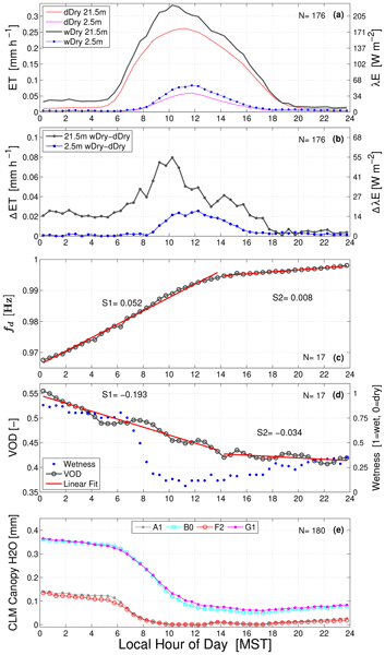
Sean P. Burns, Vincent Humphrey, Ethan D. Gutmann, Mark S. Raleigh, David R. Bowling, and Peter D. Blanken
Biogeosciences, 22, 5741–5769, https://doi.org/10.5194/bg-22-5741-2025, https://doi.org/10.5194/bg-22-5741-2025, 2025
Short summary
Short summary
We compared two techniques that are affected by the amount of liquid water in a forest canopy. One technique relies on remote sensing (a pair of GPSs) and the other uses tree motion generated by the wind. Though completely different, these two techniques show strikingly similar changes when rain falls on an evergreen forest. We combine these measurements with eddy covariance fluxes of water vapor to provide insight into the evaporation of canopy-intercepted precipitation.
Luna Bloin-Wibe, Robin Noyelle, Vincent Humphrey, Urs Beyerle, Reto Knutti, and Erich Fischer
Weather Clim. Dynam., 6, 1147–1177, https://doi.org/10.5194/wcd-6-1147-2025, https://doi.org/10.5194/wcd-6-1147-2025, 2025
Short summary
Short summary
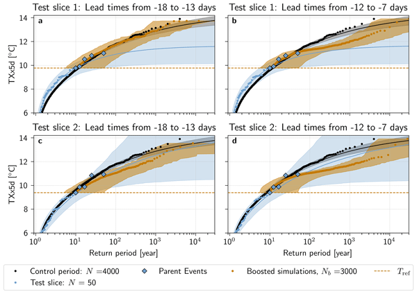
Weather extremes have become more frequent due to climate change. It is therefore crucial to understand them, but since they are rarer than average weather, they are challenging to study. Ensemble Boosting (EB) is a tool that generates extreme climate model events efficiently, but without directly estimating their probability. Here, we present a method to recover these probabilities for a global climate model. EB can thus now be used to find extremes with meaningful statistical information.

Le Liu, Michael Schindelegger, Lara Börger, Judith Foth, and Junyang Gou
Ocean Sci., 21, 2149–2167, https://doi.org/10.5194/os-21-2149-2025, https://doi.org/10.5194/os-21-2149-2025, 2025
Short summary
Short summary
As seawater is moved about by the different types of ocean flow, the pressure at the ocean bottom changes with time and location. We show that such bottom pressure variations are represented reasonably well by high-resolution climate models and that in some regions, like the Arctic Ocean, the intensity of the pressure fluctuations will likely increase under global warming. These insights are useful for the design of future satellite missions that will track mass variations in the Earth system.
Wolfgang Preimesberger, Pietro Stradiotti, and Wouter Dorigo
Earth Syst. Sci. Data, 17, 4305–4329, https://doi.org/10.5194/essd-17-4305-2025, https://doi.org/10.5194/essd-17-4305-2025, 2025
Short summary
Short summary
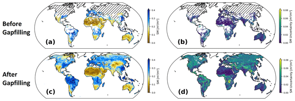
We introduce the official ESA CCI Soil Moisture GAPFILLED climate data record. A univariate interpolation algorithm is applied to predict missing data points without relying on ancillary variables. The dataset includes gap-free uncertainty estimates for all predictions and was validated with independent in situ reference measurements. Our data record is recommended for applications which require global long-term gap-free satellite soil moisture data.
Wolfgang Knorr, Matthew Williams, Tea Thum, Thomas Kaminski, Michael Voßbeck, Marko Scholze, Tristan Quaife, T. Luke Smallman, Susan C. Steele-Dunne, Mariette Vreugdenhil, Tim Green, Sönke Zaehle, Mika Aurela, Alexandre Bouvet, Emanuel Bueechi, Wouter Dorigo, Tarek S. El-Madany, Mirco Migliavacca, Marika Honkanen, Yann H. Kerr, Anna Kontu, Juha Lemmetyinen, Hannakaisa Lindqvist, Arnaud Mialon, Tuuli Miinalainen, Gaétan Pique, Amanda Ojasalo, Shaun Quegan, Peter J. Rayner, Pablo Reyes-Muñoz, Nemesio Rodríguez-Fernández, Mike Schwank, Jochem Verrelst, Songyan Zhu, Dirk Schüttemeyer, and Matthias Drusch
Geosci. Model Dev., 18, 2137–2159, https://doi.org/10.5194/gmd-18-2137-2025, https://doi.org/10.5194/gmd-18-2137-2025, 2025
Short summary
Short summary
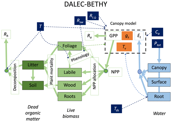
When it comes to climate change, the land surface is where the vast majority of impacts happen. The task of monitoring those impacts across the globe is formidable and must necessarily rely on satellites – at a significant cost: the measurements are only indirect and require comprehensive physical understanding. We have created a comprehensive modelling system that we offer to the research community to explore how satellite data can be better exploited to help us capture the changes that happen on our lands.
Christoph Dahle, Eva Boergens, Ingo Sasgen, Thorben Döhne, Sven Reißland, Henryk Dobslaw, Volker Klemann, Michael Murböck, Rolf König, Robert Dill, Mike Sips, Ulrike Sylla, Andreas Groh, Martin Horwath, and Frank Flechtner
Earth Syst. Sci. Data, 17, 611–631, https://doi.org/10.5194/essd-17-611-2025, https://doi.org/10.5194/essd-17-611-2025, 2025
Short summary
Short summary
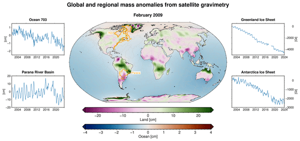
GRACE and GRACE-FO are unique observing systems to quantify mass changes at the Earth’s surface from space. Time series of these mass changes are of high value for various applications, e.g., in hydrology, glaciology, and oceanography. GravIS (Gravity Information Service) provides easy access to user-friendly, regularly updated mass anomaly products. The portal visualizes and describes these data, aiming to highlight their significance for understanding changes in the climate system.
Howlader Mohammad Mehedi Hasan, Petra Döll, Seyed-Mohammad Hosseini-Moghari, Fabrice Papa, and Andreas Güntner
Hydrol. Earth Syst. Sci., 29, 567–596, https://doi.org/10.5194/hess-29-567-2025, https://doi.org/10.5194/hess-29-567-2025, 2025
Short summary
Short summary
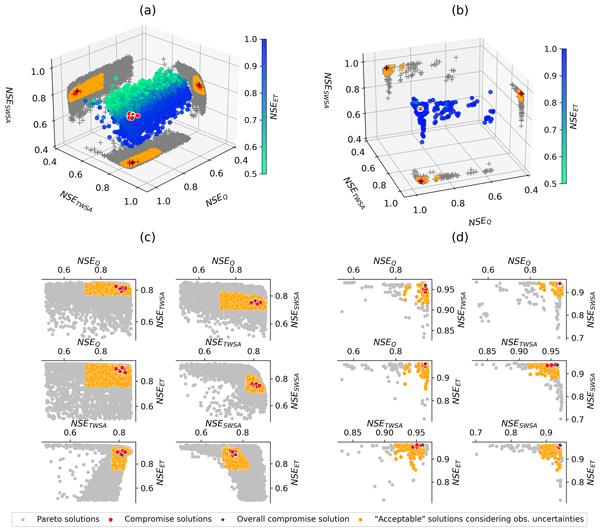
We calibrate a global hydrological model using multiple observations to analyse the benefits and trade-offs of multi-variable calibration. We found such an approach to be very important for understanding the real-world system. However, some observations are very essential to the system, in particular, streamflow. We also showed uncertainties in the calibration results, which are often useful for making informed decisions. We emphasize considering observation uncertainty in model calibration.
Martin Hirschi, Pietro Stradiotti, Bas Crezee, Wouter Dorigo, and Sonia I. Seneviratne
Hydrol. Earth Syst. Sci., 29, 397–425, https://doi.org/10.5194/hess-29-397-2025, https://doi.org/10.5194/hess-29-397-2025, 2025
Short summary
Short summary
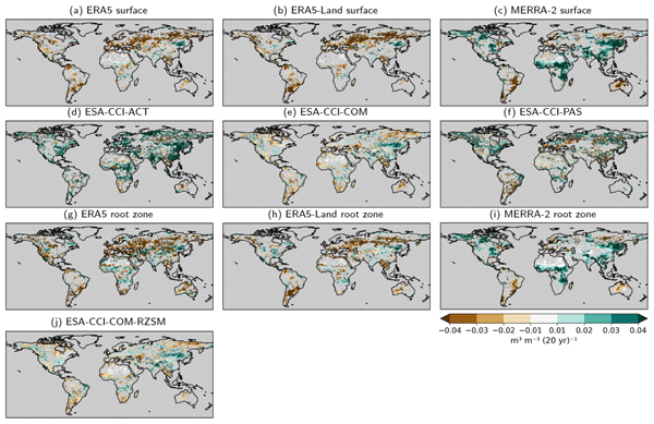
We investigate the potential of long-term satellite and reanalysis products for characterising soil drying by analysing their 2000–2022 soil moisture trends and their representation of agroecological drought events of this period. Soil moisture trends are globally diverse and partly contradictory between products. This also affects the products' drought-detection capacity. Based on the best-estimate products, consistent soil drying is observed over more than 40 % of the land area covered.
Endrit Shehaj, Stephen Leroy, Kerri Cahoy, Alain Geiger, Laura Crocetti, Gregor Moeller, Benedikt Soja, and Markus Rothacher
Atmos. Meas. Tech., 18, 57–72, https://doi.org/10.5194/amt-18-57-2025, https://doi.org/10.5194/amt-18-57-2025, 2025
Short summary
Short summary
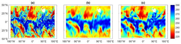
This work investigates whether machine learning (ML) can offer an alternative to existing methods to map radio occultation (RO) products, allowing the extraction of information not visible in direct observations. ML can further improve the results of Bayesian interpolation, a state-of-the-art method to map RO observations. The results display improvements in horizontal and temporal domains, at heights ranging from the planetary boundary layer up to the lower stratosphere, and for all seasons.
Eva Boergens, Andreas Güntner, Mike Sips, Christian Schwatke, and Henryk Dobslaw
Hydrol. Earth Syst. Sci., 28, 4733–4754, https://doi.org/10.5194/hess-28-4733-2024, https://doi.org/10.5194/hess-28-4733-2024, 2024
Short summary
Short summary
The satellites GRACE and GRACE-FO observe continental terrestrial water storage (TWS) changes. With over 20 years of data, we can look into long-term variations in the East Africa Rift region. We focus on analysing the interannual TWS variations compared to meteorological data and observations of the water storage compartments. We found strong influences of natural precipitation variability and human actions over Lake Victoria's water level.

Ruxandra-Maria Zotta, Leander Moesinger, Robin van der Schalie, Mariette Vreugdenhil, Wolfgang Preimesberger, Thomas Frederikse, Richard de Jeu, and Wouter Dorigo
Earth Syst. Sci. Data, 16, 4573–4617, https://doi.org/10.5194/essd-16-4573-2024, https://doi.org/10.5194/essd-16-4573-2024, 2024
Short summary
Short summary
VODCA v2 is a dataset providing vegetation indicators for long-term ecosystem monitoring. VODCA v2 comprises two products: VODCA CXKu, spanning 34 years of observations (1987–2021), suitable for monitoring upper canopy dynamics, and VODCA L (2010–2021), for above-ground biomass monitoring. VODCA v2 has lower noise levels than the previous product version and provides valuable insights into plant water dynamics and biomass changes, even in areas where optical data are limited.
Daniel Rasche, Theresa Blume, and Andreas Güntner
SOIL, 10, 655–677, https://doi.org/10.5194/soil-10-655-2024, https://doi.org/10.5194/soil-10-655-2024, 2024
Short summary
Short summary
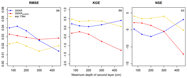
Soil moisture measurements at the field scale are highly beneficial for numerous (soil) hydrological applications. Cosmic-ray neutron sensing (CRNS) allows for the non-invasive monitoring of field-scale soil moisture across several hectares but only for the first few tens of centimetres of the soil. In this study, we modify and test a simple modeling approach to extrapolate CRNS-derived surface soil moisture information down to 450 cm depth and compare calibrated and uncalibrated model results.
Yuanxin Pan, Grzegorz Kłopotek, Laura Crocetti, Rudi Weinacker, Tobias Sturn, Linda See, Galina Dick, Gregor Möller, Markus Rothacher, Ian McCallum, Vicente Navarro, and Benedikt Soja
Atmos. Meas. Tech., 17, 4303–4316, https://doi.org/10.5194/amt-17-4303-2024, https://doi.org/10.5194/amt-17-4303-2024, 2024
Short summary
Short summary
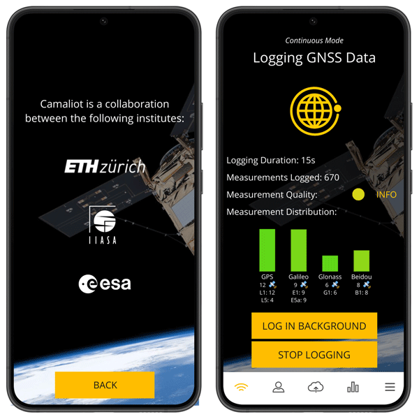
Crowdsourced smartphone GNSS data were processed with a dedicated data processing pipeline and could produce millimeter-level accurate estimates of zenith total delay (ZTD) – a critical atmospheric variable. This breakthrough not only demonstrates the feasibility of using ubiquitous devices for high-precision atmospheric monitoring but also underscores the potential for a global, cost-effective tropospheric monitoring network.
Petra Döll, Howlader Mohammad Mehedi Hasan, Kerstin Schulze, Helena Gerdener, Lara Börger, Somayeh Shadkam, Sebastian Ackermann, Seyed-Mohammad Hosseini-Moghari, Hannes Müller Schmied, Andreas Güntner, and Jürgen Kusche
Hydrol. Earth Syst. Sci., 28, 2259–2295, https://doi.org/10.5194/hess-28-2259-2024, https://doi.org/10.5194/hess-28-2259-2024, 2024
Short summary
Short summary
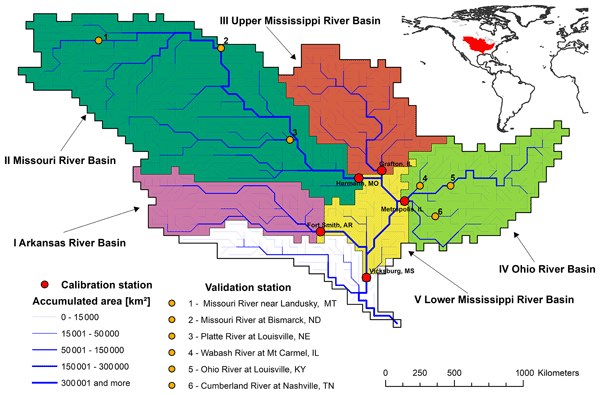
Currently, global hydrological models do not benefit from observations of model output variables to reduce and quantify model output uncertainty. For the Mississippi River basin, we explored three approaches for using both streamflow and total water storage anomaly observations to adjust the parameter sets in a global hydrological model. We developed a method for considering the observation uncertainties to quantify the uncertainty of model output and provide recommendations.

Neda Darbeheshti, Martin Lasser, Ulrich Meyer, Daniel Arnold, and Adrian Jäggi
Earth Syst. Sci. Data, 16, 1589–1599, https://doi.org/10.5194/essd-16-1589-2024, https://doi.org/10.5194/essd-16-1589-2024, 2024
Short summary
Short summary
This paper discusses strategies to improve the GRACE gravity field monthly solutions computed at the Astronomical Institute of the University of Bern. We updated the input observations and background models, as well as improving processing strategies in terms of instrument data screening and instrument parameterization.
Samuel Scherrer, Gabriëlle De Lannoy, Zdenko Heyvaert, Michel Bechtold, Clement Albergel, Tarek S. El-Madany, and Wouter Dorigo
Hydrol. Earth Syst. Sci., 27, 4087–4114, https://doi.org/10.5194/hess-27-4087-2023, https://doi.org/10.5194/hess-27-4087-2023, 2023
Short summary
Short summary
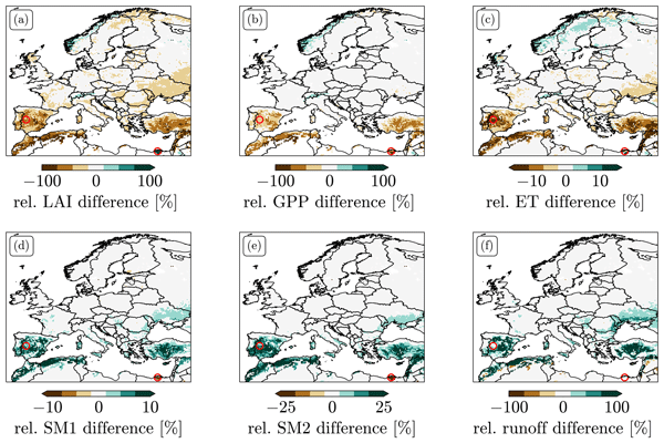
We explored different options for data assimilation (DA) of the remotely sensed leaf area index (LAI). We found strong biases between LAI predicted by Noah-MP and observations. LAI DA that does not take these biases into account can induce unphysical patterns in the resulting LAI and flux estimates and leads to large changes in the climatology of root zone soil moisture. We tested two bias-correction approaches and explored alternative solutions to treating bias in LAI DA.
Adam Pasik, Alexander Gruber, Wolfgang Preimesberger, Domenico De Santis, and Wouter Dorigo
Geosci. Model Dev., 16, 4957–4976, https://doi.org/10.5194/gmd-16-4957-2023, https://doi.org/10.5194/gmd-16-4957-2023, 2023
Short summary
Short summary
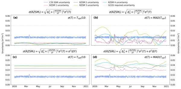
We apply the exponential filter (EF) method to satellite soil moisture retrievals to estimate the water content in the unobserved root zone globally from 2002–2020. Quality assessment against an independent dataset shows satisfactory results. Error characterization is carried out using the standard uncertainty propagation law and empirically estimated values of EF model structural uncertainty and parameter uncertainty. This is followed by analysis of temporal uncertainty variations.
Anna L. Merrifield, Lukas Brunner, Ruth Lorenz, Vincent Humphrey, and Reto Knutti
Geosci. Model Dev., 16, 4715–4747, https://doi.org/10.5194/gmd-16-4715-2023, https://doi.org/10.5194/gmd-16-4715-2023, 2023
Short summary
Short summary
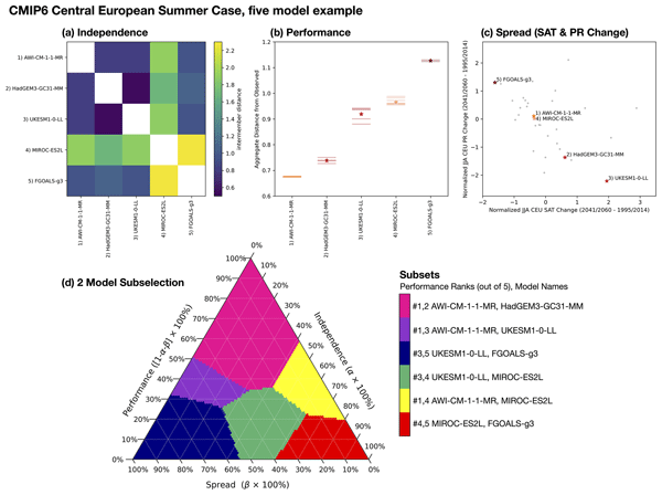
Using all Coupled Model Intercomparison Project (CMIP) models is unfeasible for many applications. We provide a subselection protocol that balances user needs for model independence, performance, and spread capturing CMIP’s projection uncertainty simultaneously. We show how sets of three to five models selected for European applications map to user priorities. An audit of model independence and its influence on equilibrium climate sensitivity uncertainty in CMIP is also presented.
Daniel Rasche, Jannis Weimar, Martin Schrön, Markus Köhli, Markus Morgner, Andreas Güntner, and Theresa Blume
Hydrol. Earth Syst. Sci., 27, 3059–3082, https://doi.org/10.5194/hess-27-3059-2023, https://doi.org/10.5194/hess-27-3059-2023, 2023
Short summary
Short summary
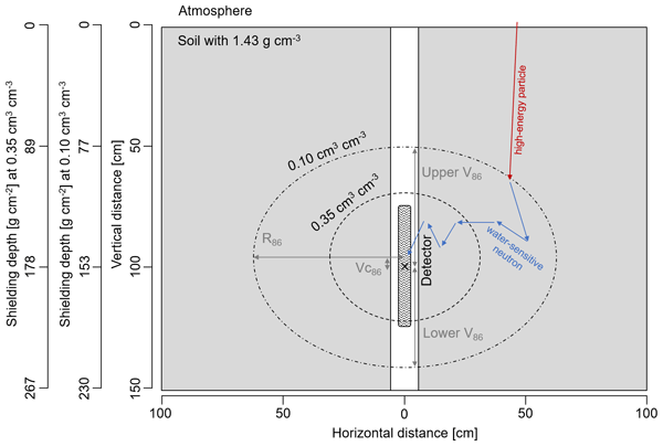
We introduce passive downhole cosmic-ray neutron sensing (d-CRNS) as an approach for the non-invasive estimation of soil moisture in deeper layers of the unsaturated zone which exceed the observational window of above-ground CRNS applications. Neutron transport simulations are used to derive mathematical descriptions and transfer functions, while experimental measurements in an existing groundwater observation well illustrate the feasibility and applicability of the approach.
Maik Heistermann, Till Francke, Lena Scheiffele, Katya Dimitrova Petrova, Christian Budach, Martin Schrön, Benjamin Trost, Daniel Rasche, Andreas Güntner, Veronika Döpper, Michael Förster, Markus Köhli, Lisa Angermann, Nikolaos Antonoglou, Manuela Zude-Sasse, and Sascha E. Oswald
Earth Syst. Sci. Data, 15, 3243–3262, https://doi.org/10.5194/essd-15-3243-2023, https://doi.org/10.5194/essd-15-3243-2023, 2023
Short summary
Short summary
Cosmic-ray neutron sensing (CRNS) allows for the non-invasive estimation of root-zone soil water content (SWC). The signal observed by a single CRNS sensor is influenced by the SWC in a radius of around 150 m (the footprint). Here, we have put together a cluster of eight CRNS sensors with overlapping footprints at an agricultural research site in north-east Germany. That way, we hope to represent spatial SWC heterogeneity instead of retrieving just one average SWC estimate from a single sensor.
Daniel Blank, Annette Eicker, Laura Jensen, and Andreas Güntner
Hydrol. Earth Syst. Sci., 27, 2413–2435, https://doi.org/10.5194/hess-27-2413-2023, https://doi.org/10.5194/hess-27-2413-2023, 2023
Short summary
Short summary
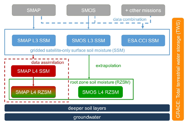
Soil moisture (SM), a key variable of the global water cycle, is analyzed using two types of satellite observations; microwave sensors measure the top few centimeters and satellite gravimetry (GRACE) the full vertical water column. As SM can change very fast, non-standard daily GRACE data are applied for the first time for this analysis. Jointly analyzing these data gives insight into the SM dynamics at different soil depths, and time shifts indicate the infiltration time into deeper layers.
Vincent Humphrey and Christian Frankenberg
Biogeosciences, 20, 1789–1811, https://doi.org/10.5194/bg-20-1789-2023, https://doi.org/10.5194/bg-20-1789-2023, 2023
Short summary
Short summary
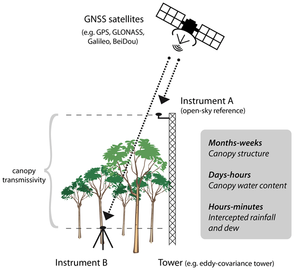
Microwave satellites can be used to monitor how vegetation biomass changes over time or how droughts affect the world's forests. However, such satellite data are still difficult to validate and interpret because of a lack of comparable field observations. Here, we present a remote sensing technique that uses the Global Navigation Satellite System (GNSS) as a makeshift radar, making it possible to observe canopy transmissivity at any existing environmental research site in a cost-efficient way.
Remi Madelon, Nemesio J. Rodríguez-Fernández, Hassan Bazzi, Nicolas Baghdadi, Clement Albergel, Wouter Dorigo, and Mehrez Zribi
Hydrol. Earth Syst. Sci., 27, 1221–1242, https://doi.org/10.5194/hess-27-1221-2023, https://doi.org/10.5194/hess-27-1221-2023, 2023
Short summary
Short summary
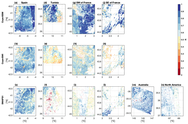
We present an approach to estimate soil moisture (SM) at 1 km resolution using Sentinel-1 and Sentinel-3 satellites. The estimates were compared to other high-resolution (HR) datasets over Europe, northern Africa, Australia, and North America, showing good agreement. However, the discrepancies between the different HR datasets and their lower performances compared with in situ measurements and coarse-resolution datasets show the remaining challenges for large-scale HR SM mapping.
Luisa Schmidt, Matthias Forkel, Ruxandra-Maria Zotta, Samuel Scherrer, Wouter A. Dorigo, Alexander Kuhn-Régnier, Robin van der Schalie, and Marta Yebra
Biogeosciences, 20, 1027–1046, https://doi.org/10.5194/bg-20-1027-2023, https://doi.org/10.5194/bg-20-1027-2023, 2023
Short summary
Short summary
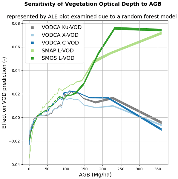
Vegetation attenuates natural microwave emissions from the land surface. The strength of this attenuation is quantified as the vegetation optical depth (VOD) parameter and is influenced by the vegetation mass, structure, water content, and observation wavelength. Here we model the VOD signal as a multi-variate function of several descriptive vegetation variables. The results help in understanding the effects of ecosystem properties on VOD.
Taylor Smith, Ruxandra-Maria Zotta, Chris A. Boulton, Timothy M. Lenton, Wouter Dorigo, and Niklas Boers
Earth Syst. Dynam., 14, 173–183, https://doi.org/10.5194/esd-14-173-2023, https://doi.org/10.5194/esd-14-173-2023, 2023
Short summary
Short summary
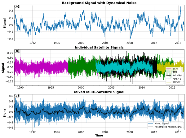
Multi-instrument records with varying signal-to-noise ratios are becoming increasingly common as legacy sensors are upgraded, and data sets are modernized. Induced changes in higher-order statistics such as the autocorrelation and variance are not always well captured by cross-calibration schemes. Here we investigate using synthetic examples how strong resulting biases can be and how they can be avoided in order to make reliable statements about changes in the resilience of a system.
Matthias Forkel, Luisa Schmidt, Ruxandra-Maria Zotta, Wouter Dorigo, and Marta Yebra
Hydrol. Earth Syst. Sci., 27, 39–68, https://doi.org/10.5194/hess-27-39-2023, https://doi.org/10.5194/hess-27-39-2023, 2023
Short summary
Short summary
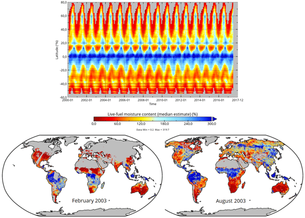
The live fuel moisture content (LFMC) of vegetation canopies is a driver of wildfires. We investigate the relation between LFMC and passive microwave satellite observations of vegetation optical depth (VOD) and develop a method to estimate LFMC from VOD globally. Our global VOD-based estimates of LFMC can be used to investigate drought effects on vegetation and fire risks.

Ryan S. Padrón, Lukas Gudmundsson, Laibao Liu, Vincent Humphrey, and Sonia I. Seneviratne
Biogeosciences, 19, 5435–5448, https://doi.org/10.5194/bg-19-5435-2022, https://doi.org/10.5194/bg-19-5435-2022, 2022
Short summary
Short summary
The answer to how much carbon land ecosystems are projected to remove from the atmosphere until 2100 is different for each Earth system model. We find that differences across models are primarily explained by the annual land carbon sink dependence on temperature and soil moisture, followed by the dependence on CO2 air concentration, and by average climate conditions. Our insights on why each model projects a relatively high or low land carbon sink can help to reduce the underlying uncertainty.
Leander Moesinger, Ruxandra-Maria Zotta, Robin van der Schalie, Tracy Scanlon, Richard de Jeu, and Wouter Dorigo
Biogeosciences, 19, 5107–5123, https://doi.org/10.5194/bg-19-5107-2022, https://doi.org/10.5194/bg-19-5107-2022, 2022
Short summary
Short summary
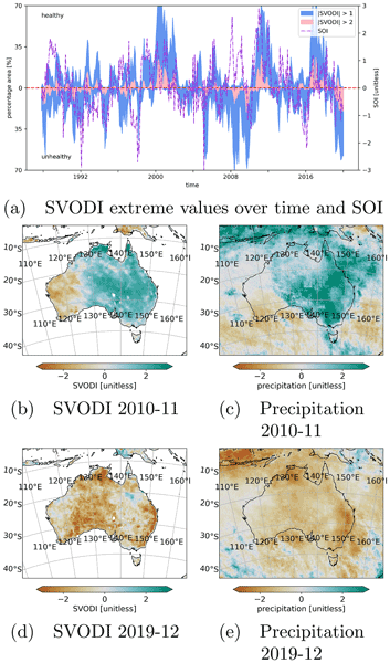
The standardized vegetation optical depth index (SVODI) can be used to monitor the vegetation condition, such as whether the vegetation is unusually dry or wet. SVODI has global coverage, spans the past 3 decades and is derived from multiple spaceborne passive microwave sensors of that period. SVODI is based on a new probabilistic merging method that allows the merging of normally distributed data even if the data are not gap-free.
Matthias Aichinger-Rosenberger, Elmar Brockmann, Laura Crocetti, Benedikt Soja, and Gregor Moeller
Atmos. Meas. Tech., 15, 5821–5839, https://doi.org/10.5194/amt-15-5821-2022, https://doi.org/10.5194/amt-15-5821-2022, 2022
Short summary
Short summary
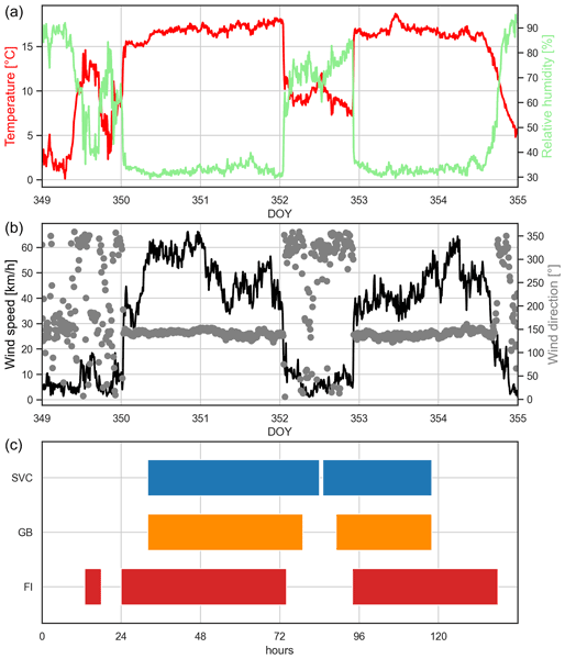
This study develops an innovative approach for the detection and prediction of foehn winds. The approach uses products generated from GNSS (Global Navigation Satellite Systems) in combination with machine learning-based classification algorithms to detect and predict foehn winds at Altdorf, Switzerland. Results are encouraging and comparable to similar studies using meteorological data, which might qualify the method as an additional tool for short-term foehn forecasting in the future.
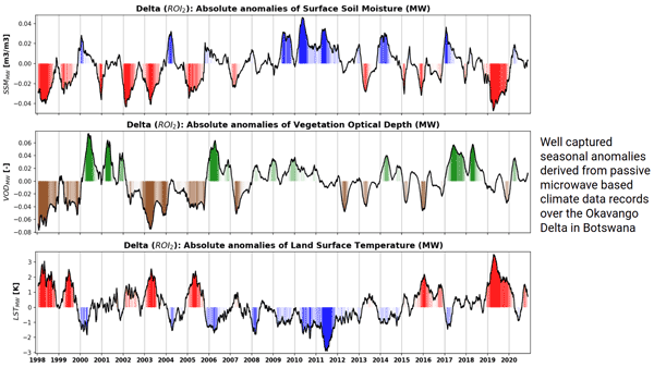
Robin van der Schalie, Mendy van der Vliet, Clément Albergel, Wouter Dorigo, Piotr Wolski, and Richard de Jeu
Hydrol. Earth Syst. Sci., 26, 3611–3627, https://doi.org/10.5194/hess-26-3611-2022, https://doi.org/10.5194/hess-26-3611-2022, 2022
Short summary
Short summary
Climate data records of surface soil moisture, vegetation optical depth, and land surface temperature can be derived from passive microwave observations. The ability of these datasets to properly detect anomalies and extremes is very valuable in climate research and can especially help to improve our insight in complex regions where the current climate reanalysis datasets reach their limitations. Here, we present a case study over the Okavango Delta, where we focus on inter-annual variability.
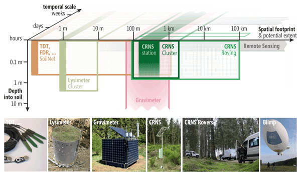
Maik Heistermann, Heye Bogena, Till Francke, Andreas Güntner, Jannis Jakobi, Daniel Rasche, Martin Schrön, Veronika Döpper, Benjamin Fersch, Jannis Groh, Amol Patil, Thomas Pütz, Marvin Reich, Steffen Zacharias, Carmen Zengerle, and Sascha Oswald
Earth Syst. Sci. Data, 14, 2501–2519, https://doi.org/10.5194/essd-14-2501-2022, https://doi.org/10.5194/essd-14-2501-2022, 2022
Short summary
Short summary
This paper presents a dense network of cosmic-ray neutron sensing (CRNS) to measure spatio-temporal soil moisture patterns during a 2-month campaign in the Wüstebach headwater catchment in Germany. Stationary, mobile, and airborne CRNS technology monitored the root-zone water dynamics as well as spatial heterogeneity in the 0.4 km2 area. The 15 CRNS stations were supported by a hydrogravimeter, biomass sampling, and a wireless soil sensor network to facilitate holistic hydrological analysis.
Andreas Wieser, Andreas Güntner, Peter Dietrich, Jan Handwerker, Dina Khordakova, Uta Ködel, Martin Kohler, Hannes Mollenhauer, Bernhard Mühr, Erik Nixdorf, Marvin Reich, Christian Rolf, Martin Schrön, Claudia Schütze, and Ute Weber
Hydrol. Earth Syst. Sci. Discuss., https://doi.org/10.5194/hess-2022-131, https://doi.org/10.5194/hess-2022-131, 2022
Preprint withdrawn
Short summary
Short summary
We present an event-triggered observation concept which covers the entire process chain from heavy precipitation to flooding at the catchment scale. It combines flexible and mobile observing systems out of the fields of meteorology, hydrology and geophysics with stationary networks to capture atmospheric transport processes, heterogeneous precipitation patterns, land surface and subsurface storage processes, and runoff dynamics.
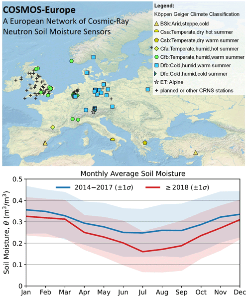
Heye Reemt Bogena, Martin Schrön, Jannis Jakobi, Patrizia Ney, Steffen Zacharias, Mie Andreasen, Roland Baatz, David Boorman, Mustafa Berk Duygu, Miguel Angel Eguibar-Galán, Benjamin Fersch, Till Franke, Josie Geris, María González Sanchis, Yann Kerr, Tobias Korf, Zalalem Mengistu, Arnaud Mialon, Paolo Nasta, Jerzy Nitychoruk, Vassilios Pisinaras, Daniel Rasche, Rafael Rosolem, Hami Said, Paul Schattan, Marek Zreda, Stefan Achleitner, Eduardo Albentosa-Hernández, Zuhal Akyürek, Theresa Blume, Antonio del Campo, Davide Canone, Katya Dimitrova-Petrova, John G. Evans, Stefano Ferraris, Félix Frances, Davide Gisolo, Andreas Güntner, Frank Herrmann, Joost Iwema, Karsten H. Jensen, Harald Kunstmann, Antonio Lidón, Majken Caroline Looms, Sascha Oswald, Andreas Panagopoulos, Amol Patil, Daniel Power, Corinna Rebmann, Nunzio Romano, Lena Scheiffele, Sonia Seneviratne, Georg Weltin, and Harry Vereecken
Earth Syst. Sci. Data, 14, 1125–1151, https://doi.org/10.5194/essd-14-1125-2022, https://doi.org/10.5194/essd-14-1125-2022, 2022
Short summary
Short summary
Monitoring of increasingly frequent droughts is a prerequisite for climate adaptation strategies. This data paper presents long-term soil moisture measurements recorded by 66 cosmic-ray neutron sensors (CRNS) operated by 24 institutions and distributed across major climate zones in Europe. Data processing followed harmonized protocols and state-of-the-art methods to generate consistent and comparable soil moisture products and to facilitate continental-scale analysis of hydrological extremes.
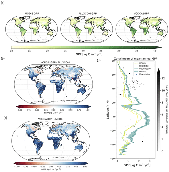
Benjamin Wild, Irene Teubner, Leander Moesinger, Ruxandra-Maria Zotta, Matthias Forkel, Robin van der Schalie, Stephen Sitch, and Wouter Dorigo
Earth Syst. Sci. Data, 14, 1063–1085, https://doi.org/10.5194/essd-14-1063-2022, https://doi.org/10.5194/essd-14-1063-2022, 2022
Short summary
Short summary
Gross primary production (GPP) describes the conversion of CO2 to carbohydrates and can be seen as a filter for our atmosphere of the primary greenhouse gas CO2. We developed VODCA2GPP, a GPP dataset that is based on vegetation optical depth from microwave remote sensing and temperature. Thus, it is mostly independent from existing GPP datasets and also available in regions with frequent cloud coverage. Analysis showed that VODCA2GPP is able to complement existing state-of-the-art GPP datasets.

Tina Trautmann, Sujan Koirala, Nuno Carvalhais, Andreas Güntner, and Martin Jung
Hydrol. Earth Syst. Sci., 26, 1089–1109, https://doi.org/10.5194/hess-26-1089-2022, https://doi.org/10.5194/hess-26-1089-2022, 2022
Short summary
Short summary
We assess the effect of how vegetation is defined in a global hydrological model on the composition of total water storage (TWS). We compare two experiments, one with globally uniform and one with vegetation parameters that vary in space and time. While both experiments are constrained against observational data, we found a drastic change in the partitioning of TWS, highlighting the important role of the interaction between groundwater–soil moisture–vegetation in understanding TWS variations.

Stefan Schlaffer, Marco Chini, Wouter Dorigo, and Simon Plank
Hydrol. Earth Syst. Sci., 26, 841–860, https://doi.org/10.5194/hess-26-841-2022, https://doi.org/10.5194/hess-26-841-2022, 2022
Short summary
Short summary
Prairie wetlands are important for biodiversity and water availability. Knowledge about their variability and spatial distribution is of great use in conservation and water resources management. In this study, we propose a novel approach for the classification of small water bodies from satellite radar images and apply it to our study area over 6 years. The retrieved dynamics show the different responses of small and large wetlands to dry and wet periods.

Daniel Rasche, Markus Köhli, Martin Schrön, Theresa Blume, and Andreas Güntner
Hydrol. Earth Syst. Sci., 25, 6547–6566, https://doi.org/10.5194/hess-25-6547-2021, https://doi.org/10.5194/hess-25-6547-2021, 2021
Short summary
Short summary
Cosmic-ray neutron sensing provides areal average soil moisture measurements. We investigated how distinct differences in spatial soil moisture patterns influence the soil moisture estimates and present two approaches to improve the estimate of soil moisture close to the instrument by reducing the influence of soil moisture further afield. Additionally, we show that the heterogeneity of soil moisture can be assessed based on the relationship of different neutron energies.
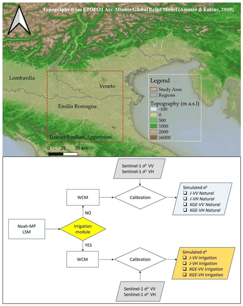
Sara Modanesi, Christian Massari, Alexander Gruber, Hans Lievens, Angelica Tarpanelli, Renato Morbidelli, and Gabrielle J. M. De Lannoy
Hydrol. Earth Syst. Sci., 25, 6283–6307, https://doi.org/10.5194/hess-25-6283-2021, https://doi.org/10.5194/hess-25-6283-2021, 2021
Short summary
Short summary
Worldwide, the amount of water used for agricultural purposes is rising and the quantification of irrigation is becoming a crucial topic. Land surface models are not able to correctly simulate irrigation. Remote sensing observations offer an opportunity to fill this gap as they are directly affected by irrigation. We equipped a land surface model with an observation operator able to transform Sentinel-1 backscatter observations into realistic vegetation and soil states via data assimilation.
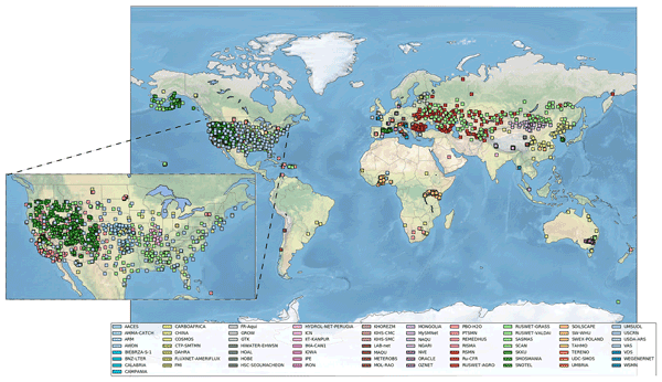
Wouter Dorigo, Irene Himmelbauer, Daniel Aberer, Lukas Schremmer, Ivana Petrakovic, Luca Zappa, Wolfgang Preimesberger, Angelika Xaver, Frank Annor, Jonas Ardö, Dennis Baldocchi, Marco Bitelli, Günter Blöschl, Heye Bogena, Luca Brocca, Jean-Christophe Calvet, J. Julio Camarero, Giorgio Capello, Minha Choi, Michael C. Cosh, Nick van de Giesen, Istvan Hajdu, Jaakko Ikonen, Karsten H. Jensen, Kasturi Devi Kanniah, Ileen de Kat, Gottfried Kirchengast, Pankaj Kumar Rai, Jenni Kyrouac, Kristine Larson, Suxia Liu, Alexander Loew, Mahta Moghaddam, José Martínez Fernández, Cristian Mattar Bader, Renato Morbidelli, Jan P. Musial, Elise Osenga, Michael A. Palecki, Thierry Pellarin, George P. Petropoulos, Isabella Pfeil, Jarrett Powers, Alan Robock, Christoph Rüdiger, Udo Rummel, Michael Strobel, Zhongbo Su, Ryan Sullivan, Torbern Tagesson, Andrej Varlagin, Mariette Vreugdenhil, Jeffrey Walker, Jun Wen, Fred Wenger, Jean Pierre Wigneron, Mel Woods, Kun Yang, Yijian Zeng, Xiang Zhang, Marek Zreda, Stephan Dietrich, Alexander Gruber, Peter van Oevelen, Wolfgang Wagner, Klaus Scipal, Matthias Drusch, and Roberto Sabia
Hydrol. Earth Syst. Sci., 25, 5749–5804, https://doi.org/10.5194/hess-25-5749-2021, https://doi.org/10.5194/hess-25-5749-2021, 2021
Short summary
Short summary
The International Soil Moisture Network (ISMN) is a community-based open-access data portal for soil water measurements taken at the ground and is accessible at https://ismn.earth. Over 1000 scientific publications and thousands of users have made use of the ISMN. The scope of this paper is to inform readers about the data and functionality of the ISMN and to provide a review of the scientific progress facilitated through the ISMN with the scope to shape future research and operations.
Cited articles
Ahmed, M. and Wiese, D. N.: Short-term trends in Africa's freshwater resources: Rates and drivers, Sci. Total Environ., 695, 133843, https://doi.org/10.1016/j.scitotenv.2019.133843, 2019. a
Albergel, C., De Rosnay, P., Gruhier, C., Muñoz-Sabater, J., Hasenauer, S., Isaksen, L., Kerr, Y., and Wagner, W.: Evaluation of remotely sensed and modelled soil moisture products using global ground-based in situ observations, Remote Sens. Environ., 118, 215–226, 2012. a
Allen, M. R. and Tett, S. F.: Checking for model consistency in optimal fingerprinting, Clim. Dynam., 15, 419–434, 1999. a
Amiri-Simkooei, A., Hosseini-Asl, M., Asgari, J., and Zangeneh-Nejad, F.: Offset detection in GPS position time series using multivariate analysis, GPS Solutions, 23, 1–12, 2019. a
Argus, D. F., Martens, H. R., Borsa, A. A., Knappe, E., Wiese, D. N., Alam, S., Anderson, M., Khatiwada, A., Lau, N., Peidou, A., Swarr, M., White, A. M., Bos, M. S., Ellmer, M., Landerer, F. W., and Gardiner, W. P.: Subsurface Water Flux in California's Central Valley and Its Source Watershed From Space Geodesy, Geophys. Res. Lett., 49, e2022GL099583, https://doi.org/10.1029/2022GL099583, 2022. a
Asoka, A., Gleeson, T., Wada, Y., and Mishra, V.: Relative contribution of monsoon precipitation and pumping to changes in groundwater storage in India, Nat. Geosci., 10, 109–117, https://doi.org/10.1038/ngeo2869, 2017. a
Beltaos, S. and Peters, D. L.: Effects of regulation on open-water flows in the lower Peace River, Canada, and implications for the recharge of Peace-Athabasca Delta basins, River Res. Appl., 40, 151–162, 2024. a
Bhanja, S. N., Mukherjee, A., Rodell, M., Wada, Y., Chattopadhyay, S., Velicogna, I., Pangaluru, K., and Famiglietti, J. S.: Groundwater rejuvenation in parts of India influenced by water-policy change implementation, Scientific Reports, 7, 7453, https://doi.org/10.1038/s41598-017-07058-2, 2017. a
Bierkens, M. F. and Wada, Y.: Non-renewable groundwater use and groundwater depletion: a review, Environ. Res. Lett., 14, 063002, https://doi.org/10.1088/1748-9326/ab1a5f, 2019. a
Bindoff, N. L., Stott, P. A., AchutaRao, K. M., Allen, M. R., Gillett, N., Gutzler, D., Hansingo, K., Hegerl, G., Hu, Y., Jain, S., Mokhov, I. I., Overland, J., Perlwitz, J., Sebbari, R., and Zhang, X.: Detection and attribution of climate change: from global to regional, in: Climate Change 2013: The Physical Science Basis. Contribution of Working Group I to the Fifth Assessment Report of the Intergovernmental Panel on Climate Change, edited by Stocker, T. F., Qin, D., Plattner, G.-K., Tignor, M., Allen, S. K., Boschung, J., Nauels, A., Xia, Y., Bex, V., and Midgley, P. M., Cambridge University Press, Cambridge, United Kingdom and New York, NY, USA, 867–952, https://doi.org/10.1017/CBO9781107415324.022, 2013. a
Boergens, E., Güntner, A., Sips, M., Schwatke, C., and Dobslaw, H.: Interannual variations of terrestrial water storage in the East African Rift region, Hydrol. Earth Syst. Sci., 28, 4733–4754, https://doi.org/10.5194/hess-28-4733-2024, 2024. a, b
Bonsal, B. R., Peters, D. L., Seglenieks, F., Rivera, A., and Berg, A.: Changes in freshwater availability across Canada, in: Canada's Changing Climate Report, edited by: Bush, E. and Lemmen, D. S., Government of Canada, Ottawa, Ontario, 261–342, ISBN 978-0-660-30222-5, 2019. a
Braun, M. H., Malz, P., Sommer, C., Farías-Barahona, D., Sauter, T., Casassa, G., Soruco, A., Skvarca, P., and Seehaus, T. C.: Constraining glacier elevation and mass changes in South America, Nat. Clim. Change, 9, 130–136, https://doi.org/10.1038/s41558-018-0375-7, 2019. a, b
Bring, A., Fedorova, I., Dibike, Y., Hinzman, L., Mård, J., Mernild, S. H., Prowse, T., Semenova, O., Stuefer, S. L., and Woo, M.-K.: Arctic terrestrial hydrology: A synthesis of processes, regional effects, and research challenges, J. Geophys. Res.-Biogeo., 121, 621–649, https://doi.org/10.1002/2015JG003131, 2016. a
Bulygina, O. N., Groisman, P. Y., Razuvaev, V. N., and Korshunova, N. N.: Changes in snow cover characteristics over Northern Eurasia since 1966, Environ. Res. Lett., 6, 045204, https://doi.org/10.1088/1748-9326/6/4/045204, 2011. a
Çakan, Ç., Yılmaz, M. T., Dobslaw, H., Ince, E. S., Evrendilek, F., Förste, C., and Yagci, A. L.: Evaluation of globally gridded precipitation data and satellite-based terrestrial water storage products using hydrological drought recovery time, Hydrol. Earth Syst. Sci., 29, 3359–3377, https://doi.org/10.5194/hess-29-3359-2025, 2025. a
Cao, G., Zheng, C., Scanlon, B. R., Liu, J., and Li, W.: Use of flow modeling to assess sustainability of groundwater resources in the North China Plain, Water Resour. Res., 49, 159–175, https://doi.org/10.1029/2012WR011899, 2013. a
Chandanpurkar, H. A., Famiglietti, J. S., Gopalan, K., Wiese, D. N., Wada, Y., Kakinuma, K., Reager, J. T., and Zhang, F.: Unprecedented continental drying, shrinking freshwater availability, and increasing land contributions to sea level rise, Science Advances, 11, eadx0298, https://doi.org/10.1126/sciadv.adx0298, 2025. a, b, c, d, e
Chaudhari, S., Pokhrel, Y., Moran, E., and Miguez-Macho, G.: Multi-decadal hydrologic change and variability in the Amazon River basin: understanding terrestrial water storage variations and drought characteristics, Hydrol. Earth Syst. Sci., 23, 2841–2862, https://doi.org/10.5194/hess-23-2841-2019, 2019. a
Chen, J., Wilson, C., Tapley, B., Longuevergne, L., Yang, Z., and Scanlon, B.: Recent La Plata basin drought conditions observed by satellite gravimetry, J. Geophys. Res.-Atmos., 115, D22108, https://doi.org/10.1029/2010JD014689, 2010. a, b
Chen, J. L., Pekker, T., Wilson, C. R., Tapley, B. D., Kostianoy, A. G., Crétaux, J.-F., and Safarov, E. S.: Long-term Caspian Sea level change, Geophys. Res. Lett., 44, 6993–7001, https://doi.org/10.1002/2017GL073958, 2017. a, b
Choulga, M., Moschini, F., Mazzetti, C., Grimaldi, S., Disperati, J., Beck, H., Salamon, P., and Prudhomme, C.: Technical note: Surface fields for global environmental modelling, Hydrol. Earth Syst. Sci., 28, 2991–3036, https://doi.org/10.5194/hess-28-2991-2024, 2024. a
Ciracì, E., Velicogna, I., and Swenson, S.: Continuity of the mass loss of the world's glaciers and ice caps from the GRACE and GRACE Follow-On missions, Geophys. Res. Lett., 47, e2019GL086926, https://doi.org/10.1029/2019GL086926, 2020. a, b
Cook, B. I., Mankin, J. S., Marvel, K., Williams, A. P., Smerdon, J. E., and Anchukaitis, K. J.: Twenty-First Century Drought Projections in the CMIP6 Forcing Scenarios, Earth's Future, 8, e2019EF001461, https://doi.org/10.1029/2019EF001461, 2020. a
Cui, L., Zhu, C., Wu, Y., Yao, C., Wang, X., An, J., and Wei, P.: Natural-and human-induced influences on terrestrial water storage change in Sichuan, Southwest China from 2003 to 2020, Remote Sensing, 14, 1369, https://doi.org/10.3390/rs14061369, 2022. a, b
Dahle, C., Boergens, E., Sasgen, I., Döhne, T., Reißland, S., Dobslaw, H., Klemann, V., Murböck, M., König, R., Dill, R., Sips, M., Sylla, U., Groh, A., Horwath, M., and Flechtner, F.: GravIS: mass anomaly products from satellite gravimetry, Earth Syst. Sci. Data, 17, 611–631, https://doi.org/10.5194/essd-17-611-2025, 2025. a, b, c
Dangar, S., Asoka, A., and Mishra, V.: Causes and implications of groundwater depletion in India: A review, J. Hydrol., 596, 126103, https://doi.org/10.1016/j.jhydrol.2021.126103, 2021. a
de Graaf, I. E., van Beek, R. L., Gleeson, T., Moosdorf, N., Schmitz, O., Sutanudjaja, E. H., and Bierkens, M. F.: A global-scale two-layer transient groundwater model: Development and application to groundwater depletion, Adv. Water Resour., 102, 53–67, 2017. a
de Melo, D. C. D. and Wendland, E.: Using GRACE to Quantify the Depletion of Terrestrial Water Storage in Northeastern Brazil: The Urucuia Aquifer System, Sci. Total Environ., 705, 135828, https://doi.org/10.1016/j.scitotenv.2019.135828, 2020. a, b
Döll, P., Müller Schmied, H., Schuh, C., Portmann, F. T., and Eicker, A.: Global-scale assessment of groundwater depletion and related groundwater abstractions: Combining hydrological modeling with information from well observations and GRACE satellites, Water Resour. Res., 50, 5698–5720, https://doi.org/10.1002/2014WR015595, 2014. a, b, c, d
Dorigo, W., Dietrich, S., Aires, F., Brocca, L., Carter, S., Cretaux, J.-F., Dunkerley, D., Enomoto, H., Forsberg, R., Güntner, A., Hegglin, M. I., Hollmann, R., Hurst, D. F., Johannessen, J. A., Kummerow, C., Lee, T., Luojus, K., Looser, U., Miralles, D. G., Pellet, V., Recknagel, T., Ruz Vargas, C., Schneider, U., Schoeneich, P., Schröder, M., Tapper, N., Vuglinsky, V., Wagner, W., Yu, L., Zappa, L., Zemp, M., and Aich, V.: Closing the water cycle from observations across scales: Where do we stand?, B. Am. Meteorol. Soc., 102, E1897–E1935, https://doi.org/10.1175/BAMS-D-19-0316.1, 2021. a
Dubois, E., Larocque, M., Gagné, S., and Braun, M.: Climate change impacts on groundwater recharge in cold and humid climates: Controlling processes and thresholds, Climate, 10, 6, https://doi.org/10.3390/cli10010006, 2022. a
Dussaillant, I., Bannwart, J., Paul, F., and Zemp, M.: Glacier mass change global gridded data from 1976 to present derived from the Fluctuations of Glaciers Database, World Glacier Monitoring Service [data set], https://doi.org/10.24381/cds.ba597449, 2023. a
Eicker, A., Schawohl, L., Middendorf, K., Bagge, M., Jensen, L., and Dobslaw, H.: Influence of GIA uncertainty on climate model evaluation with GRACE/GRACE-FO satellite gravimetry data, J. Geophys. Res.-Sol. Ea., 129, e2023JB027769, https://doi.org/10.1029/2023JB027769, 2024. a, b
Famiglietti, J. S., Lo, M., Ho, S. L., Bethune, J., Anderson, K., Syed, T. H., Swenson, S. C., de Linage, C. R., and Rodell, M.: Satellites measure recent rates of groundwater depletion in California's Central Valley, Geophys. Res. Lett., 38, L03403, https://doi.org/10.1029/2010GL046442, 2011. a
Fatolazadeh, F. and Goïta, K.: Mapping terrestrial water storage changes in Canada using GRACE and GRACE-FO, Sci. Total Environ., 779, 146435, https://doi.org/10.1016/j.scitotenv.2021.146435, 2021. a
Favreau, G., Cappelaere, B., Massuel, S., Leblanc, M., Boucher, M., Boulain, N., and Leduc, C.: Land clearing, climate variability, and water resources increase in semiarid southwest Niger: A review, Water Resour. Res., 45, W00A16, https://doi.org/10.1029/2007WR006785, 2009. a
Felfelani, F., Wada, Y., Longuevergne, L., and Pokhrel, Y. N.: Natural and human-induced terrestrial water storage change: A global analysis using hydrological models and GRACE, J. Hydrol., 553, 105–118, 2017. a
Feng, W., Zhong, M., Lemoine, J.-M., Biancale, R., Hsu, H.-T., and Xia, J.: Evaluation of groundwater depletion in North China using the Gravity Recovery and Climate Experiment (GRACE) data and ground-based measurements, Water Resour. Res., 49, 2110–2118, https://doi.org/10.1002/wrcr.20192, 2013. a, b
Franzke, C.: Nonlinear trends, long-range dependence, and climate noise properties of surface temperature, J. Climate, 25, 4172–4183, 2012. a
Frappart, F.: Groundwater storage changes in the major North African transboundary aquifer systems during the GRACE era (2003–2016), Water, 12, 2669, https://doi.org/10.3390/w12102669, 2020. a
Frappart, F. and Ramillien, G.: Monitoring Groundwater Storage Changes Using the Gravity Recovery and Climate Experiment (GRACE) Satellite Mission: A Review, Remote Sensing, 10, 829, https://doi.org/10.3390/rs10060829, 2018. a
Fraser, R. H., Kokelj, S. V., Lantz, T. C., McFarlane-Winchester, M., Olthof, I., and Lacelle, D.: Climate sensitivity of high Arctic permafrost terrain demonstrated by widespread ice-wedge thermokarst on Banks Island, Remote Sensing, 10, 954, https://doi.org/10.3390/rs10060954, 2018. a
Frederikse, T., Landerer, F., Caron, L., Adhikari, S., Parkes, D., Humphrey, V. W., Dangendorf, S., Hogarth, P., Zanna, L., Cheng, L., and Wu, Y.-H.: The causes of sea-level rise since 1900, Nature, 584, 393–397, https://doi.org/10.1038/s41586-020-2591-3, 2020. a
Gafurov, A., Selyuzhenok, V., Latinovic, M., Apel, H., Mamaraimov, A., Salokhiddinov, A., Boergens, E., and Güntner, A.: GRACE observes the natural and irrigation-induced regional redistribution of water storage in Central Asia, Journal of Hydrology: Regional Studies, 56, 101994, https://doi.org/10.1016/j.ejrh.2024.101994, 2024. a
García-Sanz, I., Heine-Fuster, I., Luque, J. A., Pizarro, H., Castillo, R., Pailahual, M., Prieto, M., Pérez-Portilla, P., and Aránguiz-Acuña, A: Limnological Response from High-Altitude Wetlands to the Water Supply in the Andean Altiplano, Scientific Reports, 11, 7681, https://doi.org/10.1038/s41598-021-87162-6, 2021. a
Gardner, A. S., Moholdt, G., Wouters, B., Wolken, G. J., Burgess, D. O., Sharp, M. J., Cogley, J. G., Braun, C., and Labine, C.: Sharply increased mass loss from glaciers and ice caps in the Canadian Arctic Archipelago, Nature, 473, 357–360, https://doi.org/10.1038/nature10089, 2011. a
Gbetkom, P. G., Crétaux, J.-F., Biancamaria, S., Blazquez, A., Paris, A., Tchilibou, M., Gal, L., Kitambo, B., Oliveira, R. A. J., and Gosset, M.: Lake Tanganyika basin water storage variations from 2003–2021 for water balance and flood monitoring, Remote Sensing Applications: Society and Environment, 34, 101182, https://doi.org/10.1016/j.rsase.2024.101182, 2024. a
Gobron, K., Rebischung, P., de Viron, O., Demoulin, A., and Van Camp, M.: Impact of offsets on assessing the low-frequency stochastic properties of geodetic time series, J. Geodesy, 96, 46, https://doi.org/10.1007/s00190-022-01634-9, 2022. a
Gobron, K., Hohensinn, R., Loizeau, X., Bulgin, C. E., Merchant, C. J., Woolliams, E. R., Cox, M. G., Dorigo, W., Howard, T., Langsdale, M., Povey, A. C., Ablain, M., Bogusz, J., Gruber, A., Klos, A., and Mittaz, J.: A Unified Framework for Trend Uncertainty Assessment in Climate Data Records: Demonstration on Global Mean Sea Level, Surv. Geophys., online first, https://doi.org/10.1007/s10712-025-09922-7, 2026. a
Goncalves, J., Petersen, J., Deschamps, P., Hamelin, B., and Baba-Sy, O.: Quantifying the modern recharge of the “fossil” Sahara aquifers, Geophys. Res. Lett., 40, 2673–2678, 2013. a
Gonzales, L., López, V., Huamán, D., Villalobos, C., Espinoza, R., Vega, M., and Ramos, J.: Two Decades of Groundwater Variability in Peru Using Satellite Gravimetry Data, Appl. Sci., 15, 8071, https://doi.org/10.3390/app15148071, 2025. a
Gronewold, A. D. and Rood, R. B.: Recent water level changes across Earth's largest lake system and implications for future variability, J. Great Lakes Res., 45, 1–3, https://doi.org/10.1016/j.jglr.2018.10.012, 2019. a
Gunes, O. and Aydin, C.: Colored noise in GRACE total water storage time series: Its impact on trend significance in the Türkiye region and major world river basins, Adv. Space Res., 74, 1633–1647, https://doi.org/10.1016/j.asr.2024.05.051, 2024. a
Güntner, A., Sharifi, E., Haas, J., Boergens, E., Cao, F., Dahle, C., Darbeheshti, N., Dobslaw, H., Dussaillant, I., Dorigo, W., Flechtner, F., Jäggi, A., Kosmale, M., Lasser, M., Luojus, K., Meyer, U., Pasik, A., Preimersberger, W., Ruz Vargas, C., and Zemp, M.: The Global Gravity-based Groundwater Product (G3P), Earth Syst. Sci. Data Discuss. [preprint], https://doi.org/10.5194/essd-2025-797, in review, 2026. a, b
Güntner, A., Sharifi, E., Haas, J., Boergens, E., Dahle, C., Dobslaw, H., Dorigo, W., Dussailant, I., Flechtner, F., Jäggi, A., Kosmale, M., Luojus, K., Mayer-Gürr, T., Meyer, U., Preimesberger, W., Ruz Vargas, C., and Zemp, M.: Global Gravity-based Groundwater Product (G3P) V.1.12, GFZ Data Services [data set], https://doi.org/10.5880/g3p.2024.001, 2024. a, b, c
Haacker, E. M., Kendall, A. D., and Hyndman, D. W.: Water level declines in the High Plains Aquifer: Predevelopment to resource senescence, Groundwater, 54, 231–242, https://doi.org/10.1111/gwat.12350, 2016. a
Hamdi, M. and Goïta, K.: Analysis of groundwater depletion in the saskatchewan river basin in Canada from coupled SWAT-MODFLOW and satellite gravimetry, Hydrology, 10, 188, https://doi.org/10.3390/hydrology10090188, 2023. a
Hasselmann, K.: Multi-pattern fingerprint method for detection and attribution of climate change, Clim. Dynam., 13, 601–611, 1997. a
Hirschi, M., Stradiotti, P., Crezee, B., Dorigo, W., and Seneviratne, S. I.: Potential of long-term satellite observations and reanalysis products for characterising soil drying: trends and drought events, Hydrol. Earth Syst. Sci., 29, 397–425, https://doi.org/10.5194/hess-29-397-2025, 2025. a, b, c
Hoell, A., Gaughan, A. E., Shukla, S., and Magadzire, T.: The hydrologic effects of synchronous El Niño–Southern oscillation and subtropical Indian ocean dipole events over Southern Africa, J. Hydrometeorol., 18, 2407–2424, 2017. a
Hohensinn, R.: Parameter estimates for GRACE/GRACE-FO TWS and GWS trend analysis (G3P, 2002–2023), Version v1, Zenodo [data set], https://doi.org/10.5281/zenodo.18538047, 2026. a
Hohensinn, R., Ruttner, P., and Bock, Y.: Sensitivity of GNSS to vertical land motion over Europe: effects of geophysical loadings and common-mode errors, J. Geodesy, 98, 68, https://doi.org/10.1007/s00190-024-01856-z, 2024. a
Huang, J., Halpenny, J., Van Der Wal, W., Klatt, C., James, T., and Rivera, A.: Detectability of groundwater storage change within the Great Lakes Water Basin using GRACE, J. Geophys. Res.-Sol. Ea., 117, B08401, https://doi.org/10.1029/2011JB008876, 2012. a
Huang, Q., Wang, P., Wang, R., Yu, J., Frolova, N. L., and Pozdniakov, S. P.: Differential decline in terrestrial water storage across major permafrost-dominated Arctic River basins during the rapid warming period from 1981 to 2020, J. Geophys. Res.-Atmos., 130, e2024JD042978, https://doi.org/10.1029/2024JD042978, 2025. a
Humphrey, V. and Gudmundsson, L.: GRACE-REC: a reconstruction of climate-driven water storage changes over the last century, Earth Syst. Sci. Data, 11, 1153–1170, https://doi.org/10.5194/essd-11-1153-2019, 2019. a
Humphrey, V., Gudmundsson, L., and Seneviratne, S. I.: Assessing global water storage variability from GRACE: Trends, seasonal cycle, subseasonal anomalies and extremes, Surv. Geophys., 37, 357–395, https://doi.org/10.1007/s10712-016-9367-1, 2016. a
Humphrey, V., Gudmundsson, L., and Seneviratne, S. I.: A globalreconstruction of climate-driven subdecadal water storage variability, Geophys. Res. Lett., 44, 2300–2309, https://doi.org/10.1002/2017GL072564, 2017. a, b
Jackson, C. R., Bloomfield, J. P., and Mackay, J. D.: Evidence for changes in historic and future groundwater levels in the UK, Prog. Phys. Geog., 39, 49–67, 2015. a
Jäggi, A., Meyer, U., Lasser, M., Jenny, B., Lopez, T., Flechtner, F., Dahle, C., Förste, C., Mayer-Gürr, T., Kvas, A., Lemoine, J.-M., Bourgogne, S., Weigelt, M., and Groh, A.: International Combination Service for Time-Variable Gravity Fields (COST-G) – Start of Operational Phase and Future Perspectives, International Association of Geodesy Symposia, 152, 57–65, https://doi.org/10.1007/1345_2020_109, 2020. a
Jarugula, S. and McPhaden, M. J.: Indian Ocean Dipole affects eastern tropical Atlantic salinity through Congo River Basin hydrology, Communications Earth & Environment, 4, 366, https://doi.org/10.1038/s43247-023-01027-6, 2023. a
Jensen, L., Eicker, A., Dobslaw, H., Stacke, T., and Humphrey, V.: Long-term wetting and drying trends in land water storage derived from GRACE and CMIP5 models, J. Geophys. Res.-Atmos., 124, 9808–9823, 2019. a
Jiang, Y., Zhou, L., Roundy, P. E., Hua, W., and Raghavendra, A.: Increasing influence of Indian Ocean dipole on precipitation over central equatorial Africa, Geophys. Res. Lett., 48, e2020GL092370, https://doi.org/10.1029/2020GL092370, 2021. a
Kayastha, M. B., Ye, X., Huang, C., and Xue, P.: Future rise of the Great Lakes water levels under climate change, J. Hydrol., 612, 128205, https://doi.org/10.1016/j.jhydrol.2022.128205, 2022. a
Kirshen, A. B., Moran, B. J., Munk, L. A., Russo, A. A., McKnight, S. V., Jenckes, J., Corkran, D. B., Bresee, M., and Boutt, D. F.: Freshwater inflows to closed basins of the Andean plateau in Chile, Argentina, and Bolivia, Communications Earth & Environment, 6, 177, https://doi.org/10.1038/s43247-025-02130-6, 2025. a
Knief, U. and Forstmeier, W.: Violating the normality assumption may be the lesser of two evils, Behav. Res. Methods, 53, 2576–2590, 2021. a
Konikow, L. F.: Long-term groundwater depletion in the United States, Groundwater, 53, 2–9, https://doi.org/10.1111/gwat.12306, 2015. a
Koscielny-Bunde, E., Kantelhardt, J. W., Braun, P., Bunde, A., and Havlin, S.: Long-term persistence and multifractality of river runoff records: Detrended fluctuation studies, J. Hydrol., 322, 120–137, https://doi.org/10.1016/j.jhydrol.2005.03.004, 2006. a
Koutsoyiannis, D.: Climate change, the Hurst phenomenon, and hydrological statistics, Hydrolog. Sci. J., 48, 3–24, 2003. a
Kvas, A., Boergens, E., Dobslaw, H., Eicker, A., Mayer-Guerr, T., and Güntner, A.: Evaluating long-term water storage trends in small catchments and aquifers from a joint inversion of 20 years of GRACE/GRACE-FO mission data, Geophys. J. Int., 236, 1002–1012, 2024. a
Lai, E. N., Wang-Erlandsson, L., Virkki, V., Porkka, M., and van der Ent, R. J.: Root zone soil moisture in over 25 % of global land permanently beyond pre-industrial variability as early as 2050 without climate policy, Hydrol. Earth Syst. Sci., 27, 3999–4018, https://doi.org/10.5194/hess-27-3999-2023, 2023. a
Landerer, F. W., Flechtner, F. M., Save, H., Webb, F. H., Bandikova, T., Bertiger, W. I., Bettadpur, S. V., Byun, S. H., Dahle, C., Dobslaw, H., Fahnestock, E., Harvey, N., Kang, Z., Kruizinga, G. L. H., Loomis, B. D., McCullough, C., Murböck, M., Nagel, P., Paik, M., Pie, N., Poole, S., Strekalov, D., Tamisiea, M. E., Wang, F., Watkins, M. M., Wen, H.-Y., Wiese, D. N., and Yuan, D.-N.: Extending the global mass change data record: GRACE Follow-On instrument and science data performance, Geophys. Res. Lett., 47, e2020GL088306, https://doi.org/10.1029/2020GL088306, 2020. a
Lewkowicz, A. G. and Way, R. G.: Extremes of summer climate trigger thousands of thermokarst landslides in a High Arctic environment, Nat. Commun., 10, 1329, https://doi.org/10.1038/s41467-019-09314-7, 2019. a
Li, B. and Rodell, M.: Terrestrial water storage in 2023, Nature Reviews Earth & Environment, 5, 247–249, 2024. a
Li, J., Wang, S., and Zhou, F.: Time series analysis of long-term terrestrial water storage over Canada from GRACE satellites using principal component analysis, Can. J. Remote Sens., 42, 161–170, https://doi.org/10.1080/07038992.2016.1166042, 2016. a
Li, Z. and Zhang, Y.-K.: Quantifying fractal dynamics of groundwater systems with detrended fluctuation analysis, J. Hydrol., 336, 139–146, 2007. a
Lin, H., Cheng, X., Zheng, L., Peng, X., Feng, W., and Peng, F.: Recent changes in groundwater and surface water in large pan-arctic river basins, Remote Sensing, 14, 607, https://doi.org/10.3390/rs14030607, 2022. a, b
Little, M. A. and Bloomfield, J. P.: Robust evidence for random fractal scaling of groundwater levels in unconfined aquifers, J. Hydrol., 393, 362–369, 2010. a
Lucas, M. C., Kublik, N., Rodrigues, D. B. B., Meira Neto, A. A., Almagro, A., de Melo, D. C. D., Zipper, S. C., and de Oliveira, P. T. S.: Significant Baseflow Reduction in the São Francisco River Basin, Water, 13, https://doi.org/10.3390/w13010002, 2021. a, b
Luojus, K., Pulliainen, J., Takala, M., Lemmetyinen, J., Mortimer, C., Derksen, C., Mudryk, L., Moisander, M., Hiltunen, M., Smolander, T., Ikonen, J., Cohen, J., Salminen, M., Norberg, J., Veijola, K., and Venäläinen, P.: GlobSnow v3.0 Northern Hemisphere snow water equivalent dataset, Scientific Data, 8, https://doi.org/10.1038/s41597-021-00939-2, 2021. a
MacQueen, J.: Some methods for classification and analysis of multivariate observations, in: Proceedings of the Fifth Berkeley Symposium on Mathematical Statistics and Probability, Volume 1: Statistics, University of California Press, 5, 281–298, 1967. a
Mandelbrot, B. B. and Wallis, J. R.: Some long-run properties of geophysical records, Water Resour. Res., 5, 321–340, 1969. a
Merchant, C. J., Paul, F., Popp, T., Ablain, M., Bontemps, S., Defourny, P., Hollmann, R., Lavergne, T., Laeng, A., de Leeuw, G., Mittaz, J., Poulsen, C., Povey, A. C., Reuter, M., Sathyendranath, S., Sandven, S., Sofieva, V. F., and Wagner, W.: Uncertainty information in climate data records from Earth observation, Earth Syst. Sci. Data, 9, 511–527, https://doi.org/10.5194/essd-9-511-2017, 2017. a
Merchant, C. J., Woolliams, E. R., Dorigo, W., Bulgin, C. E., Gobron, K., Hohensinn, R., Loizeau, X., and Tynan, C. P. J.: Stability specifications for climate data records: their meaning and application in evaluating geophysical trend uncertainty, Surv. Geophys., https://doi.org/10.1007/s10712-026-09941-y, 2026. a
Meyer, U., Lasser, M., Dahle, C., Förste, C., Behzadpour, S., Koch, I., and Jäggi, A.: Combined monthly GRACE-FO gravity fields for a Global Gravity-based Groundwater Product, Geophys. J. Int., 236, 456–469, https://doi.org/10.1093/gji/ggad437, 2024. a
Montillet, J.-P. and Bos, M. S.: Geodetic time series analysis in earth sciences, Springer, https://doi.org/10.1007/978-3-030-21718-1, 2019. a
Mudelsee, M.: Climate Time Series Analysis: Classical Statistical and Bootstrap Methods, Springer, Dordrecht, Netherlands, https://doi.org/10.1007/978-90-481-9482-7, ISBN 978-90-481-9482-7, 2010. a
Mudelsee, M.: Trend analysis of climate time series: A review of methods, Earth-Sci. Rev., 190, 310–322, https://doi.org/10.1016/j.earscirev.2018.12.005, 2019. a, b
Muskett, R. R. and Romanovsky, V. E.: Alaskan permafrost groundwater storage changes derived from GRACE and ground measurements, Remote Sensing, 3, 378–397, https://doi.org/10.3390/rs3020378, 2011. a
Naumann, G., Podesta, G., Marengo, J., Luterbacher, J., Bavera, D., Acosta Navarro, J., Arias-Muñoz, C., Barbosa, P., Cammalleri, C., Cuartas Luz, A., De Estrada, M., De Felice, M., De Jager, A., Escobar, C., Fioravanti, G., Giordano, L., Hrast Essenfelder, A., Hidalgo, C., Leal De Moraes, O. L., Maetens, W., Magni, D., Masante, D., Mazzeschi, M., Osman, M., Rossi, L., Seluchi, M., De Los Milagros Skansi, M., Spennemann, P., Spinoni, J., Toreti, A., and Vera, C.: Extreme and Long-Term Drought in the La Plata Basin: Event Evolution and Impact Assessment until September 2022, Technical Report JRC132245, Joint Research Centre (JRC), European Commission, Luxembourg, https://doi.org/10.2760/62557, 2023. a, b
Ni, S., Chen, J., Wilson, C. R., Li, J., Hu, X., and Fu, R.: Global terrestrial water storage changes and connections to ENSO events, Surv. Geophys., 39, 1–22, 2018. a
Nikraftar, Z., Parizi, E., Saber, M., Hosseini, S. M., Ataie-Ashtiani, B., and Simmons, C. T.: Groundwater sustainability assessment in the Middle East using GRACE/GRACE-FO data, Hydrogeol. J., 32, 321–337, 2024. a
Noël, B., van de Berg, W. J., Machguth, H., Lhermitte, S., Howat, I., Fettweis, X., and van den Broeke, M. R.: Six Decades of Glacial Mass Loss in the Canadian Arctic Archipelago, J. Geophys. Res.-Earth, 123, 1430–1449, https://doi.org/10.1029/2017JF004304, 2018. a
Orth, R. and Seneviratne, S. I.: Analysis of soil moisture memory from observations in Europe, J. Geophys. Res.-Atmos., 117, D15115, https://doi.org/10.1029/2011JD017366, 2012. a
Orth, R., Staudinger, M., and Seneviratne, S. I.: Inferring Soil Moisture Memory from Streamflow Observations Using a Simple Water Balance Model, J. Hydrometeorol., 14, 1773–1790, https://doi.org/10.1175/JHM-D-12-099.1, 2013. a
Otosaka, I. N., Shepherd, A., Ivins, E. R., Schlegel, N.-J., Amory, C., van den Broeke, M. R., Horwath, M., Joughin, I., King, M. D., Krinner, G., Nowicki, S., Payne, A. J., Rignot, E., Scambos, T., Simon, K. M., Smith, B. E., Sørensen, L. S., Velicogna, I., Whitehouse, P. L., A, G., Agosta, C., Ahlstrøm, A. P., Blazquez, A., Colgan, W., Engdahl, M. E., Fettweis, X., Forsberg, R., Gallée, H., Gardner, A., Gilbert, L., Gourmelen, N., Groh, A., Gunter, B. C., Harig, C., Helm, V., Khan, S. A., Kittel, C., Konrad, H., Langen, P. L., Lecavalier, B. S., Liang, C.-C., Loomis, B. D., McMillan, M., Melini, D., Mernild, S. H., Mottram, R., Mouginot, J., Nilsson, J., Noël, B., Pattle, M. E., Peltier, W. R., Pie, N., Roca, M., Sasgen, I., Save, H. V., Seo, K.-W., Scheuchl, B., Schrama, E. J. O., Schröder, L., Simonsen, S. B., Slater, T., Spada, G., Sutterley, T. C., Vishwakarma, B. D., van Wessem, J. M., Wiese, D., van der Wal, W., and Wouters, B.: Mass balance of the Greenland and Antarctic ice sheets from 1992 to 2020, Earth Syst. Sci. Data, 15, 1597–1616, https://doi.org/10.5194/essd-15-1597-2023, 2023. a
Pasik, A., Gruber, A., Preimesberger, W., De Santis, D., and Dorigo, W.: Uncertainty estimation for a new exponential-filter-based long-term root-zone soil moisture dataset from Copernicus Climate Change Service (C3S) surface observations, Geosci. Model Dev., 16, 4957–4976, https://doi.org/10.5194/gmd-16-4957-2023, 2023. a
Patterson, H. D. and Thompson, R.: Recovery of inter-block information when block sizes are unequal, Biometrika, 58, 545–554, 1971. a
Pfeffer, J., Cazenave, A., and Barnoud, A.: Analysis of the interannual variability in satellite gravity solutions: detection of climate modes fingerprints in water mass displacements across continents and oceans, Clim. Dynam., 58, 1065–1084, 2022. a
Pokhrel, Y., Felfelani, F., Satoh, Y., Boulange, J., Burek, P., Gädeke, A., Gerten, D., Gosling, S. N., Grillakis, M., Gudmundsson, L., Hanasaki, N., Kim, H., Koutroulis, A., Liu, J., Papadimitriou, L., Schewe, J., Müller Schmied, H., Stacke, T., Telteu, C.-E., Thiery, W., Veldkamp, T., Zhao, F., and Wada, Y.: Global terrestrial water storage and drought severity under climate change, Nat. Clim. Change, 11, 226–233, https://doi.org/10.1038/s41558-020-00972-w, 2021. a
Preimesberger, W., Stradiotti, P., and Dorigo, W.: ESA CCI Soil Moisture GAPFILLED: an independent global gap-free satellite climate data record with uncertainty estimates, Earth Syst. Sci. Data, 17, 4305–4329, https://doi.org/10.5194/essd-17-4305-2025, 2025. a
Richey, A. S., Thomas, B. F., Lo, M.-H., Reager, J. T., Famiglietti, J. S., Voss, K., Swenson, S., and Rodell, M.: Quantifying renewable groundwater stress with GRACE, Water Resour. Res., 51, 5217–5238, https://doi.org/10.1002/2015WR017349, 2015. a
Riva, R. E., Bamber, J. L., Lavallée, D. A., and Wouters, B.: Sea-level fingerprint of continental water and ice mass change from GRACE, Geophys. Res. Lett., 37, https://doi.org/10.1029/2010GL044770, 2010. a
Rodell, M., Velicogna, I., and Famiglietti, J. S.: Satellite-based estimates of groundwater depletion in India, Nature, 460, 999–1002, https://doi.org/10.1038/nature08238, 2009. a, b
Roe, G. H.: What do glaciers tell us about climate variability and climate change?, J. Glaciol., 57, 567–578, https://doi.org/10.3189/002214311796905640, 2011. a
Saito, Y. K., Justino, F., Gurjão, C. D., Zita, L., Paixão, P., and Ramiro, Í.: Soil Moisture Dynamics in South America: A Multi-Dataset Analysis From 1990 to 2020, Int. J. Climatol., 45, e70047, https://doi.org/10.1002/joc.70047, 2025. a
Satizábal-Alarcón, D. A., Suhogusoff, A., and Ferrari, L. C.: Characterization of groundwater storage changes in the Amazon River Basin based on downscaling of GRACE/GRACE-FO data with machine learning models, Sci. Total Environ., 912, 168958, https://doi.org/10.1016/j.scitotenv.2023.168958, 2024. a, b
Scanlon, B. R., Faunt, C. C., Longuevergne, L., Reedy, R. C., Alley, W. M., McGuire, V. L., and McMahon, P. B.: Groundwater depletion and sustainability of irrigation in the US High Plains and Central Valley, P. Natl. Acad Sci. USA, 109, 9320–9325, https://doi.org/10.1073/pnas.1200311109, 2012. a, b
Scanlon, B. R., Zhang, Z., Save, H., Wiese, D. N., Landerer, F. W., Long, D., Longuevergne, L., and Chen, J.: Global evaluation of new GRACE mascon products for hydrologic applications, Water Resour. Res., 52, 9412–9429, https://doi.org/10.1002/2016WR019494, 2016. a
Scanlon, B. R., Zhang, Z., Save, H., Sun, A. Y., Müller Schmied, H., van Beek, L. P. H., Wiese, D. N., Wada, Y., Long, D., Reedy, R. C., Longuevergne, L., Döll, P., and Bierkens, M. F. P.: Global models underestimate large decadal declining and rising water storage trends relative to GRACE satellite data, P. Natl. Acad. Sci. USA, 115, E1080–E1089, https://doi.org/10.1073/pnas.1704665115, 2018. a, b, c
Schilling, J., Hertig, E., Tramblay, Y., and Scheffran, J.: Climate change vulnerability, water resources and social implications in North Africa, Reg. Environ. Change, 20, 15, https://doi.org/10.1007/s10113-020-01597-7, 2020. a
Shalby, A., Emara, S. R., Metwally, M. I., Armanuos, A. M., El-Agha, D. E., Negm, A. M., and Gado, T. A.: Satellite-based estimates of groundwater storage depletion over Egypt, Environ. Monit. Assess., 195, 594, https://doi.org/10.1007/s10661-023-11171-3, 2023. a
Sharifi, E., Haas, J., Boergens, E., Dobslaw, H., and Güntner, A.: Technical note: GRACE-compatible filtering of water storage data sets via spatial autocorrelation analysis, Hydrol. Earth Syst. Sci., 29, 6985–6998, https://doi.org/10.5194/hess-29-6985-2025, 2025. a
Shrestha, R. R., Dibike, Y. B., and Prowse, T. D.: Modelling of climate-induced hydrologic changes in the Lake Winnipeg watershed, J. Great Lakes Res., 38, 83–94, 2012. a
Singh, A., Seitz, F., and Schwatke, C.: Inter-annual water storage changes in the Aral Sea from multi-mission satellite altimetry, optical remote sensing, and GRACE satellite gravimetry, Remote Sens. Environ., 123, 187–195, https://doi.org/10.1016/j.rse.2012.01.001, 2012. a
Sospedra-Alfonso, R., Merryfield, W. J., and Kharin, V. V.: Representation of Snow in the Canadian Seasonal to Interannual Prediction System. Part II: Potential Predictability and Hindcast Skill, J. Hydrometeorol., 17, 2511–2535, https://doi.org/10.1175/JHM-D-16-0027.1, 2016. a
Spinoni, J., Naumann, G., Carrao, H., Barbosa, P., and Vogt, J.: World drought frequency, duration, and severity for 1951–2010, Int. J. Climatol., 34, 2792–2804, https://doi.org/10.1002/joc.3875, 2014. a
Spinoni, J., Naumann, G., Vogt, J., and Barbosa, P.: Meteorological droughts in Europe: events and impacts-past trends and future projections, Publications Office of the European Union, https://doi.org/10.2788/450449, 2016. a
Springer, A., Lopez, T., Owor, M., Frappart, F., and Stieglitz, T.: The role of space-based observations for groundwater resource monitoring over Africa, Surv. Geophys., 44, 123–172, https://doi.org/10.1007/s10712-022-09759-4, 2023. a, b, c, d
Tang, J., Cheng, H., and Liu, L.: Assessing the recent droughts in Southwestern China using satellite gravimetry, Water Resour. Res., 50, 3030–3038, 2014. a
Tangdamrongsub, N., Steele-Dunne, S. C., Gunter, B. C., Ditmar, P. G., Sutanudjaja, E. H., Sun, Y., Xia, T., and Wang, Z.: Improving estimates of water resources in a semi-arid region by assimilating GRACE data into the PCR-GLOBWB hydrological model, Hydrol. Earth Syst. Sci., 21, 2053–2074, https://doi.org/10.5194/hess-21-2053-2017, 2017. a
Tapley, B. D., Bettadpur, S., Ries, J. C., Thompson, P. F., and Watkins, M. M.: GRACE measurements of mass variability in the Earth system, Science, 305, 503–505, 2004. a
Thomas, B. F., Famiglietti, J. S., Landerer, F. W., Wiese, D. N., Molotch, N. P., and Argus, D. F.: GRACE Groundwater Drought Index: Evaluation of California Central Valley groundwater drought, Remote Sens. Environ., 198, 384–392, https://doi.org/10.1016/j.rse.2017.06.026, 2017. a
Van Der Knijff, J., Younis, J., and De Roo, A.: LISFLOOD: a GIS-based distributed model for river basin scale water balance and flood simulation, Int. J. Geogr. Inf. Sci., 24, 189–212, 2010. a
Velicogna, I.: Increasing rates of ice mass loss from the Greenland and Antarctic ice sheets revealed by GRACE, Geophys. Res. Lett., 36, L19503, https://doi.org/10.1029/2009GL040222, 2009. a
Vishwakarma, B. D., Bates, P., Sneeuw, N., Westaway, R. M., and Bamber, J. L.: Re-assessing global water storage trends from GRACE time series, Environ. Res. Lett., 16, 034005, https://doi.org/10.1088/1748-9326/abd4a9, 2021. a, b
Wada, Y., van Beek, L. P., and Bierkens, M. F.: Nonsustainable groundwater sustaining irrigation: A global assessment, Water Resour. Res., 48, https://doi.org/10.1029/2011WR010562, 2012. a
Wada, Y., Reager, J. T., Chao, B. F., Wang, J., Lo, M.-H., Song, C., Li, Y., and Gardner, A. S.: Recent changes in land water storage and its contribution to sea level variations, Surv. Geophys., 38, 131–152, 2017. a
Walvoord, M. A., Voss, C. I., and Wellman, T. P.: Influence of permafrost distribution on groundwater flow in the context of climate-driven permafrost thaw: Example from Yukon Flats Basin, Alaska, United States, Water Resour. Res., 48, W07524, https://doi.org/10.1029/2011WR011595, 2012. a
Wang, H., Jia, L., Steffen, H., Wu, P., Jiang, L., Hsu, H., Xiang, L., Wang, Z., and Hu, B.: Increased water storage in North America and Scandinavia from GRACE gravity data, Nature Geoscience, 6, 38–42, 2013. a
Wang, J., Song, C., Reager, J. T., Yao, F., Famiglietti, J. S., Sheng, Y., MacDonald, G. M., Brun, F., Müller Schmied, H., Marston, R. A., and Wada, Y.: Recent global decline in endorheic basin water storages, Nat. Geosci., 11, 926–932, https://doi.org/10.1038/s41561-018-0265-7, 2018. a
Wang, S., Zhou, F., Fatolazadeh, F., Russell, H. A. J., and Bunn, M.: Accelerated water loss over Canada's landmass in 2002–2024, Research Square [preprint], https://doi.org/10.21203/rs.3.rs-6253460/v1,, 2025. a, b
Werth, S., White, D., and Bliss, D.: GRACE detected rise of groundwater in the Sahelian Niger River basin, J. Geophys. Res.-Sol. Ea., 122, 10459–10477, https://doi.org/10.1002/2017JB014845, 2017. a, b, c
World Meteorological Organization: The 2022 GCOS ECVs Requirements, Tech. Rep. GCOS-245, Global Climate Observing System, Geneva, Switzerland, 2022. a
Wouters, B., Gardner, A. S., and Moholdt, G.: Global glacier mass loss during the GRACE satellite mission (2002–2016), Frontiers in Earth Science, 7, 96, https://doi.org/10.3389/feart.2019.00096, 2019. a, b, c, d
Wright, S. N., Thompson, L. M., Olefeldt, D., Connon, R. F., Carpino, O. A., Beel, C. R., and Quinton, W. L.: Thaw-induced impacts on land and water in discontinuous permafrost: A review of the Taiga Plains and Taiga Shield, northwestern Canada, Earth-Sci. Rev., 232, 104104, https://doi.org/10.1016/j.earscirev.2022.104104, 2022. a, b, c
Yang, X., Tian, S., Feng, W., Ran, J., You, W., Jiang, Z., and Gong, X.: Spatio-temporal evaluation of water storage trends from hydrological models over Australia using GRACE mascon solutions, Remote Sensing, 12, 3578, https://doi.org/10.3390/rs12213578, 2020. a, b
Yang, Y., Long, D., Guan, H., Scanlon, B. R., Simmons, C. T., Jiang, L., and Xu, X.: GRACE satellite observed hydrological controls on interannual and seasonal variability in surface greenness over mainland Australia, J. Geophys. Res.-Biogeo., 119, 2245–2260, 2014. a
Yao, C., Luo, Z., Wang, H., Li, Q., and Zhou, H.: GRACE-derived terrestrial water storage changes in the inter-basin region and its possible influencing factors: A case study of the Sichuan Basin, China, Remote Sensing, 8, 444, https://doi.org/10.3390/rs8060444, 2016. a, b
Zemp, M. and Welty, E.: Temporal downscaling of glaciological mass balance using seasonal observations, J. Glaciol., 69, 2163–2168, https://doi.org/10.1017/jog.2023.66, 2023. a
Zemp, M., Huss, M., Thibert, E., Eckert, N., McNabb, R., Huber, J., Barandun, M., Machguth, H., Nussbaumer, S. U., Gärtner-Roer, I., Thomson, L., Paul, F., Maussion, F., Kutuzov, S., and Cogley, J. G.: Global glacier mass changes and their contributions to sea-level rise from 1961 to 2016, Nature, 568, 382–386, https://doi.org/10.1038/s41586-019-1071-0, 2019. a
Zhao, K. and Li, X.: Estimating terrestrial water storage changes in the Tarim River Basin using GRACE data, Geophys. J. Int., 211, 1449–1460, 2017. a
Zhao, Q., Zhang, B., Yao, Y., Wu, W., Meng, G., and Chen, Q.: Geodetic and hydrological measurements reveal the recent acceleration of groundwater depletion in North China Plain, J. Hydrology, 575, 1065–1072, https://doi.org/10.1016/j.jhydrol.2019.06.016, 2019. a
Short summary
Using 21.5 years of observations from the Gravity Recovery and Climate Experiment and its Follow-On mission, together with the Global Gravity-based Groundwater Product, we quantify groundwater storage change at continental and global scales. Significant losses are concentrated in Asia, while gains in Africa partly offset them globally. Accounting for persistent hydrological variability helps separate long-term change from shorter-term fluctuations.
Using 21.5 years of observations from the Gravity Recovery and Climate Experiment and its...


Altmetrics
Final-revised paper
Preprint