
Articles | Volume 30, issue 19
https://doi.org/10.5194/hess-30-6159-2026
© Author(s) 2026. This work is distributed under
the Creative Commons Attribution 4.0 License.
the Creative Commons Attribution 4.0 License.
https://doi.org/10.5194/hess-30-6159-2026
© Author(s) 2026. This work is distributed under
the Creative Commons Attribution 4.0 License.
the Creative Commons Attribution 4.0 License.
Research article
| 
02 Oct 2026
Research article |
| 02 Oct 2026
| 02 Oct 2026
Improving large-scale river routing models with ESA long-term CCI discharge data assimilation: advancing accuracy for climate studies

Magellium, 1 Rue Ariane, 31520 Ramonville-Saint-Agne, France
Gaëtan Noual
CLS, 11, rue Hermès, 31520 Ramonville Saint-Agne, France
Simon Munier
CNRM, Université de Toulouse, Météo-France, CNRS UMR 3589, Toulouse, France
Vanessa Pedinotti
Magellium, 1 Rue Ariane, 31520 Ramonville-Saint-Agne, France
Kaushlendra Verma
CNRM, Université de Toulouse, Météo-France, CNRS UMR 3589, Toulouse, France
Clément Albergel
European Space Agency Climate Office, ECSAT, Harwell Campus, Didcot, Oxfordshire, United Kingdom
Sylvain Biancamaria
Laboratoire d’Etudes en Géophysique et Océanographie Spatiales (LEGOS), Université de Toulouse, CNES/CNRS/IRD/UT3, Toulouse, France
Alice Andral
CLS, 11, rue Hermès, 31520 Ramonville Saint-Agne, France
Related authors
Laurent Strohmenger, Eric Sauquet, Claire Bernard, Jérémie Bonneau, Flora Branger, Amélie Bresson, Pierre Brigode, Rémy Buzier, Olivier Delaigue, Alexandre Devers, Guillaume Evin, Maïté Fournier, Shu-Chen Hsu, Sandra Lanini, Alban de Lavenne, Thibault Lemaitre-Basset, Claire Magand, Guilherme Mendoza Guimarães, Max Mentha, Simon Munier, Charles Perrin, Tristan Podechard, Léo Rouchy, Malak Sadki, Myriam Soutif-Bellenger, François Tilmant, Yves Tramblay, Anne-Lise Véron, Jean-Philippe Vidal, and Guillaume Thirel
Hydrol. Earth Syst. Sci., 27, 3375–3391, https://doi.org/10.5194/hess-27-3375-2023, https://doi.org/10.5194/hess-27-3375-2023, 2023
Short summary
Short summary
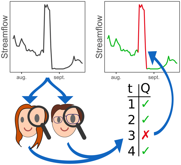
We present the results of a large visual inspection campaign of 674 streamflow time series in France. The objective was to detect non-natural records resulting from instrument failure or anthropogenic influences, such as hydroelectric power generation or reservoir management. We conclude that the identification of flaws in flow time series is highly dependent on the objectives and skills of individual evaluators, and we raise the need for better practices for data cleaning.

Malak Sadki, Simon Munier, Aaron Boone, and Sophie Ricci
Geosci. Model Dev., 16, 427–448, https://doi.org/10.5194/gmd-16-427-2023, https://doi.org/10.5194/gmd-16-427-2023, 2023
Short summary
Short summary
Predicting water resource evolution is a key challenge for the coming century.
Anthropogenic impacts on water resources, and particularly the effects of dams and reservoirs on river flows, are still poorly known and generally neglected in global hydrological studies. A parameterized reservoir model is reproduced to compute monthly releases in Spanish anthropized river basins. For global application, an exhaustive sensitivity analysis of the model parameters is performed on flows and volumes.
Alexis Jeantet, Jean-Pierre Vergnes, Simon Munier, and Florence Habets
Hydrol. Earth Syst. Sci., 30, 6381–6420, https://doi.org/10.5194/hess-30-6381-2026, https://doi.org/10.5194/hess-30-6381-2026, 2026
Short summary
Short summary
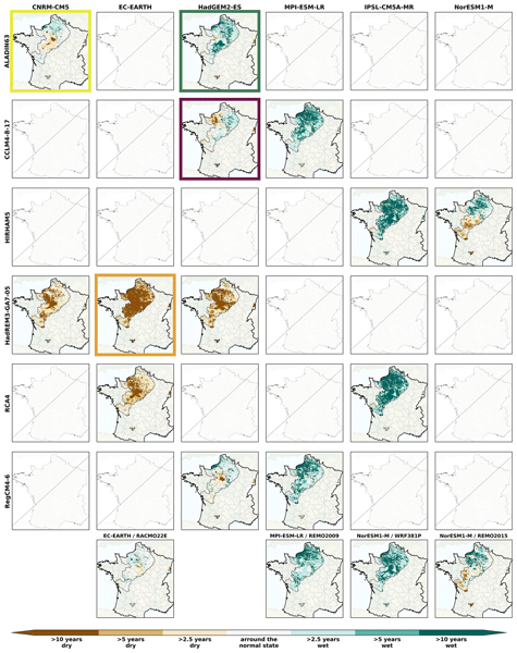
The AquiFR hydrogeological platform, forced by 36 climate projections, simulates future groundwater levels across France. Results reveal significant variability between climate and representative concentration pathways used as socio-economic scenarios, with a dominant signal of rising groundwater levels over most of the study area. Four storylines, representing worst-case scenarios, are selected to inform decision-makers and support the adoption of sustainable groundwater management policies.
Julien Lefebve, Sylvain Biancamaria, Alejandro Blazquez, Simon Munier, Laetitia Gal, Rômulo Augusto Jucá Oliveira, and Jordi Etchanchu
EGUsphere, https://doi.org/10.5194/egusphere-2026-4569, https://doi.org/10.5194/egusphere-2026-4569, 2026
Short summary
Short summary
Approaching the water budget closure of a basin gives confidence in our understanding of its water cycle. By analysing 82 major basins worldwide with the most up‑to‑date data, we demonstrate that the large spread in precipitation (44 %), evapotranspiration (33 %) and runoff (36 %) can produce compensations and lead to erroneous conclusions about water budget closure. In the absence of gauge records, calculating discharge from satellite observations rather than from models reduces these errors.
Pierre Laluet, Jacopo Dari, Louise Busschaert, Zdenko Heyvaert, Gabrielle De Lannoy, Pia Langhans, Sara Modanesi, Christian Massari, Luca Brocca, Carla Saltalippi, Renato Morbidelli, Clément Albergel, and Wouter Dorigo
Earth Syst. Sci. Data, 18, 4833–4853, https://doi.org/10.5194/essd-18-4833-2026, https://doi.org/10.5194/essd-18-4833-2026, 2026
Short summary
Short summary
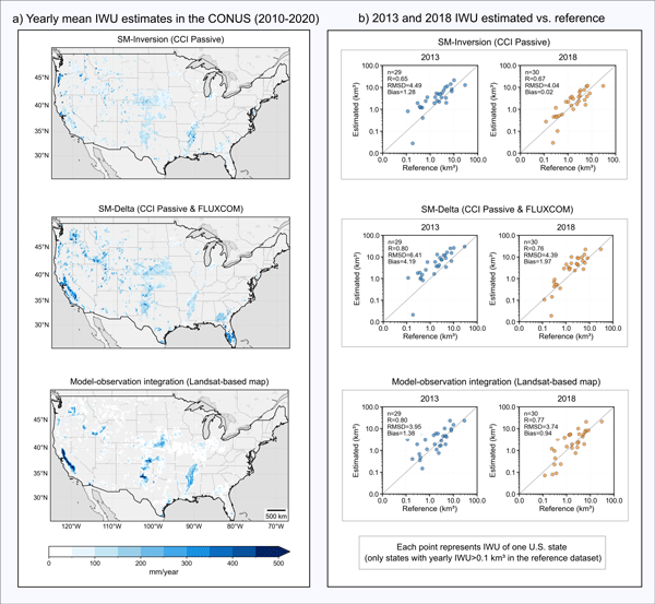
We developed a long-term dataset collection of irrigation water use based on about two decades of satellite observations, three distinct approaches, and many input datasets. The collection provides monthly estimates for major agricultural regions and helps describe how irrigation varies across locations, seasons, and years. It offers a foundation for improving how irrigation is quantified, compared across methods, and integrated into large-scale hydrological and climate studies.
Adrien Manlay, Jean-Pierre Vergnes, Simon Munier, and Florence Habets
EGUsphere, https://doi.org/10.5194/egusphere-2026-1504, https://doi.org/10.5194/egusphere-2026-1504, 2026
Short summary
Short summary
Groundwater is a key resource for human activities, predicting its evolution months in advance poses a significant challenge. Forecasts can be erroneous due to model uncertainties. In this study, we developed a method that integrates observed groundwater levels into a numerical model to improve seasonal forecasts. By continuously updating the model with observations, we achieved more accurate water level simulations and predictions up to six months ahead.
Eric Sauquet, Guillaume Evin, Sonia Siauve, Ryma Aissat, Patrick Arnaud, Maud Bérel, Jérémie Bonneau, Flora Branger, Yvan Caballero, François Colléoni, Agnès Ducharne, Joël Gailhard, Florence Habets, Frédéric Hendrickx, Louis Héraut, Benoît Hingray, Peng Huang, Tristan Jaouen, Alexis Jeantet, Sandra Lanini, Matthieu Le Lay, Claire Magand, Louise Mimeau, Céline Monteil, Simon Munier, Charles Perrin, Olivier Robelin, Fabienne Rousset, Jean-Michel Soubeyroux, Laurent Strohmenger, Guillaume Thirel, Flore Tocquer, Yves Tramblay, Jean-Pierre Vergnes, and Jean-Philippe Vidal
Hydrol. Earth Syst. Sci., 30, 2277–2300, https://doi.org/10.5194/hess-30-2277-2026, https://doi.org/10.5194/hess-30-2277-2026, 2026
Short summary
Short summary
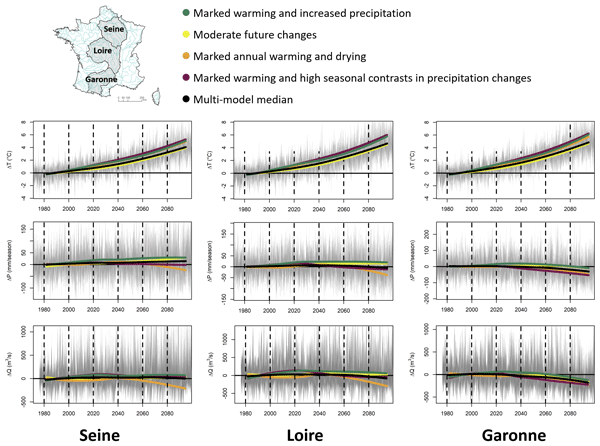
The Explore2 project has provided an unprecedented set of hydrological projections in terms of the number of hydrological models used and the spatial and temporal resolution. The results have been made available through various media. Under the high-emission scenario, the hydrological models mostly agree on the decrease in seasonal flows in the south of France, confirming its hotspot status, and on the decrease in summer flows throughout France, with the exception of the northern part of France.
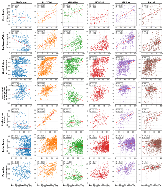
Pierre Laluet, Chiara Corbari, Oscar Baez-Villanueva, Sophia Walther, Yongqiang Zhang, Joaquín Muñoz-Sabater, Clément Albergel, and Wouter Dorigo
Hydrol. Earth Syst. Sci., 30, 1779–1799, https://doi.org/10.5194/hess-30-1779-2026, https://doi.org/10.5194/hess-30-1779-2026, 2026
Short summary
Short summary
We examined how well global datasets estimate evapotranspiration, the water moving from land to the air, in irrigated areas. We compared six widely used products with irrigation maps, satellite estimates, and field measurements across different climate regions. Some datasets better capture irrigation effects, especially those using temperature and vegetation satellite data. This work helps guide dataset selection and supports better inclusion of irrigation in hydrological and climate models.
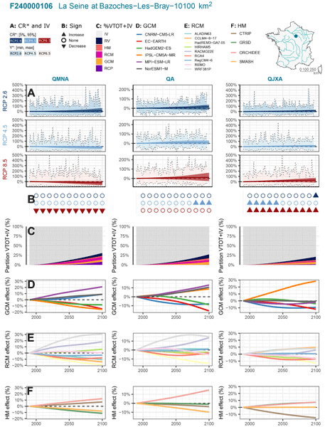
Guillaume Evin, Benoit Hingray, Guillaume Thirel, Agnès Ducharne, Laurent Strohmenger, Lola Corre, Yves Tramblay, Jean-Philippe Vidal, Jérémie Bonneau, François Colleoni, Joël Gailhard, Florence Habets, Frédéric Hendrickx, Louis Héraut, Peng Huang, Matthieu Le Lay, Claire Magand, Paola Marson, Céline Monteil, Simon Munier, Alix Reverdy, Jean-Michel Soubeyroux, Yoann Robin, Jean-Pierre Vergnes, Mathieu Vrac, and Eric Sauquet
Hydrol. Earth Syst. Sci., 30, 1023–1051, https://doi.org/10.5194/hess-30-1023-2026, https://doi.org/10.5194/hess-30-1023-2026, 2026
Short summary
Short summary
Explore2 provides hydrological projections for 1,735 French catchments. Using QUALYPSO (Quasi-Ergodic Analysis of Climate Projections Using Data Augmentation), this study assesses uncertainties, including internal variability. By the end of the century, low flows are projected to decline in southern France under high emissions, while other indicators remain uncertain. Emission scenarios and regional climate models are key uncertainty sources. Internal variability is often as large as climate-driven changes.
Kaushlendra Verma and Simon Munier
EGUsphere, https://doi.org/10.5194/egusphere-2026-509, https://doi.org/10.5194/egusphere-2026-509, 2026
Short summary
Short summary
Satellite provide river observations as vector reaches, while large-scale hydrological models represent rivers on gridded routing networks. This structural mismatch limits direct data assimilation. We present a global, confidence-aware framework that assigns vector river reaches to routing pixels using geometric and hydrological consistency criteria. Results show that most routing pixels can be assigned with high confidence while preserving basin-scale drainage topology into hydrological models.
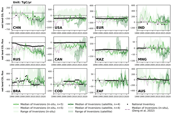
Zhu Deng, Philippe Ciais, Liting Hu, Adrien Martinez, Marielle Saunois, Rona L. Thompson, Kushal Tibrewal, Wouter Peters, Brendan Byrne, Giacomo Grassi, Paul I. Palmer, Ingrid T. Luijkx, Zhu Liu, Junjie Liu, Xuekun Fang, Tengjiao Wang, Hanqin Tian, Katsumasa Tanaka, Ana Bastos, Stephen Sitch, Benjamin Poulter, Clément Albergel, Aki Tsuruta, Shamil Maksyutov, Rajesh Janardanan, Yosuke Niwa, Bo Zheng, Joël Thanwerdas, Dmitry Belikov, Arjo Segers, and Frédéric Chevallier
Earth Syst. Sci. Data, 17, 1121–1152, https://doi.org/10.5194/essd-17-1121-2025, https://doi.org/10.5194/essd-17-1121-2025, 2025
Short summary
Short summary
This study reconciles national greenhouse gas (GHG) inventories with updated atmospheric inversion results to evaluate discrepancies for three principal GHG fluxes at the national level. Compared to our previous study, new satellite-based CO2 inversions were included and an updated mask of managed lands was used, improving agreement for Brazil and Canada. The proposed methodology can be regularly applied as a check to assess the gap between top-down inversions and bottom-up inventories.
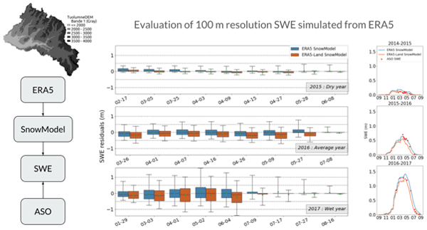
Laura Sourp, Simon Gascoin, Lionel Jarlan, Vanessa Pedinotti, Kat J. Bormann, and Mohamed Wassim Baba
Hydrol. Earth Syst. Sci., 29, 597–611, https://doi.org/10.5194/hess-29-597-2025, https://doi.org/10.5194/hess-29-597-2025, 2025
Short summary
Short summary
Accurate knowledge of the spatial distribution of snow masses across landscapes is important for water management in mountain catchments. We present a new tool for estimating snow water resources without ground measurements. We evaluate the output of this tool using accurate airborne measurements in the Sierra Nevada and find that it provides realistic estimates of snow mass and snow depth at the catchment scale.
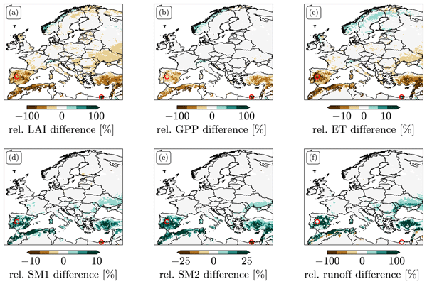
Samuel Scherrer, Gabriëlle De Lannoy, Zdenko Heyvaert, Michel Bechtold, Clement Albergel, Tarek S. El-Madany, and Wouter Dorigo
Hydrol. Earth Syst. Sci., 27, 4087–4114, https://doi.org/10.5194/hess-27-4087-2023, https://doi.org/10.5194/hess-27-4087-2023, 2023
Short summary
Short summary
We explored different options for data assimilation (DA) of the remotely sensed leaf area index (LAI). We found strong biases between LAI predicted by Noah-MP and observations. LAI DA that does not take these biases into account can induce unphysical patterns in the resulting LAI and flux estimates and leads to large changes in the climatology of root zone soil moisture. We tested two bias-correction approaches and explored alternative solutions to treating bias in LAI DA.
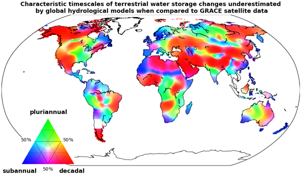
Julia Pfeffer, Anny Cazenave, Alejandro Blazquez, Bertrand Decharme, Simon Munier, and Anne Barnoud
Hydrol. Earth Syst. Sci., 27, 3743–3768, https://doi.org/10.5194/hess-27-3743-2023, https://doi.org/10.5194/hess-27-3743-2023, 2023
Short summary
Short summary
The GRACE (Gravity Recovery And Climate Experiment) satellite mission enabled the quantification of water mass redistributions from 2002 to 2017. The analysis of GRACE satellite data shows here that slow changes in terrestrial water storage occurring over a few years to a decade are severely underestimated by global hydrological models. Several sources of errors may explain such biases, likely including the inaccurate representation of groundwater storage changes.
Laurent Strohmenger, Eric Sauquet, Claire Bernard, Jérémie Bonneau, Flora Branger, Amélie Bresson, Pierre Brigode, Rémy Buzier, Olivier Delaigue, Alexandre Devers, Guillaume Evin, Maïté Fournier, Shu-Chen Hsu, Sandra Lanini, Alban de Lavenne, Thibault Lemaitre-Basset, Claire Magand, Guilherme Mendoza Guimarães, Max Mentha, Simon Munier, Charles Perrin, Tristan Podechard, Léo Rouchy, Malak Sadki, Myriam Soutif-Bellenger, François Tilmant, Yves Tramblay, Anne-Lise Véron, Jean-Philippe Vidal, and Guillaume Thirel
Hydrol. Earth Syst. Sci., 27, 3375–3391, https://doi.org/10.5194/hess-27-3375-2023, https://doi.org/10.5194/hess-27-3375-2023, 2023
Short summary
Short summary
We present the results of a large visual inspection campaign of 674 streamflow time series in France. The objective was to detect non-natural records resulting from instrument failure or anthropogenic influences, such as hydroelectric power generation or reservoir management. We conclude that the identification of flaws in flow time series is highly dependent on the objectives and skills of individual evaluators, and we raise the need for better practices for data cleaning.
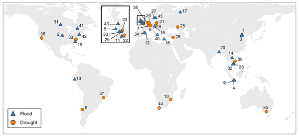
Heidi Kreibich, Kai Schröter, Giuliano Di Baldassarre, Anne F. Van Loon, Maurizio Mazzoleni, Guta Wakbulcho Abeshu, Svetlana Agafonova, Amir AghaKouchak, Hafzullah Aksoy, Camila Alvarez-Garreton, Blanca Aznar, Laila Balkhi, Marlies H. Barendrecht, Sylvain Biancamaria, Liduin Bos-Burgering, Chris Bradley, Yus Budiyono, Wouter Buytaert, Lucinda Capewell, Hayley Carlson, Yonca Cavus, Anaïs Couasnon, Gemma Coxon, Ioannis Daliakopoulos, Marleen C. de Ruiter, Claire Delus, Mathilde Erfurt, Giuseppe Esposito, Didier François, Frédéric Frappart, Jim Freer, Natalia Frolova, Animesh K. Gain, Manolis Grillakis, Jordi Oriol Grima, Diego A. Guzmán, Laurie S. Huning, Monica Ionita, Maxim Kharlamov, Dao Nguyen Khoi, Natalie Kieboom, Maria Kireeva, Aristeidis Koutroulis, Waldo Lavado-Casimiro, Hong-Yi Li, Maria Carmen LLasat, David Macdonald, Johanna Mård, Hannah Mathew-Richards, Andrew McKenzie, Alfonso Mejia, Eduardo Mario Mendiondo, Marjolein Mens, Shifteh Mobini, Guilherme Samprogna Mohor, Viorica Nagavciuc, Thanh Ngo-Duc, Huynh Thi Thao Nguyen, Pham Thi Thao Nhi, Olga Petrucci, Nguyen Hong Quan, Pere Quintana-Seguí, Saman Razavi, Elena Ridolfi, Jannik Riegel, Md Shibly Sadik, Nivedita Sairam, Elisa Savelli, Alexey Sazonov, Sanjib Sharma, Johanna Sörensen, Felipe Augusto Arguello Souza, Kerstin Stahl, Max Steinhausen, Michael Stoelzle, Wiwiana Szalińska, Qiuhong Tang, Fuqiang Tian, Tamara Tokarczyk, Carolina Tovar, Thi Van Thu Tran, Marjolein H. J. van Huijgevoort, Michelle T. H. van Vliet, Sergiy Vorogushyn, Thorsten Wagener, Yueling Wang, Doris E. Wendt, Elliot Wickham, Long Yang, Mauricio Zambrano-Bigiarini, and Philip J. Ward
Earth Syst. Sci. Data, 15, 2009–2023, https://doi.org/10.5194/essd-15-2009-2023, https://doi.org/10.5194/essd-15-2009-2023, 2023
Short summary
Short summary
As the adverse impacts of hydrological extremes increase in many regions of the world, a better understanding of the drivers of changes in risk and impacts is essential for effective flood and drought risk management. We present a dataset containing data of paired events, i.e. two floods or two droughts that occurred in the same area. The dataset enables comparative analyses and allows detailed context-specific assessments. Additionally, it supports the testing of socio-hydrological models.
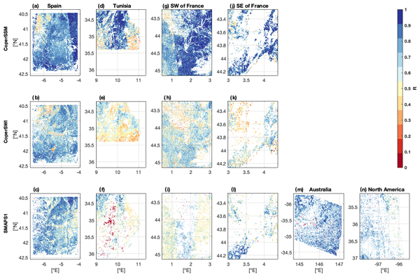
Remi Madelon, Nemesio J. Rodríguez-Fernández, Hassan Bazzi, Nicolas Baghdadi, Clement Albergel, Wouter Dorigo, and Mehrez Zribi
Hydrol. Earth Syst. Sci., 27, 1221–1242, https://doi.org/10.5194/hess-27-1221-2023, https://doi.org/10.5194/hess-27-1221-2023, 2023
Short summary
Short summary
We present an approach to estimate soil moisture (SM) at 1 km resolution using Sentinel-1 and Sentinel-3 satellites. The estimates were compared to other high-resolution (HR) datasets over Europe, northern Africa, Australia, and North America, showing good agreement. However, the discrepancies between the different HR datasets and their lower performances compared with in situ measurements and coarse-resolution datasets show the remaining challenges for large-scale HR SM mapping.
Malak Sadki, Simon Munier, Aaron Boone, and Sophie Ricci
Geosci. Model Dev., 16, 427–448, https://doi.org/10.5194/gmd-16-427-2023, https://doi.org/10.5194/gmd-16-427-2023, 2023
Short summary
Short summary
Predicting water resource evolution is a key challenge for the coming century.
Anthropogenic impacts on water resources, and particularly the effects of dams and reservoirs on river flows, are still poorly known and generally neglected in global hydrological studies. A parameterized reservoir model is reproduced to compute monthly releases in Spanish anthropized river basins. For global application, an exhaustive sensitivity analysis of the model parameters is performed on flows and volumes.
Arsène Druel, Simon Munier, Anthony Mucia, Clément Albergel, and Jean-Christophe Calvet
Geosci. Model Dev., 15, 8453–8471, https://doi.org/10.5194/gmd-15-8453-2022, https://doi.org/10.5194/gmd-15-8453-2022, 2022
Short summary
Short summary
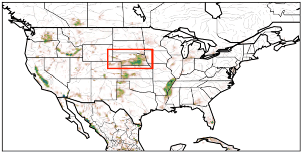
Crop phenology and irrigation is implemented into a land surface model able to work at a global scale. A case study is presented over Nebraska (USA). Simulations with and without the new scheme are compared to different satellite-based observations. The model is able to produce a realistic yearly irrigation water amount. The irrigation scheme improves the simulated leaf area index, gross primary productivity, evapotransipiration, and land surface temperature.
Robin van der Schalie, Mendy van der Vliet, Clément Albergel, Wouter Dorigo, Piotr Wolski, and Richard de Jeu
Hydrol. Earth Syst. Sci., 26, 3611–3627, https://doi.org/10.5194/hess-26-3611-2022, https://doi.org/10.5194/hess-26-3611-2022, 2022
Short summary
Short summary
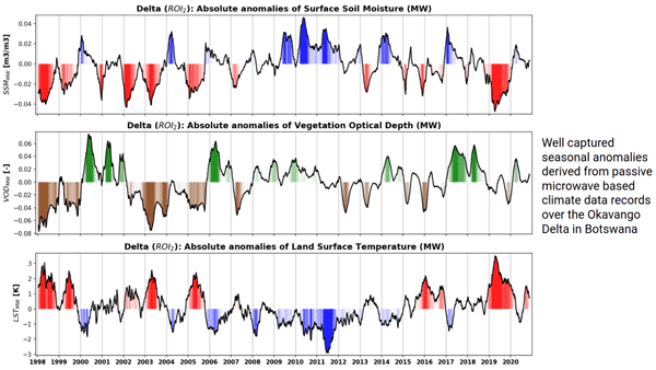
Climate data records of surface soil moisture, vegetation optical depth, and land surface temperature can be derived from passive microwave observations. The ability of these datasets to properly detect anomalies and extremes is very valuable in climate research and can especially help to improve our insight in complex regions where the current climate reanalysis datasets reach their limitations. Here, we present a case study over the Okavango Delta, where we focus on inter-annual variability.
Anthony Mucia, Bertrand Bonan, Clément Albergel, Yongjun Zheng, and Jean-Christophe Calvet
Biogeosciences, 19, 2557–2581, https://doi.org/10.5194/bg-19-2557-2022, https://doi.org/10.5194/bg-19-2557-2022, 2022
Short summary
Short summary
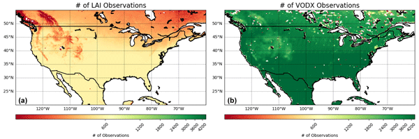
For the first time, microwave vegetation optical depth data are assimilated in a land surface model in order to analyze leaf area index and root zone soil moisture. The advantage of microwave products is the higher observation frequency. A large variety of independent datasets are used to verify the added value of the assimilation. It is shown that the assimilation is able to improve the representation of soil moisture, vegetation conditions, and terrestrial water and carbon fluxes.

Simon Munier and Bertrand Decharme
Earth Syst. Sci. Data, 14, 2239–2258, https://doi.org/10.5194/essd-14-2239-2022, https://doi.org/10.5194/essd-14-2239-2022, 2022
Short summary
Short summary
This paper presents a new global-scale river network at 1/12°, generated automatically and assessed over the 69 largest basins of the world. A set of hydro-geomorphological parameters are derived at the same spatial resolution, including a description of river stretches (length, slope, width, roughness, bankfull depth), floodplains (roughness, sub-grid topography) and aquifers (transmissivity, porosity, sub-grid topography). The dataset may be useful for hydrology modelling or climate studies.
Zhu Deng, Philippe Ciais, Zitely A. Tzompa-Sosa, Marielle Saunois, Chunjing Qiu, Chang Tan, Taochun Sun, Piyu Ke, Yanan Cui, Katsumasa Tanaka, Xin Lin, Rona L. Thompson, Hanqin Tian, Yuanzhi Yao, Yuanyuan Huang, Ronny Lauerwald, Atul K. Jain, Xiaoming Xu, Ana Bastos, Stephen Sitch, Paul I. Palmer, Thomas Lauvaux, Alexandre d'Aspremont, Clément Giron, Antoine Benoit, Benjamin Poulter, Jinfeng Chang, Ana Maria Roxana Petrescu, Steven J. Davis, Zhu Liu, Giacomo Grassi, Clément Albergel, Francesco N. Tubiello, Lucia Perugini, Wouter Peters, and Frédéric Chevallier
Earth Syst. Sci. Data, 14, 1639–1675, https://doi.org/10.5194/essd-14-1639-2022, https://doi.org/10.5194/essd-14-1639-2022, 2022
Short summary
Short summary
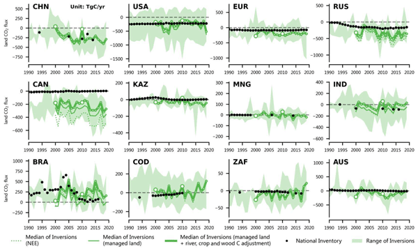
In support of the global stocktake of the Paris Agreement on climate change, we proposed a method for reconciling the results of global atmospheric inversions with data from UNFCCC national greenhouse gas inventories (NGHGIs). Here, based on a new global harmonized database that we compiled from the UNFCCC NGHGIs and a comprehensive framework presented in this study to process the results of inversions, we compared their results of carbon dioxide (CO2), methane (CH4), and nitrous oxide (N2O).
Cited articles
Andersen, I. and Golitzen, K. G. (Eds.): The Niger river basin: A vision for sustainable management, World Bank Publications, https://hdl.handle.net/10986/7397 (last access: 28 September 2026), https://doi.org/10.1596/978-0-8213-6203-7, 2005. a
Andreadis, K. M., Clark, E. A., Lettenmaier, D. P., and Alsdorf, D. E.: Prospects for river discharge and depth estimation through assimilation of swath-altimetry into a raster-based hydrodynamics model, Geophys. Res. Lett., 34, L10403, https://doi.org/10.1029/2007GL029721, 2007. a
Bele, M. Y., Sonwa, D. J., and Tiani, A. M.: Local communities' vulnerability to climate change and adaptation strategies in Bukavu in DR Congo, The J. Environ. Develop., 23, 331–357, https://doi.org/10.1177/1070496514536395, 2014. a
Biancamaria, S., Durand, M., Andreadis, K. M., Bates, P. D., Boone, A., Mognard, N. M., Rodriguez, E., Alsdorf, D. E., Lettenmaier, D. P., and Clark, E. A.: Assimilation of virtual wide-swath altimetry to improve Arctic river modeling, Remote Sens. Environ., 115, 373–381, https://doi.org/10.1016/j.rse.2010.09.008, 2011.
Biancamaria, S., Frappart, F., Leleu, A.-S., Marieu, V., Blumstein, D., Desjonquères, J.-D., Boy, F., Sottolichio, A., and Valle-Levinson, A.: Satellite radar altimetry water elevations performance over a 200 m wide river: evaluation over the Garonne River, Adv. Space Res., 59, 128–146, https://doi.org/10.1016/j.asr.2016.10.008, 2017. a
Biancamaria, S., Blumstein, D., Tourian, M. J., Darrozes, J., Frappart, F., Paris, A., and Grusson, Y.: D3. Water Surface Elevation (WSE) ATBD, CCI River Discharge precursor project, CCI-Discharge-0009-ATBD-WSE v1-2, European Space Agency, https://climate.esa.int/media/documents/CCI-Discharge-0009-ATBD-WSE_v1-2.pdf (last access: 20 August 2026), 2023. a
Biancamaria, S., Gal, L., Zakharova, E., Kitambo, B., and Vayre, M.: D3. Water Surface Elevation (WSE) Algorithm Theoretical Basis Document (ATBD), CCI River Discharge precursor project technical document, Issue 1.2, available at: https://climate.esa.int/media/documents/CCI-Discharge-0009-ATBD-WSE_v1-2.pdf (last access: 20 August 2026), 2024. a
Clark, M. P., Slater, A. G., Rupp, D. E., Woods, R. A., Vrugt, J. A., Gupta, H. V., Wagener, T., and Hay, L. E.: Framework for Understanding Structural Errors (FUSE): A modular framework to diagnose differences between hydrological models, Water Resour. Res., 44, W00B02, https://doi.org/10.1029/2007WR006735, 2008. a
Collischonn, W., Allasia, D., Da Silva, B. C., and Tucci, C. E. M.: The MGB-IPH model for large-scale rainfall–runoff modelling, Hydrol. Sci. J., 52, 878–895, https://doi.org/10.1623/hysj.52.5.878, 2007. a, b, c, d
Decharme, B., Delire, C., Minvielle, M., Colin, J., Vergnes, J.-P., Alias, A., Saint-Martin, D., Séférian, R., Sénési, S., and Voldoire, A.: Recent changes in the ISBA-CTRIP land surface system for use in the CNRM-CM6 climate model and in global off-line hydrological applications, J. Adv. Model. Earth Syst., 11, 1207–1252, https://doi.org/10.1029/2018MS001545, 2019. a, b, c, d
Dee, D. P., Uppala, S. M., Simmons, A. J., Berrisford, P., Poli, P., Kobayashi, S., Andrae, U., Balmaseda, M. A., Balsamo, G., Bauer, P., Bechtold, P., Beljaars, A. C. M., Van De Berg, L., Bidlot, J., Bormann, N., Delsol, C., Dragani, R., Fuentes, M., Geer, A. J., and Vitart, F.: The ERA-Interim reanalysis: Configuration and performance of the data assimilation system, Q. J. Roy. Meteorol. Soc., 137, 553–597, https://doi.org/10.1002/qj.828, 2011. a
De Paiva, R. C. D., Buarque, D. C., Collischonn, W., Bonnet, M. P., Frappart, F., Calmant, S., and Bulhões Mendes, C. A.: Large-scale hydrologic and hydrodynamic modeling of the Amazon River basin, Water Resour. Res., 49, 1226–1243, https://doi.org/10.1002/wrcr.20067, 2013. a, b, c, d
Emery, C. M., Paris, A., Biancamaria, S., Boone, A., Calmant, S., Garambois, P.-A., and Santos da Silva, J.: Large-scale hydrological model river storage and discharge correction using a satellite altimetry-based discharge product, Hydrol. Earth Syst. Sci., 22, 2135–2162, https://doi.org/10.5194/hess-22-2135-2018, 2018. a, b, c
Emery, C. M., Biancamaria, S., Boone, A., Ricci, S., Rochoux, M. C., Pedinotti, V., and David, C. H.: Assimilation of wide-swath altimetry water elevation anomalies to correct large-scale river routing model parameters, Hydrol. Earth Syst. Sci., 24, 2207–2233, https://doi.org/10.5194/hess-24-2207-2020, 2020a. a
Emery, C. M., Paris, A., Biancamaria, S., Boone, A., Calmant, S., Garambois, P. A., Santos da Silva, J., and David, C. H.: Discharge estimation via assimilation of multisatellite-based discharge products: Case study over the Amazon Basin, IEEE Geosci. Remote Sens. Lett., 19, 1–5, https://doi.org/10.1109/LGRS.2020.3020285, 2020b. a
European Space Agency: Algorithm Theoretical Basis Document (ATBD) for River Discharge, CCI+ Phase 1, available at: https://climate.esa.int/media/documents/CCI-Discharge-0012-ATBD-Discharge.pdf (last access: 20 August 2026), 2023. a
Evensen, G.: Data assimilation: The ensemble Kalman filter, Springer Berlin Heidelberg, Berlin, Heidelberg, https://doi.org/10.1007/978-3-642-03711-5, 2009. a
Eyring, V., Bony, S., Meehl, G. A., Senior, C. A., Stevens, B., Stouffer, R. J., and Taylor, K. E.: Overview of the Coupled Model Intercomparison Project Phase 6 (CMIP6) experimental design and organization, Geosci. Model Dev., 9, 1937–1958, https://doi.org/10.5194/gmd-9-1937-2016, 2016. a
Filippucci, P., Brocca, L., Bonafoni, S., Saltalippi, C., Wagner, W., and Tarpanelli, A.: Sentinel-2 high-resolution data for river discharge monitoring, Remote Sens. Environ., 281, 113255, https://doi.org/10.1016/j.rse.2022.113255, 2022. a
Funk, C., Peterson, P., Landsfeld, M., Pedreros, D., Verdin, J., Shukla, S., Husak, G., Rowland, J., Harrison, L., Hoell, A., and Michaelsen, J.: The climate hazards infrared precipitation with stations – a new environmental record for monitoring extremes, Sci. Data, 2, 150066, https://doi.org/10.1038/sdata.2015.66, 2015. a
Gal, L., Tarpanelli, A., and Filippucci, P.: D3. River Discharge (Q) from Altimeters and Ancillary data, multispectral images and data combination – Algorithm Theoretical Basis Document (ATBD), CCI River Discharge precursor project technical document, CCI-Discharge-0012-ATBD, Issue 1.2, https://climate.esa.int/fr/projects/river-discharge/ (last access: 20 August 2026), 2024a. a, b, c
Gal, L., Filippucci, P., and Biancamaria, S.: D10. Product User Guide (PUG), CCI River Discharge precursor project technical document, D10_RD-CCI_0023_PUG, Issue 2.0, available at: https://climate.esa.int/fr/projects/river-discharge/ (last access: 20 August 2026), 2024b. a
Getirana, A., Jung, H. C., Arsenault, K., Shukla, S., Kumar, S., Peters-Lidard, C., and Mamane, B.: Satellite gravimetry improves seasonal streamflow forecast initialization in Africa, Water Resour. Res., 56, e2019WR026259, https://doi.org/10.1029/2019WR026259, 2020. a
Gosset, M., Dibi-Anoh, P. A., Schumann, G., Hostache, R., Paris, A., Zahiri, E.-P., Kacou, M., and Gal, L.: Hydrometeorological Extreme Events in Africa: The Role of Satellite Observations for Monitoring Pluvial and Fluvial Flood Risk, Surv. Geophys., 44, 197–223, https://doi.org/10.1007/s10712-022-09749-6, 2023. a
Hersbach, H., Bell, B., Berrisford, P., Hirahara, S., Horányi, A., Muñoz-Sabater, J., Nicolas, J., Peubey, C., Radu, R., Schepers, D., Simmons, A., Soci, C., Abdalla, S., Abellan, X., Balsamo, G., Bechtold, P., Biavati, G., Bidlot, J., Bonavita, M., and Thépaut, J.: The ERA5 global reanalysis, Q. J. Roy. Meteorol. So., 146, 1999–2049, https://doi.org/10.1002/qj.3803, 2020. a, b
Huffman, G. J., Stocker, E. F., Bolvin, D. T., Nelkin, E. J., and Tan, J.: GPM IMERG final precipitation L3 1 month 0.1° × 0.1° V06, Goddard Earth Sciences Data and Information Services Center (GES DISC), Greenbelt, MD [data set], https://doi.org/10.5067/GPM/IMERG/3B-MONTH/06 (last access: 28 September 2026), 2019. a, b, c
Kalman, R. E.: A new approach to linear filtering and prediction problems, J. Basic Eng., 82, 35–45, https://doi.org/10.1115/1.3662552, 1960. a
Kouraev, A. V., Zakharova, E. A., Samain, O., Mognard, N. M., and Cazenave, A.: Ob' river discharge from TOPEX/Poseidon satellite altimetry (1992–2002), Remote Sens. Environ., 93, 238–245, https://doi.org/10.1016/j.rse.2004.07.007, 2004. a
Kubota, T., Aonashi, K., Ushio, T., Shige, S., Takayabu, Y. N., Kachi, M., and Oki, R.: Global Satellite Mapping of Precipitation (GSMaP) products in the GPM era, Satellite Precipitation Measurement, 355–373, Springer, https://doi.org/10.1007/978-3-030-24568-9_20, 2020. a
Laraque, A., Moukandi N’kaya, G. D., Orange, D., Tshimanga, R., Tshitenge, J. M., Mahé, G., and Gulemvuga, G.: Recent budget of hydroclimatology and hydrosedimentology of the Congo River in Central Africa, Water, 12, 2613, https://doi.org/10.3390/w12092613, 2020. a
Li, B., Rodell, M., Zaitchik, B. F., Reichle, R. H., Koster, R. D., and van Dam, T. M.: Assimilation of GRACE terrestrial water storage into a land surface model: Evaluation and potential value for drought monitoring in western and central Europe, J. Hydrol., 446, 103–115, https://doi.org/10.1016/j.jhydrol.2012.05.047, 2012. a
Michailovsky, C. I., McEnnis, S., Berry, P. A. M., Smith, R., and Bauer-Gottwein, P.: River monitoring from satellite radar altimetry in the Zambezi River basin, Hydrol. Earth Syst. Sci., 16, 2181–2192, https://doi.org/10.5194/hess-16-2181-2012, 2012. a
Munier, S. and Decharme, B.: River network and hydro-geomorphological parameters at 1∕12° resolution for global hydrological and climate studies, Earth Syst. Sci. Data, 14, 2239–2258, https://doi.org/10.5194/essd-14-2239-2022, 2022. a, b
Munier, S., Polebistki, A., Brown, C., Belaud, G., and Lettenmaier, D. P.: SWOT data assimilation for operational reservoir management on the upper Niger River Basin, Water Resour. Res., 51, 554–575, https://doi.org/10.1002/2014WR016157, 2015. a, b, c
Munier, S., Boone, A., Biancamaria, S., and Le Moigne, P.: Assimilation of SWOT discharge versus water level into CTRIP-12D over the Congo Basin, Proceedings of the IAHS Scientific Assembly 2022, Montpellier, France, 29 May–3 June 2022, https://doi.org/10.5194/iahs2022-657, 2022. a
New, M., Lister, D., Hulme, M., and Makin, I.: A high-resolution data set of surface climate over global land areas, Clim. Res., 21, 1–25, https://doi.org/10.3354/cr021001, 2002. a
Oubanas, H., Gejadze, I., Malaterre, P.-O., Durand, M., Wei, R., Frasson, R. P., and Domeneghetti, A.: Discharge estimation in ungauged basins through variational data assimilation: The potential of the SWOT mission, Water Resour. Res., 54, 2405–2423, https://doi.org/10.1002/2017WR021735, 2018. a, b
Paiva, R. C. D., Collischonn, W., Bonnet, M.-P., de Gonçalves, L. G. G., Calmant, S., Getirana, A., and Santos da Silva, J.: Assimilating in situ and radar altimetry data into a large-scale hydrologic-hydrodynamic model for streamflow forecast in the Amazon, Hydrol. Earth Syst. Sci., 17, 2929–2946, https://doi.org/10.5194/hess-17-2929-2013, 2013. a, b, c, d
Paiva, R. C. D., Durand, M. T., and Hossain, F.: Spatiotemporal interpolation of discharge across a river network by using synthetic SWOT satellite data, Water Resour. Res., 51, 430–449, https://doi.org/10.1002/2014WR015618, 2015. a, b
Paris, A., Dias de Paiva, R., Santos da Silva, J., Medeiros Moreira, D., Calmant, S., Garambois, P. A., and Seyler, F.: Stage-discharge rating curves based on satellite altimetry and modeled discharge in the Amazon basin, Water Resour. Res., 52, 3787–3814, https://doi.org/10.1002/2014WR016618, 2016. a
Pedinotti, V., Boone, A., Decharme, B., Crétaux, J. F., Mognard, N., Panthou, G., Papa, F., and Tanimoun, B. A.: Evaluation of the ISBA-TRIP continental hydrologic system over the Niger basin using in situ and satellite derived datasets, Hydrol. Earth Syst. Sci., 16, 1745–1773, https://doi.org/10.5194/hess-16-1745-2012, 2012. a, b
Pontes, P. R. M., Fan, F. M., Fleischmann, A. S., de Paiva, R. C. D., Buarque, D. C., Siqueira, V. A., and Collischonn, W.: MGB-IPH model for hydrological and hydraulic simulation of large floodplain river systems coupled with open source GIS, Environ. Modell. Softw., 94, 1–20, https://doi.org/10.1016/j.envsoft.2017.03.029, 2017. a, b, c, d
Revel, M., Ikeshima, D., Yamazaki, D., and Kanae, S.: A physically based empirical localization method for assimilating synthetic SWOT observations of a continental-scale river: A case study in the Congo basin, Water, 11, 829, https://doi.org/10.3390/w11040829, 2019. a, b, c
Revel, M., Zhou, X., Yamazaki, D., and Kanae, S.: Assimilation of transformed water surface elevation to improve river discharge estimation in a continental-scale river, Hydrol. Earth Syst. Sci., 27, 647–671, https://doi.org/10.5194/hess-27-647-2023, 2023. a
Siqueira, V. A., Paiva, R. C. D., Fleischmann, A. S., Fan, F. M., Ruhoff, A. L., Pontes, P. R. M., Paris, A., Calmant, S., and Collischonn, W.: Toward continental hydrologic–hydrodynamic modeling in South America, Hydrol. Earth Syst. Sci., 22, 4815–4842, https://doi.org/10.5194/hess-22-4815-2018, 2018. a, b, c
Sorribas, M. V., Paiva, R. C. D., Fleischmann, A. S., and Collischonn, W.: Hydrological tracking model for Amazon surface waters, Water Resour. Res., 56, e2019WR024721, https://doi.org/10.1029/2019WR024721, 2020. a
Szczypta, C., Decharme, B., Carrer, D., Calvet, J.-C., Lafont, S., Somot, S., Faroux, S., and Martin, E.: Impact of precipitation and land biophysical variables on the simulated discharge of European and Mediterranean rivers, Hydrol. Earth Syst. Sci., 16, 3351–3370, https://doi.org/10.5194/hess-16-3351-2012, 2012. a, b
Tarpanelli, A., Brocca, L., Lacava, T., Melone, F., Moramarco, T., Faruolo, M., and Pergola, N.: Toward the estimation of river discharge variations using MODIS data in ungauged basins, Remote Sens. Environ., 136, 47–55, https://doi.org/10.1016/j.rse.2013.04.010, 2013. a
Tourian, M. J., Sneeuw, N., and Bárdossy, A.: A quantile function approach to discharge estimation from satellite altimetry (ENVISAT), Water Resour. Res., 49, 4174–4186, https://doi.org/10.1002/wrcr.20348, 2013. a
Tourian, M. J., Schwatke, C., and Sneeuw, N.: River discharge estimation at daily resolution from satellite altimetry over an entire river basin, J. Hydrol., 546, 230–247, https://doi.org/10.1016/j.jhydrol.2017.01.009 , 2017. a
Tourian, M. J., Papa, F., Elmi, O., Sneeuw, N., Kitambo, B., Tshimanga, R. M., Paris, A., and Calmant, S.: Current availability and distribution of Congo Basin's freshwater resources, Commun. Earth Environ., 74, https://doi.org/10.1038/s43247-023-00836-z, 2023. a
Ushio, T., Okamoto, K., Aonashi, K., Inoue, T., Kubota, T., Hashizume, H., Simomura, T., Iguchi, T., Takahashi, N., Oki, R., and Kachi, M.: Combined microwave and infrared radiometer approach for a high resolution global precipitation map in the GSMaP Japan, 3rd International Precipitation Working Group Workshop on Precipitation Measurements, Melbourne, Australia, 23–27 October 2006, 5–11, https://www.eorc.jaxa.jp/IPWG/meetings/melbourne-2006/melbourne2006-pres.html (last access: 28 September 2026), 2006. a, b, c
Vergnes, J. P., Decharme, B., Alkama, R., Martin, E., Habets, F., and Douville, H.: A simple groundwater scheme for hydrological and climate applications: Description and offline evaluation over France, J. Hydrometeorol., 13, 1149–1171, https://doi.org/10.1175/JHM-D-11-0149.1, 2012. a
Wongchuig, S., Paiva, R., Siqueira, V., Papa, F., Fleischmann, A., Biancamaria, S., Paris, A., Parrens, M., and Al Bitar, A.: Multi-satellite data assimilation for large-scale hydrological-hydrodynamic prediction: Proof of concept in the Amazon basin, Water Resour. Res., 60, e2024WR037155, https://doi.org/10.1029/2024WR037155, 2024. a
Wongchuig-Correa, S., de Paiva, R. C. D., Biancamaria, S., and Collischonn, W.: Assimilation of future SWOT-based river elevations, surface extent observations and discharge estimations into uncertain global hydrological models, J. Hydrol., 590, 125473, https://doi.org/10.1016/j.jhydrol.2020.125473, 2020. a, b, c
Yamazaki, D., Ikeshima, D., Sosa, J., Bates, P. D., Allen, G. H., and Pavelsky, T. M.: MERIT Hydro: A high-resolution global hydrography map based on latest topography datasets, Water Resour. Res., 55, 5053–5073, https://doi.org/10.1029/2019WR024873, 2019. a
Zakharova, E., Nielsen, K., Kamenev, G., and Kouraev, A.: River discharge estimation from radar altimetry: Assessment of satellite performance, river scales and methods, J. Hydrol., 583, 124561, https://doi.org/10.1016/j.jhydrol.2020.124561, 2020. a
Zakharova, E., Agafonova, S., Duguay, C., Frolova, N., and Kouraev, A.: River ice phenology and thickness from satellite altimetry: potential for ice bridge road operation and climate studies, The Cryosphere, 15, 5387–5407, https://doi.org/10.5194/tc-15-5387-2021, 2021. a
Short summary
his study explores how 20 years of European Space Agency Climate Change Initiative discharge products improve large-scale hydrological simulations through data assimilation. Tests in two contrasting models across Niger and Congo basins show that temporally dense discharge data reduces bias and improves internal variability. Although product quality, sampling, and basin processes control gain reliability, the findings support these datasets' value in refining models for climate studies.
his study explores how 20 years of European Space Agency Climate Change Initiative discharge...


