
Articles | Volume 30, issue 17
https://doi.org/10.5194/hess-30-5491-2026
© Author(s) 2026. This work is distributed under
the Creative Commons Attribution 4.0 License.
the Creative Commons Attribution 4.0 License.
https://doi.org/10.5194/hess-30-5491-2026
© Author(s) 2026. This work is distributed under
the Creative Commons Attribution 4.0 License.
the Creative Commons Attribution 4.0 License.
Research article
| 
01 Sep 2026
Research article |
| 01 Sep 2026
| 01 Sep 2026
Validation of the open-source hydrodynamic model SFINCS on historical river floods at the global scale

Institute for Environmental Studies (IVM), Vrije Universiteit Amsterdam, Amsterdam, the Netherlands
Jeroen C. J. H. Aerts
Institute for Environmental Studies (IVM), Vrije Universiteit Amsterdam, Amsterdam, the Netherlands
Deltares, Delft, the Netherlands
Dirk Eilander
Institute for Environmental Studies (IVM), Vrije Universiteit Amsterdam, Amsterdam, the Netherlands
Deltares, Delft, the Netherlands
Bruno Merz
GFZ Helmholtz Centre for Geosciences, Potsdam, Germany
Institute for Environmental Sciences and Geography, University of Potsdam, Potsdam, Germany
Hans de Moel
Institute for Environmental Studies (IVM), Vrije Universiteit Amsterdam, Amsterdam, the Netherlands
Tim Busker
Institute for Environmental Studies (IVM), Vrije Universiteit Amsterdam, Amsterdam, the Netherlands
Veerle C. Bril
Institute for Environmental Studies (IVM), Vrije Universiteit Amsterdam, Amsterdam, the Netherlands
Jens de Bruijn
Institute for Environmental Studies (IVM), Vrije Universiteit Amsterdam, Amsterdam, the Netherlands
International Institute for Applied Systems Analysis (IIASA), Laxenburg, Austria
Related authors
No articles found.
Kyunghun Kim, Nivedita Sairam, and Bruno Merz
EGUsphere, https://doi.org/10.5194/egusphere-2026-5526, https://doi.org/10.5194/egusphere-2026-5526, 2026
This preprint is open for discussion and under review for Natural Hazards and Earth System Sciences (NHESS).
Short summary
Short summary
While drought is known to worsen wildfires, how severely it expands fire size remains unclear. Analyzing nearly 12 000 South Korean fire records from 2000 to 2024, we quantified drought impacts across different fire scales. We found that drought expands fire spread, driving up to a 13.7-fold increase in burned area for large scale events. These findings show that dry conditions exponentially worsen wildfires, aiding climate policy.
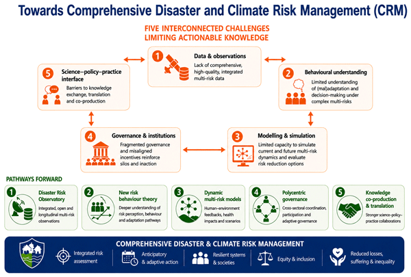
Philip J. Ward, Marleen C. de Ruiter, Kees Boersma, Tomris Cesuroglu, Nathan Clark, Tina Comes, Ashok Dahal, Sonja Fransen, Jasper Verschuur, Carmen Anthonj, Srijith Balakrishnan, Jens de Bruijn, Eefje Hendriks, Rodrigo Mena Fluhmann, Goda Perlaviciute, Linda Steg, Marc J. C. van den Homberg, Cees van Westen, Funda Atun, Anja Schreijer, and Nicole van Maanen
Nat. Hazards Earth Syst. Sci., 26, 4589–4609, https://doi.org/10.5194/nhess-26-4589-2026, https://doi.org/10.5194/nhess-26-4589-2026, 2026
Short summary
Short summary
We explore five core challenges that need to be addressed in order to move towards the Comprehensive Disaster and Climate Risk Management approach. This approach has been proposed within the newly emerging paradigm of a more holistic approach to managing the risks associated with climatic and/or non-climatic hazards and non-climatic risk drivers. We elaborate on each challenge, discuss why they matter for comprehensive disaster risk management, and provide ideas of how to overcome them.
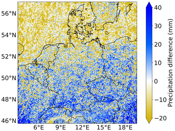
Marc Lennartz, Benjamin Poschlod, and Bruno Merz
Nat. Hazards Earth Syst. Sci., 26, 3273–3289, https://doi.org/10.5194/nhess-26-3273-2026, https://doi.org/10.5194/nhess-26-3273-2026, 2026
Short summary
Short summary
Predicting hourly rainfall extremes under climate change is crucial yet highly uncertain. Using convection-permitting climate model data over Germany, we compare stationary and non-stationary general extreme value (GEV) and simplified metastatistical extreme value (sMEV) methods. We show that the sMEV approach exhibits lower uncertainty across return periods. Moreover, the non-stationary sMEV better captures climate-change-induced changes, though care is needed when projecting future extremes.
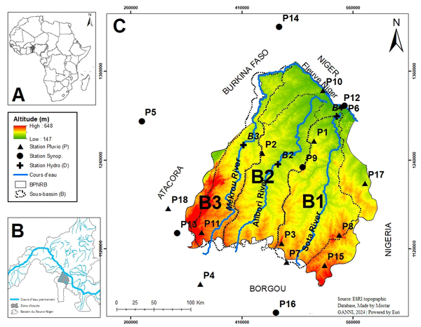
Orou Moctar Ganni Mampo, Kossi François Guedje, Ezéchiel Obada, Halissou Yarou, Bruno Merz, Ravi Kumar Guntu, Jean Hounkpe, and Adéchina Eric Alamou
Proc. IAHS, 388, 33–41, https://doi.org/10.5194/piahs-388-33-2026, https://doi.org/10.5194/piahs-388-33-2026, 2026
Short summary
Short summary
This study explored how droughts have evolved over time in northern Benin, a region that relies heavily on rainfall for farming. By analyzing rainfall and river flow patterns, the research found that while conditions improved after major droughts in the 1970s and 1980s, recent years have seen longer dry spells and worsening water shortages. These results can inform better planning for farming and water use in a changing climate.
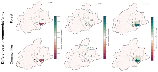
Ileen N. Streefkerk, Jeroen C. J. H. Aerts, Jens de Bruijn, Khalid Hassaballah, Rhoda Achieng' Odongo, Teun Schrieks, Oliver Wasonga, and Anne F. Van Loon
Hydrol. Earth Syst. Sci., 30, 2225–2245, https://doi.org/10.5194/hess-30-2225-2026, https://doi.org/10.5194/hess-30-2225-2026, 2026
Short summary
Short summary
In East Africa are conflict over water and vegetation prominent. On top of that, water abstraction of commercial farms are increasing the competition of water. Therefore, this study has developed a model which can investigate what the influence is of these farming activities on the water balance of the region and people's livelihood activities in times of dry periods. We do that by ‘replacing’ the farms in the model, and see what the effect would be if there were communities or forests instead.
Tim Busker, Daniela Rodriguez Castro, Sergiy Vorogushyn, Jaap Kwadijk, Davide Zoccatelli, Rafaella G. L. Oliveira, Heather J. Murdock, Laurent Pfister, Benjamin Dewals, Kymo Slager, Annegret H. Thieken, Jan Verkade, Patrick Willems, and Jeroen C. J. H. Aerts
Nat. Hazards Earth Syst. Sci., 26, 1457–1478, https://doi.org/10.5194/nhess-26-1457-2026, https://doi.org/10.5194/nhess-26-1457-2026, 2026
Short summary
Short summary
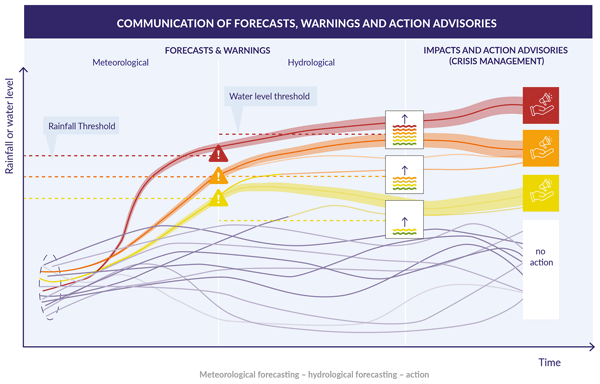
In July 2021, the Netherlands, Luxembourg, Germany, and Belgium were hit by an extreme flood event with over 200 fatalities. Our study provides, for the first time, critical insights into the operational flood early-warning systems in this entire region. Based on 14 expert interviews, we conclude that the systems strongly improved in all countries. Interviewees stressed the need for operational impact-based forecasts, but emphasized that its operational implementation is challenging.
Huazhi Li, Robert A. Jane, Dirk Eilander, Alejandra R. Enríquez, Toon Haer, and Philip J. Ward
Nat. Hazards Earth Syst. Sci., 26, 391–409, https://doi.org/10.5194/nhess-26-391-2026, https://doi.org/10.5194/nhess-26-391-2026, 2026
Short summary
Short summary
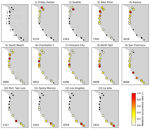
We assess the likelihood of widespread compound flooding along the U.S. coastline. Using a large set of generated plausible events preserving observed dependence, we find that nearly half of compound floods on the West coast affect multiple sites. Such events are rarer on the East coast while most compound events affect single sites on the Gulf coast. Our results underscore the importance of including spatial dependence in compound flood risk assessment and can help in better risk management.

Vylon Ooms, Thijs Endendijk, Jeroen C. J. H. Aerts, W. J. Wouter Botzen, and Peter J. Robinson
Nat. Hazards Earth Syst. Sci., 25, 4283–4298, https://doi.org/10.5194/nhess-25-4283-2025, https://doi.org/10.5194/nhess-25-4283-2025, 2025
Short summary
Short summary
Intense rainfall events cause increasingly severe damages to urban areas globally. We use unique insurance claims data to study the effect of nature-based and other adaptation measures on damage. We compare an area in Amsterdam where measures have been implemented to a similar, adjacent area without measures using an innovative method. We find a significant reduction of damage where the adaptation measures were implemented. Urban areas can reduce rain damage by implementing adaptation measures.
Julius Schlumberger, Robert Šakić Trogrlić, Jeroen C. J. H. Aerts, Jung-Hee Hyun, Stefan Hochrainer-Stigler, Marleen de Ruiter, and Marjolijn Haasnoot
Nat. Hazards Earth Syst. Sci., 25, 4089–4113, https://doi.org/10.5194/nhess-25-4089-2025, https://doi.org/10.5194/nhess-25-4089-2025, 2025
Short summary
Short summary
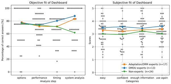
This study presents a dashboard to help decision-makers manage risks in a changing climate. Using interactive visualizations, it simplifies complex choices, even with uncertain information. Tested with 54 users of varying expertise, it enabled accurate responses to 71–80 % of questions. Users valued its scenario exploration and detailed data features. While effective, the guidance and set of visualizations could be extended and the prototype could be adapted for broader applications.
Xiaoxiang Guan, Viet Dung Nguyen, Paul Voit, Bruno Merz, Maik Heistermann, and Sergiy Vorogushyn
Nat. Hazards Earth Syst. Sci., 25, 3075–3086, https://doi.org/10.5194/nhess-25-3075-2025, https://doi.org/10.5194/nhess-25-3075-2025, 2025
Short summary
Short summary
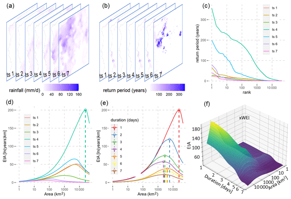
We evaluated a multi-site stochastic regional weather generator (nsRWG) for its ability to capture the cross-scale extremity of heavy-precipitation events (HPEs) in Germany. We generated 100 realizations of 72 years of daily synthetic precipitation data. The performance was assessed using WEI and xWEI indices, which measure event extremity across spatiotemporal scales. The results show that nsRWG simulates the extremity patterns of HPEs well, although it overestimates short-duration small-extent events.
Irene Benito, Jeroen C. J. H. Aerts, Philip J. Ward, Dirk Eilander, and Sanne Muis
Nat. Hazards Earth Syst. Sci., 25, 2287–2315, https://doi.org/10.5194/nhess-25-2287-2025, https://doi.org/10.5194/nhess-25-2287-2025, 2025
Short summary
Short summary
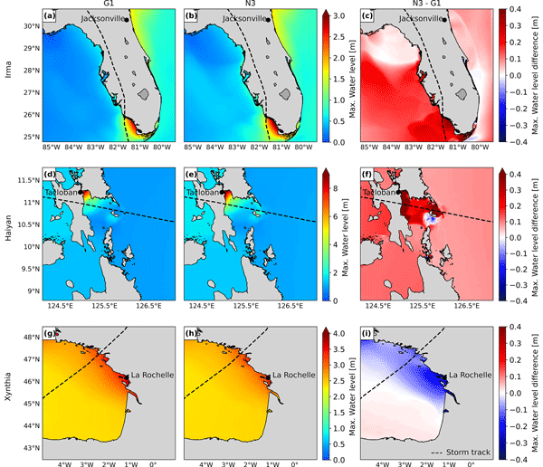
Global flood models are key to the mitigation of coastal flooding impacts, yet they still have limitations when providing actionable insights locally. We present a multiscale framework that couples dynamic water level and flood models and bridges the fully global and local modelling approaches. We apply it to three historical storms. Our findings reveal that the importance of model refinements varies based on the study area characteristics and the storm’s nature.
Sergiy Vorogushyn, Li Han, Heiko Apel, Viet Dung Nguyen, Björn Guse, Xiaoxiang Guan, Oldrich Rakovec, Husain Najafi, Luis Samaniego, and Bruno Merz
Nat. Hazards Earth Syst. Sci., 25, 2007–2029, https://doi.org/10.5194/nhess-25-2007-2025, https://doi.org/10.5194/nhess-25-2007-2025, 2025
Short summary
Short summary
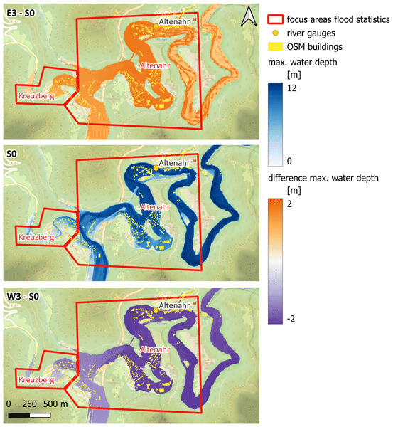
The July 2021 flood in central Europe was one of the deadliest floods in Europe in the recent decades and the most expensive flood in Germany. In this paper, we show that the hydrological impact of this event in the Ahr valley could have been even worse if the rainfall footprint trajectory had been only slightly different. The presented methodology of spatial counterfactuals generates plausible unprecedented events and helps to better prepare for future extreme floods.
Lucas Terlinden-Ruhl, Anaïs Couasnon, Dirk Eilander, Gijs G. Hendrickx, Patricia Mares-Nasarre, and José A. Á. Antolínez
Nat. Hazards Earth Syst. Sci., 25, 1353–1375, https://doi.org/10.5194/nhess-25-1353-2025, https://doi.org/10.5194/nhess-25-1353-2025, 2025
Short summary
Short summary
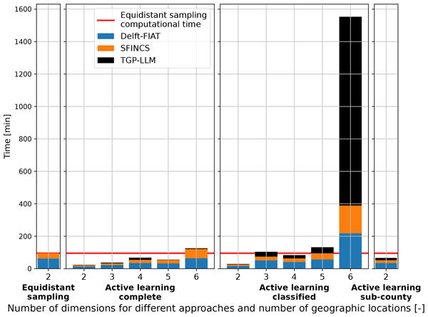
This study develops a conceptual framework that uses active learning to accelerate compound flood risk assessments. A case study of Charleston County shows that the framework achieves faster and more accurate risk quantification compared to the state-of-the-art. This win–win allows for an increase in the number of flooding parameters, which results in an 11.6 % difference in the expected annual damages. Therefore, this framework allows for more comprehensive compound flood risk assessments.
Xiaoxiang Guan, Baoying Shan, Viet Dung Nguyen, and Bruno Merz
EGUsphere, https://doi.org/10.5194/egusphere-2025-1509, https://doi.org/10.5194/egusphere-2025-1509, 2025
Preprint archived
Short summary
Short summary
Understanding and predicting extreme floods is crucial for reducing disaster risks, yet existing models struggle with unprecedented events. We tested multiple modeling approaches across 400+ river catchments in Central Europe and found that deep learning models outperform traditional methods but still underestimate extreme floods. Our findings suggest that combining data-driven models with physical knowledge can improve flood predictions, helping communities better prepare for future extremes.
Maurice W. M. L. Kalthof, Jens de Bruijn, Hans de Moel, Heidi Kreibich, and Jeroen C. J. H. Aerts
Nat. Hazards Earth Syst. Sci., 25, 1013–1035, https://doi.org/10.5194/nhess-25-1013-2025, https://doi.org/10.5194/nhess-25-1013-2025, 2025
Short summary
Short summary
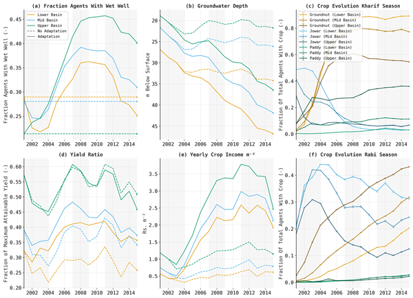
Our study explores how farmers in India's Bhima basin respond to consecutive droughts. We simulated farmers' individual choices – like changing crops or digging wells – and their effects on profits, yields, and water resources. Results show these adaptations, while improving incomes, ultimately increase drought vulnerability and damage. Such insights emphasize the need for alternative adaptations and highlight the value of socio-hydrological models in shaping policies to lessen drought impacts.
Nadja Veigel, Heidi Kreibich, Jens A. de Bruijn, Jeroen C. J. H. Aerts, and Andrea Cominola
Nat. Hazards Earth Syst. Sci., 25, 879–891, https://doi.org/10.5194/nhess-25-879-2025, https://doi.org/10.5194/nhess-25-879-2025, 2025
Short summary
Short summary
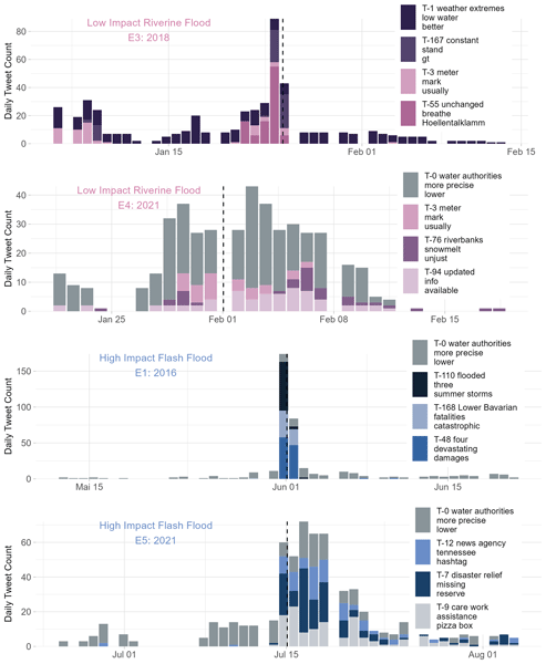
This study explores how social media, specifically Twitter (X), can help us understand public reactions to floods in Germany from 2014 to 2021. Using large language models, we extract topics and patterns of behavior from flood-related tweets. The findings offer insights to improve communication and disaster management. Topics related to low-impact flooding contain descriptive hazard-related content, while the focus shifts to catastrophic impacts and responsibilities during high-impact events.
Joshua Green, Ivan D. Haigh, Niall Quinn, Jeff Neal, Thomas Wahl, Melissa Wood, Dirk Eilander, Marleen de Ruiter, Philip Ward, and Paula Camus
Nat. Hazards Earth Syst. Sci., 25, 747–816, https://doi.org/10.5194/nhess-25-747-2025, https://doi.org/10.5194/nhess-25-747-2025, 2025
Short summary
Short summary
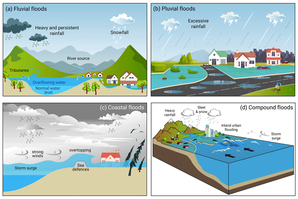
Compound flooding, involving the combination or successive occurrence of two or more flood drivers, can amplify flood impacts in coastal/estuarine regions. This paper reviews the practices, trends, methodologies, applications, and findings of coastal compound flooding literature at regional to global scales. We explore the types of compound flood events, their mechanistic processes, and the range of terminology. Lastly, this review highlights knowledge gaps and implications for future practices.
Elena Macdonald, Bruno Merz, Viet Dung Nguyen, and Sergiy Vorogushyn
Hydrol. Earth Syst. Sci., 29, 447–463, https://doi.org/10.5194/hess-29-447-2025, https://doi.org/10.5194/hess-29-447-2025, 2025
Short summary
Short summary
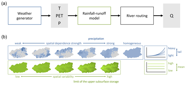
Flood peak distributions indicate how likely the occurrence of an extreme flood is at a certain river. If the distribution has a so-called heavy tail, extreme floods are more likely than might be anticipated. We find heavier tails in small catchments compared to large catchments, and spatially variable rainfall leads to a lower occurrence probability of extreme floods. Spatially variable runoff does not show effects. The results can improve estimations of probabilities of extreme floods.
Kushagra Pandey, Jens A. de Bruijn, Hans de Moel, W. J. Wouter Botzen, and Jeroen C. J. H. Aerts
Nat. Hazards Earth Syst. Sci., 24, 4409–4429, https://doi.org/10.5194/nhess-24-4409-2024, https://doi.org/10.5194/nhess-24-4409-2024, 2024
Short summary
Short summary
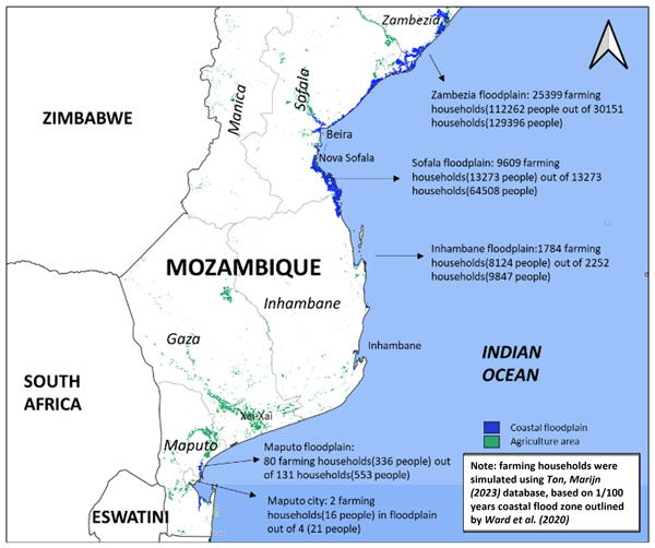
As sea levels rise, coastal areas will experience more frequent flooding, and salt water will start seeping into the soil, which is a serious issue for farmers who rely on good soil quality for their crops. Here, we studied coastal Mozambique to understand the risks from sea level rise and flooding by looking at how salt intrusion affects farming and how floods damage buildings. We find that 15 %–21 % of coastal households will adapt and 13 %–20 % will migrate to inland areas in the future.
Sadhana Nirandjan, Elco E. Koks, Mengqi Ye, Raghav Pant, Kees C. H. Van Ginkel, Jeroen C. J. H. Aerts, and Philip J. Ward
Nat. Hazards Earth Syst. Sci., 24, 4341–4368, https://doi.org/10.5194/nhess-24-4341-2024, https://doi.org/10.5194/nhess-24-4341-2024, 2024
Short summary
Short summary
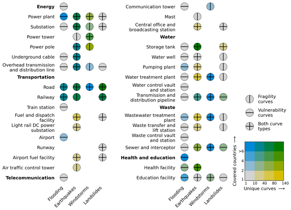
Critical infrastructures (CIs) are exposed to natural hazards, which may result in significant damage and burden society. Vulnerability is a key determinant for reducing these risks, yet crucial information is scattered in the literature. Our study reviews over 1510 fragility and vulnerability curves for CI assets, creating a unique publicly available physical vulnerability database that can be directly used for hazard risk assessments, including floods, earthquakes, windstorms, and landslides.
Bruno Merz, Günter Blöschl, Robert Jüpner, Heidi Kreibich, Kai Schröter, and Sergiy Vorogushyn
Nat. Hazards Earth Syst. Sci., 24, 4015–4030, https://doi.org/10.5194/nhess-24-4015-2024, https://doi.org/10.5194/nhess-24-4015-2024, 2024
Short summary
Short summary
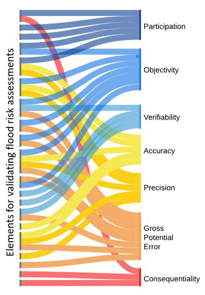
Flood risk assessments help us decide how to reduce the risk of flooding. Since these assessments are based on probabilities, it is hard to check their accuracy by comparing them to past data. We suggest a new way to validate these assessments, making sure they are practical for real-life decisions. This approach looks at both the technical details and the real-world situations where decisions are made. We demonstrate its practicality by applying it to flood emergency planning.
Viet Dung Nguyen, Sergiy Vorogushyn, Katrin Nissen, Lukas Brunner, and Bruno Merz
Adv. Stat. Clim. Meteorol. Oceanogr., 10, 195–216, https://doi.org/10.5194/ascmo-10-195-2024, https://doi.org/10.5194/ascmo-10-195-2024, 2024
Short summary
Short summary
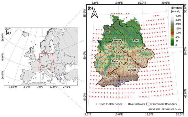
We present a novel stochastic weather generator conditioned on circulation patterns and regional temperature, accounting for dynamic and thermodynamic atmospheric changes. We extensively evaluate the model for the central European region. It statistically downscales precipitation for future periods, generating long, spatially and temporally consistent series. Results suggest an increase in extreme precipitation over the region, offering key benefits for hydrological impact studies.
Viet Dung Nguyen, Jeroen Aerts, Max Tesselaar, Wouter Botzen, Heidi Kreibich, Lorenzo Alfieri, and Bruno Merz
Nat. Hazards Earth Syst. Sci., 24, 2923–2937, https://doi.org/10.5194/nhess-24-2923-2024, https://doi.org/10.5194/nhess-24-2923-2024, 2024
Short summary
Short summary
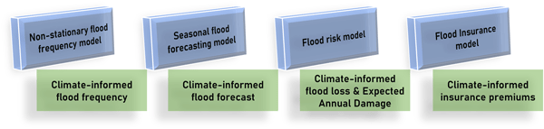
Our study explored how seasonal flood forecasts could enhance insurance premium accuracy. Insurers traditionally rely on historical data, yet climate fluctuations influence flood risk. We employed a method that predicts seasonal floods to adjust premiums accordingly. Our findings showed significant year-to-year variations in flood risk and premiums, underscoring the importance of adaptability. Despite limitations, this research aids insurers in preparing for evolving risks.
Alberto Montanari, Bruno Merz, and Günter Blöschl
Hydrol. Earth Syst. Sci., 28, 2603–2615, https://doi.org/10.5194/hess-28-2603-2024, https://doi.org/10.5194/hess-28-2603-2024, 2024
Short summary
Short summary
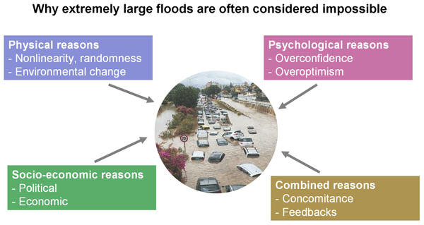
Floods often take communities by surprise, as they are often considered virtually
impossibleyet are an ever-present threat similar to the sword suspended over the head of Damocles in the classical Greek anecdote. We discuss four reasons why extremely large floods carry a risk that is often larger than expected. We provide suggestions for managing the risk of megafloods by calling for a creative exploration of hazard scenarios and communicating the unknown corners of the reality of floods.
Willem J. van Verseveld, Albrecht H. Weerts, Martijn Visser, Joost Buitink, Ruben O. Imhoff, Hélène Boisgontier, Laurène Bouaziz, Dirk Eilander, Mark Hegnauer, Corine ten Velden, and Bobby Russell
Geosci. Model Dev., 17, 3199–3234, https://doi.org/10.5194/gmd-17-3199-2024, https://doi.org/10.5194/gmd-17-3199-2024, 2024
Short summary
Short summary
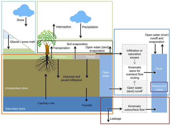
We present the wflow_sbm distributed hydrological model, recently released by Deltares, as part of the Wflow.jl open-source modelling framework in the programming language Julia. Wflow_sbm has a fast runtime, making it suitable for large-scale modelling. Wflow_sbm models can be set a priori for any catchment with the Python tool HydroMT-Wflow based on globally available datasets, which results in satisfactory to good performance (without much tuning). We show this for a number of specific cases.
Eric Mortensen, Timothy Tiggeloven, Toon Haer, Bas van Bemmel, Dewi Le Bars, Sanne Muis, Dirk Eilander, Frederiek Sperna Weiland, Arno Bouwman, Willem Ligtvoet, and Philip J. Ward
Nat. Hazards Earth Syst. Sci., 24, 1381–1400, https://doi.org/10.5194/nhess-24-1381-2024, https://doi.org/10.5194/nhess-24-1381-2024, 2024
Short summary
Short summary
Current levels of coastal flood risk are projected to increase in coming decades due to various reasons, e.g. sea-level rise, land subsidence, and coastal urbanization: action is needed to minimize this future risk. We evaluate dykes and coastal levees, foreshore vegetation, zoning restrictions, and dry-proofing on a global scale to estimate what levels of risk reductions are possible. We demonstrate that there are several potential adaptation pathways forward for certain areas of the world.
Seth Bryant, Heidi Kreibich, and Bruno Merz
Proc. IAHS, 386, 181–187, https://doi.org/10.5194/piahs-386-181-2024, https://doi.org/10.5194/piahs-386-181-2024, 2024
Short summary
Short summary
Our study found that simplifying data in flood risk models can introduce errors. We tested 344 damage functions and found errors up to 40 % of the total asset value. This means large-scale flood risk assessments may have significant errors due to the modelling approach. Our research highlights the need for more attention to data aggregation in flood risk models.
Elena Macdonald, Bruno Merz, Björn Guse, Viet Dung Nguyen, Xiaoxiang Guan, and Sergiy Vorogushyn
Hydrol. Earth Syst. Sci., 28, 833–850, https://doi.org/10.5194/hess-28-833-2024, https://doi.org/10.5194/hess-28-833-2024, 2024
Short summary
Short summary
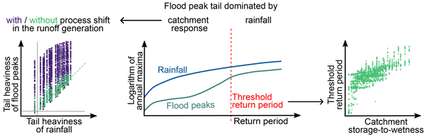
In some rivers, the occurrence of extreme flood events is more likely than in other rivers – they have heavy-tailed distributions. We find that threshold processes in the runoff generation lead to such a relatively high occurrence probability of extremes. Further, we find that beyond a certain return period, i.e. for rare events, rainfall is often the dominant control compared to runoff generation. Our results can help to improve the estimation of the occurrence probability of extreme floods.
Seth Bryant, Guy Schumann, Heiko Apel, Heidi Kreibich, and Bruno Merz
Hydrol. Earth Syst. Sci., 28, 575–588, https://doi.org/10.5194/hess-28-575-2024, https://doi.org/10.5194/hess-28-575-2024, 2024
Short summary
Short summary
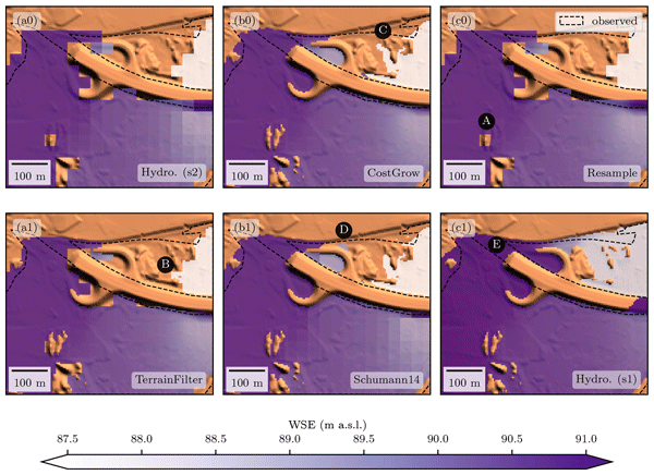
A new algorithm has been developed to quickly produce high-resolution flood maps. It is faster and more accurate than current methods and is available as open-source scripts. This can help communities better prepare for and mitigate flood damages without expensive modelling.
Rhoda A. Odongo, Hans De Moel, and Anne F. Van Loon
Nat. Hazards Earth Syst. Sci., 23, 2365–2386, https://doi.org/10.5194/nhess-23-2365-2023, https://doi.org/10.5194/nhess-23-2365-2023, 2023
Short summary
Short summary
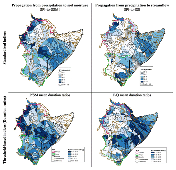
We characterize meteorological (P), soil moisture (SM) and hydrological (Q) droughts and the propagation from one to the other for 318 catchments in the Horn of Africa. We find that propagation from P to SM is influenced by soil properties and vegetation, while propagation from P to Q is from catchment-scale hydrogeological properties (i.e. geology, slope). We provide precipitation accumulation periods at the subbasin level that can be used as a proxy in drought forecasting in dryland regions.
Dirk Eilander, Anaïs Couasnon, Frederiek C. Sperna Weiland, Willem Ligtvoet, Arno Bouwman, Hessel C. Winsemius, and Philip J. Ward
Nat. Hazards Earth Syst. Sci., 23, 2251–2272, https://doi.org/10.5194/nhess-23-2251-2023, https://doi.org/10.5194/nhess-23-2251-2023, 2023
Short summary
Short summary
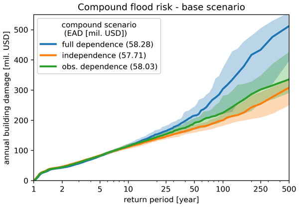
This study presents a framework for assessing compound flood risk using hydrodynamic, impact, and statistical modeling. A pilot in Mozambique shows the importance of accounting for compound events in risk assessments. We also show how the framework can be used to assess the effectiveness of different risk reduction measures. As the framework is based on global datasets and is largely automated, it can easily be applied in other areas for first-order assessments of compound flood risk.
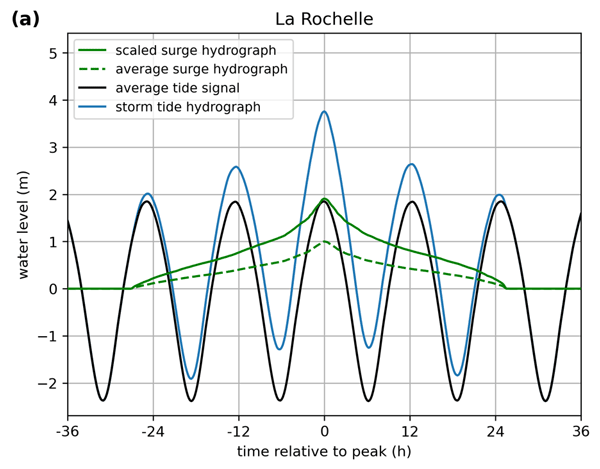
Job C. M. Dullaart, Sanne Muis, Hans de Moel, Philip J. Ward, Dirk Eilander, and Jeroen C. J. H. Aerts
Nat. Hazards Earth Syst. Sci., 23, 1847–1862, https://doi.org/10.5194/nhess-23-1847-2023, https://doi.org/10.5194/nhess-23-1847-2023, 2023
Short summary
Short summary
Coastal flooding is driven by storm surges and high tides and can be devastating. To gain an understanding of the threat posed by coastal flooding and to identify areas that are especially at risk, now and in the future, it is crucial to accurately model coastal inundation and assess the coastal flood hazard. Here, we present a global dataset with hydrographs that represent the typical evolution of an extreme sea level. These can be used to model coastal inundation more accurately.
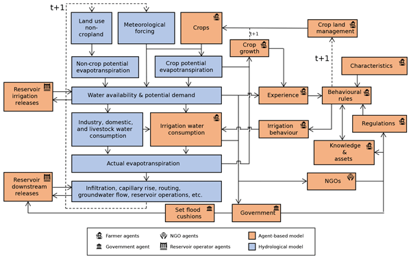
Jens A. de Bruijn, Mikhail Smilovic, Peter Burek, Luca Guillaumot, Yoshihide Wada, and Jeroen C. J. H. Aerts
Geosci. Model Dev., 16, 2437–2454, https://doi.org/10.5194/gmd-16-2437-2023, https://doi.org/10.5194/gmd-16-2437-2023, 2023
Short summary
Short summary
We present a computer simulation model of the hydrological system and human system, which can simulate the behaviour of individual farmers and their interactions with the water system at basin scale to assess how the systems have evolved and are projected to evolve in the future. For example, we can simulate the effect of subsidies provided on investment in adaptation measures and subsequent effects in the hydrological system, such as a lowering of the groundwater table or reservoir level.
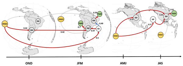
Raed Hamed, Sem Vijverberg, Anne F. Van Loon, Jeroen Aerts, and Dim Coumou
Earth Syst. Dynam., 14, 255–272, https://doi.org/10.5194/esd-14-255-2023, https://doi.org/10.5194/esd-14-255-2023, 2023
Short summary
Short summary
Spatially compounding soy harvest failures can have important global impacts. Using causal networks, we show that soy yields are predominately driven by summer soil moisture conditions in North and South America. Summer soil moisture is affected by antecedent soil moisture and by remote extra-tropical SST patterns in both hemispheres. Both of these soil moisture drivers are again influenced by ENSO. Our results highlight physical pathways by which ENSO can drive spatially compounding impacts.
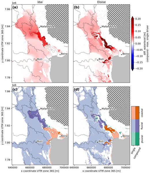
Dirk Eilander, Anaïs Couasnon, Tim Leijnse, Hiroaki Ikeuchi, Dai Yamazaki, Sanne Muis, Job Dullaart, Arjen Haag, Hessel C. Winsemius, and Philip J. Ward
Nat. Hazards Earth Syst. Sci., 23, 823–846, https://doi.org/10.5194/nhess-23-823-2023, https://doi.org/10.5194/nhess-23-823-2023, 2023
Short summary
Short summary
In coastal deltas, flooding can occur from interactions between coastal, riverine, and pluvial drivers, so-called compound flooding. Global models however ignore these interactions. We present a framework for automated and reproducible compound flood modeling anywhere globally and validate it for two historical events in Mozambique with good results. The analysis reveals differences in compound flood dynamics between both events related to the magnitude of and time lag between drivers.
Paolo Scussolini, Job Dullaart, Sanne Muis, Alessio Rovere, Pepijn Bakker, Dim Coumou, Hans Renssen, Philip J. Ward, and Jeroen C. J. H. Aerts
Clim. Past, 19, 141–157, https://doi.org/10.5194/cp-19-141-2023, https://doi.org/10.5194/cp-19-141-2023, 2023
Short summary
Short summary
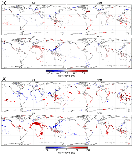
We reconstruct sea level extremes due to storm surges in a past warmer climate. We employ a novel combination of paleoclimate modeling and global ocean hydrodynamic modeling. We find that during the Last Interglacial, about 127 000 years ago, seasonal sea level extremes were indeed significantly different – higher or lower – on long stretches of the global coast. These changes are associated with different patterns of atmospheric storminess linked with meridional shifts in wind bands.
Heiko Apel, Sergiy Vorogushyn, and Bruno Merz
Nat. Hazards Earth Syst. Sci., 22, 3005–3014, https://doi.org/10.5194/nhess-22-3005-2022, https://doi.org/10.5194/nhess-22-3005-2022, 2022
Short summary
Short summary
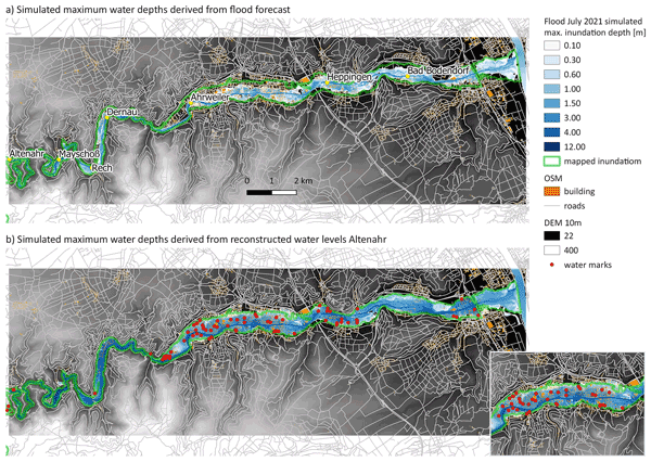
The paper presents a fast 2D hydraulic simulation model for flood propagation that enables operational forecasts of spatially distributed inundation depths, flood extent, flow velocities, and other flood impacts. The detailed spatial forecast of floods and flood impacts is a large step forward from the currently operational forecasts of discharges at selected gauges, thus enabling a more targeted flood management and early warning.
Philip J. Ward, James Daniell, Melanie Duncan, Anna Dunne, Cédric Hananel, Stefan Hochrainer-Stigler, Annegien Tijssen, Silvia Torresan, Roxana Ciurean, Joel C. Gill, Jana Sillmann, Anaïs Couasnon, Elco Koks, Noemi Padrón-Fumero, Sharon Tatman, Marianne Tronstad Lund, Adewole Adesiyun, Jeroen C. J. H. Aerts, Alexander Alabaster, Bernard Bulder, Carlos Campillo Torres, Andrea Critto, Raúl Hernández-Martín, Marta Machado, Jaroslav Mysiak, Rene Orth, Irene Palomino Antolín, Eva-Cristina Petrescu, Markus Reichstein, Timothy Tiggeloven, Anne F. Van Loon, Hung Vuong Pham, and Marleen C. de Ruiter
Nat. Hazards Earth Syst. Sci., 22, 1487–1497, https://doi.org/10.5194/nhess-22-1487-2022, https://doi.org/10.5194/nhess-22-1487-2022, 2022
Short summary
Short summary
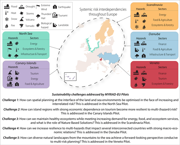
The majority of natural-hazard risk research focuses on single hazards (a flood, a drought, a volcanic eruption, an earthquake, etc.). In the international research and policy community it is recognised that risk management could benefit from a more systemic approach. In this perspective paper, we argue for an approach that addresses multi-hazard, multi-risk management through the lens of sustainability challenges that cut across sectors, regions, and hazards.
Marthe L. K. Wens, Anne F. van Loon, Ted I. E. Veldkamp, and Jeroen C. J. H. Aerts
Nat. Hazards Earth Syst. Sci., 22, 1201–1232, https://doi.org/10.5194/nhess-22-1201-2022, https://doi.org/10.5194/nhess-22-1201-2022, 2022
Short summary
Short summary
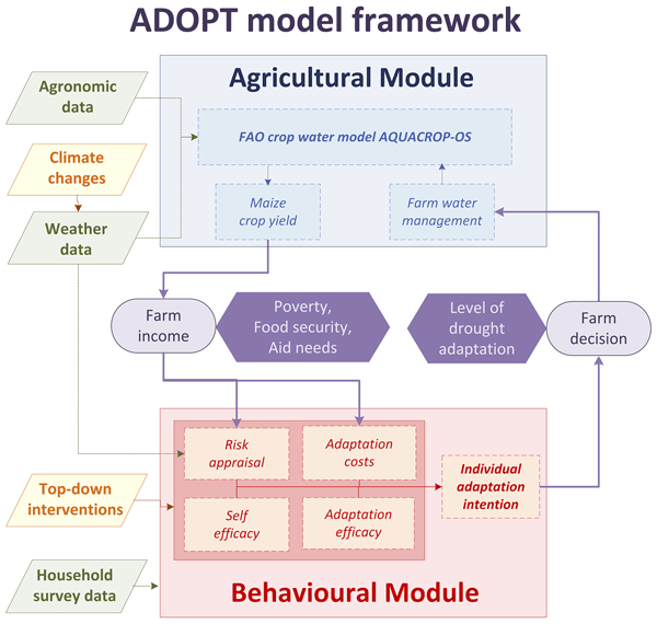
In this paper, we present an application of the empirically calibrated drought risk adaptation model ADOPT for the case of smallholder farmers in the Kenyan drylands. ADOPT is used to evaluate the effect of various top-down drought risk reduction interventions (extension services, early warning systems, ex ante cash transfers, and low credit rates) on individual and community drought risk (adaptation levels, food insecurity, poverty, emergency aid) under different climate change scenarios.
Raed Hamed, Anne F. Van Loon, Jeroen Aerts, and Dim Coumou
Earth Syst. Dynam., 12, 1371–1391, https://doi.org/10.5194/esd-12-1371-2021, https://doi.org/10.5194/esd-12-1371-2021, 2021
Short summary
Short summary
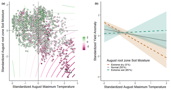
Soy yields in the US are affected by climate variability. We identify the main within-season climate drivers and highlight potential compound events and associated agricultural impacts. Our results show that soy yields are most negatively influenced by the combination of high temperature and low soil moisture during the summer crop reproductive period. Furthermore, we highlight the role of temperature and moisture coupling across the year in generating these hot–dry extremes and linked impacts.
Lucas Wouters, Anaïs Couasnon, Marleen C. de Ruiter, Marc J. C. van den Homberg, Aklilu Teklesadik, and Hans de Moel
Nat. Hazards Earth Syst. Sci., 21, 3199–3218, https://doi.org/10.5194/nhess-21-3199-2021, https://doi.org/10.5194/nhess-21-3199-2021, 2021
Short summary
Short summary
This research introduces a novel approach to estimate flood damage in Malawi by applying a machine learning model to UAV imagery. We think that the development of such a model is an essential step to enable the swift allocation of resources for recovery by humanitarian decision-makers. By comparing this method (EUR 10 140) to a conventional land-use-based approach (EUR 15 782) for a specific flood event, recommendations are made for future assessments.
Cited articles
Abrams, M., Crippen, R., and Fujisada, H.: ASTER Global Digital Elevation Model (GDEM) and ASTER Global Water Body Dataset (ASTWBD), Remote Sens.-Basel, 12, 1156, https://doi.org/10.3390/rs12071156, 2020.
Alfieri, L., Burek, P., Dutra, E., Krzeminski, B., Muraro, D., Thielen, J., and Pappenberger, F.: GloFAS – global ensemble streamflow forecasting and flood early warning, Hydrol. Earth Syst. Sci., 17, 1161–1175, https://doi.org/10.5194/hess-17-1161-2013, 2013.
Allen, G. H. and Pavelsky, T. M.: Global River Widths from Landsat (GRWL) Database, Zenodo [data set], https://doi.org/10.5281/zenodo.1297434, 2018.
Altenau, E. H., Pavelsky, T. M., Durand, M. T., Yang, X., De Moraes Frasson, R. P., and Bendezu, L.: The Surface Water and Ocean Topography (SWOT) Mission River Database (SWORD): a global river network for satellite data products, Water Resour. Res., 57, e2021WR030054, https://doi.org/10.1029/2021WR030054, 2021.
Andreadis, K. M., Schumann, G. J., and Pavelsky, T.: A simple global river bankfull width and depth database, Water Resour. Res., 49, 7164–7168, https://doi.org/10.1002/wrcr.20440, 2013.
Apel, H., Benisch, J., Helm, B., Vorogushyn, S., and Merz, B.: Fast urban inundation simulation with RIM2D for flood risk assessment and forecasting, Front. Water, 6, 1310182, https://doi.org/10.3389/frwa.2024.1310182, 2024.
Bates, P.: Fundamental limits to flood inundation modelling, Nat. Water, 1, 566–567, https://doi.org/10.1038/s44221-023-00106-4, 2023.
Bates, P. D., Horritt, M. S., and Fewtrell, T. J.: A simple inertial formulation of the shallow water equations for efficient two-dimensional flood inundation modelling, J. Hydrol., 387, 33–45, https://doi.org/10.1016/j.jhydrol.2010.03.027, 2010.
Baugh, C., Colonese, J., D'Angelo, C., Dottori, F., Neal, J., Prudhomme, C., and Salamon, P.: Global river flood hazard maps, European Commission, Joint Res. Centre [data set], https://doi.org/10.2905/JRC.VD32YWG, 2024.
Beck, H. E., Zimmermann, N. E., McVicar, T. R., Vergopolan, N., Berg, A., and Wood, E. F.: Present and future Köppen-Geiger climate classification maps at 1-km resolution, Sci. Data, 5, 180214, https://doi.org/10.1038/sdata.2018.214, 2018.
Benito, I., Aerts, J. C. J. H., Eilander, D., Ward, P. J., and Muis, S.: Stochastic coastal flood risk modelling for the east coast of Africa, npj Nat. Hazards, 1, 10, https://doi.org/10.1038/s44304-024-00010-1, 2024.
Bernhofen, M. V., Whyman, C., Trigg, M. A., Sleigh, P. A., Smith, A. M., Sampson, C. C., Yamazaki, D., Ward, P. J., Rudari, R., Pappenberger, F., Dottori, F., Salamon, P., and Winsemius, H. C.: A first collective validation of global fluvial flood models for major floods in Nigeria and Mozambique, Environ. Res. Lett., 13, 104007, https://doi.org/10.1088/1748-9326/aae014, 2018.
Bril, V. C., De Bruijn, J., De Moel, H., Sadana, T., Busker, T., Botzen, W. J. W., and Aerts, J. C. J. H.: Assessing the effectiveness of nature-based solutions and building-level flood risk reduction measures: an open-source coupled model, Water Resour. Res., 62, e2025WR041436, https://doi.org/10.1029/2025WR041436, 2026.
Burek, P., Satoh, Y., Kahil, T., Tang, T., Greve, P., Smilovic, M., Guillaumot, L., Zhao, F., and Wada, Y.: Development of the Community Water Model (CWatM v1.04) – a high-resolution hydrological model for global and regional assessment of integrated water resources management, Geosci. Model Dev., 13, 3267–3298, https://doi.org/10.5194/gmd-13-3267-2020, 2020.
Cloud to Street, Microsoft, and Radiant Earth Foundation: Global Flood Database v1 (2000–2018), Google Earth Engine [data set], https://developers.google.com/earth-engine/datasets/catalog/GLOBAL_FLOOD_DB_MODIS_EVENTS_V1 (last access: 30 July 2026), 2022.
Copernicus DEM: Copernicus Global Digital Elevation Model, ESA [data set], https://doi.org/10.5270/esa-c5d3d65, 2022.
de Bruijn, J. A., Smilovic, M., Burek, P., Guillaumot, L., Wada, Y., and Aerts, J. C. J. H.: GEB v0.1: a large-scale agent-based socio-hydrological model – simulating 10 million individual farming households in a fully distributed hydrological model, Geosci. Model Dev., 16, 2437–2454, https://doi.org/10.5194/gmd-16-2437-2023, 2023.
Deltares: D-Flow Flexible Mesh: Computational Cores and User Interface, User Manual, Deltares, https://www.deltares.nl/en/software/delft3d-flexible-mesh-suite/ (last access: 16 January 2025), 2022.
Dey, S., Saksena, S., and Merwade, V.: Assessing the effect of different bathymetric models on hydraulic simulation of rivers in data sparse regions, J. Hydrol., 575, 838–851, https://doi.org/10.1016/j.jhydrol.2019.05.085, 2019.
Dey, S., Saksena, S., Winter, D., Merwade, V., and McMillan, S.: Incorporating network scale river bathymetry to improve characterization of fluvial processes in flood modeling, Water Resour. Res., 58, e2020WR029521, https://doi.org/10.1029/2020WR029521, 2022.
Dottori, F., Salamon, P., Bianchi, A., Alfieri, L., Hirpa, F. A., and Feyen, L.: Development and evaluation of a framework for global flood hazard mapping, Adv. Water Resour., 94, 87–102, https://doi.org/10.1016/j.advwatres.2016.05.002, 2016.
Dottori, F., Alfieri, L., Bianchi, A., Skoien, J., and Salamon, P.: A new dataset of river flood hazard maps for Europe and the Mediterranean Basin, Earth Syst. Sci. Data, 14, 1549–1569, https://doi.org/10.5194/essd-14-1549-2022, 2022.
Edwards, P. J., Watson, E. A., and Wood, F.: Toward a better understanding of recurrence intervals, bankfull, and their importance, J. Contemp. Water Res. Educ., https://doi.org/10.1111/j.1936-704X.2019.03300.x, 2019.
Eilander, D., Boisgontier, H., Bouaziz, L. J. E., Buitink, J., Couasnon, A., Dalmijn, B., Hegnauer, M., De Jong, T., Loos, S., Marth, I., and Van Verseveld, W.: HydroMT: automated and reproducible model building and analysis, J. Open Source Softw., 8, 4897, https://doi.org/10.21105/joss.04897, 2023a.
Eilander, D., Couasnon, A., Leijnse, T., Ikeuchi, H., Yamazaki, D., Muis, S., Dullaart, J., Haag, A., Winsemius, H. C., and Ward, P. J.: A globally applicable framework for compound flood hazard modeling, Nat. Hazards Earth Syst. Sci., 23, 823–846, https://doi.org/10.5194/nhess-23-823-2023, 2023b.
Fleischmann, A., Collischonn, W., Paiva, R., and Tucci, C. E.: Modeling the role of reservoirs versus floodplains on large-scale river hydrodynamics, Nat. Hazards, 99, 1075–1104, https://doi.org/10.1007/s11069-019-03797-9, 2019.
Grimaldi, S., Schumann, G. J.-P., Shokri, A., Walker, J. P., and Pauwels, V. R. N.: Challenges, opportunities, and pitfalls for global coupled hydrologic-hydraulic modeling of floods, Water Resour. Res., 55, https://doi.org/10.1029/2018WR024289, 2019.
Grimaldi, S., Salamon, P., Disperati, J., Zsoter, E., Russo, C., Ramos, A., Carton De Wiart, C., Barnard, C., Hansford, E., Gomes, G., and Prudhomme, C.: GloFAS v4.0 hydrological reanalysis, European Commission, Joint Research Centre, JRC131349, https://publications.jrc.ec.europa.eu/repository/handle/JRC131349 (last access: 30 July 2026), 2022.
Guo, K., Guan, M., and Yu, D.: Urban surface water flood modelling – a comprehensive review of current models and future challenges, Hydrol. Earth Syst. Sci., 25, 2843–2860, https://doi.org/10.5194/hess-25-2843-2021, 2021.
Hall, C. A., Saia, S. M., Popp, A. L., Dogulu, N., Schymanski, S. J., Drost, N., van Emmerik, T., and Hut, R.: A hydrologist's guide to open science, Hydrol. Earth Syst. Sci., 26, 647–664, https://doi.org/10.5194/hess-26-647-2022, 2022.
Harrigan, S., Zsoter, E., Alfieri, L., Prudhomme, C., Salamon, P., Wetterhall, F., Barnard, C., Cloke, H., and Pappenberger, F.: GloFAS-ERA5 operational global river discharge reanalysis 1979–present, Earth Syst. Sci. Data, 12, 2043–2060, https://doi.org/10.5194/essd-12-2043-2020, 2020.
Hawker, L., Rougier, J., Neal, J. C., Bates, P. D., Archer, L., and Yamazaki, D.: Implications of simulating global digital elevation models for flood inundation studies, Water Resour. Res., 54, 7910–7928, https://doi.org/10.1029/2018WR023279, 2018.
Hawker, L., Uhe, P., Paulo, L., Sosa, J., Savage, J., Sampson, C., and Neal, J.: A 30 m global map of elevation with forests and buildings removed, Environ. Res. Lett., 17, 024016, https://doi.org/10.1088/1748-9326/ac4d4f, 2022.
Hawker, L., Neal, J., Savage, J., Kirkpatrick, T., Lord, R., Zylberberg, Y., Groeger, A., Thuy, T. D., Fox, S., Agyemang, F., and Nam, P. K.: Assessing LISFLOOD-FP with the next-generation digital elevation model FABDEM using household survey and remote sensing data in the Central Highlands of Vietnam, Nat. Hazards Earth Syst. Sci., 24, 539–566, https://doi.org/10.5194/nhess-24-539-2024, 2024.
Hoch, J. M. and Trigg, M. A.: Advancing global flood hazard simulations by improving comparability, benchmarking, and integration of global flood models, Environ. Res. Lett., 14, 034001, https://doi.org/10.1088/1748-9326/aaf3d3, 2019.
Jiang, W., Yu, J., Wang, Q., and Yue, Q.: Understanding the effects of digital elevation model resolution and building treatment for urban flood modelling, J. Hydrol. Reg. Stud., 44, 101122, https://doi.org/10.1016/j.ejrh.2022.101122, 2022.
Kim, D. E., Gourbesville, P., and Liong, S. Y.: Overcoming data scarcity in flood hazard assessment using remote sensing and artificial neural network, Smart Water, 4, 2, https://doi.org/10.1186/s40713-018-0014-5, 2019.
Landwehr, T., Dasgupta, A., and Waske, B.: Towards robust validation strategies for EO flood maps, Remote Sens. Environ., 315, 114439, https://doi.org/10.1016/j.rse.2024.114439, 2024.
Larnier, K., Monnier, J., Garambois, P. A., and Verley, J.: River discharge and bathymetry estimation from SWOT altimetry measurements, Inverse Probl. Sci. En., 29, 759–789, https://doi.org/10.1080/17415977.2020.1803858, 2020.
Leijnse, T., Van Ormondt, M., Nederhoff, K., and Van Dongeren, A.: Modeling compound flooding in coastal systems using a computationally efficient reduced-physics solver: including fluvial, pluvial, tidal, wind- and wave-driven processes, Coast. Eng., 163, 103796, https://doi.org/10.1016/j.coastaleng.2020.103796, 2021.
Leopold, L. B. and Maddock, T.: The hydraulic geometry of stream channels and some physiographic implications, Professional Paper 252, U. S. Geol. Surv., Washington, D. C., 57 pp., https://doi.org/10.3133/pp252, 1953.
Lin, P., Pan, M., Beck, H. E., Yang, Y., Yamazaki, D., Frasson, R., David, C. H., Durand, M., Pavelsky, T. M., Allen, G. H., Gleason, C. J., and Wood, E. F.: Global reconstruction of naturalized river flows at 2.94 million reaches, Water Resour. Res., 55, 6499–6516, https://doi.org/10.1029/2019WR025287, 2019.
Masafu, C. and Williams, R.: Satellite video remote sensing for flood model validation, Water Resour. Res., 60, e2023WR034545, https://doi.org/10.1029/2023WR034545, 2024.
Merz, B., Blöschl, G., Vorogushyn, S., Dottori, F., Aerts, J. C. J. H., Bates, P., Bertola, M., Kemter, M., Kreibich, H., Lall, U., and Macdonald, E.: Causes, impacts and changes of extreme river floods, Nat. Rev. Earth Environ., 2, 592–609, https://doi.org/10.1038/s43017-021-00195-3, 2021.
Mester, B., Willner, S. N., Frieler, K., and Schewe, J.: Evaluation of river flood extent simulated with multiple global hydrological models and climate forcings, Environ. Res. Lett., 16, 094010, https://doi.org/10.1088/1748-9326/ac188d, 2021.
Mölder, F., Jablonski, K. P., Letcher, B., Hall, M. B., Tomkins-Tinch, C. H., Sochat, V., Forster, J., Lee, S., Twardziok, S. O., Kanitz, A., Wilm, A., Holtgrewe, M., Nahnsen, S., and Köster, J.: Sustainable data analysis with Snakemake, Zenodo [code], https://doi.org/10.5281/zenodo.4063463, 2020.
National Weather Service: Winter storm summary for January 5, 2005 to January 6, 2005 event, https://www.weather.gov/phi/01052005wss (last access: 16 January 2025), 2005a.
National Weather Service: January 5–6, 2005 Ice Storm and Flooding, https://www.weather.gov/iln/20050105 (last access: 16 January 2025), 2005b.
Neal, J., Schumann, G., and Bates, P.: A subgrid channel model for simulating river hydraulics and floodplain inundation over large and data sparse areas, Water Resour. Res., 48, W11506, https://doi.org/10.1029/2012WR012514, 2012.
Neal, J., Hawker, L., Savage, J., Durand, M., Bates, P., and Sampson, C.: Estimating river channel bathymetry in large scale flood inundation models, Water Resour. Res., 57, e2020WR028301, https://doi.org/10.1029/2020WR028301, 2021.
Nederhoff, K., Crosby, S. C., Van Arendonk, N. R., Grossman, E. E., Tehranirad, B., Leijnse, T., Klessens, W., and Barnard, P. L.: Dynamic modeling of coastal compound flooding hazards due to tides, extratropical storms, waves, and sea-level rise: a case study in the Salish Sea, Washington (USA), Water-Sui., 16, 346, https://doi.org/10.3390/w16020346, 2024.
Nevo, S., Morin, E., Gerzi Rosenthal, A., Metzger, A., Barshai, C., Weitzner, D., Voloshin, D., Kratzert, F., Elidan, G., Dror, G., Begelman, G., Nearing, G., Shalev, G., Noga, H., Shavitt, I., Yuklea, L., Royz, M., Giladi, N., Peled Levi, N., Reich, O., Gilon, O., Maor, R., Timnat, S., Shechter, T., Anisimov, V., Gigi, Y., Levin, Y., Moshe, Z., Ben-Haim, Z., Hassidim, A., and Matias, Y.: Flood forecasting with machine learning models in an operational framework, Hydrol. Earth Syst. Sci., 26, 4013–4032, https://doi.org/10.5194/hess-26-4013-2022, 2022.
Pekel, J.-F., Cottam, A., Gorelick, N., and Belward, A. S.: High-resolution mapping of global surface water and its long-term changes, Nature, 540, 418–422, https://doi.org/10.1038/nature20584, 2016.
Rad, A. M., Johnson, J. M., Ghahremani, Z., Coll, J., and Frazier, N.: Enhancing river channel dimension estimation: a machine learning approach leveraging the national water model, hydrographic networks, and landscape characteristics, J. Geophys. Res.-Mach. Learn. Comput., 1, e2024JH000173, https://doi.org/10.1029/2024JH000173, 2024.
Reshma, R., Devi, N. N., and Kuiry, S. N.: Real-time urban flood modeling: exploring the sub-grid approach for accurate simulation and hazard analysis, Nat. Hazards, 120, 9609–9647, https://doi.org/10.1007/s11069-024-06579-0, 2024.
Risling, A., Lindersson, S., and Brandimarte, L.: A comparison of global flood models using Sentinel-1 and a change detection approach, Nat. Hazards, 120, 11133–11152, https://doi.org/10.1007/s11069-024-06629-7, 2024.
Roy, N. G. and Sinha, R.: Linking hydrology and sediment dynamics of large alluvial rivers to landscape diversity in the Ganga dispersal system, India, Earth Surf. Proc. Land., 42, 1078–1091, https://doi.org/10.1002/esp.4074, 2016.
Sadana, T.: Validation of the Open-Source Hydrodynamic Model SFINCS on Historical River Floods at the Global Scale (Version 1.0), Zenodo [data set], https://doi.org/10.5281/zenodo.16759100, 2025.
Salamon, P., McCormick, N., Reimer, C., Clarke, T., Bauer-Marschallinger, B., Wagner, W., Martinis, S., Chow, C., Böhnke, C., Matgen, P., Chini, M., Hostache, R., Molini, L., Fiori, E., and Walli, A.: The new, systematic global flood monitoring product of the Copernicus Emergency Management Service, in: 2021 IEEE International Geoscience and Remote Sensing Symposium (IGARSS), Brussels, Belgium, 11–16 July 2021, 1053–1056, https://doi.org/10.1109/IGARSS47720.2021.9554214, 2021.
Salinas, J. L., Laaha, G., Rogger, M., Parajka, J., Viglione, A., Sivapalan, M., and Blöschl, G.: Comparative assessment of predictions in ungauged basins – Part 2: Flood and low flow studies, Hydrol. Earth Syst. Sci., 17, 2637–2652, https://doi.org/10.5194/hess-17-2637-2013, 2013.
Sampson, C., Smith, A., Bates, P., Neal, J., Alfieri, L., and Freer, J. E.: A high-resolution global flood hazard model, Water Resour. Res., 51, 7358–7381, https://doi.org/10.1002/2015WR016954, 2015.
Scussolini, P., Aerts, J. C. J. H., Jongman, B., Bouwer, L. M., Winsemius, H. C., de Moel, H., and Ward, P. J.: FLOPROS: an evolving global database of flood protection standards, Nat. Hazards Earth Syst. Sci., 16, 1049–1061, https://doi.org/10.5194/nhess-16-1049-2016, 2016.
Shaw, J., Kesserwani, G., Neal, J., Bates, P., and Sharifian, M. K.: LISFLOOD-FP 8.0: the new discontinuous Galerkin shallow-water solver for multi-core CPUs and GPUs, Geosci. Model Dev., 14, 3577–3602, https://doi.org/10.5194/gmd-14-3577-2021, 2021.
Smith, A., Sampson, C., and Bates, P.: Regional flood frequency analysis at the global scale, Water Resour. Res., 51, 539–553, https://doi.org/10.1002/2014WR015814, 2014.
Stephens, E., Schumann, G., and Bates, P.: Problems with binary pattern measures for flood model evaluation, Hydrol. Process., 28, 4928–4937, https://doi.org/10.1002/hyp.9979, 2014.
Tellman, B., Sullivan, J. A., Kuhn, C., Kettner, A. J., Doyle, C. S., Brakenridge, G. R., Erickson, T. A., and Slayback, D. A.: Satellite imaging reveals increased proportion of population exposed to floods, Nature, 596, 80–86, https://doi.org/10.1038/s41586-021-03695-w, 2021.
Teng, J., Jakeman, A. J., Vaze, J., Croke, B. F. W., Dutta, D., and Kim, S.: Flood inundation modelling: a review of methods, recent advances and uncertainty analysis, Environ. Modell. Softw., 90, 201–216, https://doi.org/10.1016/j.envsoft.2017.01.006, 2017.
USGS: 3D Elevation Program (3DEP) 1-meter Digital Elevation Model, U. S. Geological Survey [data set], https://www.usgs.gov/3d-elevation-program/about-3dep-products-services (last access: 16 January 2025), 2015.
USGS: What is the vertical accuracy of 3D Elevation Program (3DEP) DEMs?, U. S. Geological Survey, https://www.usgs.gov/faqs/what-vertical-accuracy-3d-elevation-program-3dep-dems (last access: 28 July 2025), 2022.
USGS: USGS current water data for the nation, U. S. Geological Survey [data set], https://waterdata.usgs.gov/nwis/rt (last access: 16 January 2025), 2023.
van Ormondt, M., Leijnse, T., de Goede, R., Nederhoff, K., and van Dongeren, A.: Subgrid corrections for the linear inertial equations of a compound flood model – a case study using SFINCS 2.1.1 Dollerup release, Geosci. Model Dev., 18, 843–861, https://doi.org/10.5194/gmd-18-843-2025, 2025.
Wade, J., David, C. H., Altenau, E., Collins, E., Oubanas, H., Coss, S., Cerbelaud, A., Tom, M., Durand, M., and Pavelsky, T.: MERIT-SWORD: Bidirectional Translations Between MERIT-Basins and the SWOT River Database (SWORD) (Version v0.4), Zenodo [data set], https://doi.org/10.5281/zenodo.14675925, 2025.
Wagner, W., Bauer-Marschallinger, B., Roth, F., Raiger-Stachl, T., Reimer, C., McCormick, N., Matgen, P., Chini, M., Li, Y., Martinis, S., Wieland, M., Kraft, F., Festa, D., Hassaan, M., Tupas, M. E., Zhao, J., Seewald, M., Riffler, M., Molini, L., Kidd, R., Briese, C., and Salamon, P.: The fully-automatic Sentinel-1 Global Flood Monitoring service: scientific challenges and future directions, Remote Sens. Environ., 333, 115108, https://doi.org/10.1016/j.rse.2025.115108, 2026.
Ward, P. J., Jongman, B., Sperna Weiland, F., Bouwman, A., van Beek, R., Bierkens, M. F. P., Ligtvoet, W., and Winsemius, H. C.: Assessing flood risk at the global scale: model setup, results, and sensitivity, Environ. Res. Lett., 8, 044019, https://doi.org/10.1088/1748-9326/8/4/044019, 2013.
Wilkerson, G.: Improved bankfull discharge prediction using 2-year recurrence-period discharge, J. Am. Water Resour. As., https://doi.org/10.1111/j.1752-1688.2007.00151.x, 2008.
Wing, O., Quinn, N., Bates, P., Neal, J., Smith, A., Sampson, C., Coxon, G., Yamazaki, D., Sutanudjaja, E. H., and Alfieri, L.: Toward global stochastic river flood modeling, Water Resour. Res., 56, e2020WR027692, https://doi.org/10.1029/2020WR027692, 2020.
Wing, O. E. J., Bates, P. D., Sampson, C. C., Smith, A. M., Johnson, K. A., and Erickson, T. A.: Validation of a 30 m resolution flood hazard model of the conterminous United States, Water Resour. Res., 53, 7968–7986, https://doi.org/10.1002/2017WR020917, 2017.
Wing, O. E. J., Bates, P. D., Neal, J. C., Sampson, C. C., Smith, A. M., Quinn, N., Shustikova, I., Domeneghetti, A., Gilles, D. W., Goska, R., and Krajewski, W. F.: A new automated method for improved flood defense representation in large-scale hydraulic models, Water Resour. Res., 55, 11007–11034, https://doi.org/10.1029/2019WR025957, 2019.
Wing, O. E. J., Smith, A. M., Marston, M. L., Porter, J. R., Amodeo, M. F., Sampson, C. C., and Bates, P. D.: Simulating historical flood events at the continental scale: observational validation of a large-scale hydrodynamic model, Nat. Hazards Earth Syst. Sci., 21, 559–575, https://doi.org/10.5194/nhess-21-559-2021, 2021.
Wing, O. E. J., Bates, P. D., Quinn, N. D., Savage, J. T. S., Uhe, P. F., Cooper, A., Collings, T. P., Addor, N., Lord, N. S., Hatchard, S., Hoch, J. M., Bates, J., Probyn, I., Himsworth, S., Rodríguez González, J., Brine, M. P., Wilkinson, H., Sampson, C. C., Smith, A. M., Neal, J. C., and Haigh, I. D.: A 30 m global flood inundation model for any climate scenario, Water Resour. Res., 60, e2023WR036460, https://doi.org/10.1029/2023WR036460, 2024.
Winsemius, H. C., Aerts, J. C. J. H., Van Beek, L. P. H., Bierkens, M. F. P., Bouwman, A., Jongman, B., Kwadijk, J. C. J., Ligtvoet, W., Lucas, P. L., Van Vuuren, D. P., and Ward, P. J.: Global drivers of future river flood risk, Nat. Clim. Change, 6, 381–385, https://doi.org/10.1038/nclimate2893, 2015.
Yamazaki, D., Kanae, S., Kim, H., and Oki, T.: A physically based description of floodplain inundation dynamics in a global river routing model, Water Resour. Res., 47, W04501, https://doi.org/10.1029/2010WR009726, 2011.
Zanaga, D., Van De Kerchove, R., Daems, D., De Keersmaecker, W., Brockmann, C., Kirches, G., Wevers, J., Cartus, O., Santoro, M., Fritz, S., Lesiv, M., Herold, M., Tsendbazar, N.-E., Xu, P., Ramoino, F., and Arino, O.: ESA WorldCover 10 m 2021 v200, Zenodo [data set], https://doi.org/10.5281/zenodo.7254221, 2022.
Zarrabi, R., McDermott, R., Erfani, S. M. H., and Cohen, S.: Bankfull and mean-flow channel geometry estimation through machine learning algorithms across the CONtiguous United States (CONUS), Water Resour. Res., 61, e2024WR037997, https://doi.org/10.1029/2024WR037997, 2025.
Zeiger, S. J. and Hubbart, J. A.: Measuring and modeling event-based environmental flows: an assessment of HEC-RAS 2D rain-on-grid simulations, J. Environ. Manage., 285, 112125, https://doi.org/10.1016/j.jenvman.2021.112125, 2021.
Zhou, X., Revel, M., Modi, P., Shiozawa, T., and Yamazaki, D.: Correction of river bathymetry parameters using the stage–discharge rating curve, Water Resour. Res., 58, e2021WR031226, https://doi.org/10.1029/2021WR031226, 2022.
Short summary
We evaluated the open-source hydrodynamic model SFINCS using satellite data from 499 historical flood events across 96 countries. Our study shows that larger upstream river basins are modelled more accurately, while using observed river gauges and high-resolution elevation data can improve results. Our findings highlight the importance of large-scale validation with satellite data and sensitivity analyses to enhance future global flood hazard assessments and prediction accuracy.
We evaluated the open-source hydrodynamic model SFINCS using satellite data from 499 historical...


