
Articles | Volume 30, issue 16
https://doi.org/10.5194/hess-30-5297-2026
© Author(s) 2026. This work is distributed under
the Creative Commons Attribution 4.0 License.
the Creative Commons Attribution 4.0 License.
https://doi.org/10.5194/hess-30-5297-2026
© Author(s) 2026. This work is distributed under
the Creative Commons Attribution 4.0 License.
the Creative Commons Attribution 4.0 License.
Research article
| 
20 Aug 2026
Research article |
| 20 Aug 2026
| 20 Aug 2026
Lake Victoria to the Sudd Wetland: flood wave timing, connectivity and wetland buffering across the White Nile
Douglas Mulangwa
CORRESPONDING AUTHOR

Department of Meteorology, University of Reading, Reading RG6 6BB, UK
Department of Water Resources Monitoring and Assessment, Ministry of Water and Environment, Kampala, Uganda
Evet Naturinda
Department of Meteorology, University of Reading, Reading RG6 6BB, UK
Charles Koboji
Directorate of Hydrology and Survey, Ministry of Water Resources and Irrigation, Juba, South Sudan
Benon T. Zaake
Department of Water Resources Monitoring and Assessment, Ministry of Water and Environment, Kampala, Uganda
Emily Black
Department of Meteorology, University of Reading, Reading RG6 6BB, UK
National Centre for Atmospheric Science, Reading, UK
Hannah Cloke
Department of Meteorology, University of Reading, Reading RG6 6BB, UK
Department of Geography and Environmental Science, University of Reading, Reading, UK
Elisabeth M. Stephens
Department of Meteorology, University of Reading, Reading RG6 6BB, UK
Red Cross Red Crescent Climate Centre, The Hague, 2521 CV, the Netherlands
Related authors
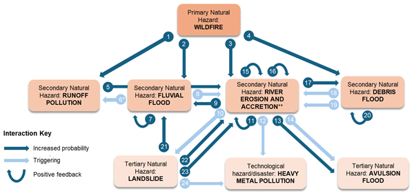
William Veness, Martha Day, Anthony C. Ross, Yazidhi Bamutaze, Jiayuan Han, Douglas Mulangwa, Andrew Mwesigwa, Emmanuel Ntale, Callist Tindimugaya, Brian Guma, Elisabeth Stephens, and Wouter Buytaert
Nat. Hazards Earth Syst. Sci., 26, 3045–3075, https://doi.org/10.5194/nhess-26-3045-2026, https://doi.org/10.5194/nhess-26-3045-2026, 2026
Short summary
Short summary
Climate change is driving wildfires to higher elevations in tropical mountains, exposing ecosystems with little or no fire history. We analyse a 2012 fire in Uganda’s Rwenzori Mountains that burned pristine forest and wetland above 3800 m, where no major fire had occurred for 12,000 years. The fire triggered a long-term cascade of floods, debris flows, landslides, erosion and mine-waste pollution, showing the need for rapid post-fire risk assessment and restoration.
Cinzia Mazzetti, Hannah Cloke, Dai Yamazaki, Gianpaolo Balsamo, Souhail Boussetta, Jasper Denissen, Michel Wortmann, Gabriele Arduini, Gurpreet Dass, Joe McNorton, Anna Agusti-Panareda, Maliko Tanguy, Ervin Zsoter, Margarita Choulga, Emanuel Dutra, Florian Pappenberger, Christoph Rüdiger, and Christel Prudhomme
EGUsphere, https://doi.org/10.5194/egusphere-2026-4305, https://doi.org/10.5194/egusphere-2026-4305, 2026
This preprint is open for discussion and under review for Geoscientific Model Development (GMD).
Short summary
Short summary
Rivers are an essential component of the water cycle, yet many Earth system and weather prediction models do not explicitly represent river flow. We integrated a global river model into ECMWF's forecasting system, enabling the simulation of river discharge, water levels, and flooding within a single operational framework. This development lays the foundation for future land–river–atmosphere interactions, paving the way for more complete Earth system models and improved predictions.
William Veness, Martha Day, Anthony C. Ross, Yazidhi Bamutaze, Jiayuan Han, Douglas Mulangwa, Andrew Mwesigwa, Emmanuel Ntale, Callist Tindimugaya, Brian Guma, Elisabeth Stephens, and Wouter Buytaert
Nat. Hazards Earth Syst. Sci., 26, 3045–3075, https://doi.org/10.5194/nhess-26-3045-2026, https://doi.org/10.5194/nhess-26-3045-2026, 2026
Short summary
Short summary
Climate change is driving wildfires to higher elevations in tropical mountains, exposing ecosystems with little or no fire history. We analyse a 2012 fire in Uganda’s Rwenzori Mountains that burned pristine forest and wetland above 3800 m, where no major fire had occurred for 12,000 years. The fire triggered a long-term cascade of floods, debris flows, landslides, erosion and mine-waste pollution, showing the need for rapid post-fire risk assessment and restoration.
Dorothy Heinrich, Erin Coughlan de Perez, Leanne Archer, Nadia Bloemendaal, Kevin I. Hodges, Helen Hooker, Theodore G. Shepherd, Nathan Sparks, Ralf Toumi, and Elisabeth Stephens
EGUsphere, https://doi.org/10.5194/egusphere-2026-2758, https://doi.org/10.5194/egusphere-2026-2758, 2026
Short summary
Short summary
An unprecedented tropical cyclone (TC) can turn into a disaster if it is unforeseen. In this work, we explore different TC datasets to identify simulated events that could be unprecedented. We look at whether these scenarios could be considered be plausible and how different these would be from past records, and illustrate with examples. We highlight that there is a wealth of scenarios that could be used by disaster managers to imagine and prepare for unprecedented events.
Karan Ruparell, Dai Yamazaki, Kieran Hunt, Hannah Cloke, Christel Prudhomme, Florian Pappenberger, and Matthew Chantry
EGUsphere, https://doi.org/10.5194/egusphere-2026-2909, https://doi.org/10.5194/egusphere-2026-2909, 2026
Short summary
Short summary
Reservoirs change how rivers behave, making them harder to predict. We tested whether machine learning models can learn these effects by training on river sites with and without upstream reservoirs across Great Britain. Models without reservoir training overestimated regulated flows, while reservoir-only models performed poorly on natural rivers. Training on both performed well everywhere. All models failed at heavily managed reservoirs where human decisions dominate river flow.
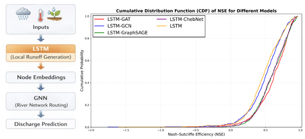
Hamidreza Mosaffa, Florian Pappenberger, Christel Prudhomme, Matthew Chantry, Christoph Rüdiger, and Hannah Cloke
Hydrol. Earth Syst. Sci., 30, 2079–2092, https://doi.org/10.5194/hess-30-2079-2026, https://doi.org/10.5194/hess-30-2079-2026, 2026
Short summary
Short summary
This study improves river flow prediction by combining two types of artificial intelligence models. One model estimates how rainfall becomes runoff in each part of a river basin, while another represents how water moves through the river network. By linking these processes, the approach better captures how water travels across large basins. The results show more accurate streamflow predictions, which can support water management and flood forecasting.
Fatima M. Pillosu, Mariana Claire, Calum Baugh, Florian Pappenberger, Christel Prudhome, and Hannah L. Cloke
EGUsphere, https://doi.org/10.5194/egusphere-2026-1591, https://doi.org/10.5194/egusphere-2026-1591, 2026
Short summary
Short summary
This paper presents the first global, medium-range probabilistic forecasts of flash flood occurrence. A single XGBoost model trained on coarse impact reports achieves skilful predictions, challenging assumptions that complex architectures and high-resolution data are required. At a time of heightened attention to flash flood risk and early warning, this work demonstrates that skilful global forecasting is achievable in data-sparse regions where flash flood risk is highest.
Jessica Rapson, Elisabeth Stephens, Ross I. Maidment, and Rogerio Bonifacio
EGUsphere, https://doi.org/10.5194/egusphere-2026-66, https://doi.org/10.5194/egusphere-2026-66, 2026
Short summary
Short summary
Extreme flooding is hard to predict in regions with limited data, yet early warnings are crucial to protect lives and livelihoods. This study developed an artificial intelligence system that learns from past weather, river levels, and satellite observations to predict where severe flooding will spread months in advance. Tested and used in real time in South Sudan, the system successfully supported humanitarian planning, showing it can improve preparedness and reduce the impacts of future floods.
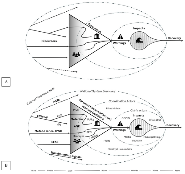
Jeff Da Costa, Elizabeth Ebert, David Hoffmann, Hannah L. Cloke, and Jessica Neumann
Nat. Hazards Earth Syst. Sci., 26, 343–366, https://doi.org/10.5194/nhess-26-343-2026, https://doi.org/10.5194/nhess-26-343-2026, 2026
Short summary
Short summary
This paper examines why multiple early indicators of the July 2021 floods in Luxembourg did not lead to better anticipatory action. Using a value chain approach and the Waterdrop Model, it identifies how thresholds, procedures, and institutional responsibilities limited the use of available forecast information under uncertainty. The findings show how aligning information with decision processes can improve timely disaster response.
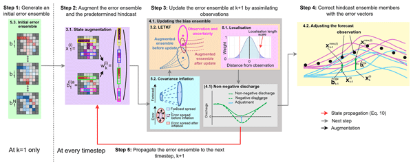
Gwyneth Matthews, Hannah L. Cloke, Sarah L. Dance, and Christel Prudhomme
Hydrol. Earth Syst. Sci., 29, 6157–6179, https://doi.org/10.5194/hess-29-6157-2025, https://doi.org/10.5194/hess-29-6157-2025, 2025
Short summary
Short summary
Forecasts provide information crucial for managing floods and for water resource planning, but they often have errors. “Post-processing” reduces these errors but is usually only applied at river gauges, leaving areas without gauges uncorrected. We developed a new method that uses spatial information contained within the forecast to spread information about the errors from gauged locations to ungauged areas. Our results show that the method successfully makes river forecasts more accurate.
Jeffrey Neal, Anthony Cooper, Stephen Chuter, Leanne Archer, Laura Devitt, Stephen Grey, Laurence Hawker, James Savage, Elisabeth Stephens, Calum Baugh, Tim Sumner, Katherine Marsden, and Tamara Janes
EGUsphere, https://doi.org/10.5194/egusphere-2025-3473, https://doi.org/10.5194/egusphere-2025-3473, 2025
Short summary
Short summary
East Africa has recently experienced a series of devastating tropical cyclone landfalls characterised by hundreds of fatalities, millions of displaced people and substantial economic damage. This paper describes an approach to forecasting the number of people directly exposed to flooding from tropical cyclones and documents experience gained communicating these forecasts to practitioners via emergency bulletins.
Joy Ommer, Milan Kalas, Jessica Neumann, Sophie Blackburn, and Hannah L. Cloke
Nat. Hazards Earth Syst. Sci., 25, 2929–2938, https://doi.org/10.5194/nhess-25-2929-2025, https://doi.org/10.5194/nhess-25-2929-2025, 2025
Short summary
Short summary
What do we regret about our disaster preparedness? This paper explores the regrets of 438 citizens who were affected by flooding in Germany in 2021. It shows that regret can primarily be associated with inaction (instead of actions), which contrasts with psychological studies from fields other than disaster science. The findings of this study suggest that the no-regret approach could be a suitable framework for moving towards longer-term disaster preparedness to reduce future regrets.
Emily Black, John Ellis, and Ross I. Maidment
Geosci. Model Dev., 17, 8353–8372, https://doi.org/10.5194/gmd-17-8353-2024, https://doi.org/10.5194/gmd-17-8353-2024, 2024
Short summary
Short summary
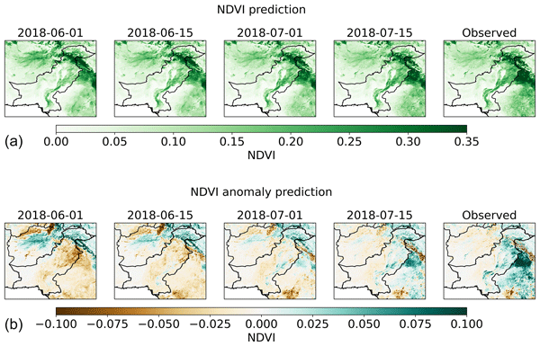
We present General TAMSAT-ALERT, a computationally lightweight and versatile tool for generating ensemble forecasts from time series data. General TAMSAT-ALERT is capable of combining multiple streams of monitoring and meteorological forecasting data into probabilistic hazard assessments. In this way, it complements existing systems and enhances their utility for actionable hazard assessment.
Joy Ommer, Jessica Neumann, Milan Kalas, Sophie Blackburn, and Hannah L. Cloke
Nat. Hazards Earth Syst. Sci., 24, 2633–2646, https://doi.org/10.5194/nhess-24-2633-2024, https://doi.org/10.5194/nhess-24-2633-2024, 2024
Short summary
Short summary
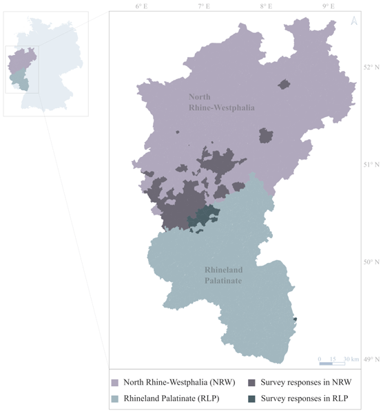
What’s the worst that could happen? Recent floods are often claimed to be beyond our imagination. Imagination is the picturing of a situation in our mind and the emotions that we connect with this situation. But why is this important for disasters? This survey found that when we cannot imagine a devastating flood, we are not preparing in advance. Severe-weather forecasts and warnings need to advance in order to trigger our imagination of what might happen and enable us to start preparing.
Solomon H. Gebrechorkos, Julian Leyland, Simon J. Dadson, Sagy Cohen, Louise Slater, Michel Wortmann, Philip J. Ashworth, Georgina L. Bennett, Richard Boothroyd, Hannah Cloke, Pauline Delorme, Helen Griffith, Richard Hardy, Laurence Hawker, Stuart McLelland, Jeffrey Neal, Andrew Nicholas, Andrew J. Tatem, Ellie Vahidi, Yinxue Liu, Justin Sheffield, Daniel R. Parsons, and Stephen E. Darby
Hydrol. Earth Syst. Sci., 28, 3099–3118, https://doi.org/10.5194/hess-28-3099-2024, https://doi.org/10.5194/hess-28-3099-2024, 2024
Short summary
Short summary
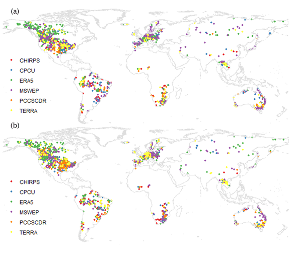
This study evaluated six high-resolution global precipitation datasets for hydrological modelling. MSWEP and ERA5 showed better performance, but spatial variability was high. The findings highlight the importance of careful dataset selection for river discharge modelling due to the lack of a universally superior dataset. Further improvements in global precipitation data products are needed.
Clare Lewis, Tim Smyth, Jess Neumann, and Hannah Cloke
Nat. Hazards Earth Syst. Sci., 24, 121–131, https://doi.org/10.5194/nhess-24-121-2024, https://doi.org/10.5194/nhess-24-121-2024, 2024
Short summary
Short summary
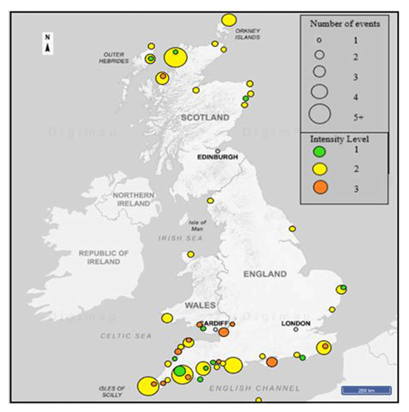
Meteotsunami are the result of atmospheric disturbances and can impact coastlines causing injury, loss of life, and damage to assets. This paper introduces a novel intensity index to allow for the quantification of these events at the shoreline. This has the potential to assist in the field of natural hazard assessment. It was trialled in the UK but designed for global applicability and to become a widely accepted standard in coastal planning, meteotsunami forecasting, and early warning systems.
Clare Lewis, Tim Smyth, David Williams, Jess Neumann, and Hannah Cloke
Nat. Hazards Earth Syst. Sci., 23, 2531–2546, https://doi.org/10.5194/nhess-23-2531-2023, https://doi.org/10.5194/nhess-23-2531-2023, 2023
Short summary
Short summary
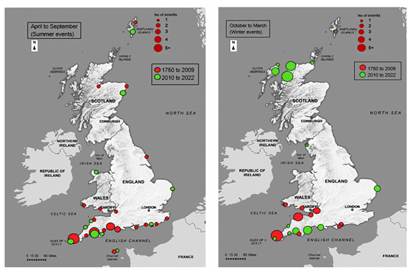
Meteotsunami are globally occurring water waves initiated by atmospheric disturbances. Previous research has suggested that in the UK, meteotsunami are a rare phenomenon and tend to occur in the summer months. This article presents a revised and updated catalogue of 98 meteotsunami that occurred between 1750 and 2022. Results also demonstrate a larger percentage of winter events and a geographical pattern highlighting the
hotspotregions that experience these events.
Shaun Harrigan, Ervin Zsoter, Hannah Cloke, Peter Salamon, and Christel Prudhomme
Hydrol. Earth Syst. Sci., 27, 1–19, https://doi.org/10.5194/hess-27-1-2023, https://doi.org/10.5194/hess-27-1-2023, 2023
Short summary
Short summary
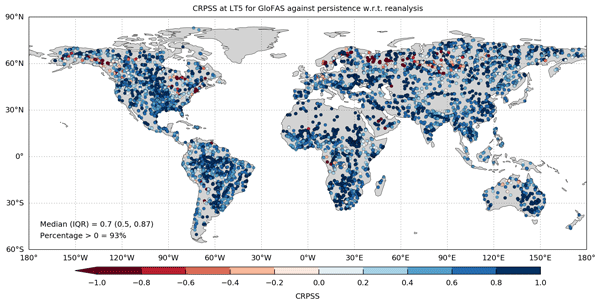
Real-time river discharge forecasts and reforecasts from the Global Flood Awareness System (GloFAS) have been made publicly available, together with an evaluation of forecast skill at the global scale. Results show that GloFAS is skillful in over 93 % of catchments in the short (1–3 d) and medium range (5–15 d) and skillful in over 80 % of catchments in the extended lead time (16–30 d). Skill is summarised in a new layer on the GloFAS Web Map Viewer to aid decision-making.
Gwyneth Matthews, Christopher Barnard, Hannah Cloke, Sarah L. Dance, Toni Jurlina, Cinzia Mazzetti, and Christel Prudhomme
Hydrol. Earth Syst. Sci., 26, 2939–2968, https://doi.org/10.5194/hess-26-2939-2022, https://doi.org/10.5194/hess-26-2939-2022, 2022
Short summary
Short summary
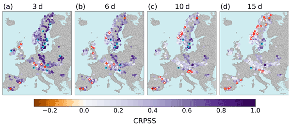
The European Flood Awareness System creates flood forecasts for up to 15 d in the future for the whole of Europe which are made available to local authorities. These forecasts can be erroneous because the weather forecasts include errors or because the hydrological model used does not represent the flow in the rivers correctly. We found that, by using recent observations and a model trained with past observations and forecasts, the real-time forecast can be corrected, thus becoming more useful.
Cited articles
Alfieri, L., Libertino, A., Campo, L., Dottori, F., Gabellani, S., Ghizzoni, T., Masoero, A., Rossi, L., Rudari, R., Testa, N., Trasforini, E., Amdihun, A., Ouma, J., Rossi, L., Tramblay, Y., Wu, H., and Massabò, M.: Impact-based flood forecasting in the Greater Horn of Africa, Nat. Hazards Earth Syst. Sci., 24, 199–224, https://doi.org/10.5194/nhess-24-199-2024, 2024.
Awange, J. L., Ogalo, L., Bae, K. H., Were, P., Omondi, P., Omute, P., and Omullo, M.: Falling Lake Victoria water levels: Is climate a contributing factor?, Clim. Change, 89, 281–297, https://doi.org/10.1007/s10584-008-9409-x, 2008.
Balasus, N., Jacob, D. J., Bloom, A. A., East, J. D., Estrada, L. A., Hancock, S. E., He, M., Mooring, T. A., Turner, A. J., and Worden, J. R.: 2019–2024 trends in African livestock and wetland emissions as contributors to the global methane rise, Atmos. Chem. Phys., 26, 4601–4617, https://doi.org/10.5194/acp-26-4601-2026, 2026.
Bamweyana, I., Musinguzi, M., and Kayondo, L. M.: Evaluation of CHIRPS satellite gridded dataset as an alternative rainfall estimate for localized modelling over Uganda, Atmos. Clim. Sci., 11, 797–811, https://doi.org/10.4236/acs.2021.114046, 2021.
Basheer, M. and Elagib, N. A.: Performance of satellite-based and GPCC 7.0 rainfall products in an extremely data-scarce country in the Nile Basin, Atmos. Res., 215, 128–140, https://doi.org/10.1016/j.atmosres.2018.08.028, 2019.
Beven, K. J.: Rainfall-Runoff Modelling: The Primer, 2nd edn., Wiley-Blackwell, Chichester, UK, 488 pp., https://doi.org/10.1002/9781119951001, 2012.
Black, E., Slingo, J., and Sperber, K. R.: An observational study of the relationship between excessively strong short rains in coastal East Africa and Indian Ocean SST, Mon. Weather Rev., 131, 74–94, https://doi.org/10.1175/1520-0493(2003)131<0074:AOSOTR>2.0.CO;2, 2003.
Brown, E. and Sutcliffe, J. V.: The water balance of Lake Kyoga, Uganda, Hydrol. Sci. J., 58, 342–353, https://doi.org/10.1080/02626667.2012.753148, 2013.
Bullock, A. and Acreman, M.: The role of wetlands in the hydrological cycle, Hydrol. Earth Syst. Sci., 7, 358–389, https://doi.org/10.5194/hess-7-358-2003, 2003.
Cai, W., Santoso, A., Wang, G., Weller, E., Wu, L., Ashok, K., Masumoto, Y., and Yamagata, T.: Increased frequency of extreme Indian Ocean Dipole events due to greenhouse warming, Nature, 510, 254–258, https://doi.org/10.1038/nature13327, 2014.
Cai, W., Wang, G., Gan, B., Wu, L., Santoso, A., Lin, X., Chen, Z., Jia, F., and Yamagata, T.: Stabilised frequency of extreme positive Indian Ocean Dipole under 1.5 °C warming, Nat. Commun., 9, https://doi.org/10.1038/s41467-018-03789-6, 2018.
Caldwell, S.: Flood Risk for South Sudan's 2022 Rainy Season, The Centre for Humanitarian Data, https://centre.humdata.org/flood-risks-for-south-sudans-2022-rainy-season/ (last access: 13 May 2026), 2022.
Camberlin, P. and Philippon, N.: The East African March–May rainy season: Associated atmospheric dynamics and predictability over the 1968–97 period, J. Climate, 15, 1002–1019, https://doi.org/10.1175/1520-0442(2002)015<1002:TEAMMR>2.0.CO;2, 2002.
Chaves-Gonzalez, J., Milano, L., Omtzigt, D.-J., Pfister, D., Poirier, J., Pople, A., Wittig, J., and Zommers, Z.: Anticipatory action: Lessons for the future, Front. Clim., 4, 932336, https://doi.org/10.3389/fclim.2022.932336, 2022.
Chow, V. T., Maidment, D. R., and Mays, L. W.: Applied Hydrology, McGraw-Hill, New York, USA, 572 pp., ISBN 978-0-07-010810-3, 1988.
Conway, D.: The climate and hydrology of the Upper Blue Nile River, Geogr. J., 166, 49–62, https://doi.org/10.1111/j.1475-4959.2000.tb00006.x, 2000.
Conway, D. and Hulme, M.: The impacts of climate variability and future climate change in the Nile Basin on water resources in Egypt, Int. J. Water Resour. Dev., 12, 277–296, https://doi.org/10.1080/07900629650178, 1996.
Coughlan de Perez, E., van den Hurk, B., van Aalst, M. K., Jongman, B., Klose, T., and Suarez, P.: Forecast-based financing: an approach for catalyzing humanitarian action based on extreme weather and climate forecasts, Nat. Hazards Earth Syst. Sci., 15, 895–904, https://doi.org/10.5194/nhess-15-895-2015, 2015.
Coughlan de Perez, E., van den Hurk, B., van Aalst, M. K., Amuron, I., Bamanya, D., Hauser, T., Jongma, B., Lopez, A., Mason, S., Mendler de Suarez, J., Pappenberger, F., Rueth, A., Stephens, E., Suarez, P., Wagemaker, J., and Zsoter, E.: Action-based flood forecasting for triggering humanitarian action, Hydrol. Earth Syst. Sci., 20, 3549–3560, https://doi.org/10.5194/hess-20-3549-2016, 2016.
Dinku, T., Ceccato, P., Grover-Kopec, E., Lemma, M., Connor, S. J., and Ropelewski, C. F.: Validation of satellite rainfall products over East Africa's complex topography, Int. J. Remote Sens., 28, 1503–1526, https://doi.org/10.1080/01431160600954688, 2007.
Dinku, T., Funk, C., Peterson, P., Maidment, R., Tadesse, T., Gadain, H., and Ceccato, P.: Validation of the CHIRPS satellite rainfall estimates over eastern Africa, Q. J. Roy. Meteor. Soc., 144, 292–312, https://doi.org/10.1002/qj.3244, 2018.
Donchyts, G., Schellekens, J., Winsemius, H., Eisemann, E., and van de Giesen, N.: A 30 m resolution surface water mask including estimation of positional and thematic differences using Landsat 8, SRTM and OpenStreetMap: A case study in the Murray–Darling Basin, Australia, Remote Sens., 8, 386, https://doi.org/10.3390/rs8050386, 2016.
Dong, B., Peng, S., Liu, G., Pu, T., Gerlein-Safdi, C., Prigent, C., and Lin, X.: Underestimation of methane emissions from the Sudd wetland: Unraveling the impact of wetland extent dynamics, Geophys. Res. Lett., 51, e2024GL110690, https://doi.org/10.1029/2024GL110690, 2024.
Dunning, C. M., Black, E. C. L., and Allan, R. P.: The onset and cessation of seasonal rainfall over Africa, J. Geophys. Res. Atmos., 121, 11405–11424, https://doi.org/10.1002/2016JD025428, 2016.
Dunning, C. M., Black, E., and Allan, R. P.: Later wet seasons with more intense rainfall over Africa under future climate change, J. Climate, 31, 9719–9738, https://doi.org/10.1175/JCLI-D-18-0102.1, 2018.
Easton-Calabria, E.: Possibilities and limitations of anticipatory action in complex crises: Acting in advance of flooding in South Sudan, Disasters, https://doi.org/10.1111/disa.12654, 2024.
Endris, H. S., Lennard, C., Hewitson, B., Dosio, A., Nikulin, G., and Artan, G. A.: Future changes in rainfall associated with ENSO, IOD and changes in the mean state over Eastern Africa, Clim. Dynam., 52, 2029–2053, https://doi.org/10.1007/s00382-018-4239-7, 2019.
European Space Agency (ESA): Copernicus Global Digital Elevation Model, OpenTopography [data set], https://doi.org/10.5069/G9028PQB, 2024.
Fisher, N. I.: Statistical Analysis of Circular Data, Cambridge University Press, Cambridge, UK, 277 pp., ISBN 978-0-521-56890-6, 1995.
Funk, C., Peterson, P., Landsfeld, M., Pedreros, D., Verdin, J., Shukla, S., Husak, G., Rowland, J., Harrison, L., Hoell, A., and Michaelsen, J.: The climate hazards infrared precipitation with stations: A new environmental record for monitoring extremes, Sci. Data, 2, 150066, https://doi.org/10.1038/sdata.2015.66, 2015.
Gebrechorkos, S. H., Hülsmann, S., and Bernhofer, C.: Evaluation of multiple climate data sources for managing environmental resources in East Africa, Hydrol. Earth Syst. Sci., 22, 4547–4564, https://doi.org/10.5194/hess-22-4547-2018, 2018.
Gibb, A.: A review of the hydrology of Lake Victoria and the Victoria Nile, Institute of Hydrology, Wallingford, UK, http://nora.nerc.ac.uk/507639/1/N507639CR.pdf (last access: 13 May 2026), 1984.
Hardy, A., Palmer, P. I., and Oakes, G.: Satellite data reveal how Sudd wetland dynamics are linked with globally significant methane emissions, Environ. Res. Lett., 18, https://doi.org/10.1088/1748-9326/ace272, 2023.
Hirabayashi, Y., Mahendran, R., Koirala, S., Konoshima, L., Yamazaki, D., Watanabe, S., Kim, H., and Kanae, S.: Global flood risk under climate change, Nat. Clim. Change, 3, 816–821, https://doi.org/10.1038/nclimate1911, 2013.
Hirabayashi, Y., Tanoue, M., Sasaki, O., Zhou, X., and Yamazaki, D.: Global exposure to flooding from the new CMIP6 climate model projections, Sci. Rep., 11, 3740, https://doi.org/10.1038/s41598-021-83279-w, 2021.
Howell, P. P., Lock, M., and Cobb, S. (Eds.): The Jonglei Canal: Impact and Opportunity, Cambridge University Press, Cambridge, UK, 537 pp., ISBN 978-0-521-30286-9, 1988.
Humanitarian Data Exchange: South Sudan: Rainfall Indicators at Subnational Level, HDX [data set], https://data.humdata.org/dataset/ssd-rainfall-subnational (last access: 10 June 2025), 2025.
Hurst, H. E. and Phillips, P.: The Hydrology of the Lake Plateau and Bahr el Jebel, The Nile Basin, Vol. V, Government Press, Cairo, Egypt, 251 pp., 1938.
IFRC: Operational Framework for Anticipatory Action 2021–2025, International Federation of Red Cross and Red Crescent Societies, https://www.ifrc.org/document/operational-framework-anticipatory-action-2021-2025 (last access: 13 May 2026), 2022.
IPCC: Climate Change 2021: The Physical Science Basis, Working Group I contribution to the Sixth Assessment Report of the Intergovernmental Panel on Climate Change, https://www.ipcc.ch/report/ar6/wg1/ (last access: 13 May 2026), 2021.
Jammalamadaka, S. R. and SenGupta, A.: Topics in Circular Statistics, Series on Multivariate Analysis, vol. 5, World Scientific Publishing, 336 pp., https://doi.org/10.1142/4031, 2001.
Johnson, D. H.: Reconstructing a history of local floods in the Upper Nile region of the Sudan, Int. J. Afr. Hist. Stud., 25, 607–616, https://doi.org/10.2307/219027, 1992.
Junk, W. J., Bayley, P. B., and Sparks, R. E.: The flood pulse concept in river-floodplain systems, in: Proceedings of the International Large River Symposium, edited by: Dodge, D. P., Canadian Special Publication of Fisheries and Aquatic Sciences, 106, 110–127, ISBN 9780660132594, 1989.
Junk, W. J., An, S., Finlayson, C. M., Gopal, B., Květ, J., Mitchell, S. A., Mitsch, W. J., and Robarts, R. D.: Current state of knowledge regarding the world's wetlands and their future under global climate change: A synthesis, Aquat. Sci., 75, 151–167, https://doi.org/10.1007/s00027-012-0278-z, 2013.
Kadykalo, A. N. and Findlay, C. S.: The flow regulation services of wetlands, Ecosyst. Serv., 20, 91–103, https://doi.org/10.1016/j.ecoser.2016.06.005, 2016.
Kite, G. W.: Analysis of Lake Victoria levels, Hydrol. Sci. J., 27, 99–110, https://doi.org/10.1080/02626668209491093, 1982.
Kenya Meteorological Department (KMD): State of the Climate Kenya 2022, Kenya Meteorological Department, Nairobi, Kenya, https://meteo.go.ke/wp-content/uploads/2023/06/State-of-the-Climate-Kenya-2022.pdf (last access: 13 May 2026), 2023.
Kolstad, E. W., MacLeod, D., and Demissie, T. D.: Drivers of subseasonal forecast errors of the East African short rains, Geophys. Res. Lett., 48, e2021GL093292, https://doi.org/10.1029/2021GL093292, 2021.
Kull, D.: Connections between recent water level drops in Lake Victoria, dam operations and drought, International Rivers Network, http://www.internationalrivers.org/files/attached-files/full_report_pdf.pdf (last access: 13 May 2026), 2006.
Laaha, G., Gauster, T., Tallaksen, L. M., Vidal, J.-P., Stahl, K., Prudhomme, C., Heudorfer, B., Vlnas, R., Ionita, M., Van Lanen, H. A. J., Adler, M.-J., Caillouet, L., Delus, C., Fendekova, M., Gailliez, S., Hannaford, J., Kingston, D., Van Loon, A. F., Mediero, L., Osuch, M., Romanowicz, R., Sauquet, E., Stagge, J. H., and Wong, W. K.: The European 2015 drought from a hydrological perspective, Hydrol. Earth Syst. Sci., 21, 3001–3024, https://doi.org/10.5194/hess-21-3001-2017, 2017.
Lamberts, E.: The effects of Jonglei Canal operation scenarios on the Sudd swamps in Southern Sudan, M.Sc. thesis, University of Twente, Enschede, the Netherlands, 64 pp., https://essay.utwente.nl/fileshare/file/59163/scriptie_E_Lamberts.pdf (last access: 12 May 2026), 2009.
Lin, L., Di, L., Tang, J., Yu, E., Zhang, C., Rahman, M. S., Shrestha, R., and Kang, L.: Improvement and validation of NASA/MODIS NRT global flood mapping, Remote Sens., 11, 205, https://doi.org/10.3390/rs11020205, 2019.
Manatsa, D. and Behera, S. K.: On the epochal strengthening in the relationship between rainfall of East Africa and IOD, J. Climate, 26, 5655–5673, https://doi.org/10.1175/JCLI-D-12-00568.1, 2013.
Manatsa, D., Chipindu, B., and Behera, S. K.: Shifts in IOD and their impacts on association with East Africa rainfall, Theor. Appl. Climatol., 110, 115–128, https://doi.org/10.1007/s00704-012-0610-5, 2012.
Marthews, T. R., Dadson, S. J., Clark, D. B., Blyth, E. M., Hayman, G. D., Yamazaki, D., Becher, O. R. E., Martínez-de la Torre, A., Prigent, C., and Jiménez, C.: Inundation prediction in tropical wetlands from JULES-CaMa-Flood global land surface simulations, Hydrol. Earth Syst. Sci., 26, 3151–3175, https://doi.org/10.5194/hess-26-3151-2022, 2022.
McDonnell, J. J. and Beven, K.: Debates: The future of hydrological sciences: A (common) path forward? A call to action aimed at understanding velocities, celerities and residence time distributions of the headwater hydrograph, Water Resour. Res., 50, 5342–5350, https://doi.org/10.1002/2013WR015141, 2014.
Mertes, L. A. K.: Documentation and significance of the perirheic zone on inundated floodplains, Water Resour. Res., 33, 1749–1762, https://doi.org/10.1029/97WR00658, 1997.
Mistry, V. V. and Conway, D.: Remote forcing of East African rainfall and relationships with fluctuations in levels of Lake Victoria, Int. J. Climatol., 23, 67–89, https://doi.org/10.1002/joc.861, 2003.
Mohamed, Y. A. and Savenije, H. H. G.: Impact of climate variability on the hydrology of the Sudd wetland: Signals derived from long term (1900–2000) water balance computations, Wetl. Ecol. Manag., 22, 191–198, https://doi.org/10.1007/S11273-014-9337-7, 2014.
Mohamed, Y. A., van den Hurk, B. J. J. M., Savenije, H. H. G., and Bastiaanssen, W. G. M.: Hydroclimatology of the Nile: results from a regional climate model, Hydrol. Earth Syst. Sci., 9, 263–278, https://doi.org/10.5194/hess-9-263-2005, 2005a.
Mohamed, Y. A., van den Hurk, B. J. J. M., Savenije, H. H. G., and Bastiaanssen, W. G. M.: Impact of the Sudd wetland on the Nile hydroclimatology, Water Resour. Res., 41, W08405, https://doi.org/10.1029/2004WR003792, 2005b.
Mueller, N., Lewis, A., Roberts, D., Ring, S., Melrose, R., Sixsmith, J., Lymburner, L., McIntyre, A., Tan, P., Curnow, S., and Ip, A.: Water observations from space: Mapping surface water from 25 years of Landsat imagery across Australia, Remote Sens. Environ., 174, 341–352, https://doi.org/10.1016/j.rse.2015.11.003, 2016.
Mugume, S. N., Abasabyoona, G., Engwau, J., Sempewo, J., van de Sande, B., and Butler, D.: Assessment of the impact of the rise in Lake Victoria water levels on urban flooding using a GIS-based spatial flood modelling approach, Urban Water J., 21, 219–233, https://doi.org/10.1080/1573062X.2023.2284960, 2024.
NASA Goddard Space Flight Center: Global Water Monitor, Lake Victoria 1 (000314), https://earth.gsfc.nasa.gov/gwm/lake/314 (last access: 13 May 2026), 2025.
Nicholson, S. E.: The predictability of rainfall over the Greater Horn of Africa, Part I: Prediction of seasonal rainfall, J. Hydrometeorol., 15, 1011–1027, https://doi.org/10.1175/JHM-D-13-062.1, 2014.
Nicholson, S. E.: Climate and climatic variability of rainfall over eastern Africa, Rev. Geophys., 55, 590–635, https://doi.org/10.1002/2016RG000544, 2017.
Nicholson, S. E. and Yin, X.: Rainfall conditions in equatorial East Africa during the nineteenth century as inferred from the record of Lake Victoria, Clim. Change, 48, 387–398, https://doi.org/10.1023/A:1010736008362, 2001.
Nicholson, S. E., Klotter, D., and Hartman, A. T.: Lake-effect rains over Lake Victoria and their association with mesoscale convective systems, J. Hydrometeorol., 22, 1353–1368, https://doi.org/10.1175/JHM-D-20-0244.1, 2021.
Nile Basin Initiative/Nile Equatorial Lakes Subsidiary Action Program (NELSAP): Integrated Lakes Management Plan (ILMP) for the Fisheries and Ecosystems of Lakes Edward and Albert, Final Report, Volume 1, Lakes Edward and Albert Fisheries (LEAF) Pilot Project, submitted by Development Consultants International Limited (DCI) Consortium, 146 pp., https://nilebasin.org/node/12562 (last access: 13 August 2026), 2008.
Pappenberger, F., Beven, K. J., Hunter, N. M., Bates, P. D., Gouweleeuw, B. T., Thielen, J., and de Roo, A. P. J.: Cascading model uncertainty from medium range weather forecasts (10 days) through a rainfall-runoff model to flood inundation predictions within the European Flood Forecasting System (EFFS), Hydrol. Earth Syst. Sci., 9, 381–393, https://doi.org/10.5194/hess-9-381-2005, 2005.
Pekel, J. F., Cottam, A., Gorelick, N., and Belward, A. S.: High-resolution mapping of global surface water and its long-term changes, Nature, 540, 418–422, https://doi.org/10.1038/nature20584, 2016.
Pietroiusti, R., Vanderkelen, I., Otto, F. E. L., Barnes, C., Temple, L., Akurut, M., Bally, P., van Lipzig, N. P. M., and Thiery, W.: Possible role of anthropogenic climate change in the record-breaking 2020 Lake Victoria levels and floods, Earth Syst. Dynam., 15, 225–264, https://doi.org/10.5194/esd-15-225-2024, 2024.
Ramsar Secretariat: Sudd, Ramsar Sites Information Service, https://rsis.ramsar.org/ris/1622 (last access: 10 June 2024), 2006.
Ratna, S. B., Cherchi, A., Osborn, T. J., Joshi, M., and Uppara, U.: The extreme positive Indian Ocean Dipole of 2019 and associated Indian summer monsoon rainfall response, Geophys. Res. Lett., 48, e2020GL091497, https://doi.org/10.1029/2020GL091497, 2021.
Rebelo, L. M., Senay, G. B., and McCartney, M. P.: Flood pulsing in the Sudd wetland: Analysis of seasonal variations in inundation and evaporation in South Sudan, Earth Interact., 16, 1–19, https://doi.org/10.1175/2011EI382.1, 2012.
Rientjes, T. H. M., Haile, A. T., Kebede, E., Mannaerts, C. M. M., Habib, E., and Steenhuis, T. S.: Changes in land cover, rainfall and stream flow in Upper Gilgel Abbay catchment, Blue Nile basin – Ethiopia, Hydrol. Earth Syst. Sci., 15, 1979–1989, https://doi.org/10.5194/hess-15-1979-2011, 2011.
Roxy, M., Gualdi, S., Drbohlav, H. K. L., and Navarra, A.: Seasonality in the relationship between El Niño and Indian Ocean Dipole, Clim. Dynam., 37, 221–236, https://doi.org/10.1007/s00382-010-0876-1, 2011.
Sene, K. J.: Theoretical estimates for the influence of Lake Victoria on flows in the Upper White Nile, Hydrol. Sci. J., 45, 125–145, https://doi.org/10.1080/02626660009492310, 2000.
Stephens, E., Coughlan de Perez, E., Kruczkiewicz, A., Boyd, E., and Suarez, P.: Forecast-based Action, University of Reading, Red Cross Red Crescent Climate Centre, and International Research Institute for Climate and Society, https://www.climatecentre.org/wp-content/uploads/RCCC-FbA-Report.pdf (last access: 9 May 2024), 2015.
Sutcliffe, J. and Brown, E.: Water losses from the Sudd, Hydrol. Sci. J., 63, 527–541, https://doi.org/10.1080/02626667.2018.1438612, 2018.
Sutcliffe, J. V.: A hydrological study of the southern Sudd region of the Upper Nile, Hydrol. Sci. Bull., 19, 237–255, https://doi.org/10.1080/02626667409493903, 1974.
Sutcliffe, J. V. and Parks, Y. P.: The Hydrology of the Nile, IAHS Special Publication No. 5, International Association of Hydrological Sciences (IAHS Press), Wallingford, Oxfordshire, UK, ISBN 1-901502-75-9, 1999.
Swenson, S. and Wahr, J.: Monitoring the water balance of Lake Victoria, East Africa, from space, J. Hydrol., 370, 163–176, https://doi.org/10.1016/j.jhydrol.2009.03.008, 2009.
Tate, E., Sutcliffe, J., Conway, D., and Farquharson, F.: Water balance of Lake Victoria: Update to 2000 and climate change modelling to 2100, Hydrol. Sci. J., 49, 563–574, https://doi.org/10.1623/hysj.49.4.563.54422, 2004.
Tekleab, S., Mohamed, Y., and Uhlenbrook, S.: Hydro-climatic trends in the Abay/Upper Blue Nile basin, Ethiopia, Phys. Chem. Earth, 61–62, 32–42, https://doi.org/10.1016/j.pce.2013.04.017, 2013.
Tekleab, S., Uhlenbrook, S., Mohamed, Y., Savenije, H. H. G., Temesgen, M., and Wenninger, J.: Water balance modeling of Upper Blue Nile catchments using a top-down approach, Hydrol. Earth Syst. Sci., 15, 2179–2193, https://doi.org/10.5194/hess-15-2179-2011, 2011.
Thiemig, V., Rojas, R., Zambrano-Bigiarini, M., Levizzani, V., and de Roo, A.: Validation of satellite-based precipitation products over sparsely gauged African river basins, J. Hydrometeorol., 13, 1760–1783, https://doi.org/10.1175/JHM-D-12-032.1, 2012.
Ticehurst, C., Guerschman, J. P., and Chen, Y.: The strengths and limitations in using the daily MODIS open water likelihood algorithm for identifying flood events, Remote Sens., 6, 11791–11809, https://doi.org/10.3390/rs61211791, 2014.
Uganda National Meteorological Authority (UNMA): The State of Climate of Uganda in 2022, Uganda National Meteorological Authority, Kampala, Uganda, https://mwe.go.ug/publications/meteorological/state-of-uganda-climate-in-2022 (last access: 18 August 2026), 2022.
Ummenhofer, C. C., Gupta, A. S., England, M. H., and Reason, C. J. C.: Contributions of Indian Ocean sea surface temperatures to enhanced East African rainfall, J. Climate, 22, 993–1013, https://doi.org/10.1175/2008JCLI2493.1, 2009.
UNESCO: Sudd wetland, UNESCO World Heritage Centre Tentative Lists, https://whc.unesco.org/en/tentativelists/6276/ (last access: 14 August 2024), 2017.
UNHCR: UNHCR warns of dire impact from floods in South Sudan as new wet season looms, UNHCR Briefing Notes, https://www.unhcr.org/news/briefing-notes/unhcr-warns-dire-impact-floods-south-sudan-new-wet-season-looms (last access: 9 August 2024), 2022.
Vanderkelen, I., van Lipzig, N. P. M., and Thiery, W.: Modelling the water balance of Lake Victoria (East Africa) – Part 1: Observational analysis, Hydrol. Earth Syst. Sci., 22, 5509–5525, https://doi.org/10.5194/hess-22-5509-2018, 2018a.
Vanderkelen, I., van Lipzig, N. P. M., and Thiery, W.: Modelling the water balance of Lake Victoria (East Africa) – Part 2: Future projections, Hydrol. Earth Syst. Sci., 22, 5527–5549, https://doi.org/10.5194/hess-22-5527-2018, 2018b.
Van Lanen, H. A. J., Wanders, N., Tallaksen, L. M., and Van Loon, A. F.: Hydrological drought across the world: impact of climate and physical catchment structure, Hydrol. Earth Syst. Sci., 17, 1715–1732, https://doi.org/10.5194/hess-17-1715-2013, 2013.
Van Loon, A. F. and Laaha, G.: Hydrological drought severity explained by climate and catchment characteristics, J. Hydrol., 526, 3–14, https://doi.org/10.1016/j.jhydrol.2014.10.059, 2015.
Wainwright, C. M., Finney, D. L., Kilavi, M., Black, E., and Marsham, J. H.: Extreme rainfall in East Africa, October 2019–January 2020 and context under future climate change, Weather, 76, 26–31, https://doi.org/10.1002/wea.3824, 2021.
Wenhaji Ndomeni, C., Cattani, E., Merino, A., and Levizzani, V.: An observational study of the variability of East African rainfall with respect to sea surface temperature and soil moisture, Q. J. Roy. Meteor. Soc., 144, 384–404, https://doi.org/10.1002/qj.3255, 2018.
Wilks, D. S.: Statistical Methods in the Atmospheric Sciences, 3rd edn., Vol. 100, Academic Press, Oxford, UK, ISBN 9780123850225, 2011.
Williams, M.: The Sudd swamps and the White Nile, in: The Nile Basin, Cambridge University Press, Cambridge, UK, 107–126, https://doi.org/10.1017/9781316831885.009, 2018.
WMO: Guide to Hydrological Practices: Data Acquisition and Processing, Analysis, Forecasting and Other Applications, 5th edn., WMO-No. 168, World Meteorological Organization, Geneva, Switzerland, 1994.
WMO (World Meteorological Organization): State of the Climate in Africa 2022, WMO-No. 1330, Geneva, Switzerland, 2023.
Zakaria Lukwasa, A., Ayal, D. Y., Zeleke, T. T., and Beketie, K. T.: Spatio-temporal rainfall variability and its linkage with large scale climate oscillations over the Republic of South Sudan, Clim. Serv., 28, 100322, https://doi.org/10.1016/j.cliser.2022.100322, 2022.
Zhang, T., Dong, Z., Wang, W., Qian, Z., Zhang, J., Lu, P., Han, Y., Li, Z., Ji, J., Hou, Y., and Li, H.: Flood risk assessment in data-scarce South Sudan using a flood modeling framework, J. Hydrol. Reg. Stud., 61, 102743, https://doi.org/10.1016/j.ejrh.2025.102743, 2025.
Zhang, X., Bi, Z., Sun, X., Wang, P., Xu, Z., and Jia, B.: Backwater effects in rivers and lakes: Case study of Dongping Lake in China, Water, 15, 3850, https://doi.org/10.3390/w15213850, 2023.
Short summary
This study traced how water moved from Lake Victoria to the Sudd wetlands to explain the prolonged flooding in South Sudan between 2019 and 2024. Using satellite observations, rainfall records, and lake and river measurements, we found that water takes about 17 months to travel through the system, much longer than previously assumed 5 months. The results show that lakes and wetlands can store and slowly release water over several years, helping improve flood forecasting and early warning.
This study traced how water moved from Lake Victoria to the Sudd wetlands to explain...


