
Articles | Volume 30, issue 21
https://doi.org/10.5194/hess-30-6701-2026
© Author(s) 2026. This work is distributed under
the Creative Commons Attribution 4.0 License.
the Creative Commons Attribution 4.0 License.
https://doi.org/10.5194/hess-30-6701-2026
© Author(s) 2026. This work is distributed under
the Creative Commons Attribution 4.0 License.
the Creative Commons Attribution 4.0 License.
Research article
| 
30 Oct 2026
Research article |
| 30 Oct 2026
| 30 Oct 2026
Design and trial implementation of a continental-scale, kilometre-resolution hourly precipitation analysis for Australia using satellite, radar and gauges
Yuhang Zhang
Department of Infrastructure Engineering, The University of Melbourne, Parkville, VIC 3010, Australia

College of Hydrology and Water Resources, Hohai University, Nanjing 210098, China
Department of Infrastructure Engineering, The University of Melbourne, Parkville, VIC 3010, Australia
Andrew J. Frost
CORRESPONDING AUTHOR
Bureau of Meteorology, Sydney, NSW 1300, Australia
Jayaram Pudashine
Bureau of Meteorology, Melbourne, VIC 3001, Australia
Blair Trewin
Bureau of Meteorology, Melbourne, VIC 3001, Australia
Carlos Velasco-Forero
Bureau of Meteorology, Melbourne, VIC 3001, Australia
Chun-Hsu Su
Bureau of Meteorology, Melbourne, VIC 3001, Australia
Vincent Villani
Bureau of Meteorology, Melbourne, VIC 3001, Australia
Related authors
Yuhang Zhang, Aizhong Ye, Bita Analui, Phu Nguyen, Soroosh Sorooshian, Kuolin Hsu, and Yuxuan Wang
Hydrol. Earth Syst. Sci., 27, 4529–4550, https://doi.org/10.5194/hess-27-4529-2023, https://doi.org/10.5194/hess-27-4529-2023, 2023
Short summary
Short summary
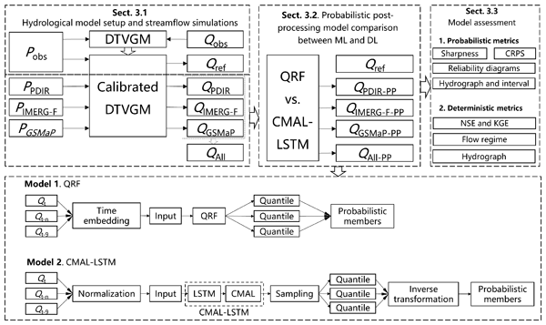
Our study shows that while the quantile regression forest (QRF) and countable mixtures of asymmetric Laplacians long short-term memory (CMAL-LSTM) models demonstrate similar proficiency in multipoint probabilistic predictions, QRF excels in smaller watersheds and CMAL-LSTM in larger ones. CMAL-LSTM performs better in single-point deterministic predictions, whereas QRF model is more efficient overall.
Jiawei Hou, Wendy Sharples, Jayaram Pudashine, Mandi Thran, Carlos Velasco-Forero, Paul Fox-Hughes, Elisabetta Carrara, and Holger R. Maier
EGUsphere, https://doi.org/10.5194/egusphere-2026-3401, https://doi.org/10.5194/egusphere-2026-3401, 2026
Short summary
Short summary
Floods can develop rapidly, leaving little time for communities and emergency services to respond. This study uses deep learning and radar data to forecast river levels from 90 minutes to 12 hours in advance and generate high-resolution flood inundation maps. Tested across different flood regimes in eastern Australia, the approach produced accurate and timely flood forecasts, demonstrating its potential to improve flood preparedness, emergency response, and community safety.
Piers M. Forster, Tristram Walsh, Chris Smith, William F. Lamb, Robin Lamboll, Christophe Cassou, Mathias Hauser, Zeke Hausfather, June-Yi Lee, Matthew D. Palmer, Karina von Schuckmann, Aimée B. A. Slangen, Sophie Szopa, Blair Trewin, Jeongeun Yun, Nathan P. Gillett, Stuart Jenkins, H. Damon Matthews, Krishnan Raghavan, Aurélien Ribes, Joeri Rogelj, Debbie Rosen, Xuebin Zhang, Myles Allen, Robbie M. Andrew, Chris Atkinson, Richard A. Betts, Antonio Bombelli, Samantha N. Burgess, Lijing Cheng, Helen E. Claxton, Pierre Friedlingstein, Thomas L. Frölicher, Catia M. Domingues, Thomas Gasser, Catherine H. Gregory, Rachel M. Hoesly, Daniel Huppmann, Masayoshi Ishii, Christopher Kadow, Alexia Karwat, John Kennedy, Rachel E. Killick, Mahesh V. M. Kovilakam, Paul B. Krummel, Xin Lan, Jean-François Lamarque, Aurélien Liné, Belén Martín-Míguez, Didier P. Monselesan, Colin Morice, Jens Mühle, Pino Mussak, Glen P. Peters, Anna Pirani, Julia Pongratz, Matthew Rigby, Robert Rohde, Abhishek Savita, Sonia I. Seneviratne, Steven J. Smith, Ghassan Taha, Caterina Tassone, Peter Thorne, Christopher Wells, Luke M. Western, Guido R. van der Werf, Susan E. Wijffels, Marco Zecchetto, Junting Zhong, Xiao-Ye Zhang, Valérie Masson-Delmotte, and Panmao Zhai
Earth Syst. Sci. Data, 18, 3889–3933, https://doi.org/10.5194/essd-18-3889-2026, https://doi.org/10.5194/essd-18-3889-2026, 2026
Short summary
Short summary
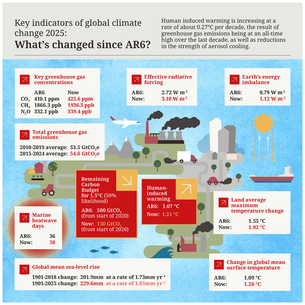
We give our annual update of key climate indicators. Our work quantifies the human contribution to global warming and the pace of climate change. This represents a large effort by the international community akin to an Intergovernmental Panel on Climate Change (IPCC) report.
Ashkan Shokri, James C. Bennett, David E. Robertson, Jean-Michel Perraud, Andrew J. Frost, and Eric A. Lehmann
Hydrol. Earth Syst. Sci., 30, 757–777, https://doi.org/10.5194/hess-30-757-2026, https://doi.org/10.5194/hess-30-757-2026, 2026
Short summary
Short summary
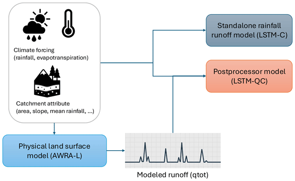
Predicting river flow accurately is crucial for managing water resources, especially in a changing climate. This study used deep learning to improve streamflow predictions across Australia. By either enhancing existing models or working independently with climate data, the deep learning approaches provided more reliable results than traditional methods. These findings can help water managers better plan for floods, droughts, and long-term water availability.
Peter W. Thorne, John M. Nicklas, John J. Kennedy, Bruce Calvert, Baylor Fox-Kemper, Mark T. Richardson, Adrian Simmons, Ed Hawkins, Robert Rhode, Kathryn Cowtan, Nerilie J. Abram, Axel Andersson, Simon Noone, Phillipe Marbaix, Nathan Lenssen, Dirk Olonscheck, Tristram Walsh, Stephen Outten, Ingo Bethke, Bjorn H. Samset, Chris Smith, Anna Pirani, Jan Fuglestvedt, Lavanya Rajamani, Richard A. Betts, Elizabeth C. Kent, Blair Trewin, Colin Morice, Tim Osborn, Samantha N. Burgess, Oliver Geden, Andrew Parnell, Piers M. Forster, Chris Hewitt, Zeke Hausfather, Valerie Masson-Delmotte, Jochem Marotzke, Nathan Gillett, Sonia I. Seneviratne, Gavin A. Schmidt, Duo Chan, Stefan Brönnimann, Andy Reisinger, Matthew Menne, Maisa Rojas Corradi, Christopher Kadow, Peter Huybers, David B. Stephenson, Emily Wallis, Joeri Rogelj, Andrew Schurer, Karen McKinnon, Panmao Zhai, Fatima Driouech, Wilfran Moufouma Okia, Saeed Vazifehkhah, Sophie Szopa, Christopher J. Merchant, Shoji Hirahara, Masayoshi Ishii, Francois A. Engelbrecht, Qingxiang Li, June-Yi Lee, Alex J. Cannon, Christophe Cassou, Karina von Schuckmann, Amir H. Delju, and Ellie Murtagh
Earth Syst. Sci. Data Discuss., https://doi.org/10.5194/essd-2025-825, https://doi.org/10.5194/essd-2025-825, 2026
Revised manuscript accepted for ESSD
Short summary
Short summary
We reassess the basis for determining the present level of long-term global warming. Unbiased estimates of both realised warming and anthropogenic warming are possible that approximate a 20-year retrospective mean. Our resulting estimates of 1.40 [1.23–1.58] °C (realised) and 1.34 [1.18–1.50] °C (anthropogenic) as at end of 2024 highlight the urgency of immediate, far-reaching and sustained climate mitigation actions if we are to meet the long term temperature goal of the Paris Agreement.

Jiaquan Wan, Xing Wang, Yannian Cheng, Cuiyan Zhang, Fengchang Xue, Tao Yang, Fei Tong, and Quan J. Wang
Nat. Hazards Earth Syst. Sci., 25, 4361–4373, https://doi.org/10.5194/nhess-25-4361-2025, https://doi.org/10.5194/nhess-25-4361-2025, 2025
Short summary
Short summary
Urban flooding is a growing issue in cities, often disrupting daily life, especially at night, when the extent of flooding is harder to identify. This study introduces NWseg, a new deep learning model designed to identify the extent of urban flooding at night. Using a dataset of 4000 nighttime images, we found that NWseg outperforms existing models in accuracy. This research offers a practical solution for real-time flood monitoring, helping improve urban disaster response and management.
Mike Bush, David L. A. Flack, Huw W. Lewis, Sylvia I. Bohnenstengel, Chris J. Short, Charmaine Franklin, Adrian P. Lock, Martin Best, Paul Field, Anne McCabe, Kwinten Van Weverberg, Segolene Berthou, Ian Boutle, Jennifer K. Brooke, Seb Cole, Shaun Cooper, Gareth Dow, John Edwards, Anke Finnenkoetter, Kalli Furtado, Kate Halladay, Kirsty Hanley, Margaret A. Hendry, Adrian Hill, Aravindakshan Jayakumar, Richard W. Jones, Humphrey Lean, Joshua C. K. Lee, Andy Malcolm, Marion Mittermaier, Saji Mohandas, Stuart Moore, Cyril Morcrette, Rachel North, Aurore Porson, Susan Rennie, Nigel Roberts, Belinda Roux, Claudio Sanchez, Chun-Hsu Su, Simon Tucker, Simon Vosper, David Walters, James Warner, Stuart Webster, Mark Weeks, Jonathan Wilkinson, Michael Whitall, Keith D. Williams, and Hugh Zhang
Geosci. Model Dev., 18, 3819–3855, https://doi.org/10.5194/gmd-18-3819-2025, https://doi.org/10.5194/gmd-18-3819-2025, 2025
Short summary
Short summary
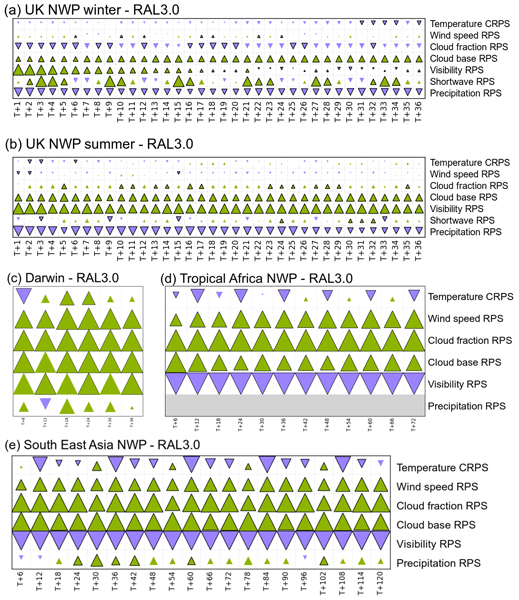
RAL configurations define settings for the Unified Model atmosphere and Joint UK Land Environment Simulator. The third version of the Regional Atmosphere and Land (RAL3) science configuration for kilometre- and sub-kilometre-scale modelling represents a major advance compared to previous versions (RAL2) by delivering a common science definition for applications in tropical and mid-latitude regions. RAL3 has more realistic precipitation distributions and an improved representation of clouds and visibility.
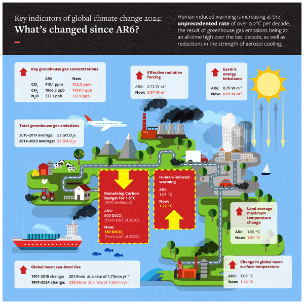
Piers M. Forster, Chris Smith, Tristram Walsh, William F. Lamb, Robin Lamboll, Christophe Cassou, Mathias Hauser, Zeke Hausfather, June-Yi Lee, Matthew D. Palmer, Karina von Schuckmann, Aimée B. A. Slangen, Sophie Szopa, Blair Trewin, Jeongeun Yun, Nathan P. Gillett, Stuart Jenkins, H. Damon Matthews, Krishnan Raghavan, Aurélien Ribes, Joeri Rogelj, Debbie Rosen, Xuebin Zhang, Myles Allen, Lara Aleluia Reis, Robbie M. Andrew, Richard A. Betts, Alex Borger, Jiddu A. Broersma, Samantha N. Burgess, Lijing Cheng, Pierre Friedlingstein, Catia M. Domingues, Marco Gambarini, Thomas Gasser, Johannes Gütschow, Masayoshi Ishii, Christopher Kadow, John Kennedy, Rachel E. Killick, Paul B. Krummel, Aurélien Liné, Didier P. Monselesan, Colin Morice, Jens Mühle, Vaishali Naik, Glen P. Peters, Anna Pirani, Julia Pongratz, Jan C. Minx, Matthew Rigby, Robert Rohde, Abhishek Savita, Sonia I. Seneviratne, Peter Thorne, Christopher Wells, Luke M. Western, Guido R. van der Werf, Susan E. Wijffels, Valérie Masson-Delmotte, and Panmao Zhai
Earth Syst. Sci. Data, 17, 2641–2680, https://doi.org/10.5194/essd-17-2641-2025, https://doi.org/10.5194/essd-17-2641-2025, 2025
Short summary
Short summary
In a rapidly changing climate, evidence-based decision-making benefits from up-to-date and timely information. Here we compile monitoring datasets to track real-world changes over time. To make our work relevant to policymakers, we follow methods from the Intergovernmental Panel on Climate Change (IPCC). Human activities are increasing the Earth's energy imbalance and driving faster sea-level rise compared to the IPCC assessment.
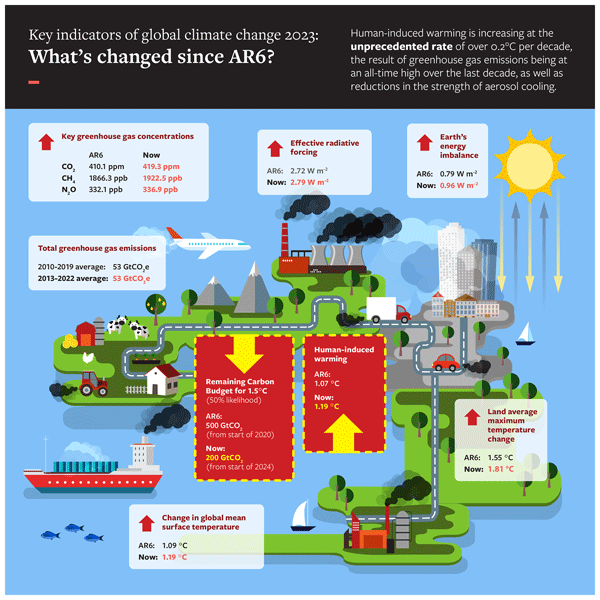
Piers M. Forster, Chris Smith, Tristram Walsh, William F. Lamb, Robin Lamboll, Bradley Hall, Mathias Hauser, Aurélien Ribes, Debbie Rosen, Nathan P. Gillett, Matthew D. Palmer, Joeri Rogelj, Karina von Schuckmann, Blair Trewin, Myles Allen, Robbie Andrew, Richard A. Betts, Alex Borger, Tim Boyer, Jiddu A. Broersma, Carlo Buontempo, Samantha Burgess, Chiara Cagnazzo, Lijing Cheng, Pierre Friedlingstein, Andrew Gettelman, Johannes Gütschow, Masayoshi Ishii, Stuart Jenkins, Xin Lan, Colin Morice, Jens Mühle, Christopher Kadow, John Kennedy, Rachel E. Killick, Paul B. Krummel, Jan C. Minx, Gunnar Myhre, Vaishali Naik, Glen P. Peters, Anna Pirani, Julia Pongratz, Carl-Friedrich Schleussner, Sonia I. Seneviratne, Sophie Szopa, Peter Thorne, Mahesh V. M. Kovilakam, Elisa Majamäki, Jukka-Pekka Jalkanen, Margreet van Marle, Rachel M. Hoesly, Robert Rohde, Dominik Schumacher, Guido van der Werf, Russell Vose, Kirsten Zickfeld, Xuebin Zhang, Valérie Masson-Delmotte, and Panmao Zhai
Earth Syst. Sci. Data, 16, 2625–2658, https://doi.org/10.5194/essd-16-2625-2024, https://doi.org/10.5194/essd-16-2625-2024, 2024
Short summary
Short summary
This paper tracks some key indicators of global warming through time, from 1850 through to the end of 2023. It is designed to give an authoritative estimate of global warming to date and its causes. We find that in 2023, global warming reached 1.3 °C and is increasing at over 0.2 °C per decade. This is caused by all-time-high greenhouse gas emissions.
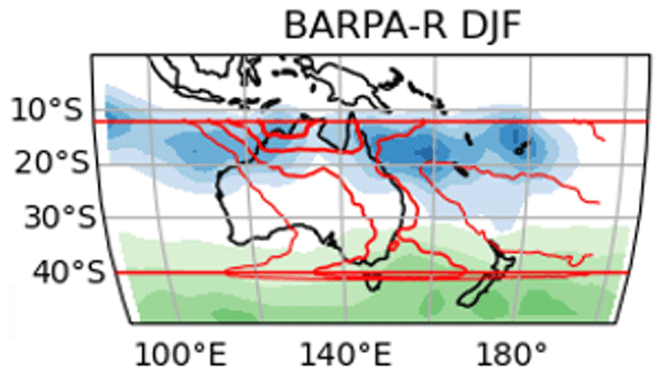
Emma Howard, Chun-Hsu Su, Christian Stassen, Rajashree Naha, Harvey Ye, Acacia Pepler, Samuel S. Bell, Andrew J. Dowdy, Simon O. Tucker, and Charmaine Franklin
Geosci. Model Dev., 17, 731–757, https://doi.org/10.5194/gmd-17-731-2024, https://doi.org/10.5194/gmd-17-731-2024, 2024
Short summary
Short summary
The BARPA-R modelling configuration has been developed to produce high-resolution climate hazard projections within the Australian region. When using boundary driving data from quasi-observed historical conditions, BARPA-R shows good performance with errors generally on par with reanalysis products. BARPA-R also captures trends, known modes of climate variability, large-scale weather processes, and multivariate relationships.
Yuhang Zhang, Aizhong Ye, Bita Analui, Phu Nguyen, Soroosh Sorooshian, Kuolin Hsu, and Yuxuan Wang
Hydrol. Earth Syst. Sci., 27, 4529–4550, https://doi.org/10.5194/hess-27-4529-2023, https://doi.org/10.5194/hess-27-4529-2023, 2023
Short summary
Short summary
Our study shows that while the quantile regression forest (QRF) and countable mixtures of asymmetric Laplacians long short-term memory (CMAL-LSTM) models demonstrate similar proficiency in multipoint probabilistic predictions, QRF excels in smaller watersheds and CMAL-LSTM in larger ones. CMAL-LSTM performs better in single-point deterministic predictions, whereas QRF model is more efficient overall.

Yuan Li, Kangning Xü, Zhiyong Wu, Zhiwei Zhu, and Quan J. Wang
Hydrol. Earth Syst. Sci., 27, 4187–4203, https://doi.org/10.5194/hess-27-4187-2023, https://doi.org/10.5194/hess-27-4187-2023, 2023
Short summary
Short summary
A spatial–temporal projection-based calibration, bridging, and merging (STP-CBaM) method is proposed. The calibration model is built by post-processing ECMWF raw forecasts, while the bridging models are built using atmospheric intraseasonal signals as predictors. The calibration model and bridging models are merged through a Bayesian modelling averaging (BMA) method. The results indicate that the newly developed method can generate skilful and reliable sub-seasonal precipitation forecasts.
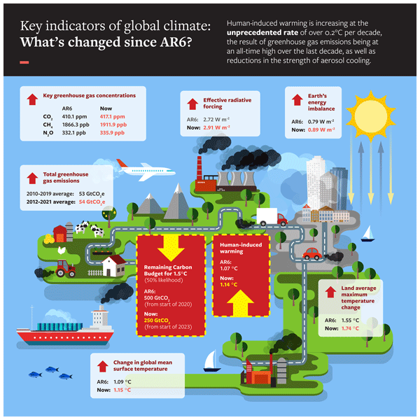
Piers M. Forster, Christopher J. Smith, Tristram Walsh, William F. Lamb, Robin Lamboll, Mathias Hauser, Aurélien Ribes, Debbie Rosen, Nathan Gillett, Matthew D. Palmer, Joeri Rogelj, Karina von Schuckmann, Sonia I. Seneviratne, Blair Trewin, Xuebin Zhang, Myles Allen, Robbie Andrew, Arlene Birt, Alex Borger, Tim Boyer, Jiddu A. Broersma, Lijing Cheng, Frank Dentener, Pierre Friedlingstein, José M. Gutiérrez, Johannes Gütschow, Bradley Hall, Masayoshi Ishii, Stuart Jenkins, Xin Lan, June-Yi Lee, Colin Morice, Christopher Kadow, John Kennedy, Rachel Killick, Jan C. Minx, Vaishali Naik, Glen P. Peters, Anna Pirani, Julia Pongratz, Carl-Friedrich Schleussner, Sophie Szopa, Peter Thorne, Robert Rohde, Maisa Rojas Corradi, Dominik Schumacher, Russell Vose, Kirsten Zickfeld, Valérie Masson-Delmotte, and Panmao Zhai
Earth Syst. Sci. Data, 15, 2295–2327, https://doi.org/10.5194/essd-15-2295-2023, https://doi.org/10.5194/essd-15-2295-2023, 2023
Short summary
Short summary
This is a critical decade for climate action, but there is no annual tracking of the level of human-induced warming. We build on the Intergovernmental Panel on Climate Change assessment reports that are authoritative but published infrequently to create a set of key global climate indicators that can be tracked through time. Our hope is that this becomes an important annual publication that policymakers, media, scientists and the public can refer to.
Keirnan Fowler, Murray Peel, Margarita Saft, Tim J. Peterson, Andrew Western, Lawrence Band, Cuan Petheram, Sandra Dharmadi, Kim Seong Tan, Lu Zhang, Patrick Lane, Anthony Kiem, Lucy Marshall, Anne Griebel, Belinda E. Medlyn, Dongryeol Ryu, Giancarlo Bonotto, Conrad Wasko, Anna Ukkola, Clare Stephens, Andrew Frost, Hansini Gardiya Weligamage, Patricia Saco, Hongxing Zheng, Francis Chiew, Edoardo Daly, Glen Walker, R. Willem Vervoort, Justin Hughes, Luca Trotter, Brad Neal, Ian Cartwright, and Rory Nathan
Hydrol. Earth Syst. Sci., 26, 6073–6120, https://doi.org/10.5194/hess-26-6073-2022, https://doi.org/10.5194/hess-26-6073-2022, 2022
Short summary
Short summary
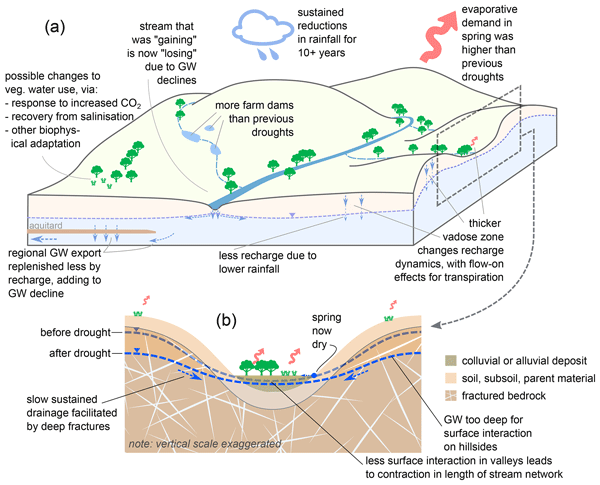
Recently, we have seen multi-year droughts tending to cause shifts in the relationship between rainfall and streamflow. In shifted catchments that have not recovered, an average rainfall year produces less streamflow today than it did pre-drought. We take a multi-disciplinary approach to understand why these shifts occur, focusing on Australia's over-10-year Millennium Drought. We evaluate multiple hypotheses against evidence, with particular focus on the key role of groundwater processes.
Qichun Yang, Quan J. Wang, Andrew W. Western, Wenyan Wu, Yawen Shao, and Kirsti Hakala
Hydrol. Earth Syst. Sci., 26, 941–954, https://doi.org/10.5194/hess-26-941-2022, https://doi.org/10.5194/hess-26-941-2022, 2022
Short summary
Short summary
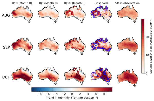
Forecasts of evaporative water loss in the future are highly valuable for water resource management. These forecasts are often produced using the outputs of climate models. We developed an innovative method to correct errors in these forecasts, particularly the errors caused by deficiencies of climate models in modeling the changing climate. We apply this method to seasonal forecasts of evaporative water loss across Australia and achieve significant improvements in the forecast quality.
Cited articles
Acharya, S. C., Nathan, R., Wang, Q. J., and Su, C.-H.: Temporal disaggregation of daily rainfall measurements using regional reanalysis for hydrological applications, J. Hydrol., 610, 127867, https://doi.org/10.1016/j.jhydrol.2022.127867, 2022.
Bari, M., Hasan, M., Evans, A., Frost, A., and Chua, Z.-W.: Development of operational 0.01-degree resolution gridded historical daily precipitation data for Australia, Journal of Southern Hemisphere Earth Systems Science, ES25008, https://doi.org/10.1071/ES25008, 2026.
Beck, H. E., van Dijk, A. I. J. M., Levizzani, V., Schellekens, J., Miralles, D. G., Martens, B., and de Roo, A.: MSWEP: 3-hourly 0.25° global gridded precipitation (1979–2015) by merging gauge, satellite, and reanalysis data, Hydrol. Earth Syst. Sci., 21, 589–615, https://doi.org/10.5194/hess-21-589-2017, 2017.
Beck, H. E., Wood, E. F., Pan, M., Fisher, C. K., Miralles, D. G., van Dijk, A. I. J. M., McVicar, T. R., and Adler, R. F.: MSWEP V2 Global 3-Hourly 0.1° Precipitation: Methodology and Quantitative Assessment, B. Am. Meteorol. Soc., 100, 473–500, https://doi.org/10.1175/BAMS-D-17-0138.1, 2019.
Bergman, K. H.: Role of Observational Errors in Optimum Interpolation Analysis, B. Am. Meteorol. Soc., 59, 1603–1611, https://doi.org/10.1175/1520-0477-59.12.1603, 1978.
Bhargava, M. and Danard, M.: Application of Optimum Interpolation to the Analysis of Precipitation in Complex Terrain, J. Appl. Meteorol. Clim., 33, 508–518, https://doi.org/10.1175/1520-0450(1994)033<0508:AOOITT>2.0.CO;2, 1994.
Bohnenstengel, S. I., Schlünzen, K. H., and Beyrich, F.: Representativity of in situ precipitation measurements – A case study for the LITFASS area in North-Eastern Germany, J. Hydrol., 400, 387–395, https://doi.org/10.1016/j.jhydrol.2011.01.052, 2011.
Bureau of Meteorology: AURA – Operational Radar Network Archive, National Computational Infrastructure [data set], https://doi.org/10.25914/5cb686a8d9450, 2022.
Bureau of Meteorology: Himawari 8/9 – Convective Rain Rate – Physically Based (CRRPH) (V2.1) [data set], National Computational Infrastructure [data set], https://doi.org/10.25914/qc2q-mx21, 2024.
Bureau of Meteorology: Australia Rainfall and River Conditions, Bureau of Meteorology, Australian Government, https://www.bom.gov.au/australia/flood/, last access: 20 February 2025.
Chappell, A., Renzullo, L. J., Raupach, T. H., and Haylock, M.: Evaluating geostatistical methods of blending satellite and gauge data to estimate near real-time daily rainfall for Australia, J. Hydrol., 493, 105–114, https://doi.org/10.1016/j.jhydrol.2013.04.024, 2013.
Chen, H., Wen, D., Du, Y., Xiong, L., and Wang, L.: Errors of five satellite precipitation products for different rainfall intensities, Atmos. Res., 285, 106622, https://doi.org/10.1016/j.atmosres.2023.106622, 2023.
Chua, Z.-W., Kuleshov, Y., Watkins, A. B., Choy, S., and Sun, C.: A Two-Step Approach to Blending GSMaP Satellite Rainfall Estimates with Gauge Observations over Australia, Remote Sens., 14, 1903, https://doi.org/10.3390/rs14081903, 2022a.
Chua, Z.-W., Evans, A., Kuleshov, Y., Watkins, A., Choy, S., and Sun, C.: Enhancing the Australian Gridded Climate Dataset rainfall analysis using satellite data, Sci. Rep., 12, 20691, https://doi.org/10.1038/s41598-022-25255-6, 2022b.
Chua, Z.-W., Kuleshov, Y., Watkins, A. B., Choy, S., and Sun, C.: A Statistical Interpolation of Satellite Data with Rain Gauge Data over Papua New Guinea, J. Hydrometeorol., 24, 2369–2387, https://doi.org/10.1175/JHM-D-23-0035.1, 2023.
Chumchean, S., Seed, A., and Sharma, A.: Correcting of real-time radar rainfall bias using a Kalman filtering approach, J. Hydrol., 317, 123–137, https://doi.org/10.1016/j.jhydrol.2005.05.013, 2006.
Ciach, G. J.: Local Random Errors in Tipping-Bucket Rain Gauge Measurements, J. Atmos. Ocean. Tech., 20, 752–759, https://doi.org/10.1175/1520-0426(2003)20<752:LREITB>2.0.CO;2, 2003.
Delrieu, G., Hucke, L., and Creutin, J. D.: Attenuation in Rain for X- and C-Band Weather Radar Systems: Sensitivity with respect to the Drop Size Distribution, J. Appl. Meteorol. Clim., 38, 57–68, https://doi.org/10.1175/1520-0450(1999)038<0057:AIRFXA>2.0.CO;2, 1999.
De Mey, P.: Optimal Interpolation in a model of the Azores Current in 1986–88, in: Data Assimilation: Tools for Modelling the Ocean in a Global Change Perspective, edited by: Brasseur, P. P. and Nihoul, J. C. J., Springer-Verlag, Berlin, Heidelberg, 85–105, https://doi.org/10.1007/978-3-642-78939-7_4, 1994.
Dong, J., Crow, W. T., Chen, X., Tangdamrongsub, N., Gao, M., Sun, S., Qiu, J., Wei, L., Gao, H., and Duan, Z.: Statistical uncertainty analysis-based precipitation merging (SUPER): A new framework for improved global precipitation estimation, Remote Sens. Environ., 283, 113299, https://doi.org/10.1016/j.rse.2022.113299, 2022.
Dunn, R. E., Fowler, H. J., Green, A. C., and Lewis, E.: Tipping-bucket rain gauges: a review of the undercatch phenomenon, and methods for its reduction and correction, Weather, 80, 196–205, https://doi.org/10.1002/wea.7736, 2025.
Evans, A., Jones, D., Smalley, R., and Lellyett, S.: An enhanced gridded rainfall analysis scheme for Australia, Bureau Research Report No. 041, Bureau of Meteorology, Melbourne, Australia, https://nla.gov.au/nla.obj-2786078795 (last access: 9 October 2026), 2020.
Fortin, V., Roy, G., Donaldson, N., and Mahidjiba, A.: Assimilation of radar quantitative precipitation estimations in the Canadian Precipitation Analysis (CaPA), J. Hydrol., 531, 296–307, https://doi.org/10.1016/j.jhydrol.2015.08.003, 2015.
Fortin, V., Roy, G., Stadnyk, T., Koenig, K., Gasset, N., and Mahidjiba, A.: Ten Years of Science Based on the Canadian Precipitation Analysis: A CaPA System Overview and Literature Review, Atmos.-Ocean, 56, 178–196, https://doi.org/10.1080/07055900.2018.1474728, 2018.
Gandin, L. S.: Objective Analysis of Meteorological Fields, translated from Russian, Israel Program for Scientific Translations, Jerusalem, 242 pp., https://archive.org/details/objectiveanalysi0000lsga (last access: 13 October 2026), 1965.
Gauthier, P., Tanguay, M., Laroche, S., Pellerin, S., and Morneau, J.: Extension of 3DVAR to 4DVAR: Implementation of 4DVAR at the Meteorological Service of Canada, Mon. Weather Rev., 135, 2339–2354, https://doi.org/10.1175/MWR3394.1, 2007.
Gavahi, K., Foroumandi, E., and Moradkhani, H.: A deep learning-based framework for multi-source precipitation fusion, Remote Sens. Environ., 295, 113723, https://doi.org/10.1016/j.rse.2023.113723, 2023.
Huang, X.-Y., Gustafsson, N., and Källén, E. R.: Using an adjoint model to improve an optimum interpolation-based data-assimilation system, Tellus A, 49, 161–176, https://doi.org/10.3402/tellusa.v49i2.14461, 1997.
Hubbert, J. C., Dixon, M., Ellis, S. M., and Meymaris, G.: Weather Radar Ground Clutter. Part I: Identification, Modeling, and Simulation, J. Atmos. Ocean. Tech., 26, 1165–1180, https://doi.org/10.1175/2009JTECHA1159.1, 2009a.
Hubbert, J. C., Dixon, M., and Ellis, S. M.: Weather Radar Ground Clutter. Part II: Real-Time Identification and Filtering, J. Atmos. Oceanic Tech., 26, 1181–1197, https://doi.org/10.1175/2009JTECHA1160.1, 2009b.
Hyfte, S. V., Moigne, P. L., Bazile, E., Verrelle, A., and Boone, A.: High-Resolution Reanalysis of Daily Precipitation using AROME Model Over France, Tellus A, 75, 27–49, https://doi.org/10.16993/tellusa.95, 2023.
Imhoff, R. O., De Cruz, L., Dewettinck, W., Brauer, C. C., Uijlenhoet, R., van Heeringen, K.-J., Velasco-Forero, C., Nerini, D., Van Ginderachter, M., and Weerts, A. H.: Scale-dependent blending of ensemble rainfall nowcasts and numerical weather prediction in the open-source pysteps library, Q. J. Roy. Meteor. Soc., 149, 1335–1364, https://doi.org/10.1002/qj.4461, 2023.
Islam, Md. A., Yu, B., and Cartwright, N.: Assessment and comparison of five satellite precipitation products in Australia, J. Hydrol., 590, 125474, https://doi.org/10.1016/j.jhydrol.2020.125474, 2020.
Jeffrey, S. J., Carter, J. O., Moodie, K. B., and Beswick, A. R.: Using spatial interpolation to construct a comprehensive archive of Australian climate data, Environ. Model. Softw., 16, 309–330, https://doi.org/10.1016/S1364-8152(01)00008-1, 2001.
Jones, D., Wang, W., and Fawcett, R.: High-quality spatial climate data-sets for Australia, Austr. Meteorol. Oceanogr. J., 58, 233–248, https://doi.org/10.22499/2.5804.003, 2009.
Karagiannidis, A., Lahuerta, J. A., Calbet, X., Lliso, L., Lagouvardos, K., Kotroni, V., and Ripodas, P.: Efficiency of the NWC SAF Version 2021 CRRPh Precipitation Product: Comparison against Previous NWC SAF Precipitation Products and the Influence of Topography, Climate, 11, 34, https://doi.org/10.3390/cli11020034, 2023.
Khedhaouiria, D., Bélair, S., Fortin, V., Roy, G., and Lespinas, F.: High-Resolution (2.5 km) Ensemble Precipitation Analysis across Canada, J. Hydrometeorol., 21, 2023–2039, https://doi.org/10.1175/JHM-D-19-0282.1, 2020.
Khedhaouiria, D., Bélair, S., Fortin, V., Roy, G., and Lespinas, F.: Using a hybrid optimal interpolation–ensemble Kalman filter for the Canadian Precipitation Analysis, Nonlin. Processes Geophys., 29, 329–344, https://doi.org/10.5194/npg-29-329-2022, 2022.
Kirsch, B., Clemens, M., and Ament, F.: Stratiform and Convective Radar Reflectivity–Rain Rate Relationships and Their Potential to Improve Radar Rainfall Estimates, J. Appl. Meteorol. Clim., 58, 2259–2271, https://doi.org/10.1175/JAMC-D-19-0077.1, 2019.
Kossieris, P., Tsoukalas, I., Brocca, L., Mosaffa, H., Makropoulos, C., and Anghelea, A.: Precipitation data merging via machine learning: Revisiting conceptual and technical aspects, J. Hydrol., 637, 131424, https://doi.org/10.1016/j.jhydrol.2024.131424, 2024.
Koster, R. D., Liu, Q., Reichle, R. H., and Huffman, G. J.: Improved Estimates of Pentad Precipitation Through the Merging of Independent Precipitation Data Sets, Water Resour. Res. , 57, e2021WR030330, https://doi.org/10.1029/2021WR030330, 2021.
Li, Y., Han, B., Chen, L., Zhou, R., and Li, R.: Refine the Uncertainty of GPM IMERG Precipitation Product Accounting for the Inherent Error From Rain Gauges Estimations, Earth Space Sci., 13, e2025EA004745, https://doi.org/10.1029/2025EA004745, 2026.
Lorenc, A. C., Bell, R. S., and Macpherson, B.: The Meteorological Office analysis correction data assimilation scheme, Q. J. Roy. Meteor. Soc., 117, 59–89, https://doi.org/10.1002/qj.49711749704, 1991.
Ma, Z., Xu, J., Dong, B., Hu, X., Hu, H., Yan, S., Zhu, S., He, K., Shi, Z., Chen, Y., Fang, X., Zhang, Q., Gu, S., and Weng, F.: GMCP: A Fully Global Multisource Merging-and-Calibration Precipitation Dataset (1-Hourly, 0.1°, Global, 2000–the Present), B. Am. Meteorol. Soc., 106, E596–E624, https://doi.org/10.1175/BAMS-D-24-0051.1, 2025.
Mahfouf, J., Brasnett, B., and Gagnon, S.: A Canadian precipitation analysis (CaPA) project: Description and preliminary results, Atmos.-Ocean, 45, 1–17, https://doi.org/10.3137/ao.v450101, 2007.
Malone, T.: Using URBS for Real Time Flood Modelling, in: Water 99 Joint Congress: 25th Hydrology & Water Resources Symposium and 2nd International Conference on Water Resources & Environment Research, Brisbane, Australia, 6–8 July 1999, Institution of Engineers, Australia, Barton, ACT, 603–608, https://search.informit.org/doi/10.3316/informit.705872257387556 (last access: 13 October 2026), 1999.
Malone, T. and Carroll, D.: Guidelines for URBS routing parameters, in: 40th Hydrology & Water Resources Symposium 2022 (HWRS 2022): The Past, the Present, the Future, Brisbane, Australia, 30 November–2 December 2022, Engineers Australia, 145–155, https://search.informit.org/doi/10.3316/informit.905985293458115 (last access: 13 October 2026), 2022.
Martinaitis, S. M., Osborne, A. P., Simpson, M. J., Zhang, J., Howard, K. W., Cocks, S. B., Arthur, A., Langston, C., and Kaney, B. T.: A Physically Based Multisensor Quantitative Precipitation Estimation Approach for Gap-Filling Radar Coverage, J. Hydrometeorol., 21, 1485–1511, https://doi.org/10.1175/JHM-D-19-0264.1, 2020.
McRoberts, D. B. and Nielsen-Gammon, J. W.: Detecting Beam Blockage in Radar-Based Precipitation Estimates, J. Atmos. Ocean. Tech., 34, 1407–1422, https://doi.org/10.1175/JTECH-D-16-0174.1, 2017.
Mitchell, H. L., Charette, C., Chouinard, C., and Brasnett, B.: Revised Interpolation Statistics for the Canadian Data Assimilation Procedure: Their Derivation and Application, Mon. Weather Rev., 118, 1591–1614, https://doi.org/10.1175/1520-0493(1990)118<1591:RISFTC>2.0.CO;2, 1990.
Nguyen, C., Vaze, J., Mateo, C. M. R., Hutchinson, M. F., and Teng, J.: Elevation dependent spatial interpolation of hourly rainfall for accurate flood inundation modelling, Hydrol. Earth Syst. Sci., 30, 45–66, https://doi.org/10.5194/hess-30-45-2026, 2026.
Nishant, N., Sherwood, S., Prasad, A., Ji, F., and Singh, A.: Impact of Higher Spatial Resolution on Precipitation Properties Over Australia, Geophys. Res. Lett., 49, e2022GL100717, https://doi.org/10.1029/2022GL100717, 2022.
Ochoa-Rodriguez, S., Wang, L.-P., Willems, P., and Onof, C.: A Review of Radar-Rain Gauge Data Merging Methods and Their Potential for Urban Hydrological Applications, Water Resour. Res., 55, 6356–6391, https://doi.org/10.1029/2018WR023332, 2019.
Prein, A. F., Rasmussen, R. M., Ikeda, K., Liu, C., Clark, M. P., and Holland, G. J.: The future intensification of hourly precipitation extremes, Nat. Clim. Change, 7, 48–52, https://doi.org/10.1038/nclimate3168, 2017.
Rabier, F.: Overview of global data assimilation developments in numerical weather-prediction centres, Q. J. Roy. Meteor. Soc., 131, 3215–3233, https://doi.org/10.1256/qj.05.129, 2005.
Rabier, F., Järvinen, H., Klinker, E., Mahfouf, J.-F., and Simmons, A.: The ECMWF operational implementation of four-dimensional variational assimilation. I: Experimental results with simplified physics, Q. J. Roy. Meteor. Soc., 126, 1143–1170, https://doi.org/10.1002/qj.49712656415, 2000.
Rawlins, F., Ballard, S. P., Bovis, K. J., Clayton, A. M., Li, D., Inverarity, G. W., Lorenc, A. C., and Payne, T. J.: The Met Office global four-dimensional variational data assimilation scheme, Q. J. Roy. Meteor. Soc., 133, 347–362, https://doi.org/10.1002/qj.32, 2007.
Renzullo, L. J., Velasco-Forero, C. A., and Seed, A. W.: Blending radar, NWP and satellite data for real-time ensemble rainfall analysis: a scale-dependent method, CSIRO, Technical Report EP174236, https://doi.org/10.4225/08/594eb78c96025, 2017.
Seed, A., Duthie, E., and Chumchean, S.: Rainfields: the Australian Bureau of Meteorology system for quantitative precipitation estimation, in: Proceedings 33rd AMS Conference on Radar Meteorology, Cairns, Australia, 6–10 August 2007, American Meteorological Society, https://ams.confex.com/ams/33Radar/techprogram/paper_123340.htm (last access: 9 October 2026), 2007.
Segovia-Cardozo, D. A., Bernal-Basurco, C., and Rodríguez-Sinobas, L.: Tipping Bucket Rain Gauges in Hydrological Research: Summary on Measurement Uncertainties, Calibration, and Error Reduction Strategies, Sensors, 23, 5385, https://doi.org/10.3390/s23125385, 2023.
Seo, B.-C. and Krajewski, W. F.: Investigation of the scale-dependent variability of radar-rainfall and rain gauge error covariance, Adv. Water Resour., 34, 152–163, https://doi.org/10.1016/j.advwatres.2010.10.006, 2011.
Shen, Y., Zhao, P., Pan, Y., and Yu, J.: A high spatiotemporal gauge-satellite merged precipitation analysis over China, J. Geophys. Res.-Atmos., 119, 3063–3075, https://doi.org/10.1002/2013JD020686, 2014.
Shen, Y., Hong, Z., Pan, Y., Yu, J., and Maguire, L.: China's 1 km Merged Gauge, Radar and Satellite Experimental Precipitation Dataset, Remote Sens., 10, 264, https://doi.org/10.3390/rs10020264, 2018.
So, D. and Shin, D.-B.: Classification of precipitating clouds using satellite infrared observations and its implications for rainfall estimation, Q. J. Roy. Meteor. Soc., 144, 133–144, https://doi.org/10.1002/qj.3288, 2018.
Su, C.-H., Eizenberg, N., Steinle, P., Jakob, D., Fox-Hughes, P., White, C. J., Rennie, S., Franklin, C., Dharssi, I., and Zhu, H.: BARRA v1.0: the Bureau of Meteorology Atmospheric high-resolution Regional Reanalysis for Australia, Geosci. Model Dev., 12, 2049–2068, https://doi.org/10.5194/gmd-12-2049-2019, 2019.
Su, C.-H., Eizenberg, N., Jakob, D., Fox-Hughes, P., Steinle, P., White, C. J., and Franklin, C.: BARRA v1.0: kilometre-scale downscaling of an Australian regional atmospheric reanalysis over four midlatitude domains, Geosci. Model Dev., 14, 4357–4378, https://doi.org/10.5194/gmd-14-4357-2021, 2021.
Su, C.-H., Torrance, J., Rennie, S., Howard, E., Stassen, C., Warren, R., Smith, A., Dharssi, I., Pepler, A., Tian, S., Lipson, M., Steinle, P., Franklin, C., Le, T., Wang, C., Masoumi, S., and Le Marshall, J.: The Australian regional atmospheric reanalysis system, version 2 – BARRA2, Journal of Southern Hemisphere Earth Systems Science, 75, ES25032, https://doi.org/10.1071/ES25032, 2025.
Sun, Q., Miao, C., Duan, Q., Ashouri, H., Sorooshian, S., and Hsu, K.: A Review of Global Precipitation Data Sets: Data Sources, Estimation, and Intercomparisons, Rev. Geophys., 56, 79–107, https://doi.org/10.1002/2017RG000574, 2018.
Tang, G., Behrangi, A., Long, D., Li, C., and Hong, Y.: Accounting for spatiotemporal errors of gauges: A critical step to evaluate gridded precipitation products, J. Hydrol., 559, 294–306, https://doi.org/10.1016/j.jhydrol.2018.02.057, 2018.
Upadhyaya, S. A., Kirstetter, P.-E., Gourley, J. J., and Kuligowski, R. J.: On the Propagation of Satellite Precipitation Estimation Errors: From Passive Microwave to Infrared Estimates, J. Hydrometeorol., 21, 1367–1381, https://doi.org/10.1175/JHM-D-19-0293.1, 2020.
Villarini, G., Mandapaka, P. V., Krajewski, W. F., and Moore, R. J.: Rainfall and sampling uncertainties: A rain gauge perspective, J. Geophys. Res.-Atmos., 113, D11102, https://doi.org/10.1029/2007JD009214, 2008.
Xia, H. and Wang, K.: Hourly, kilometer-scale precipitation merged from rain gauge, ground-based radar and satellites over east Asia: methods, evaluation and applications, J. Hydrol., 662, 134148, https://doi.org/10.1016/j.jhydrol.2025.134148, 2025.
Xie, P. and Xiong, A.-Y.: A conceptual model for constructing high-resolution gauge-satellite merged precipitation analyses, J. Geophys. Res.-Atmos., 116, D21106, https://doi.org/10.1029/2011JD016118, 2011.
Xie, P., Chen, M., and Shi, W.: CPC unified gauge-based analysis of global daily precipitation, in: 24th Conference on Hydrology, Atlanta, GA, USA, 18 January 2010, American Meteorological Society, presentation 2.3A, https://ams.confex.com/ams/90annual/webprogram/Paper163676.html (last access: 9 October 2026), 2010.
Xu, L., Chen, N., Moradkhani, H., Zhang, X., and Hu, C.: Improving Global Monthly and Daily Precipitation Estimation by Fusing Gauge Observations, Remote Sensing, and Reanalysis Data Sets, Water Resour. Res., 56, e2019WR026444, https://doi.org/10.1029/2019WR026444, 2020.
Xu, Y., Tang, G., Li, L., and Wan, W.: Multi-source precipitation estimation using machine learning: Clarification and benchmarking, J. Hydrol., 635, 131195, https://doi.org/10.1016/j.jhydrol.2024.131195, 2024.
Yin, J., Guo, S., Gu, L., Zeng, Z., Liu, D., Chen, J., Shen, Y., and Xu, C.-Y.: Blending multi-satellite, atmospheric reanalysis and gauge precipitation products to facilitate hydrological modelling, J. Hydrol., 593, 125878, https://doi.org/10.1016/j.jhydrol.2020.125878, 2021.
Yu, J., Li, X.-F., Lewis, E., Blenkinsop, S., and Fowler, H. J.: UKGrsHP: a UK high-resolution gauge–radar–satellite merged hourly precipitation analysis dataset, Clim. Dynam., 54, 2919–2940, https://doi.org/10.1007/s00382-020-05144-2, 2020.
Zhang, W., Furtado, K., Wu, P., Zhou, T., Chadwick, R., Marzin, C., Rostron, J., and Sexton, D.: Increasing precipitation variability on daily-to-multiyear time scales in a warmer world, Sci. Adv., 7, eabf8021, https://doi.org/10.1126/sciadv.abf8021, 2021a.
Zhang, Y., Ye, A., Nguyen, P., Analui, B., Sorooshian, S., and Hsu, K.: Error Characteristics and Scale Dependence of Current Satellite Precipitation Estimates Products in Hydrological Modeling, Remote Sens., 13, 3061, https://doi.org/10.3390/rs13163061, 2021b.
Zhang, Y., Ye, A., Nguyen, P., Analui, B., Sorooshian, S., and Hsu, K.: New Insights Into Error Decomposition for Precipitation Products, Geophys. Res. Lett., 48, e2021GL094092, https://doi.org/10.1029/2021GL094092, 2021c.
Zhang, Y., Wang, Q. J., Frost, A. J., Trewin, B., Pudashine, J., Velasco-Forero, C., Su, C.-H., and Villani, V.: Advancing High-Resolution Precipitation Analysis for Operational Hydrological Applications in Australia: Data Sources, Methodologies, and Recommendations, WIREs Water, 12, e70037, https://doi.org/10.1002/wat2.70037, 2025.
Zhang, Y., Wang, Q. J., Frost, A. J., Pudashine, J., Trewin, B., Velasco-Forero, C., Su, C.-H., and Villani, V.: A localisation strategy for scalable and efficient multi-source precipitation blending at high resolutions over large domains, J. Hydrol., 677, 135831, https://doi.org/10.1016/j.jhydrol.2026.135831, 2026.
Zhang, Y., Wang, Q. J., Frost, A. J., Pudashine, J., Trewin, B., Velasco-Forero, C., Su, C.-H., Hasan, M. M., and Villani, V.: When radar and hourly gauges are scarce: Sharpening gridded precipitation estimates using daily observations, Atmos. Res., 345, 109368, https://doi.org/10.1016/j.atmosres.2026.109368, 2027.
Zhu, S., Tang, G., Sorooshian, S., Huffman, G. J., Duan, Q., Yan, S., Behrangi, A., Papalexiou, S. M., Nguyen, P., Hsu, K., Wen, Y., Liu, Z., Li, Z., Chen, M., Laviola, S., and Hong, Y.: A Review of the Past Half Century of Geostationary Satellite Thermal Observations for Global Precipitation Estimation: Developments, achievements, and future prospects, IEEE Geosci. Remote Sens. Mag., 14, 369–391, https://doi.org/10.1109/MGRS.2026.3665828, 2026.
Short summary
This study develops and tests a new system that combines satellite, radar, and rain gauge measurements to produce hourly rainfall maps at 2 km resolution across Australia. The results show improved rainfall estimates and better representation of local rainfall patterns compared with existing products. The system can support real-time rainfall monitoring and reconstruction of historical rainfall, and provides a practical approach that could also be applied in other regions.
This study develops and tests a new system that combines satellite, radar, and rain gauge...


Altmetrics
Final-revised paper
Preprint