
Articles | Volume 30, issue 13
https://doi.org/10.5194/hess-30-4305-2026
© Author(s) 2026. This work is distributed under
the Creative Commons Attribution 4.0 License.
the Creative Commons Attribution 4.0 License.
https://doi.org/10.5194/hess-30-4305-2026
© Author(s) 2026. This work is distributed under
the Creative Commons Attribution 4.0 License.
the Creative Commons Attribution 4.0 License.
Research article
| 
13 Jul 2026
Research article |
| 13 Jul 2026
| 13 Jul 2026
Forest floor water storage and redistribution affect evaporation, retention, and infiltration in mixed temperate forests
Heinke Paulsen
CORRESPONDING AUTHOR

Chair for Hydrology, Albert Ludwig University, 79098 Freiburg, Germany
Markus Weiler
Chair for Hydrology, Albert Ludwig University, 79098 Freiburg, Germany
Related authors
Heinke Paulsen and Markus Weiler
Hydrol. Earth Syst. Sci., 29, 2309–2319, https://doi.org/10.5194/hess-29-2309-2025, https://doi.org/10.5194/hess-29-2309-2025, 2025
Short summary
Short summary
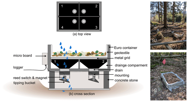
This technical note describes the development of a weighing forest floor grid lysimeter. The device is needed to investigate the dynamics of the water balance components of the organic layer in forests, quantifying precipitation, drainage, evaporation, and storage. We designed a setup that can be easily rebuilt and that is cost-effective, which allows for customized applications. Performance metrics from laboratory results and initial field data are presented.
Lea Dedden and Markus Weiler
EGUsphere, https://doi.org/10.5194/egusphere-2026-4703, https://doi.org/10.5194/egusphere-2026-4703, 2026
This preprint is open for discussion and under review for Hydrology and Earth System Sciences (HESS).
Short summary
Short summary
Using a dense 400 sensor network over 2.5 years, we studied how tree types influence forest soil moisture. We found soil moisture varies largely in space and time. In pure tree plots, the moisture variability peaks during intermediate wetness – when vegetation influence is strongest – but remains low during dry and wet phases. Consistently wet and dry zones indicate that spatial pattern are temporally stable. This work highlights small-scale spatiotemporal variability of forest water fluxes.
Jonas Pyschik, Veronica Cordero, Jakob Wilk, Veronika Lechner, Emanuel Thoenes, Stefan Achleitner, Bernhard Kohl, Markus Weiler, and Stefan Hergarten
EGUsphere, https://doi.org/10.5194/egusphere-2026-4469, https://doi.org/10.5194/egusphere-2026-4469, 2026
This preprint is open for discussion and under review for Hydrology and Earth System Sciences (HESS).
Short summary
Short summary
When it rains, much of the water reaching a stream has been stored in the soil for a long time, but why was unclear. We sprinkled two forested slopes with labelled water and used electrical imaging to watch it move. Only a small share moved quickly to the slope base; most of the outflow was older water pushed out by the pressure of the new rain. Much of the new water stayed in the topsoil and was released weeks later, affecting how soils carry nutrients and pollutants to streams.
Emanuel Thoenes, Theresa Blume, Markus Weiler, Bernhard Kohl, Luisa Hopp, and Stefan Achleitner
Hydrol. Earth Syst. Sci., 30, 4405–4436, https://doi.org/10.5194/hess-30-4405-2026, https://doi.org/10.5194/hess-30-4405-2026, 2026
Short summary
Short summary
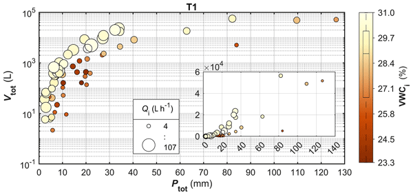
Subsurface stormflow (SSF) is a key runoff mechanism in upland environments. The analysis of SSF at two trenched hillslopes showed that SSF volume was controlled by total rainfall and initial wetness. Peakflow depended on rainfall amount, with initial wetness and rainfall intensity being important for small and large events, respectively. The rate at which SSF increased was linked to rainfall intensity and amount.
Markus Weiler, Julia Krumm, Ingo Haag, Hannes Leistert, Max Schmit, Andreas Steinbrich, and Andreas Hänsler
Nat. Hazards Earth Syst. Sci., 26, 2673–2689, https://doi.org/10.5194/nhess-26-2673-2026, https://doi.org/10.5194/nhess-26-2673-2026, 2026
Short summary
Short summary
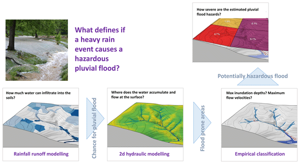
Pluvial (flash) floods, caused by intense local rainfall, result in surface runoff and overland flow, making them different from fluvial floods. A new Pluvial Flood Index (PFI) combines precipitation, hydrological, and hydrodynamic processes to assess surface flooding hazards. The PFI, based on flood hazard areas, helps forecast flash floods and supports real-time warning systems, aiding municipal decision-making, preparedness, and planning.
Lea Dedden and Markus Weiler
Hydrol. Earth Syst. Sci., 30, 3245–3261, https://doi.org/10.5194/hess-30-3245-2026, https://doi.org/10.5194/hess-30-3245-2026, 2026
Short summary
Short summary
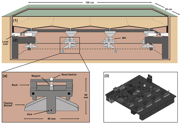
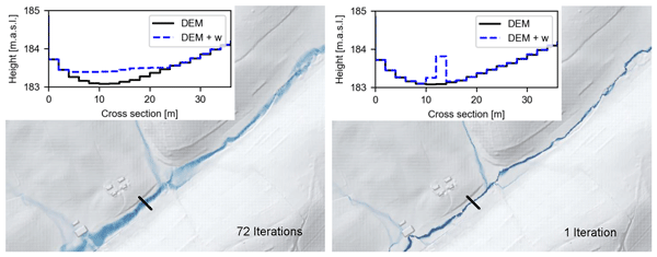
Throughfall in forests varies in space and time creating distinct patterns. We developed a novel throughfall monitoring approach for continuous, automated measurement that features 60 self-built and cost effective throughfall samplers. Collected data show the potential of the approach to capture throughfall variability at small distances, among and within rainfall events and between different trees species.
Hannes Leistert, Andreas Hänsler, Max Schmit, Andreas Steinbrich, and Markus Weiler
Geosci. Model Dev., 19, 2023–2037, https://doi.org/10.5194/gmd-19-2023-2026, https://doi.org/10.5194/gmd-19-2023-2026, 2026
Short summary
Short summary
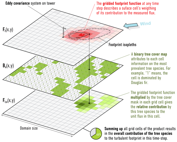
The newly developed model AccRo (Accumulation-based Runoff and Pluvial Flood Estimation Tool) is a computationally efficient method to derive key parameters for estimating pluvial flood hazards. Here, we compare results of AccRo with the data of two hydrodynamic models for different cases. We find that AccRo is able to represent the simulations of the hydrodynamic models in high quality, but with much lower computational effort, making it a valuable tool for assessing pluvial flood hazards.
Hassane Moutahir, Markus Sulzer, Ralf Kiese, Andreas Christen, Markus Weiler, Lea Dedden, Julian Brzozon, Pia Labenski, Prajwal Khanal, Ladislav Šigut, and Rüdiger Grote
Biogeosciences, 23, 1719–1738, https://doi.org/10.5194/bg-23-1719-2026, https://doi.org/10.5194/bg-23-1719-2026, 2026
Short summary
Short summary
Eddy covariance (EC) data are vital for studying carbon and water fluxes but often mask species-specific responses in mixed forests. At a Black Forest site with beech and Douglas fir, we combined EC data with ecosystem modeling to separate species contributions. Results show EC fluxes reflect species abundance within flux footprints, though responses vary seasonally. Accounting for these differences is key for gap-filling, accurate budgets, and understanding mixed forests’ climate resilience.

Sebastian Gnann, Bailey J. Anderson, and Markus Weiler
Hydrol. Earth Syst. Sci., 30, 779–795, https://doi.org/10.5194/hess-30-779-2026, https://doi.org/10.5194/hess-30-779-2026, 2026
Short summary
Short summary
The extent to which streamflow varies in response to variability in precipitation and potential evaporation is essential for understanding climate change impacts on water resources. This so-called streamflow sensitivity is often estimated directly from observational data, but the robustness of these estimates remains unclear. Through systematic examination of existing approaches, we highlight uncertainties inherent in all approaches and discuss their origins.
Jonas Pyschik and Markus Weiler
Hydrol. Earth Syst. Sci., 30, 485–501, https://doi.org/10.5194/hess-30-485-2026, https://doi.org/10.5194/hess-30-485-2026, 2026
Short summary
Short summary
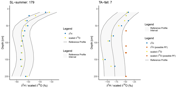
This study introduces a new method of detecting how water moves quickly through certain paths in soil, bypassing the usual, slower flow. By analysing natural water markers in soil samples taken at different depths, we identified unusual flow patterns. Our method is simple and non-invasive, and can be used to cover large areas. This helps us to better understand how water travels through the ground, which is important for managing water resources and protecting the environment.
Jasmin Tesch, Kathrin Kühnhammer, Delon Wagner, Andreas Christen, Carsten Dormann, Julian Frey, Rüdiger Grote, Teja Kattenborn, Markus Sulzer, Ulrike Wallrabe, Markus Weiler, Christiane Werner, Samaneh Baghbani, Julian Brzozon, Laura Maria Comella, Lea Dedden, Stefanie Dumberger, Yasmina Frey, Matthias Gassilloud, Timo Gerach, Anna Göritz, Simon Haberstroh, Johannes Klüppel, Luis Kremer, Jürgen Kreuzwieser, Hojin Lee, Joachim Maack, Julian Müller, Oswald Prucker, Sanam Kumari Rajak, Jürgen Rühe, Stefan J. Rupitsch, Helmer Schack-Kirchner, Christian Scharinger, Uttunga Shinde, Till Steinmann, Clara Stock, and Josef Strack
EGUsphere, https://doi.org/10.5194/egusphere-2025-4979, https://doi.org/10.5194/egusphere-2025-4979, 2025
Short summary
Short summary
In the ECOSENSE forest, we developed a robust infrastructure for distributed forest sensing. Reliable power supply, stable network connection, and smart data collection systems enable the operation of hundreds of sensors under challenging conditions. By detailing the infrastructure design and implementation, we provide a transferable blueprint for building complex monitoring sites that support high-resolution, long-term ecosystem observations.
Theresa Blume, Peter Chifflard, Stefan Achleitner, Andreas Hartmann, Stefan Hergarten, Luisa Hopp, Bernhard Kohl, Florian Leese, Ilja van Meerveld, Christian Reinhardt-Imjela, and Markus Weiler
EGUsphere, https://doi.org/10.5194/egusphere-2025-4424, https://doi.org/10.5194/egusphere-2025-4424, 2025
Short summary
Short summary
Subsurface stormflow (SSF) is one of the least studied and therefore least understood runoff generation processes because detecting and quantifying SSF is extremely challenging. We present an ongoing concerted experimental effort to systematically investigate SSF across four catchments using a variety of methods covering different spatial scales. Centerpiece of this effort is the construction of 12 large trenches to capture and monitor SSF.
Heinke Paulsen and Markus Weiler
Hydrol. Earth Syst. Sci., 29, 2309–2319, https://doi.org/10.5194/hess-29-2309-2025, https://doi.org/10.5194/hess-29-2309-2025, 2025
Short summary
Short summary
This technical note describes the development of a weighing forest floor grid lysimeter. The device is needed to investigate the dynamics of the water balance components of the organic layer in forests, quantifying precipitation, drainage, evaporation, and storage. We designed a setup that can be easily rebuilt and that is cost-effective, which allows for customized applications. Performance metrics from laboratory results and initial field data are presented.
Jonas Pyschik, Stefan Seeger, Barbara Herbstritt, and Markus Weiler
Hydrol. Earth Syst. Sci., 29, 525–534, https://doi.org/10.5194/hess-29-525-2025, https://doi.org/10.5194/hess-29-525-2025, 2025
Short summary
Short summary
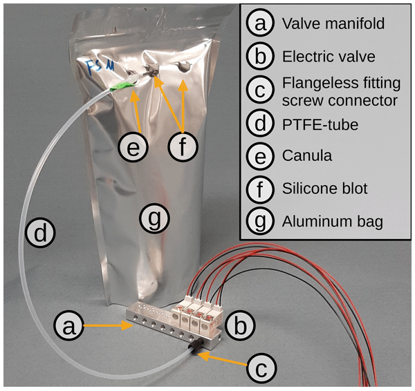
We developed a device (named VapAuSa) that automates stable water isotope analysis. Stable water isotopes are a natural tracer that many researchers use to investigate water (re-)distribution processes in environmental systems. VapAuSa helps to analyse such environmental samples by automating a formerly tedious manual process, allowing for higher sample throughput. This enables larger sampling campaigns, as more samples can be processed before reaching their limited storage time.
Robin Schwemmle, Hannes Leistert, Andreas Steinbrich, and Markus Weiler
Geosci. Model Dev., 17, 5249–5262, https://doi.org/10.5194/gmd-17-5249-2024, https://doi.org/10.5194/gmd-17-5249-2024, 2024
Short summary
Short summary
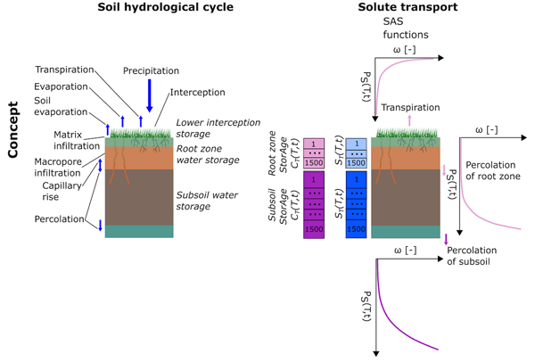
The new process-based hydrological toolbox model, RoGeR (https://roger.readthedocs.io/), can be used to estimate the components of the hydrological cycle and the related travel times of pollutants through parts of the hydrological cycle. These estimations may contribute to effective water resources management. This paper presents the toolbox concept and provides a simple example of providing estimations to water resources management.
Barbara Herbstritt, Benjamin Gralher, Stefan Seeger, Michael Rinderer, and Markus Weiler
Hydrol. Earth Syst. Sci., 27, 3701–3718, https://doi.org/10.5194/hess-27-3701-2023, https://doi.org/10.5194/hess-27-3701-2023, 2023
Short summary
Short summary
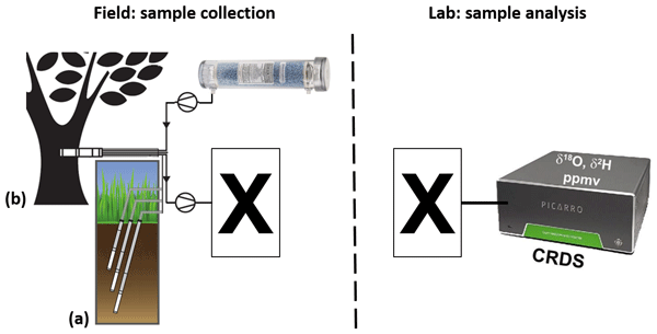
We present a method to collect water vapor samples into bags in the field without an in-field analyser, followed by isotope analysis in the lab. This new method resolves even fine-scaled natural isotope variations. It combines low-cost and lightweight components for maximum spatial and temporal flexibility regarding environmental setups. Hence, it allows for sampling even in terrains that are rather difficult to access, enabling future extended isotope datasets in soil sciences and ecohydrology.
Stefan Seeger and Markus Weiler
Hydrol. Earth Syst. Sci., 27, 3393–3404, https://doi.org/10.5194/hess-27-3393-2023, https://doi.org/10.5194/hess-27-3393-2023, 2023
Short summary
Short summary
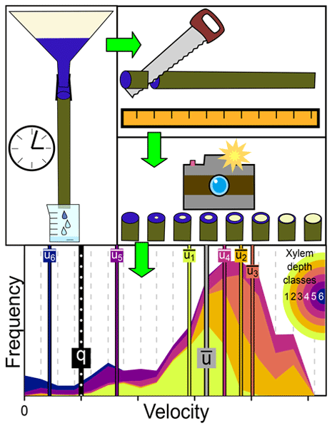
This study proposes a low-budget method to quantify the radial distribution of water transport velocities within trees at a high spatial resolution. We observed a wide spread of water transport velocities within a tree stem section, which were on average 3 times faster than the flux velocity. The distribution of transport velocities has implications for studies that use water isotopic signatures to study root water uptake and usually assume uniform or even implicitly infinite velocities.
Andreas Hänsler and Markus Weiler
Hydrol. Earth Syst. Sci., 26, 5069–5084, https://doi.org/10.5194/hess-26-5069-2022, https://doi.org/10.5194/hess-26-5069-2022, 2022
Short summary
Short summary
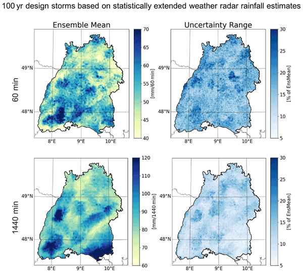
Spatially explicit quantification of design storms is essential for flood risk assessment and planning. However, available datasets are mainly based on spatially interpolated station-based design storms. Since the spatial interpolation of the data inherits a large potential for uncertainty, we develop an approach to be able to derive spatially explicit design storms on the basis of weather radar data. We find that our approach leads to an improved spatial representation of design storms.
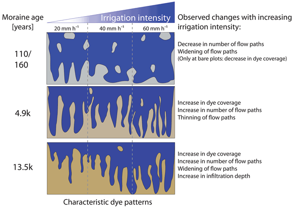
Anne Hartmann, Markus Weiler, Konrad Greinwald, and Theresa Blume
Hydrol. Earth Syst. Sci., 26, 4953–4974, https://doi.org/10.5194/hess-26-4953-2022, https://doi.org/10.5194/hess-26-4953-2022, 2022
Short summary
Short summary
Analyzing the impact of soil age and rainfall intensity on vertical subsurface flow paths in calcareous soils, with a special focus on preferential flow occurrence, shows how water flow paths are linked to the organization of evolving landscapes. The observed increase in preferential flow occurrence with increasing moraine age provides important but rare data for a proper representation of hydrological processes within the feedback cycle of the hydro-pedo-geomorphological system.
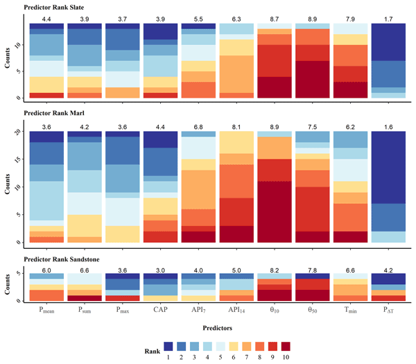
Nils Hinrich Kaplan, Theresa Blume, and Markus Weiler
Hydrol. Earth Syst. Sci., 26, 2671–2696, https://doi.org/10.5194/hess-26-2671-2022, https://doi.org/10.5194/hess-26-2671-2022, 2022
Short summary
Short summary
This study is analyses how characteristics of precipitation events and soil moisture and temperature dynamics during these events can be used to model the associated streamflow responses in intermittent streams. The models are used to identify differences between the dominant controls of streamflow intermittency in three distinct geologies of the Attert catchment, Luxembourg. Overall, soil moisture was found to be the most important control of intermittent streamflow in all geologies.
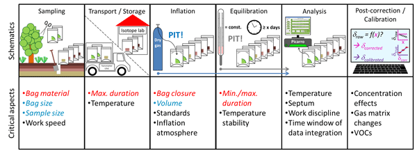
Benjamin Gralher, Barbara Herbstritt, and Markus Weiler
Hydrol. Earth Syst. Sci., 25, 5219–5235, https://doi.org/10.5194/hess-25-5219-2021, https://doi.org/10.5194/hess-25-5219-2021, 2021
Short summary
Short summary
We scrutinized the quickest currently available method for stable isotope analysis of matrix-bound water. Simulating common procedures, we demonstrated the limits of certain materials currently used and identified a reliable and cost-efficient alternative. Further, we calculated the optimum proportions of important protocol aspects critical for precise and accurate analyses. Our unifying protocol suggestions increase data quality and comparability as well as the method's general applicability.
Cited articles
AG Boden: Bodenkundliche Kartieranleitung – Band 1: Grundlagen, Kennwerte und Methoden, 6. edn., Hannover, ISBN 978-3-510-96869-5, 2024.
Beven, K.: A sensitivity analysis of the Penman-Monteith actual evapotranspiration estimates, J. Hydrol., 44, 169–190, https://doi.org/10.1016/0022-1694(79)90130-6, 1979.
Deguchi, A., Hattori, S., and Park, H.-T.: The influence of seasonal changes in canopy structure on interception loss: Application of the revised Gash model, J. Hydrol., 318, 80–102, https://doi.org/10.1016/j.jhydrol.2005.06.005, 2006.
Deguchi, A., Hattori, S., Daikoku, K., and Park, H.: Measurement of evaporation from the forest floor in a deciduous forest throughout the year using microlysimeter and closed-chamber systems, Hydrol. Process., 22, 3712–3723, https://doi.org/10.1002/hyp.6974, 2008.
Dunkerley, D.: Identifying individual rain events from pluviograph records: a review with analysis of data from an Australian dryland site, Hydrol. Process., 22, 5024–5036, https://doi.org/10.1002/hyp.7122, 2008.
Floriancic, M. G., Allen, S. T., Meier, R., Truniger, L., Kirchner, J. W., and Molnar, P.: Potential for significant precipitation cycling by forest-floor litter and deadwood, Ecohydrology, 16, https://doi.org/10.1002/eco.2493, 2023.
Gerrits, A. M. J., Savenije, H. H. G., Hoffmann, L., and Pfister, L.: New technique to measure forest floor interception – an application in a beech forest in Luxembourg, Hydrol. Earth Syst. Sci., 11, 695–701, https://doi.org/10.5194/hess-11-695-2007, 2007.
Gimbel, K. F., Puhlmann, H., and Weiler, M.: Does drought alter hydrological functions in forest soils?, Hydrol. Earth Syst. Sci., 20, 1301–1317, https://doi.org/10.5194/hess-20-1301-2016, 2016.
Greiffenhagen, A., Wessolek, G., Facklam, M., Renger, M., and Stoffregen, H.: Hydraulic functions and water repellency of forest floor horizons on sandy soils, Geoderma, 132, 182–195, https://doi.org/10.1016/j.geoderma.2005.05.006, 2006.
Guevara-Escobar, A., Gonzalez-Sosa, E., Ramos-Salinas, M., and Hernandez-Delgado, G. D.: Experimental analysis of drainage and water storage of litter layers, Hydrol. Earth Syst. Sci., 11, 1703–1716, https://doi.org/10.5194/hess-11-1703-2007, 2007.
Ilek, A., Szostek, M., Mikołajczyk, A., and Rajtar, M.: Does Mixing Tree Species Affect Water Storage Capacity of the Forest Floor? Laboratory Test of Pine-Oak and Fir-Beech Litter Layers, Forests, 12, 1674, https://doi.org/10.3390/f12121674, 2021.
International Union of Soil Sciences (IUSS): World reference base for soil resources 2022: International soil classification system for naming soils and creating legends for soil maps, 4. edn., International Union of Soil Sciences, Vienna, Austria, ISBN 979-8-9862451-1-9, 2022.
Keim, R. F., Skaugset, A. E., and Weiler, M.: Storage of water on vegetation under simulated rainfall of varying intensity, Adv. Water Resour., 29, 974–986, https://doi.org/10.1016/j.advwatres.2005.07.017, 2006.
Levia, D. F., Carlyle-Moses, D., and Tanaka, T. (Eds.): Forest Hydrology and Biogeochemistry: Synthesis of Past Research and Future Directions, Springer Netherlands, Dordrecht, https://doi.org/10.1007/978-94-007-1363-5, 2011.
Li, Q., Lee, Y. E., and Im, S.: Characterizing the Interception Capacity of Floor Litter with Rainfall Simulation Experiments, Water, 12, 3145, https://doi.org/10.3390/w12113145, 2020.
Magliano, P. N., Giménez, R., Houspanossian, J., Páez, R. A., Nosetto, M. D., Fernández, R. J., and Jobbágy, E. G.: Litter is more effective than forest canopy reducing soil evaporation in Dry Chaco rangelands, Ecohydrology, 10, https://doi.org/10.1002/eco.1879, 2017.
Nanko, K., Keim, R. F., Hudson, S. A., and Levia, D. F.: Throughfall drop sizes suggest canopy flowpaths vary by phenophase, J. Hydrol., 612, 128144, https://doi.org/10.1016/j.jhydrol.2022.128144, 2022.
Neris, J., Tejedor, M., Rodríguez, M., Fuentes, J., and Jiménez, C.: Effect of forest floor characteristics on water repellency, infiltration, runoff and soil loss in Andisols of Tenerife (Canary Islands, Spain), CATENA, 108, 50–57, https://doi.org/10.1016/j.catena.2012.04.011, 2013.
Orfánus, T., Zvala, A., Čierniková, M., Stojkovová, D., Nagy, V., and Dlapa, P.: Peculiarities of Infiltration Measurements in Water-Repellent Forest Soil, Forests, 12, 472, https://doi.org/10.3390/f12040472, 2021.
Paulsen, H.: Dataset to go with “Forest floor water storage and redistribution affect evaporation, retention, and infiltration in mixed temperate forests”, FreiData [data set], https://doi.org/10.60493/0apjq-0aa41, 2026.
Paulsen, H. and Weiler, M.: Technical note: A weighing forest floor grid lysimeter, Hydrol. Earth Syst. Sci., 29, 2309–2319, https://doi.org/10.5194/hess-29-2309-2025, 2025.
Pohl, S., Garvelmann, J., Wawerla, J., and Weiler, M.: Potential of a low‐cost sensor network to understand the spatial and temporal dynamics of a mountain snow cover, Water Resour. Res., https://doi.org/10.1002/2013WR014594, 2014.
Putuhena, W. M. and Cordery, I.: Estimation of interception capacity of the forest floor, J. Hydrol., 180, 283–299, https://doi.org/10.1016/0022-1694(95)02883-8, 1996.
Sato, Y., Kumagai, T., Kume, A., Otsuki, K., and Ogawa, S.: Experimental analysis of moisture dynamics of litter layers – the effects of rainfall conditions and leaf shapes, Hydrol. Process., 18, 3007–3018, https://doi.org/10.1002/hyp.5746, 2004.
Van Stan, J. T., Coenders-Gerrits, M., Dibble, M., Bogeholz, P., and Norman, Z.: Effects of phenology and meteorological disturbance on litter rainfall interception for a Pinus elliottii stand in the Southeastern United States, Hydrol. Process., 31, 3719–3728, https://doi.org/10.1002/hyp.11292, 2017.
Vogelmann, E. S., Reichert, J. M., Prevedello, J., Consensa, C. O. B., Oliveira, A. É., Awe, G. O., and Mataix-Solera, J.: Threshold water content beyond which hydrophobic soils become hydrophilic: The role of soil texture and organic matter content, Geoderma, 209–210, 177–187, https://doi.org/10.1016/j.geoderma.2013.06.019, 2013.
Walsh, R. P. D. and Voigt, P. J.: Vegetation Litter: An Underestimated Variable in Hydrology and Geomorphology, J. Biogeogr., 4, 253, https://doi.org/10.2307/3038060, 1977.
Wessolek, G., Schwärzel, K., Greiffenhagen, A., and Stoffregen, H.: Percolation characteristics of a water-repellent sandy forest soil, Eur. J. Soil Sci., 59, 14–23, https://doi.org/10.1111/j.1365-2389.2007.00980.x, 2008.
Zagyvai-Kiss, K. A., Kalicz, P., Szilágyi, J., and Gribovszki, Z.: On the specific water holding capacity of litter for three forest ecosystems in the eastern foothills of the Alps, Agric. For. Meteorol., 278, 107656, https://doi.org/10.1016/j.agrformet.2019.107656, 2019.
Zhao, L., Meng, P., Zhang, J., Zhang, J., Sun, S., and He, C.: Effect of slopes on rainfall interception by leaf litter under simulated rainfall conditions, Hydrol. Process., 36, https://doi.org/10.1002/hyp.14659, 2022.
Short summary
Using 12 Forest floor (FF) lysimeters at three beech‑dominated sites, we recorded 1570 rain events and measured throughfall, drainage, and evaporation. Initial retention depended on pre‑event moisture, not litter thickness. Low‑intensity, long‑duration rains filled the FF more efficiently than brief, intense storms. Evaporation was low and consistent across sites, showing the FF protects the soil. Spatial data revealed frequent water redistribution, creating heterogeneous flow paths.
Using 12 Forest floor (FF) lysimeters at three beech‑dominated sites, we recorded 1570 rain...


