
the Creative Commons Attribution 4.0 License.
the Creative Commons Attribution 4.0 License.
 | 20 Jul 2026
The complex effect of climate change and urbanization on streamflow in small–medium eastern Mediterranean catchments
Yair Rinat
Moshe Armon
Efrat Morin
Future floods in the eastern Mediterranean region are influenced by the dual pressures of accelerated climate change and rapid urbanization. Yet the small spatial scale and complexity of hydrometeorological processes make it difficult to project their joint effects. Intra-basin flood projections, in particular, remain absent. This study examines how these drivers affect peak discharge and flood volume in small to medium-sized eastern Mediterranean basins in Israel, using high-resolution weather and hydrological models. We analyze 32 rainstorms under historical (late 20th century) and future (late 21st century) climate scenarios, incorporating projected urban expansion. Results show that while short-duration and high rain rates increase, accumulated precipitation, rainfall area, storm duration, and soil water storage significantly decrease. The combined effect of changes in rainfall patterns, soil water storage, and urbanization produces contrasting trends: urbanization alone leads to a substantial increase in mean peak discharge (+43 %) and flood volume (+41 %), especially when soil water storage is undersaturated and the influence of impervious surfaces is greatest. Conversely, considering only projected rainfall scenario yields decreases in mean peak discharge (−21 %) and flood volume (−30 %), despite higher rain intensities. However, during extreme events, when soil moisture approaches saturation, flood intensification can occur. Combined climate and urban scenarios demonstrate that urbanization dominates, resulting in increased mean peak discharge (+13 %). The high-resolution modeling reveals substantial intra-basin variability, with peak discharge intensification concentrated in upstream and urbanized areas. These localized and contrasting effects highlight the need for integrated high-resolution modeling and future land-use planning to support effective flood mitigation and water-management strategies.
- Article
(4296 KB) - Full-text XML
-
Supplement
(1211 KB) - BibTeX
- EndNote


Floods are among the most significant natural hazards worldwide, causing substantial casualties and extensive damage to properties and ecosystems (Merz et al., 2021). They also have benefits, particularly in dry and Mediterranean climates, where they contribute to water storage in lakes, reservoirs, and groundwater aquifers (Rieder et al., 2025; Taylor et al., 2013). Understanding how flood peak discharge and volume may change under future conditions is therefore essential for assessing both flood risks and potential water resource gains. This is particularly important in the Mediterranean region, a recognized climate change hotspot, characterized by temperature and drought risk increase, and changes in rainfall patterns (e.g., Giorgi, 2006; Giorgi and Lionello, 2008). At the same time, rapid urban development modifies the hydrological response to rainfall by amplifying runoff (Faccini et al., 2015, 2021; Fletcher et al., 2013). The combined climate change and urbanization pressures increase the region's risk (Noto et al., 2023a) and alter flood properties, such as peak discharge and volume, but to what extent, or even to what direction, remains uncertain (Llasat, 2021).
The Mediterranean region spans 6.3 % of the global land area and is home to over 500 million people (Ali et al., 2022). It is generally characterized by steep topography and a scarcity of large drainage basins (Guth, 2011), and contains numerous small (<10 km2) to medium-sized (10–100 km2) basins (Allam et al., 2020; Merheb et al., 2016). Land use across the region is diverse: approximately 38 % is covered by crop-lands, 56 % by natural landscapes such as forest and uncultivated regions, and rural and urban settlements account for 4.1 % and 1.3 % of the land, respectively (Malek and Verburg, 2017).
The eastern Mediterranean climate is characterized by hot dry summers and mild wet winters. Precipitation is highly seasonal with substantial intra- and inter-annual variability (Goldreich, 2003; Kushnir et al., 2017; Vicente-Serrano et al., 2025). Droughts are frequent (Lionello, 2012), leading to water stress across large parts of the region (Milano et al., 2013). When rainfall does occur, it often results in heavy precipitation events (Armon et al., 2020; Hochman et al., 2022), significantly contributing to the water budget (Nasta et al., 2018; Samuels et al., 2009; Shi et al., 2023; Taylor et al., 2013) but also occasionally leading to severe flash floods, casualties, damage to infrastructure, and economical losses (Armon et al., 2025; Barredo, 2007; Borga et al., 2019; Caldas-Alvarez et al., 2022; Gaume et al., 2016; Paprotny et al., 2018; Rinat et al., 2021; Smith et al., 2013; Tradowsky et al., 2023).
Projected climate trends for the eastern Mediterranean region point toward a significant warming and drying, surpassing global averages (Ali et al., 2022; Lionello and Scarascia, 2018; Seneviratne et al., 2021). The rainy season is expected to shorten, with longer and more frequent dry spells (Hochman et al., 2018; Tabari and Willems, 2018). While annual precipitation is projected to decrease, rainstorms are anticipated to become more localized and intense (e.g., Armon et al., 2022; Donat et al., 2016; Tramblay and Somot, 2018; Zappa et al., 2015). In parallel, potential evapotranspiration is expected to increase, especially in the wet season (Mariotti et al., 2015), leading to reduced soil moisture (e.g., Nielsen et al., 2024). Alongside these climatic shifts, urban areas across the region are projected to expand, driven by population growth (Jiang and O'Neill, 2017; Lana-Renault et al., 2020; Malek et al., 2018; Schiavina et al., 2022; Smiraglia et al., 2023). This urbanization results in the conversion of natural and agricultural lands into impervious surfaces, such as roads and buildings, which are highly susceptible to intense localized rainfall (Cristiano et al., 2017).
These future changes exert complex and potentially opposing impacts on flood characteristics, including peak discharge, volume, frequency, and spatial extent. The magnitude of low-flows and frequent floods are decreasing (Marx et al., 2018), while most extreme floods are likely to intensify (Tarasova et al., 2023). Rainfall intensification and urban expansion tend to increase flooding, whereas other factors, such as reduced storm rainfall depth, storm area, and soil moisture, suppress it. This duality is highlighted by Sharma et al. (2018) and Wasko and Sharma (2017), who show that temperature-driven precipitation increase does not always translate into intensified floods. On the one hand, in non-urban basins, flood magnitude decreases mainly due to a decrease in soil moisture (Bertola et al., 2021; Blöschl et al., 2019; Mimeau et al., 2021; Tramblay et al., 2023) but also due to snowmelt and storm extent. On the other hand, in small basins, floods are expected to increase due to rain rate intensification, basin-wide storm coverage, and soil moisture saturation (Sharma et al., 2018; Wasko and Sharma, 2017). In addition, flood magnitude in urban catchments exhibit a strong positive correlation with rainfall intensities, suggesting a projected flood intensification (Sharma et al., 2018).
Despite these general principles, both observational records and modeling studies reveal a complex and often-contradictory picture. Several studies report declining trends in mean annual discharge, peak discharge, and flood volume, particularly in large-scale basins (Bertola et al., 2020; Blöschl et al., 2019; Fang et al., 2024; Kemter et al., 2020; López-Moreno et al., 2006; Masseroni et al., 2021; Mediero et al., 2014; Stahl et al., 2010; Wasko and Sharma, 2017). Other studies report increases in observed flood magnitude (Llasat et al., 2010), especially during extreme events (Tramblay et al., 2019). Mediero et al. (2014) observed a general decreasing trend in annual maximum flood series in Spain, whereas, Mangini et al. (2018) analyzed data from 20 stations in the Mediterranean region and found increased flood magnitudes, while emphasizing that data limitations prevent broad generalization. These variability and contrasting trends are also evident in future projections, with studies reporting increases and decreases in flood metrics, depending on event frequency, basin scale, and modeling approach (Alfieri et al., 2015; Lemaitre-Basset et al., 2021; Poncet et al., 2024; Rojas et al., 2012; Di Sante et al., 2021; Thober et al., 2018). Most of the studies that analyze projected changes rely on global or regional climate models and on hydrological models with relatively coarse resolution (Alfieri et al., 2015; De Girolamo et al., 2022; Giuntoli et al., 2015; Lemaitre-Basset et al., 2021; Marx et al., 2018; Meresa et al., 2022; Roudier et al., 2016; Di Sante et al., 2021). This makes it impossible to resolve small-scale convective rainfall and to adequately describe the spatiotemporal variations in rainfall, soil moisture, land use, and basin properties that lead to runoff generation across basin sections with differing timing and magnitudes. Consequently, high-resolution projected rainfall and hydrological modeling are essential in understanding the contribution of intra-basin mechanisms to hydrological response under varying scenarios. Recent study by Poncet et al. (2025) is the first to use an ensemble of convection-permitting models. It projects increasing flood intensities in twelve Mediterranean basins in France, particularly for extreme events, although the results are limited by the short simulation length. To date, the complex interplay between projected climate and land use changes and their combined impact on intra-basin flood response remains largely understudied and demands increased attention from the scientific community (Llasat, 2021; Sharma et al., 2018).
In this study, we aim to advance the understanding of how future flood characteristics may evolve in small to medium-sized eastern Mediterranean catchments. We examine the hydrological dynamics and intra-basin hydrological response under changing precipitation regimes, urban development, and the combined influence of both pressures. We do so by using meteorological simulations from a high-resolution archive of heavy precipitation events published by Armon et al. (2022), a soil moisture model (Sheffer et al., 2010), and a high-resolution distributed hydrological model (Rinat et al., 2018). Specifically, we address the following questions: (1) How do projected changes in rainfall characteristics and land use affect flood peak discharge and volume when examined separately and when assessed jointly? (2) What hydrological mechanisms, such as soil water storage dynamics, rainfall localization, and the expansion of impervious surfaces, control whether floods intensify or weaken? (3) How will these separate and joint effects translate into intra-basin flood responses across different storm types? The paper is arranged as follows: information on the research area, data, and models is presented in Sect. 2. Section 3 presents the projected urbanization and rainfall events. Section 4 presents and analyzes the hydrological model results. Section 5 discusses our findings, followed by our conclusions.
2.1 Study area
The above questions are explored through hydrological modeling of Ramot Menashe, a rural region in the eastern Mediterranean, characterized by hilly terrain that gradually rises from west to east (20–400 over a 13 km distance), with moderate to steep slopes of 3–45°. The region is drained by small to medium-sized basins; four of these, with areas of 18–69 km2 are gauged: Upper and Lower Dalya, Upper Taninim, and Ada streams (Fig. 1; Table 1). The lithology of the basins is dominated by the chalks of the lower Eocene Adulam formation. In the southeastern part of the region, chalks and marls of the Paleocene Taqiye formation are exposed (Grodek et al., 2012; Peleg et al., 2015; Sneh et al., 1998). Rendzina soils (Singer, 2007) of average depth of 30±10 cm cover the area, except at distinct ridge-top locations where soil thins or is completely absent, exposing patches of bedrock (Dan et al., 1975; Grodek et al., 2012). Channel width range from 2.3 m at the stream heads to 12.2 m at the outlets, with maximum channel depths reaching 3.6 m (Rinat et al., 2018).

Figure 1(a) The study area in the eastern Mediterranean (inset, Esri basemap, with data from Tom Tom, Garmin, FAO, NOAA and USGS | Powered by Esri) showing four medium-sized basins (black bold outlines). The region's topography (colors) and annual rainfall (contours) increase from east to west. Arrows indicate the shifting range of the simulated rainstorms and a star represents the location of Harish – a new city in the region (see also aerial photograph in panel d). Runoff potential is represented by historical (b) and future (c) land use maps, with increasing runoff potential represented by a gradient from cool to warm colors. (d) Satellite image of Harish (32°27′35.48′′ N, 35°2′52.98′′ E). Source: Google Earth Pro, imagery © 2026 CNES/Airbus, Airbus, Landsat/Copernicus; map data © 2026 Mapa GISrael; https://earth.google.com/ (last access: 20 March 2026).
Table 1Basin area and land use properties. Land use data include historical coverage and the urban scenario projected change in parentheses. Curve number values are assigned to each land use following Rinat et al. (2018).

Land use in the Ramot Menashe region remained relatively stable until the 1990s. The landscape is composed of uncultivated (39.2 %) and cultivated (13.4 %) fields, groves and forests (26.3 %), plantations (12.2 %), agricultural villages (6.2 %) characterized by a rural residential area of small, sparsely distributed family houses and a local industrial zone, urban/paved section (1.4 %), and others (1.3 %) (Rinat et al., 2018). The settlements in the region expanded in recent decades by approximately 20 %. In 1995 a power station of 0.5 km2 was established. In 2015 a new urban neighborhood was established at the north eastern part of the region and is expected to double its size in the future. In 2017 an industrial region of 0.5 km2 was established at the north eastern part of the region and is also expected to double its size in the future.
Rainfall occurs in the region mainly between October and May. Most of this rain (60 %–70 %) falls during the winter, from December to February. Mean annual rainfall increases from the lower western side of the region (586 mm) to the higher eastern side (774 mm) (1991–2020, IMS, 2025). The mean annual potential evapotranspiration is ∼1900 mm, where during the winter, potential evapotranspiration is approximately 70 mm per month (Goldreich, 2003). Rainstorms are mainly (94 %) of Mediterranean origin (Peleg and Morin, 2012), namely Cyprus or Mediterranean lows, and usually last several hours to a few days (Goldreich, 2003). The study area is characterized by ephemeral streams that experience, on average, 7 flood events per year. These floods are typically initiated within hours of intense rainfall and last for approximately 3 d. The maximum recorded specific peak discharge (1950–2024) is 3.3 , and extreme floods result in damage and casualties, notably in 2001, 2006 and 2020 (Grodek et al., 2012; Inbar, 2019; Morin et al., 2007). Outlet discharge from the Upper Taninim and Ada reservoirs is directed to an infiltration recharge basin, resulting in an estimated annual contribution of 10×106 m3 to groundwater recharge (Kurtzman and Guttman, 2020).
2.2 Meteorological inputs
2.2.1 Rainfall data
A selection of rainstorms were simulated at high-resolution using the weather research and forecasting (WRF) model (version 3.9.1.1) available at 10 min, 1 km2 resolution (Armon et al., 2020, 2022). The original collection of events is composed of 41 heavy precipitation events over the eastern Mediterranean, obtained and selected from a rainfall radar record for the period 1990–2014. This collection is constructed from instances in which rainfall locally exceeded the 99.5th rainfall quantile conditioned on the occurrence of rain rates ≥1 mm h−1 over the region. The model realistically reproduces the spatial structure, location, seasonal evolution, and areal rainfall characteristics of heavy precipitation events in the region, despite a moderate positive bias in rainfall totals (Armon et al., 2020). To study the impact of climate change on rainfall properties during these events, Armon et al. (2022) adopted the pseudo global warming (PGW; Schär et al., 1996) approach and simulated each storm twice; once using historical initial and boundary conditions from the ERA-Interim reanalysis (Dee et al., 2011), and the second time by altering initial and boundary conditions based on projections from global climate models. The latter is derived from the ensemble mean change of a few meteorological variables from 29 Coupled Model Intercomparison Project Phase 5 (CMIP5) models between two reference periods – end of 21st century (2074–2099) and end of 20th century (1979–2004) at a Representative Concentration Pathway (RCP) 8.5 (Taylor et al., 2012). Since this approach relies on a single high-emissions (RCP8.5) scenario forcing based on the CMIP5 ensemble mean, the results should not be interpreted as precise quantitative projections of future flood response, but rather primarily as a scenario-based assessment of the direction and potential impacts of climate and land-use changes. Further details on the validation of WRF simulations and on the application of the PGW methodology can be found in Armon et al. (2020, 2022).
The current study utilized the paired WRF event simulations with two modifications. First, since the study region in our analysis is smaller (Fig. 1) than that of Armon et al. (2022), we retained only rainstorms with basin-averaged total precipitation exceeding 20 mm in the historical simulations – marking the lower limit of flood-generating rainstorms in the area (Zoccatelli et al., 2019). Thus, the filtered rainstorm collection contains only 32 storms. Second, to overcome some of the stochastic nature of simulated precipitation, expressed as errors in precipitation location, typically ranging a few tens of kilometers (Armon et al., 2020; Khain et al., 2019), a cost-effective precipitation field shifting was applied (Rinat et al., 2021). These shifts were done in 21 steps of 1 km to the north and south, resulting in a “spatial ensemble” of 43 shifts per event, representing possible realizations of the model. At this extent, rain field shifting does not cross any significant topographic or climatological barriers (Fig. 1a).
2.2.2 Potential evapotranspiration
We estimated the daily potential evapotranspiration rates during the rainstorms events for historical and future scenarios following Allen et al. (1998) and Hargreaves and Samani (1985). Potential evapotranspiration is assumed to be uniform over the catchments and is calculated using the daily mean temperature and diurnal temperature range based on the average 2 m historical and future temperature fields modeled over the catchment area in the WRF simulations.
2.3 Initial soil water storage
The event initial soil moisture conditions were computed using the DREAM water-balance model (Sheffer et al., 2010) similar to Rinat et al. (2018). DREAM is a continuous daily model that was originally designed and calibrated for water recharge estimation in the Israel Western Mountain Aquifer, which covers the study area. Its inputs include daily rain data and daily potential evapotranspiration and its outputs are daily recharge, runoff, actual evapotranspiration, and soil water storage. Here we used the soil water storage output for the day preceding the beginning of each event to set the initial conditions.
For the historical scenario, the DREAM model was applied similarly to Rinat et al. (2018), using measured average daily rainfall from 25 nearby rain gauges and daily climatological potential evapotranspiration derived from monthly data for a nearby location (Goldreich, 2003). For the future scenario, we estimated the mean difference in the climatological soil water storage between the future and historical conditions for every day in the year and added this difference to the historical initial soil water storage. This is done using the following steps: (1) A two parameter Weibull distribution was fitted to a long daily rainfall record (1938–2011; IMS, 2025) from a rain gauge within the study area, at Ein Hashofet (32.5941°, 35.0995°). We then randomly sampled the acquired distribution to produce 1000 years of synthetic daily rainfall data for the historical climate. (2) We altered the Weibull parameters to describe the expected future reduction in annual rainfall depth (33 %) and in the number of rainy days (20 %) to the end of the century (Hochman et al., 2018; Zappa et al., 2015), following the approach by Marra et al. (2021). (3) Using the altered distribution, we generated 1000 years of synthetic daily future rainfall data. (4) We then used the synthetic historical and future rainfall data and potential evapotranspiration data as an input to the DREAM model to calculate two synthetic series of 1000 years of historical and future daily soil water content. (5) We calculated the climatological daily soil water storage for every day in the year for the future and historical conditions and then subtracted the two. (6) Finally, for each event, we added the difference to correct the initial soil water storage value from the historical value to the future one. On average, future values of soil water storage showed a 17 % decrease relative to historical values.
2.4 Hydrological model
To simulate the hydrological response to climate change and urbanization we applied the GB-HYDRA, a high-resolution (100 m2, <60 s) event and grid-based hydrological model that was validated against measurements and used in a previous research in the study area (Rinat et al., 2018). The model simulates various hillslope and stream runoff processes.
Model inputs include, for each event, rainfall data at 10 min and 1 km2 resolution, basin-averaged daily potential evapotranspiration and basin-averaged initial soil water storage. The model outputs used in this study include: flood discharge at the basin outlet and at each stream grid cell, and basin-averaged soil water storage. For further information on the model and its application refer to Rinat et al. (2018). Climate change is simulated in the model by altering the model inputs between historical and future conditions. Urbanization is represented by converting parts of the catchment area to urban land use (Fig. 1b and c; Sect. 3.1).
2.5 Integrated spatial impact analysis
To analyze the combined spatial hydrological dynamics for all rainfall events and shifts we calculated the normalized change of each scenario relative to the Historical benchmark (Sect. 4.4.3). The following procedure was applied for each stream pixel: (1) For each event we randomly sampled a pair of simulated peak discharge values from the 43 shifts. One from the examined scenario and one from the Historical scenario (not necessarily from the same shift). (2) To avoid division by near-zero values we defined a discharge threshold of 0.01 m3 s−1. When both values were below this threshold, the relative change was set to zero. If only the historical value was below the threshold, the sample was excluded. (3) When both values exceeded the threshold, we calculated the relative change between the two. (4) This procedure was repeated 5000 times, and per-pixel median was taken for each of the 32 rainstorm events. (5) Finally, for each pixel we calculated the percentiles of all relative changes to obtain the 10th, 50th, and 90th percentiles (Fig. 6). The median (50th percentile) represents the typical relative change between the tested scenario and the Historical one. The 10th and 90th percentiles are, by definition, biased towards cases of lower and higher discharge in the tested scenarios compared to the Historical one, respectively. We present these two percentiles here to emphasize such cases.
3.1 Projected urbanization
Similar to other Mediterranean regions, Ramot Menashe is expected to experience land use transformation, shifting from natural and uncultivated areas towards more intensive agricultural and urban development. To assess these changes we utilized the 2040 strategic development plan of Israel Planning Administration (IPA, 2025) to create a future land use map. While the region is projected to experience some urbanization until 2040, it is still one of the most naturally-conserved regions in Israel, with most of the land use changes expected near or within existing villages. However, given the region's population increase and to demonstrate the potential flood changes related to urbanization even after 2040, we incorporated a hypothetical, but realistic, urban area (5.3 km2) within the Upper Dalya basin, closely mimicking Harish, a small town established in 2010 in a nearby region (Fig. 1; approximately 6 km south to Ada basin). This town is considered as the fastest growing town in Israel, extending from just 0.1 km2 in 2016 to 3.5 km2 in 2019 (Schwake, 2020). Urban sections are represented as homogeneous regions with high curve number parameter values (Table 1), without an urban drainage network or any runoff mitigation measures. These changes resulted in an overall increase in the urban area coverage across all basins with a considerable increase from 0.42–8.4 km2 in the Upper Dalya basin (Table 1; Fig. 1c).
3.2 Projected rainfall over the research area
Different rainfall properties are associated with the magnitude and extent of flash floods (Doswell et al., 1996). Here, we identified changes in four flood-related rainfall properties, roughly following the properties identified in Armon et al. (2022). These changes were computed by comparing the change in the spatial ensemble medians of the 32 analyzed rainstorm events over the four studied basins. Given that results are similar between the four basins, we present here results for the Upper Dalya basin (Fig. 2); results for the other three basins are described in the Supplement.

Figure 2Scatter plots of historical and future rainfall properties for the Dalya basin. Median and 25 %–75 % percentiles across the spatial ensemble are represented by circles and error bars. Significant differences (p value <0.05) between the future and historical rainfall are marked by ∗ for the t-test and by + for the Wilcoxon signed-rank test. Similar plots for the other three basins are in Fig. S1 in the Supplement.
Median ensemble values for accumulated precipitation decreased in 29 of the 32 rainstorms (90.6 %) with a significant average decrease of 24.5 % (Fig. 2a). Significant reductions were also observed in the median values of the rainfall area above 0.1 mm h−1 for 10 min (38.1 %, Fig. 2b) and of storm duration (16.9 %, Fig. 2c), where 96.9 % and 81.2 % of the events, respectively, exhibited a reduction. Conversely, maximum 30 min rain rates exhibited a non-significant increase of 13.1 %, where increases were present in 65.6 % of the events (Fig. 2d). The contrasting trends of decreased accumulated precipitation, rainfall area and storm duration compared to increased maximal rain rate make it hard to foretell the impact of changing rainfall properties on flood characteristics.
4.1 Simulated scenarios
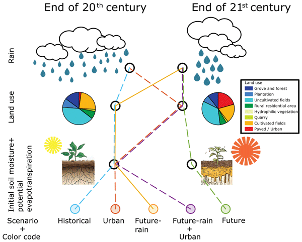
Different scenarios were used to assess the impact of individual and joint climate and land use changes on future hydrological properties (Fig. 3):
-
Urban: in this scenario we evaluate the isolated impact of future urbanization by representing late 21st century land use projections while maintaining late 20th century conditions for rainstorms, initial soil water storage, and potential evapotranspiration.
-
Future-rain: in this scenario we assess the isolated effect of future precipitation changes by reflecting projected future rainstorms while maintaining late 20th century conditions for land use, initial soil water storage, and potential evapotranspiration.
-
Future-rain + urban: in this scenario we evaluate the combined impact of future rainfall and land use change while maintaining late 20th century conditions for initial soil water storage and potential evapotranspiration.
-
Future: in this scenario we assess the combined impact of all anticipated changes by representing projected future conditions for rainstorms, land use, initial soil water storage, and potential evapotranspiration.
To identify changes across all different scenarios we compared them to the Historical scenario, which serves as a benchmark.
-
Historical: representing late 20th century conditions with corresponding rainstorms, land use, initial soil water storage, and potential evapotranspiration.

Figure 3Schematic sketch of the various scenarios used in this study. Land use pie charts are for Upper Dalya. Color coding for the different scenarios is fixed for all figures.
4.2 Projected changes in hydrological properties
Projected changes in outlet peak discharge, outlet flood volume, and soil water storage during peak discharge (peak soil water storage) were evaluated by comparing the four scenarios – Urban, Future-rain, Future-rain + Urban, and Future to the Historical scenario (Fig. 4). For each of the discrete 32 events we use the median value among all 43 spatial ensemble shifts and utilize the t-test and Wilcoxon signed rank test (both with significance level of 0.05) to examine whether the hydrological properties under each of the four scenarios significantly differ from the Historical scenario (Table 2; Fig. 4). It is important to emphasize that these event-based results do not capture potential shifts in flood frequency or seasonal dynamics.

Figure 4Streamflow peak discharge (a), streamflow volume (b), and peak soil water storage (c) for the four different scenarios compared to the Historical scenario. Box plots are composed of 32 values, where each of these values is the median of 43 spatial shifts for a single storm. Significant differences (p value <0.05) between each scenario and the Historical scenario are marked by ∗ for the t-test and by + for the Wilcoxon signed rank test. Similar plots for the other three basins appear in Fig. S2 in the Supplement.
Table 2Relative change in calculated means and medians for each scenario and the historical one.

Urban scenario
Urban and Historical scenarios share identical meteorological conditions and initial soil water storage properties, and differ only in land use (Fig. 3). As a result of the expansion of urban areas the outlet streamflow peak discharge and volume increased significantly, by 43 % and 41 %, respectively, for the mean values (Table 2). While the mean urban peak soil water storage value does not significantly differ from that of the Historical scenario, its distribution is skewed as indicated by its lower box and whisker. This skewness reflects the tendency of urbanized areas to reach high soil water storage levels more easily, even during events with relatively low rainfall depth.
Future-rain
The Future-rain scenario is identical to the Historical scenario in all aspects except for rainfall characteristics (Fig. 2). In this scenario, all the examined hydrological parameters decrease. The mean streamflow peak discharge and volume for the 32 tested rainfall events decline by 21 % and 30 %, respectively, and mean basin average peak-soil water storage decreases by 12 %. This reduction occurs despite an increase in Future-rain intensities, as the decrease in total storm rainfall, storm duration, and rainfall area (Fig. 2) have a more significant impact.
Future-rain + Urban
In this scenario, future rainfall and projected urban land use are combined. When applied individually, the two scenarios show opposing trends in peak discharge and volume. However, when combined, the influence of urban land use dominates, leading to an increase in both peak discharge and volume by 13 % and 1 %. This occurs despite a decrease in basin-average peak-soil water storage (−6 %) and is attributed to the increased impervious area and future rainfall rate intensification.
Future
In this scenario, we applied the projected inputs for rainfall, land use, initial soil water storage and evapotranspiration. The changes in initial soil water storage and potential evapotranspiration have little impact as evident by the similar results to the Future-rain + Urban scenario and points to its low significance as soil water storage builds up during the event and the intra-event evapotranspiration is negligible.
4.3 Event dynamics
To better understand why future floods in eastern Mediterranean regions can exhibit contrasting trends under different scenarios, we analyze the temporal dynamics of two representative flood response types, named here: undersaturated and saturated (Fig. 5). In both types, future rainfall depth decreases while maximal rainfall intensity increases. The main difference between the two types lies in the Future basin-averaged soil water storage for the shift that resulted in median outlet peak discharge (bold orange line in Fig. 5). In undersaturated events (peak soil water storage in Future rain scenario ≤90 %), Future-rain soil water storage remains undersaturated throughout the storm, while in saturated events (peak soil water storage in Future-rain scenario >90 %) soil water storage reaches high saturation rate before the peak discharge in all scenarios. This difference results in different hydrological response. Undersaturated events account for most of analyzed storms – approximately 62 %, and saturated events represent approximately 28 % of the storms.

Figure 5Basin-averaged accumulated rainfall, 10 min rainfall intensity, soil water storage, and outlet discharge of typical undersaturated (a) and saturated (b) events. Colored shaded areas show the 10–90 percentiles calculated for each time step from the 43 rainstorm shifts; solid lines represent the shift that resulted in median outlet peak discharge. Rainfall data for the Urban scenario is not presented as it is identical to the Historical one.
4.3.1 Undersaturated events
In a representative undersaturated event (Fig. 5; event #25 in Tables S1 and S2 in the Supplement) the historical basin-average accumulated rainfall depth (blue line) is 60 mm compared to 40 mm in the Future-rain scenario (orange line; all numbers in this section correspond to the rain-shift that resulted in the median outlet peak discharge – marked by a solid line in Fig. 5). Maximum 10 min basin-average rainfall intensities increased by 60 % from 14.6 mm h−1 in the Historical scenario to 23.1 mm h−1 in the Future-rain scenario. However, in the Future-rain scenario, these high rainfall intensities occurred following low accumulated rainfall depth (17 mm) and moderate soil water storage (80 %), resulting in low stream discharge (<1 m3 s−1). The future rainfall intensity that occurs just before the streamflow peak is 6.4 mm h−1 and occurs after 37 mm of future rainfall and basin-average soil water storage of 90 %, resulting in an increase of Future-rain peak discharge to 3.6 m3 s−1. In contrast, in the Historical scenario, the maximum 10 min rainfall intensity that occurred just before the streamflow peak, is 7 mm h−1. This intensity is similar to the preceding streamflow peak future rainfall intensity, but the soil water storage in the Historical scenario is close to saturation and leads to a significantly greater streamflow discharge of 8 m3 s−1. During undersaturated events the role of impervious land use in runoff generation is particularly significant. In the Urban scenario (red line), the impervious areal coverage in the Upper Dalya basin is considerably higher. Thus, the urban total basin-average soil water storage is higher than in the Historical scenario and the basin is more sensitive to rainfall occurrence. The peak discharge in this scenario is higher by 37 % than in the Historical one, even though they share exactly the same historical rainfall. Total flood volume in the Urban scenario is also greater by 32 % than in the Historical scenario and by 461 % than in the Future-rain scenario.
4.3.2 Saturated events
In the saturated events, total rainfall depths are high and soil water storage approaches saturation in all scenarios. In the representative example (Fig. 5; event #2 in Tables S1 and S2) saturation occurs after approximately 60 h from the beginning of the rainstorm. At these high soil water storage conditions, future rainfall intensities can result in increased Future-rain flood response and the relative contribution of the impervious urban sections weakens. Basin-average storm rainfall depths were 130 and 110 mm for the Historical and Future-rain scenarios, respectively. As in the undersaturated event, future maximum basin-average rain intensities (17 mm h−1) were higher than the historical ones (10 mm h−1) marking an increase of 70 %. However, after approximately 60 mm of accumulated rainfall, the basin-average soil moisture storage approaches saturation. At this stage, rainfall intensities play a major role in determining the discharge magnitude. In the Future-rain scenario, rainfall intensity, preceding the streamflow peak, is 15 mm h−1 resulting in a high peak discharge of 47 m3 s−1, while the Historical scenario yielded a lower streamflow peak discharge of 36 m3 s−1. Due to the reduced rainfall depth, streamflow volume in the Future-rain scenario is lower by 35.7 % than in the Historical scenario and by 43.7 % from the Urban one. In such events, where soil moisture approaches saturation, the relative contribution of impervious surfaces, such as urban areas, to peak discharge decreases (Rinat et al., 2018). Consequently, in the Urban scenario, the peak discharge is lower than for the Future-rain one and exceeds the Historical scenario peak discharge by only 5 % and by 14 % for total volume.
4.4 The spatial impact of future rainfall and urbanization
To further understand the hydrological dynamics within the basin, we calculated the normalized change of each scenario: Future-rain, Urban, and Future-rain + Urban, relative to the Historical benchmark. Results from the Future scenario are not presented as they were not significantly different from those of the Future-rain + Urban one. We first compare results from undersaturated and saturated events (see Sect. 4.3) for a single storm-shifting for each scenario corresponding to the median outlet peak discharge (bold lines in Fig. 5). This approach enables a spatial comparison between two individual rainstorms.
4.4.1 Undersaturated events
In the representative example of undersaturated events (Sect. 4.3; event #25 in Tables S1 and S2) the peak discharge decreases for the Future-rain scenario but increases for the urbanization scenario with either historical or Future-rain conditions (Fig. 6). The slight increase in discharge observed in the northeastern part of the basin under Future-rain conditions diminishes downstream, as for most of the basin Future-rain discharge values are lower than those in the Historical scenario. The basin's hydrological sensitivity to land-use change is evident, as urbanized sections with low infiltration capacity generate high local discharge that propagates towards the outlet. Overall, the combined Future-rain + Urban scenario results in reduced discharge across most basin sections compared with the Urban one.

Figure 6An example of the spatial intra-basin hydrological relative change of different scenarios compared to the Historical one for undersaturated event (left) and saturated event (right). Results show the relative change of peak discharges at each pixel for a single storm shift resulting in the outlet median peak discharge (bold line in Fig. 5). Light gray polygons in the lower two panels represent areas of major projected urbanization changes. Other, less significant land use variations (Fig. 1c), are not represented in this figure. Results for the future scenario are not shown as they are not significantly different from the Future-rain + Urban scenario.
4.4.2 Saturated events
In saturated events (Sect. 4.3; event #2 in Tables S1 and S2) Future-rain scenario result in increased peak discharges compared to the Historical ones across all basin sections (Fig. 6). This is mostly pronounced in upstream sections and, to a lesser extent, in the integrated outlet peak discharge. This suggests that, in such cases, the localization and intensification of Future-rain cells dominates local hydrological response. However, when most of the basin is saturated, the relative contribution of urbanized areas to local flood intensification and outlet peak discharge is reduced. This is reflected in the near-zero normalized change in stream cells draining these regions in the Urban scenario, and in the minimal contribution observed in the Future-rain + Urban scenario compared with the Future-rain scenario (Fig. 6).
4.4.3 Integrated spatial impact
Spatial variability in the changes in discharge (Sect. 2.5), driven by conflicting trends in projected rainfall characteristics, is evident when comparing the Future-rain scenario to the Historical benchmark (Fig. 7). The 90th percentile of the normalized change is positive at all stream sections where the 10th percentile shows opposite trend. The median indicates a negative normalized change at downstream, high stream orders, and neutral at upper basin sections. This suggests that, in typical events, the localization and intensification of future rainfall (Fig. 2) can enhance the local hydrological response in headwater streams. However, because not all basin sections experience increased discharge during the same event under the Future-rain scenario, this effect is attenuated downstream and the change becomes negative for the integrated outlet response.

Figure 7Similar to Fig. 6 but accounting for all storms and spatial rainfall shifts. The columns represent the 10th, 50th, and 90th percentiles of the 32 relative changes computed between each tested rainstorm scenario and the historical benchmark. Similar plots for the other three basins are in Fig. S3 in the Supplement.
The increased urbanization (Urban) scenario exhibits increased peak discharge throughout stream sections draining urbanized areas, evident in both the 50th and 90th percentiles. Even at the 10th percentile, most sections show slightly positive values at the Urban scenario. Notably, land use change has a more substantial impact than Future-rain change as their combined effect amplifies peak discharge in most stream cells at the downstream of urbanized areas (50th and 90th percentiles). Only when combining the Urban scenario with Future-rain, the 10th percentile map shows near-zero or negative values across all basin sections.
These findings underscore the critical importance of accounting for intra-basin variability when evaluating hydrological impacts under both changing climate and urbanization conditions. Analyzing individual stream cells reveals spatial patterns that are obscured when examining only outlet behavior, providing a more comprehensive understanding of basin-wide hydrological responses.
5.1 Contradictory trends
The Mediterranean region is known as a climate change hot-spot where annual precipitation decreases but rainfall intensities increase. As a result, high-impact floods are often reported in the media as climate change related (Al-Saqaf and Berglez, 2019; Cortiços and Duarte, 2025; Cremonini et al., 2024; Llasat et al., 2009). However, this is not always the case (e.g., Armon et al., 2025), in fact, recent studies around the world (Ionno et al., 2024; Meresa et al., 2022; Pal et al., 2023; Taniguchi et al., 2022; Wasko et al., 2021) including in the Mediterranean (Alfieri et al., 2015; Blöschl et al., 2019; Moore et al., 2006; Poncet et al., 2024; Di Sante et al., 2021; Wasko and Sharma, 2017) show current and future contradictory flood trends.
These contradictory trends are a direct result of changes in future properties that act in opposite ways to counterbalance or support flood intensification. Some trends in rainfall properties act to suppress flood peaks and volumes, these include: decreased rainstorm frequency, shortening of the rainfall season and event duration, reduction of annual and event rainfall depth, reduced rainfall area, and prolongation of the inter-event time (e.g., Alfieri et al., 2015; De Girolamo et al., 2022; Peleg et al., 2015). Soil water storage levels are reduced due to the same rainfall trends as well as the increased evapotranspiration rates and add to this damping (e.g., Mediero et al., 2014; Tramblay et al., 2019, 2023; Wasko et al., 2021). In contrast to these suppressing effects, rain rate intensification, urbanization, and soil erosion can act to increase flood magnitudes (e.g., Faccini et al., 2021; López-Moreno et al., 2006; Wasko et al., 2021). In urban regions rain intensity becomes the dominant factor; driving an increase in runoff magnitude (Yang et al., 2016). Finally, agricultural expansion and poor cultivation practices degrade soil (Amundson et al., 2015), reduce water storage and contribute to runoff intensification (Hillel, 1998).
The regional and local effects of these counterbalancing factors on flood trends are reported in recent studies. Blöschl et al. (2019) and Tramblay et al. (2023) found a decrease in observed flood intensities due to decrease in soil water storage, mainly for large agricultural basins with low urbanization (Tramblay et al., 2019). Bertola et al. (2020), analyzed European flood records and found that flood trends depend on the region, magnitude, and basin-size. They found that, in general, Mediterranean floods peak discharges are decreasing, while the trend is smaller at extreme floods or small basins. Poncet et al. (2024) studied projected floods in a medium size basin at southern France and found intensification of large floods but magnitude decrease in smaller ones as a result of low soil water storage and base flow reduction. Di Sante et al. (2021) found that daily peak flows are mostly decreasing, although some Mediterranean regions, such as: southern Spain, southern Italy, and Israel show a non-significant increasing signal. They also state that extreme floods generally increase in medium (100–1000 km2) basins and decrease for larger ones.
In this study, we find that, in the eastern Mediterranean, future rainfall tends to reduce flood peak discharge magnitude and volume and that urbanization acts to increase it. While both factors act in opposite directions the influence of urbanization in our research setting is higher even when initial soil water reduction and increased potential evapotranspiration are accounted for (Future scenario in Fig. 4). This is supported by various studies, for example: Ramezani et al. (2023) studied the effect of climate change and urbanization in 6 medium basins in eastern Australia and showed that climate change mostly results in runoff reduction, while urbanization causes runoff to considerably increase. When both scenarios are combined climate change only moderates the urbanization impact (Kalantari et al., 2017). However, in less urbanized basins, when different runoff management actions are taken (Ahammed, 2017; Chen et al., 2009), or in other regions climate change effects might become more pronounced. For example, Arnone et al. (2018) found that runoff extremes are dominated by variations in climate change even when urban regions increase from 1.5 % to 25 % basin coverage.
This interaction between local rainfall projections and environmental change can lead to different trends between and within regions, between neighboring basins (Tramblay et al., 2019), or even within a basin (Sect. 4.4; Figs. 6 and 7). Further caution is needed as these complex behaviors must be taken under consideration when preparing for future flood hazards (Llasat, 2021). In this study we used a unique high-resolution distributed hydrological model that uncovers inter- and intra-basin flood response variability. We find that as future rainfall is projected to become even more localized, intense basin headwater sections can experience increased local runoff. At the same time, such a scenario does not necessarily translate to increased outlet discharge. However, it can cause local flooding, erosion at headwater sections, debris flow and landslides (Grodek et al., 2012; Shmilovitz et al., 2023). When intense localized rainfall occurs in urbanized areas, or when preferable settings, such as high soil water storage (Saturated events, Figs. 5 and 6) prevail it can result in extreme hydrological response (Morin and Yakir, 2014). We therefore encourage researchers, decision makers and stakeholders to consider the different and combined effects climate change and land use change have on floods within different parts of the basin when preparing for future challenges.
5.2 Study limitations
Recent studies in the Mediterranean have analyzed observed data to identify flood trends. In the present study, such trends could not be reliably determined due to limited, non-homogeneous flood measurements and the influence of ongoing land use changes. Moreover, observed flood trends do not necessarily reflect future conditions (Blöschl et al., 2019) as these require the use of meteorological and hydrological models (Hall et al., 2014). Future flood projections are subject to significant uncertainties due to long-term simulation periods and complex modeling chains (Noto et al., 2023b). In addition, the coarse spatiotemporal resolution of global or regional meteorological models fails to accurately represent convective rainfall and the impact of mountain ranges and coastlines that are typical to the Mediterranean (Armon et al., 2022; Berthou et al., 2020; Marra et al., 2022; Noto et al., 2023b; Prein et al., 2015). Similarly, large-scale or even higher resolution semi-distributed hydrological models struggle to capture the Mediterranean's intra-basin spatiotemporal variability, particularly in small to medium-sized basins (Fatichi et al., 2016; Merheb et al., 2016).
To mitigate these limitations high-resolution convection permitting models and detailed hydrological models are employed. Convection permitting weather models better represent extreme short-duration rainfall and climate change scenarios (Poncet et al., 2024) which are crucial for hydrological studies (Ascott et al., 2023) particularly at small to medium basins and urban regions (Arnaud et al., 2011; Cristiano et al., 2017; Dayan and Morin, 2006; Paschalis et al., 2014; Singh, 1997; Yakir and Morin, 2011; Zoccatelli et al., 2011). Subsequently, high-resolution hydrological models are utilized to account for complex hydrological processes driven by high spatiotemporal rainfall and basin characteristics (Downer et al., 2002; Fatichi et al., 2016; Merheb et al., 2016; Moretti and Montanari, 2007; Rinat et al., 2018). However, despite their proven ability to accurately simulate intense rainfall and heavy precipitation events, convection permitting models remain underutilized in hydrological studies, especially in the Mediterranean region (Peleg et al., 2020; Poncet et al., 2024).
Long-term (∼10 years) high-resolution simulations of climate change are becoming available for limited regions (e.g., Berthou et al., 2020; Liu et al., 2017). However, their use remains limited because they are available for only a few regions and typically cover short time periods. As a result, large parts of the world, including the eastern Mediterranean, are still excluded from such simulations. We thus employed an event-based pseudo-global warming methodology, which offers cost-effective, high-resolution simulation of climate change impact on precipitation at a relatively low-cost, but contains only a limited number of events and does not allow for frequency analysis. In addition, the present study relies on a single high-emissions (RCP8.5) climate forcing based on the CMIP5 ensemble mean. Consequently, the results should not be interpreted as probabilistic or precise quantitative projections of future flood response, but rather as an assessment of the direction and relative hydrological impacts of climate and land-use changes under a strong warming scenario (e.g., Van Vuuren et al., 2026). Lower-emission scenarios would likely result in weaker climate-change signals. The use of multiple emission scenarios and climate forcings would enable probabilistic assessment of future flood response, but such convection-permitting ensemble simulations remain computationally demanding and are currently unavailable for the eastern Mediterranean region.
Moreover, events were identified based on heavy precipitation across the broader eastern Mediterranean region, not the specific study site. Consequently, the tested extreme rainfall series is incomplete and does not fully represent the range of potential scenarios. Comprehensive long-term, high-resolution simulations are essential for a full representation of the hydrometeorological processes, including: multi-year, annual, seasonal, and extreme/low-value analyses. Such analyses are crucial for flood impact analysis, mitigation, and prevention (Llasat, 2021). We intend to conduct complementary research in the eastern Mediterranean to study the projected flood frequencies due to climate and environmental changes in the region based on future availability of longer-term model output.
5.3 Future runoff contribution and adaptation strategies
Water resources in the Mediterranean are limited (Milano et al., 2013). Agriculture dominates water consumption, accounting for 64 % of usage, followed by domestic (20 %) and industrial needs (16 %) (Burak and Margat, 2016). Projected increases in water demand are attributed to population growth, rising living standards, expanded irrigation practices, rapid urbanization, and even increased tourism (García-Ruiz et al., 2011; Lana-Renault et al., 2020; Milano et al., 2013; Zdruli, 2014).
Even though most of the Mediterranean streams are seasonal or ephemeral (Bonada and Resh, 2013; Skoulikidis et al., 2017) they play a significant role in contributing to renewable water resources (Masseroni et al., 2021). In particular, heavy precipitation events play a crucial role enriching groundwater, reservoirs, and lakes (Armon et al., 2024; Milewski et al., 2009; Moawad et al., 2016; Nasta et al., 2018; Samuels et al., 2009).
In recent decades annual stream volumes in the Mediterranean have decreased in a rate of approximately 1×10³ (Masseroni et al., 2021), leading to reduced lake levels and diminished renewable water resources (Myronidis et al., 2012). Projections indicate that this trend will persist, with decreasing annual river runoff at large basins and reduced low-flows (De Girolamo et al., 2022; Marx et al., 2018; Schneider et al., 2013; Sellami et al., 2016). Such changes are likely to negatively affect groundwater recharge (Braca et al., 2019) and result in further declines in lake and reservoir water levels (Bucak et al., 2017; Zabalza-Martínez et al., 2018).
To address increasing water demand and scarcity, numerous reservoirs have been constructed across the Mediterranean in recent years to capture stream runoff and mitigate groundwater recharge reductions (Skoulikidis et al., 2017). Since the late 1960s, at the Ramot Menashe study site stream flow is diverted to several small reservoirs for irrigation. Additionally, approximately 10×106 m3 is annually diverted from the downstream sections of Upper Taninim and Ada basins to the Menashe streams managed aquifer recharge system. While this volume constitutes only ∼0.6 % of Israel's total estimated natural water resources, these readily available waters are critical to the region's water resilience (Kurtzman and Guttman, 2020).
Our findings reveal that in small to medium-sized Mediterranean basins future rainfall scenarios translate to a significant decrease in flood volumes (averaging −30 %). However, given our experiment design, substantial urban development is projected to result in a 41 % increase in flood volumes (mean increase; Table 2, Fig. 4). When the combined effects of future rainfall and urbanization are considered, mean flood volumes remain rather unchanged. When accounting for all factors – urbanization, future rainfall, future initial soil water storage, and future potential evapotranspiration – flood volumes are expected to decline slightly (averaging −8 %).
Our results highlight the critical need for adaptive water management strategies. In rural regions, projected declines in stream volumes necessitate the adoption of sustainable and water-efficient agricultural practices and the development of alternative water sources such as wastewater treatment (Ait-Mouheb et al., 2020) and seawater desalination (Curto et al., 2021). Conversely, urban areas face heightened vulnerability due to increased flood magnitudes, particularly during extreme precipitation events (Nussbaum et al., 2026). This urban hydrological pressure is exemplified in Israel which has experienced rapid population growth over the last eight decades (Orenstein and Hamburg, 2010; Tal, 2016), that is projected to persist (Phren and Klinger, 2017).
Historically, urban flood hazard mitigation has exclusively relied on the rapid centralized evacuation of stormwater. However, during intense rainfall, these drainage systems often contribute to urban flooding and increase downstream peak flows (Fletcher et al., 2024; Xu et al., 2023). To mitigate these risks, other measures have been developed and implemented in recent decades. Nature-based solutions such as: urban green parks, urban forests, green roofs, and green walls attenuate runoff, while detention and retention ponds store stormwater to reduce peak discharges and volumes and increase hydrological lag times (Ben Dor et al., 2025; Esraz-Ul-Zannat et al., 2024; Fletcher et al., 2013, 2024; Xu et al., 2023). Infiltration and groundwater recharge can be enhanced by using permeable pavements and rooftop rainwater harvesting (e.g., Esraz-Ul-Zannat et al., 2024; Nachshon et al., 2016; Netzer et al., 2024; Saha et al., 2024). However, the efficacy of these infiltration-based interventions is highly dependent on local geology; for example, they may be ineffective in our study site, which is characterized by thick, impermeable bedrock (Kurtzman and Guttman, 2020).
In this study, we investigated the impacts of projected climate and land use changes on flood properties within small to medium-sized catchments located at the eastern Mediterranean region of Israel. Under climate change, rainfall is expected to become more localized and intense while total amounts decrease. At the same time, soil water storage levels are projected to decline, and urban development is likely to increase built-up, impervious surfaces. Our findings highlight the complex interplay of such counteracting factors influencing flood parameters:
-
We find that, in general, projected floods are decreasing even in the context of increased rainfall intensities as other damping factors come into play.
-
Urbanization, on the other hand, can significantly increase flood peak discharge and volume at current and future climate conditions.
-
In our research settings, the influence of urbanization predominates, especially when conditions of low soil water storage prevail.
-
Despite general declining flood magnitudes, intensification is projected to occur mainly in upstream and urbanized areas, expanding basin-wide during extreme events when saturation is high and rainfall intensification dominate the hydrological response.
-
Therefore, while in general flood risk and flood-contributed water resources may decrease at stream outlets, hydrometeorological hazards may increase in headwater and urban regions and should be accounted for.
The projected decrease in flood volumes poses a challenge for water resource management, as water scarcity issues are already prevalent in the Mediterranean. In contrast, the increased flood magnitude associated with upstream sections and urbanization demands the implementation of effective and local flood mitigation strategies to protect vulnerable communities and infrastructure. This complex combined effect of urbanization and climate change underscore the need to conduct further studies on projected flood frequencies and impact.
Data of historical and projected rainfall simulations, including the complete WRF namelist input files, are available from Armon et al. (2022). Measured rainfall and air temperature gauge data used for the DREAM model were obtained from the Israel Meteorological Service (IMS, 2025). Land use data were obtained from Israel Planning Administration IPA (2025). The daily recharge assessment model DREAM is described in detail by Sheffer et al. (2010). A comprehensive description of the GB-HYDRA hydrological model and its parameterization is provided by Rinat et al. (2018).
The supplement related to this article is available online at https://doi.org/10.5194/hess-30-4565-2026-supplement.
YR and EM conceptualized the work. The methodology and software were developed by YR and MA. Data analysis was performed by YR and MA. Funding was acquired by EM and MA. YR wrote the original draft of this paper, which was reviewed and edited by all co-authors.
The contact author has declared that none of the authors has any competing interests.
Publisher's note: Copernicus Publications remains neutral with regard to jurisdictional claims made in the text, published maps, institutional affiliations, or any other geographical representation in this paper. The authors bear the ultimate responsibility for providing appropriate place names. Views expressed in the text are those of the authors and do not necessarily reflect the views of the publisher.
The authors thank Israel Planning Administration for providing projected land use maps for the study region.
This research has been supported by the ISF (grant no. 1999/22). MA was supported by the Swiss National Science Foundation (grant no. TMPFP2_216989), by the Med World and the Tuning for Deserts consortia, funded by the Council for Higher Education in Israel, and by the Israel Science Foundation research grant (ISF's No. 4089/25) and the Maimonides Fund's Future Scientists Center.
This paper was edited by Daniel Viviroli and reviewed by two anonymous referees.
Ahammed, F.: A review of water-sensitive urban design technologies and practices for sustainable stormwater management, Sustain. Water Resour. Manag., 3, 269–282, https://doi.org/10.1007/s40899-017-0093-8, 2017.
Ait-Mouheb, N., Mayaux, P. L., Mateo-Sagasta, J., Hartani, T., and Molle, B.: Water reuse: A resource for Mediterranean agriculture, Elsevier Inc., 107–136, https://doi.org/10.1016/B978-0-12-818086-0.00005-4, 2020.
Al-Saqaf, W. and Berglez, P.: How Do Social Media Users Link Different Types of Extreme Events to Climate Change? A Study of Twitter During 2008–2017, Journal of Extreme Event, 6, 1950002, https://doi.org/10.1142/S2345737619500027, 2019.
Alfieri, L., Burek, P., Feyen, L., and Forzieri, G.: Global warming increases the frequency of river floods in Europe, Hydrol. Earth Syst. Sci., 19, 2247–2260, https://doi.org/10.5194/hess-19-2247-2015, 2015.
Ali, E., Cramer, W., Carnicer, J., Georgopoulou, E., Hilmi, N. J. M., Le Cozannet, G., and Lionello, P.: Cross-Chapter Paper 4: Mediterranean Region., in: Climate Change 2022: Impacts, Adaptation and Vulnerability, Contribution of Working Group II to the Sixth Assessment Report of the Intergovernmental Panel on Climate Change, Cambridge, UK and New York, NY, USA, 2233–2272, https://doi.org/10.1017/9781009325844.021, 2022.
Allam, A., Moussa, R., Najem, W., and Bocquillon, C.: Hydrological cycle, Mediterranean basins hydrology, in: Water Resources in the Mediterranean Region, Elsevier Inc., 1–21, https://doi.org/10.1016/B978-0-12-818086-0.00001-7, 2020.
Allen, R. G., Pereira, L. S., Raes, D., and Smith, M.: Crop evapotranspiration – Guidelines for computing crop water requirements – FAO Irrigation and drainage paper 56, Rome, 1–15, https://doi.org/10.1016/j.eja.2010.12.001, 1998.
Amundson, R., Berhe, A. A., Hopmans, J. W., Olson, C., Sztein, A. E., and Sparks, D. L.: Soil and human security in the 21st century, Science, https://doi.org/10.1126/science.1261071, 2015.
Armon, M., Marra, F., Enzel, Y., Rostkier-Edelstein, D., and Morin, E.: Radar-based characterisation of heavy precipitation in the eastern Mediterranean and its representation in a convection-permitting model, Hydrol. Earth Syst. Sci., 24, 1227–1249, https://doi.org/10.5194/hess-24-1227-2020, 2020.
Armon, M., Marra, F., Enzel, Y., Rostkier-Edelstein, D., Garfinkel, C. I., Adam, O., Dayan, U., and Morin, E.: Reduced Rainfall in Future Heavy Precipitation Events Related to Contracted Rain Area Despite Increased Rain Rate, Earths Future, 10, 1–19, https://doi.org/10.1029/2021EF002397, 2022.
Armon, M., de Vries, A. J., Marra, F., Peleg, N., and Wernli, H.: Saharan rainfall climatology and its relationship with surface cyclones, Weather Clim. Extrem., 43, 100638, https://doi.org/10.1016/j.wace.2023.100638, 2024.
Armon, M., Shmilovitz, Y., and Dente, E.: Anatomy of a Foreseeable Disaster: Lessons from the 2023 Dam-Breaching Flood in Derna, Libya, Sci. Adv., 2865, 1–9, https://doi.org/10.1126/sciadv.adu2865, 2025.
Arnaud, P., Lavabre, J., Fouchier, C., Diss, S., and Javelle, S. P.: Sensitivity of hydrological models to uncertainty in rainfall input, Hydrolog. Sci. J., 56, 397–410, https://doi.org/10.1080/02626667.2011.563742, 2011.
Arnone, E., Pumo, D., Francipane, A., La Loggia, G., and Noto, L. V.: The role of urban growth, climate change, and their interplay in altering runoff extremes, Hydrol. Process., 32, 1755–1770, https://doi.org/10.1002/hyp.13141, 2018.
Ascott, M. J., Christelis, V., Lapworth, D. J., Macdonald, D. M. J., Tindimugaya, C., Iragena, A., Finney, D., Fitzpatrick, R., Marsham, J. H., and Rowell, D. P.: On the application of rainfall projections from a convection-permitting climate model to lumped catchment models, J. Hydrol., 617, 129097, https://doi.org/10.1016/j.jhydrol.2023.129097, 2023.
Barredo, J. I.: Major flood disasters in Europe: 1950–2005, Nat. Hazards, 42, 125–148, https://doi.org/10.1007/s11069-006-9065-2, 2007.
Ben Dor, Y., Sharabi, G., Nussbaum, R., Alian, S., Morin, E., Freiman, E., Lind, A., Shemesh, I., Balaban, A., Ozinsky, R., and Levintal, E.: Beyond the Flow: The Many Facets of Gazelle Valley Park (Jerusalem), an Urban Nature-Based Solution for Flood Mitigation in a Mediterranean Climate, Land, 14, 1–21, https://doi.org/10.3390/land14112174, 2025.
Berthou, S., Kendon, E. J., Chan, S. C., Ban, N., Leutwyler, D., Schär, C., and Fosser, G.: Pan-European climate at convection-permitting scale: a model intercomparison study, Clim. Dynam., 55, 35–59, https://doi.org/10.1007/s00382-018-4114-6, 2020.
Bertola, M., Viglione, A., Lun, D., Hall, J., and Blöschl, G.: Flood trends in Europe: are changes in small and big floods different?, Hydrol. Earth Syst. Sci., 24, 1805–1822, https://doi.org/10.5194/hess-24-1805-2020, 2020.
Bertola, M., Viglione, A., Vorogushyn, S., Lun, D., Merz, B., and Blöschl, G.: Do small and large floods have the same drivers of change? A regional attribution analysis in Europe, Hydrol. Earth Syst. Sci., 25, 1347–1364, https://doi.org/10.5194/hess-25-1347-2021, 2021.
Blöschl, G., Hall, J., Viglione, A., Perdigão, R. A. P., Parajka, J., Merz, B., Lun, D., Arheimer, B., Aronica, G. T., Bilibashi, A., Boháč, M., Bonacci, O., Borga, M., Čanjevac, I., Castellarin, A., Chirico, G. B., Claps, P., Frolova, N., Ganora, D., Gorbachova, L., Gül, A., Hannaford, J., Harrigan, S., Kireeva, M., Kiss, A., Kjeldsen, T. R., Kohnová, S., Koskela, J. J., Ledvinka, O., Macdonald, N., Mavrova-Guirguinova, M., Mediero, L., Merz, R., Molnar, P., Montanari, A., Murphy, C., Osuch, M., Ovcharuk, V., Radevski, I., Salinas, J. L., Sauquet, E., Šraj, M., Szolgay, J., Volpi, E., Wilson, D., Zaimi, K., and Živković, N.: Changing climate both increases and decreases European river floods, Nature, 573, 108–111, https://doi.org/10.1038/s41586-019-1495-6, 2019.
Bonada, N. and Resh, V. H.: Mediterranean-climate streams and rivers: Geographically separated but ecologically comparable freshwater systems, Hydrobiologia, 719, 1–29, https://doi.org/10.1007/s10750-013-1634-2, 2013.
Borga, M., Comiti, F., Ruin, I., and Marra, F.: Forensic analysis of flash flood response, WIREs Water, 1–9, https://doi.org/10.1002/wat2.1338, 2019.
Braca, G., Bussettini, M., Ducci, D., Lastoria, B., and Mariani, S.: Evaluation of national and regional groundwater resources under climate change scenarios using a GIS-based water budget procedure, Rend. Lincei, 30, 109–123, https://doi.org/10.1007/s12210-018-00757-6, 2019.
Bucak, T., Trolle, D., Andersen, H. E., Thodsen, H., Erdoğan, Ş., Levi, E. E., Filiz, N., Jeppesen, E., Beklioğlu, M., and Bucak, T.: Future water availability in the largest freshwater Mediterranean lake is at great risk as evidenced from simulations with the SWAT model, Sci. Total Environ., 581, 413–425, https://doi.org/10.1016/j.scitotenv.2016.12.149, 2017.
Burak, S. and Margat, J.: Water Management in the Mediterranean Region: Concepts and Policies, Water Resour. Manag., 30, 5779–5797, https://doi.org/10.1007/s11269-016-1389-4, 2016.
Caldas-Alvarez, A., Augenstein, M., Ayzel, G., Barfus, K., Cherian, R., Dillenardt, L., Fauer, F., Feldmann, H., Heistermann, M., Karwat, A., Kaspar, F., Kreibich, H., Lucio-Eceiza, E. E., Meredith, E. P., Mohr, S., Niermann, D., Pfahl, S., Ruff, F., Rust, H. W., Schoppa, L., Schwitalla, T., Steidl, S., Thieken, A. H., Tradowsky, J. S., Wulfmeyer, V., and Quaas, J.: Meteorological, impact and climate perspectives of the 29 June 2017 heavy precipitation event in the Berlin metropolitan area, Nat. Hazards Earth Syst. Sci., 22, 3701–3724, https://doi.org/10.5194/nhess-22-3701-2022, 2022.
Chen, Y., Xu, Y., and Yin, Y.: Impacts of land use change scenarios on storm-runoff generation in Xitiaoxi basin, China, Quatern. Int., 208, 121–128, https://doi.org/10.1016/j.quaint.2008.12.014, 2009.
Cortiços, N. D. and Duarte, C. C.: Climate Resilience and Adaptive Strategies for Flood Mitigation: The Valencia Paradigm, Sustainability-Basel, 17, https://doi.org/10.3390/su17114980, 2025.
Cremonini, L., Randi, P., Fazzini, M., Nardino, M., Rossi, F., and Georgiadis, T.: Causes and Impacts of Flood Events in Emilia-Romagna (Italy) in May 2023, Land, 13, https://doi.org/10.3390/land13111800, 2024.
Cristiano, E., ten Veldhuis, M.-C., and van de Giesen, N.: Spatial and temporal variability of rainfall and their effects on hydrological response in urban areas – a review, Hydrol. Earth Syst. Sci., 21, 3859–3878, https://doi.org/10.5194/hess-21-3859-2017, 2017.
Curto, D., Franzitta, V., and Guercio, A.: A review of the water desalination technologies, Appl. Sci.-Basel, 11, 1–36, https://doi.org/10.3390/app11020670, 2021.
Dan, Y., Raz, Z., Yaalon, H., and Koyumdjisky, H.: Soil Map of Israel, https://esdac.jrc.ec.europa.eu/content/soil-map-isra%C3%ABl (last access: 15 February 2025), 1975.
Dayan, U. and Morin, E.: Flash flood-producing rain storms over the Dead Sea: review, in: New Frontiers in Dead Sea Paleoenvironmental Research, 253, https://doi.org/10.1130/2006.2401(04), 2006.
Dee, D. P., Uppala, S. M., Simmons, A. J., Berrisford, P., Poli, P., Kobayashi, S., Andrae, U., Balmaseda, M. A., Balsamo, G., Bauer, P., Bechtold, P., Beljaars, A. C. M., van de Berg, L., Bidlot, J., Bormann, N., Delsol, C., Dragani, R., Fuentes, M., Geer, A. J., Haimberger, L., Healy, S. B., Hersbach, H., Hólm, E. V., Isaksen, L., Kållberg, P., Köhler, M., Matricardi, M., Mcnally, A. P., Monge-Sanz, B. M., Morcrette, J. J., Park, B. K., Peubey, C., de Rosnay, P., Tavolato, C., Thépaut, J. N., and Vitart, F.: The ERA-Interim reanalysis: Configuration and performance of the data assimilation system, Q. J. Roy. Meteor. Soc., 137, 553–597, https://doi.org/10.1002/qj.828, 2011.
De Girolamo, A. M., Barca, E., Leone, M., and Lo Porto, A.: Impact of long-term climate change on flow regime in a Mediterranean basin, J. Hydrol. Reg. Stud., 41, 101061, https://doi.org/10.1016/j.ejrh.2022.101061, 2022.
Di Sante, F., Coppola, E., and Giorgi, F.: Projections of river floods in Europe using EURO-CORDEX, CMIP5 and CMIP6 simulations, Int. J. Climatol., 41, 3203–3221, https://doi.org/10.1002/joc.7014, 2021.
Donat, M. G., Lowry, A. L., Alexander, L. V., O'Gorman, P. A., and Maher, N.: More extreme precipitation in the world's dry and wet regions, Nat. Clim. Change, 6, 508–513, https://doi.org/10.1038/nclimate2941, 2016.
Doswell, A. C., Brooks, E. H., and Madox, A. R.: Flash flood forecasting: An ingredients-based methodology, Weather Forecast., 11, 560–581, 1996.
Downer, C. W., Ogden, F. L., Martin, W. D., and Harmon, R. S.: Theory, development, and applicability of the surface water hydrologic model CASC2D, Hydrol. Process., 16, 255–275, https://doi.org/10.1002/hyp.338, 2002.
Esraz-Ul-Zannat, M., Dedekorkut-Howes, A., and Morgan, E. A.: A review of nature-based infrastructures and their effectiveness for urban flood risk mitigation, WIREs Clim. Change, 15, 1–28, https://doi.org/10.1002/wcc.889, 2024.
Faccini, F., Luino, F., Sacchini, A., Turconi, L., and De Graff, J. V.: Geohydrological hazards and urban development in the Mediterranean area: an example from Genoa (Liguria, Italy), Nat. Hazards Earth Syst. Sci., 15, 2631–2652, https://doi.org/10.5194/nhess-15-2631-2015, 2015.
Faccini, F., Luino, F., Paliaga, G., Roccati, A., and Turconi, L.: Flash flood events along the west mediterranean coasts: Inundations of urbanized areas conditioned by anthropic impacts, Land, 10, https://doi.org/10.3390/land10060620, 2021.
Fang, B., Bevacqua, E., Rakovec, O., and Zscheischler, J.: An increase in the spatial extent of European floods over the last 70 years, Hydrol. Earth Syst. Sci., 28, 3755–3775, https://doi.org/10.5194/hess-28-3755-2024, 2024.
Fatichi, S., Vivoni, E. R., Ogden, F. L., Ivanov, V. Y., Mirus, B., Gochis, D., Downer, C. W., Camporese, M., Davison, J. H., Ebel, B., Jones, N., Kim, J., Mascaro, G., Niswonger, R., Restrepo, P., Rigon, R., Shen, C., Sulis, M., and Tarboton, D.: An overview of current applications, challenges, and future trends in distributed process-based models in hydrology, J. Hydrol., 537, 45–60, https://doi.org/10.1016/j.jhydrol.2016.03.026, 2016.
Fletcher, T. D., Andrieu, H., and Hamel, P.: Understanding, management and modelling of urban hydrology and its consequences for receiving waters: A state of the art, Adv. Water Resour., 51, 261–279, https://doi.org/10.1016/j.advwatres.2012.09.001, 2013.
Fletcher, T. D., Burns, M. J., Russell, K. L., Hamel, P., Duchesne, S., Cherqui, F., and Roy, A. H.: Concepts and evolution of urban hydrology, Nat. Rev. Earth Environ., 5, 789–801, https://doi.org/10.1038/s43017-024-00599-x, 2024.
García-Ruiz, J. M., López-Moreno, I. I., Vicente-Serrano, S. M., Lasanta-Martínez, T., and Beguería, S.: Mediterranean water resources in a global change scenario, Earth-Sci. Rev., 105, 121–139, https://doi.org/10.1016/j.earscirev.2011.01.006, 2011.
Gaume, E., Borga, M., Llasat, M. C., Maouche, S., Lang, M., and Diakakis, M.: Mediterranean extreme floods and flash floods. Into Hydro-meteorological extremes, in: The Mediterranean Region under Climate Change, A Scientific Update, 133–144, https://doi.org/10.4000/books.irdeditions.23181, 2016.
Giorgi, F.: Climate change hot-spots, Geophys. Res. Lett., 33, https://doi.org/10.1029/2006GL025734, 2006.
Giorgi, F. and Lionello, P.: Climate change projections for the Mediterranean region, Global Planet. Change, 63, 90–104, https://doi.org/10.1016/j.gloplacha.2007.09.005, 2008.
Giuntoli, I., Vidal, J.-P., Prudhomme, C., and Hannah, D. M.: Future hydrological extremes: the uncertainty from multiple global climate and global hydrological models, Earth Syst. Dynam., 6, 267–285, https://doi.org/10.5194/esd-6-267-2015, 2015.
Goldreich, Y.: The Climate of Israel, Observations, Research and Implementation, Springer S., New York, 292 pp., https://doi.org/10.1007/978-1-4615-0697-3, 2003.
Grodek, T., Jacoby, Y., Morin, E., and Katz, O.: Effectiveness of exceptional rainstorms on a small Mediterranean basin, Geomorphology, 159–160, 156–168, https://doi.org/10.1016/j.geomorph.2012.03.016, 2012.
Guth, P. L.: Drainage basin morphometry: a global snapshot from the shuttle radar topography mission, Hydrol. Earth Syst. Sci., 15, 2091–2099, https://doi.org/10.5194/hess-15-2091-2011, 2011.
Hall, J., Arheimer, B., Borga, M., Brázdil, R., Claps, P., Kiss, A., Kjeldsen, T. R., Kriaučiūnienė, J., Kundzewicz, Z. W., Lang, M., Llasat, M. C., Macdonald, N., McIntyre, N., Mediero, L., Merz, B., Merz, R., Molnar, P., Montanari, A., Neuhold, C., Parajka, J., Perdigão, R. A. P., Plavcová, L., Rogger, M., Salinas, J. L., Sauquet, E., Schär, C., Szolgay, J., Viglione, A., and Blöschl, G.: Understanding flood regime changes in Europe: a state-of-the-art assessment, Hydrol. Earth Syst. Sci., 18, 2735–2772, https://doi.org/10.5194/hess-18-2735-2014, 2014.
Hargreaves, H. G. and Samani, A. Z.: Reference Crop Evapotranspiration from Temperature, Appl. Eng. Agric., 1, 96–99, https://doi.org/10.13031/2013.26773, 1985.
Hillel, D.: Environmental Soil Physics, Academic Press, London, 771 pp., ISBN 978-0-12-348525-0, 1998.
Hochman, A., Harpaz, T., Saaroni, H., and Alpert, P.: The seasons' length in 21st century CMIP5 projections over the eastern Mediterranean, Int. J. Climatol., 38, 2627–2637, https://doi.org/10.1002/joc.5448, 2018.
Hochman, A., Marra, F., Messori, G., Pinto, J. G., Raveh-Rubin, S., Yosef, Y., and Zittis, G.: Extreme weather and societal impacts in the eastern Mediterranean, Earth Syst. Dynam., 13, 749–777, https://doi.org/10.5194/esd-13-749-2022, 2022.
IMS: Israel Meteorological Service, https://ims.gov.il/en (last access: 1 March 2026), 2025.
Inbar, M.: Natural disasters in israel, https://geo.hevra.haifa.ac.il/~inh/index.php/en/disasters-en/floods-en (last access: 5 May 2025), 2019.
Ionno, A., Arsenault, R., Troin, M., Martel, J. L., and Brissette, F.: Impacts of climate change on flood volumes over North American catchments, J. Hydrol., 630, https://doi.org/10.1016/j.jhydrol.2024.130688, 2024.
IPA: Israel Planning Administration, https://www.gov.il/en/departments/iplan/govil-landing-page (last access: 8 January 2025), 2025.
Jiang, L. and O'Neill, B. C.: Global urbanization projections for the Shared Socioeconomic Pathways, Global Environ. Chang., 42, 193–199, https://doi.org/10.1016/j.gloenvcha.2015.03.008, 2017.
Kalantari, Z., Ferreira, C. S. S., Walsh, R. P. D., Ferreira, A. J. D., and Destouni, G.: Urbanization Development under Climate Change: Hydrological Responses in a Peri-Urban Mediterranean Catchment, Land Degrad. Dev., 28, 2207–2221, https://doi.org/10.1002/ldr.2747, 2017.
Kemter, M., Merz, B., Marwan, N., Vorogushyn, S., and Blöschl, G.: Joint Trends in Flood Magnitudes and Spatial Extents Across Europe, Geophys. Res. Lett., 47, 1–8, https://doi.org/10.1029/2020GL087464, 2020.
Khain, P., Levi, Y., Shtivelman, A., and Vadislavsky, E.: Improving the precipitation forecast over the Eastern Mediterranean using a smoothed time-lagged ensemble, Meteorol. Appl., 1–17, https://doi.org/10.1002/met.1840, 2019.
Kurtzman, D. and Guttman, J.: Managed aquifer recharge with various water sources for irrigation and domestic use: A perspective of the Israeli experience, in: Global Groundwater: Source, Scarcity, Sustainability, Security, and Solutions, 597–607, https://doi.org/10.1016/B978-0-12-818172-0.00044-X, 2020.
Kushnir, Y., Dayan, U., Ziv, B., Morin, E., and Enzel, Y.: Climate of the Levant, in: Quaternary of the Levant, edited by: Enzel, Y. and Bar-Tosef, O., Cambridge University Press, Cambridge, 31–44, https://doi.org/10.1017/9781316106754.004, 2017.
Lana-Renault, N., Morán-Tejeda, E., Moreno de las Heras, M., Lorenzo-Lacruz, J., and López-Moreno, N.: Land-use change and impacts, Elsevier Inc., 257–296, https://doi.org/10.1016/B978-0-12-818086-0.00010-8, 2020.
Lemaitre-Basset, T., Collet, L., Thirel, G., Parajka, J., Evin, G., and Hingray, B.: Climate change impact and uncertainty analysis on hydrological extremes in a French Mediterranean catchment, Hydrolog. Sci. J., 66, 888–903, https://doi.org/10.1080/02626667.2021.1895437, 2021.
Lionello, P.: The Climate of the Mediterranean Region: From the Past to the Future, Elsevier, 1–502, https://doi.org/10.1016/C2011-0-06210-5, 2012.
Lionello, P. and Scarascia, L.: The relation between climate change in the Mediterranean region and global warming, Reg. Environ. Change, 18, 1481–1493, https://doi.org/10.1007/s10113-018-1290-1, 2018.
Liu, C., Ikeda, K., Rasmussen, R., Barlage, M., Newman, A. J., Prein, A. F., Chen, F., Chen, L., Clark, M., Dai, A., Dudhia, J., Eidhammer, T., Gochis, D., Gutmann, E., Kurkute, S., Li, Y., Thompson, G., and Yates, D.: Continental-scale convection-permitting modeling of the current and future climate of North America, Clim. Dynam., 49, 71–95, https://doi.org/10.1007/s00382-016-3327-9, 2017.
Llasat, M. C.: Floods evolution in the mediterranean region in a context of climate and environmental change, Geogr. Res. Lett., 47, 13–32, https://doi.org/10.18172/cig.4897, 2021.
Llasat, M. C., Llasat-Botija, M., and López, L.: A press database on natural risks and its application in the study of floods in Northeastern Spain, Nat. Hazards Earth Syst. Sci., 9, 2049–2061, https://doi.org/10.5194/nhess-9-2049-2009, 2009.
Llasat, M. C., Llasat-Botija, M., Rodriguez, A., and Lindbergh, S.: Flash floods in Catalonia: a recurrent situation, Adv. Geosci., 26, 105–111, https://doi.org/10.5194/adgeo-26-105-2010, 2010.
López-Moreno, J. I., Beguería, S., and García-Ruiz, J. M.: Trends in high flows in the central Spanish Pyrenees: Response to climatic factors or to land-use change?, Hydrolog. Sci. J., 51, 1039–1050, https://doi.org/10.1623/hysj.51.6.1039, 2006.
Malek, Ž. and Verburg, P.: Mediterranean land systems: Representing diversity and intensity of complex land systems in a dynamic region, Landscape Urban Plan., 165, 102–116, https://doi.org/10.1016/j.landurbplan.2017.05.012, 2017.
Malek, Ž., Verburg, P. H., R Geijzendorffer, I., Bondeau, A., and Cramer, W.: Global change effects on land management in the Mediterranean region, Global Environ. Chang., 50, 238–254, https://doi.org/10.1016/j.gloenvcha.2018.04.007, 2018.
Mangini, W., Viglione, A., Hall, J., Hundecha, Y., Ceola, S., Montanari, A., Rogger, M., Salinas, J. L., Borzì, I., and Parajka, J.: Detection of trends in magnitude and frequency of flood peaks across Europe, Hydrolog. Sci. J., 63, 493–512, https://doi.org/10.1080/02626667.2018.1444766, 2018.
Mariotti, A., Pan, Y., Zeng, N., and Alessandri, A.: Long-term climate change in the Mediterranean region in the midst of decadal variability, Clim. Dynam., 44, 1437–1456, https://doi.org/10.1007/s00382-015-2487-3, 2015.
Marra, F., Armon, M., Adam, O., Zoccatelli, D., Gazal, O., Garfinkel, C. I., Rostkier-Edelstein, D., Dayan, U., Enzel, Y., and Morin, E.: Toward Narrowing Uncertainty in Future Projections of Local Extreme Precipitation, Geophys. Res. Lett., 48, 1–11, https://doi.org/10.1029/2020GL091823, 2021.
Marra, F., Armon, M., and Morin, E.: Coastal and orographic effects on extreme precipitation revealed by weather radar observations, Hydrol. Earth Syst. Sci., 26, 1439–1458, https://doi.org/10.5194/hess-26-1439-2022, 2022.
Marx, A., Kumar, R., Thober, S., Rakovec, O., Wanders, N., Zink, M., Wood, E. F., Pan, M., Sheffield, J., and Samaniego, L.: Climate change alters low flows in Europe under global warming of 1.5, 2, and 3 °C, Hydrol. Earth Syst. Sci., 22, 1017–1032, https://doi.org/10.5194/hess-22-1017-2018, 2018.
Masseroni, D., Camici, S., Cislaghi, A., Vacchiano, G., Massari, C., and Brocca, L.: The 63-year changes in annual streamflow volumes across Europe with a focus on the Mediterranean basin, Hydrol. Earth Syst. Sci., 25, 5589–5601, https://doi.org/10.5194/hess-25-5589-2021, 2021.
Mediero, L., Santillán, D., Garrote, L., and Granados, A.: Detection and attribution of trends in magnitude, frequency and timing of floods in Spain, J. Hydrol., 517, 1072–1088, https://doi.org/10.1016/j.jhydrol.2014.06.040, 2014.
Meresa, H., Tischbein, B., and Mekonnen, T.: Climate change impact on extreme precipitation and peak flood magnitude and frequency: observations from CMIP6 and hydrological models, Springer Netherlands, 2649–2679, https://doi.org/10.1007/s11069-021-05152-3, 2022.
Merheb, M., Moussa, R., Abdallah, C., Colin, F., Perrin, C., and Baghdadi, N.: Hydrological response characteristics of Mediterranean catchments at different time scales: a meta-analysis, Hydrolog. Sci. J., 61, 2520–2539, https://doi.org/10.1080/02626667.2016.1140174, 2016.
Merz, B., Blöschl, G., Vorogushyn, S., Dottori, F., Aerts, J. C. J. H., Bates, P., Bertola, M., Kemter, M., Kreibich, H., Lall, U., and Macdonald, E.: Causes, impacts and patterns of disastrous river floods, Nat. Rev. Earth Environ., 29, 592–609, https://doi.org/10.1038/s43017-021-00195-3, 2021.
Milano, M., Ruelland, D., Fernandez, S., Dezetter, A., Fabre, J., Servat, E., Fritsch, J. M., Ardoin-Bardin, S., and Thivet, G.: Current state of Mediterranean water resources and future trends under climatic and anthropogenic changes, Hydrolog. Sci. J., 58, 498–518, https://doi.org/10.1080/02626667.2013.774458, 2013.
Milewski, A., Sultan, M., Yan, E., Becker, R., Abdeldayem, A., Soliman, F., and Gelil, K. A.: A remote sensing solution for estimating runoff and recharge in arid environments, J. Hydrol., 373, 1–14, https://doi.org/10.1016/j.jhydrol.2009.04.002, 2009.
Mimeau, L., Tramblay, Y., Brocca, L., Massari, C., Camici, S., and Finaud-Guyot, P.: Modeling the response of soil moisture to climate variability in the Mediterranean region, Hydrol. Earth Syst. Sci., 25, 653–669, https://doi.org/10.5194/hess-25-653-2021, 2021.
Moawad, M. B., Abdel Aziz, A. O., and Mamtimin, B.: Flash floods in the Sahara: a case study for the 28 January 2013 flood in Qena, Egypt, Geomat. Nat. Haz. Risk, 7, 215–236, https://doi.org/10.1080/19475705.2014.885467, 2016.
Moore, R. J., Cole, S. J., Bell, V. A., and Jones, D. A.: Issues in flood forecasting: ungauged basins, extreme floods and uncertainty, Front. Flood Res., 305, 103–122, 2006.
Moretti, G. and Montanari, A.: AFFDEF: A spatially distributed grid based rainfall–runoff model for continuous time simulations of river discharge, Environ. Modell. Softw., 22, 823–836, https://doi.org/10.1016/j.envsoft.2006.02.012, 2007.
Morin, E. and Yakir, H.: Hydrological impact and potential flooding of convective rain cells in a semi-arid environment, Hydrolog. Sci. J., 57, 1–10, https://doi.org/10.1080/02626667.2013.841315, 2014.
Morin, E., Harats, N., Jacoby, Y., Arbel, S., Arazi, A., Grodek, T., Ziv, B., and Dayan, U.: Studying the extremes: hydrometeorological investigation of a flood-causing rainstorm over Israel, Adv. Geosci., 12, 107–114, https://doi.org/10.5194/adgeo-12-107-2007, 2007.
Myronidis, D., Stathis, D., Ioannou, K., and Fotakis, D.: An Integration of Statistics Temporal Methods to Track the Effect of Drought in a Shallow Mediterranean Lake, Water Resour. Manag., 26, 4587–4605, https://doi.org/10.1007/s11269-012-0169-z, 2012.
Nachshon, U., Netzer, L., and Livshitz, Y.: Land cover properties and rain water harvesting in urban environments, Sustain. Cities Soc., 27, 398–406, https://doi.org/10.1016/j.scs.2016.08.008, 2016.
Nasta, P., Adane, Z., Lock, N., Houston, A., and Gates, J. B.: Links between episodic groundwater recharge rates and rainfall events classified according to stratiform-convective storm scoring: A plot-scale study in eastern Nebraska, Agr. Forest Meteorol., 259, 154–161, https://doi.org/10.1016/j.agrformet.2018.05.003, 2018.
Netzer, L., Kurtzman, D., Ben-Hur, M., Livshitz, Y., Katzir, R., and Nachshon, U.: Novel approach to roof rainwater harvesting and aquifer recharge in an urban environment: Dry and wet infiltration wells comparison, Water Res., 252, 121183, https://doi.org/10.1016/j.watres.2024.121183, 2024.
Nielsen, M., Cook, B. I., Marvel, K., Ting, M., and Smerdon, J. E.: The Changing Influence of Precipitation on Soil Moisture Drought With Warming in the Mediterranean and Western North America, Earths Future, 12, 1–17, https://doi.org/10.1029/2023EF003987, 2024.
Noto, L. V., Cipolla, G., Francipane, A., and Pumo, D.: Climate Change in the Mediterranean Basin (Part I): Induced Alterations on Climate Forcings and Hydrological Processes, Water Resour. Manag., 37, 2287–2305, https://doi.org/10.1007/s11269-022-03400-0, 2023a.
Noto, L. V., Cipolla, G., Pumo, D., and Francipane, A.: Climate Change in the Mediterranean Basin (Part II): A Review of Challenges and Uncertainties in Climate Change Modeling and Impact Analyses, Water Resour. Manag., 37, 2307–2323, https://doi.org/10.1007/s11269-023-03444-w, 2023b.
Nussbaum, R., Armon, M., and Morin, E.: Dual urban runoff response to urbanization and contradictory precipitation trends driven by climate change, SSRN, https://doi.org/10.2139/ssrn.6675825, 2026, in review.
Orenstein, D. E. and Hamburg, S. P.: Population and pavement: Population growth and land development in Israel, Popul. Environ., 31, 223–254, https://doi.org/10.1007/s11111-010-0102-4, 2010.
Pal, S., Wang, J., Feinstein, J., Yan, E., and Kotamarthi, V. R.: Projected changes in extreme streamflow and inland flooding in the mid-21st century over Northeastern United States using ensemble WRF-Hydro simulations, J. Hydrol. Reg. Stud., 47, https://doi.org/10.1016/j.ejrh.2023.101371, 2023.
Paprotny, D., Sebastian, A., Morales-Nápoles, O., and Jonkman, S. N.: Trends in flood losses in Europe over the past 150 years, Nat. Commun., 9, https://doi.org/10.1038/s41467-018-04253-1, 2018.
Paschalis, A., Fatichi, S., Molnar, P., Rimkus, S., and Burlando, P.: On the effects of small scale space–time variability of rainfall on basin flood response, J. Hydrol., 514, 313–327, https://doi.org/10.1016/j.jhydrol.2014.04.014, 2014.
Peleg, N. and Morin, E.: Convective rain cells: Radar-derived spatiotemporal characteristics and synoptic patterns over the eastern Mediterranean, J. Geophys. Res., 117, D15116, https://doi.org/10.1029/2011JD017353, 2012.
Peleg, N., Shamir, E., Georgakakos, K. P., and Morin, E.: A framework for assessing hydrological regime sensitivity to climate change in a convective rainfall environment: a case study of two medium-sized eastern Mediterranean catchments, Israel, Hydrol. Earth Syst. Sci., 19, 567–581, https://doi.org/10.5194/hess-19-567-2015, 2015.
Peleg, N., Skinner, C., Fatichi, S., and Molnar, P.: Temperature effects on the spatial structure of heavy rainfall modify catchment hydro-morphological response, Earth Surf. Dynam., 8, 17–36, https://doi.org/10.5194/esurf-8-17-2020, 2020.
Phren, S. and Klinger, A.: Projections of Israel Population until 2065, 12, https://www.cbs.gov.il/he/mediarelease/doclib/2017/138/01_17_138e.pdf (last access: 10 January 2026), 2017.
Poncet, N., Lucas-Picher, P., Tramblay, Y., Thirel, G., Vergara, H., Gourley, J., and Alias, A.: Does a convection-permitting regional climate model bring new perspectives on the projection of Mediterranean floods?, Nat. Hazards Earth Syst. Sci., 24, 1163–1183, https://doi.org/10.5194/nhess-24-1163-2024, 2024.
Poncet, N., Tramblay, Y., Lucas-Picher, P., Thirel, G., and Caillaud, C.: Projections of extreme rainfall and floods in Mediterranean basins from an ensemble of convection-permitting models, Climatic Change, 178, 1–26, https://doi.org/10.1007/s10584-025-03983-8, 2025.
Prein, A. F., Langhans, W., Fosser, G., Ferrone, A., Ban, N., Goergen, K., Keller, M., Tölle, M., Gutjahr, O., Feser, F., Brisson, E., Kollet, S., Schmidli, J., Van Lipzig, N. P. M., and Leung, R.: A review on regional convection-permitting climate modeling: Demonstrations, prospects, and challenges, Rev. Geophys., 53, 323–361, https://doi.org/10.1002/2014RG000475, 2015.
Ramezani, M. R., Helfer, F., and Yu, B.: Individual and combined impacts of urbanization and climate change on catchment runoff in Southeast Queensland, Australia, Sci. Total Environ., 861, 160528, https://doi.org/10.1016/j.scitotenv.2022.160528, 2023.
Rieder, J. C., Aemisegger, F., Dente, E., and Armon, M.: Meteorological ingredients of heavy precipitation and subsequent lake-filling episodes in the northwestern Sahara, Hydrol. Earth Syst. Sci., 29, 1395–1427, https://doi.org/10.5194/hess-29-1395-2025, 2025.
Rinat, Y., Marra, F., Zoccatelli, D., and Morin, E.: Controls of flash flood peak discharge in Mediterranean basins and the special role of runoff-contributing areas, J. Hydrol., 565, 846–860, https://doi.org/10.1016/j.jhydrol.2018.08.055, 2018.
Rinat, Y., Marra, F., Armon, M., Metzger, A., Levi, Y., Khain, P., Vadislavsky, E., Rosensaft, M., and Morin, E.: Hydrometeorological analysis and forecasting of a 3 d flash-flood-triggering desert rainstorm, Nat. Hazards Earth Syst. Sci., 21, 917–939, https://doi.org/10.5194/nhess-21-917-2021, 2021.
Rojas, R., Feyen, L., Bianchi, A., and Dosio, A.: Assessment of future flood hazard in Europe using a large ensemble of bias-corrected regional climate simulations, J. Geophys. Res.-Atmos., 117, https://doi.org/10.1029/2012JD017461, 2012.
Roudier, P., Andersson, J. C. M., Donnelly, C., Feyen, L., Greuell, W., and Ludwig, F.: Projections of future floods and hydrological droughts in Europe under a +2 °C global warming, Climatic Change, 135, 341–355, https://doi.org/10.1007/s10584-015-1570-4, 2016.
Saha, D., Villholth, K. G., and Shamrukh, M.: Managed Groundwater Recharge and Rainwater Harvesting, edited by: Saha, D., Villholth, K. G., and Shamrukh, M., Springer, 426 pp., https://doi.org/10.1007/978-981-99-8757-3, 2024.
Samuels, R., Rimmer, A., and Alpert, P.: Effect of extreme rainfall events on the water resources of the Jordan River, J. Hydrol., 375, 513–523, https://doi.org/10.1016/j.jhydrol.2009.07.001, 2009.
Schär, C., Frei, C., Lüthi, D., and Davies, H. C.: Surrogate climate-change scenarios for regional climate models, Geophys. Res. Lett., 23, 669–672, https://doi.org/10.1029/96GL00265, 1996.
Schiavina, M., Melchiorri, M., Corbane, C., Freire, S., and Batista e Silva, F.: Built-up areas are expanding faster than population growth: regional patterns and trajectories in Europe, J. Land Use Sci., 17, 591–608, https://doi.org/10.1080/1747423X.2022.2055184, 2022.
Schneider, C., Laizé, C. L. R., Acreman, M. C., and Flörke, M.: How will climate change modify river flow regimes in Europe?, Hydrol. Earth Syst. Sci., 17, 325–339, https://doi.org/10.5194/hess-17-325-2013, 2013.
Schwake, G.: Financialising the frontier: Harish City, Cities, 107, https://doi.org/10.1016/j.cities.2020.102945, 2020.
Sellami, H., Benabdallah, S., La Jeunesse, I., and Vanclooster, M.: Quantifying hydrological responses of small Mediterranean catchments under climate change projections, Sci. Total Environ., 543, 924–936, https://doi.org/10.1016/j.scitotenv.2015.07.006, 2016.
Seneviratne, S. I., Zhang, X., Adnan, M., Badi, W., Dereczynski, C., Luca, A. D., Ghosh, S., Iskandar, I., Kossin, J., Lewis, S., and Otto, F.: Weather and Climate Extreme Events in a Changing Climate, in: Climate Change 2021: The Physical Science Basis, Cambridge University Press, Cambridge, 1513–1766, https://doi.org/10.1017/9781009157896.013, 2021.
Sharma, A., Wasko, C., and Lettenmaier, D. P.: If Precipitation Extremes Are Increasing, Why Aren't Floods?, Water Resour. Res., 54, 8545–8551, https://doi.org/10.1029/2018WR023749, 2018.
Sheffer, N. A., Dafny, E., Gvirtzman, H., Navon, S., Frumkin, a., and Morin, E.: Hydrometeorological daily recharge assessment model (DREAM) for the Western Mountain Aquifer, Israel: Model application and effects of temporal patterns, Water Resour. Res., 46, 1–16, https://doi.org/10.1029/2008WR007607, 2010.
Shi, B., Wan, C., Hu, W., Xu, C., Liu, D., Li, M., Li, R., Feng, C., and Xi, B.: Analysis and prediction of the changes in groundwater resources under heavy precipitation and ecological water replenishment, J. Water Clim. Change, 14, 1762–1778, https://doi.org/10.2166/wcc.2023.348, 2023.
Shmilovitz, Y., Marra, F., Wei, H., Argaman, E., Goodrich, D., Assouline, S., and Morin, E.: Assessing the controlling factors on watershed soil erosion during intense rainstorm events using radar rainfall and process-based modeling, Catena, 231, 107282, https://doi.org/10.1016/j.catena.2023.107282, 2023.
Singer, A.: The soils of Israel, Springer, 306 pp., https://doi.org/10.1007/978-3-540-71734-8, 2007.
Singh, V.: Effect of spatial and temporal variability in rainfall and watershed characteristics on stream flow hydrograph, Hydrol. Process., 11, 1649–1669, 1997.
Skoulikidis, N. T., Sabater, S., Datry, T., Morais, M. M., Buffagni, A., Dörflinger, G., Zogaris, S., del Mar Sánchez-Montoya, M., Bonada, N., Kalogianni, E., Rosado, J., Vardakas, L., De Girolamo, A. M., and Tockner, K.: Non-perennial Mediterranean rivers in Europe: Status, pressures, and challenges for research and management, Sci. Total Environ., 577, 1–18, https://doi.org/10.1016/j.scitotenv.2016.10.147, 2017.
Smiraglia, D., Cavalli, A., Giuliani, C., and Assennato, F.: The Increasing Coastal Urbanization in the Mediterranean Environment: The State of the Art in Italy, Land, 12, https://doi.org/10.3390/land12051017, 2023.
Smith, J. A., Baeck, M. L., Villarini, G., Wright, D. B., and Krajewski, W.: Extreme Flood Response: The June 2008 Flooding in Iowa, J. Hydrometeorol., 14, 1810–1825, https://doi.org/10.1175/JHM-D-12-0191.1, 2013.
Sneh, A., Bartov, Y., Weissbrod, T., and Rosensaft, M.: Geological Map of Israel, 1:200000 (4 sheets), Geological Survey of Israel, Jerusalem, https://www.gov.il/he/departments/general/israel-map-1-200k (last access: 14 Feb 2026), 1998
Stahl, K., Hisdal, H., Hannaford, J., Tallaksen, L. M., van Lanen, H. A. J., Sauquet, E., Demuth, S., Fendekova, M., and Jódar, J.: Streamflow trends in Europe: evidence from a dataset of near-natural catchments, Hydrol. Earth Syst. Sci., 14, 2367–2382, https://doi.org/10.5194/hess-14-2367-2010, 2010.
Tabari, H. and Willems, P.: More prolonged droughts by the end of the century in the Middle East, Environ. Res. Lett., 13, https://doi.org/10.1088/1748-9326/aae09c, 2018.
Tal, A.: The Land Is Full: Addressing Overpopulation in Israel, Yale Unive., New Haven, https://doi.org/10.12987/9780300224955, 2016.
Taniguchi, K., Kotone, K., and Shibuo, Y.: Simulation-based assessment of inundation risk potential considering the nonstationarity of extreme flood events under climate change, J. Hydrol., 613, https://doi.org/10.1016/j.jhydrol.2022.128434, 2022.
Tarasova, L., Lun, D., Merz, R., Blöschl, G., Basso, S., Bertola, M., Miniussi, A., Rakovec, O., Samaniego, L., Thober, S., and Kumar, R.: Shifts in flood generation processes exacerbate regional flood anomalies in Europe, Commun. Earth Environ., 4, https://doi.org/10.1038/s43247-023-00714-8, 2023.
Taylor, K. E., Stouffer, R. J., and Meehl, G. A.: An overview of CMIP5 and the experiment design, B. Am. Meteorol. Soc., 93, 485–498, https://doi.org/10.1175/BAMS-D-11-00094.1, 2012.
Taylor, R. G., Todd, M. C., Kongola, L., Maurice, L., Nahozya, E., Sanga, H., and Macdonald, A. M.: Evidence of the dependence of groundwater resources on extreme rainfall in East Africa, Nat. Clim. Change, 3, 374–378, https://doi.org/10.1038/nclimate1731, 2013.
Thober, S., Kumar, R., Wanders, N., Marx, A., Pan, M., Rakovec, O., Samaniego, L., Sheffield, J., Wood, E. F., and Zink, M.: Multi-model ensemble projections of European river floods and high flows at 1.5, 2, and 3 degrees global warming, Environ. Res. Lett., 13, https://doi.org/10.1088/1748-9326/aa9e35, 2018.
Tradowsky, J. S., Philip, S. Y., Kreienkamp, F., Kew, S. F., Lorenz, P., Arrighi, J., Bettmann, T., Caluwaerts, S., Chan, S. C., De Cruz, L., de Vries, H., Demuth, N., Ferrone, A., Fischer, E. M., Fowler, H. J., Goergen, K., Heinrich, D., Henrichs, Y., Kaspar, F., Lenderink, G., Nilson, E., Otto, F. E. L., Ragone, F., Seneviratne, S. I., Singh, R. K., Skålevåg, A., Termonia, P., Thalheimer, L., van Aalst, M., Van den Bergh, J., Van de Vyver, H., Vannitsem, S., van Oldenborgh, G. J., Van Schaeybroeck, B., Vautard, R., Vonk, D., and Wanders, N.: Attribution of the heavy rainfall events leading to severe flooding in Western Europe during July 2021, Climatic Change, 176, https://doi.org/10.1007/s10584-023-03502-7, 2023.
Tramblay, Y. and Somot, S.: Future evolution of extreme precipitation in the Mediterranean, Climatic Change, 151, 289–302, https://doi.org/10.1007/s10584-018-2300-5, 2018.
Tramblay, Y., Mimeau, L., Neppel, L., Vinet, F., and Sauquet, E.: Detection and attribution of flood trends in Mediterranean basins, Hydrol. Earth Syst. Sci., 23, 4419–4431, https://doi.org/10.5194/hess-23-4419-2019, 2019.
Tramblay, Y., Arnaud, P., Artigue, G., Lang, M., Paquet, E., Neppel, L., and Sauquet, E.: Changes in Mediterranean flood processes and seasonality, Hydrol. Earth Syst. Sci., 27, 2973–2987, https://doi.org/10.5194/hess-27-2973-2023, 2023.
Van Vuuren, D. P., O'Neill, B. C., Tebaldi, C., Sanderson, B. M., Chini, L. P., Friedlingstein, P., Hasegawa, T., Riahi, K., Govindasamy, B., Bauer, N., Eyring, V., Fall, C. M. N., Frieler, K., Gidden, M. J., Gohar, L. K., Högner, A., Jones, A. D., Kikstra, J., King, A., Knutti, R., Kriegler, E., Lawrence, P., Lennard, C., Lowe, J., Mathison, C., Mehmood, S., Nicholls, Z., Prado, L. F., Zhang, Q., Rose, S. K., Ruane, A. C., Sandstad, M., Schleussner, C.-F., Seferian, R., Sillmann, J., Smith, C., Sörensson, A. A., Panickal, S., Tachiiri, K., Vaughan, N., Vishwanathan, S. S., Yokohata, T., Zecchetto, M., and Ziehn, T.: The Scenario Model Intercomparison Project for CMIP7 (ScenarioMIP-CMIP7), Geosci. Model Dev., 19, 2627–2656, https://doi.org/10.5194/gmd-19-2627-2026, 2026.
Vicente-Serrano, S. M., Tramblay, Y., Reig, F., González-Hidalgo, J. C., Beguería, S., Brunetti, M., Kalin, K. C., Patalen, L., Kržič, A., Lionello, P., Lima, M. M., Trigo, R. M., El-Kenawy, A. M., Eddenjal, A., Türkes, M., Koutroulis, A., Manara, V., Maugeri, M., Badi, W., Mathbout, S., Bertalanič, R., Bocheva, L., Dabanli, I., Dumitrescu, A., Dubuisson, B., Sahabi-Abed, S., Abdulla, F., Fayad, A., Hodzic, S., Ivanov, M., Radevski, I., Peña-Angulo, D., Lorenzo-Lacruz, J., Domínguez-Castro, F., Gimeno-Sotelo, L., García-Herrera, R., Franquesa, M., Halifa-Marín, A., Adell-Michavila, M., Noguera, I., Barriopedro, D., Garrido-Perez, J. M., Azorin-Molina, C., Andres-Martin, M., Gimeno, L., Nieto, R., Llasat, M. C., Markonis, Y., Selmi, R., Ben Rached, S., Radovanović, S., Soubeyroux, J.-M., Ribes, A., Saidi, M. E., Bataineh, S., El Khalki, E. M., Robaa, S., Boucetta, A., Alsafadi, K., Mamassis, N., Mohammed, S., Fernández-Duque, B., Cheval, S., Moutia, S., Stevkov, A., Stevkova, S., Luna, M. Y., and Potopová, V.: High temporal variability not trend dominates Mediterranean precipitation, Nature, 639, https://doi.org/10.1038/s41586-024-08576-6, 2025.
Wasko, C. and Sharma, A.: Global assessment of flood and storm extremes with increased temperatures, Sci. Rep.-UK, 7, 1–8, https://doi.org/10.1038/s41598-017-08481-1, 2017.
Wasko, C., Nathan, R., Stein, L., and O'Shea, D.: Evidence of shorter more extreme rainfalls and increased flood variability under climate change, J. Hydrol., 603, https://doi.org/10.1016/j.jhydrol.2021.126994, 2021.
Xu, H., Randall, M., and Fryd, O.: Urban stormwater management at the meso-level: A review of trends, challenges and approaches, J. Environ. Manage., 331, 117255, https://doi.org/10.1016/j.jenvman.2023.117255, 2023.
Yakir, H. and Morin, E.: Hydrologic response of a semi-arid watershed to spatial and temporal characteristics of convective rain cells, Hydrol. Earth Syst. Sci., 15, 393–404, https://doi.org/10.5194/hess-15-393-2011, 2011.
Yang, L., Smith, J. A., Baeck, M. L., and Zhang, Y.: Flash flooding in small urban watersheds: Storm event hydrologic response, Water Resour. Res., 52, 4571–4589, https://doi.org/10.1002/2015WR018326, 2016.
Zabalza-Martínez, J., Vicente-Serrano, S. M., López-Moreno, J. I., Calvo, G. B., Savé, R., Pascual, D., Pla, E., Morán-Tejeda, E., Domínguez-Castro, F., and Tague, C. L.: The influence of climate and land-cover scenarios on dam management strategies in a highwater pressure catchment in Northeast Spain, Water-Sui, 10, https://doi.org/10.3390/w10111668, 2018.
Zappa, G., Hawcroft, M. K., Shaffrey, L., Black, E., and Brayshaw, D. J.: Extratropical cyclones and the projected decline of winter Mediterranean precipitation in the CMIP5 models, Clim. Dynam., 45, 1727–1738, https://doi.org/10.1007/s00382-014-2426-8, 2015.
Zdruli, P.: Land resources of the Mediterranean: Status, pressures, trends and impacts on future regional development, Land Degrad. Dev., 25, 373–384, https://doi.org/10.1002/ldr.2150, 2014.
Zoccatelli, D., Borga, M., Viglione, A., Chirico, G. B., and Blöschl, G.: Spatial moments of catchment rainfall: rainfall spatial organisation, basin morphology, and flood response, Hydrol. Earth Syst. Sci., 15, 3767–3783, https://doi.org/10.5194/hess-15-3767-2011, 2011.
Zoccatelli, D., Marra, F., Armon, M., Rinat, Y., Smith, J. A., and Morin, E.: Contrasting rainfall-runoff characteristics of floods in desert and Mediterranean basins, Hydrol. Earth Syst. Sci., 23, 2665–2678, https://doi.org/10.5194/hess-23-2665-2019, 2019.