
Articles | Volume 30, issue 20
https://doi.org/10.5194/hess-30-6359-2026
© Author(s) 2026. This work is distributed under
the Creative Commons Attribution 4.0 License.
the Creative Commons Attribution 4.0 License.
https://doi.org/10.5194/hess-30-6359-2026
© Author(s) 2026. This work is distributed under
the Creative Commons Attribution 4.0 License.
the Creative Commons Attribution 4.0 License.
Research article
| 
19 Oct 2026
Research article |
| 19 Oct 2026
| 19 Oct 2026
Basin-scale evaluation of the Noah-MP land surface model for runoff and snow generation in the Missouri River Basin: insights and recommendations for parameterization scheme selection
Eunsaem Cho
Hydrological Sciences Laboratory, NASA Goddard Space Flight Center, Greenbelt, MD, USA
Earth System Science Interdisciplinary Center, University of Maryland, College Park, MD, USA

Ingram School of Engineering, Texas State University, San Marcos, TX, USA
Carrie Vuyovich
Hydrological Sciences Laboratory, NASA Goddard Space Flight Center, Greenbelt, MD, USA
Bailing Li
Hydrological Sciences Laboratory, NASA Goddard Space Flight Center, Greenbelt, MD, USA
Earth System Science Interdisciplinary Center, University of Maryland, College Park, MD, USA
Jennifer M. Jacobs
Department of Civil and Environmental Engineering, University of New Hampshire, Durham, NH, USA
Earth Systems Research Center, Institute for the Study of Earth, Oceans, and Space, University of New Hampshire, Durham, NH, USA
Related authors
No articles found.
Minsun Kang, Adam Hunsaker, Mahsa Moradi, Dan R. Glaser, and Jennifer M. Jacobs
EGUsphere, https://doi.org/10.5194/egusphere-2026-3105, https://doi.org/10.5194/egusphere-2026-3105, 2026
This preprint is open for discussion and under review for Hydrology and Earth System Sciences (HESS).
Short summary
Short summary
Seasonal snow is a key water source, yet its amount and timing are hard to estimate in shallow, wet regions. Using a drone with ground-penetrating radar and laser scanner, alongside field measurements in New Hampshire, we tracked snow depth, density, and wetness. The snow shifted rapidly from dry to wet, and a physically based mixing model best matched the radar response. These observations help study spatially variable snowpacks and melt transitions that challenge field and remote sensing data.
Farhaan Cooverji, Eunsang Cho, Bailing Li, Carrie Vuyovich, Jennifer M. Jacobs, Eunsaem Cho, Eric A. Sproles, and Samuel E. Tuttle
EGUsphere, https://doi.org/10.5194/egusphere-2026-4186, https://doi.org/10.5194/egusphere-2026-4186, 2026
Short summary
Short summary
Quantifying how much snowmelt feeds mountain rivers is hard. In a Missouri Headwater watershed, we estimated the region's water cycle, focusing on snowmelt generation. Well-validated hydrological data were more accurate individually, but the land surface model better balanced the annual water budget. It also underestimates evaporation and sublimation, inflating runoff estimates. This approach shows snowmelt supplies only about 32 % of runoff, well below earlier estimates near 65 %.
Justin Matthew Pflug, Kehan Yang, Nicoleta Cristea, Emma T. Boudreau, Carrie M. Vuyovich, and Sujay V. Kumar
EGUsphere, https://doi.org/10.5194/egusphere-2026-4850, https://doi.org/10.5194/egusphere-2026-4850, 2026
Short summary
Short summary
Fine scale snow cover is important for hydrological and ecological applications. We test whether commercial satellite imagery can downscale 3 m snow cover from free, coarse-resolution snow cover observations. While machine learning estimates work best, combining 30 m snow cover estimates from Landsat and Sentinel with information about the terrain can also achieve high accuracies. These results can inform the most data and cost-effective approaches for tracking snow cover in montane regions.
Siddharth Singh, Carrie Vuyovich, and Ana P. Barros
EGUsphere, https://doi.org/10.5194/egusphere-2026-3588, https://doi.org/10.5194/egusphere-2026-3588, 2026
Short summary
Short summary
Forests make it difficult to measure how much water is stored in snow because trees block and scatter signals from aircraft and satellites. This study combines weather-driven snow modeling with airborne radar observations to estimate snow depth and water stored in forested snowpacks. Results compared well with field and airborne measurements, showing that this approach can improve snow monitoring in forested regions important for water supply and flood forecasting.
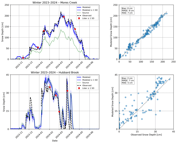
Caleb G. Pan, Jeremy Johnston, Jennifer M. Jacobs, and Shad O'Neel
The Cryosphere, 20, 3759–3781, https://doi.org/10.5194/tc-20-3759-2026, https://doi.org/10.5194/tc-20-3759-2026, 2026
Short summary
Short summary
We developed a simple method to turn a few airborne snow-mapping flights and one daily snow record into continuous maps showing how snow depth changes each day. Tested in Idaho and New Hampshire, the approach works well in both deep and shallow snow regions and helps plan when and how often to fly lidar surveys for the best results.
Jipeng Liu, Eunsang Cho, and Carrie M. Vuyovich
EGUsphere, https://doi.org/10.5194/egusphere-2026-986, https://doi.org/10.5194/egusphere-2026-986, 2026
Short summary
Short summary
We analyzed airborne LiDAR data from NASA’s SnowEx 2023 campaign to study snow depth in Alaska’s boreal forests. Comparing LiDAR to ground measurements, we found it captures general snow patterns well, though tall trees and slopes reduce accuracy. This approach can help improve snow surveys and better manage water resources in remote forested areas.
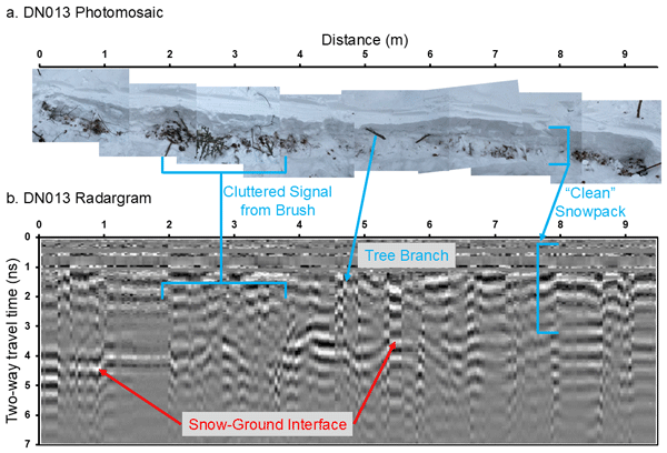
Kajsa Holland-Goon, Randall Bonnell, Daniel McGrath, W. Brad Baxter, Tate Meehan, Ryan Webb, Christopher F. Larsen, Hans-Peter Marshall, Megan Mason, and Carrie Vuyovich
The Cryosphere, 20, 2169–2179, https://doi.org/10.5194/tc-20-2169-2026, https://doi.org/10.5194/tc-20-2169-2026, 2026
Short summary
Short summary
As part of the NASA SnowEx23 campaign, we conducted detailed snowpack experiments in Alaska's boreal forests and Arctic tundra. We collected ground-penetrating radar measurements of snow depth along 44 short transects. We then excavated the snowpack from below the transects and measured snow depth, noting any vegetation and void spaces. We used the detailed in situ measurements to evaluate uncertainties in ground-penetrating radar and airborne lidar methods for snow depth retrieval.
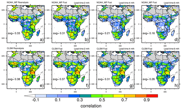
Bailing Li, Abheera Hazra, Amy McNally, Kimberly Slinski, Shraddhanand Shukla, and Weston Anderson
Hydrol. Earth Syst. Sci., 30, 1097–1115, https://doi.org/10.5194/hess-30-1097-2026, https://doi.org/10.5194/hess-30-1097-2026, 2026
Short summary
Short summary
Accurate prediction of terrestrial water storage (TWS) changes is essential for disaster response. This study evaluates TWS forecast skill over Africa using observations from the Gravity Recovery and Climate Experiment (GRACE). Results show that the NASA Catchment Land Surface Model (CLSM) outperforms Noah with Multi-Parameterization (Noah-MP) across 1-6 months lead times, owing to more accurate reanalysis-based initial conditions and stronger representation of TWS interannual variability.
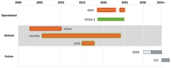
Zachary Fair, Carrie Vuyovich, Thomas Neumann, Justin Pflug, David Shean, Ellyn M. Enderlin, Karina Zikan, Hannah Besso, Jessica Lundquist, Cesar Deschamps-Berger, and Désirée Treichler
The Cryosphere, 19, 5671–5691, https://doi.org/10.5194/tc-19-5671-2025, https://doi.org/10.5194/tc-19-5671-2025, 2025
Short summary
Short summary
Lidar is commonly used to measure snow over global water reservoirs. However, ground-based and airborne lidar surveys are expensive, so satellite-based methods are needed. In this review, we outline the latest research using satellite-based lidar to monitor snow. Best practices for lidar-based snow monitoring are given, as is a discussion on challenges in this field of research.
Mahsa Moradi, Andrew G. Fleming, Adam Hunsaker, and Jennifer M. Jacobs
EGUsphere, https://doi.org/10.5194/egusphere-2025-4371, https://doi.org/10.5194/egusphere-2025-4371, 2025
Short summary
Short summary
Images from Unoccupied aerial systems (UAS) allow us to map snow more accurately, especially where snow is shallow and does not last long. We used UAS with visible imagery and tested different methods of mapping snow (including a few machine learning methods) in open areas in southern New Hampshire, USA. We found that using the full color information gives the most reliable results. We showed how UAS surveys can be planned to create accurate snow maps, helping track snow in changing conditions.
Eunsang Cho, Megan Verfaillie, Jennifer M. Jacobs, Adam G. Hunsaker, Franklin B. Sullivan, Michael Palace, and Cameron Wagner
Hydrol. Earth Syst. Sci., 29, 4539–4556, https://doi.org/10.5194/hess-29-4539-2025, https://doi.org/10.5194/hess-29-4539-2025, 2025
Short summary
Short summary
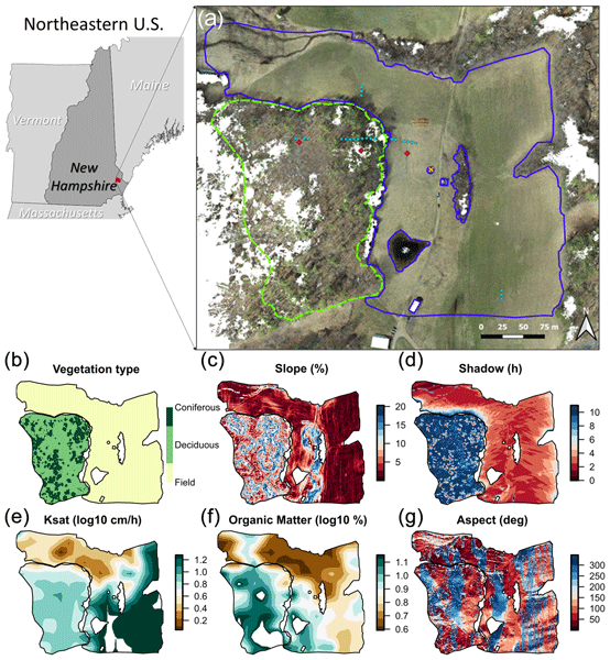
Unpiloted aerial system (UAS) lidar and structure-from-motion (SfM) photogrammetry effectively map high-resolution snow depths. Our study found that UAS lidar outperformed SfM, particularly in capturing stable snow distribution patterns. Vegetation type was the primary factor influencing snow depth across forest and field areas, reflecting soil variables, such as organic matter. When analyzed separately, slope and forest canopy shadowing played key roles.
Edward H. Bair, Dar A. Roberts, David R. Thompson, Philip G. Brodrick, Brenton A. Wilder, Niklas Bohn, Christopher J. Crawford, Nimrod Carmon, Carrie M. Vuyovich, and Jeff Dozier
The Cryosphere, 19, 2315–2320, https://doi.org/10.5194/tc-19-2315-2025, https://doi.org/10.5194/tc-19-2315-2025, 2025
Short summary
Short summary
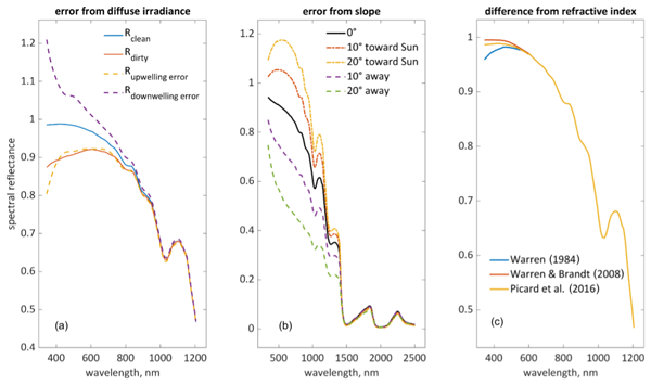
Key to the success of future satellite missions is understanding snowmelt in our warming climate, as this has implications for nearly 2 billion people. An obstacle is that an artifact, called the hook, is often mistaken for soot or dust. Instead, it is caused by three amplifying effects: (1) background reflectance that is too dark, (2) an assumption of level terrain, and (3) differences in optical constants of ice. Sensor calibration and directional effects may also contribute. Solutions are presented.
Colleen Mortimer, Lawrence Mudryk, Eunsang Cho, Chris Derksen, Mike Brady, and Carrie Vuyovich
The Cryosphere, 18, 5619–5639, https://doi.org/10.5194/tc-18-5619-2024, https://doi.org/10.5194/tc-18-5619-2024, 2024
Short summary
Short summary
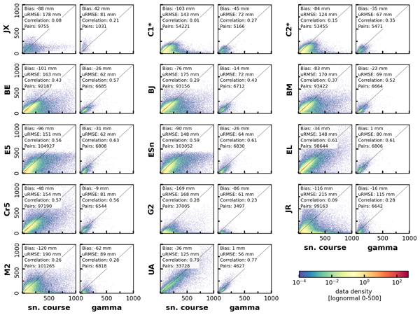
Ground measurements of snow water equivalent (SWE) are vital for understanding the accuracy of large-scale estimates from satellites and climate models. We compare two types of measurements – snow courses and airborne gamma SWE estimates – and analyze how measurement type impacts the accuracy assessment of gridded SWE products. We use this analysis to produce a combined reference SWE dataset for North America, applicable for future gridded SWE product evaluations and other applications.
Justin M. Pflug, Melissa L. Wrzesien, Sujay V. Kumar, Eunsang Cho, Kristi R. Arsenault, Paul R. Houser, and Carrie M. Vuyovich
Hydrol. Earth Syst. Sci., 28, 631–648, https://doi.org/10.5194/hess-28-631-2024, https://doi.org/10.5194/hess-28-631-2024, 2024
Short summary
Short summary
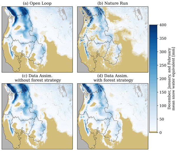
Estimates of 250 m of snow water equivalent in the western USA and Canada are improved by assimilating observations representative of a snow-focused satellite mission with a land surface model. Here, by including a gap-filling strategy, snow estimates could be improved in forested regions where remote sensing is challenging. This approach improved estimates of winter maximum snow water volume to within 4 %, on average, with persistent improvements to both spring snow and runoff in many regions.
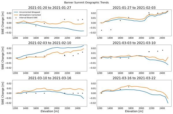
Zachary Hoppinen, Shadi Oveisgharan, Hans-Peter Marshall, Ross Mower, Kelly Elder, and Carrie Vuyovich
The Cryosphere, 18, 575–592, https://doi.org/10.5194/tc-18-575-2024, https://doi.org/10.5194/tc-18-575-2024, 2024
Short summary
Short summary
We used changes in radar echo travel time from multiple airborne flights to estimate changes in snow depths across Idaho for two winters. We compared our radar-derived retrievals to snow pits, weather stations, and a 100 m resolution numerical snow model. We had a strong Pearson correlation and root mean squared error of 10 cm relative to in situ measurements. Our retrievals also correlated well with our model, especially in regions of dry snow and low tree coverage.
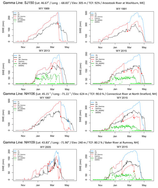
Eunsang Cho, Yonghwan Kwon, Sujay V. Kumar, and Carrie M. Vuyovich
Hydrol. Earth Syst. Sci., 27, 4039–4056, https://doi.org/10.5194/hess-27-4039-2023, https://doi.org/10.5194/hess-27-4039-2023, 2023
Short summary
Short summary
An airborne gamma-ray remote-sensing technique provides reliable snow water equivalent (SWE) in a forested area where remote-sensing techniques (e.g., passive microwave) typically have large uncertainties. Here, we explore the utility of assimilating the gamma snow data into a land surface model to improve the modeled SWE estimates in the northeastern US. Results provide new insights into utilizing the gamma SWE data for enhanced land surface model simulations in forested environments.
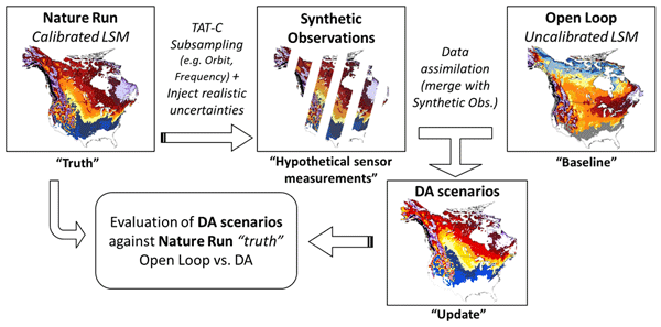
Eunsang Cho, Carrie M. Vuyovich, Sujay V. Kumar, Melissa L. Wrzesien, and Rhae Sung Kim
The Cryosphere, 17, 3915–3931, https://doi.org/10.5194/tc-17-3915-2023, https://doi.org/10.5194/tc-17-3915-2023, 2023
Short summary
Short summary
As a future snow mission concept, active microwave sensors have the potential to measure snow water equivalent (SWE) in deep snowpack and forested environments. We used a modeling and data assimilation approach (a so-called observing system simulation experiment) to quantify the usefulness of active microwave-based SWE retrievals over western Colorado. We found that active microwave sensors with a mature retrieval algorithm can improve SWE simulations by about 20 % in the mountainous domain.
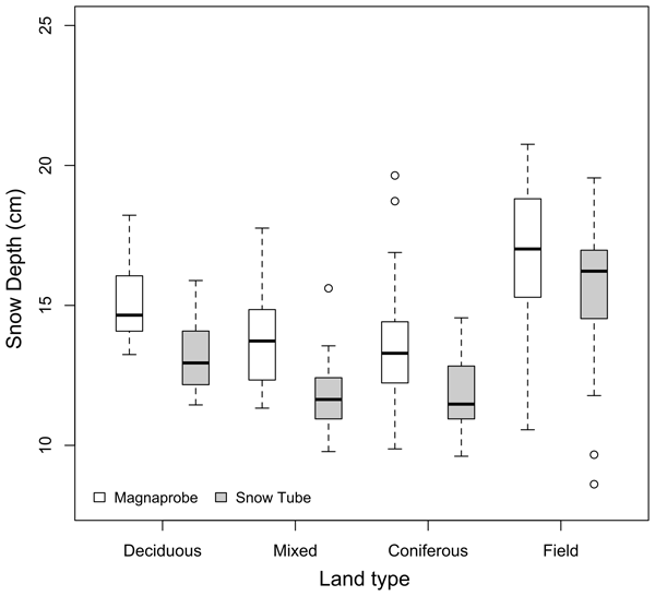
Holly Proulx, Jennifer M. Jacobs, Elizabeth A. Burakowski, Eunsang Cho, Adam G. Hunsaker, Franklin B. Sullivan, Michael Palace, and Cameron Wagner
The Cryosphere, 17, 3435–3442, https://doi.org/10.5194/tc-17-3435-2023, https://doi.org/10.5194/tc-17-3435-2023, 2023
Short summary
Short summary
This study compares snow depth measurements from two manual instruments in a field and forest. Snow depths measured using a magnaprobe were typically 1 to 3 cm deeper than those measured using a snow tube. These differences were greater in the forest than in the field.

Eunsang Cho, Carrie M. Vuyovich, Sujay V. Kumar, Melissa L. Wrzesien, Rhae Sung Kim, and Jennifer M. Jacobs
Hydrol. Earth Syst. Sci., 26, 5721–5735, https://doi.org/10.5194/hess-26-5721-2022, https://doi.org/10.5194/hess-26-5721-2022, 2022
Short summary
Short summary
While land surface models are a common approach for estimating macroscale snow water equivalent (SWE), the SWE accuracy is often limited by uncertainties in model physics and forcing inputs. In this study, we found large underestimations of modeled SWE compared to observations. Precipitation forcings and melting physics limitations dominantly contribute to the SWE underestimations. Results provide insights into prioritizing strategies to improve the SWE simulations for hydrologic applications.
Leung Tsang, Michael Durand, Chris Derksen, Ana P. Barros, Do-Hyuk Kang, Hans Lievens, Hans-Peter Marshall, Jiyue Zhu, Joel Johnson, Joshua King, Juha Lemmetyinen, Melody Sandells, Nick Rutter, Paul Siqueira, Anne Nolin, Batu Osmanoglu, Carrie Vuyovich, Edward Kim, Drew Taylor, Ioanna Merkouriadi, Ludovic Brucker, Mahdi Navari, Marie Dumont, Richard Kelly, Rhae Sung Kim, Tien-Hao Liao, Firoz Borah, and Xiaolan Xu
The Cryosphere, 16, 3531–3573, https://doi.org/10.5194/tc-16-3531-2022, https://doi.org/10.5194/tc-16-3531-2022, 2022
Short summary
Short summary
Snow water equivalent (SWE) is of fundamental importance to water, energy, and geochemical cycles but is poorly observed globally. Synthetic aperture radar (SAR) measurements at X- and Ku-band can address this gap. This review serves to inform the broad snow research, monitoring, and application communities about the progress made in recent decades to move towards a new satellite mission capable of addressing the needs of the geoscience researchers and users.
Holly Proulx, Jennifer M. Jacobs, Elizabeth A. Burakowski, Eunsang Cho, Adam G. Hunsaker, Franklin B. Sullivan, Michael Palace, and Cameron Wagner
The Cryosphere Discuss., https://doi.org/10.5194/tc-2022-7, https://doi.org/10.5194/tc-2022-7, 2022
Manuscript not accepted for further review
Short summary
Short summary
This study compares snow depth measurements from two manual instruments and an airborne platform in a field and forest. The manual instruments’ snow depths differed by 1 to 3 cm. The airborne measurements , which do not penetrate the leaf litter, were consistently shallower than either manual instrument. When combining airborne snow depth maps with manual density measurements, corrections may be required to create unbiased maps of snow properties.
Cited articles
Abolafia-Rosenzweig, R., He, C., Lin, T. S., Barlage, M., and Rittger, K.: Improved cross-scale snow cover simulations by developing a scale-aware ground snow cover fraction parameterization in the Noah-MP land surface model, J. Adv. Model. Earth Sy., 17, e2024MS004704, https://doi.org/10.1029/2024MS004704, 2025.
Abolafia-Rosenzweig, R., He, C., Ikeda, K., Liu, C., Lin, T.-S., Barlage, M., Xue, L., Rasouli, K., Zhang, Y., Newman, A., and Dudhia, J.: Revisiting snow water equivalent bias in the Noah-MP land surface model in the western US, Water Resour. Res., 62, e2025WR042586, https://doi.org/10.1029/2025WR042586, 2026.
Abramowitz, G., Leuning, R., Clark, M., and Pitman, A.: Evaluating the performance of land surface models, J. Climate, 21, 5468–5481, https://doi.org/10.1175/2008JCLI2378.1, 2008.
Agnihotri, J., Behrangi, A., Tavakoly, A., Geheran, M., Farmani, M. A., and Niu, G.-Y.: Higher frozen soil permeability represented in a hydrological model improves spring streamflow prediction from river basin to continental scales, Water Resour. Res., 59, e2022WR033075, https://doi.org/10.1029/2022WR033075, 2023.
Ahiablame, L., Sheshukov, A. Y., Rahmani, V., and Moriasi, D.: Annual baseflow variations as influenced by climate variability and agricultural land use change in the Missouri River Basin, J. Hydrol., 551, 188–202, https://doi.org/10.1016/j.jhydrol.2017.05.055, 2017.
Alfieri, L., Burek, P., Dutra, E., Krzeminski, B., Muraro, D., Thielen, J., and Pappenberger, F.: GloFAS – global ensemble streamflow forecasting and flood early warning, Hydrol. Earth Syst. Sci., 17, 1161–1175, https://doi.org/10.5194/hess-17-1161-2013, 2013.
Barnett, T. P., Adam, J. C., and Lettenmaier, D. P.: Potential impacts of a warming climate on water availability in snow dominated regions, Nature, 438, 303–309, https://doi.org/10.1038/nature04141, 2005.
Barnhart, T. B., Tague, C. L., and Molotch, N. P.: The counteracting effects of snowmelt rate and timing on runoff, Water Resour. Res., 56, e2019WR026634, https://doi.org/10.1029/2019WR026634, 2020.
Beck, H. E., Zimmermann, N. E., McVicar, T. R., Vergopolan, N., Berg, A., and Wood, E. F.: Present and future Köppen–Geiger climate classification maps at 1 km resolution, Sci. Data, 5, 180214, https://doi.org/10.1038/sdata.2018.214, 2018.
Broxton, P., Zeng, X., and Dawson, N.: Daily 4 km gridded SWE and snow depth from assimilated in-situ and modeled data over the conterminous US, version 1, NASA National Snow and Ice Data Center Distributed Active Archive Center (DAAC) [data set], https://doi.org/10.5067/0GGPB220EX6A, 2019.
Brutsaert, W.: Evaporation into the atmosphere: Theory, Reidel, Dordrecht, Holland, 299 pp., ISBN 9027712476, 1982.
Cai, X., Yang, Z. L., David, C. H., Niu, G. Y., and Rodell, M.: Hydrological evaluation of the Noah-MP land surface model for the Mississippi River Basin, J. Geophys. Res.-Atmos., 119, 23–38, https://doi.org/10.1002/2013JD020792, 2014.
Cao, X., Zhang, G., Chen, Y., Li, H., Li, J., Di, Y., and Cai, X.: Optimization of snow-related processes in Noah-MP land surface model over the mid-latitudes of Asian region, Atmos. Res., 311, 107711, https://doi.org/10.1016/j.atmosres.2024.107711, 2024.
Carroll, R. W., Deems, J. S., Niswonger, R., Schumer, R., and Williams, K. H.: The importance of interflow to groundwater recharge in a snowmelt-dominated headwater basin, Geophys. Res. Lett., 46, 5899–5908, https://doi.org/10.1029/2019GL082447, 2019.
Chang, M., Liao, W., Wang, X., Zhang, Q., Chen, W., Wu, Z., and Hu, Z.: An optimal ensemble of the Noah-MP land surface model for simulating surface heat fluxes over a typical subtropical forest in South China, Agr. Forest Meteorol., 281, 107815, https://doi.org/10.1016/j.agrformet.2019.107815, 2020.
Chen, F., Janjić, Z., and Mitchell, K.: Impact of atmospheric surface-layer parameterizations in the new land-surface scheme of the NCEP mesoscale Eta model, Bound.-Lay. Meteorol., 85, 391–421, https://doi.org/10.1023/A:1000531001463, 1997.
Cho, E., Cho, E., Vuyovich, C., Li, B., and Jacobs, J.: Data for: Basin-scale Evaluation of the Noah-MP Land Surface Model for Runoff and Snow Generation in the Missouri River Basin: Insights and Recommendations for Parameterization Scheme Selection, Zenodo [data set], https://doi.org/10.5281/zenodo.17519636, 2025.
Cho, E., Kwon, Y., Kumar, S. V., and Vuyovich, C. M.: Assimilation of airborne gamma observations provides utility for snow estimation in forested environments, Hydrol. Earth Syst. Sci., 27, 4039–4056, https://doi.org/10.5194/hess-27-4039-2023, 2023.
Cho, E., McCrary, R. R., and Jacobs, J. M.: Future changes in snowpack, snowmelt, and runoff potential extremes over North America, Geophys. Res. Lett., 48, e2021GL094985, https://doi.org/10.1029/2021GL094985, 2021.
Cinkus, G., Mazzilli, N., Jourde, H., Wunsch, A., Liesch, T., Ravbar, N., Chen, Z., and Goldscheider, N.: When best is the enemy of good – critical evaluation of performance criteria in hydrological models, Hydrol. Earth Syst. Sci., 27, 2397–2411, https://doi.org/10.5194/hess-27-2397-2023, 2023.
Clapp, R. B. and Hornberger, G. M.: Empirical equations for some soil hydraulic properties, Water Resour. Res., 14, 601–604, https://doi.org/10.1029/WR014i004p00601, 1978.
Cortés-Salazar, N., Vásquez, N., Mizukami, N., Mendoza, P. A., and Vargas, X.: To what extent does river routing matter in hydrological modeling?, Hydrol. Earth Syst. Sci., 27, 3505–3524, https://doi.org/10.5194/hess-27-3505-2023, 2023.
Cosgrove, B., Gochis, D., Flowers, T., Dugger, A., Ogden, F., Graziano, T., Clark, E., Cabell, R., Casiday, N., Cui, Z., and Eicher, K.: NOAA's National Water Model: Advancing operational hydrology through continental-scale modeling, J. Am. Water Resour. As., 60, 247–272, https://doi.org/10.1111/1752-1688.13184, 2024.
Cuntz, M., Mai, J., Samaniego, L., Clark, M., Wulfmeyer, V., Branch, O., Attinger, S., and Thober, S.: The impact of standard and hard-coded parameters on the hydrologic fluxes in the Noah-MP land surface model, J. Geophys. Res.-Atmos., 121, 10676–10700, https://doi.org/10.1002/2016JD025097, 2016.
Darcy, H.: Les fontaines publiques de la ville de Dijon, Dalmont, Paris, France, 647 pp., 1856.
Ek, M. B., Mitchell, K. E., Lin, Y., Rogers, E., Grunmann, P., Koren, V., Gayno, G., and Tarpley, J. D.: Implementation of Noah land surface model advances in the National Centers for Environmental Prediction operational mesoscale Eta model, J. Geophys. Res.-Atmos., 108, 8851, https://doi.org/10.1029/2002JD003296, 2003.
Falcone, J. A.: GAGES-II: Geospatial attributes of gages for evaluating streamflow, US Geological Survey, Reston, Virginia, USA, https://doi.org/10.3133/70046617, 2011.
Fisher, R. A. and Koven, C. D.: Perspectives on the future of land surface models and the challenges of representing complex terrestrial systems, J. Adv. Model. Earth Sy., 12, e2018MS001453, https://doi.org/10.1029/2018MS001453, 2020.
Francis, B. and Melliger, J.: 2019 Missouri River Basin Historic Flood Event, J. Dam Saf., 18, 14–24, 2021.
Gan, Y., Liang, X. Z., Duan, Q., Chen, F., Li, J., and Zhang, Y.: Assessment and reduction of the physical parameterization uncertainty for Noah-MP land surface model, Water Resour. Res., 55, 5518–5538, https://doi.org/10.1029/2019WR024814, 2019.
Gottlieb, A. R. and Mankin, J. S.: Evidence of human influence on Northern Hemisphere snow loss, Nature, 625, 293–300, https://doi.org/10.1038/s41586-023-06794-y, 2024.
Graybeal, D. Y. and Leathers, D. J.: Snowmelt-related flood risk in Appalachia: First estimates from a historical snow climatology, J. Appl. Meteorol. Clim., 45, 178–193, https://doi.org/10.1175/JAM2330.1, 2006.
Gupta, H. V., Kling, H., Yilmaz, K. K., and Martinez, G. F.: Decomposition of the mean squared error and NSE performance criteria: Implications for improving hydrological modelling, J. Hydrol., 377, 80–91, https://doi.org/10.1016/j.jhydrol.2009.08.003, 2009.
Hamitouche, M., Fosser, G., Anav, A., He, C., and Lin, T.-S.: Impact of runoff schemes on global flow discharge: a comprehensive analysis using the Noah-MP and CaMa-Flood models, Hydrol. Earth Syst. Sci., 29, 1221–1240, https://doi.org/10.5194/hess-29-1221-2025, 2025.
Hao, Z., Hao, F., Xia, Y., Singh, V. P., Hong, Y., Shen, X., and Ouyang, W.: A statistical method for categorical drought prediction based on NLDAS-2, J. Appl. Meteorol. Clim., 55, 1049–1061, https://doi.org/10.1175/JAMC-D-15-0200.1, 2016.
He, C., Valayamkunnath, P., Barlage, M., Chen, F., Gochis, D., Cabell, R., Schneider, D., Ikeda, K., Lin, T. S., Castro, C., Bruyere, C., Ahijevych, D., Rasmussen, R., Jin, J., Trahan, S., Neale, R., and Ek, M.: The community Noah-MP land surface modeling system technical description version 5.0, NCAR Technical Note NCAR/TN-575+STR, National Center for Atmospheric Research, Boulder, CO, USA, https://doi.org/10.5065/ew8g-yr95, 2023.
Hong, S., Yu, X., Park, S. K., Choi, Y.-S., and Myoung, B.: Assessing optimal set of implemented physical parameterization schemes in a multi-physics land surface model using genetic algorithm, Geosci. Model Dev., 7, 2517–2529, https://doi.org/10.5194/gmd-7-2517-2014, 2014.
Hu, W., Ma, W., Yang, Z. L., Ma, Y., and Xie, Z.: Sensitivity analysis of the Noah-MP land surface model for soil hydrothermal simulations over the Tibetan Plateau, J. Adv. Model. Earth Sy., 15, e2022MS003136, https://doi.org/10.1029/2022MS003136, 2023.
Huntington, J. L. and Niswonger, R. G.: Role of surface-water and groundwater interactions on projected summertime streamflow in snow dominated regions: An integrated modeling approach, Water Resour. Res., 48, W11524, https://doi.org/10.1029/2012WR012319, 2012.
Jordan, Y. C., Ghulam, A., and Herrmann, R. B.: Floodplain ecosystem response to climate variability and land-cover and land-use change in Lower Missouri River basin, Landscape Ecol., 27, 843–857, https://doi.org/10.1007/s10980-012-9748-x, 2012.
Knoben, W. J. M., Freer, J. E., and Woods, R. A.: Technical note: Inherent benchmark or not? Comparing Nash–Sutcliffe and Kling–Gupta efficiency scores, Hydrol. Earth Syst. Sci., 23, 4323–4331, https://doi.org/10.5194/hess-23-4323-2019, 2019.
Koppa, A., Rains, D., Hulsman, P., Poyatos, R., and Miralles, D. G.: A deep learning-based hybrid model of global terrestrial evaporation, Nat. Commun., 13, 1912, https://doi.org/10.1038/s41467-022-29543-7, 2022.
Koren, V., Schaake, J., Mitchell, K., Duan, Q. Y., Chen, F., and Baker, J. M.: A parameterization of snowpack and frozen ground intended for NCEP weather and climate models, J. Geophys. Res.-Atmos., 104, 19569–19585, https://doi.org/10.1029/1999JD900232, 1999.
Kumar, S. V., Peters-Lidard, C. D., Tian, Y., Houser, P. R., Geiger, J., Olden, S., Lighty, L., Eastman, J. L., Doty, B., Dirmeyer, P., Adams, J., Mitchell, K., Wood, E. F., and Sheffield, J.: Land information system: An interoperable framework for high resolution land surface modeling, Environ. Modell. Softw., 21, 1402–1415, https://doi.org/10.1016/j.envsoft.2005.07.004, 2006.
Kumar, S. V., Reichle, R. H., Peters-Lidard, C. D., Koster, R. D., Zhan, X., Crow, W. T., Eylander, J. B., and Houser, P. R.: A land surface data assimilation framework using the land information system: Description and applications, Adv. Water Resour., 31, 1419–1432, https://doi.org/10.1016/j.advwatres.2008.01.013, 2008.
Lapides, D. A., Hahm, W. J., Rempe, D. M., Whiting, J., and Dralle, D. N.: Causes of missing snowmelt following drought, Geophys. Res. Lett., 49, e2022GL100505, https://doi.org/10.1029/2022GL100505, 2022.
Li, B., Rodell, M., Peters-Lidard, C., Erlingis, J., Kumar, S., and Mocko, D.: Groundwater recharge estimated by land surface models: An evaluation in the conterminous United States, J. Hydrometeorol., 22, 499–522, https://doi.org/10.1175/JHM-D-20-0130.1, 2021.
Li, J., Miao, C., Zhang, G., Fang, Y. H., Shangguan, W., and Niu, G. Y.: Global evaluation of the Noah-MP land surface model and suggestions for selecting parameterization schemes, J. Geophys. Res.-Atmos., 127, e2021JD035753, https://doi.org/10.1029/2021JD035753, 2022.
Liu, X., Chen, F., Barlage, M., Zhou, G., and Niyogi, D.: Noah-MP-Crop: Introducing dynamic crop growth in the Noah-MP land surface model, J. Geophys. Res.-Atmos., 121, 13953–13972, https://doi.org/10.1002/2016JD025597, 2016.
Liu, Y., Fernández-Ortega, J., Mudarra, M., and Hartmann, A.: Pitfalls and a feasible solution for using KGE as an informal likelihood function in MCMC methods: DREAM(ZS) as an example, Hydrol. Earth Syst. Sci., 26, 5341–5355, https://doi.org/10.5194/hess-26-5341-2022, 2022.
Ma, N., Niu, G. Y., Xia, Y., Cai, X., Zhang, Y., Ma, Y., and Fang, Y.: A systematic evaluation of Noah-MP in simulating land–atmosphere energy, water, and carbon exchanges over the continental United States, J. Geophys. Res.-Atmos., 122, 12245–12268, https://doi.org/10.1002/2017JD027597, 2017.
Maina, F. Z., Rosen, D., Abbaszadeh, P., Yang, C., Kumar, S. V., Rodell, M., and Maxwell, R.: Integrating the interconnections between groundwater and land surface processes through the coupled NASA land information system and ParFlow environment, J. Adv. Model. Earth Sy., 17, e2024MS004415, https://doi.org/10.1029/2024MS004415, 2025.
Miralles, D. G., Bonte, O., Koppa, A., Baez-Villanueva, O. M., Tronquo, E., Zhong, F., Beck, H. E., Hulsman, P., Dorigo, W., Verhoest, N. E. C., and Haghdoost, S.: GLEAM4: global land evaporation and soil moisture dataset at 0.1° resolution from 1980 to near present, Sci. Data, 12, 416, https://doi.org/10.1038/s41597-025-04610-y, 2025.
Musselman, K. N., Lehner, F., Ikeda, K., Clark, M. P., Prein, A. F., Liu, C., Barlage, M., and Rasmussen, R.: Projected increases and shifts in rain-on-snow flood risk over western North America, Nat. Clim. Change, 8, 808–812, https://doi.org/10.1038/s41558-018-0236-4, 2018.
NCEI (National Centers for Environmental Information): Extreme Wetness of 2019 Sets Records, National Oceanic and Atmospheric Administration, Silver Spring, Maryland, USA, https://www.ncei.noaa.gov/news/extreme-wetness-2019-sets-records (last access: 16 July 2025), 2020.
Nearing, G. S., Mocko, D. M., Peters-Lidard, C. D., Kumar, S. V., and Xia, Y.: Benchmarking NLDAS-2 soil moisture and evapotranspiration to separate uncertainty contributions, J. Hydrometeorol., 17, 745–759, https://doi.org/10.1175/JHM-D-15-0063.1, 2016.
Niu, G. Y. and Yang, Z. L.: Effects of frozen soil on snowmelt runoff and soil water storage at a continental scale, J. Hydrometeorol., 7, 937–952, https://doi.org/10.1175/JHM538.1, 2006.
Niu, G. Y., Yang, Z. L., Dickinson, R. E., and Gulden, L. E.: A simple TOPMODEL-based runoff parameterization (SIMTOP) for use in global climate models, J. Geophys. Res.-Atmos., 110, D21106, https://doi.org/10.1029/2005JD006111, 2005.
Niu, G. Y., Yang, Z. L., Dickinson, R. E., Gulden, L. E., and Su, H.: Development of a simple groundwater model for use in climate models and evaluation with Gravity Recovery and Climate Experiment data, J. Geophys. Res.-Atmos., 112, D07103, https://doi.org/10.1029/2006JD007522, 2007.
Niu, G.-Y., Yang, Z.-L., Mitchell, K. E., Chen, F., Ek, M. B., Barlage, M., Kumar, A., Manning, K., Niyogi, D., Rosero, E., Tewari, M., and Xia, Y.: The community Noah land surface model with multiparameterization options (Noah-MP): 1. Model description and evaluation with local-scale measurements, J. Geophys. Res.-Atmos., 116, D12109, https://doi.org/10.1029/2010JD015139, 2011.
Overgaard, J., Rosbjerg, D., and Butts, M. B.: Land-surface modelling in hydrological perspective – a review, Biogeosciences, 3, 229–241, https://doi.org/10.5194/bg-3-229-2006, 2006.
Pascolini-Campbell, M. and Reager, J. T.: An Investigation of the Spatial and Temporal Characteristics of Extreme Dry and Wet Events across NLDAS-2 Models, J. Hydrometeorol., 25, 239–255, https://doi.org/10.1175/JHM-D-23-0038.1, 2024.
Peters-Lidard, C. D., Houser, P. R., Tian, Y., Kumar, S. V., Geiger, J., Olden, S., Lighty, L., Doty, B., Dirmeyer, P., Adams, J., Mitchell, K., Wood, E. F., and Sheffield, J.: High-performance Earth system modeling with NASA/GSFC's Land Information System, Innovations in Systems and Software Engineering, 3, 157–165, https://doi.org/10.1007/s11334-007-0028-x, 2007.
Qiao, L., Pan, Z., Herrmann, R. B., and Hong, Y.: Hydrological variability and uncertainty of lower Missouri River basin under changing climate, J. Am. Water Resour. As., 50, 246–260, https://doi.org/10.1111/jawr.12126, 2014.
Qin, H., Thompson, M. R., Garcia, L. J., and Patel, S. K.: Extreme value snow water equivalent and snowmelt for hydrologic design, Water Resour. Res., 56, e2020WR028126, https://doi.org/10.1029/2020WR028126, 2020.
Shirzaei, M., Khoshmanesh, M., Ojha, C., Werth, S., Kerner, H., Carlson, G., Sherpa, S. F., Naghibi, F., and Lee, J. C.: Persistent impact of spring floods on crop loss in US Midwest, Weather and Climate Extremes, 34, 100392, https://doi.org/10.1016/j.wace.2021.100392, 2021.
Siirila-Woodburn, E. R., Rhoades, A. M., Hatchett, B. J., Huning, L. S., Szinai, J., Tague, C., Nico, P. S., Feldman, D. R., Jones, A. D., Collins, W. D., and Kaatz, L.: A low-to-no snow future and its impacts on water resources in the western United States, Nat. Rev. Earth Environ., 2, 800–819, https://doi.org/10.1038/s43017-021-00219-y, 2021.
Stadnyk, T., Dow, K., Wazney, L., and Blais, E. L.: The 2011 flood event in the Red River Basin: Causes, assessment and damages, Can. Water Resour. J., 41, 65–73, https://doi.org/10.1080/07011784.2015.1008048, 2016.
Sthapit, E., Lakhankar, T., Hughes, M., Khanbilvardi, R., Cifelli, R., Mahoney, K., Martin, R., Shrestha, R., and Rafieeinasab, A.: Evaluation of snow and streamflows using Noah-MP and WRF-hydro models in Aroostook River basin, Maine, Water, 14, 2145, https://doi.org/10.3390/w14142145, 2022.
Sturm, M. and Liston, G. E.: Revisiting the global seasonal snow classification: An updated dataset for earth system applications, J. Hydrometeorol., 22, 2917–2938, https://doi.org/10.1175/JHM-D-21-0070.1, 2021.
Su, L., Lettenmaier, D. P., Pan, M., and Bass, B.: Improving runoff simulation in the Western United States with Noah-MP and VIC models, Hydrol. Earth Syst. Sci., 28, 3079–3097, https://doi.org/10.5194/hess-28-3079-2024, 2024.
USACE (US Army Corps of Engineers): National Inventory of Dams, US Army Corps of Engineers, Washington, D.C., USA, https://nid.sec.usace.army.mil/nid/#/ (last access: 3 March 2026), 2021.
USGS (US Geological Survey): USGS hydro-climatic data network 2009 (HCDN-2009), US Geological Survey, Reston, Virginia, USA, https://doi.org/10.3133/fs20123047, 2012.
Velasquez, N., Quintero, F., Koya, S. R., Roy, T., and Mantilla, R.: Snow-detonated floods: Assessment of the US midwest march 2019 event, J. Hydrol.-Reg. Stud., 47, 101387, https://doi.org/10.1016/j.ejrh.2023.101387, 2023.
Vormoor, K., Lawrence, D., Schlichting, L., Wilson, D., and Wong, W. K.: Evidence for changes in the magnitude and frequency of observed rainfall vs. snowmelt driven floods in Norway, J. Hydrol., 538, 33–48, https://doi.org/10.1016/j.jhydrol.2016.03.066, 2016.
Wise, E. K., Woodhouse, C. A., McCabe, G. J., Pederson, G. T., and St.-Jacques, J. M.: Hydroclimatology of the Missouri River basin, J. Hydrometeorol., 19, 161–182, https://doi.org/10.1175/JHM-D-17-0155.1, 2018.
Wood, A. W. and Lettenmaier, D. P.: A test bed for new seasonal hydrologic forecasting approaches in the western United States, B. Am. Meteorol. Soc., 87, 1699–1712, https://doi.org/10.1175/BAMS-87-12-1699, 2006.
Xia, Y., Mitchell, K., Ek, M., Sheffield, J., Cosgrove, B., Wood, E., Luo, L., Alonge, C., Wei, H., Meng, J., Livneh, B., Lettenmaier, D., Koren, V., Duan, Q., Mo, K., Fan, Y., and Mocko, D.: Continental-scale water and energy flux analysis and validation for the North American Land Data Assimilation System project phase 2 (NLDAS-2): 1. Intercomparison and application of model products, J. Geophys. Res.-Atmos., 117, D03109, https://doi.org/10.1029/2011JD016048, 2012a.
Xia, Y., Cosgrove, B. A., Mitchell, K. E., Peters-Lidard, C. D., Ek, M. B., Kumar, S., Mocko, D., and Wei, H.: Continental-scale water and energy flux analysis and validation for the North American Land Data Assimilation System project phase 2 (NLDAS-2): 2. Validation of model-simulated streamflow, J. Geophys. Res.-Atmos., 117, D03110, https://doi.org/10.1029/2011JD016051, 2012b.
Xia, Y., Peters-Lidard, C. D., Huang, M., Wei, H., and Ek, M.: Improved NLDAS-2 Noah-simulated hydrometeorological products with an interim run, Hydrol. Process., 29, 780–792, https://doi.org/10.1002/hyp.10190, 2014.
Xia, Y., Cosgrove, B. A., Mitchell, K. E., Peters-Lidard, C. D., Ek, M. B., Kumar, S., Mocko, D., Barlage, M., Livneh, B., Cai, X., and Wei, H.: Basin-scale assessment of the land surface energy budget in the National Centers for Environmental Prediction operational and research NLDAS-2 systems, J. Geophys. Res.-Atmos., 121, 196–220, https://doi.org/10.1002/2015JD023889, 2016.
Yang, K., Yang, J., Zhaoye, P., Zhang, F., Zhang, G., and Wang, C.: Optimization and validation of soil frozen–thawing parameterizations in Noah-MP, J. Geophys. Res.-Atmos., 128, e2022JD038217, https://doi.org/10.1029/2022JD038217, 2023.
Yang, Z.-L., Niu, G.-Y., Mitchell, K. E., Chen, F., Ek, M. B., Barlage, M., Longuevergne, L., Manning, K., Niyogi, D., Tewari, M., and Xia, Y.: The community Noah land surface model with multiparameterization options (Noah-MP): 2. Evaluation over global river basins, J. Geophys. Res.-Atmos., 116, D12110, https://doi.org/10.1029/2010JD015140, 2011.
Yin, J., Zhan, X., Barlage, M., Kumar, S., Fox, A., Albergel, C., Mahfouf, J.-F., Hain, C., and Liu, J.: Assimilation of blended satellite soil moisture data products to further improve Noah-MP model skills, J. Hydrol., 621, 129596, https://doi.org/10.1016/j.jhydrol.2023.129596, 2023.
You, Y., Huang, C., Gu, J., Li, H., Hao, X., and Hou, J.: Assessing snow simulation performance of typical combination schemes within Noah-MP in northern Xinjiang, China, J. Hydrol., 581, 124380, https://doi.org/10.1016/j.jhydrol.2019.124380, 2020.
Short summary
This study evaluated how alternative parameterization schemes in the Noah-Multiparameterization model affect snow and runoff in the Missouri River Basin. Simulations were compared with U.S. Geological Survey streamflow, University of Arizona snow water equivalent, and Global Land Evaporation Amsterdam Model evapotranspiration across 50 Hydro-Climate Data Network subbasins. As a result, we confirmed alternative schemes could improve groundwater, evapotranspiration, and runoff representation.
This study evaluated how alternative parameterization schemes in the Noah-Multiparameterization...


