
Articles | Volume 30, issue 15
https://doi.org/10.5194/hess-30-5049-2026
© Author(s) 2026. This work is distributed under
the Creative Commons Attribution 4.0 License.
the Creative Commons Attribution 4.0 License.
https://doi.org/10.5194/hess-30-5049-2026
© Author(s) 2026. This work is distributed under
the Creative Commons Attribution 4.0 License.
the Creative Commons Attribution 4.0 License.
Research article
| 
11 Aug 2026
Research article |
| 11 Aug 2026
| 11 Aug 2026
High resolution modelling of temporal and spatial dynamics in soil conditions in subarctic Finland using HydroBlocks model
Emma-Riikka Kokko
CORRESPONDING AUTHOR

Oulu Mining School, University of Oulu, Oulu, Finland
Nathaniel Chaney
Environmental and Civil Engineering Department, Duke University, Durham, NC, USA
Daniel Guyumus
Environmental and Civil Engineering Department, Duke University, Durham, NC, USA
Luiz Bacelar
Environmental and Civil Engineering Department, Duke University, Durham, NC, USA
Laura Torres-Rojas
Atmospheric and Oceanic Sciences, Princeton University, Princeton, NJ, USA
Jarkko Okkonen
Geological Survey of Finland, Kokkola, Finland
Related authors
Jarkko Okkonen, Christian Silbermann, Jere Remes, Dmitri Naumov, Nikita Afonin, Elena Kozlovskaya, Emma-Riikka Kokko, Kari Moisio, Tymofiy Gerasimov, and Thomas Nagel
EGUsphere, https://doi.org/10.5194/egusphere-2026-2611, https://doi.org/10.5194/egusphere-2026-2611, 2026
Preprint archived
Short summary
Short summary
Frost quakes are cracking events in freezing ground, traditionally linked to rapid freezing of soil without or little snow on the ground. This study shows they can also occur under thick snow cover, driven by quick temperature drops below −20 °C, changes in soil and ice content, and stress buildup. Results suggest multiple interacting processes causing frost quakes, highlighting the need for better models and experiments to assess risks in cold regions.

Nikita Afonin, Elena Kozlovskaya, Kari Moisio, Emma-Riikka Kokko, and Jarkko Okkonen
The Cryosphere, 18, 2223–2238, https://doi.org/10.5194/tc-18-2223-2024, https://doi.org/10.5194/tc-18-2223-2024, 2024
Short summary
Short summary
Our study shows that seismic events in the wetlands in Arctic and sub-Arctic areas are capable of producing ground motions strong enough to damage the infrastructures like roads and basements of buildings located at distances of several hundreds of metres from the wetlands. That is why this phenomenon deserves further studies.
Jarkko Okkonen, Christian Silbermann, Jere Remes, Dmitri Naumov, Nikita Afonin, Elena Kozlovskaya, Emma-Riikka Kokko, Kari Moisio, Tymofiy Gerasimov, and Thomas Nagel
EGUsphere, https://doi.org/10.5194/egusphere-2026-2611, https://doi.org/10.5194/egusphere-2026-2611, 2026
Preprint archived
Short summary
Short summary
Frost quakes are cracking events in freezing ground, traditionally linked to rapid freezing of soil without or little snow on the ground. This study shows they can also occur under thick snow cover, driven by quick temperature drops below −20 °C, changes in soil and ice content, and stress buildup. Results suggest multiple interacting processes causing frost quakes, highlighting the need for better models and experiments to assess risks in cold regions.
Chengcheng Xu, Elia Scudiero, Ray Anderson, and Nathaniel Chaney
SOIL, 12, 665–687, https://doi.org/10.5194/soil-12-665-2026, https://doi.org/10.5194/soil-12-665-2026, 2026
Short summary
Short summary
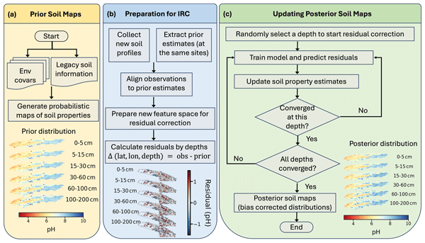
Accurate soil information is vital. This study developed a method to improve existing probabilistic soil maps, spatially continuous maps providing prior estimates, by correcting their probability distributions as new soil data emerges. By iteratively adjusting previous predictions, the method increases both accuracy and certainty of soil maps. Its application in California enhanced predictions for several soil properties. This method can be further used for more soil properties and regions.
Daniel Guyumus, Laura Torres-Rojas, Luiz Bacelar, Chengcheng Xu, and Nathaniel Chaney
Geosci. Model Dev., 19, 477–504, https://doi.org/10.5194/gmd-19-477-2026, https://doi.org/10.5194/gmd-19-477-2026, 2026
Short summary
Short summary
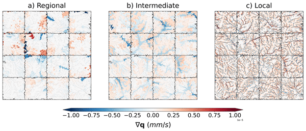
This study explores a new tiling scheme within the HydroBlocks Land Surface Model to represent local, regional and intermediate subsurface flow. Using high-resolution environmental data, the scheme defines parameterized flow units, enabling water and energy flux simulations. Compared against a benchmark simulation, the multiscale scheme demonstrates strong agreement in spatial mean, standard deviation, and temporal variability, showcasing its potential for large-scale hydrological simulation.
Wouter J. M. Knoben, Cyril Thébault, Kasra Keshavarz, Laura Torres-Rojas, Nathaniel W. Chaney, Alain Pietroniro, and Martyn P. Clark
Hydrol. Earth Syst. Sci., 29, 5791–5833, https://doi.org/10.5194/hess-29-5791-2025, https://doi.org/10.5194/hess-29-5791-2025, 2025
Short summary
Short summary
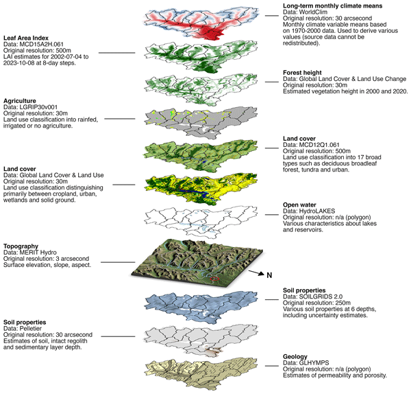
Many existing datasets for hydrologic analysis tend to treat catchments as single spatially homogeneous units focusing on daily data and typically do not support more complex models. This paper introduces a dataset that goes beyond this set-up by (1) providing data at a higher spatial and temporal resolution, (2) specifically considering the data requirements of all common hydrologic model types, and (3) using statistical summaries of the data aimed at quantifying spatial and temporal heterogeneity.
Minki Hong, Nathaniel Chaney, Sergey Malyshev, Enrico Zorzetto, Anthony Preucil, and Elena Shevliakova
Geosci. Model Dev., 18, 2275–2301, https://doi.org/10.5194/gmd-18-2275-2025, https://doi.org/10.5194/gmd-18-2275-2025, 2025
Short summary
Short summary
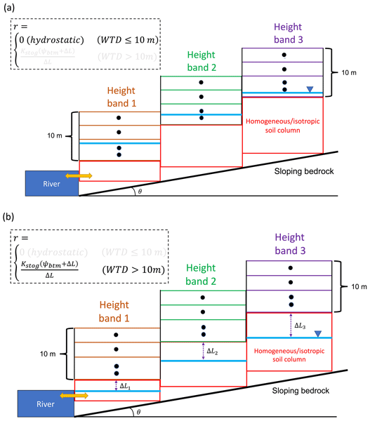
This study shows the significance of groundwater in resolving the coupled terrestrial water–energy cycle. LM4-SHARC (soil–hillslope aquifer–river continuum) describes the hillslope groundwater using its emergent properties, yielding noticeable improvements in soil moisture/temperature and groundwater discharge predictions. The implications of groundwater-mediated hydrologic interactions between hillslopes and streams need further exploration in the Earth system modeling community.
Rachael Lau, Carolina Seguí, Tyler Waterman, Nathaniel Chaney, and Manolis Veveakis
Nat. Hazards Earth Syst. Sci., 24, 3651–3661, https://doi.org/10.5194/nhess-24-3651-2024, https://doi.org/10.5194/nhess-24-3651-2024, 2024
Short summary
Short summary
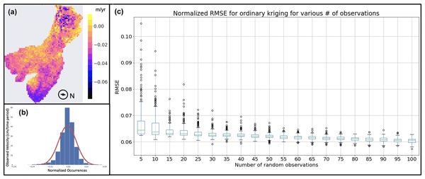
This work examines the use of interferometric synthetic-aperture radar (InSAR) alongside in situ borehole measurements to assess the stability of deep-seated landslides for the case study of El Forn (Andorra). Comparing InSAR with borehole data suggests a key trade-off between accuracy and precision for various InSAR resolutions. Spatial interpolation with InSAR informed how many remote observations are necessary to lower error in a remote sensing re-creation of ground motion over the landslide.
Nikita Afonin, Elena Kozlovskaya, Kari Moisio, Emma-Riikka Kokko, and Jarkko Okkonen
The Cryosphere, 18, 2223–2238, https://doi.org/10.5194/tc-18-2223-2024, https://doi.org/10.5194/tc-18-2223-2024, 2024
Short summary
Short summary
Our study shows that seismic events in the wetlands in Arctic and sub-Arctic areas are capable of producing ground motions strong enough to damage the infrastructures like roads and basements of buildings located at distances of several hundreds of metres from the wetlands. That is why this phenomenon deserves further studies.
Kirsten L. Findell, Zun Yin, Eunkyo Seo, Paul A. Dirmeyer, Nathan P. Arnold, Nathaniel Chaney, Megan D. Fowler, Meng Huang, David M. Lawrence, Po-Lun Ma, and Joseph A. Santanello Jr.
Geosci. Model Dev., 17, 1869–1883, https://doi.org/10.5194/gmd-17-1869-2024, https://doi.org/10.5194/gmd-17-1869-2024, 2024
Short summary
Short summary
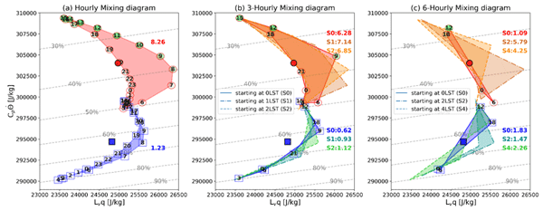
We outline a request for sub-daily data to accurately capture the process-level connections between land states, surface fluxes, and the boundary layer response. This high-frequency model output will allow for more direct comparison with observational field campaigns on process-relevant timescales, enable demonstration of inter-model spread in land–atmosphere coupling processes, and aid in targeted identification of sources of deficiencies and opportunities for improvement of the models.
Luiz Bacelar, Arezoo ReifeeiNasab, Nathaniel Chaney, and Ana Barros
EGUsphere, https://doi.org/10.5194/egusphere-2023-2088, https://doi.org/10.5194/egusphere-2023-2088, 2023
Preprint archived
Short summary
Short summary
The study explores a computationally efficient probabilistic precipitation forecast approach to generate multiple flood scenarios. It reveals the limitations in predicting flash floods accurately and the need for advanced ensemble methodologies to combine different sources of precipitation forecasts. It highlights the scale-dependency of flood predictions at higher spatial resolutions, shedding light on the relationship between river hydraulics and flood propagation in the river network.
Patricia Lawston-Parker, Joseph A. Santanello Jr., and Nathaniel W. Chaney
Hydrol. Earth Syst. Sci., 27, 2787–2805, https://doi.org/10.5194/hess-27-2787-2023, https://doi.org/10.5194/hess-27-2787-2023, 2023
Short summary
Short summary
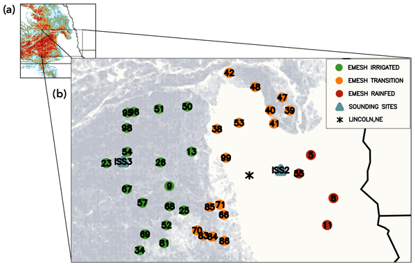
Irrigation has been shown to impact weather and climate, but it has only recently been considered in prediction models. Prescribing where (globally) irrigation takes place is important to accurately simulate its impacts on temperature, humidity, and precipitation. Here, we evaluated three different irrigation maps in a weather model and found that the extent and intensity of irrigated areas and their boundaries are important drivers of weather impacts resulting from human practices.
Enrico Zorzetto, Sergey Malyshev, Nathaniel Chaney, David Paynter, Raymond Menzel, and Elena Shevliakova
Geosci. Model Dev., 16, 1937–1960, https://doi.org/10.5194/gmd-16-1937-2023, https://doi.org/10.5194/gmd-16-1937-2023, 2023
Short summary
Short summary
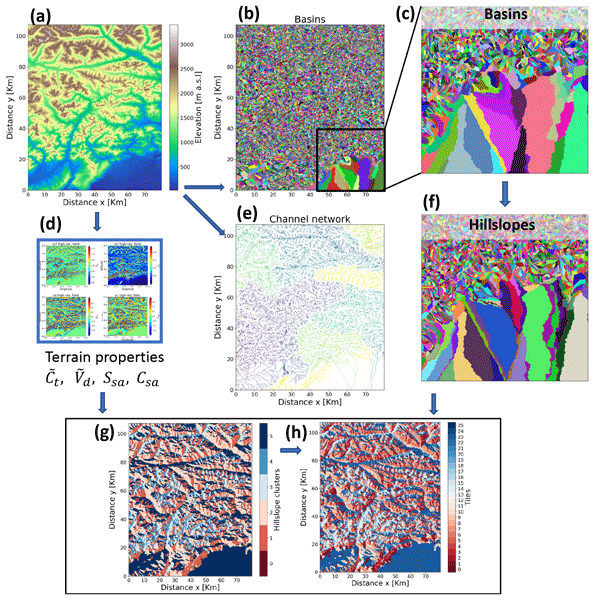
In this paper we develop a methodology to model the spatial distribution of solar radiation received by land over mountainous terrain. The approach is designed to be used in Earth system models, where coarse grid cells hinder the description of fine-scale land–atmosphere interactions. We adopt a clustering algorithm to partition the land domain into a set of homogeneous sub-grid
tiles, and for each tile we evaluate solar radiation received by land based on terrain properties.
Meng Huang, Po-Lun Ma, Nathaniel W. Chaney, Dalei Hao, Gautam Bisht, Megan D. Fowler, Vincent E. Larson, and L. Ruby Leung
Geosci. Model Dev., 15, 6371–6384, https://doi.org/10.5194/gmd-15-6371-2022, https://doi.org/10.5194/gmd-15-6371-2022, 2022
Short summary
Short summary
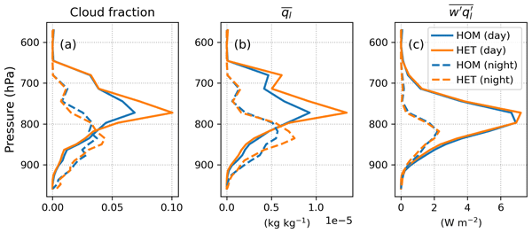
The land surface in one grid cell may be diverse in character. This study uses an explicit way to account for that subgrid diversity in a state-of-the-art Earth system model (ESM) and explores its implications for the overlying atmosphere. We find that the shallow clouds are increased significantly with the land surface diversity. Our work highlights the importance of accurately representing the land surface and its interaction with the atmosphere in next-generation ESMs.
Nathaniel W. Chaney, Laura Torres-Rojas, Noemi Vergopolan, and Colby K. Fisher
Geosci. Model Dev., 14, 6813–6832, https://doi.org/10.5194/gmd-14-6813-2021, https://doi.org/10.5194/gmd-14-6813-2021, 2021
Short summary
Short summary
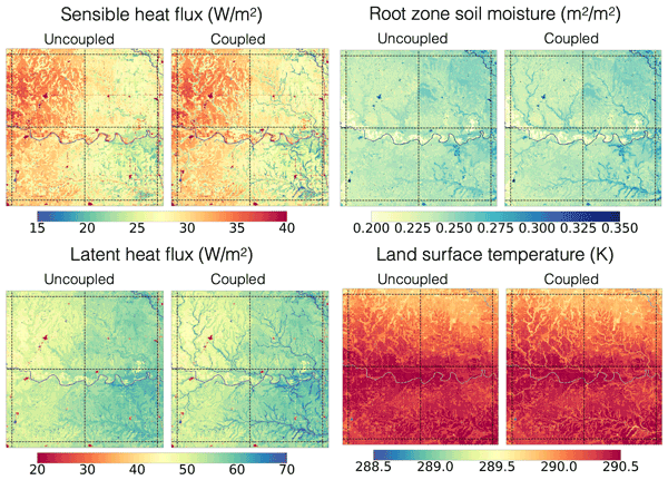
Although there have been significant advances in river routing and sub-grid heterogeneity (i.e., tiling) schemes in Earth system models over the past decades, there has yet to be a concerted effort to couple these two concepts. This paper aims to bridge this gap through the development of a two-way coupling between tiling schemes and river networks in the HydroBlocks land surface model. The scheme is implemented and tested over a 1 arc degree domain in Oklahoma, United States.
Cited articles
Afonin, N., Kozlovskaya, E., Moisio, K., Kokko, E.-R., and Okkonen, J.: Frost quakes in wetlands in northern Finland during extreme winter weather conditions and related hazard to urban infrastructure, The Cryosphere, 18, 2223–2238, https://doi.org/10.5194/tc-18-2223-2024, 2024. a
Autio, A., Ala-Aho, P., Rossi, P. M., Ronkanen, A.-K., Aurela, M., Lohila, A., Korpelainen, P., Kumpula, T., Klöve, B., and Marttila, H.: Groundwater exfiltration pattern determination in the sub-arctic catchment using thermal imaging, stable water isotopes and fully-integrated groundwater-surface water modelling, J. Hydrol., 626, 130342, https://doi.org/10.1016/j.jhydrol.2023.130342, 2023. a
Battaglia, S. M. and Changnon, D.: Frost quake events and changing wintertime air mass frequencies in Southeastern Canada, Working paper, Northern Illinois University, p. 12, https://doi.org/10.13140/RG.2.2.22351.48803, 2016. a, b
Chaney, N. W., Metcalfe, P., and Wood, E. F.: HydroBlocks: a field-scale resolving land surface model for application over continental extents, Hydrolog. Process., 30, 3543–3559, https://doi.org/10.1002/hyp.10891, 2016. a, b, c, d
FAO: Harmonized World Soil Database v2.0, https://www.fao.org/soils-portal/data-hub/soil-maps-and-databases/en/ (last access: 1 May 2023), 2023. a
Fisher, R. A. and Koven, C. D.: Perspectives on the Future of Land Surface Models and the Challenges of Representing Complex Terrestrial Systems, J. Adv. Model. Earth Sy., 12, e2018MS001453, https://doi.org/10.1029/2018MS001453, 2020. a, b, c
FMI: Hydrological monitoring, Snow statistics, Finnish Meteorological Institute, https://en.ilmatieteenlaitos.fi/snow-statistics (last access: June 2023), 2023. a
FMI: Yearly statistics, Finnish Meteorological Institute, https://www.ilmatieteenlaitos.fi/vuositilastot (last access: September 2024), 2024a. a
FMI: Meteorological data: air temperature and precipitation in Tähtelä, Sodankylä, Finnish Meteorological Institute, https://www.ilmatieteenlaitos.fi/havaintojen-lataus (last access: September 2024), 2024b. a
Guyumus, D., Torres-Rojas, L., Bacelar, L., Xu, C., and Chaney, N.: HydroBlocks-MSSUBv0.1: a multiscale approach for simulating lateral subsurface flow dynamics in Land Surface Models, Geosci. Model Dev., 19, 477–504, https://doi.org/10.5194/gmd-19-477-2026, 2026. a
Haldorsen, S.: The enrichment of quartz in tills, A. A. Balkema Publishers, 141–150, https://www.researchgate.net/publication/291755322_The_enrichment_of_quartz_in_tills 1 February 2026, 1983. a
He, C., Barlage, M., Liu, C., Newman, A., Tang, W., Ikeda, K., and Rasmussen, R.: Can Convection‐Permitting Modeling Provide Decent Precipitation for Offline High‐Resolution Snowpack Simulations Over Mountains?, J. Geophys. Res.-Atmos., 124, 12631–12654, https://doi.org/10.1029/2019JD030823, 2019. a
IPCC: Sections, in: Climate Change 2023: Synthesis Report. Contribution of Working Groups I, II and III to the Sixth Assessment Report of the Intergovernmental Panel on Climate Change, edited by: Core Writing Team, Lee, H., and Romero, J., IPCC, Geneva, Switzerland, 35–115, https://doi.org/10.59327/IPCC/AR6-9789291691647, 2023. a
Jakkila, J., Vento, T., Rousi, T., and Vehviläinen, B.: SMOS soil moisture data validation in the Aurajoki watershed, Finland, Hydrol. Res., 45, 684–702, https://doi.org/10.2166/nh.2013.234, 2014. a
Ji, P., Yuan, X., and Jiao, Y.: Synergistic Effects of High-Resolution Factors for Improving Soil Moisture Simulations Over China, Water Resour. Res., 59, e2023WR035513, https://doi.org/10.1029/2023WR035513, 2023. a
Kishne, A., Yimam, Y., Morgan, C., and Dornblaser, B.: Evaluation and improvement of the default soil hydraulic parameters for the Noah Land Surface Model, Geoderma, 285, https://doi.org/10.1016/j.geoderma.2016.09.022, 2017. a, b
Kokko, E.-R. and Chaney, N.: Supporting Dataset Modelling of temporal and spatial trends in soil conditions in Finland using HydroBlocks model, Zenodo [data set], https://doi.org/10.5281/zenodo.19405153, 2026. a
Kolhinen, V., Huttunen, M., Jakkila, J., Havu, P., Menberu, M., Kumpumäki, M., Fazel, N., Koistinen, A., Vehviläinen, B., and Veijalainen, N.: The development and validation of a national-scale process-based hydrological model for Finland, J. Hydrol., 665, 134650, https://doi.org/10.1016/j.jhydrol.2025.134650, 2026. a
Koren, V., Schaake, J. C., Mitchell, K. E., Duan, Q., Chen, F., and Baker, J. M.: A parameterization of snowpack and frozen ground intended for NCEP weather and climate models, J. Geophys. Res., 104, 19569–19585, https://doi.org/10.1029/1999JD900232, 1999. a, b
Kouki, K. and Colliander, A.: Characterizing precipitation and soil moisture drydowns in Finland using SMAP satellite data, Hydrol. Earth Syst. Sci., 29, 4791–4810, https://doi.org/10.5194/hess-29-4791-2025, 2025. a
Koven, C. D., Riley, W. J., Subin, Z. M., Tang, J. Y., Torn, M. S., Collins, W. D., Bonan, G. B., Lawrence, D. M., and Swenson, S. C.: The effect of vertically resolved soil biogeochemistry and alternate soil C and N models on C dynamics of CLM4, Biogeosciences, 10, 7109–7131, https://doi.org/10.5194/bg-10-7109-2013, 2013. a
Leung, A., Gough, W., and Yehong, S.: Identifying frost quakes in central Canada and neighbouring regions in the United States with social media, edited by: Leitner, M. and Jokar Arsanjani, J., Citizen Empowered Mapping, Geotechnologies and the Environment, vol. 18, Springer, Cham, https://doi.org/10.1007/978-3-319-51629-5_9, 2017. a
Li, L., Bisht, G., Hao, D., and Leung, L. R.: Global 1 km land surface parameters for kilometer-scale Earth system modeling, Earth Syst. Sci. Data, 16, 2007–2032, https://doi.org/10.5194/essd-16-2007-2024, 2024. a
Liwata, P., Hänninen, P., Okkonen, J., and Sutinen, R.: Time-stability of soil water through boreal (60–68° N) gradient, J. Hydrol., 519 B, 1584–1593, https://doi.org/10.1016/j.jhydrol.2014.09.009, 2014. a, b, c, d
Maertens, M., De Lannoy, G. J. M., Apers, S., Kumar, S. V., and Mahanama, S. P. P.: Land surface modeling over the Dry Chaco: the impact of model structures, and soil, vegetation and land cover parameters, Hydrol. Earth Syst. Sci., 25, 4099–4125, https://doi.org/10.5194/hess-25-4099-2021, 2021. a
Menberu, M., Jakkila, J., Veijalainen, N., Böttcher, K., Fronzek, S., Kolhinen, V., Havu, P., Fazel, N., Kumpumäki, M., Koistinen, A., and Huttunen, M.: Introducing WSFS-P, Process-based Version of the Watershed Simulation and Forecasting System (WSFS) in Finland, EGU General Assembly 2024, Vienna, Austria, 14–19 April 2024, EGU24-15445, https://doi.org/10.5194/egusphere-egu24-15445, 2024. a
Middleton, M., Närhi, P., Kuosmanen, V., and Sutinen, R.: Quantification of glacial till chemical composition by reflectance spectroscopy, Appl. Geochem., 26, 2215–2225, https://doi.org/10.1016/j.apgeochem.2011.08.004, 2011. a
MML: National Land Survey of Finland, Topographic Vector Database 1 : 100 000, https://asiointi.maanmittauslaitos.fi/karttapaikka/ (last access: June 2024), 2024. a
Muñoz-Sabater, J.: ERA5-Land hourly data from 1950 to present, Copernicus Climate Change Service (C3S) Climate Data Store (CDS) [data set], https://doi.org/10.24381/cds.e2161bac, 2019. a, b, c
Niu, G.-Y., Yang, Z.-L., Dickinson, R. E., and Gulden, L. E.: A simple TOPMODEL-based runoff parameterization (SIMTOP) for use in global climate models, J. Geophys. Res., 110, D21106, https://doi.org/10.1029/2005JD006111, 2005. a
Niu, G.-Y., Yang, Z.-L., Dickinson, R. E., Gulden, L. E., and Su, H.: Development of a simple groundwater model for use in climate models and evaluation with Gravity Recovery and Climate Experiment data, J. Geophys. Res., 112, D07103, https://doi.org/10.1029/2006JD007522, 2007. a
Niu, G.-Y., Yang, Z.-L., Mitchell, K. E., Chen, F., Ek, M. B., Barlage, M., Kumar, A., Manning, K., Niyogi, D., Rosero, E., Tewari, M., and Xia, Y.: The community Noah land surface model with multiparameterization options (Noah‐MP): 1. Model description and evaluation with local‐scale measurements, J. Geophys. Res., 116, D12109, https://doi.org/10.1029/2010JD015139, 2011. a, b, c, d, e, f
Okkonen, J., Neupauer, R. M., Kozlovskaya, E., Afonin, N., Moisio, K., Taewook, K., and Muurinen, E.: Frost quakes: Crack formation by thermal stress, J. Geophys. Res.-Earth, 125, https://doi.org/10.1029/2020JF005616, 2020. a, b, c, d
Oleson, K., Lawrence, D., and Bonan, G.: Technical description of version 4.5 of the Community Land Model (CLM). Ncar Tech. Note NCAR/TN-503+STR, National Center for Atmospheric Research, Boulder, https://www.researchgate.net/publication/261062374_Technical_description_of_version_45_of_the_Community_Land_Model_CLM (last access: 1 February 2026), 2013. a
Piniewski, M., Marcinkowski, P., Koskiaho, J., and Tattari, S.: The effect of sampling frequency and strategy on water quality modelling driven by high-frequency monitoring data in a boreal catchment, J. Hydrol., 579, 124186, https://doi.org/10.1016/j.jhydrol.2019.124186, 2019. a
Poggio, L., de Sousa, L. M., Batjes, N. H., Heuvelink, G. B. M., Kempen, B., Ribeiro, E., and Rossiter, D.: SoilGrids 2.0: producing soil information for the globe with quantified spatial uncertainty, SOIL, 7, 217–240, https://doi.org/10.5194/soil-7-217-2021, 2021. a, b, c, d
Rodell, M., Houser, P., Jambor, U., Gottschalck, J., Mitchell, K., Meng, C., Arsenault, K., Cosgrove, B., Radakovich, J., Bosilovich, M., Entin, J., Walker, J., Lohmann, D., and Toll, D.: The Global Land Data Assimilation System, B. Am. Meteorol. Soc., https://journals.ametsoc.org/view/journals/bams/85/3/bams-85-3-381.xml (last access: 1 February 2026), 2004. a
Ronkainen, N.: Suomen maalajien ominaisuuksia, Suomen Ympäristö (2), Suomen Ympäristökeskus, p. 62, https://helda.helsinki.fi/items/7094e61d-14de-448c-aed6-9601ffa16bc0 (last access: 1 August 2025), 2012. a
Saxton, K. and Rawls, W.: Soil Water Characteristic Estimates by Texture and Organic Matter for Hydrologic Solutions., Soil Sci. Soc. Am. J., 70, 1569–1578, https://doi.org/10.2136/sssaj2005.0117, 2006. a, b
Singh, R. S., Reager, J. T., Miller, N. L., and Famiglietti, J. S.: Toward hyper-resolution land-surface modeling: The effects of fine-scale topography and soil texture on CLM4.0 simulations over the Southwestern U.S., Water Resour. Res., 51, 2648–2667, https://doi.org/10.1002/2014WR015686, 2015. a
SYKE: Hydrological monitoring, Finnish Environmental Institute, Finnish Environment Institute, https://ckan.ymparisto.fi/dataset/%7B54BE2675-97A3-4258-A625-83E198ED0FFA%7D (last access: June 2022), 2022. a
Tähtikarhu, M. and Okkonen, J.: Analyzing Groundwater Recharge and Vadose Zone Dynamics by Combining Soil Moisture and Groundwater Level Data with a Numerical Model in Subarctic Conditions, J. Hydrol. Eng., 28, 05023001, https://doi.org/10.1061/JHYEFF.HEENG-5842, 2023. a, b, c
Thum, T., Räisänen, P., Sevanto, S., Tuomi, M., Reick, C., Vesala, T., Raddatz, T., Aalto, T., Järvinen, H., Altimir, N., Pilegaard, K., Zoltan, N., Rambal, S., and Liski, J.: Soil carbon model alternatives for ECHAM5/JSBACH climate model: evaluation and impacts on global carbon cycle estimates, J. Geophys. Res.-Biogeo., 116, G02028, https://doi.org/10.1029/2010JG001612, 2011. a
Timoshenko, S. and Goodier, J. N.: Theory of elasticity, Mcgraw-Hill Book Company, Inc., New York, p. 506, https://docs.google.com/file/d/0Bw8MfqmgWLS4NTlFNF9VZzBZdWs/view?resourcekey=0-mYqE4Eisqee-sI8xcqFa_A (last access: 1 February 2026), 1951. a
Vehviläinen, B. and Huttunen, M.: Hydrological forecasting and real time monitoring in Finland: The watershed simulation and forecasting system (WSFS), Finnish Environment Institute, Helsinki, Finland, http://hdl.handle.net/10138/170125 (last access: 1 February 2026), 2001. a
Vergopolan, N., Chaney, N. W., Beck, H. E., Pan, M., Sheffield, J., Chan, S., and Wood, E. F.: Combining hyper-resolution land surface modeling with SMAP brightness temperatures to obtain 30-m soil moisture estimates, Remote Sens. Environ., 242, 111740, https://www.sciencedirect.com/science/article/pii/S0034425720301103 (last access: 1 February 2026), 2020. a
Vergopolan, N., Chaney, N., Pan, M., Sheffield, J., Beck, H., Ferguson, C., Torres-Rojas, L., Sadri, S., and Wood, E.: SMAP-HydroBlocks, a 30-m satellite-based soil moisture dataset for the conterminous US, Sci. Data, 8, 264, https://doi.org/10.1038/s41597-021-01050-2, 2021. a
Yamazaki, D., Ikeshima, D., Tawatari, R., Yamaguchi, T., O'Loughlin, F., Neal, J., Sampson, C., S., K., and Bates, P. D.: A high accuracy map of global terrain elevations, Geophys. Res. Lett., 44, 5844–5853, https://doi.org/10.1002/2017GL072874, 2017. a, b, c
Ympäristöministeriö: Suomen maaperän seuranta, tila ja käytön ohjauskeinot, Ministery of the Environment, Ympäristöministeriön julkaisuja 2023:33, https://urn.fi/URN:ISBN:978-952-361-578-6 (last access: 1 February 2026), 2023. a
Zhang, Z., Laux, P., Baade, J., Arnault, J., Wei, J., Wang, X., Liu, Y., Schmullius, C., and Kunstmann, H.: Impact of alternative soil data sources on the uncertainties in simulated land-atmosphere interactions, Agr. Forest Meteorol., 339, 109565, https://doi.org/10.1016/j.agrformet.2023.109565, 2023. a, b
Short summary
HydroBlocks model, was configured over Finland. Time series of snow water equivalent, soil temperature, soil water content and soil ice content were created. Observational data was used to evaluate the model performance. HydroBlocks can generally predict soil conditions in Finland with some uncertainty. The model performance is improved with using local soil data and local soil hydraulic parameters. In the future, the modelling outputs show potential to be used in environmental applications.
HydroBlocks model, was configured over Finland. Time series of snow water equivalent, soil...


