
Articles | Volume 30, issue 14
https://doi.org/10.5194/hess-30-4629-2026
© Author(s) 2026. This work is distributed under
the Creative Commons Attribution 4.0 License.
the Creative Commons Attribution 4.0 License.
https://doi.org/10.5194/hess-30-4629-2026
© Author(s) 2026. This work is distributed under
the Creative Commons Attribution 4.0 License.
the Creative Commons Attribution 4.0 License.
Research article
| 
22 Jul 2026
Research article |
| 22 Jul 2026
| 22 Jul 2026
Benchmarking reservoir operation schemes for large-scale hydrological models
Jesús Casado-Rodríguez
CORRESPONDING AUTHOR

European Commission – Joint Research Centre, Ispra, Italy
now at: Kajo s.r.o., Banská Bystrica, Slovakia
Juliana Disperati
Fincons Group, Vimercate, Italy
Stefania Grimaldi
European Commission – Joint Research Centre, Ispra, Italy
European Commission – Joint Research Centre, Ispra, Italy
Related authors
Valentina Premier, Francesca Moschini, Jesús Casado-Rodríguez, Davide Bavera, Carlo Marin, and Alberto Pistocchi
Hydrol. Earth Syst. Sci., 30, 1189–1220, https://doi.org/10.5194/hess-30-1189-2026, https://doi.org/10.5194/hess-30-1189-2026, 2026
Short summary
Short summary
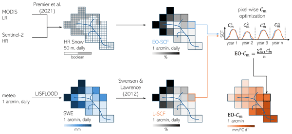
This study evaluates the snow module of LISFLOOD by replacing the discharge-calibrated snowmelt coefficient with pixel-wise values calibrated using EO (Earth Observation) snow cover fraction after standard streamflow calibration. Using a gap-filled high-resolution daily snow dataset, the approach improves snow cover representation across European basins while largely preserving discharge performance, without requiring full model recalibration.
Lorenzo Scarpellini, Andrea Ficchì, Claudia D'Angelo, Andrea Betterle, Peter Salamon, and Andrea Castelletti
EGUsphere, https://doi.org/10.5194/egusphere-2026-2807, https://doi.org/10.5194/egusphere-2026-2807, 2026
Short summary
Short summary
This study shows that flood protection assumptions strongly affect risk estimates, and that flood model simulations, satellite observations, and historical records often disagree. Simulations overestimate large floods, satellites miss small ones, and historical records favour populated areas. No single data source provides a complete picture, highlighting the need to combine multiple datasets for more reliable continental-scale flood risk assessments.
Peter Salamon, Tim Sperzel, Goncalo Ramos Gomes, Marco Radke-Fretz, Carina-Denise Lemke, Carlo Russo, Christoph Schweim, Ervin Zsoter, Alessandro Dosio, Mariapina Vomero, Markus Ziese, and Stefania Grimaldi
Earth Syst. Sci. Data Discuss., https://doi.org/10.5194/essd-2025-723, https://doi.org/10.5194/essd-2025-723, 2026
Preprint under review for ESSD
Short summary
Short summary
We introduce the European Meteorological Observations -1 (EMO-1) dataset developed to support the European Flood Awareness System. EMO-1 provides maps with interpolated meteorological observations across Europe at daily and 6-hourly time steps and with a pixel size of ~1.5 km for the period 1990–2024. The dataset uses observations from thousands of meteorological stations from 47 different data providers for interpolation. It is publicly available at the Joint Research Centre Data Catalogue.
Valentina Premier, Francesca Moschini, Jesús Casado-Rodríguez, Davide Bavera, Carlo Marin, and Alberto Pistocchi
Hydrol. Earth Syst. Sci., 30, 1189–1220, https://doi.org/10.5194/hess-30-1189-2026, https://doi.org/10.5194/hess-30-1189-2026, 2026
Short summary
Short summary
This study evaluates the snow module of LISFLOOD by replacing the discharge-calibrated snowmelt coefficient with pixel-wise values calibrated using EO (Earth Observation) snow cover fraction after standard streamflow calibration. Using a gap-filled high-resolution daily snow dataset, the approach improves snow cover representation across European basins while largely preserving discharge performance, without requiring full model recalibration.
Andrea Ficchì, Davide Bavera, Stefania Grimaldi, Francesca Moschini, Alberto Pistocchi, Carlo Russo, Peter Salamon, and Andrea Toreti
EGUsphere, https://doi.org/10.5194/egusphere-2026-43, https://doi.org/10.5194/egusphere-2026-43, 2026
Short summary
Short summary
This study introduces a new metric for hydrological model calibration combining traditional model efficiency measures with a new component to better assess similarity between observed and simulated river flows. Tests on two hydrological models and large catchment samples show improved low-flow simulations without degrading high-flow accuracy. The new metric can support more reliable modeling for droughts and floods and is already being adopted in operational monitoring and forecasting systems.
Serigne Bassirou Diop, Job Ekolu, Yves Tramblay, Bastien Dieppois, Stefania Grimaldi, Ansoumana Bodian, Juliette Blanchet, Ponnambalam Rameshwaran, Peter Salamon, and Benjamin Sultan
Nat. Hazards Earth Syst. Sci., 25, 3161–3184, https://doi.org/10.5194/nhess-25-3161-2025, https://doi.org/10.5194/nhess-25-3161-2025, 2025
Short summary
Short summary
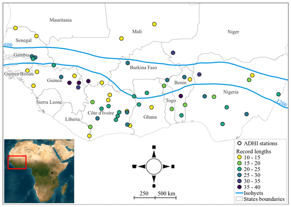
West Africa is very vulnerable to river floods. Current flood hazards are poorly understood due to limited data. This study is filling this knowledge gap using recent databases and two regional hydrological models to analyze changes in flood risk under two climate scenarios. Results show that most areas will see more frequent and severe floods, with some increasing by over 45 %. These findings stress the urgent need for climate-resilient strategies to protect communities and infrastructure.
Aloïs Tilloy, Dominik Paprotny, Stefania Grimaldi, Goncalo Gomes, Alessandra Bianchi, Stefan Lange, Hylke Beck, Cinzia Mazzetti, and Luc Feyen
Earth Syst. Sci. Data, 17, 293–316, https://doi.org/10.5194/essd-17-293-2025, https://doi.org/10.5194/essd-17-293-2025, 2025
Short summary
Short summary
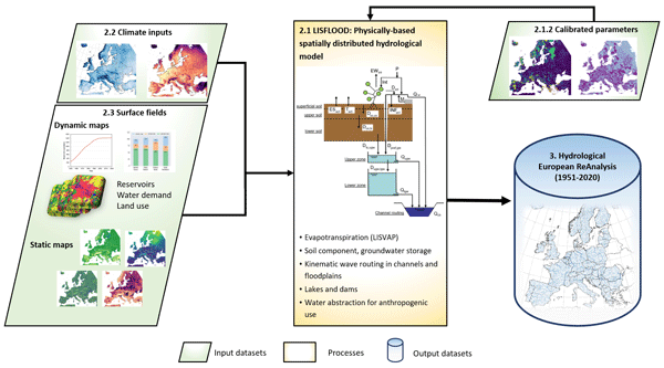
This article presents a reanalysis of Europe's river streamflow for the period 1951–2020. Streamflow is estimated through a state-of-the-art hydrological simulation framework benefitting from detailed information about the landscape, climate, and human activities. The resulting Hydrological European ReAnalysis (HERA) can be a valuable tool for studying hydrological dynamics, including the impacts of climate change and human activities on European water resources and flood and drought risks.
Andrea Betterle and Peter Salamon
Nat. Hazards Earth Syst. Sci., 24, 2817–2836, https://doi.org/10.5194/nhess-24-2817-2024, https://doi.org/10.5194/nhess-24-2817-2024, 2024
Short summary
Short summary
The study proposes a new framework, named FLEXTH, to estimate flood water depth and improve satellite-based flood monitoring using topographical data. FLEXTH is readily available as a computer code, offering a practical and scalable solution for estimating flood depth quickly and systematically over large areas. The methodology can reduce the impacts of floods and enhance emergency response efforts, particularly where resources are limited.
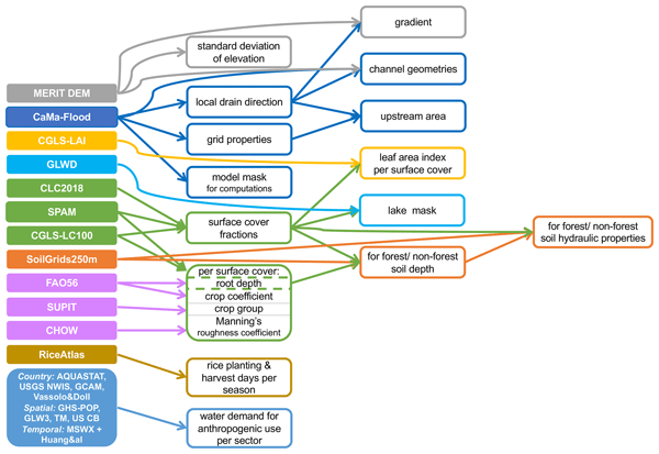
Margarita Choulga, Francesca Moschini, Cinzia Mazzetti, Stefania Grimaldi, Juliana Disperati, Hylke Beck, Peter Salamon, and Christel Prudhomme
Hydrol. Earth Syst. Sci., 28, 2991–3036, https://doi.org/10.5194/hess-28-2991-2024, https://doi.org/10.5194/hess-28-2991-2024, 2024
Short summary
Short summary
CEMS_SurfaceFields_2022 dataset is a new set of high-resolution maps for land type (e.g. lake, forest), soil properties and population water needs at approximately 2 and 6 km at the Equator, covering Europe and the globe (excluding Antarctica). We describe what and how new high-resolution information can be used to create the dataset. The paper suggests that the dataset can be used as input for river, weather or other models, as well as for statistical descriptions of the region of interest.
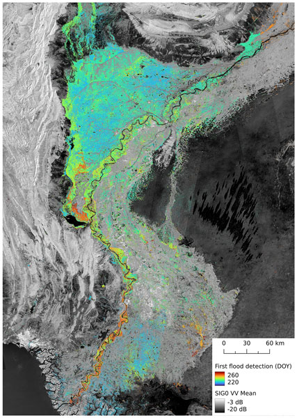
Florian Roth, Bernhard Bauer-Marschallinger, Mark Edwin Tupas, Christoph Reimer, Peter Salamon, and Wolfgang Wagner
Nat. Hazards Earth Syst. Sci., 23, 3305–3317, https://doi.org/10.5194/nhess-23-3305-2023, https://doi.org/10.5194/nhess-23-3305-2023, 2023
Short summary
Short summary
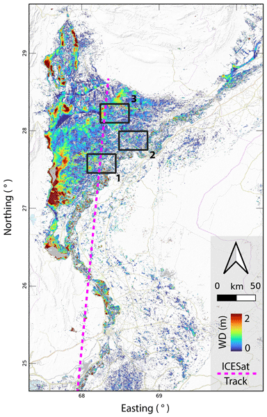
In August and September 2022, millions of people were impacted by a severe flood event in Pakistan. Since many roads and other infrastructure were destroyed, satellite data were the only way of providing large-scale information on the flood's impact. Based on the flood mapping algorithm developed at Technische Universität Wien (TU Wien), we mapped an area of 30 492 km2 that was flooded at least once during the study's time period. This affected area matches about the total area of Belgium.
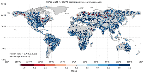
Shaun Harrigan, Ervin Zsoter, Hannah Cloke, Peter Salamon, and Christel Prudhomme
Hydrol. Earth Syst. Sci., 27, 1–19, https://doi.org/10.5194/hess-27-1-2023, https://doi.org/10.5194/hess-27-1-2023, 2023
Short summary
Short summary
Real-time river discharge forecasts and reforecasts from the Global Flood Awareness System (GloFAS) have been made publicly available, together with an evaluation of forecast skill at the global scale. Results show that GloFAS is skillful in over 93 % of catchments in the short (1–3 d) and medium range (5–15 d) and skillful in over 80 % of catchments in the extended lead time (16–30 d). Skill is summarised in a new layer on the GloFAS Web Map Viewer to aid decision-making.
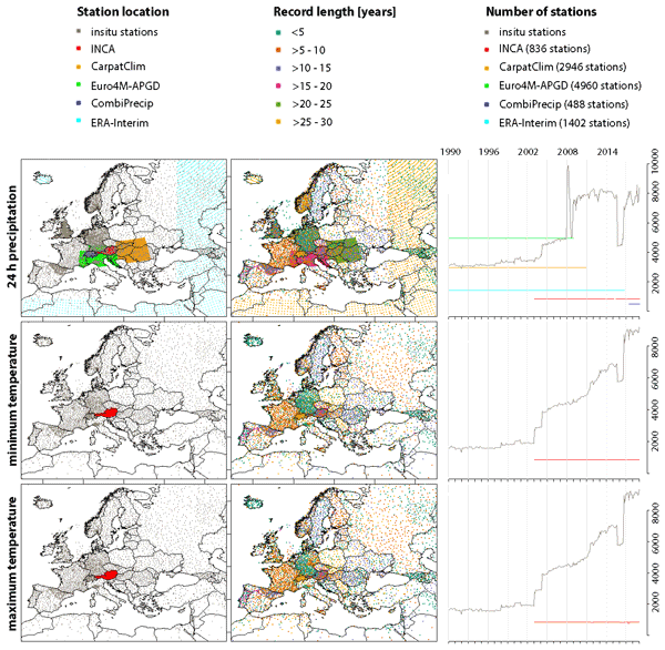
Vera Thiemig, Goncalo N. Gomes, Jon O. Skøien, Markus Ziese, Armin Rauthe-Schöch, Elke Rustemeier, Kira Rehfeldt, Jakub P. Walawender, Christine Kolbe, Damien Pichon, Christoph Schweim, and Peter Salamon
Earth Syst. Sci. Data, 14, 3249–3272, https://doi.org/10.5194/essd-14-3249-2022, https://doi.org/10.5194/essd-14-3249-2022, 2022
Short summary
Short summary
EMO-5 is a free and open European high-resolution (5 km), sub-daily, multi-variable (precipitation, temperatures, wind speed, solar radiation, vapour pressure), multi-decadal meteorological dataset based on quality-controlled observations coming from almost 30 000 stations across Europe, and is produced in near real-time. EMO-5 (v1) covers the time period from 1990 to 2019. In this paper, we have provided insight into the source data, the applied methods, and the quality assessment of EMO-5.
Francesco Dottori, Lorenzo Alfieri, Alessandra Bianchi, Jon Skoien, and Peter Salamon
Earth Syst. Sci. Data, 14, 1549–1569, https://doi.org/10.5194/essd-14-1549-2022, https://doi.org/10.5194/essd-14-1549-2022, 2022
Short summary
Short summary
We present a set of hazard maps for river flooding for Europe and the Mediterranean basin. The maps depict inundation extent and depth for flood probabilities for up to 1-in-500-year flood hazards and are based on hydrological and hydrodynamic models driven by observed climatology. The maps can identify two-thirds of the flood extent reported by official flood maps, with increasing skill for higher-magnitude floods. The maps are used for evaluating present and future impacts of river floods.
Cited articles
Abeshu, G. W., Tian, F., Wild, T., Zhao, M., Turner, S., Chowdhury, A. F. M. K., Vernon, C. R., Hu, H., Zhuang, Y., Hejazi, M., and Li, H.-Y.: Enhancing the representation of water management in global hydrological models, Geosci. Model Dev., 16, 5449–5472, https://doi.org/10.5194/gmd-16-5449-2023, 2023. a
Baratgin, L., Polcher, J., Dumas, P., and Quirion, P.: Modeling hydropower operations at the scale of a power grid: a demand-based approach, Hydrol. Earth Syst. Sci., 28, 5479–5509, https://doi.org/10.5194/hess-28-5479-2024, 2024. a
Beven, K. and Freer, J.: Equifinality, data assimilation, and uncertainty estimation in mechanistic modelling of complex environmental systems using the GLUE methodology, J. Hydrol., 249, 11–29, https://doi.org/10.1016/S0022-1694(01)00421-8, 2001. a
Biemans, H., Haddeland, I., Kabat, P., Ludwig, F., Hutjes, R. W., Heinke, J., Bloh, W. V., and Gerten, D.: Impact of reservoirs on river discharge and irrigation water supply during the 20th century, Water Resour. Res., 47, https://doi.org/10.1029/2009WR008929, 2011. a
Burek, P., van der Knijff, J., and de Roo, A.: LISFLOOD. Distributed Water Balance and Flood Simulation Model, Tech. rep., European Commission – Joint Research Centre, Luxembourg, ISBN 879-92-79-33190-9, https://doi.org/10.2788/24719, 2013. a, b
Busker, T., de Roo, A., Gelati, E., Schwatke, C., Adamovic, M., Bisselink, B., Pekel, J.-F., and Cottam, A.: A global lake and reservoir volume analysis using a surface water dataset and satellite altimetry, Hydrol. Earth Syst. Sci., 23, 669–690, https://doi.org/10.5194/hess-23-669-2019, 2019. a, b
Casado Rodríguez, J.: casadoj/reservoirs-LSHM: Version used in the paper (Version v1.0.0), Zenodo [code], https://doi.org/10.5281/zenodo.21370914, 2026. a
Casado Rodríguez, J., Disperati, J., and Salamon, P.: ResOpsUS+CARS: Reservoir Operations US and CAtchment and Reservoir Static attributes (Version 1.0), Zenodo [data set], https://doi.org/10.5281/zenodo.15978041, 2025. a, b
Choulga, M., Moschini, F., Mazzetti, C., Grimaldi, S., Disperati, J., Beck, H., Salamon, P., and Prudhomme, C.: Technical note: Surface fields for global environmental modelling, Hydrol. Earth Syst. Sci., 28, 2991–3036, https://doi.org/10.5194/hess-28-2991-2024, 2024. a
Coerver, H. M., Rutten, M. M., and van de Giesen, N. C.: Deduction of reservoir operating rules for application in global hydrological models, Hydrol. Earth Syst. Sci., 22, 831–851, https://doi.org/10.5194/hess-22-831-2018, 2018. a, b
Duan, Q., Gupta, V. K., and Sorooshian, S.: Shuffled complex evolution approach for effective and efficient global minimization, J. Optimiz. Theory App., 76, 501–521, 1993. a
Duan, Q., Sorooshian, S., and Gupta, V. K.: Optimal use of the SCE-UA global optimization method for calibrating watershed models, J. Hydrol., 158, 265–284, 1994. a
Haddeland, I., Skaugen, T., and Lettenmaier, D. P.: Anthropogenic impacts on continental surface water fluxes, Geophys. Res. Lett., 33, https://doi.org/10.1029/2006GL026047, 2006. a
Hanasaki, N., Kanae, S., and Oki, T.: A reservoir operation scheme for global river routing models, J. Hydrol., 327, 22–41, https://doi.org/10.1016/j.jhydrol.2005.11.011, 2006. a, b
Hao, Z., Chen, F., Jia, X., Cai, X., Yang, C., Du, Y., and Ling, F.: GRDL: A new global reservoir area-storage-depth data set derived through deep learning-based bathymetry reconstruction, Water Resour. Res., https://doi.org/10.1029/2023WR035781, 2024. a, b, c
Hersbach, H., Bell, B., Berrisford, P., Hirahara, S., Horányi, A., Muñoz-Sabater, J., Nicolas, J., Peubey, C., Radu, R., Schepers, D., Simmons, A., Soci, C., Abdalla, S., Abellan, X., Balsamo, G., Bechtold, P., Biavati, G., Bidlot, J., Bonavita, M., De Chiara, G., Dahlgren, P., Dee, D., Diamantakis, M., Dragani, R., Flemming, J., Forbes, R., Fuentes, M., Geer, A., Haimberger, L., Healy, S., Hogan, R. J., Hólm, E., Janisková, M., Keeley, S., Laloyaux, P., Lopez, P., Lupu, C., Radnoti, G., de Rosnay, P., Rozum, I., Vamborg, F., Villaume, S., and Thépaut, J. N.: The ERA5 global reanalysis, Q. J. Roy. Meteorol. Soc., 146, 1999–2049, https://doi.org/10.1002/qj.3803, 2020. a, b
Hou, J., Van Dijk, A. I. J. M., Renzullo, L. J., and Larraondo, P. R.: GloLakes: water storage dynamics for 27 000 lakes globally from 1984 to present derived from satellite altimetry and optical imaging, Earth Syst. Sci. Data, 16, 201–218, https://doi.org/10.5194/essd-16-201-2024, 2024. a, b, c
Houska, T., Kraft, P., Chamorro-Chavez, A., and Breuer, L.: SPOTting model parameters using a ready-made python package, PLoS ONE, 10, 1–22, https://doi.org/10.1371/journal.pone.0145180, 2015. a
JRC: European Flood Awareness System, https://european-flood.emergency.copernicus.eu/en (last access: 5 January 2026), 2026a. a
JRC: Global Flood Awareness System, https://global-flood.emergency.copernicus.eu/ (last access: 5 January 2026), 2026b. a
JRC: Open Source Lisflood, https://ec-jrc.github.io/lisflood/ (last access: 5 January 2026), 2026c. a
Khandelwal, A., Karpatne, A., Ravirathinam, P., Ghosh, R., Wei, Z., Dugan, H. A., Hanson, P. C., and Kumar, V.: ReaLSAT, a global dataset of reservoir and lake surface area variations, Scientific Data, 9, https://doi.org/10.1038/s41597-022-01449-5, 2022. a, b
Khazaei, B., Read, L. K., Casali, M., Sampson, K. M., and Yates, D. N.: GLOBathy, the global lakes bathymetry dataset, Scientific Data, 9, https://doi.org/10.1038/s41597-022-01132-9, 2022. a
Kling, H., Fuchs, M., and Paulin, M.: Runoff conditions in the upper Danube basin under an ensemble of climate change scenarios, J. Hydrol., 424–425, 264–277, https://doi.org/10.1016/j.jhydrol.2012.01.011, 2012. a
Kratzert, F., Nearing, G., Addor, N., Erickson, T., Gauch, M., Gilon, O., Gudmundsson, L., Hassidim, A., Klotz, D., Nevo, S., Shalev, G., and Matias, Y.: Caravan – A global community dataset for large-sample hydrology, Scientific Data, 10, https://doi.org/10.1038/s41597-023-01975-w, 2023. a, b
Kumar, R., Samaniego, L., and Attinger, S.: Implications of distributed hydrologic model parameterization on water fluxes at multiple scales and locations, Water Resour. Res., 49, 360–379, https://doi.org/10.1029/2012WR012195, 2013. a
Lehner, B., Liermann, C. R., Revenga, C., Vörömsmarty, C., Fekete, B., Crouzet, P., Döll, P., Endejan, M., Frenken, K., Magome, J., Nilsson, C., Robertson, J. C., Rödel, R., Sindorf, N., and Wisser, D.: High-resolution mapping of the world's reservoirs and dams for sustainable river-flow management, Front. Ecol. Environ., 9, 494–502, https://doi.org/10.1890/100125, 2011. a, b
Lehner, B., Beames, P., Mulligan, M., Zarfl, C., De Felice, L., van Soesbergen, A., Thieme, M., Garcia de Leaniz, C., Anand, M., Belletti, B., Brauman, K. A., Januchowski-Hartley, S. R., Lyon, K., Mandle, L., Mazany-Wright, N., Messager, M. L., Pavelsky, T., Pekel, J.-F., Wang, J., Wen, Q., Wishart, M., Xing, T., Yang, X., and Higgins, J.: The Global Dam Watch database of river barrier and reservoir information for large-scale applications, Scientific Data, 11, 1069, https://doi.org/10.1038/s41597-024-03752-9, 2024. a, b, c, d, e
Liebe, J., van de Giesen, N., and Andreini, M.: Estimation of small reservoir storage capacities in a semi-arid environment, Phys. Chem. Earth, 30, 448–454, https://doi.org/10.1016/j.pce.2005.06.011, 2005. a, b
Liu, Y., Xie, X., Wang, Y., Tursun, A., Peng, D., Wu, X., and Xue, B.: Increased surface water evaporation loss induced by reservoir development on the Loess Plateau, Hydrol. Earth Syst. Sci., 30, 67–89, https://doi.org/10.5194/hess-30-67-2026, 2026. a
Mekonnen, M. M. and Hoekstra, A. Y.: The blue water footprint of electricity from hydropower, Hydrol. Earth Syst. Sci., 16, 179–187, https://doi.org/10.5194/hess-16-179-2012, 2012. a
Moreno-Rodenas, A., Mantilla-Jones, J. D., and Valero, D.: Age, climate and economic disparities drive the current state of global dam safety, Nature Water, https://doi.org/10.1038/s44221-025-00402-1, 2025. a, b, c, d
Nearing, G., Cohen, D., Dube, V., Gauch, M., Gilon, O., Harrigan, S., Hassidim, A., Klotz, D., Kratzert, F., Metzger, A., Nevo, S., Pappenberger, F., Prudhomme, C., Shalev, G., Shenzis, S., Tekalign, T. Y., Weitzner, D., and Matias, Y.: Global prediction of extreme floods in ungauged watersheds, Nature, 627, 559–563, https://doi.org/10.1038/s41586-024-07145-1, 2024. a
Pekel, J. F., Cottam, A., Gorelick, N., and Belward, A. S.: High-resolution mapping of global surface water and its long-term changes, Nature, 540, 418–422, https://doi.org/10.1038/nature20584, 2016. a
Roo, A. P. D., Wesseling, C. G., and Deursen, W. P. V.: Physically based river basin modelling within a GIS: The LISFLOOD model, Hydrol. Process., 14, 1981–1992, https://doi.org/10.1002/1099-1085(20000815/30)14:11/12<1981::aid-hyp49>3.0.co;2-f, 2000. a
Salamon, P. and the team of co-authors: Improving hydrological modelling and prediction at the European and Global scale, EGU General Assembly 2025, Vienna, Austria, 27 Apr–2 May 2025, EGU25-8642, https://doi.org/10.5194/egusphere-egu25-8642, 2025. a
Samaniego, L., Kumar, R., and Attinger, S.: Multiscale parameter regionalization of a grid-based hydrologic model at the mesoscale, Water Resour. Res., 46, 1–25, https://doi.org/10.1029/2008WR007327, 2010. a
Scherer, L. and Pfister, S.: Global water footprint assessment of hydropower, Renew. Energ., 99, 711–720, https://doi.org/10.1016/j.renene.2016.07.021, 2016. a, b
Schwatke, C., Dettmering, D., Bosch, W., and Seitz, F.: DAHITI – an innovative approach for estimating water level time series over inland waters using multi-mission satellite altimetry, Hydrol. Earth Syst. Sci., 19, 4345–4364, https://doi.org/10.5194/hess-19-4345-2015, 2015. a
Schwatke, C., Dettmering, D., and Seitz, F.: Volume variations of small inland water bodies from a combination of satellite altimetry and optical imagery, Remote Sensing, 12, https://doi.org/10.3390/rs12101606, 2020. a, b
Shen, H., Tolson, B. A., and Mai, J.: Time to Update the Split-Sample Approach in Hydrological Model Calibration, Water Resour. Res., 58, https://doi.org/10.1029/2021WR031523, 2022. a
Shin, S., Pokhrel, Y., and Miguez-Macho, G.: High-Resolution Modeling of Reservoir Release and Storage Dynamics at the Continental Scale, Water Resour. Res., 55, 787–810, https://doi.org/10.1029/2018WR023025, 2019. a, b, c, d
Steyaert, J. C. and Condon, L. E.: Synthesis of historical reservoir operations from 1980 to 2020 for the evaluation of reservoir representation in large-scale hydrologic models, Hydrol. Earth Syst. Sci., 28, 1071–1088, https://doi.org/10.5194/hess-28-1071-2024, 2024. a, b
Thober, S., Cuntz, M., Kelbling, M., Kumar, R., Mai, J., and Samaniego, L.: The multiscale routing model mRM v1.0: simple river routing at resolutions from 1 to 50 km, Geosci. Model Dev., 12, 2501–2521, https://doi.org/10.5194/gmd-12-2501-2019, 2019. a
US Army Corps of Engineers: National Inventory of Dams, https://nid.sec.usace.army.mil/#/ (last access: 13 June 2025), 2025. a
US Bureau of Reclamation: Projects & Facilities, https://www.usbr.gov/projects/facilities.php?type=Dam (last access: 13 June 2025), 2025. a
US Geological Survey: Water Data for the Nation, https://waterdata.usgs.gov/ (last access: 13 June 2025), 2025. a
van der Knijff, J. M., Younis, J., and de Roo, A. P.: LISFLOOD: A GIS-based distributed model for river basin scale water balance and flood simulation, Int. J. Geogr. Inf. Sci., 24, 189–212, https://doi.org/10.1080/13658810802549154, 2010. a
Yassin, F., Razavi, S., Elshamy, M., Davison, B., Sapriza-Azuri, G., and Wheater, H.: Representation and improved parameterization of reservoir operation in hydrological and land-surface models, Hydrol. Earth Syst. Sci., 23, 3735–3764, https://doi.org/10.5194/hess-23-3735-2019, 2019. a, b, c
Yigzaw, W., Li, H. Y., Demissie, Y., Hejazi, M. I., Leung, L. R., Voisin, N., and Payn, R.: A New Global Storage-Area-Depth Data Set for Modeling Reservoirs in Land Surface and Earth System Models, Water Resour. Res., 54, 10372–10386, https://doi.org/10.1029/2017WR022040, 2018. a
Zajac, Z., Revilla-Romero, B., Salamon, P., Burek, P., Hirpa, F., and Beck, H.: The impact of lake and reservoir parameterization on global streamflow simulation, J. Hydrol., 548, 552–568, https://doi.org/10.1016/j.jhydrol.2017.03.022, 2017. a, b, c
Zhao, G. and Gao, H.: Automatic Correction of Contaminated Images for Assessment of Reservoir Surface Area Dynamics, Geophys. Res. Lett., 6092–6099, https://doi.org/10.1038/nature20584, 2018. a
Short summary
Dams significantly change river flows, yet they are difficult to represent in global hydrological models. We tested four different modeling methods using data from 164 reservoirs to find the most effective approach. We found that tracking water storage is better than tracking outflow for predicting reservoir behavior. This discovery enables the use of satellite information for better water management. These improvements are being implemented in the European and Global Flood Awareness Systems.
Dams significantly change river flows, yet they are difficult to represent in global...


