Articles | Volume 30, issue 20
https://doi.org/10.5194/hess-30-6661-2026
© Author(s) 2026. This work is distributed under
the Creative Commons Attribution 4.0 License.
https://doi.org/10.5194/hess-30-6661-2026
© Author(s) 2026. This work is distributed under
the Creative Commons Attribution 4.0 License.
High-resolution mapping of pluvial flooding in ungauged agricultural catchments

Matthieu Herpoel
CORRESPONDING AUTHOR
TERRA Teaching and Research Centre, Gembloux Agro-Bio Tech, University of Liège, Gembloux, 5030, Belgium
Pierre Baert
TERRA Teaching and Research Centre, Gembloux Agro-Bio Tech, University of Liège, Gembloux, 5030, Belgium
Charles Bielders
Earth and Life Institute – Environmental sciences, Université catholique de Louvain, Croix du Sud 2, bte2, Louvain-la-Neuve, 1348, Belgium
Gilles Swerts
TERRA Teaching and Research Centre, Gembloux Agro-Bio Tech, University of Liège, Gembloux, 5030, Belgium
Aurore Degré
TERRA Teaching and Research Centre, Gembloux Agro-Bio Tech, University of Liège, Gembloux, 5030, Belgium
Related authors
No articles found.
Eric Lutete Landu, Guy Ilombe Mawe, Elise Dujardin, Fils Makanzu Imwangana, Charles Bielders, Olivier Dewitte, Jean Poesen, Caroline Michellier, Aurélia Hubert, and Matthias Vanmaercke
EGUsphere, https://doi.org/10.5194/egusphere-2026-1774, https://doi.org/10.5194/egusphere-2026-1774, 2026
Short summary
Short summary
Urban gullies are a major problem in Kinshasa, caused by poor planning, fragile soils, and heavy rainfall. They destroy homes, disrupt services, and reduce land value, increasing poverty. A study of 802 households near 183 gullies and 12 brokers shows severe damage and high costs, with property losses estimated at 979 million dollars. Many people underestimate risks, and local solutions are often ineffective, highlighting the urgent need for better planning, prevention and coordinated action.
Benjamin Guillaume, Adrien Michez, and Aurore Degré
Hydrol. Earth Syst. Sci., 29, 4661–4688, https://doi.org/10.5194/hess-29-4661-2025, https://doi.org/10.5194/hess-29-4661-2025, 2025
Short summary
Short summary
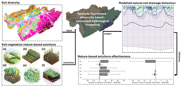
Nature-based solutions (NbSs) can mitigate floods and agricultural droughts by enhancing soil health and restoring hydrological cycles. This study highlights that leveraging soil diversity is key to optimizing NbS performance.
Tobias Karl David Weber, Lutz Weihermüller, Attila Nemes, Michel Bechtold, Aurore Degré, Efstathios Diamantopoulos, Simone Fatichi, Vilim Filipović, Surya Gupta, Tobias L. Hohenbrink, Daniel R. Hirmas, Conrad Jackisch, Quirijn de Jong van Lier, John Koestel, Peter Lehmann, Toby R. Marthews, Budiman Minasny, Holger Pagel, Martine van der Ploeg, Shahab Aldin Shojaeezadeh, Simon Fiil Svane, Brigitta Szabó, Harry Vereecken, Anne Verhoef, Michael Young, Yijian Zeng, Yonggen Zhang, and Sara Bonetti
Hydrol. Earth Syst. Sci., 28, 3391–3433, https://doi.org/10.5194/hess-28-3391-2024, https://doi.org/10.5194/hess-28-3391-2024, 2024
Short summary
Short summary
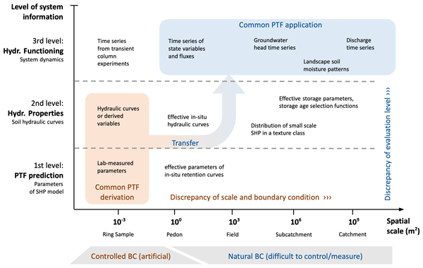
Pedotransfer functions (PTFs) are used to predict parameters of models describing the hydraulic properties of soils. The appropriateness of these predictions critically relies on the nature of the datasets for training the PTFs and the physical comprehensiveness of the models. This roadmap paper is addressed to PTF developers and users and critically reflects the utility and future of PTFs. To this end, we present a manifesto aiming at a paradigm shift in PTF research.
Benjamin Guillaume, Hanane Aroui Boukbida, Gerben Bakker, Andrzej Bieganowski, Yves Brostaux, Wim Cornelis, Wolfgang Durner, Christian Hartmann, Bo V. Iversen, Mathieu Javaux, Joachim Ingwersen, Krzysztof Lamorski, Axel Lamparter, András Makó, Ana María Mingot Soriano, Ingmar Messing, Attila Nemes, Alexandre Pomes-Bordedebat, Martine van der Ploeg, Tobias Karl David Weber, Lutz Weihermüller, Joost Wellens, and Aurore Degré
SOIL, 9, 365–379, https://doi.org/10.5194/soil-9-365-2023, https://doi.org/10.5194/soil-9-365-2023, 2023
Short summary
Short summary
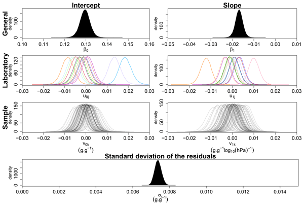
Measurements of soil water retention properties play an important role in a variety of societal issues that depend on soil water conditions. However, there is little concern about the consistency of these measurements between laboratories. We conducted an interlaboratory comparison to assess the reproducibility of the measurement of the soil water retention curve. Results highlight the need to harmonize and standardize procedures to improve the description of unsaturated processes in soils.
Jean-Claude Maki Mateso, Charles L. Bielders, Elise Monsieurs, Arthur Depicker, Benoît Smets, Théophile Tambala, Luc Bagalwa Mateso, and Olivier Dewitte
Nat. Hazards Earth Syst. Sci., 23, 643–666, https://doi.org/10.5194/nhess-23-643-2023, https://doi.org/10.5194/nhess-23-643-2023, 2023
Short summary
Short summary
This research highlights the importance of human activities on the occurrence of landslides and the need to consider this context when studying hillslope instability patterns in regions under anthropogenic pressure. Also, this study highlights the importance of considering the timing of landslides and hence the added value of using historical information for compiling an inventory.
Cited articles
Alexopoulos, M. J., Dimitriadis, P., Iliopoulou, T., Bezak, N., Kobold, M., and Koutsoyiannis, D.: Effects of digital elevation model resolution on rain-on-grid simulations: a case study in a Slovenian watershed, Hydrolog. Sci. J., 69, 1468–1485, https://doi.org/10.1080/02626667.2024.2378487, 2024.
Arcement, G. J. and Schneider, V. R.: Guide for selecting Manning's roughness coefficients for natural channels and flood plains, Water Supply Paper, U.S. G.P.O. ; For sale by the Books and Open-File Reports Section, U.S. Geological Survey, https://doi.org/10.3133/wsp2339, 1989.
Ayalew, T. B., Krajewski, W. F., Mantilla, R., and Small, S. J.: Exploring the effects of hillslope-channel link dynamics and excess rainfall properties on the scaling structure of peak-discharge, Adv. Water Resour., 64, 9–20, https://doi.org/10.1016/j.advwatres.2013.11.010, 2014.
Baert, P., Herpoel, M., Meersmans, J., Bielders, C., and Degré, A.: A regime-based framework for linking runoff initiation and event-scale sediment export in a small temperate agricultural loess catchment, Catena, 274, 110497, https://doi.org/10.1016/j.catena.2026.110497, 2026.
Baltas, E. A., Dervos, N. A., and Mimikou, M. A.: Technical Note: Determination of the SCS initial abstraction ratio in an experimental watershed in Greece, Hydrol. Earth Syst. Sci., 11, 1825–1829, https://doi.org/10.5194/hess-11-1825-2007, 2007.
Banasik, K., Hejduk, L., Woodward, D. E., and Banasik, J.: Flood Peak Discharge vs. Various CN and Rain Duration in a Small Catchment, Rocznik Ochrona Środowiska, 18, 201–212, https://yadda.icm.edu.pl/baztech/element/bwmeta1.element.baztech-820a5c30-ffc4-4770-a30e-12ae4da7e898/c/12_banasik_flood_ROS_1_2016.pdf (last access: 19 October 2026), 2016.
Beven, K.: Rainfall-Runoff Modelling: The Primer, 2nd edn., Wiley-Blackwell, 488 pp., https://doi.org/10.1002/9781119951001, 2012.
Blöschl, G.: Runoff Prediction in Ungauged Basins: Synthesis Across Processes, Places and Scales, Cambridge University Press, 491 pp., https://doi.org/10.1017/CBO9781139235761, 2013.
Blöschl, G., Bierkens, M. F. P., Chambel, A., Cudennec, C., Destouni, G., Fiori, A., Kirchner, J. W., McDonnell, J. J., Savenije, H. H. G., Sivapalan, M., Stumpp, C., Toth, E., Volpi, E., Carr, G., Lupton, C., Salinas, J., Széles, B., Viglione, A., Aksoy, H., Allen, S. T., Amin, A., Andréassian, V., Arheimer, B., Aryal, S. K., Baker, V., Bardsley, E., Barendrecht, M. H., Bartosova, A., Batelaan, O., Berghuijs, W. R., Beven, K., Blume, T., Bogaard, T., Borges de Amorim, P., Böttcher, M. E., Boulet, G., Breinl, K., Brilly, M., Brocca, L., Buytaert, W., Castellarin, A., Castelletti, A., Chen, X., Chen, Y., Chen, Y., Chifflard, P., Claps, P., Clark, M. P., Collins, A. L., Croke, B., Dathe, A., David, P. C., de Barros, F. P. J., de Rooij, G., Di Baldassarre, G., Driscoll, J. M., Duethmann, D., Dwivedi, R., Eris, E., Farmer, W. H., Feiccabrino, J., Ferguson, G., Ferrari, E., Ferraris, S., Fersch, B., Finger, D., Foglia, L., Fowler, K., Gartsman, B., Gascoin, S., Gaume, E., Gelfan, A., Geris, J., Gharari, S., Gleeson, T., Glendell, M., Gonzalez Bevacqua, A., González-Dugo, M. P., Grimaldi, S., Gupta, A. B., Guse, B., Han, D., Hannah, D., Harpold, A., Haun, S., Heal, K., Helfricht, K., Herrnegger, M., Hipsey, M., Hlaváčiková, H., Hohmann, C., Holko, L., Hopkinson, C., Hrachowitz, M., Illangasekare, T. H., Inam, A., Innocente, C., Istanbulluoglu, E., Jarihani, B., et al.: Twenty-three unsolved problems in hydrology (UPH) – a community perspective, Hydrolog. Sci. J., 64, 1141–1158, https://doi.org/10.1080/02626667.2019.1620507, 2019.
Bracken, L. J. and Croke, J.: The concept of hydrological connectivity and its contribution to understanding runoff-dominated geomorphic systems, Hydrol. Process., 21, 1749–1763, https://doi.org/10.1002/hyp.6313, 2007.
Brocca, L., Tullo, T., Melone, F., Moramarco, T., and Morbidelli, R.: Catchment scale soil moisture spatial–temporal variability, J. Hydrol., 422–423, 63–75, https://doi.org/10.1016/j.jhydrol.2011.12.039, 2012.
Cantreul, V., Bielders, C., Calsamiglia, A., and Degré, A.: How pixel size affects a sediment connectivity index in central Belgium, Earth Surf. Proc. Land., 43, 884–893, https://doi.org/10.1002/esp.4295, 2018.
Cantreul, V., Pineux, N., Swerts, G., Bielders, C., and Degré, A.: Performance of the LandSoil expert-based model to map erosion and sedimentation: application to a cultivated catchment in central Belgium, Earth Surf. Proc. Land., 45, 1376–1391, https://doi.org/10.1002/esp.4808, 2020.
Cerdan, O., Le Bissonnais, Y., Govers, G., Lecomte, V., van Oost, K., Couturier, A., King, C., and Dubreuil, N.: Scale effect on runoff from experimental plots to catchments in agricultural areas in Normandy, J. Hydrol., 299, 4–14, https://doi.org/10.1016/j.jhydrol.2004.02.017, 2004.
Chocat, B., Thibault, S., and Zimmermann, M.: Étude comparative des résultats fournis par la méthode de CAQUOT et le modèle du réservoir linéaire, Techniques et sciences municipales, l'Eau, 417–423, https://hal.science/hal-00704185/ (last access: 19 October 2026), 1981.
Chow, V. T.: Open-Channel Hydraulics, McGraw-Hill, New York, 680 pp., ISBN 978-1-932846-18-8 (reprinted by The Blackburn Press, Caldwell, NJ), 1959.
Chow, V. T., Maidment, D. R., and Mays, L. W.: Applied hydrology, McGraw-Hill, New York, 572 pp., ISBN 978-0-07-010810-3, 1988.
Costa, F. F. da, Paz, A. R. da, and Piccilli, D. G. A.: Modified NRCS-CN-TUH methods for distributed rainfall-runoff modeling, RBRH, 24, e21, https://doi.org/10.1590/2318-0331.241920180104, 2019.
Demarcin, P., Sohier, C., Ilah Mokadem, A., Dautrebande, S., and Degré, A.: Essai de cartographie des classes d'infiltrabilité des sols de Wallonie (Belgique), Biotechnol. Agron. Soc. Environ., 15, 119–128, https://popups.uliege.be/1780-4507/index.php?id=7053 (last access: 19 October 2026), 2011.
Ennouini, W., Fenocchi, A., Petaccia, G., Persi, E., and Sibilla, S.: A complete methodology to assess hydraulic risk in small ungauged catchments based on HEC-RAS 2D Rain-On-Grid simulations, Nat. Hazards, 120, 7381–7409, https://doi.org/10.1007/s11069-024-06515-2, 2024.
Environment Agency: Flood and coastal erosion risk management report: 1 April 2024 to 31 March 2025, UK Government, https://www.gov.uk/government/publications/flood-and-coastal-risk-management-national-report (last access: 19 October 2026), 2025.
Erpicum, M., Nouri, M., and Demoulin, A.: The Climate of Belgium and Luxembourg, in: Landscapes and Landforms of Belgium and Luxembourg, edited by: Demoulin, A., Springer International Publishing, Cham, 35–41, https://doi.org/10.1007/978-3-319-58239-9_3, 2018.
Evrard, O., Vandaele, K., Bielders, C., and van Wesemael, B.: Seasonal evolution of runoff generation on agricultural land in the Belgian loess belt and implications for muddy flood triggering, Earth Surf. Proc. Land., 33, 1285–1301, https://doi.org/10.1002/esp.1613, 2008.
Fentie, B., Yu, B., Silburn, M. D., and Ciesiolka, C. A. A.: Evaluation of eight different methods to predict hillslope runoff rates for a grazing catchment in Australia, J. Hydrol., 261, 102–114, https://doi.org/10.1016/S0022-1694(02)00017-3, 2002.
Gericke, O. J. and Smithers, J. C.: Review of methods used to estimate catchment response time for the purpose of peak discharge estimation, Hydrolog. Sci. J., 59, 1935–1971, https://doi.org/10.1080/02626667.2013.866712, 2014.
Grimaldi, S., Petroselli, A., Alonso, G., and Nardi, F.: Flow time estimation with spatially variable hillslope velocity in ungauged basins, Adv. Water Resour., 33, 1216–1223, https://doi.org/10.1016/j.advwatres.2010.06.003, 2010.
Grimaldi, S., Petroselli, A., Tauro, F., and Porfiri, M.: Time of concentration: a paradox in modern hydrology, Hydrolog. Sci. J., 57, 217–228, https://doi.org/10.1080/02626667.2011.644244, 2012.
Grimaldi, S., Petroselli, A., and Romano, N.: Green-Ampt Curve-Number mixed procedure as an empirical tool for rainfall–runoff modelling in small and ungauged basins, Hydrol. Process., 27, 1253–1264, https://doi.org/10.1002/hyp.9303, 2013.
Grove, M., Harbor, J., and Engel, B.: Composite Vs. Distributed Curve Numbers: Effects on Estimates of Storm Runoff Depths, J. Am. Water Resour. As., 34, 1015–1023, https://doi.org/10.1111/j.1752-1688.1998.tb04150.x, 1998.
Hawkins, R. H., Ward, T. J., Woodward, D. E., and Van Mullem, J. A.: Curve Number Hydrology: State of the Practice, American Society of Civil Engineers, Reston, VA, https://doi.org/10.1061/9780784410042, 2008.
Herpoel, M., Baert, P., Bielders, C., Degré, A., and Swerts, G.: Matthhrp/Hidropixel-pluvial-flood: v1.0.0, Zenodo [code], https://doi.org/10.5281/zenodo.22095185, 2026.
Hjelmfelt, A. T.: Investigation of Curve Number Procedure, J. Hydraul. Eng., 117, 725–737, https://doi.org/10.1061/(ASCE)0733-9429(1991)117:6(725), 1991.
Hrachowitz, M., Savenije, H. H. G., Blöschl, G., McDonnell, J. J., Sivapalan, M., Pomeroy, J. W., Arheimer, B., Blume, T., Clark, M. P., Ehret, U., Fenicia, F., Freer, J. E., Gelfan, A., Gupta, H. V., Hughes, D. A., Hut, R. W., Montanari, A., Pande, S., Tetzlaff, D., Troch, P. A., Uhlenbrook, S., Wagener, T., Winsemius, H. C., Woods, R. A., Zehe, E., and Cudennec, C.: A decade of Predictions in Ungauged Basins (PUB) – a review, Hydrolog. Sci. J., 58, 1198–1255, https://doi.org/10.1080/02626667.2013.803183, 2013.
Institut Royal Météorologique de Belgique (IRM): Climat de Chastre (INS 25117) – Normales climatologiques 1991–2020, Belgique, https://www.meteo.be/fr/climat/climat-de-la-belgique/climat-dans-votre-commune (last access: 19 October 2026), 2023.
Istanbulluoglu, E., Tarboton, D. G., Pack, R. T., and Luce, C.: A probabilistic approach for channel initiation, Water Resour. Res., 38, 61-1–61-14, https://doi.org/10.1029/2001WR000782, 2002.
Jain, M. K., Mishra, S. K., Suresh Babu, P., Venugopal, K., and Singh, V. P.: Enhanced Runoff Curve Number Model Incorporating Storm Duration and a Nonlinear Ia–S Relation, J. Hydrol. Eng., 11, 631–635, https://doi.org/10.1061/(ASCE)1084-0699(2006)11:6(631), 2006.
Jenson, S. K. and Domingue, J. O.: Extracting topographic structure from digital elevation data for geographic information system analysis, Photogramm. Eng. Rem. S., 54, 1593–1600, 1988.
Journée, M., Goudenhoofdt, E., Vannitsem, S., and Delobbe, L.: Quantitative rainfall analysis of the 2021 mid-July flood event in Belgium, Hydrol. Earth Syst. Sci., 27, 3169–3189, https://doi.org/10.5194/hess-27-3169-2023, 2023.
Kazakis, N., Kougias, I., and Patsialis, T.: Assessment of flood hazard areas at a regional scale using an index-based approach and Analytical Hierarchy Process: Application in Rhodope–Evros region, Greece, Sci. Total Environ., 538, 555–563, https://doi.org/10.1016/j.scitotenv.2015.08.055, 2015.
Kling, H., Fuchs, M., and Paulin, M.: Runoff conditions in the upper Danube basin under an ensemble of climate change scenarios, J. Hydrol., 424–425, 264–277, https://doi.org/10.1016/j.jhydrol.2012.01.011, 2012.
Kourgialas, N. N. and Karatzas, G. P.: Flood management and a GIS modelling method to assess flood-hazard areas – a case study, Hydrol. Sci. J., 56, 212–225, https://doi.org/10.1080/02626667.2011.555836, 2011.
Langridge, M., Gharabaghi, B., McBean, E., Bonakdari, H., and Walton, R.: Understanding the dynamic nature of Time-to-Peak in UK streams, J. Hydrol., 583, 124630, https://doi.org/10.1016/j.jhydrol.2020.124630, 2020.
Laurant, A. and Bollinne, A.: L'érosivité des pluies à Uccle (Belgique)., Bull. Rech. Agron. Gembloux, 11, 149–168, 1976.
Lidberg, W., Ågren, A., Nilsson, M., and Lundmark, T.: Evaluating pre-processing methods of digital elevation models for hydrological modelling, Hydrol. Process., 31, https://doi.org/10.1002/hyp.11385, 2017.
Lima, D. M., da Paz, A. R., Xuan, Y., and Piccilli, D. G. A.: Incorporating spatial variability in surface runoff modeling with new DEM-based distributed approaches, Comput. Geosci., https://doi.org/10.1007/s10596-024-10321-x, 2024.
Lindsay, J. B.: Whitebox GAT: A case study in geomorphometric analysis, Comput. Geosci., 95, 75–84, https://doi.org/10.1016/j.cageo.2016.07.003, 2016.
Macchione, F., Graziano, A. A., and Nisticò, D.: Large-Scale 2D Rain-on-Grid Hydrodynamic Mapping of Flash and Pluvial Floods with Network-Consistent Return Periods, Water, 18, https://doi.org/10.3390/w18080950, 2026.
Maugnard, A.: Characterization and prediction of ephemeral gully erosion in Wallonia, PhD, Université Catholique de Louvain, Louvain-la-Neuve, 184 pp., https://hdl.handle.net/2078.5/194335 (last access: 19 October 2026), 2015.
McCuen, R. H.: Hydrologic Analysis and Design, 3rd edn., Pearson, Upper Saddle River, NJ, 888 pp., ISBN 978-0-13-142424-1, 2004.
McCuen, R. H.: Uncertainty Analyses of Watershed Time Parameters, J. Hydrol. Eng., 14, 490–498, https://doi.org/10.1061/(ASCE)HE.1943-5584.0000011, 2009.
McCuen, R. H. and Spiess, J. M.: Assessment of Kinematic Wave Time of Concentration, J. Hydraul. Eng., 121, 256–266, https://doi.org/10.1061/(ASCE)0733-9429(1995)121:3(256), 1995.
McCuen, R. H., Johnson, P. A., and Ragan, R. M.: Highway Hydrology, Hydraulic Design Series No. 2, FHWA-SA-96-067, Federal Highway Administration, Washington, DC, 357 pp., https://trid.trb.org/View/573518 (last access: 19 October 2026), 1996.
Merz, R. and Blöschl, G.: A process typology of regional floods, Water Resour. Res., 39, https://doi.org/10.1029/2002WR001952, 2003.
Meyersohn, W. D.: Runoff Prediction for Dam Safety Evaluations Based on Variable Time of Concentration, J. Hydrol. Eng., 21, 04016031, https://doi.org/10.1061/(ASCE)HE.1943-5584.0001406, 2016.
Michailidi, E., Antoniadi, S., Koukouvinos, A., Bacchi, B., and Efstratiadis, A.: Timing the time of concentration: shedding light on a paradox, Hydrol. Sci. J., 63, 721–740, https://doi.org/10.1080/02626667.2018.1450985, 2018.
Michel, C., Andréassian, V., and Perrin, C.: Soil Conservation Service Curve Number method: How to mend a wrong soil moisture accounting procedure?, Water Resour. Res., 41, https://doi.org/10.1029/2004WR003191, 2005.
Mishra, S. K. and Singh, V. P.: Soil Conservation Service Curve Number (SCS-CN) Methodology, Springer Netherlands, Dordrecht, https://doi.org/10.1007/978-94-017-0147-1, 2003.
Mishra, S. K., Jain, M. K., and Singh, V. P.: Evaluation of the SCS-CN-Based Model Incorporating Antecedent Moisture, Water Resour. Manage., 18, 567–589, https://doi.org/10.1007/s11269-004-8765-1, 2004.
Mockus, V.: Watershed lag, US Dept. of Agriculture, Soil Conservation Service, ES–1015, Washington, DC, 3, 275–370, 1961.
Moghadasi, N., Karimirad, I., and Sheikh, V.: Assessing the Impact of Land Use Changes and Rangelands and Forest Degradation on Flooding Using Watershed Modeling System, in: Natural Hazards – Risk Assessment and Vulnerability Reduction, IntechOpen, https://doi.org/10.5772/intechopen.77041, 2018.
Moglen, G. E. and Hartman, G. L.: Resolution Effects on Hydrologic Modeling Parameters and Peak Discharge, J. Hydrol. Eng., 6, 490–497, https://doi.org/10.1061/(ASCE)1084-0699(2001)6:6(490), 2001.
Montgomery, D. R. and Dietrich, W. E.: Where do channels begin?, Nature, 336, 232–234, https://doi.org/10.1038/336232a0, 1988.
Moriasi, D. N., Gitau, M. W., Pai, N., and Daggupati, P.: Hydrologic and water quality models: performance measures and evaluation criteria, T. ASABE, 58, 1763–1785, https://doi.org/10.13031/trans.58.10715, 2015.
Mudashiru, R. B., Sabtu, N., Abustan, I., and Balogun, W.: Flood hazard mapping methods: A review, J. Hydrol., 603, 126846, https://doi.org/10.1016/j.jhydrol.2021.126846, 2021.
Munawar, H. S., Hammad, A. W. A., and Waller, S. T.: Remote Sensing Methods for Flood Prediction: A Review, Sensors, 22, https://doi.org/10.3390/s22030960, 2022.
Murphy, P. N. C., Ogilvie, J., Meng, F.-R., and Arp, P.: Stream network modelling using lidar and photogrammetric digital elevation models: a comparison and field verification, Hydrol. Process., 22, 1747–1754, https://doi.org/10.1002/hyp.6770, 2008.
Neitsch, S. L., Arnold, J. G., Kiniry, J. R., and Williams, J. R.: Soil and water assessment tool theoretical documentation version 2009, Technical Report No. 406, Texas Water Resources Institute, https://swat.tamu.edu/media/99192/swat2009-theory.pdf (last access: 19 October 2026), 2011.
Nejadhashemi, A. P., Sheridan, J. M., Shirmohammadi, A., and Montas, H. J.: Hydrograph Separation by Incorporating Climatological Factors: Application to Small Experimental Watersheds, J. Am. Water Resour. As., 43, 744–756, https://doi.org/10.1111/j.1752-1688.2007.00059.x, 2007.
O'Callaghan, J. F. and Mark, D. M.: The extraction of drainage networks from digital elevation data, Comput. Vision Graph., 28, 323–344, https://doi.org/10.1016/S0734-189X(84)80011-0, 1984.
Ogden, F. L. and Dawdy, D. R.: Peak Discharge Scaling in Small Hortonian Watershed, J. Hydrol. Eng., 8, 64–73, https://doi.org/10.1061/(ASCE)1084-0699(2003)8:2(64), 2003.
Paiva, R. and Lima, S.: A Simple Model of Flood Peak Attenuation, Water Resour. Res., 60, https://doi.org/10.1029/2023WR034692, 2024.
Palli-Gravani, S., Soulis, K., and Wałęga, A.: Simplified approach to considering watershed heterogeneity in direct runoff estimation using SCS-CN model, Hydrol. Sci. J., 71, 1259–1266, https://doi.org/10.1080/02626667.2026.2628736, 2026.
Panigrahi, A. and Ramadas, M.: Revisiting the Curve Number Approach for Improving Surface Runoff Estimation: A State-of-the-Art Review, J. Irrig. Drain. E., 151, 03125001, https://doi.org/10.1061/JIDEDH.IRENG-10173, 2025.
Papaioannou, G., Efstratiadis, A., Vasiliades, L., Loukas, A., Papalexiou, S. M., Koukouvinos, A., Tsoukalas, I., and Kossieris, P.: An operational method for Floods Directive implementation in ungauged urban areas, Hydrology, 5, https://doi.org/10.3390/hydrology5020024, 2018.
Pineux, N., Michel, B., Legrain, X., Bielders, C. L., Degré, A., and Colinet, G.: Diachronic soil surveys: A method for quantifying long-term diffuse erosion?, Geoderma Regional, 10, 102–114, https://doi.org/10.1016/j.geodrs.2017.06.001, 2017.
Ponce, V. M. and Hawkins, R. H.: Runoff Curve Number: Has It Reached Maturity?, J. Hydrol. Eng., 1, 11–19, https://doi.org/10.1061/(ASCE)1084-0699(1996)1:1(11), 1996.
Prakash, H., Pandey, K. K., and Soni, P.: Peak discharge estimation for ungauged basins: a review, J. Water Clim. Change, 16, 3483–3507, https://doi.org/10.2166/wcc.2025.153, 2025.
Radoux, J., Bourdouxhe, A., Coppée, T., De Vroey, M., Dufrêne, M., and Defourny, P.: A Consistent Land Cover Map Time Series at 2 m Spatial Resolution – The LifeWatch 2006-2015-2018-2019 Dataset for Wallonia, Data, 8, 13, https://doi.org/10.3390/data8010013, 2022.
Sahu, R. K., Mishra, S. K., and Eldho, T. I.: Improved Storm Duration and Antecedent Moisture Condition Coupled SCS-CN Concept-Based Model, J. Hydrol. Eng., 17, 1173–1179, https://doi.org/10.1061/(ASCE)HE.1943-5584.0000443, 2012.
Scharffenberg, W. A. and Fleming, M.: Hydrologic Modeling System HEC-HMS – User's Manual (ver. 4.0), USACE: Davis, CA, USA, https://www.hec.usace.army.mil/software/hec-hms/documentation/HEC-HMS_Users_Manual_4.0.pdf (last access: 19 October 2026), 2013.
Schneider, L. E. and McCuen, R. H.: Statistical Guidelines for Curve Number Generation, J. Irrig. Drain. E., 131, 282–290, https://doi.org/10.1061/(ASCE)0733-9437(2005)131:3(282), 2005.
Sohier, C. and Degré, A.: Modélisation pré-normative de pratiques agricoles et agro-environnementales en vue des plans de gestion des eaux de surface et souterraines en Région wallonne à l'aide du modèle EPICgrid-Qualvados, Final report, Société Publique de Gestion de l'Eau (SPGE) and Université de Liège – Gembloux Agro-Bio Tech, 154 pp., https://hdl.handle.net/2268/104994 (last access: 19 October 2026), 2011.
Sohier, C., Degré, A., and Dautrebande, S.: From root zone modelling to regional forecasting of nitrate concentration in recharge flows – The case of the Walloon Region (Belgium), J. Hydrol., 369, 350–359, https://doi.org/10.1016/j.jhydrol.2009.02.041, 2009.
Soil Conservation Service (SCS): National Engineering Handbook, Section 4: Hydrology, The Service, 612 pp., https://books.google.be/books?id=sjOEf-5zjXgC (last access: 19 October 2026), 1972.
Soulis, K. X.: Estimation of SCS Curve Number variation following forest fires, Hydrol. Sci. J., 63, 1332–1346, https://doi.org/10.1080/02626667.2018.1501482, 2018.
Soulis, K. X.: Soil Conservation Service Curve Number (SCS-CN) Method: Current Applications, Remaining Challenges, and Future Perspectives, Water, 13, 192, https://doi.org/10.3390/w13020192, 2021.
Soulis, K. X. and Valiantzas, J. D.: SCS-CN parameter determination using rainfall-runoff data in heterogeneous watersheds – the two-CN system approach, Hydrol. Earth Syst. Sci., 16, 1001–1015, https://doi.org/10.5194/hess-16-1001-2012, 2012.
Tarolli, P.: High-resolution topography for understanding Earth surface processes: Opportunities and challenges, Geomorphology, 216, 295–312, https://doi.org/10.1016/j.geomorph.2014.03.008, 2014.
Thomas, I. A., Jordan, P., Shine, O., Fenton, O., Mellander, P.-E., Dunlop, P., and Murphy, P. N. C.: Defining optimal DEM resolutions and point densities for modelling hydrologically sensitive areas in agricultural catchments dominated by microtopography, Int. J. Appl. Earth Obs., 54, 38–52, https://doi.org/10.1016/j.jag.2016.08.012, 2017.
Torri, D. and Poesen, J.: A review of topographic threshold conditions for gully head development in different environments, Earth-Sci. Rev., 130, 73–85, https://doi.org/10.1016/j.earscirev.2013.12.006, 2014.
USDA-NRCS: Part 630 Hydrology National Engineering Handbook, USDA-NRCS (United States Department of Agriculture-Natural Resources Conservation Service), (Chapter 15) Time of Concentration, 210-VI-NEH, https://hydrocad.net/neh/630ch15.pdf (last access: 19 October 2026), 2010.
Van Oost, K.: Spatial modelling of soil redistribution processes in agricultural landscapes, PhD thesis, K.U. Leuven, Leuven, Belgium, 2003.
Vaze, J., Teng, J., and Spencer, G.: Impact of DEM accuracy and resolution on topographic indices, Environ. Modell. Softw., 25, 1086–1098, https://doi.org/10.1016/j.envsoft.2010.03.014, 2010.
Veeck, S., da Costa, F. F., Correia Lima, D. L., da Paz, A. R., and Allasia Piccilli, D. G.: Scale dynamics of the HIDROPIXEL high-resolution DEM-based distributed hydrologic modeling approach, Environ. Modell. Softw., 127, 104695, https://doi.org/10.1016/j.envsoft.2020.104695, 2020.
Verma, S., Mishra, S. K., Singh, A., Singh, P. K., and Verma, R. K.: An enhanced SMA based SCS-CN inspired model for watershed runoff prediction, Environ. Earth Sci., 76, 736, https://doi.org/10.1007/s12665-017-7062-2, 2017.
Viglione, A., Chirico, G. B., Komma, J., Woods, R., Borga, M., and Blöschl, G.: Quantifying space-time dynamics of flood event types, J. Hydrol., 394, 213–229, https://doi.org/10.1016/j.jhydrol.2010.05.041, 2010.
Vojtek, M., Petroselli, A., Vojteková, J., and Asgharinia, S.: Flood inundation mapping in small and ungauged basins: sensitivity analysis using the EBA4SUB and HEC-RAS modeling approach, Hydrol. Res., 50, 1002–1019, https://doi.org/10.2166/nh.2019.163, 2019.
Walega, A., Amatya, D. M., Caldwell, P., Marion, D., and Panda, S.: Assessment of storm direct runoff and peak flow rates using improved SCS-CN models for selected forested watersheds in the Southeastern United States, Journal of Hydrology: Regional Studies, 27, 100645, https://doi.org/10.1016/j.ejrh.2019.100645, 2020.
Wang, Z., Zhang, G., Wang, C., and Xing, S.: Gully Morphological Characteristics and Topographic Threshold Determined by UAV in a Small Watershed on the Loess Plateau, Remote Sensing, 14, https://doi.org/10.3390/rs14153529, 2022.
Williams, J. R., Nicks, A. D., and Arnold, J. G.: Simulator for Water Resources in Rural Basins, J. Hydraul. Eng., 111, 970–986, https://doi.org/10.1061/(ASCE)0733-9429(1985)111:6(970), 1985.
Woltemade, C. J. and Potter, K. W.: A watershed modeling analysis of fluvial geomorphologic influences on flood peak attenuation, Water Resour. Res., 30, 1933–1942, https://doi.org/10.1029/94WR00323, 1994.
Woodward, D. E., Hawkins, R. H., Jiang, R., Hjelmfelt, J., Van Mullem, J. A., and Quan, Q. D.: Runoff Curve Number Method: Examination of the Initial Abstraction Ratio, in: World Water & Environmental Resources Congress 2003, Philadelphia, PA, USA, ASCE, 1–10, https://doi.org/10.1061/40685(2003)308, 2003.
Short summary
Heavy rainfall can cause sudden, damaging floods on farmland, yet most small catchments have no stream gauges, making floods hard to predict. We built a detailed computer model that traces how rain becomes runoff across a well-monitored Belgian farm catchment. It reproduces flood timing reasonably well, but less so for short, intense storms. Applied to extreme rainfall scenarios, it pinpoints flood-prone flow paths, a first step toward better flood planning in unmonitored farmland.
Heavy rainfall can cause sudden, damaging floods on farmland, yet most small catchments have no...
Altmetrics
Final-revised paper
Preprint