
Articles | Volume 30, issue 18
https://doi.org/10.5194/hess-30-5999-2026
© Author(s) 2026. This work is distributed under
the Creative Commons Attribution 4.0 License.
the Creative Commons Attribution 4.0 License.
https://doi.org/10.5194/hess-30-5999-2026
© Author(s) 2026. This work is distributed under
the Creative Commons Attribution 4.0 License.
the Creative Commons Attribution 4.0 License.
Research article
| 
24 Sep 2026
Research article |
| 24 Sep 2026
| 24 Sep 2026
Calibration using downscaled and bias-corrected satellite soil-moisture data can improve watershed model representation of soil-moisture variability
Binyam Workeye Asfaw
Department of Biological Systems Engineering, Virginia Tech, Blacksburg, VA, USA
Siam Maksud
Department of Biological Systems Engineering, Virginia Tech, Blacksburg, VA, USA
Daniel R. Fuka
Department of Biological Systems Engineering, Virginia Tech, Blacksburg, VA, USA
Amy S. Collick
Department of Agricultural Science, Morehead State University, Morehead, KY, USA
Robin R. White
School of Animal Sciences, Virginia Tech, Blacksburg, VA, USA

Department of Biological Systems Engineering, Virginia Tech, Blacksburg, VA, USA
Related authors
No articles found.
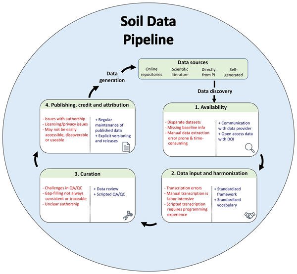
Katherine E. O. Todd-Brown, Rose Z. Abramoff, Jeffrey Beem-Miller, Hava K. Blair, Stevan Earl, Kristen J. Frederick, Daniel R. Fuka, Mario Guevara Santamaria, Jennifer W. Harden, Katherine Heckman, Lillian J. Heran, James R. Holmquist, Alison M. Hoyt, David H. Klinges, David S. LeBauer, Avni Malhotra, Shelby C. McClelland, Lucas E. Nave, Katherine S. Rocci, Sean M. Schaeffer, Shane Stoner, Natasja van Gestel, Sophie F. von Fromm, and Marisa L. Younger
Biogeosciences, 19, 3505–3522, https://doi.org/10.5194/bg-19-3505-2022, https://doi.org/10.5194/bg-19-3505-2022, 2022
Short summary
Short summary
Research data are becoming increasingly available online with tantalizing possibilities for reanalysis. However harmonizing data from different sources remains challenging. Using the soils community as an example, we walked through the various strategies that researchers currently use to integrate datasets for reanalysis. We find that manual data transcription is still extremely common and that there is a critical need for community-supported informatics tools like vocabularies and ontologies.
Cited articles
Abbaszadeh, P., Moradkhani, H., Gavahi, K., Kumar, S., Hain, C., Zhan, X., Duan, Q., Peters-Lidard, C., and Karimiziarani, S.: High-resolution SMAP satellite soil moisture product: Exploring the opportunities, Bull. Am. Meteorol. Soc., 102, E1209–E1221, 2021.
Arnold, J. G., Moriasi, D. N., Gassman, P. W., Abbaspour, K. C., White, M. J., Srinivasan, R., Santhi, C., Harmel, R. D., Van Griensven, A., and Van Liew, M. W.: SWAT: Model use, calibration, and validation, Trans. ASABE, 55, 1491–1508, 2012.
Asfaw, B. W., Fuka, D. R., Collick, A. S., White, R. R., and Easton, Z. M.: Characterizing the topographic index as a tool to represent spatial soil moisture: The effect of classification approach, digital elevation model type, and resolution, Vadose Zone J., 24, e70031, https://doi.org/10.1002/vzj2.70031, 2025.
Azimi, S., Dariane, A. B., Modanesi, S., Bauer‐Marschallinger, B., Bindlish, R., Wagner, W., and Massari, C.: Assimilation of Sentinel-1 and SMAP-based satellite soil moisture retrievals into SWAT hydrological model: The impact of satellite revisit time and product spatial resolution on flood simulations in small basins, J. Hydrol., 581, 124367, https://doi.org/10.1016/j.jhydrol.2019.124367, 2020.
Bekele, E. G. and Nicklow, J. W.: Multi-objective automatic calibration of SWAT using NSGA-II, J. Hydrol., 341, 165–176, https://doi.org/10.1016/j.jhydrol.2007.05.014, 2007.
Beven, K.: Prophecy, reality and uncertainty in distributed hydrological modelling, Adv. Water Resour., 16, 41–51, https://doi.org/10.1016/0309-1708(93)90028-E, 1993.
Beven, K. J., Kirkby, M. J., Freer, J. E., and Lamb, R.: A history of TOPMODEL, Hydrol. Earth Syst. Sci., 25, 527–549, https://doi.org/10.5194/hess-25-527-2021, 2021.
Blank, J. and Deb, K.: Pymoo: Multi-objective optimization in Python, IEEE Access, 8, 89497–89509, https://doi.org/10.1109/ACCESS.2020.2990567, 2020.
Bocinsky, R. K., Beaudette, D., Chamberlain, S., Hollister, J., and Gustavsen, J.: FedData: Download Geospatial Data Available from Several Federated Data Sources, Version 4.3.0, CRAN, https://cran.r-project.org/package=FedData (last access: May 2025), 2025.
Brocca, L., Melone, F., Moramarco, T., and Morbidelli, R.: Spatial-temporal variability of soil moisture and its estimation across scales, Water Resour. Res., 46, W02516, https://doi.org/10.1029/2009WR008016, 2010.
Brocca, L., Ciabatta, L., Massari, C., Camici, S., and Tarpanelli, A.: Soil moisture for hydrological applications: Open questions and new opportunities, Water, 9, 140, https://doi.org/10.3390/w9020140, 2017.
Buchanan, B., Auerbach, D. A., Knighton, J., Evensen, D., Fuka, D. R., Easton, Z. M., Wieczorek, M., Archibald, J. A., McWilliams, B., and Walter, M. T.: Estimating dominant runoff modes across the conterminous United States, Hydrol. Process., 32, 3888–3900, https://doi.org/10.1002/hyp.13296, 2018.
Buell, E. N.: Improved Environmental Characterization to Support Natural Resource Decision Making: (1) Distributed Soil Characterization and (2) Treatment of Legacy Nutrients, PhD dissertation, Virginia Polytechnic Institute and State University, Blacksburg, VA, USA, http://hdl.handle.net/10919/112013 (last access: November 2025), 2022.
Chan, S. K., Bindlish, R., O'Neill, P., Jackson, T., Njoku, E., Dunbar, S., Chaubell, J., Piepmeier, J., Yueh, S., Entekhabi, D., Colliander, A., Chen, F., Cosh, M. H., Caldwell, T., Walker, J., Berg, A., McNairn, H., Thibeault, M., Martínez-Fernández, J., Uldall, F., Seyfried, M., Bosch, D., Starks, P., Holifield Collins, C., Prueger, J., van der Velde, R., Asanuma, J., Palecki, M., Small, E. E., Zreda, M., Calvet, J., Crow, W. T., and Kerr, Y.: Development and assessment of the SMAP enhanced passive soil moisture product, Remote Sens. Environ., 204, 931–941, https://doi.org/10.1016/j.rse.2017.08.025, 2018.
Cho, E., Moon, H., and Choi, M.: First assessment of the Advanced Microwave Scanning Radiometer 2 (AMSR2) soil moisture contents in Northeast Asia, J. Meteorol. Soc. Jpn., 93, 117–129, https://doi.org/10.2151/jmsj.2015-008, 2015.
Colliander, A., Jackson, T. J., Bindlish, R., Chan, S., Das, N., Kim, S. B., Cosh, M. H., Dunbar, R. S., Dang, L., Pashaian, L., Asanuma, J., Aida, K., Berg, A., Rowlandson, T., Bosch, D., Caldwell, T., Caylor, K., Goodrich, D., Al Jassar, H., Lopez-Baeza, E., Martínez-Fernández, J., González-Zamora, A., Livingston, S., McNairn, H., Pacheco, A., Moghaddam, M., Montzka, C., Notarnicola, C., Niedrist, G., Pellarin, T., Prueger, J., Pulliainen, J., Rautiainen, K., Ramos, J., Seyfried, M., Starks, P., Su, Z., Zeng, Y., van der Velde, R., Thibeault, M., Dorigo, W., Vreugdenhil, M., Walker, J. P., Wu, X., Monerris, A., O'Neill, P. E., Entekhabi, D., Njoku, E. G., and Yueh, S.: Validation of SMAP surface soil moisture products with core validation sites, Remote Sens. Environ., 191, 215–231, https://doi.org/10.1016/j.rse.2017.01.021, 2017.
Dahlke, H. E., Easton, Z. M., Fuka, D. R., Lyon, S. W., and Steenhuis, T. S.: Modelling variable source area dynamics in a CEAP watershed, Ecohydrology, 2, 337–349, https://doi.org/10.1002/eco.58, 2009.
Dangol, S., Zhang, X., Liang, X.-Z., Anderson, M., Crow, W., Lee, S., Moglen, G. E., and McCarty, G. W.: Multivariate calibration of the SWAT model using remotely sensed datasets, Remote Sens., 15, 2417, https://doi.org/10.3390/rs15092417, 2023.
Das, N. N., Entekhabi, D., Kim, S., Jagdhuber, T., Dunbar, S., Yueh, S., O'Neill, P. E., Colliander, A., Walker, J., and Jackson, T. J.: High-resolution enhanced product based on SMAP active-passive approach using Sentinel-1A and 1B SAR data, Int. Arch. Photogramm. Remote Sens. Spatial Inf. Sci., XLII-5, 203–205, https://doi.org/10.5194/isprs-archives-XLII-5-203-2018, 2018.
Deb, K., Agrawal, S., Pratap, A., and Meyarivan, T.: A fast elitist non-dominated sorting genetic algorithm for multi-objective optimization: NSGA-II, in: Parallel Problem Solving from Nature PPSN VI, Springer, Berlin, Heidelberg, 849–858, https://doi.org/10.1007/3-540-45356-3_83, 2000.
De Santis, D., Biondi, D., Crow, W. T., Camici, S., Modanesi, S., Brocca, L., and Massari, C.: Assimilation of satellite soil moisture products for river flow prediction: An extensive experiment in over 700 catchments throughout Europe, Water Resour. Res., 57, e2021WR029643, https://doi.org/10.1029/2021WR029643, 2021.
Duethmann, D., Smith, A., Soulsby, C., Kleine, L., Wagner, W., Hahn, S., and Tetzlaff, D.: Evaluating satellite-derived soil moisture data for improving the internal consistency of process-based ecohydrological modelling, J. Hydrol., 614, 128462, https://doi.org/10.1016/j.jhydrol.2022.128462, 2022.
Easton, Z. M., Fuka, D. R., Walter, M. T., Cowan, D. M., Schneiderman, E. M., and Steenhuis, T. S.: Re-conceptualizing the Soil and Water Assessment Tool (SWAT) model to predict runoff from variable source areas, J. Hydrol., 348, 279–291, https://doi.org/10.1016/j.jhydrol.2007.10.008, 2008.
Eini, M. R., Massari, C., and Piniewski, M.: Satellite-based soil moisture enhances the reliability of agro-hydrological modeling in large transboundary river basins, Sci. Total Environ., 873, 162396, https://doi.org/10.1016/j.scitotenv.2023.162396, 2023.
Entekhabi, D., Reichle, R. H., Koster, R. D., and Crow, W. T.: Performance metrics for soil moisture retrievals and application requirements, J. Hydrometeorol., 11, 832–840, https://doi.org/10.1175/2010JHM1223.1, 2010.
Entekhabi, D., Yueh, S., and de Lannoy, G.: SMAP Handbook, Jet Propulsion Laboratory, California Institute of Technology, Pasadena, CA, USA, https://smap.jpl.nasa.gov/ (last access: May 2025), 2014.
Eumesat H SAF: ASCAT Surface Soil Moisture Climate Data Record v7 12.5 km sampling – Metop, EUMETSAT [data set], https://doi.org/10.15770/EUM_SAF_H_0009, 2021.
Food and Agriculture Organization of the United Nations (FAO): FAO Digital Soil Map of the World (DSMW), FAO, Rome, Italy, https://www.fao.org/land-water/land/land-governance/land-resources-planning-toolbox/category/details/en/c/1026564/ (last access: March 2025), 2007.
Fuka, D. R. and Easton, Z. M.: TopoSWAT Source, Figshare [data set], https://doi.org/10.6084/m9.figshare.1342823.v4, 2016.
Fuka, D. R., Walter, M. T., Archibald, J. A., Garna, R. K., and Easton, Z. M.: EcoHydRology: A Community Modeling Foundation for EcoHydrology, Version 0.4.19, R package, https://CRAN.R-project.org/package=EcoHydRology (last access: March 2025), 2013.
Fuka, D. R., Collick, A. S., Kleinman, P. J. A., Auerbach, D. A., Harmel, R. D., and Easton, Z. M.: Improving the spatial representation of soil properties and hydrology using topographically derived initialization processes in the SWAT model, Hydrol. Process., 30, 1589–1603, https://doi.org/10.1002/hyp.10899, 2016.
Garna, R. K., Easton, Z. M., Faulkner, J. W., Collick, A. S., and Fuka, D. R.: Employing higher density lower reliability weather data from the Global Historical Climatology Network monitors to generate serially complete weather data for watershed modelling, Hydrol. Process., 37, e15013, https://doi.org/10.1002/hyp.15013, 2023.
Gupta, H. V., Kling, H., Yilmaz, K. K., and Martinez, G. F.: Decomposition of the mean squared error and NSE performance criteria: Implications for improving hydrological modelling, J. Hydrol., 377, 80–91, https://doi.org/10.1016/j.jhydrol.2009.08.003, 2009.
Han, L., Wang, C., Liu, Q., Wang, G., Yu, T., Gu, X., and Zhang, Y.: Soil moisture mapping based on multi-source fusion of optical, near-infrared, thermal infrared, and digital elevation model data via the Bayesian maximum entropy framework, Remote Sens., 12, 3916, https://doi.org/10.3390/rs12233916, 2020.
Hofmeister, K. L., Cianfrani, C. M., and Hession, W. C.: Complexities in the stream temperature regime of a small mixed-use watershed, Blacksburg, VA, Ecol. Eng., 78, 101–111, https://doi.org/10.1016/j.ecoleng.2014.05.019, 2015.
H SAF: ASCAT Surface Soil Moisture Climate Data Record v7, 12.5 km Sampling, Metop, EUMETSAT SAF on Support to Operational Hydrology and Water Management, https://doi.org/10.15770/EUM_SAF_H_0009, 2021.
Jin, S., Dewitz, J., Danielson, P., Granneman, B., Costello, C., Smith, K., and Zhu, Z.: National Land Cover Database 2019: A new strategy for creating clean leaf-on and leaf-off Landsat composite images, J. Remote Sens., 3, 0022, https://doi.org/10.34133/remotesensing.0022, 2023.
Ketabchy, M.: Thermal Evaluation of an Urbanized Watershed Using SWMM and MINUHET: A Case Study of Stroubles Creek Watershed, Blacksburg, VA, MSc thesis, Virginia Polytechnic Institute and State University, Blacksburg, VA, USA, https://vtechworks.lib.vt.edu/handle/10919/81977 (last access: February 2025), 2018.
Kofidou, M. and Gemitzi, A.: Assimilating soil moisture information to improve the performance of the SWAT hydrological model, Hydrology, 10, 176, https://doi.org/10.3390/hydrology10080176, 2023.
Krause, P., Boyle, D. P., and Bäse, F.: Comparison of different efficiency criteria for hydrological model assessment, Adv. Geosci., 5, 89–97, https://doi.org/10.5194/adgeo-5-89-2005, 2005.
Kumar, S. and Merwade, V.: Impact of watershed subdivision and soil data resolution on SWAT model calibration and parameter uncertainty, JAWRA J. Am. Water Resour. Assoc., 45, 1179–1196, https://doi.org/10.1111/j.1752-1688.2009.00353.x, 2009.
Kundu, D., Vervoort, R. W., and van Ogtrop, F. F.: The value of remotely sensed surface soil moisture for model calibration using SWAT, Hydrol. Process., 31, 2764–2780, https://doi.org/10.1002/hyp.11219, 2017.
López López, P., Sutanudjaja, E. H., Schellekens, J., Sterk, G., and Bierkens, M. F. P.: Calibration of a large-scale hydrological model using satellite-based soil moisture and evapotranspiration products, Hydrol. Earth Syst. Sci., 21, 3125–3144, https://doi.org/10.5194/hess-21-3125-2017, 2017.
Lyon, S. W., Walter, M. T., Gérard-Marchant, P., and Steenhuis, T. S.: Using a topographic index to distribute variable source area runoff predicted with the SCS curve-number equation, Hydrol. Process., 18, 2757–2771, https://doi.org/10.1002/hyp.1494, 2004.
Mascaro, G., Vivoni, E. R., and Deidda, R.: Soil moisture downscaling across climate regions and its emergent properties, J. Geophys. Res.-Atmos., 116, D22114, https://doi.org/10.1029/2011JD016231, 2011.
Mei, Y., Mai, J., Do, H. X., Gronewold, A., Reeves, H., Eberts, S., Niswonger, R., Regan, R. S., and Hunt, R. J.: Can hydrological models benefit from using global soil moisture, evapotranspiration, and runoff products as calibration targets? Water Resour. Res., 59, e2022WR032064, https://doi.org/10.1029/2022WR032064, 2023.
Mladenova, I. E., Bolten, J. D., Crow, W., Sazib, N., and Reynolds, C.: Agricultural drought monitoring via the assimilation of SMAP soil moisture retrievals into a global soil water balance model, Front. Big Data, 3, 10, https://doi.org/10.3389/fdata.2020.00010, 2020.
Moore, C. and Doherty, J.: Role of the calibration process in reducing model predictive error, Water Resour. Res., 41, W05020, https://doi.org/10.1029/2004WR003501, 2005.
Moriasi, D. N., Arnold, J. G., Van Liew, M. W., Bingner, R. L., Harmel, R. D., and Veith, T. L.: Model evaluation guidelines for systematic quantification of accuracy in watershed simulations, Trans. ASABE, 50, 885–900, 2007.
Mullen, K. M., Ardia, D., Gil, D. L., Windover, D., and Cline, J.: DEoptim: An R package for global optimization by differential evolution, J. Stat. Softw., 40, 1–26, https://doi.org/10.18637/jss.v040.i06, 2011.
Nanda, A., Jalilvand, E., Das, N. N., Bindlish, R., and Andreadis, K.: Optimizing hydrologic model soil physical properties with SMAP soil moisture: A pathway for skillful assessment of streamflow and drought, SSRN Electron. J. [preprint], https://doi.org/10.2139/ssrn.4635449, 2023.
Nash, J. E. and Sutcliffe, J. V.: River flow forecasting through conceptual models. Part I: A discussion of principles, J. Hydrol., 10, 282–290, https://doi.org/10.1016/0022-1694(70)90255-6, 1970.
Nathan, R. J. and McMahon, T. A.: Evaluation of automated techniques for baseflow and recession analyses, Water Resour. Res., 26, 1465–1473, https://doi.org/10.1029/WR026i007p01465, 1990.
Nayeb Yazdi, M., Ketabchy, M., Sample, D. J., Scott, D., and Liao, H.: An evaluation of HSPF and SWMM for simulating streamflow regimes in an urban watershed, Environ. Model. Softw., 118, 211–225, https://doi.org/10.1016/j.envsoft.2019.05.008, 2019.
Neitsch, S. L., Arnold, J. G., Kiniry, J. R., and Williams, J. R.: Soil and Water Assessment Tool Theoretical Documentation, Version 2009, Texas Water Resources Institute, Texas A&M University System, College Station, TX, USA, https://swat.tamu.edu/docs/ (last access: February 2025), 2009.
O'Neill, P. E., Chan, S., Njoku, E. G., Jackson, T., Bindlish, R., and Chaubell, J.: SMAP L3 Radiometer Global Daily 36 km EASE-Grid Soil Moisture, Version 5, NASA National Snow and Ice Data Center Distributed Active Archive Center [data set], Boulder, CO, USA, https://doi.org/10.5067/ZX7YX2Y2LHEB, 2018.
O'Neill, P. E., Chan, S., Njoku, E. G., Jackson, T., Bindlish, R., Chaubell, J., and Colliander, A.: SMAP Enhanced L3 Radiometer Global and Polar Grid Daily 9 km EASE-Grid Soil Moisture, NASA National Snow and Ice Data Center Distributed Active Archive Center (NSIDC DAAC) [data set], Boulder, CO, USA, https://doi.org/10.5067/M20OXIZHY3RJ, 2023.
Parece, T., Dibetitto, S., Sprague, T., and Younos, T.: The Stroubles Creek Watershed: History of Development and Chronicles of Research, Virginia Water Resources Research Center, Virginia Polytechnic Institute and State University, Blacksburg, VA, USA, VWRRC Special Report SR48-2010, https://vtechworks.lib.vt.edu/items/1dc044f4-d58d-4ce7-abbb-e9a6cc4f0447 (last access: 18 September 2026), 2010.
Patil, A. and Ramsankaran, R.: Improving streamflow simulations and forecasting performance of SWAT model by assimilating remotely sensed soil moisture observations, J. Hydrol., 555, 683–696, https://doi.org/10.1016/j.jhydrol.2017.10.058, 2017.
Pechlivanidis, I. G., Jackson, B. M., McIntyre, N. R., and Wheater, H. S.: Catchment-scale hydrological modelling: A review of model types, calibration approaches and uncertainty analysis methods in the context of recent developments in technology and applications, Global NEST J., 13, 193–214, 2011.
Peng, Y., Yang, Z., Zhang, Z., and Huang, J.: A machine learning-based high-resolution soil moisture mapping and spatial-temporal analysis: The mlhrsm package, Agronomy, 14, 421, https://doi.org/10.3390/agronomy14030421, 2024.
Rajib, M. A. and Merwade, V.: Improving soil moisture accounting and streamflow prediction in SWAT by incorporating a modified time-dependent Curve Number method, Hydrol. Process., 30, 603–624, https://doi.org/10.1002/hyp.10639, 2016.
Rajib, M. A., Merwade, V., and Yu, Z.: Multi-objective calibration of a hydrologic model using spatially distributed remotely sensed/in-situ soil moisture, J. Hydrol., 536, 192–207, https://doi.org/10.1016/j.jhydrol.2016.02.037, 2016.
Sanford, W. E., Nelms, D. L., Pope, J. P., and Selnick, D. L.: Quantifying Components of the Hydrologic Cycle in Virginia Using Chemical Hydrograph Separation and Multiple Regression Analysis, Scientific Investigations Report 2011-5198, U.S. Geological Survey, https://doi.org/10.3133/sir20115198, 2012.
Silvestro, F., Gabellani, S., Rudari, R., Delogu, F., Laiolo, P., and Boni, G.: Uncertainty reduction and parameter estimation of a distributed hydrological model with ground and remote-sensing data, Hydrol. Earth Syst. Sci., 19, 1727–1751, https://doi.org/10.5194/hess-19-1727-2015, 2015.
Sun, L.: Streamflow and Soil Moisture Assimilation in the SWAT Model Using the Extended Kalman Filter, PhD dissertation, University of Regina, Regina, Saskatchewan, Canada, https://doi.org/10.20381/RUOR-4934, 2016.
Thilakarathne, M., Sridhar, V., and Karthikeyan, R.: Spatially explicit pollutant load-integrated in-stream E. coli concentration modeling in a mixed land-use catchment, Water Res., 144, 87–103, https://doi.org/10.1016/j.watres.2018.07.021, 2018.
Vereecken, H., Huisman, J. A., Hendricks Franssen, H. J., Brüggemann, N., Bogena, H. R., Kollet, S., Javaux, M., van der Kruk, J., and Vanderborght, J.: Soil hydrology: Recent methodological advances, challenges, and perspectives, Water Resour. Res., 51, 2616–2633, https://doi.org/10.1002/2014WR016852, 2015.
Wagner, W., Lemoine, G., and Rott, H.: A method for estimating soil moisture from ERS scatterometer and soil data, Remote Sens. Environ., 70, 191–207, https://doi.org/10.1016/S0034-4257(99)00036-X, 1999.
Wagner, W., Blöschl, G., Pampaloni, P., Calvet, J.-C., Bizzarri, B., Wigneron, J.-P., and Kerr, Y.: Operational readiness of microwave remote sensing of soil moisture for hydrologic applications, Hydrol. Res., 38, 1–20, 2007.
Wakigari, S. A. and Leconte, R.: Exploring the utility of the downscaled SMAP soil moisture products in improving streamflow simulation, J. Hydrol. Reg. Stud., 47, 101380, https://doi.org/10.1016/j.ejrh.2023.101380, 2023.
Xu, Y., Cai, S., Huang, J., Liu, J., Shang, J., Yang, Z., and Zhang, Z.: A multimodal deep learning approach for soil moisture downscaling using remote sensing and weather data, J. Geophys. Res.-Mach. Learn. Comput., 2, e2025JH000639, https://doi.org/10.1029/2025JH000639, 2025.
Zeileis, A., Grothendieck, G., Ryan, J. A., Ulrich, J. M., and Andrews, F.: zoo: S3 Infrastructure for Regular and Irregular Time Series (Z's Ordered Observations), Version 1.8-14, CRAN, https://cran.r-project.org/package=zoo (last access: August 2025), 2025.
Short summary
We investigated the use of downscaled and bias-corrected satellite soil‑moisture data to inform hydrologic model calibration beyond traditional streamflow‑based approaches. Incorporating soil moisture improved representation of internal moisture dynamics without degrading streamflow performance. The study illustrates how satellite soil moisture can help constrain hydrologic models while emphasizing the importance of model structure.
We investigated the use of downscaled and bias-corrected satellite soil‑moisture data to...


