
Articles | Volume 30, issue 14
https://doi.org/10.5194/hess-30-4587-2026
© Author(s) 2026. This work is distributed under
the Creative Commons Attribution 4.0 License.
the Creative Commons Attribution 4.0 License.
https://doi.org/10.5194/hess-30-4587-2026
© Author(s) 2026. This work is distributed under
the Creative Commons Attribution 4.0 License.
the Creative Commons Attribution 4.0 License.
Research article
| 
21 Jul 2026
Research article |
| 21 Jul 2026
| 21 Jul 2026
Proposing sources for discrete groundwater discharges to patterned pools in three regional raised northern peat bogs
Henry E. Moore
CORRESPONDING AUTHOR

Department of Earth, and Environmental Sciences, Rutgers University Newark, 101 Warren St. Smith Hall – Room 135 Newark, NJ 07102, United States of America
Xavier Comas
Florida Atlantic University, Department of Geosciences, 777 Glades Road, Boca Raton, FL 33431, United States of America
Martin A. Briggs
U.S. Geological Survey, Observing Systems Division, Hydrologic Remote Sensing Branch, 11 Sherman Place, Unit 5015, Storrs, CT 06269, United States of America
Andrew S. Reeve
University of Maine, School of Earth and Climate Sciences, 5790 Bryand Global Sciences Center, Orono, ME 04469-5790, United States of America
Khondaker Md. Nur Alam
Department of Earth, and Environmental Sciences, Rutgers University Newark, 101 Warren St. Smith Hall – Room 135 Newark, NJ 07102, United States of America
Lee Slater
Department of Earth, and Environmental Sciences, Rutgers University Newark, 101 Warren St. Smith Hall – Room 135 Newark, NJ 07102, United States of America
Pacific Northwest National Laboratory, 902 Battelle Blvd, Richland, WA 99354 United States of America
Related authors
No articles found.
Joshua Howard Thompson, Dimitrios Ntarlagiannis, and Lee Slater
EGUsphere, https://doi.org/10.5194/egusphere-2025-2434, https://doi.org/10.5194/egusphere-2025-2434, 2025
Short summary
Short summary
The field-scale geophysical surveys can identify soil texture variations that are assumed to indicate localized regions of rapid groundwater flux, and by extension subsurface nutrient transport. Our results show jointly using geophysical methods significantly improves the accuracy of soil maps identifying areas where nutrients are likely to be transported via subsurface pathways.
Martin A. Briggs, Phillip Goodling, Zachary C. Johnson, Karli M. Rogers, Nathaniel P. Hitt, Jennifer B. Fair, and Craig D. Snyder
Hydrol. Earth Syst. Sci., 26, 3989–4011, https://doi.org/10.5194/hess-26-3989-2022, https://doi.org/10.5194/hess-26-3989-2022, 2022
Short summary
Short summary
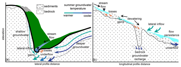
The geologic structure of mountain watersheds may control how groundwater and streamwater exchange, influencing where streams dry. We measured bedrock depth at 191 locations along eight headwater streams paired with stream temperature records, baseflow separation and observations of channel dewatering. The data indicated a prevalence of shallow bedrock generally less than 3 m depth, and local variation in that depth can drive stream dewatering but also influence stream baseflow supply.
Cited articles
Ala-aho, P.: Groundwater–surface water interactions in esker aquifers: From field measurements to fully integrated numerical modelling, PhD thesis, University of Oulu, Oulu, Finland, https://oulurepo.oulu.fi/bitstream/handle/10024/35828/isbn978-952-62-0658-5.pdf?sequence=1 (last access: 6 July 2026), 2014.
Anderson, M. P.: Heat as a ground water tracer, Ground Water, 43, 951–968, https://doi.org/10.1111/j.1745-6584.2005.00052.x, 2005.
Balliston, N. and Price, J. S.: Beyond fill and spill: Hydrological connectivity in a sub-arctic bog-fen-tributary complex in the Hudson Bay Lowlands, Canada, Hydrol. Process., 36, e14575, https://doi.org/10.1002/hyp.14575, 2022.
Balliston, N., Sutton, O., and Price, J.: Solute depletion and reduced hydrological connectivity in subarctic patterned peatlands disturbed by mine dewatering, Sci. Total Environ., 913, 169442, https://doi.org/10.1016/j.scitotenv.2023.169442, 2024.
Beckwith, C. W., Baird, A. J., and Heathwaite, A. L.: Anisotropy and depth-related heterogeneity of hydraulic conductivity in a bog peat, I: Laboratory measurements, Hydrol. Process., 17, 89–101, https://doi.org/10.1002/hyp.1116, 2003a.
Beckwith, C. W., Baird, A. J., and Heathwaite, A. L.: Anisotropy and depth-related heterogeneity of hydraulic conductivity in a bog peat, II: Modelling the effects on groundwater flow, Hydrol. Process., 17, 103–113, https://doi.org/10.1002/hyp.1117, 2003b.
Belyea, L. R.: Climatic and topographic limits to the abundance of bog pools, Hydrol. Process., 21, 675–687, https://doi.org/10.1002/hyp.6275, 2007.
Belyea, L. R. and Baird, A. J.: Beyond “The limits to peat bog growth”: Cross-scale feedback in peatland development, Ecol. Monogr., 76, 299–322, https://doi.org/10.1890/0012-9615(2006)076[0299:BTLTPB]2.0.CO;2, 2006.
Belyea, L. R. and Lancaster, J.: Inferring landscape dynamics of bog pools from scaling relationships and spatial patterns, J. Ecol., 90, 223–234, https://doi.org/10.1046/j.1365-2745.2001.00647.x, 2002.
Berthot, L., Pinti, D. L., Larocque, M., Gagné, S., Ferlatte, M., and Cloutier, V.: Exploring 222Rn as a tool for tracing groundwater inflows from eskers and moraines into slope peatlands of the Amos region of Quebec, Canada, J. Environ. Radioactiv., 164, 344–353, https://doi.org/10.1016/j.jenvrad.2016.07.038, 2016.
Boatman, D. J., Goode, D. A., and Hulme, P. D.: The Silver Flowe, III: Pattern development on Long Loch B and Craigeazle mires, J. Ecol., 69, 897–918, https://doi.org/10.2307/2259644, 1981.
Borns Jr., H. W.: Preliminary report on the age and distribution of the late Pleistocene ice in north-central Maine, Am. J. Sci., 261, 738–740, https://doi.org/10.2475/ajs.261.8.738, 1963.
Bourgault, M.-A., Larocque, M., and Garneau, M.: How do hydrogeological setting and meteorological conditions influence water table depth and fluctuations in ombrotrophic peatlands?, J. Hydrol. X, 4, 100032, https://doi.org/10.1016/j.hydroa.2019.100032, 2019.
Brunke, M. and Gonser, T.: The ecological significance of exchange processes between rivers and groundwater, Freshwater Biol., 37, 1–33, https://doi.org/10.1046/j.1365-2427.1997.00143.x, 1997.
Cameron, C. C.: Some peat deposits in Washington and southeastern Aroostook Counties, Maine, U.S. Geol. Surv. Bull., 1317-C, 1–26, https://doi.org/10.3133/b1317C, 1975.
Cameron, C. C., Mullen, M. K., Lepage, C. A., and Anderson, W. A.: Peat Resources of Maine, Volume 5: Washington County, Maine Geol. Surv. Bull., 32, 143 pp., 1984.
Chauhan, A., Patzner, M. S., Bhattacharyya, A., Borch, T., Fischer, S., Obst, M., ThomasArrigo, L. K., Kretzschmar, R., Mansor, M., Bryce, C., Kappler, A., and Joshi, P.: Interactions between iron and carbon in permafrost thaw ponds, Sci. Total Environ., 946, 174321, https://doi.org/10.1016/j.scitotenv.2024.174321, 2024.
Chen, X., Comas, X., Reeve, A. S., and Slater, L. D.: Evidence for glacial geological controls on the hydrology of Maine (USA) peatlands, Geology, 48, 771–776, https://doi.org/10.1130/G46844.1, 2020.
Comas, X. and Slater, L. D.: Low-frequency electrical properties of peat, Water Resour. Res., 40, W12414, https://doi.org/10.1029/2004WR003534, 2004.
Comas, X., Slater, L. D., and Reeve, A. S.: Geophysical evidence for peat basin morphology and stratigraphic controls on vegetation observed in a northern peatland, J. Hydrol., 295, 173–184, https://doi.org/10.1016/j.jhydrol.2004.03.008, 2004.
Comas, X., Slater, L. D., and Reeve, A. S.: Stratigraphic controls on pool formation in a domed bog inferred from ground-penetrating radar (GPR), J. Hydrol., 315, 40–51, https://doi.org/10.1016/j.jhydrol.2005.04.020, 2005.
Comas, X., Slater, L. D., and Reeve, A. S.: Pool patterning in a northern peatland: Geophysical evidence for the role of postglacial landforms, J. Hydrol., 399, 173–184, https://doi.org/10.1016/j.jhydrol.2010.12.031, 2011.
Constantz, J.: Heat as a tracer to determine streambed water exchanges, Water Resour. Res., 44, W00D10, https://doi.org/10.1029/2008WR006996, 2008.
Cox, M. H., Su, G. W., and Constantz, J.: Heat, chloride, and specific conductance as ground water tracers near streams, Ground Water, 45, 187–195, https://doi.org/10.1111/j.1745-6584.2006.00276.x, 2007.
Davis, R. B. and Anderson, D. S.: The Eccentric Bogs of Maine: A Rare Wetland Type in the United States, Maine State Planning Office, Critical Areas Program, Planning Rep. 93, Tech. Bull. 146, https://www.cabidigitallibrary.org/doi/full/10.5555/19921966477 (last access: 16 May 2024), 1991.
Davis, R. B. and Anderson, D. S.: A numerical method and supporting database for evaluation of Maine peatlands as candidate natural areas, Maine Agric. For. Exp. Stn. Tech. Bull., 175, 68–175, 1999.
Erickson, M. L., Yager, R. M., Kauffman, L. J., and Wilson, J. T.: Drinking water quality in the glacial aquifer system, northern USA, Sci. Total Environ., 694, 133735, https://doi.org/10.1016/j.scitotenv.2019.133735, 2019.
Foster, D. R. and Fritz, S. C.: Mire development, pool formation, and landscape processes on patterned fens in Dalarna, central Sweden, J. Ecol., 75, 409–437, https://doi.org/10.2307/2260426, 1987.
Foster, D. R. and Glaser, P. H.: The raised bogs of south-eastern Labrador, Canada: Classification, distribution, vegetation and recent dynamics, J. Ecol., 74, 47–71, https://doi.org/10.2307/2260348, 1986.
Foster, D. R. and Wright Jr., H. E.: Role of ecosystem development and climate change in bog formation in central Sweden, Ecology, 71, 450–463, https://doi.org/10.2307/1940300, 1990.
Foster, D. R., King, G. A., Glaser, P. H., and Wright Jr., H. E.: Origin of string patterns in boreal peatlands, Nature, 306, 256–258, https://doi.org/10.1038/306256a0, 1983.
Foster, D. R., Wright Jr., H. E., Thelaus, M., and King, G. A.: Bog development and landform dynamics in central Sweden and south-eastern Labrador, Canada, J. Ecol., 76, 1164–1185, https://doi.org/10.2307/2260641, 1988.
Glaser, P. H.: Vegetation and water chemistry, in: Patterned Peatlands of Northern Minnesota, edited by: Wright Jr., H. E. and Coffin, B. A., University of Minnesota Press, Minneapolis, MN, USA, 15–26, ISBN 9781452903057, 1992.
Glaser, P. H. and Janssens, J. A.: Raised bogs in eastern North America: Transitions in landforms and gross stratigraphy, Can. J. Bot., 64, 395–415, https://doi.org/10.1139/b86-056, 1986.
Glaser, P. H., Wheeler, G. A., Gorham, E., and Wright Jr., H. E.: The patterned mires of the Red Lake Peatland, northern Minnesota: Vegetation, water chemistry, and landforms, J. Ecol., 69, 575–599, https://doi.org/10.2307/2259685, 1981.
Glaser, P. H., Siegel, D. I., Romanowicz, E. A., and Shen, Y. P.: Regional linkages between raised bogs and the climate, groundwater, and landscape of north-western Minnesota, J. Ecol., 85, 3–16, https://doi.org/10.2307/2960623, 1997.
Gorham, E.: The development of peatlands, Q. Rev. Biol., 32, 145–166, https://doi.org/10.1086/401755, 1957.
Groschen, G. E., Arnold, T. L., Morrow, W. S., and Warner, K. L.: Occurrence and distribution of iron, manganese, and selected trace elements in ground water in the glacial aquifer system of the northern United States, U.S. Geol. Surv. Sci. Investig. Rep., 2009–5006, 89 pp., 2009.
Hare, D. K., Boutt, D. F., Clement, W. P., Hatch, C. E., Davenport, G., and Hackman, A.: Hydrogeological controls on spatial patterns of groundwater discharge in peatlands, Hydrol. Earth Syst. Sci., 21, 6031–6048, https://doi.org/10.5194/hess-21-6031-2017, 2017.
Hare, D. K., Helton, A. M., Johnson, Z. C., Lane, J. W., and Briggs, M. A.: Continental-scale analysis of shallow and deep groundwater contributions to streams, Nat. Commun., 12, 1450, https://doi.org/10.1038/s41467-021-21651-0, 2021.
Hayashi, M.: Temperature–electrical conductivity relation of water for environmental monitoring and geophysical data inversion, Environ. Monit. Assess., 96, 119–128, https://doi.org/10.1023/B:EMAS.0000031719.83065.68, 2004.
Hebrand, M. and Åmark, M.: Esker formation and glacier dynamics in eastern Skåne and adjacent areas, southern Sweden, Boreas, 18, 67–81, https://doi.org/10.1111/j.1502-3885.1989.tb00372.x, 1989.
Holden, J. and Burt, T. P.: Piping and pipeflow in a deep peat catchment, Catena, 48, 163–199, https://doi.org/10.1016/S0341-8162(01)00189-8, 2002.
Holden, J., Burt, T. P., and Cox, N. J.: Macroporosity and infiltration in a blanket peat: The implications of tension disc infiltrometer measurements, Hydrol. Process., 15, 289–303, https://doi.org/10.1002/hyp.93, 2001.
Ingram, H. A. P.: Size and shape in raised mire ecosystems: A geophysical model, Nature, 297, 300–303, https://doi.org/10.1038/297300a0, 1982.
Lambert, C., Larocque, M., Gagné, S., and Garneau, M.: Aquifer–peatland hydrological connectivity and controlling factors in boreal peatlands, Front. Earth Sci., 10, 835817, https://doi.org/10.3389/feart.2022.835817, 2022.
Lyford, F. P., Stone, J. R., Nielsen, J. P., and Hansen, B. P.: Geohydrology and ground-water quality, Eastern Surplus Superfund Site, Meddybemps, Maine, U.S. Geol. Surv. Water-Resour. Investig. Rep., 98–4174, 76 pp., 1998.
Lowry, C. S., Fratta, D., and Anderson, M. P.: Ground-penetrating radar and spring formation in a groundwater-dominated peat wetland, J. Hydrol., 373, 68–79, https://doi.org/10.1016/j.jhydrol.2009.04.023, 2009.
McCarter, C. P. R. and Price, J. S.: Experimental hydrological forcing to illustrate water flow processes of a subarctic ladder fen peatland, Hydrol. Process., 31, 1578–1589, https://doi.org/10.1002/hyp.11127, 2017.
Miller, P., Shaw, G. H., Glaser, P. H., and Siegel, D. I.: Bedrock topography beneath the Red Lake Peatlands, Geological Society of America Annual Meeting, Cincinnati, OH, USA, October 1992, Abstracts with Programs, https://www.osti.gov/biblio/5808031 (last access: 16 May 2024), 1992.
Moore, H., Comas, X., Briggs, M. A., Reeve, A. S., Alam, K. M. N., Slater, L.: Minerogenous Groundwater Inputs to Patterned Pools in Northern Raised Peat Bogs Supplementary Data, HydroShare [data set], http://www.hydroshare.org/resource/8877eb61207c4ae28b66231b450efa0d (last access: 16 September 2024), 2024.
Moore, H. E., Comas, X., Briggs, M. A., Reeve, A. S., and Slater, L. D.: Indications of preferential groundwater seepage feeding northern peatland pools, J. Hydrol., 638, 131479, https://doi.org/10.1016/j.jhydrol.2024.131479, 2024.
Moore, P. D.: Stratigraphy and pollen analysis of Claish Moss, north-west Scotland: Significance for the origin of surface-pools and forest history, J. Ecol., 65, 375–397, https://doi.org/10.2307/2259489, 1977.
Moore, P. D.: Pool and ridge patterns in peat mires, Nature, 300, 110, https://doi.org/10.1038/300110c0, 1982.
National Oceanic and Atmospheric Administration (NOAA): Record of Climatological Observations, August 2023, Station COOPER 0.5 SE, ME US (US1MEWS0004), Cooper, Maine, USA, National Centers for Environmental Information, https://www.ncei.noaa.gov/cdo-web/ (last access: 17 February 2024), 2023a.
National Oceanic and Atmospheric Administration (NOAA): Record of Climatological Observations, June 2023, Station COOPER 0.5 SE, ME US (US1MEWS0004), Cooper, Maine, USA, National Centers for Environmental Information, https://www.ncei.noaa.gov/cdo-web/ (last access: 17 February 2024), 2023b.
National Oceanic and Atmospheric Administration (NOAA): Record of Climatological Observations, August 2023, Station HOULTON 2.2 SW, ME US (US1MEAR0040), Houlton, Maine, USA, National Centers for Environmental Information, https://www.ncei.noaa.gov/cdo-web/ (last access: 17 February 2024), 2023c.
National Oceanic and Atmospheric Administration (NOAA): Record of Climatological Observations, June 2023, Station ORONO 1.1 SSW, ME US (US1MEPN0055), Orono, Maine, USA, National Centers for Environmental Information, https://www.ncei.noaa.gov/cdo-web/ (last access: 17 February 2024), 2023d.
National Oceanic and Atmospheric Administration (NOAA): Record of Climatological Observations, August 2024, Station 25 COOPER 0.5 SE, ME US (US1MEWS0004), Cooper, Maine, USA, National Centers for Environmental Information, https://www.ncei.noaa.gov/cdo-web/ (last access: 17 February 2024), 2024.
Newman, W. A.: Reconnaissance surficial geology of the Sherman Quadrangle, Maine, Maine Geological Survey, Department of Conservation, Open-File Rep. 80–17, https://digitalmaine.com/mgs_maps/636/ (last access: 16 May 2024), 1980.
Olid, C., Rodellas, V., Rocher-Ros, G., Garcia-Orellana, J., Diego-Feliu, M., Alorda-Kleinglass, A., and Karlsson, J.: Groundwater discharge as a driver of methane emissions from Arctic lakes, Nat. Commun., 13, 3667, https://doi.org/10.1038/s41467-022-31219-1, 2022.
Orlova, J. and Branfireun, B. A.: Surface water and groundwater contributions to streamflow in the James Bay Lowland, Canada, Arct. Antarct. Alp. Res., 46, 236–250, https://doi.org/10.1657/1938-4246-46.1.236, 2014.
Osberg, P. H., Hussey II, A. M., and Boone, G. M.: Bedrock geologic map of Maine, scale 1 : 500 000, Maine Geological Survey, Department of Conservation, Augusta, ME, USA, https://digitalmaine.com/mgs_maps/23/ (last access: 16 May 2024), 1985.
Osborne, C., Gilbert-Parkes, S., Spiers, G., Lamit, L. J., Lilleskov, E. A., Basiliko, N., and Watmough, S.: Global patterns of metal and other element enrichment in bog and fen peatlands, Arch. Environ. Contam. Toxicol., 86, 125–139, https://doi.org/10.1007/s00244-024-01051-3, 2024.
Plattner, A. M.: GPRPy: Open-source ground-penetrating radar processing and visualization software, Lead. Edge, 39, 332–337, https://doi.org/10.1190/tle39050332.1, 2020.
QGIS.org: QGIS Geographic Information System, QGIS Association, https://www.qgis.org/ (last access: 16 May 2024), 2023.
Quillet, A., Larocque, M., Pellerin, S., Cloutier, V., Ferlatte, M., Paniconi, C., and Bourgault, M.-A.: The role of hydrogeological setting in two Canadian peatlands investigated through 2D steady-state groundwater flow modelling, Hydrol. Sci. J., 62, 2541–2557, https://doi.org/10.1080/02626667.2017.1391387, 2017.
Quinton, W. L. and Roulet, N. T.: Spring and summer runoff hydrology of a subarctic patterned wetland, Arct. Alp. Res., 30, 285–294, https://doi.org/10.2307/1551976, 1998.
Reeve, A. S., Siegel, D. I., and Glaser, P. H.: Simulating vertical flow in large peatlands, J. Hydrol., 227, 207–217, https://doi.org/10.1016/S0022-1694(99)00183-3, 2000.
Reeve, A. S., Tyczka, Z. D., Comas, X., and Slater, L. D.: The influence of permeable mineral lenses on peatland hydrology, in: Carbon Cycling in Northern Peatlands, Geophysical Monograph Series, 184, American Geophysical Union, Washington, DC, 163–177, https://doi.org/10.1029/GM184, 2009.
Rezanezhad, F., Quinton, W. L., Price, J. S., Elliot, T. R., Elrick, D., and Shook, K. R.: Influence of pore size and geometry on peat unsaturated hydraulic conductivity computed from 3D computed tomography image analysis, Hydrol. Process., 24, 2983–2994, https://doi.org/10.1002/hyp.7709, 2010.
Rossi, P. M., Ala-aho, P., Ronkanen, A. K., and Kløve, B.: Groundwater–surface water interaction between an esker aquifer and a drained fen, J. Hydrol., 432–433, 52–60, https://doi.org/10.1016/j.jhydrol.2012.02.026, 2012.
Roy, D. C.: Reconnaissance bedrock geology of the Sherman, Mattawamkeag, and Millinocket 150 quadrangles, Maine, Maine Geological Survey, Augusta, ME, USA, https://digitalmaine.com/mgs_maps/317/ (last access: 16 May 2024), 1981.
Roy, D. C., Demarest, N. A., and Hill, M. J.: Stratigraphy and sedimentation in Silurian flysch east of Millinocket, Maine, in: The Greenville–Millinocket Regions, North Central Maine, New England Intercollegiate Geological Conference Guidebook, 75th Annual Meeting, edited by: Caldwell, D. W. and Hanson, L. S., 123–145, https://scholars.unh.edu/neigc/45/ (last access: 16 May 2024), 1983.
Shreve, R. L.: Esker characteristics in terms of glacier physics, Katahdin esker system, Maine, Geol. Soc. Am. Bull., 96, 639–646, https://doi.org/10.1130/0016-7606(1985)96<639:ECITOG>2.0.CO;2, 1985.
Siegel, D. I.: Hydrogeologic setting of the Glacial Lake Agassiz peatlands, northern Minnesota, U.S. Geol. Surv. Water-Resour. Investig. Rep. 81–24, https://pubs.usgs.gov/wri/1981/0024/report.pdf (last access: 16 May 2024), 1981.
Siegel, D. I.: Ground water and the evolution of patterned mires, Glacial Lake Agassiz peatlands, northern Minnesota, J. Ecol., 71, 913–921, https://doi.org/10.2307/2259601, 1983.
Siegel, D. I.: Groundwater hydrology, in: Patterned Peatlands of Northern Minnesota, edited by: Wright Jr., H. E. and Coffin, B. A., University of Minnesota Press, Minneapolis, MN, USA, 163–172, ISBN 9781452903057, 1992.
Siegel, D. I. and Glaser, P. H.: Groundwater flow in a bog-fen complex, Lost River Peatland, northern Minnesota, J. Ecol., 75, 743–754, https://doi.org/10.2307/2260203, 1987.
Siegel, D. I. and Glaser, P. H.: The hydrology of peatlands, in: Boreal Peatland Ecosystems, Ecological Studies, Vol. 188, Springer, Berlin, Heidelberg, 289–311, https://doi.org/10.1007/978-3-540-31913-9_13, 2006.
Siegel, D. I., Reeve, A. S., Glaser, P. H., and Romanowicz, E. A.: Climate-driven flushing of pore water in peatlands, Nature, 374, 531–533, https://doi.org/10.1038/374531a0, 1995.
Slater, L. and Reeve, A.: Investigating peatland stratigraphy and hydrogeology using integrated electrical geophysics, Geophysics, 67, 365–378, https://doi.org/10.1190/1.1468597, 2002.
Smart, P. J.: Stratigraphy of a site in the Munsary Dubh Lochs, Caithness, northern Scotland: Development of present pattern, J. Ecol., 70, 549–559, https://doi.org/10.2307/2259922, 1982.
Sorensen, J. A. and Glass, G. E.: Ion and temperature dependence of electrical conductance for natural waters, Anal. Chem., 59, 1594–1597, https://doi.org/10.1021/ac00140a003, 1987.
Spence, C. and Woo, M.-K.: Hydrology of subarctic Canadian Shield: soil-filled valleys, J. Hydrol., 279, 151–166, https://doi.org/10.1016/S0022-1694(03)00175-6, 2003.
State of Maine: Maine GeoLibrary Data Catalog: Maine Elevation Contours (2 ft), Maine GeoLibrary, https://www.maine.gov/geolib/catalog.html (last access: 16 May 2024), 2020.
Teledyne FLIR: Teledyne FLIR Tools / FLIR Tools+ (Version 6.4), Teledyne FLIR [code], https://www.flir.com/de-de/products/flir-tools/ (last access: 16 May 2024), 2018.
Theimer, B. D.: Principles of bog characterization using ground penetrating radar, MSc thesis, University of Waterloo, Waterloo, ON, Canada, ISBN 0315725303, 1990.
Theimer, B. D., Nobes, D. C., and Warner, B. G.: A study of the geoelectrical properties of peatlands and their influence on ground-penetrating radar surveying, Geophys. Prospect., 42, 179–209, https://doi.org/10.1111/j.1365-2478.1994.tb00205.x, 1994.
Thompson, W. B. and Borns, H. W.: Surficial geologic map of Maine, scale 1 : 500 000, Maine Geological Survey, Department of Conservation, Augusta, ME, USA, https://digitalmaine.com/mgs_maps/15/ (last access: 16 May 2024), 1985.
Trenberth, K. E.: Changes in precipitation with climate change, Clim. Res., 47, 123–138, https://doi.org/10.3354/cr00953, 2011.
Turner, T. E., Billett, M. F., Baird, A. J., Chapman, P. J., Dinsmore, K. J., and Holden, J.: Regional variation in the biogeochemical and physical characteristics of natural peatland pools, Sci. Total Environ., 545–546, 84–94, https://doi.org/10.1016/j.scitotenv.2015.12.101, 2016.
Winter, T. C., Harvey, J. W., Franke, O. L., and Alley, W. M.: The hydrologic cycle and interactions of ground water and surface water, in: Ground Water and Surface Water: A Single Resource, U.S. Geological Survey Circular 1139, 2–20, https://pubs.usgs.gov/circ/1998/1139/report.pdf (last access: 16 May 2024), 1998.
Short summary
This study of three peat bogs in Maine, USA suggests surface pools receive groundwater from depth based on interactions with the underlying sediments. Geophysical surveys mapped sediments, while thermal imaging paired with point temperature and water conductivity measurements revealed local patterns pointing to groundwater sources. Such discrete inflows may accelerate peat decomposition and carbon loss.
This study of three peat bogs in Maine, USA suggests surface pools receive groundwater from...


