the Creative Commons Attribution 4.0 License.
the Creative Commons Attribution 4.0 License.
 | 09 Oct 2025
Soil salinity patterns reveal changes in the water cycle of inland river basins in arid zones
Gaojia Meng
Yinying Jiao
Dongdong Qiu
Yuhao Wang
Siyu Lu
Rui Li
Jiawei Liu
Longhu Chen
Qinqin Wang
Enwei Huang
Wentong Li
Soil salinization caused by unreasonable water resource utilization severely impacts agricultural development and ecological construction in arid inland river basins. Therefore, clarifying the water cycle mechanism of salinization in arid inland river basins is crucial for watershed ecological environment management and rational water resource utilization. Based on remote sensing and observational data, this study quantitatively analyzed soil salinization changes in the Shiyang River basin of Northwest China's arid region from 2002 to 2022 and explored the impacts of water conservancy projects and agricultural irrigation on soil salinization. The results indicated that (1) the salinization area of the Shiyang River basin remains stable overall, but the degree of salinization is further intensifying; (2) the northern hills and oasis–desert transition zone of the Shiyang River are regions with severe salinization problems, while the central corridor plain and southern Qilian Mountain regions have lower risks of salinization; (3) regional salinization problems are particularly prominent, caused by groundwater evaporation near reservoirs, agricultural irrigation evaporation, and downstream ecological water input evaporation. Human activities have become the decisive factor in changing the salinization pattern of inland river basins, and rational utilization and management of water resources hold tremendous potential in mitigating soil salinization.
- Article
(9217 KB) - Full-text XML
- BibTeX
- EndNote


Land is an essential natural resource for human beings, with economic, social, and ecological benefits in various production activities (Lambin and Meyfroidt, 2011; Chen et al., 2023). Soil serves as the foundation of natural ecosystems, capable of facilitating material and energy cycling within the system and maintaining interactive relationships with the biosphere, hydrosphere, and atmosphere (Seneviratne et al., 2010; Smith et al., 2015; Lehmann et al., 2020). Soil plays a critical role in promoting plant growth, regulating precipitation infiltration and distribution to coordinate watershed water cycles. Moreover, its purification capacity enables the decomposition of potential pollutants, thereby preventing water and air pollution to a certain extent (Bünemann et al., 2018; Renshu et al., 2024). However, once soil quality declines or undergoes degradation, it can cause irreversible damage and directly impact human life (Reynolds et al., 2007; Abu Hammad and Tumeizi, 2012). Soil salinization is a critical factor in land degradation (Kramer and Mau, 2020). Its fundamental mechanism involves groundwater rising to the surface, where, under high-temperature conditions, water evaporates from soil pores into the atmosphere, causing salt deposits to precipitate on the ground surface. Prolonged salt accumulation can adversely affect crop growth, ultimately leading to reduced yields and other negative consequences (Zörb et al., 2018; Folberth et al., 2016; Mao et al., 2022).
Soil salinization can be classified into primary salinization and secondary salinization based on its causes (Liang et al., 2018). Primary salinization is mainly influenced by natural factors, while secondary soil salinization is caused by human activities (Kaushal et al., 2005; Zhuang et al., 2021; Perri et al., 2022). In particular, improper agricultural irrigation increases the risk of elevated groundwater salinity, creating a significant challenge for fields such as hydrology and agriculture (Sharma and Minhas, 2005). Artificial water transfer projects significantly alter the connectivity between groundwater and soil water, making the trend of salt enrichment through evaporation to the surface more pronounced. Seasonal water reservoir storage can also impact soil water salinity in watersheds. Estimates suggest that global saline soil area has already exceeded 833 ×106 ha, with approximately 20 % of agricultural land and 33 % of irrigated farmland becoming salinized soils, and this situation is expected to deteriorate further (Tian et al., 2020; Hassani et al., 2021; Xiao et al., 2023). In arid inland river basins, the climate is extremely dry, with high soil and plant evaporation intensity and elevated groundwater levels. The degree of soil salinization is severe, with a larger affected area, particularly in Northwest China's inland regions, where salinized cultivated land accounts for nearly one-fifth of the country's total cultivated land area. Therefore, studying soil salinization in arid inland river basins is crucial for understanding watershed water cycle processes and mechanisms and holds significant importance for agricultural irrigation and water resource management (Wichelns and Qadir, 2015).
Remote sensing technology has been widely used to assess soil salinization, and feature spectral characteristics are essential markers for identifying saline soils (Ivushkin et al., 2019; Hu et al., 2024). There is a significant difference in reflectance between various soil salinity levels in the visible-light and near-infrared bands (Farifteh et al., 2007). Saline soils exhibit higher reflectance compared to non-saline soils and show absorption peaks in the visible-light band (Zhang and Huang, 2019). There is a positive correlation between soil reflectance and soil salinization (Metternicht and Zinck, 2003; El Harti et al., 2016; Lotfollahi et al., 2023). Saline soils show absorption peaks in the visible band, and there is a positive correlation between their soil reflectance and soil salinity. In global-scale soil salinization research, researchers have employed machine learning methods to dynamically monitor surface soil salinity over the last 40 years (Hassani et al., 2020). In the context of global climate change, machine learning (ML) algorithms are used to predict soil salinization in the 21st century (Hassani et al., 2021). Research results indicate that salt-affected regions are primarily distributed in arid and semi-arid areas, with particular severity in Northwest China (Li et al., 2014). Due to unique climatic conditions and the influences of irrigation, drainage, and ecological water transfer, the salinization risk has further intensified in China's arid and semi-arid zones (Wang and Jia, 2012; Cañedo-Argüelles et al., 2013). The complex relationship between soil salinization and groundwater changes exacerbates regional water–salt imbalances. Irrigated agriculture carries salt through water and percolates it into groundwater layers, leading to increased groundwater salinity and subsequently triggering soil salinization in irrigation areas (Foster et al., 2018). Moreover, with the continuous expansion of agricultural land, the excessive development of land resources has produced profound and persistent impacts on soil salinization (Wang and Li, 2013).
The Shiyang River basin is located in the arid northwest of China, representing a typical inland river system, with its soil salinization problem progressively worsening due to water infrastructure and irrigation activities. Therefore, assessing the distribution of soil salinization in this basin is crucial for understanding how natural and human activities impact soil salinization in arid areas. In this study, we aim to do the following: (1) quantitatively analyze the degree of salinization in the Shiyang River basin and reveal its spatial and temporal distribution characteristics and (2) analyze the impacts of water cycle changes on salinization. The study's results will help clarify the impact of the water cycle on soil salinization in the inland river basin and will provide a scientific basis for agricultural development, ecological construction, and water resource use planning in the arid zone.
2.1 The background conditions of the study area
The Shiyang River basin is located in Northwest China, at the eastern end of the Hexi Corridor. It consists of eight major tributaries: the Dajing River, the Gulang River, the Huangyang River, the Zamu River, the Jinta River, and the Xiying River (Fig. 1). Lakes and wetlands in the whole region mainly exist in reservoirs, with 15 reservoirs built with a capacity of more than 1 ×10⁶ m3. Water storage in reservoirs helps to adjust the distribution of river water. The study area is located in the BWK climate zone under the Köppen–Geiger climate classification, which is a cold arid desert climate (Beck et al., 2018, 2023). It features strong solar radiation, intense evaporation, significant diurnal temperature variation, and an annual average temperature below 8 °C. Precipitation is sparse and primarily influenced by westerlies and monsoons. Mountain areas receive more precipitation than plains, with higher precipitation during summer and autumn and significantly less during winter and spring. The terrain slopes from southwest to northeast and is divided into three units. The bedrock of the southern Qilian Mountains consists of metamorphosed sandstones and volcanic rocks, with soil textures that are predominantly coarse and medium, including Cryosols, Leptosols, and Phaeozems (IUSS Working Group WRB, 2022). The land is primarily forest and grassland, with annual precipitation of 300–600 mm and evaporation rates of 700–1200 mm, and the groundwater level is 50–200 m below the surface. The central corridor plain features bedrock composed of schist and slate, with soil textures that are predominantly medium and fine, including Gypsisols, Calcisols, and Solonchaks. The land use is primarily agricultural, with annual precipitation of 150–300 mm and evaporation rates of 1300–2000 mm, and the groundwater level is 15–50 m below the surface. The bedrock of the northern hills and oasis–desert transition zone is predominantly igneous rock, with soil textures that are mainly coarse, including Arenosols, Leptosols, and Solonchaks. The landscape is barren, with annual precipitation below 150 mm and evaporation rates of 2000–3000 mm, and the groundwater level is 10–30 m below the surface. The three geomorphological units show distinct differences, with increasing aridity from south to north.
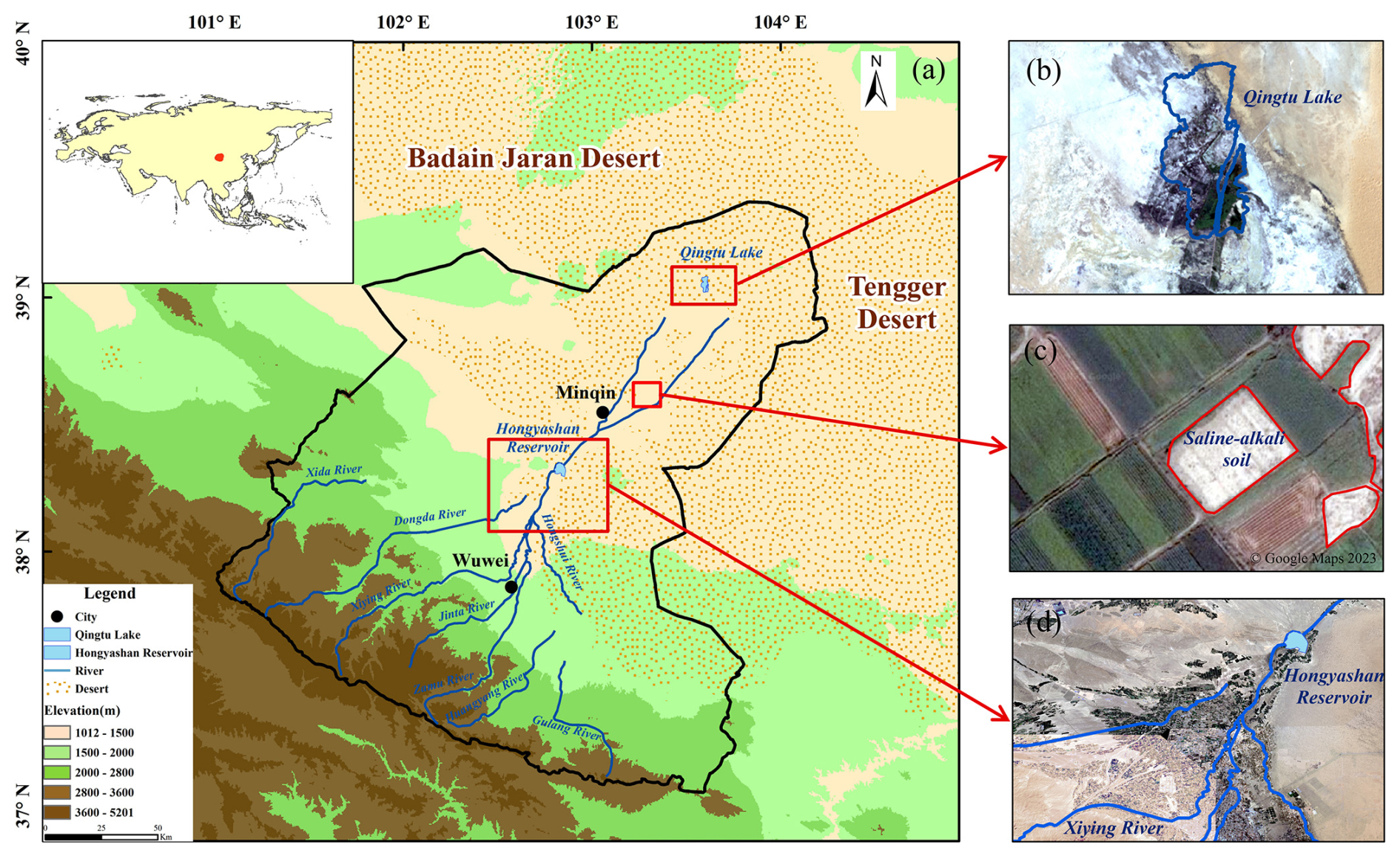
Figure 1Overview map of the study area. (a) Location distribution map of the Shiyang River basin. (b) Qingtu Lake (from USGS). (c) Saline soils in agricultural land (from © Google Maps). (d) Distribution of water systems in the Shiyang River basin (from USGS).
2.2 Data sources
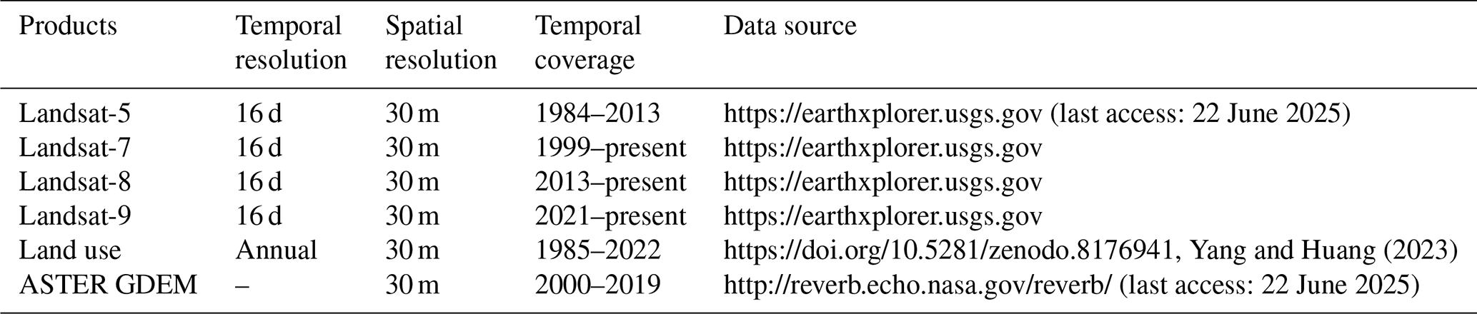
2.2.1 Remote sensing data
The Landsat series from the United States is jointly managed by the National Aeronautics and Space Administration (NASA) and the United States Geological Survey (USGS). It is a series of Earth observation satellite systems used by the US for monitoring Earth's resources and environment. Landsat is mainly used to investigate ocean resources and groundwater resources and to assist in regulating the rational use of water resources. Landsat data are available from the Earth Explorer service, which provides surface reflectance every 16 d with a spatial resolution of 30 m (Table 1). This article uses satellite data from Landsat-5, Landsat-7, Landsat-8, and Landsat-9. Landsat-5 was launched in March 1984, carrying the Multispectral Scanner (MSS) and Thematic Mapper (TM), and has provided nearly 29 years of Earth imaging data. Landsat-7 was launched in April 1999, carrying the Enhanced Thematic Mapper Plus (ETM+) and the scan line corrector (SLC) sensor. Since June 2003, this sensor has collected and transmitted data with gaps caused by the failure of the scan line corrector (SLC), providing better radiometric and geometric data. Landsat-8, launched in February 2013, carries the Operational Land Imager (OLI) and the Thermal Infrared Sensor (TIRS), ensuring the continuity of land data reception and availability. Its data are consistent with existing standard Landsat data products. The OLI sensor is used to capture remote sensing images in the visible, near-infrared, and shortwave infrared spectral ranges and is designed with a push-broom configuration, providing a better level and stability and resulting in higher-quality images. The OLI-2 sensor on Landsat-9 has a higher radiometric resolution, enabling finer detection in areas such as waterbodies and dense forests.
2.2.2 Land use data
This study obtained a land cover dataset for the Shiyang River basin at a 30 m resolution, covering the time period from 2002 to 2022 (Table 1).
2.2.3 Digital elevation model
The digital elevation model (DEM) data are derived from the ASTER GDEM dataset, jointly developed by Japan's METI and the US's NASA. The resolution is 30 m, and the slope data are calculated from the DEM data.
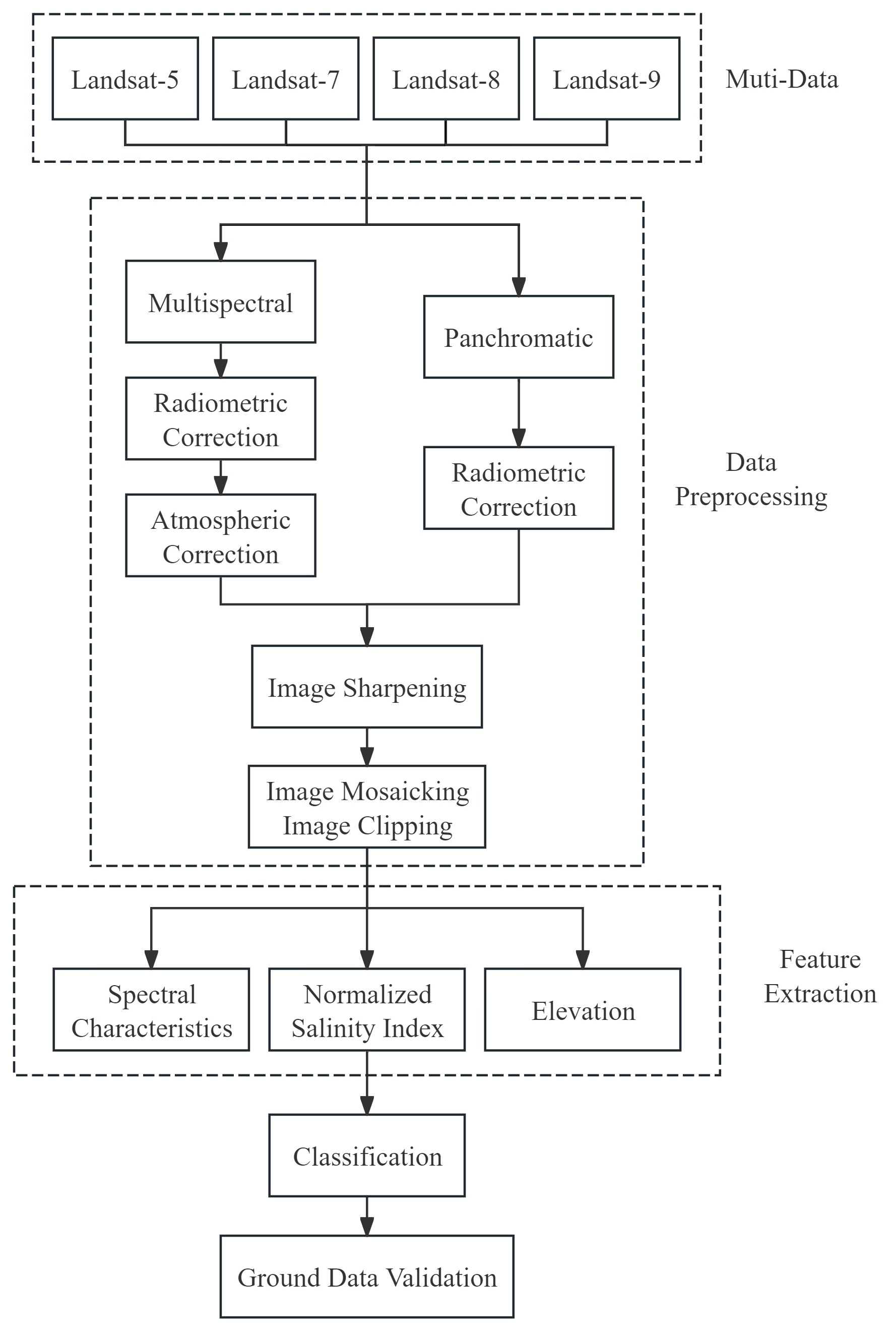
2.3 Data preparation and processing
This study selected 2002, 2007, 2012, 2017, and 2022 as research time nodes, with four satellite remote sensing images captured for each period. To ensure the quality of remote sensing images and salinization identification accuracy, we prioritized obtaining high-quality images with cloud cover of less than 1 % during summer, which is more conducive to identifying soil salinization levels (Allbed and Kumar, 2013). During the remote sensing image processing stage, we used ENVI (sourced from https://www.nv5geospatialsoftware.com/, lase access: June 22 2025) to preprocess the images, including radiometric calibration, atmospheric correction, image fusion, image mosaicking, and image clipping. Based on the natural properties of the study area's soil, auxiliary data, and field survey information, we selected interpretation marker points for mild, moderate, and severe saline lands, as well as other land types, using high-resolution Google Maps imagery. For saline land extraction, we adjusted the optimal band combination for satellite remote sensing images (Khan et al., 2005; Jia et al., 2024) and combined the normalized difference salinity index (NDSI), slope data, and texture features. We employed support vector machine algorithms for supervised classification of the study area to precisely identify the spatial distribution of saline lands. The formula is as follows:
In the formula, w represents the weight vector, which defines the direction of the hyperplane; b is the bias term, defining the offset of the hyperplane; ξi is the slack variable, which increases the robustness of the model; C is the regularization parameter, balancing the model complexity and training error; and yi is the label of data point i, commonly used to define a hyperplane.
Finally, the accuracy of the supervised classification results is evaluated using the confusion matrix method, including overall classification accuracy and the Kappa coefficient. The data processing flow is shown in Fig. 2.
2.4 Remote sensing data validation
2.4.1 Validation using soil salinity observation data
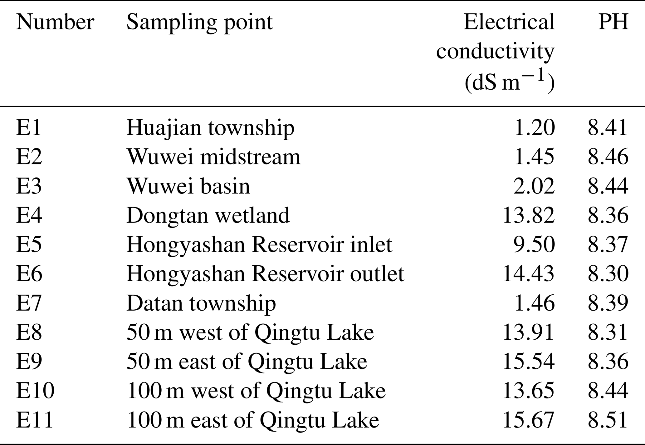
We selected 11 soil sampling sites within the Shiyang River basin during the period of 2019–2024. Through systematic field investigation and sampling, we measured the electrical conductivity and pH values of soil samples in the laboratory. The spatial distribution of sampling points and dataset validation points is illustrated in Fig. 3a, with the measured electrical conductivity and pH values meticulously recorded in Table 2. The measured electrical conductivity and pH values serve as ground truth data, forming a mutual verification relationship with remote sensing interpretation data. From the data, it can be observed that the electrical conductivity is high (13.65–15.67 dS m−1) in the wetland areas around Qingtu Lake and Hongyashan Reservoir in the northern part of the Shiyang River basin, while it is generally low (1.20–2.02 dS m−1) in the upstream areas at higher elevations. This spatial variation pattern is highly consistent with the salt characteristic features identified from the corresponding remote sensing image patches. The pH value ranges from 8.30 to 8.51, and its variation trend is consistent with the salt content variation.
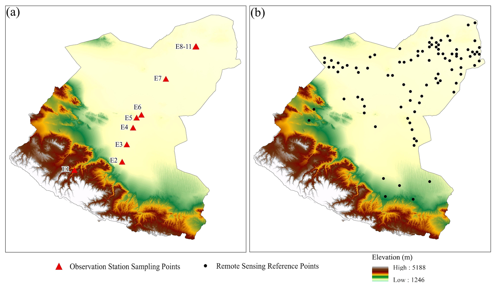
Figure 3Distribution of validation points in the Shiyang River basin.
2.4.2 Cross-validation of remote sensing data
We used the HWSD 2.0 data released by the Food and Agriculture Organization (FAO) and extracted the relevant data for our research area. Based on the salt–alkali patches currently identified by remote sensing, we selected 92 verification points and extracted their corresponding soil information (Fig. 3b). After verification, we found that, of these 92 verification points, 75 points were consistent with the interpretation results, resulting in an overall accuracy of 81.52 %.
2.4.3 Control experiment validation for the river basin
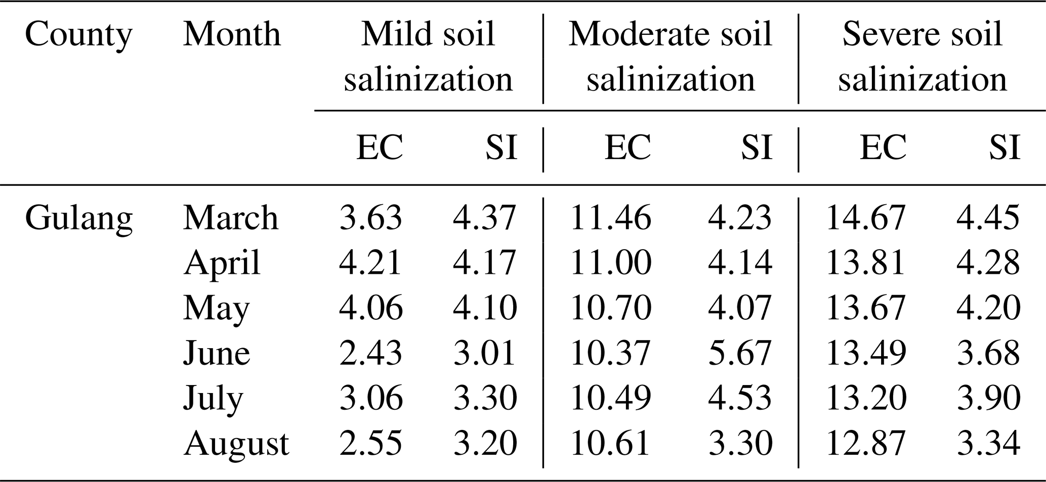
Field validation of the remote sensing data authenticity was conducted at the experimental field of Gulang County (Shiyang River Observation Station, Northwest Normal University) in 2024 (Fig. 4), with specific steps including the delineation of experimental plots, collection of soil samples, laboratory analysis to determine actual soil salinity, remote sensing monitoring of vegetation and salinity throughout the entire growing season, soil sampling throughout the entire growing season, and comparative analysis of remote sensing monitoring results and experimental data to assess their discrepancies and consistency. In the soil salinization area of Gulang County in the Shiyang River basin (Fig. 3), the electrical conductivity measurement values were compared with the salinization index (SI) (Table 3). The results demonstrated that the electrical conductivity changes in saline soil samples were consistent with remote sensing monitoring results, with a high correlation coefficient, indicating a significant correlation between the two and, thus, the reliability of the remote sensing monitoring technology used.
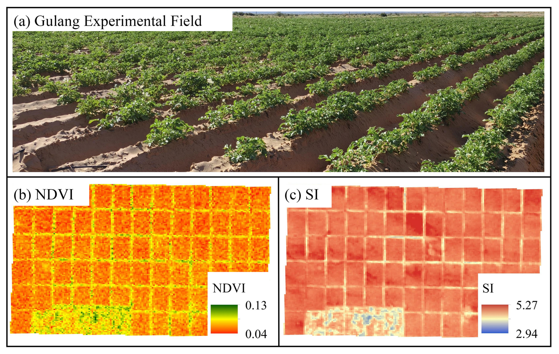
Table 3Soil sample electrical conductivity and SI comparison (EC units: dS m−1).
3.1 Spatial distribution of soil salinization
This study conducted remote sensing inversion of soil salinization in the Shiyang River basin from 2002 to 2022 (Fig. 5). The results showed that the salinization of the basin gradually increased from upstream to downstream, especially in the downstream area of the basin near Qingtu Lake, where the salinization of the soil was the most serious. From the perspective of natural landform division, the salt-accumulating areas of the Shiyang River basin are widely distributed across the central corridor plains, northern hills, and oasis–desert transition zone. In the central corridor plains, soil salinization is mainly characterized by mild and moderate salinization. Moderately saline soils are primarily concentrated in the oasis farmland irrigation areas on both sides of the river, with a few plots transforming into severe saline soils. In the northern hills and oasis–desert transition zone, soil salinization is mainly characterized by moderate and severe salinization, with the area and extent far exceeding those of the central corridor plains.
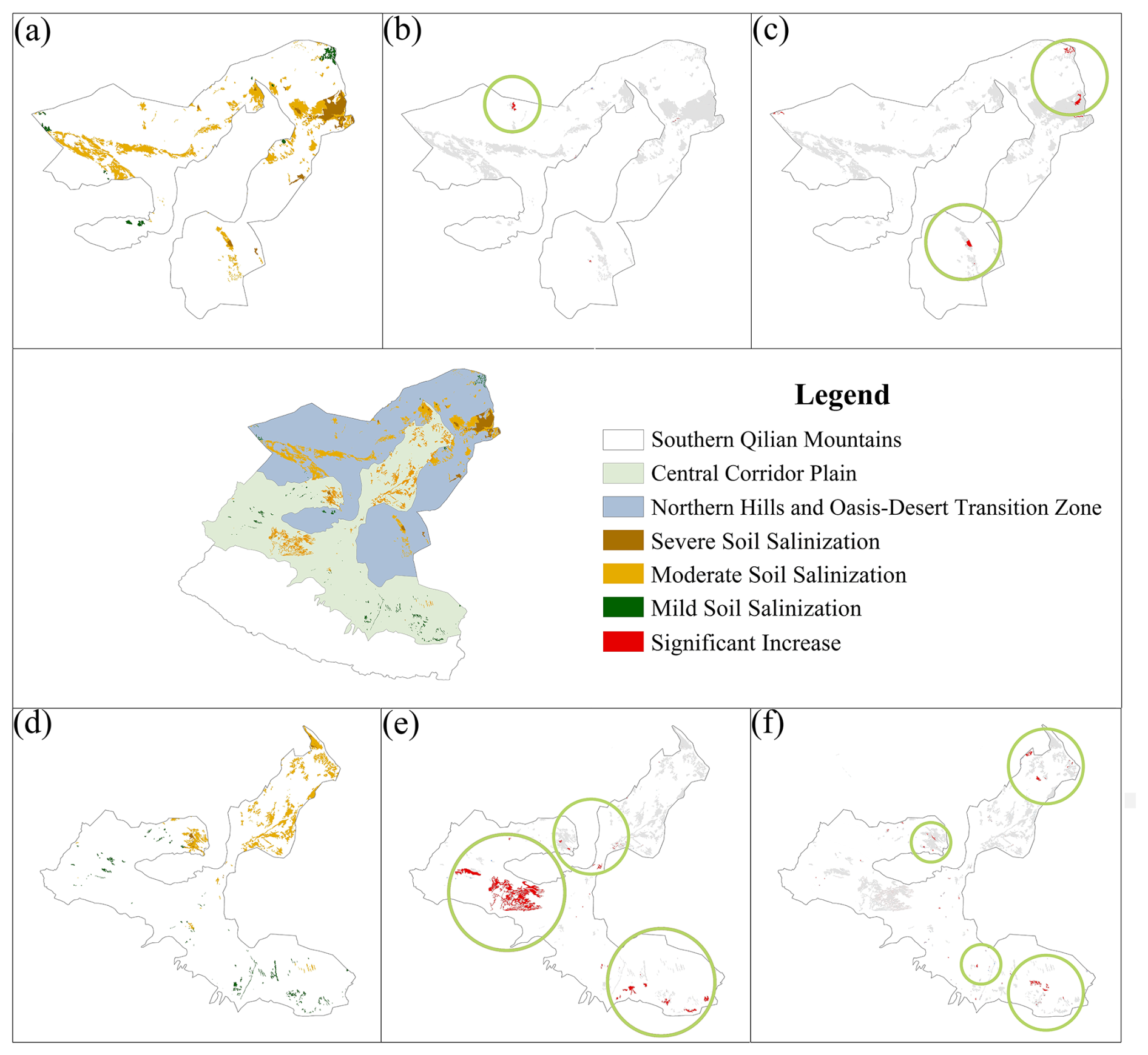
Figure 5Spatial distribution map of salinization in the Shiyang River basin. (a) Distribution of soil salinization in the northern hills and oasis–desert transition zone in 2002. (b–c) Expansion areas in soil salinization in the northern hills and oasis–desert transition zone in 2012 and 2022. (d) Distribution of soil salinization in the central corridor plain in 2002. (e–f) Expansion areas in soil salinization in the central corridor plain in 2012 and 2022.
3.2 Temporal changes in soil salinization
The study area is divided into three parts based on natural landform units. The southern Qilian Mountains area did not exhibit soil salinization, and so the study focused on analyzing the temporal changes in soil salinization area in the central corridor plains and the northern hills and oasis–desert transition zone (Fig. 6). From 2002 to 2022, the total soil salinization area in the Shiyang River basin showed an upward trend, with significant changes in its spatial distribution pattern. The salinization area decreased from 2002 to 2007, increased from 2007 to 2012, and then decreased again from 2017 to 2022. The central corridor plain of the Shiyang River basin experienced a significant increase in salinization area, with moderate salinization showing the most notable increase, while mild and severe salinization zones remained relatively stable. Compared to 2002, the soil salinization area in 2022 increased by over 18 %. The area of mild salinization reached its peak in 2017 and had decreased slightly by 2022. Moderate salinization area showed the most pronounced upward trend, while severe salinization area experienced minimal changes. In the northern hills and oasis–desert transition zone, overall, the soil salinization area demonstrated a downward trend, with an average annual decline rate of 38.19 km2. Mild salinization area increased slightly. Moderate salinization area decreased continuously, with the most significant reduction occurring between 2002 and 2007. Severe salinization area slowly decreased from 2002 to 2017 but increased from 2017 to 2022. Overall, the area of soil salinization increased in the central corridor plain, while it remained relatively stable in the northern hills and oasis–desert transition zone. The total soil salinization across the entire basin showed a slight overall increase.
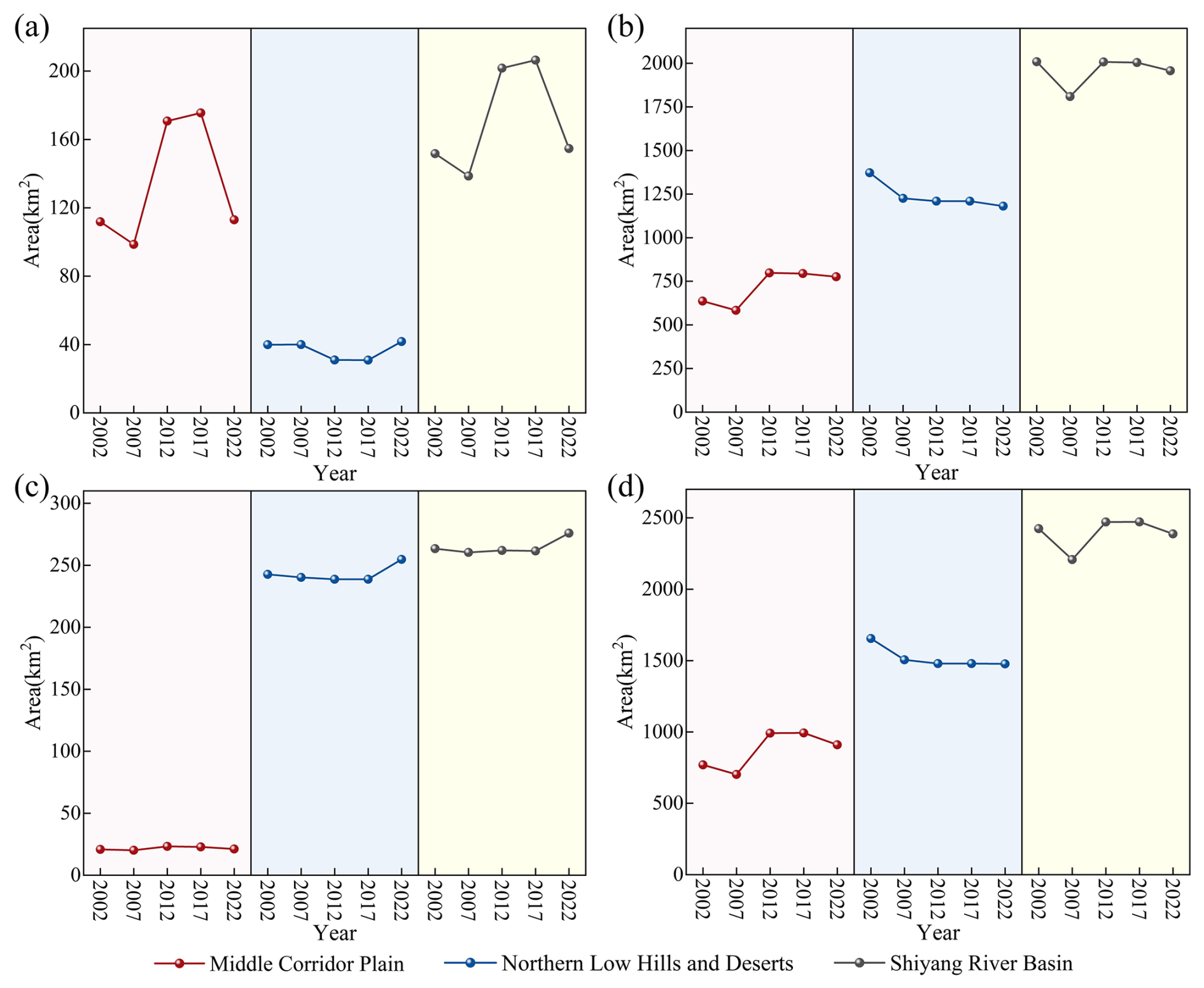
Figure 6Changes in soil salinization area in the Shiyang River basin. (a–d) Changes in areas of mild, moderate, severe, and total soil salinization in the Shiyang River basin.
4.1 Soil salinization and basin water conservancy project
The Shiyang River basin is a typical inland river basin whose geographical and climatic characteristics provide a unique background for studying salinization phenomena, making it an ideal area for researching salinization processes (Ji et al., 2006; Zhu et al., 2022). Long-term monitoring through multiple observation points in the basin has revealed that the salinization issue shows a tendency to worsen. As water diversion projects advance and water transfer volumes increase, agricultural irrigation water will inevitably increase significantly (Yang and Xu, 2023). The input of external water will necessarily disrupt the balanced state between regional soil, vegetation, and climate, thus requiring careful attention to salinization issues arising from agricultural irrigation (Abbas et al., 2013; Thorslund et al., 2021). In the long term, secondary salinization is poised to become the primary potential obstacle to sustainable inter-basin water transfer (Karimzadeh et al., 2024). Its negative effects are reflected in two aspects: the evaporation process altered by the introduced water for irrigation and the rise in groundwater level caused by the inflow of external water (Duan et al., 2022). The connectivity between groundwater and soil moisture increases, making the trend of salt concentration through evaporation to the surface more pronounced. In arid regions with low rainfall and high evaporation, this will lead to salt accumulation in the soil surface from dissolved salts (Aboelsoud et al., 2023). In the upstream region of the Shiyang River basin, natural water sources such as precipitation and snowmelt are introduced into irrigation districts (Zhu et al., 2022); the middle reaches improve water resource supply by constructing reservoirs and channels (Sang et al., 2023); the downstream region primarily relies on upstream Shiyang River water and ecological water transfers (Qiu et al., 2023). In the basin's ecological water transfer, water diversion from the Hongyashan Reservoir to Qingtu Lake is a crucial measure for adjusting irrigation water patterns (Fig. 7). The Jingdian Phase-II water diversion project started in 2001, continuously introducing Yellow River water into downstream areas. These water conservancy projects have, to some extent, effectively alleviated water resource constraints in the basin's downstream region but may lead to further accumulation of soil salinity.
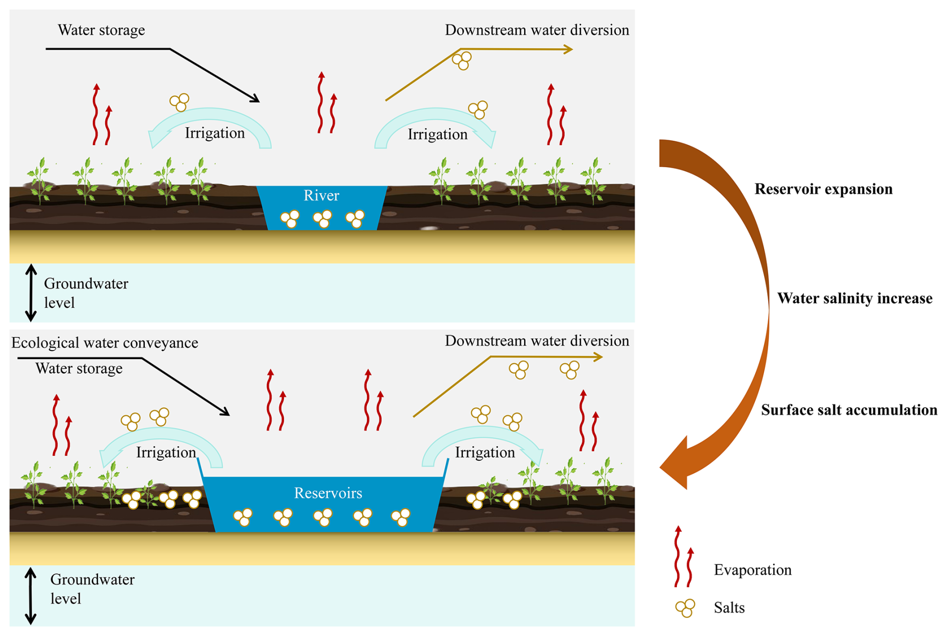
Reservoir construction is an important cause of soil salinization in surrounding agricultural lands (Wu et al., 2019). The Hongyashan Reservoir is located in the desert downstream of the basin, with its western side built against the Hongya Mountains and with other dams that have been artificially constructed. The reservoir aims to improve downstream ecological water scarcity, but, as the reservoir continues to expand further, the downstream water storage gradually declines. From 2002 to 2022, the soil salinization in areas surrounding the Hongyashan Reservoir gradually intensified (Fig. 8). In 2002, the reservoir area was relatively small, with severe and moderate soil salinization appearing in its western part, while some moderate soil salinization also emerged in the southeastern part. By 2007, water storage in the western part increased, and the salinization zone in the southeast shifted southward. In 2012, soil salinization in the southern part of the reservoir became severely acute, turning into severe salinization, and severe salinization also appeared in the southwestern region. From 2012 to 2022, the salinized area around the reservoir expanded further. Additionally, measurements of groundwater electrical conductivity in the Hongyashan Reservoir from 2017 to 2019 revealed that the electrical conductivity (EC) values consistently remained above 500 µs cm−1, with a slight upward trend in recent years, increasing by 14.119 µs cm−1 from 2017 to 2023. The increased groundwater salinity around the reservoir, combined with the extremely arid climate and low rainfall, intensifies surface water evaporation, leading to salt accumulation in the surface soil and gradually intensifying soil salinization (Yang et al., 2020; Yin et al., 2021).
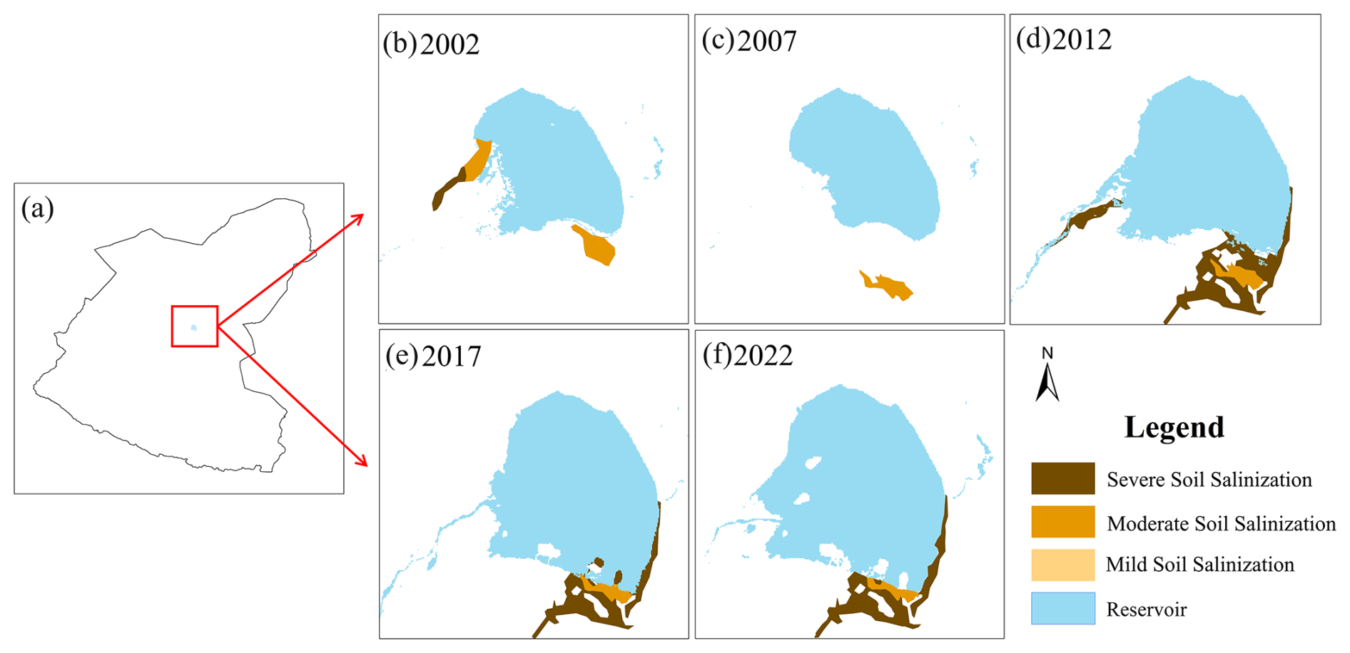
Figure 8Changes in waterbody area and surrounding soil salinization in Hongyashan Reservoir.
4.2 Soil salinization and irrigation
Developing irrigated agriculture is necessary to meet the continuously growing global food demand (Jägermeyr et al., 2017). In agricultural production, irrigation is a critical cause of salinization. Clarifying the relationship between salinization and irrigation and providing potential solutions is crucial. From 2002 to 2007, the basin's irrigation area increased from 5131.35 to 5381.58 km2, showing a significant upward trend, while the salinization area showed a contrary downward trend. From 2007 to 2012, the irrigation area decreased, but the basin's salinization area increased. From 2012 to 2017, the basin's irrigation area decreased notably by about 100 km2, while the salinization area remained relatively unchanged. From 2017 to 2022, the irrigation area rebounded significantly, exceeding 5300 km2, with a simultaneous substantial decline in salinization area. In the short term, an expansion of irrigation area is usually accompanied by a reduction in salinization area, while a decrease in irrigation area corresponds to an increase in salinization area. This phenomenon indicates that moderate irrigation can temporarily reduce salt concentration in the soil surface layer through leaching, alleviating soil salinization. However, from a long-term perspective, salinized lands in the Shiyang River basin are primarily distributed within irrigation areas, revealing another causal relationship between irrigation and salinization. Without scientific irrigation management, prolonged over-irrigation coupled with inadequate drainage systems leads to groundwater level rise, causing deep-layer salts to move upward, while dissolved salts in irrigation water accumulate in the soil through water evaporation (Minhas et al., 2020). This cumulative effect ultimately exacerbates soil salinization problems. From 2002 to 2022, the conversion rate of fallow land to saline land was 7.11 %, significantly higher than for grasslands (5.68 %) and cultivated lands (2.92 %). This difference highlights the critical role of continuous irrigation in suppressing soil salinization but also reveals that, without effective irrigation and salt elimination mechanisms, the region's agricultural ecosystem faces extremely high salinization risks.
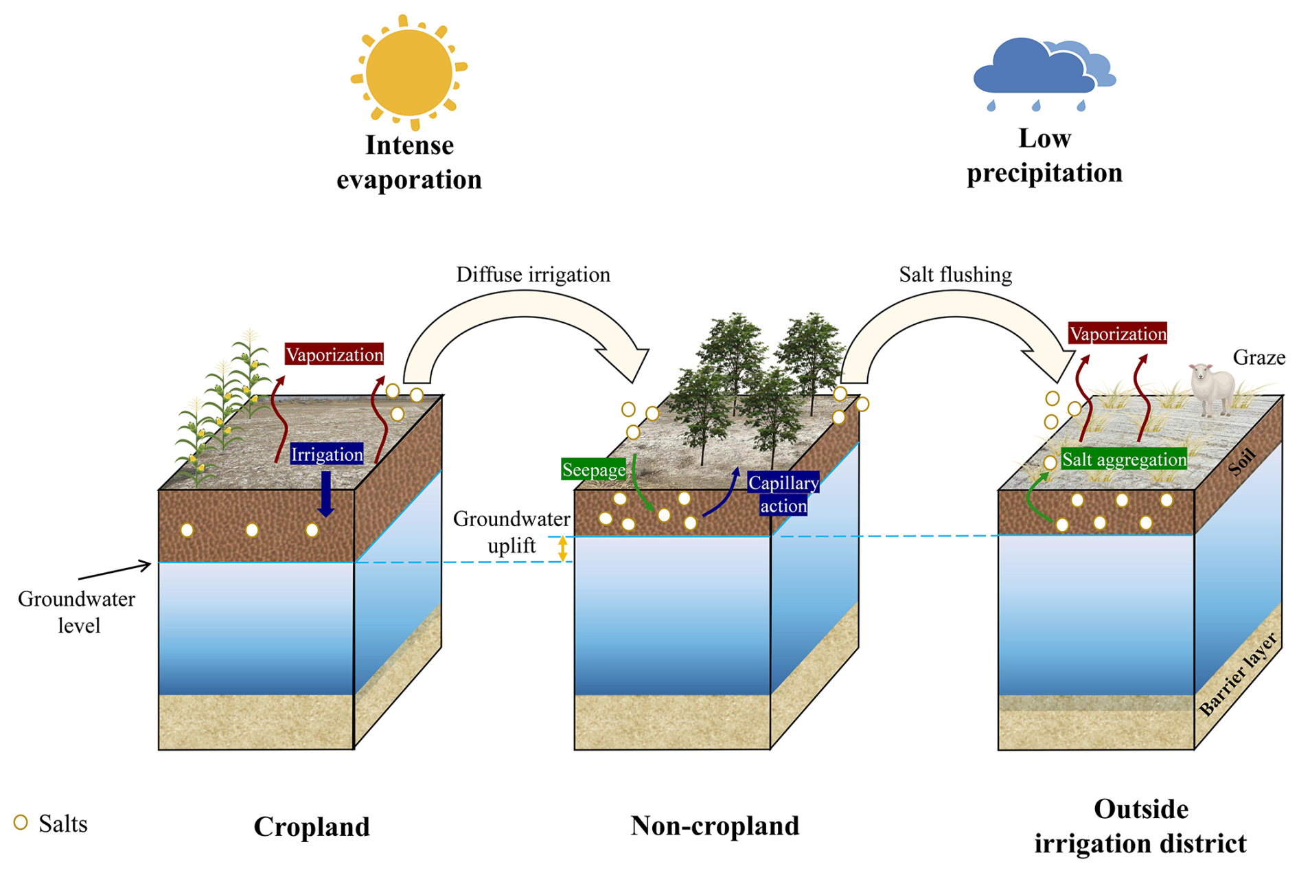
In the basin's irrigation area, irrigation modes significantly impact soil salinization in both agricultural and non-agricultural regions (Fig. 9). Irrigation increases soil moisture replenishment, triggering more complex mechanisms in the vegetation root zone. When irrigation water exceeds plant root absorption capacity and evaporation rates, excess water seeps into the groundwater system, causing groundwater level rise. During irrigation processes, soil moisture and salts are leached into soil layers and concentrate towards the surface through plant root water absorption (Raats, 1974; Gao et al., 2024). Soil salinization leads to vegetation degradation or affects vegetation diversity (Perri et al., 2020; Jiao et al., 2021). Lands outside the irrigation area also face salinization risks. Although leaching soil salts within the irrigation area can somewhat improve salinization conditions, the resulting high-salinity water can seep into areas outside the irrigation zone. As water evaporates, salts accumulate in the soil surface, exacerbating soil salinization problems (Singh, 2022). Additionally, due to the unique geographical environment of the Minqin oasis region, livestock farming is an important industry. However, excessive grazing leads to soil compaction, reducing soil porosity and decreasing soil permeability. Water struggles to penetrate deeply into the soil, further exacerbating the soil salinization.
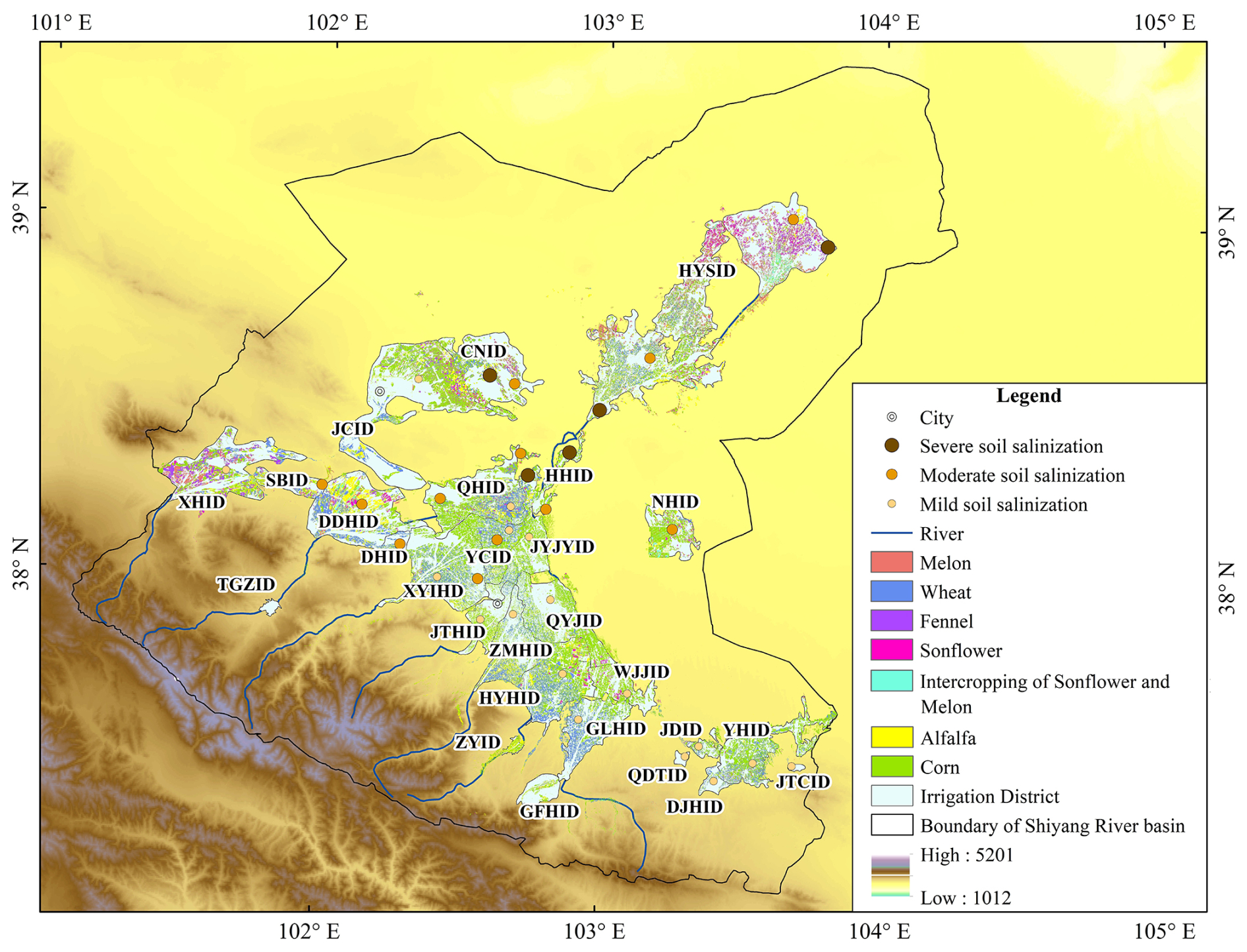
Figure 10Distribution of irrigation areas in the Shiyang River basin.
Surface water and groundwater irrigation are the primary irrigation methods in the Shiyang River basin, significantly impacting soil salinization in both agricultural and non-agricultural areas (Fig. 9). The Shiyang River basin comprises 27 irrigation districts (Fig. 10), with seriously salinized districts concentrated in the middle and lower reaches, while non-salinized districts are located in the upstream region. Severe soil salinization includes the Hongyashan Irrigation District (HYSID), Changning Irrigation District (CNID), and Huanhe Irrigation District (HHID). Moderate soil salinization includes the Dongdahe Irrigation District (DDHID), Nanhu Irrigation District (NHID), Donghe Irrigation District (DHID), Xiyinghe Irrigation District (XYHID), Siba Irrigation District (SBID), and Qinghe Irrigation District (QHID). Among these, the DDHID experienced particularly severe soil salinization, with a significant increase in salinized area during 2007–2012. Mild soil salinization includes the Gulanghe Irrigation District (GLHID), Wujiajing Irrigation District (WJJID), Huangyanghe Irrigation District (HYHID), Yinhuang Irrigation District (YHID), Qiduntai Irrigation District (QDTID), Jingdian Irrigation District (JDID), Dajinghe Irrigation District (DJHID), Qingyuanjing Irrigation District (QYJID), Zamuhe Irrigation District (ZMHID), Jintahe Irrigation District (JTHID), Jingtaichuan Irrigation District (JTCID), Jinyangjingyuan Irrigation District (JYJYID), Jinchuan Irrigation District (JCID), Yongchang Irrigation District (YCID), and Xihe Irrigation District (XHID). The GLHID and WJJID showed a continuous increase in salinized area from 2002 to 2017 but experienced a reduction from 2017 to 2022, while other districts saw minimal changes in salinization area. The Zhangyi Irrigation District (ZYID), Gufenghe Irrigation District (GFHID), and Tuiguangzhan Irrigation District (TGZID) have no salinization. Overall, irrigation is the main factor influencing the gradual increase in soil salinization from upstream to downstream regions in the Shiyang River basin, highlighting the profound impact of human agricultural activities on salinization in the basin.
4.3 Uncertainty in research
This study analyzed soil salinization in the Shiyang River basin using Landsat satellite data. However, due to the inherent uncertainties of satellite data, the results may have certain limitations. Although satellites can provide multispectral data, the spectral resolution is relatively low, and atmospheric correction issues may also affect data accuracy, posing challenges for identifying soil salinization (Vicente-Serrano et al., 2008; Vanonckelen et al., 2013). Landsat has a revisit cycle of 16 d, which can be further extended by climatic effects during certain seasons, significantly limiting seasonal monitoring of the region. Additionally, the selection and quantity of training data directly affect the accuracy of supervised classification. An accuracy assessment of the supervised classification results revealed classification accuracies of 89.40 %, 88.37 %, 89.80 %, 99.52 %, and 96.83 % for the years 2002, 2007, 2012, 2017, and 2022, respectively, with kappa coefficients of 0.82, 0.81, 0.82, 0.99, and 0.95. However, due to the limitations of sampling size and satellite data, the identification of mildly saline–alkaline land is slightly less effective compared to for other types of land, which requires further improvement in future work. Because soil salinization is influenced by multiple interacting factors such as climate and irrigation, single-satellite data alone struggle to fully capture the variation of all environmental components. Future research will expand data sources by integrating field measurements, meteorological records, and irrigation information to obtain more comprehensive or higher-resolution multi-source fusion data. Our systematic soil salinity monitoring for this basin began in 2019, which represents a limited time frame that prevents us from comprehensively validating remote sensing interpretation results using long-term soil physicochemical parameter data. Consequently, current accuracy assessments primarily rely on field-verified sample points collected between 2019 and 2024, which somewhat constrains our ability to verify the long-term dynamic processes of saline land changes. Nevertheless, these validation points still provide important ground truth references for remote sensing monitoring results. Moreover, the application of deep-learning models for image classification and feature extraction could deepen our understanding of the driving mechanisms behind soil salinization distribution, thereby improving the applicability of such findings in hydrology and soil management.
This study quantified soil salinization changes and their impacts on water cycle mechanisms in the Shiyang River basin of Northwest China's arid region from 2002 to 2022 using remote sensing data. The basin's salinization area showed, overall, minimal variation, but salinity gradually intensified from the southwest to the northeast. The salinity degree increased in the following ways: moderate salinization expanded in the central corridor plain area, while severe salinization increased in the northern hills and oasis–desert transition zone. Salinization was particularly severe around reservoirs, certain agricultural lands, and ecological water input areas, primarily caused by groundwater evaporation near reservoirs, agricultural irrigation evaporation, and downstream ecological water input evaporation. However, reservoir anti-seepage treatment measures can significantly reduce salinization problems arising from groundwater level rises around reservoirs. The leaching effect of irrigation water lowered salt levels in oasis irrigation districts, but salt concentrations continued to rise in the agricultural periphery. Inappropriate land management seriously affected basin soils, with extremely high risks of agricultural lands, grasslands, and wastelands being converted into saline lands. This research will provide more scientific basis for agricultural and water resource management in the basin.
The 30 m land use classification data for the Shiyang River basin used in this study are available in the public domain (https://doi.org/10.5281/zenodo.8176941, Yang and Huang, 2023, last access: 22 June 2025). Landsat series data were obtained from the Earth Explorer service (https://earthxplorer.usgs.gov, last access: June 22 2025).
GZ and GM conceived the idea of the study. YJ, DQ, and YW analyzed the data. RL, LC, and QW participated in the drawing of the figures. GM wrote the paper. SL, EH, JL, and WL checked and edited the language. All of the authors discussed the results and revised the paper.
The contact author has declared that none of the authors has any competing interests.
Publisher's note: Copernicus Publications remains neutral with regard to jurisdictional claims made in the text, published maps, institutional affiliations, or any other geographical representation in this paper. While Copernicus Publications makes every effort to include appropriate place names, the final responsibility lies with the authors.
This research was financially supported by the National Natural Science Foundation of China (grant nos. 42371040 and 41971036), the Key Natural Science Foundation of Gansu Province (grant no. 23JRRA698), the Key Research and Development Program of Gansu Province (grant no. 22YF7NA122), the Cultivation Program of Major key projects of Northwest Normal University (grant no. NWNU-LKZD-202302), and the Oasis Scientific Research achievements Breakthrough Action Plan Project of Northwest Normal University (grant no. NWNU-LZKX-202303).
This paper was edited by Hongkai Gao and reviewed by four anonymous referees.
Abbas, A., Khan, S., Hussain, N., Hanjra, M. A., and Akbar, S.: Characterizing soil salinity in irrigated agriculture using a remote sensing approach, Phys. Chem. Earth, 55–57, 43–52, https://doi.org/10.1016/j.pce.2010.12.004, 2013.
Aboelsoud, H. M., Habib, A., Engel, B., Hashem, A. A., Abou El-Hassan, W., Govind, A., Elnashar, A., Eid, M., and Kheir, A. M. S.: The combined impact of shallow groundwater and soil salinity on evapotranspiration using remote sensing in an agricultural alluvial setting, J. Hydrol. Reg. Stud., 47, 101372, https://doi.org/10.1016/j.ejrh.2023.101372, 2023.
Abu Hammad, A. and Tumeizi, A.: Land degradation: socioeconomic and environmental causes and consequences in the eastern Mediterranean, Land Degrad. Dev., 23, 216–226, https://doi.org/10.1002/ldr.1069, 2012.
Allbed, A. and Kumar, L.: Soil salinity mapping and monitoring in arid and semi-arid regions using remote sensing technology: a review, Advances in Remote Sensing, 2, 373–385, https://doi.org/10.4236/ars.2013.24040, 2013.
Beck, H. E., Zimmermann, N. E., McVicar, T. R., Vergopolan, A., Berg, A., and Wood, E. F.: Present and future Köppen-Geiger climate classification maps at 1-km resolution, Sci. Data, 5, 180214, https://doi.org/10.1038/sdata.2018.214, 2018.
Beck, H. E., McVicar, T. R., Vergopolan, N., Lutsk, N. J., Dufour, A., Zeng, Z., Jiang, X., van Dijk, I. J. M., and Miralles, D. G.: High-resolution (1 km) Köppen-Geiger maps for 1901–2099 based on constrained CMIP6 projections, Sci. Data, 10, 724, https://doi.org/10.1038/s41597-023-02549-6, 2023.
Bünemann, E. K., Bongiorno, G., Bai, Z., Creamer, R. E., De Deyn, G., de Goede, R., Fleskens, L., Geissen, V., Kuyper, T. W., Mäder, P., Pulleman, M., Sukkel, W., van Groenigen, J. W., and Brussaard, L.: Soil quality – A critical review, Soil Biol. Biochem., 120, 105–125, https://doi.org/10.1016/j.soilbio.2018.01.030, 2018.
Cañedo-Argüelles, M., Kefford, B. J., Piscart, C., Prat, N., Schäfer, R. B., and Schulz, C.-J.: Salinisation of rivers: An urgent ecological issue, Environ. Pollut., 173, 157–167, https://doi.org/10.1016/j.envpol.2012.10.011, 2013.
Chen, L., Zhang, R.-C., and Zeng, J.: Optimizing ecological and economic benefits in areas with complex land-use evolution based on spatial subdivisions, Landscape Urban Plan., 236, 104782, https://doi.org/10.1016/j.landurbplan.2023.104782, 2023.
Duan, K., Caldwell, P. V., Sun, G., McNulty, S. G., Qin, Y., Chen, X., and Liu, N.: Climate change challenges efficiency of inter-basin water transfers in alleviating water stress, Environ. Res. Lett., 17, 044050, https://doi.org/10.1088/1748-9326/ac5e68, 2022.
El Harti, A., Lhissou, R., Chokmani, K., Ouzemou, J., Hassouna, M., Bachaoui, E. M., and El Ghmari, A.: Spatiotemporal monitoring of soil salinization in irrigated Tadla Plain (Morocco) using satellite spectral indices, Int. J. Appl. Earth Obs. Geoinform., 50, 64–73, https://doi.org/10.1016/j.jag.2016.03.008, 2016.
Farifteh, J., Van der Meer, F., Atzberger, C., and Carranza, E. J. M.: Quantitative analysis of salt-affected soil reflectance spectra: A comparison of two adaptive methods (PLSR and ANN), Remote Sens. Environ., 110, 59–78, https://doi.org/10.1016/j.rse.2007.02.005, 2007.
Folberth, C., Skalský, R., Moltchanova, E., Balković, J., Azevedo, L. B., Obersteiner, M., and van der Velde, M.: Uncertainty in soil data can outweigh climate impact signals in global crop yield simulations, Nat. Commun., 7, 11872, https://doi.org/10.1038/ncomms11872, 2016.
Foster, S., Pulido-Bosch, A., Vallejos, Á., Molina, L., and MacDonald, A. M.: Impact of irrigated agriculture on groundwater-recharge salinity: a major sustainability concern in semi-arid regions, Hydrogeol. J., 26, 2781–2791, https://doi.org/10.1007/s10040-018-1830-2, 2018.
Gao, H., Hrachowitz, M., Wang-Erlandsson, L., Fenicia, F., Xi, Q., Xia, J., Shao, W., Sun, G., and Savenije, H. H. G.: Root zone in the Earth system, Hydrol. Earth Syst. Sci., 28, 4477–4499, https://doi.org/10.5194/hess-28-4477-2024, 2024.
Hassani, A., Azapagic, A., and Shokri, N.: Predicting long-term dynamics of soil salinity and sodicity on a global scale, P. Natl. Acad. Sci. USA, 117, 33017–33027, https://doi.org/10.1073/pnas.2013771117, 2020.
Hassani, A., Azapagic, A., and Shokri, N.: Global predictions of primary soil salinization under changing climate in the 21st century, Nat. Commun., 12, 6663, https://doi.org/10.1038/s41467-021-26907-3, 2021.
Hu, S., Li, Rong., and Gao, H.: Saline-alkali Soil Science and Comprehensive Utilization, Science Press, ISBN 978-7-030-80064-0, 2024.
IUSS Working Group WRB: World Reference Base for Soil Resources, International soil classification system for naming soils and creating legends for soil maps, 4th edn., International Union of Soil Sciences (IUSS), Vienna, Austria, ISBN 979-8-9862451-1-9, 2022.
Ivushkin, K., Bartholomeus, H., Bregt, A. K., Pulatov, A., Kempen, B., and de Sousa, L.: Global mapping of soil salinity change, Remote Sens. Environ., 231, 111260, https://doi.org/10.1016/j.rse.2019.111260, 2019.
Jägermeyr, J., Pastor, A., Biemans, H., and Gerten, D.: Reconciling irrigated food production with environmental flows for Sustainable Development Goals implementation, Nat. Commun., 8, 15900, https://doi.org/10.1038/ncomms15900, 2017.
Ji, X., Kang, E., Chen, R., Zhao, Z., Zhang, Z., and Jin, B.: The impact of the development of water resources on environment in arid inland river basins of Hexi region, Northwestern China, Environ. Geol., 50, 793–801, https://doi.org/10.1007/s00254-006-0251-z, 2006.
Jia, P., Zhang, J., Liang, Y., Zhang, S., Jia, K., and Zhao, X.: The inversion of arid-coastal cultivated soil salinity using explainable machine learning and Sentinel-2, Ecol. Indic., 166, 112364, https://doi.org/10.1016/j.ecolind.2024.112364, 2024.
Jiao, W., Wang, L., Smith, W. K., Chang, Q., and Wang, H.: Observed increasing water constraint on vegetation growth over the last three decades, Nat. Commun., 12, 3777, https://doi.org/10.1038/s41467-021-24016-9, 2021.
Karimzadeh, S., Hartman, S., Chiarelli, D. D., Rulli, M. C., and D'Odorico, P.: The tradeoff between water savings and salinization prevention in dryland irrigation, Adv. Water Resour., 183, 104604, https://doi.org/10.1016/j.advwatres.2023.104604, 2024.
Kaushal, S. S., Groffman, P. M., Likens, G. E., Belt, K. T., Stack, W. P., Kelly, V. R., Band, L. E., and Fisher, G. T.: Increased salinization of fresh water in the northeastern United States, P. Natl. Acad. Sci. USA, 102, 13517–13520, https://doi.org/10.1073/pnas.0506414102, 2005.
Khan, M. N., Rastoskuev, V. V., Sato, Y., and Shiozawa, S.: Assessment of hydrosaline land degradation by using a simple approach of remote sensing indicators, Agr. Water Manage., 77, 96–109, https://doi.org/10.1016/j.agwat.2004.09.038, 2005.
Kramer, I. and Mau, Y.: Soil degradation risks assessed by the SOTE model for salinity and sodicity, Water Resour. Res., 56, https://doi.org/10.1029/2020WR027456, 2020.
Lambin, E. F. and Meyfroidt, P.: Global land use change, economic globalization, and the looming land scarcity, P. Natl. Acad. Sci. USA, 108, 3465–3472, https://doi.org/10.1073/pnas.1100480108, 2011.
Lehmann, J., Bossio, D. A., Kögel-Knabner, I., and Rillig, M. C.: The concept and future prospects of soil health, Nat. Rev. Earth Environ., 1, 544–553, https://doi.org/10.1038/s43017-020-0080-8, 2020.
Li, J., Pu, L., Han, M., Zhu, M., Zhang, R., and Xiang, Y.: Soil salinization research in China: Advances and prospects, J. Geogr. Sci., 24, 943–960, https://doi.org/10.1007/s11442-014-1130-2, 2014.
Liang, F., Li, Z., and Zhang, L.: Practical Q&A and Case Analysis of Saline-alkali Land Improvement Technology, China Agriculture Press, ISBN 978-7-109-24618-8, 2018.
Lotfollahi, L., Delavar, M. A., Biswas, A., Fatehi, S., and Scholten, T.: Spectral prediction of soil salinity and alkalinity indicators using visible, near-, and mid-infrared spectroscopy, J. Environ. Manage., 345, 118854, https://doi.org/10.1016/j.jenvman.2023.118854, 2023.
Mao, W., Zhu, Y., Wu, J., Ye, M., and Yang, J.: Evaluation of effects of limited irrigation on regional-scale water movement and salt accumulation in arid agricultural areas, Agr. Water Manage., 262, 107398, https://doi.org/10.1016/j.agwat.2021.107398, 2022.
Metternicht, G. I. and Zinck, J. A.: Remote sensing of soil salinity: potentials and constraints, Remote Sens. Environ., 85, 1–20, https://doi.org/10.1016/S0034-4257(02)00188-8, 2003.
Minhas, P. S., Ramos, T. B., Ben-Gal, A., and Pereira, L. S.: Coping with salinity in irrigated agriculture: Crop evapotranspiration and water management issues, Agr. Water Manage., 227, 105832, https://doi.org/10.1016/j.agwat.2019.105832, 2020.
Perri, S., Suweis, S., Holmes, A., Marpu, P. R., Entekhabi, D., and Molini, A.: River basin salinization as a form of aridity, P. Natl. Acad. Sci. USA, 117, 17635–17642, https://doi.org/10.1073/pnas.2005925117, 2020.
Perri, S., Molini, A., Hedin, L. O., and Porporato, A.: Contrasting effects of aridity and seasonality on global salinization, Nat. Geosci., 15, 375–381, https://doi.org/10.1038/s41561-022-00931-4, 2022.
Qiu, D., Zhu, G., Bhat, M. A., Wang, L., Liu, Y., Sang, L., Lin, X., Zhang, W., and Sun, N.: Water use strategy of Nitraria tangutorum shrubs in ecological water delivery area of the lower inland river: Based on stable isotope data, J. Hydrol., 624, 129918, https://doi.org/10.1016/j.jhydrol.2023.129918, 2023.
Raats, P. A. C.: Steady flows of water and salt in uniform soil profiles with plant roots, Soil Sci. Soc. Am. J., 38, 717–722, https://doi.org/10.2136/sssaj1974.03615995003800050012x, 1974.
Renshu, R., Juneja, P., and Meenakshi, M.: Examining The Role of Soil in Promoting Sustainable Development and Achieving the UN Sustainable Development Goals (SDGs), Shodh Sari-An Int. Multidiscip. J., 3, 265–285, https://doi.org/10.59231/sari7734, 2024.
Reynolds, J. F., Maestre, F. T., Kemp, P. R., Stafford-Smith, D. M., and Lambin, E.: Natural and Human Dimensions of Land Degradation in Drylands: Causes and Consequences, in: Terrestrial Ecosystems in a Changing World, edited by: Canadell, J. G., Pataki, D. E., and Pitelka, L. F., Springer, Berlin, Heidelberg, 20–34, https://doi.org/10.1007/978-3-540-32730-1_20, 2007.
Sang, L., Zhu, G., Xu, Y., Sun, Z., Zhang, Z., and Tong, H.: Effects of agricultural large- and medium-sized reservoirs on hydrologic processes in the arid Shiyang River Basin, Northwest China, Water Resour. Res., 59, e2022WR033519, https://doi.org/10.1029/2022WR033519, 2023.
Seneviratne, S. I., Corti, T., Davin, E. L., Hirschi, M., Jaeger, E. B., Lehner, I., Orlowsky, B., and Teuling, A. J.: Investigating soil moisture–climate interactions in a changing climate: A review, Earth-Sci. Rev., 99, 125–161, https://doi.org/10.1016/j.earscirev.2010.02.004, 2010.
Sharma, B. R. and Minhas, P. S.: Strategies for managing saline/alkali waters for sustainable agricultural production in South Asia, Agr. Water Manage., 78, 136–151, https://doi.org/10.1016/j.agwat.2005.04.019, 2005.
Singh, A.: Soil salinity: A global threat to sustainable development, Soil Use Manag., 38, 39–67, https://doi.org/10.1111/sum.12772, 2022.
Smith, P., Cotrufo, M. F., Rumpel, C., Paustian, K., Kuikman, P. J., Elliott, J. A., McDowell, R., Griffiths, R. I., Asakawa, S., Bustamante, M., House, J. I., Sobocká, J., Harper, R., Pan, G., West, P. C., Gerber, J. S., Clark, J. M., Adhya, T., Scholes, R. J., and Scholes, M. C.: Biogeochemical cycles and biodiversity as key drivers of ecosystem services provided by soils, SOIL, 1, 665–685, https://doi.org/10.5194/soil-1-665-2015, 2015.
Thorslund, J., Bierkens, M. F. P., Oude Essink, G. H. P., Sutanudjaja, E. H., and van Vliet, M. T. H.: Common irrigation drivers of freshwater salinisation in river basins worldwide, Nat. Commun., 12, 4232, https://doi.org/10.1038/s41467-021-24281-8, 2021.
Tian, F., Zhang, Y., and Lu, S.: Spatial-temporal dynamics of cropland ecosystem water-use efficiency and the responses to agricultural water management in the Shiyang River Basin, northwestern China, Agr. Water Manage., 237, 106176, https://doi.org/10.1016/j.agwat.2020.106176, 2020.
Vanonckelen, S., Lhermitte, S., and Van Rompaey, A.: The effect of atmospheric and topographic correction methods on land cover classification accuracy, Int. J. Appl. Earth Obs. Geoinform., 24, 9–21, https://doi.org/10.1016/j.jag.2013.02.003, 2013.
Vicente-Serrano, S. M., Pérez-Cabello, F., and Lasanta, T.: Assessment of radiometric correction techniques in analyzing vegetation variability and change using time series of Landsat images, Remote Sens. Environ., 112, 3916–3934, https://doi.org/10.1016/j.rse.2008.06.011, 2008.
Wang, H. and Jia, G.: Satellite-based monitoring of decadal soil salinization and climate effects in a semi-arid region of China, Adv. Atmos. Sci., 29, 1089–1099, https://doi.org/10.1007/s00376-012-1150-8, 2012.
Wang, Y. and Li, Y.: Land exploitation resulting in soil salinization in a desert–oasis ecotone, CATENA, 100, 50–56, https://doi.org/10.1016/j.catena.2012.08.005, 2013.
Wichelns, D. and Qadir, M.: Achieving sustainable irrigation requires effective management of salts, soil salinity, and shallow groundwater, Agr. Water Manage., 157, 31–38, https://doi.org/10.1016/j.agwat.2014.08.016, 2015.
Wu, X., Xia, J., Zhan, C., Jia, R., Li, Y., Qiao, Y., and Zou, L.: Modeling soil salinization at the downstream of a lowland reservoir, Hydrol. Res., 50, 1202–1215, https://doi.org/10.2166/nh.2019.041, 2019.
Xiao, C., Ji, Q., Zhang, F., Li, Y., Fan, J., Hou, X., Yan, F., Liu, X., and Gong, K.: Effects of various soil water potential thresholds for drip irrigation on soil salinity, seed cotton yield and water productivity of cotton in northwest China, Agr. Water Manage., 279, 108172, https://doi.org/10.1016/j.agwat.2023.108172, 2023.
Yang, J. and Huang, X.: The 30 m annual land cover datasets and its dynamics in China from 1985 to 2022, Zenodo [data set], Earth Syst. Sci. Data, 13, 3907–3925, https://doi.org/10.5281/zenodo.8176941, 2023.
Yang, J., Zhao, J., Zhu, G., Wang, Y., Ma, X., Wang, J., Guo, H., and Zhang, Y.: Soil salinization in the oasis areas of downstream inland rivers – Case Study: Minqin oasis, Quatern. Int., 537, 69–78, https://doi.org/10.1016/j.quaint.2020.01.001, 2020.
Yang, R. and Xu, H.: Water diversion and agricultural production: Evidence from China, J. Integr. Agr., 22, 1244–1257, https://doi.org/10.1016/j.jia.2023.03.006, 2023.
Yin, X., Feng, Q., Zheng, X., Wu, X., Zhu, M., Sun, F., and Li, Y.: Assessing the impacts of irrigated agriculture on hydrological regimes in an oasis-desert system, J. Hydrol., 594, 125976, https://doi.org/10.1016/j.jhydrol.2021.125976, 2021.
Zhang, X. and Huang, B.: Prediction of soil salinity with soil-reflected spectra: A comparison of two regression methods, Sci. Rep., 9, 5067, https://doi.org/10.1038/s41598-019-41470-0, 2019.
Zhu, G., Liu, Y., Shi, P., Jia, W., Zhou, J., Liu, Y., Ma, X., Pan, H., Zhang, Y., Zhang, Z., Sun, Z., Yong, L., and Zhao, K.: Stable water isotope monitoring network of different water bodies in Shiyang River basin, a typical arid river in China, Earth Syst. Sci. Data, 14, 3773–3789, https://doi.org/10.5194/essd-14-3773-2022, 2022.
Zhuang, Q., Shao, Z., Huang, X., Zhang, Y., Wu, W., Feng, X., Lv, X., Ding, Q., Cai, B., and Altan, O.: Evolution of soil salinization under the background of landscape patterns in the irrigated northern slopes of Tianshan Mountains, Xinjiang, China, CATENA, 206, 105561, https://doi.org/10.1016/j.catena.2021.105561, 2021.
Zörb, C., Geilfus, C., and Dietz, K.: Salinity and crop yield, Plant Biol., 21, 31–38, https://doi.org/10.1111/plb.12884, 2018.