the Creative Commons Attribution 4.0 License.
the Creative Commons Attribution 4.0 License.
 | 04 Jan 2023
Contribution of cryosphere to runoff in the transition zone between the Tibetan Plateau and arid region based on environmental isotopes
Juan Gui
Zongxing Li
Qi Feng
Qiao Cui
Jian Xue
As the transition zone between the Tibetan Plateau and arid region, the Qilian Mountains are important ecological barriers and source regions of inland rivers in northwest China. In recent decades, drastic changes in the cryosphere have had a considerable impact on the formation process of water resources in the Qilian Mountains. In this study, 2164 environmental isotope samples were used to quantify the runoff components of 11 major rivers in the Qilian Mountains and investigate the influence of cryosphere changes on mountain runoff. The results show that the mountain runoff primarily originates in the cryosphere belt, which contributes approximately 82 %, 71 %, and 80 % to the Hexi inland water system, the upper stream of the Yellow River system, and the Qinghai inland river system, respectively. The maximum contribution ratio of glacier and snow meltwater to runoff occurred in May. The contribution of supra-permafrost water to runoff gradually increased from May and reached approximately 40 % in some rivers in October. Cryosphere degradation in the Qilian Mountains after the 1990s has caused a rapid increase in runoff, changes in the peak runoff time, and an increase in winter runoff. These changes in the hydrological processes bring opportunities and challenges to managing inland river water resources, and various adaptive measures to seek advantages and avoid disadvantages have been proposed. The findings from the environmental isotope analysis provide insights into understanding water resources and realizing the nexus of life, agriculture, industry, and ecological water use.
- Article
(12245 KB) - Full-text XML
- BibTeX
- EndNote


Characterizing the storage- and streamflow-release mechanisms of precipitation in watersheds provides important hydrological information of a specific region (Miller et al., 2021) Particularly, in the current context, global freshwater resources are under increasing stress due to climate change and growing populations (Florke et al., 2018). Mountains act as natural reservoirs of freshwater in the form of snow and glaciers and are therefore the principal components of the global water supply. Numerous studies have shown that runoff from glacier discharge provides a valuable resource to downstream populations for domestic, agricultural, and other allied activities (Kriegel et al., 2013). Shortages and low-use efficiencies of water resources have resulted in water-related issues in China, which will be further exacerbated by the continuous loss of glaciers and wetlands. Glacierized catchments in mountainous regions are generally headwater catchments, which are of great interest due to their complex runoff-generation processes and supply of water to downstream regions (Immerzeel et al., 2010). In various headwater catchments, seasonal water availability is strongly dependent on cryospheric processes, which becomes even more relevant in a changing climate (IPCC, 2013). In the last several decades, the temperature of the permafrost in the Qinghai–Tibet Plateau has significantly increased, and the region has experienced widespread degradation. Snow-covered areas have also been decreasing in the past 50 years (Yao et al., 2013), as a result, the runoff process has undergone significant changes in seasonal flow, flood peak discharge, and total runoff (Yang et al., 2000). Therefore, it is imperative to understand the source, processes, and mechanisms of runoff, particularly in seasonally arid mountainous areas, such as in western China, where snowmelt is vital for downstream human activities (Milly and Dunne, 2020), as well as managing and sustaining water resources in a changing environment. However, runoff generation processes are complex and difficult to quantify, particularly before an investigation is conducted (Uhlenbrook et al., 2002).
Environmental tracers are commonly used to investigate hydrological processes. Stable isotopes in water (2H and 18O) are important components of natural water bodies and powerful tools for investigating the water cycle and hydrological processes. Although their natural abundance is low, they are highly sensitive to changes in their environment and can indicate the source, migration, and transformation of water and are therefore ideal tracers for components of the water cycle (Gat et al., 1996; Bowen et al., 2019; Xianfang et al., 2007). The stable isotope ratios of hydrogen and oxygen in water samples can provide essential information about water dynamics within a given watershed (Rock and Mayer, 2007). For inland river basins with widely distributed glaciers and permafrost areas, stable isotope tracing is particularly useful, as direct, continuous field observations of hydrological processes are extremely difficult owing to the harsh environment (Cui and Li, 2015; Li et al., 2015). In the past few decades, isotopic tracers such as oxygen and deuterium isotopes have increasingly been utilized in conjunction with geochemical tracers and hydrometric measurements to separate flow pathways and provide more information regarding temporal and geographic sources of runoff in temperate, humid, and arid environments (Hooper and Shoemaker, 1986; Li et al., 2020a, b). McDonnel et al. (1991) found that stream water in New Zealand was partially supplied by subsurface flow in humid zones. Mortatti et al. (1997) reported that the average surface runoff and baseflow (pre-event) contributions were 30.3 % and 69.7 %, respectively, in the Amazon River. This method has been used to estimate the changes in glacier meltwater in many different regions, for example, the contribution of glacier and snowmelt water to runoff in spring was found to be as high as 82 % in a cold area in Colorado, USA (Liu et al., 2004). These studies found that glacier changes have a significant impact on the runoff of important rivers in cold regions. Climate warming has also significantly impacted the cold regions of western China where the annual average temperature has increased by 0.28 ∘C per 10 years during the period of 1961–2016 (Li et al., 2019), which has caused the glaciers in the study area to melt rapidly.
The Qilian Mountains are important ecological barriers and environmentally functional areas in northwest China (Wenxiong, 2012), which are not only the source region of the Hexi inland river system (HIRS), including the Shiyang, Heihe, and Shule River basins, from southeast to northwest, but also the source regions of the Qinghai inland river system (QIRS), including the Qinghai and Hala Lake basins and upper stream of the Yellow River (USYR) system . In the Qilian Mountains, the glacier area was 2017.81 km2 in 1956, 1761.3 km2 in 1990, and 1597.1 km2 in 2010 (Liu et al., 2003; Shengjie et al., 2011; Meiping et al., 2015). The permafrost area has continuously decreased in the Tibetan Plateau over the past 50 years (Weiming et al., 2012). Drastic changes in the cryosphere are bound to have a significant impact on the quantity and formation process of water resources in the inland rivers of the Qilian Mountains, which are fed by glacial meltwater.
Against the background of climate warming and the continuous retreat of the cryosphere, it is urgent to understand the runoff replenishment amount of the cryosphere and runoff formation process in the study region for decision-making purposes regarding the rational development and utilization of water resources in river basins. However, due to the lack of data and observation- and sampling-related challenges in cold regions, previous studies have only focused on the statistical analysis of runoff and its associated influencing factors; hence, there is a lack of in-depth knowledge of the mechanism of the temporal and spatial variations in runoff components from a microscopic point of view, while the quantification of the impacts of the cryosphere meltwater on runoff in the Qilian Mountains remains ambiguous. The Danghe, Changma, Taolai, Heihe, Xiying, Nanying, Zamu, Jinqiang, Datong, Huangshui, and Buha rivers were selected as the research objects in this study. The objectives of this study were as follows: (a) to understand the spatial and temporal differences of stable isotopes in various water bodies in the Qilian Mountains, (b) to quantify the runoff components of major rivers using δ18O and deuterium excess (d-excess) as a proxy in the Qilian Mountains, and (c) to determine the impact of cryosphere degradation on water resources in inland river basins. The results of this study provide insights into the sources of streamflow and stream water fractions and can provide a more effective understanding of the internal hydrological processes in a depopulated alpine zone under the impacts of climate change.

Figure 1Location of (a) study region (1. Danghe River, 2. Changma River, 3. Taolai River, 4. Heihe River, 5. Xiying River, 6. Nanying River, 7. Zamu River, 8. Datong River, 9. Huangshui River, 10. Jinqiang River, 11. Buha River) and (b) sampling site.
2.1 Study region
The Qilian Mountains are located on the northeastern edge of the Tibetan Plateau and consist of a series of NW trending parallel mountains and valleys with latitudes ranging from 36–43∘ N and longitudes of 92–107∘ E (Fig. 1). The average annual temperature in the Qilian Mountains is between −5.25 to10.75 ∘C. The average annual precipitation in the Qilian Mountain ranges from 34.23 to 493.97 mm and increases gradually from west to east (Yuemin et al., 2019). Rivers are widely distributed with radial drainage characteristics in the Qilian Mountains, and the Leng Long Ling range divides all rivers into internal flow and outflow systems. The outflow rivers mainly include the Huangshui and Datong rivers, which are located in the USYR. The inner flow is divided into three parts: the Qaidam, Qinghai Lake, and Hexi Corridor basins. Among these rivers, the Danghe, Taolai, Heihe, Xiying, Nanying, and Zamu rivers belong to the HIRS, and the Buha River belongs to the QIRS. The southern rivers of the Qilian Mountains primarily flow into the Qaidam Basin, while the northern rivers flow into the Hexi Corridor (Deng, 2013). Generally, the annual distribution of surface runoff is consistent with the precipitation process and high-temperature season in the Qilian Mountains. Runoff and precipitation are concentrated in the warm season in the area, and it is mainly recharged by ice and snow meltwater and groundwater in spring and precipitation in summer. The annual variation in runoff shows an evident periodic trend as detailed by Wang (2006). The rivers in the Qilian Mountains are mainly fed by glacial meltwater. Water originates in the cryosphere belt, which contains glaciers, snow, and permafrost (Zongxing et al., 2019). According to the second glacier inventory of China and permafrost dataset of the Qinghai–Tibet Plateau, there are 2859 glaciers in the Qilian Mountains with a total area of 1597 km2; the total area of glacier reserve and permafrost are 84.48×10⁸ m3 (Meiping et al., 2015) and 9.39×10⁴ km2 (Zhou et al., 2000), respectively. The inter-annual variation in runoff is small, but there are significant seasonal and daily variations. River runoff in the western and middle sections of the Qilian Mountains has increased significantly since 1980, whereas the eastern section has shown a slight decreasing trend (Zhang and Zhao, 2018).
2.2 Sample collection and analysis
In addition to river water samples, precipitation, glacier and snow meltwater, supra-permafrost water, groundwater, and outlet river water were continuously collected in the Qilian Mountains at the sampling sites shown in Fig. 1. The details of the samples are as follows:
-
River water (338). A sampling network of 11 river water sampling stations was established in the Qilian Mountains. The Danghe, Xiying, Taolai, Heihe, Nanying, Zamu, and Changma rivers belong to the HIRS; three samples were collected every month at the river outlets, and a total of 252 samples were collected from September 2018 to August 2019. The Datong, Huangshui, and Jinqiang rivers belong to the USYR; water from the river outlets was collected twice a month, and a total of 62 samples were collected from July 2017 to July 2018 (no samples were collected from the Jinqiang River in January, February, March, and December). Similarly, from August 2020 to August 2021, a total of 24 river water samples were collected from the Buha River in the QIRS.
-
Precipitation (1310). An observation network of precipitation stable isotope including 19 sampling stations in the Qilian Mountains was established (Fig. 1), and 1310 groups of precipitation samples were collected during 2012–2018 in Mengyuan, Huangyuan, Gulang, Qilian, Yeniugou, Tuole, Minle, Gangcha, Tianjun, Jiayuguan, Jiutiaoling, Xidahe, Changma, Daiqian, Anyuan, Suli, Ebao, Hulugou, and Binggou. All the precipitation events were collected according to the definition of a precipitation event stipulated by meteorological observation, that is, all the precipitation from 20:00 LT of the same day to 20:00 LT of the next day was defined as a precipitation event, and a sample was collected. A total of 1310 groups of precipitation samples has been collected during the period of 2012–2018. For more information, please refer to Juan et al. (2020).
-
Glacier and snow meltwater (96). The hydrochemical characteristics of glacier and snow meltwater in the cryosphere were analyzed. Glacier samples were collected every half a month from May to October. The snow covering the glaciers begins to melt in March and April as the weather warms, and by May, the snow is almost entirely melted. By June, the snow melts and flows into the channel as glacial meltwater. Essentially, snow cover at the end of the glacier has little effect on runoff segmentation.
The samples were taken at 14:00 LT every day, and the sampling location was in the hydrological section at the end of the glacier. During the sampling period, a total of 84 glacier meltwater samples were collected from the end of the Bayi, Shiyi, and source glaciers of the Taolai, Shule, Danghe, Shiyang, and Datong rivers. Twelve snow meltwater samples were also collected in the Buha and Huangshui rivers.
-
Supra-permafrost water (108). Supra-permafrost water, the most widely distributed type of groundwater, is mainly stored in the permafrost active layer. To determine the hydrochemical characteristics of supra-permafrost water in the study area, water samples were collected by comprehensive sampling from May to October in 2016 and 2018; sampling was performed manually. A 2 m deep profile of the permafrost active layer was dug at each sampling point. The water samples were then immediately filtered through a 0.45 µm Millipore filtration membrane and poured into clean polyethylene bottles. During this period, a total of 108 samples were collected from the Danghe, Changma, Heihe, Taolai, Shiyang, Datong, and Buha rivers.
-
Groundwater (312). A total of 240 samples were collected weekly from five wells in the Danghe, Changma, Taolai, Heihe, and Shiyang rivers of the HIRS within 1 hydrological year. Similarly, another 48 samples were collected twice a month from the Datong and Huangshui rivers in the USYR. Lastly, 24 samples were collected from the Buha River in the QIRS.
-
Meteorological and hydrological data. Meteorological and hydrological data for the Dang, Changma, Taolai, Heihe, Xiying, Nanying, Zamu, Datong, and Jinqiang rivers were obtained from the Hydrology and Water Resources Bureau of Gansu Province (HWRBGS). Runoff data for the Huangshui River were obtained from Tiaofeng et al. (2014), and Buha River runoff data were obtained from Liu et al. (2020). The details are provided in Table 1.
Table 1Hydrological data of various basins in the Qilian Mountains.

2.3 Methods
2.3.1 Sample testing
Water sample analyses were carried out in the Key Laboratory of Ecohydrology of Inland River Basins, Chinese Academy of Sciences, to determine the presence of hydrogen and oxygen stable isotopes. For the analysis of the stable isotopes of soil water, water was extracted from the soil using a cryogenic freezing vacuum extraction system (LI-2000, Beijing Liga United Technology Co. Ltd., China), which can achieve complete extraction with high precision. The stable isotopes in the water samples were measured using a liquid water stable isotope analyzer (Model DLT-100, Los Gatos Research, Inc., Mountain View, CA, USA). The accuracies of and were 0.2 ‰ and 0.5 ‰, respectively, which conform to the rule of valid digits for stable isotope analysis. The results were calibrated using the Vienna Standard Mean Ocean Water (VSMOW) and laboratory working standards. The final results were expressed in the form of micro-differences relative to VSMOW:
where RSample is the precipitation sample, and RV-Smow is the ratio of the oxygen or hydrogen stable isotope in VSMOW.
The d-excess can be defined as follows:
The value of d-excess is equivalent to the intercept when the slope of local meteoric water is eight, which represents the imbalance degree of the evaporation process.
2.3.2 End-member mixing analysis
Hooper (2003) introduced the end-member mixing analysis (EMMA) using chemical and isotopic compositions in waters. The techniques involve graphical analyses, in which chemical and isotopic parameters are used to represent the designated end members. Tracer concentrations are constant in space and time. Essentially, the change in the composition of the water can be attributed to the intersections it makes during its passage through each landscape zone. Tracers can be used to determine both sources and flow paths. The EMMA tracer approach is a conventional method for analyzing potential water sources contributing to streamflow (Zongxing et al., 2014, 2016a). In this study, a three end-member mass-balance mixing model was employed to calculate the contribution of three water sources in stream water according to Eq. (3a and b) below:
where X and Y represent the concentrations of two types of different tracers. In this study, the concentrations of δ18O and deuterium excess were chosen for comparison. Subscripts 1, 2, and 3 represent the water from the respective contributions of source waters 1, 2, and 3 (end members) to stream water; F denotes the fraction of each end-member; and the solutions for F1, F2, and F3 in regard to tracer concentrations in Eq. (3) can be given as
This method has been used in previous studies (Zongxing et al., 2014; Li et al., 2015) to evaluate the contribution of possible sources to the river water.
2.3.3 Uncertainty in hydrograph separation
The uncertainty of tracer-based hydrograph separations can be calculated using the error propagation technique (Genereux, 1998; Klaus and McDonnell, 2013); this approach considers errors of all separation equation variables. Assuming that the contribution of a specific streamflow component to streamflow is a function of several variables c1, c2, …, cn, and the uncertainty in each variable is independent of the uncertainty in the others, the uncertainty in the target variable (e.g., the contribution of a specific streamflow component) is estimated using the following equation (Uhlenbrook et al., 2002):
where W represents the uncertainty in the variable specified in the subscript, and fx is the contribution of a specific streamflow component, x, to streamflow. The software package MATLAB was used to apply Eq. (3) to the different hydrograph separations in this study.
3.1 Characteristics of stable isotopes in different waters
3.1.1 Precipitation
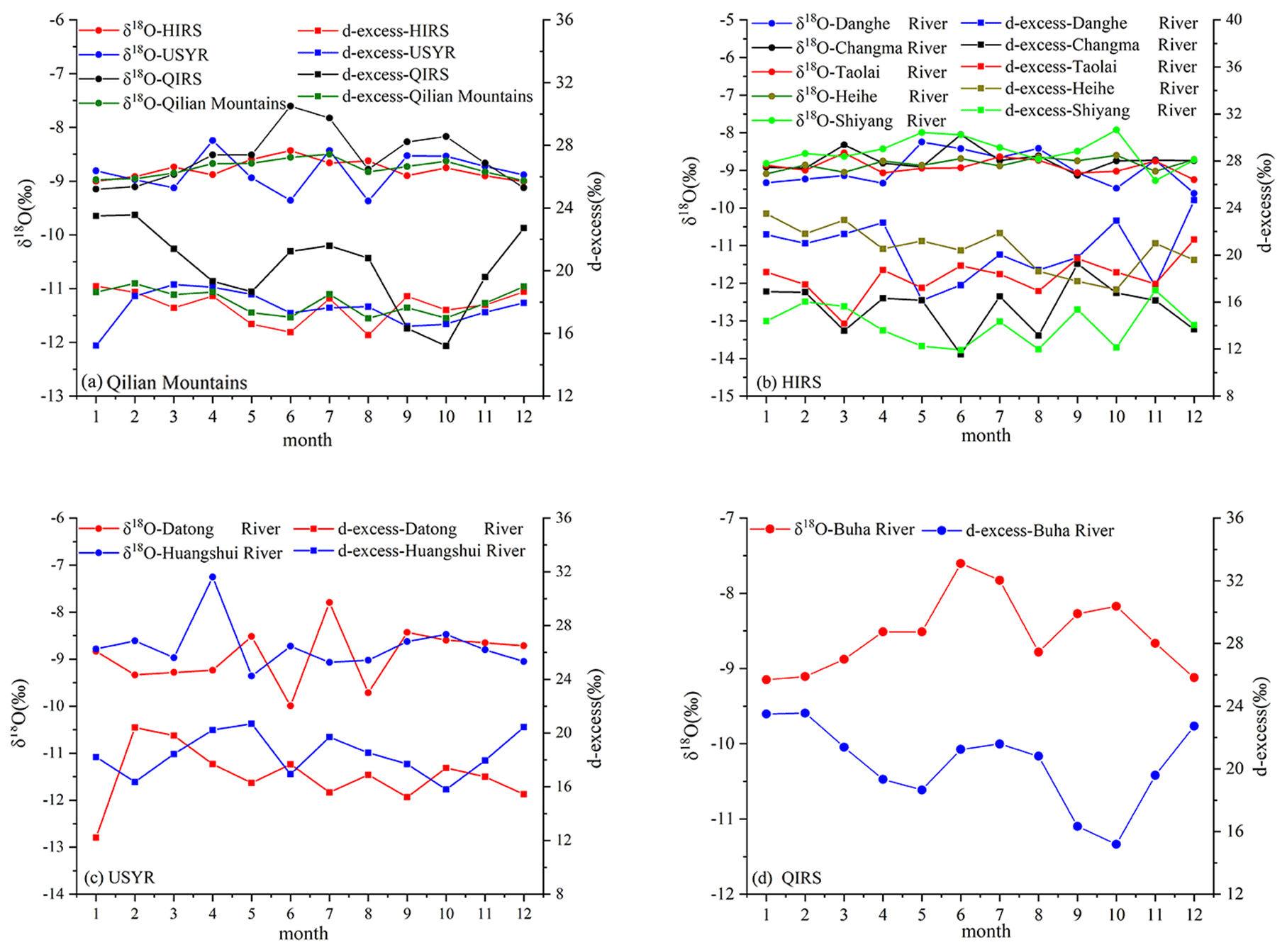
The δ18O in the precipitation was characterized by pronounced seasonal variations, with maximum values in summer and minimum values in winter. The monthly average values varied from −21.62 ‰ to −5.15 ‰, with an annual average of −12.11 ‰. From January to December, δ18O showed an initial increasing trend, after which it decreased, with the maximum value occurring in June. Owing to the combined influence of the water vapor source, temperature, precipitation, and other factors, the stable isotopes of the precipitation fluctuated greatly during the year (Fig. 2a).
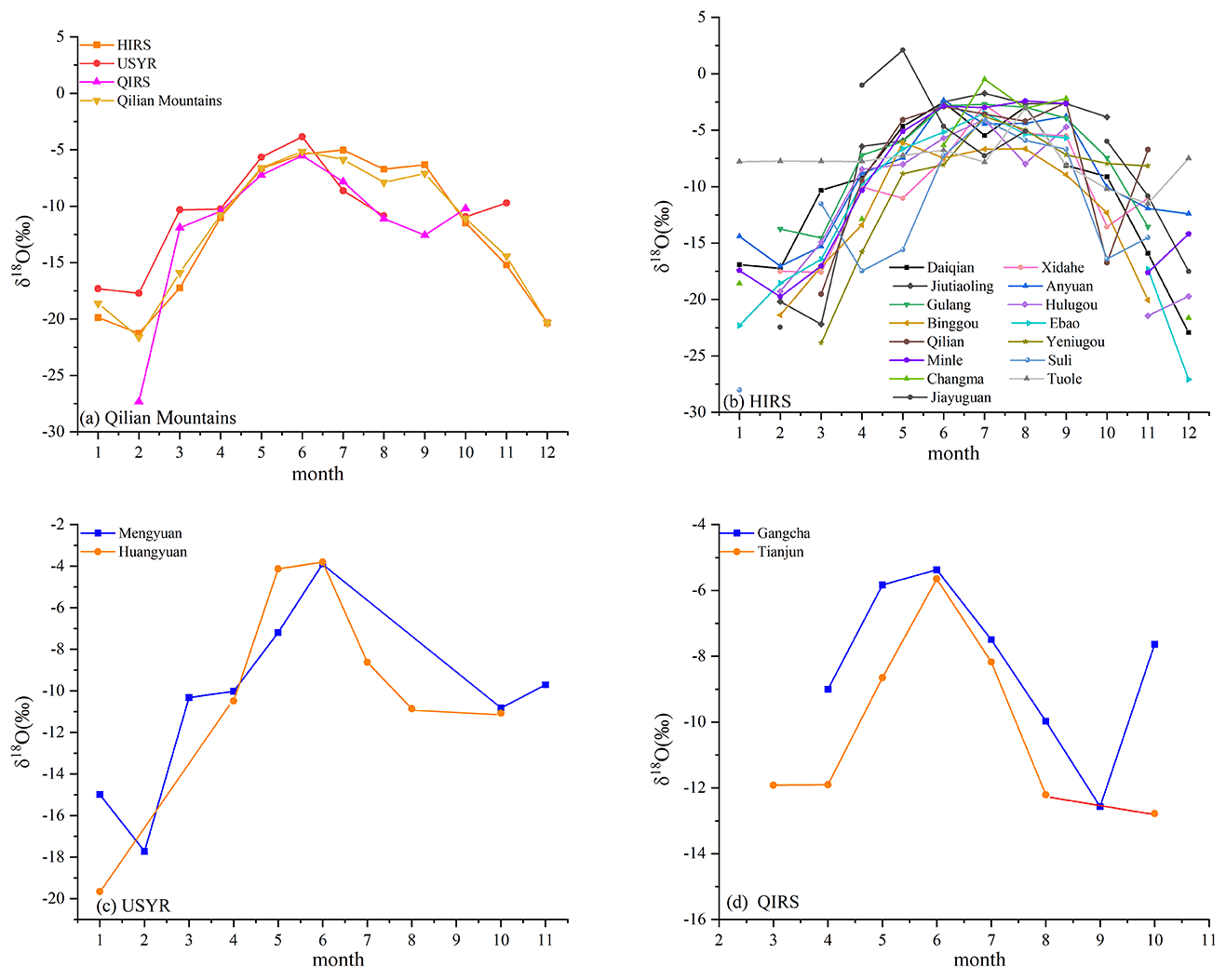
The HIRS is located on the northern slope of the Qilian Mountains, and the monthly average δ18O in the precipitation ranged from −21.26 ‰ to −5.03 ‰, with an annual average value of −12.21 ‰ (Fig. 2b). In the USYR and QIRS, located on the southern slope, the range of monthly average δ18O values were −17.72 ‰ to −3.85 ‰ and −27.32 ‰ to −5.51 ‰, respectively, with annual average values of −10.53 ‰ and −11.57 ‰, respectively (Fig. 2). Compared with the HIRS and QIRS, the average value of δ18O in the USYR was more positive. Different water vapor sources and climatic and topographic conditions resulted in evident spatial and temporal differences in stable isotopes in the precipitation in the study area.
3.1.2 Glacier and snow meltwater
Glacier and snow meltwater were collected from seven basins in the study area from May to October. As shown in Fig. 3, the mean δ18O in glacier and snow meltwater of the Qilian Mountains was −9.61 ‰, which is significantly lower than the corresponding river water. The seasonal fluctuation of glacier and snow meltwater was very low; although there were differences among several river systems, they were not significant. During the sampling period, the δ18O in glacier and snow meltwater in the HIRS varied from −13.07 ‰ to −7.97 ‰, with an average value of −9.69 ‰. The δ18O values of the glacier and snow meltwater in the Danghe River, Changma River, Shiyi Glacier, Bayi Glacier, Taolai River, and Shiyang River were −10.64 ‰, −9.31 ‰, −9.86 ‰, −9.77 ‰, −9.29 ‰, and −9.25 ‰, respectively. The mean δ18O values of glacier and snow meltwater increased from west to east. In the USYR, the δ18O in glacier and snow meltwater in the Datong River ranged from −10.24 ‰ to −8.06 ‰, with a mean value of −9.54 ‰. In general, from May to October, fluctuations in δ18O were low, and the overall trend first increased and then decreased, with the maximum value appearing in August and minimum value in May. In the QIRS, the δ18O in glacier and snow meltwater in the Buha River ranged from −11.69 ‰ to −8.26 ‰, with a mean value of −9.24 ‰. These δ18O values in the QIRS were higher than those in the HIRS and USYR system and fluctuated greatly during the study period.
Figure 3Temporal variation of stable isotopes in glacier and snow meltwater in the Qilian Mountains.
The δ18O values in glacier and snow meltwater were relatively stable during the sampling period and did not show any notable temporal variations. The maximum δ18O values in the HIRS, USYR system, and QIRS occurred in May, August, and July, while the minimum values were in June, May, and August. The time that the maximum and minimum values of δ18O occurred in the three river systems was not consistent, which may be attributed to the start time of glacier and snow melting and storage. The d-excess of glacier and snow meltwater also showed no evident seasonal characteristics during the sampling period. The d-excess in the HIRS, USYR system, and QIRS ranged from 19.33 ‰ to 22.06 ‰, 14.17 ‰ to 22.90 ‰, and 11.38 ‰ to 11.57 ‰, respectively, with mean values of 21.53 ‰, 17.42 ‰, and 11.47 ‰, respectively.
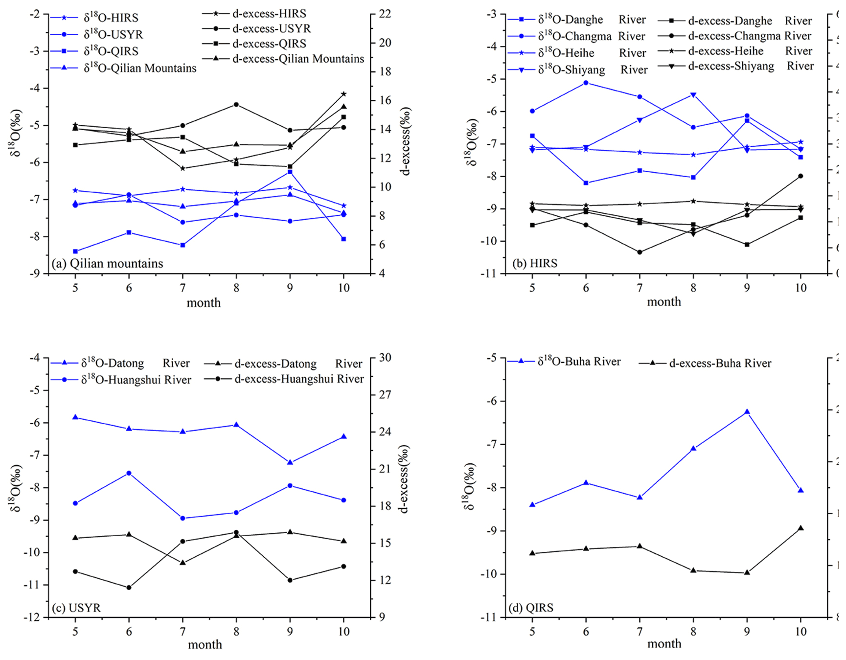
Figure 4Temporal variation of stable isotopes in supra-permafrost water in the Qilian Mountains.
3.1.3 Supra-permafrost water
Supra-permafrost water is groundwater that exists mainly in the permafrost active layer, which forms an important part of the runoff in cold regions (Zongxing et al., 2016a, b). The δ18O value in the supra-permafrost water was significantly higher than those of glacier and snow meltwater (Fig. 4); this was noted, because during the study period, the supra-permafrost water was subjected to higher temperatures, which resulted in intense evaporation. In the HIRS, the mean δ18O values in the supra-permafrost water ranged from −7.16 ‰ to −6.49 ‰, with an average of −6.69 ‰. The δ18O in the supra-permafrost water in the Heihe River was the most stable, with almost no fluctuations from May to October. The Danghe River showed slight fluctuations, with the maximum value occurring in September. In the Shiyang River basin, δ18O values were negative from May to June, positive from July to August, and negative from September to October, whereas in the Changma River, they were positive, with a maximum value of −5.12 ‰ in June and minimum of −7.15 ‰ in October. In the USYR system, the δ18O in the supra-permafrost water ranged from −7.61 ‰ to −6.87 ‰, with an average value of −7.34 ‰. The values in the Datong and Huangshui rivers of the USYR system were significantly different; the values of the Datong River were relatively positive, with an average value of −6.34 ‰, while those of the Huangshui River were relatively negative, with an average value of −8.34 ‰. In the Buha River of the QIRS, δ18O values were relatively stable, and the weak temporal variation showed peaks in June and September. In conclusion, the δ18O in the supra-permafrost water of the three river systems was generally positive and did not show notable temporal variations. This phenomenon can be explained as follows: firstly, supra-permafrost water is mainly stored in the active layer of the permafrost, and under strong evaporation (noted during the study period), the stable isotope concentration becomes unbalanced through the influence of dynamic fractionation. Secondly, the supra-permafrost water is then replenished by a mixture of precipitation and glacier and snow meltwater, which results in random fluctuations in the stable isotope concentrations. The range of the d-excess values for the supra-permafrost water for the corresponding river systems were 10.03 ‰–17.69 ‰, 13.56 ‰–15.73 ‰, and 11.43 ‰–14.87 ‰, respectively, with mean values of 13.36 ‰, 14.29 ‰, and 12.93 ‰, respectively (Fig. 4).
3.1.4 River water
As shown in Fig. 5, the δ18O in the river water in all basins in the study area was relatively stable and had significant seasonal variation characteristics, which differed from that of precipitation. The δ18O values in the different river systems in the Qilian Mountains were relatively stable and did not show evident seasonal variations, although there were some differences. The range of δ18O values were −8.75 ‰ to −8.27 ‰, −8.97 ‰ to −8.53 ‰, −8.15 ‰ to −7.26 ‰, and −9.47 ‰ to −7.96 ‰ for the Qilian Mountains, HIRS, USYR system, and QIRS, respectively, with corresponding mean values of −8.49 ‰, −8.72 ‰, −7.79 ‰, and −8.49 ‰. Although the δ18O value in rivers was relatively stable, there were slight variations from the annual mean value among the different river systems: USYR > QIRS > HIRS (Fig. 5a).
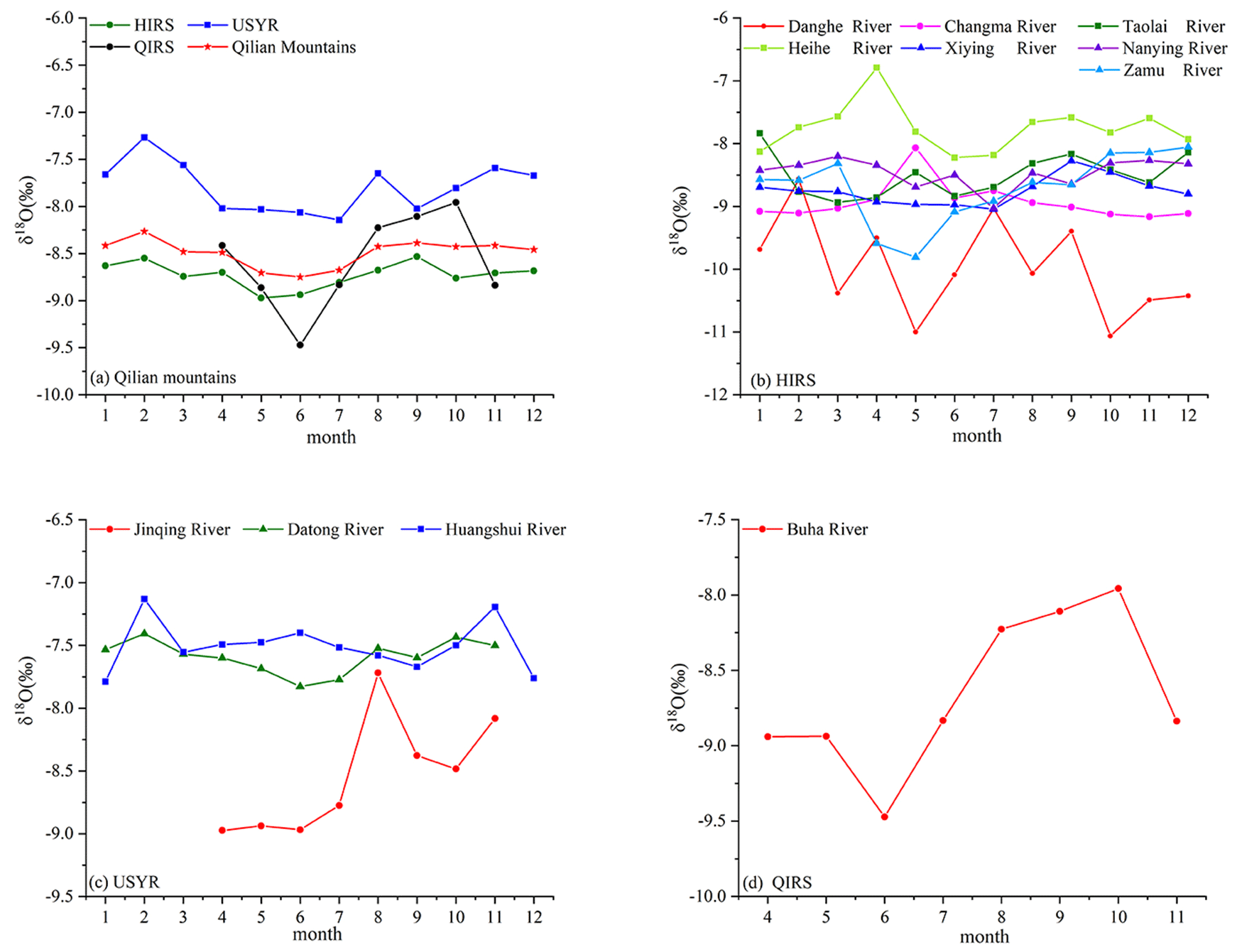
The maximum monthly mean values of δ18O in the HIRS, USYR, and QIRS were in September, February, and October, respectively, while the minimum monthly mean values were in May, July, and June, respectively. Owing to the significant distance from west to east in the HIRS, the δ18O values in the different rivers varied greatly; for example, in the Danghe River, in May and October, there was a higher depletion of δ18O (−11 ‰), while in February, it was more enriched (−9 ‰). The δ18O in the Shule River water in the western segment fluctuated greatly compared with that of the three rivers in the Shiyang River basin in the eastern segment. The Heihe River basin in the middle reaches had the highest average value of δ18O, followed by the Shiyang River basin in the eastern part, while that of the Shule River basin in the western part was significantly negative, with an average value of −9.97 ‰. The δ18O value in the river water of the Heihe River, located in the middle of the Qilian Mountains, was positive, with an annual average of −7.75 ‰ and −6.79 ‰ in April.
In the USYR system, except in the Jinqiang River, the river water δ18O values of the Huangshui and Datong rivers were relatively positive, with mean values of −7.76 ‰ and −7.58 ‰, respectively. The δ18O values of the river water in the Jinqiang River were relatively negative, with large fluctuations. In the QIRS, because of the large extent of uninhabited areas, sampling was conducted only in the Buha River, in which the δ18O values ranged from −9.47 ‰ to −7.96 ‰, with a mean of −8.59 ‰. In terms of its weak seasonal variation, the maximum δ18O occurred in October, and the minimum occurred in June.
The mean d-excess values in the Qilian Mountains, HIRS, USYR system, and QIRS were 13.63 ‰, 13.78 ‰, 13.56 ‰, and 20.20 ‰, respectively. According to the monthly mean values, the following was noted: USYR < HIRS < QIRS. In the HIRS, the d-excess value ranged from 8.52 ‰ to 16.15 ‰, except in the Dang River, where the annual variations in the other rivers were low. In the USYR, the d-excess value in the Jinqiang River was more positive than those of the Datong and Huangshui rivers (Fig. 6).

The differences in the stable isotopes in river water reflect the differences in the recharge sources and recharge processes in different river systems. If river water is only supplied by precipitation, its stable isotope composition should be closer to the stable isotope variation in precipitation. However, in this study, there was a significant difference between δ18O in the river water and precipitation, which indicates that the potential recharge source of these three river systems is not only precipitation.
3.1.5 Groundwater
Variations in the stable isotopes in groundwater were highly consistent with those of river water, the annual fluctuation was low, and there were no evident time variations. The δ18O in the groundwater in the Qilian Mountains ranged from −8.99 ‰ to −8.50 ‰, with a mean value of −8.76 ‰. In the HIRS, USYR system, and QIRS, the δ18O variation ranged from −9.01 to −8.43 ‰, −9.37 ‰ to −8.43 ‰, and −9.12 ‰ to −7.60 ‰, respectively, with corresponding mean values of −8.78 ‰, −8.83 ‰, and −8.55 ‰ (Fig. 7). The temporal variations in the δ18O values in river water and groundwater in the study area were highly consistent, which confirms that precipitation and supra-permafrost water may be transformed into groundwater runoff and then recharge. The δ18O concentration in the groundwater was more negative than that of the river water, which indicates that the evaporation effect of groundwater was relatively weak compared with that of river water. The mutual transformation relationship and frequent exchange processes between groundwater and river water were confirmed. In alpine desert zones, sparse vegetation, large soil particles, and high permeability are conducive to the infiltration of precipitation, snow, and ice meltwater, which can be converted into groundwater, thus replenishing runoff.
3.2 Relationships of stable isotopes between river water and various water sources
The isotopic relationship between river water and various water sources is shown in Fig. 8. The local meteoric water line (LMWL) of the Qilian Mountains was (R2=0.96), and the δ18O concentrations was clearly higher in summer and autumn but lower in winter and spring (Juan et al., 2020). For glacier and snow meltwater, the stable isotope was distributed in the center of the LMWL, while that of the supra-permafrost water was mainly distributed below the LMWL. The stable isotopic compositions of the river water were close to the LMWL, and between those of precipitation, glacier and snow meltwater, and supra-permafrost water, indicating that the river water was fed by all these sources of water. At the same time, the distribution of river water and groundwater showed a hydraulic connection. The local evaporation lines (LEL) of the Qilian Mountains, HIRS, USYR system, and QIRS were (R2=0.55, P<0.01), (R2=0.72, P<0.01), (R2=0.79, P<0.01), and (R2=0.58, P<0.01), respectively. The corresponding δ18O and δD values at the intersection of the LEL and LMWL were −8.19 ‰, −50.84 ‰; −8.54 ‰, −53.68 ‰; −8.21 ‰, −51.04 ‰; and −7.08 ‰, −42.01 ‰for the Qilian Mountains, HIRS, USYR, and QIRS, respectively, which were very similar to the corresponding mean values of δ18O and δD in groundwater (−8.76 ‰, −52.10 ‰; −8.78 ‰, −52.54 ‰; −8.83 ‰, −53.02 ‰; and −8.55 ‰, −48.07 ‰). This indicates that various types of water in the study area are converted into groundwater and then resupplied by river water.
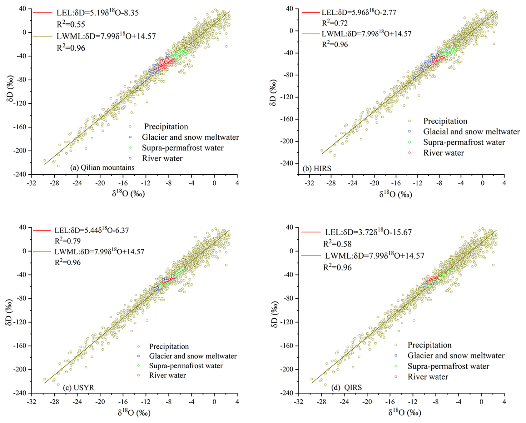
Figure 8Relationships of δ18O and δD between river water and various water types in (a) the Qilian mountains, (b) HIRS, (c) USYR, and (d) QIRS.
3.3 Components of outlet runoff
EMMA was used to determine the contribution ratio of the different water sources to runoff. The results of the above analysis show that there were significant spatiotemporal variations in d-excess and δ18O concentrations in the river and its supplementary components; therefore, δ18O and d-excess were selected as tracers for analysis, because this combination provides a reasonable separation of sources. In the three river systems of the Qilian Mountains and the Jinqiang and Huangshui rivers in the QIRS, there were no glaciers in the upper reaches; therefore, the binary segmentation model was adopted to calculate the supply source (Fig. 9h and j). For the remaining rivers, precipitation, supra-permafrost water, and glacier and snow meltwater were taken as three end-members, and the recharge sources were then calculated (Fig. 9). The results show that the precipitation was the main recharge source of seven rivers in the HIRS (Fig. 9a–g), and its contribution ratios to the Danghe, Changma, Taolai, Heihe, Xiying, Nanying, and Zamu rivers were 65 %, 51 %, 69 %, 59 %, 75 %, 80 %, and 79 %, respectively. More than half of the runoff in the HIRS was converted from precipitation; the contribution ratio increased from west to east and was as high as 80 % in the Nanying and Zamu rivers in the eastern part of the Qilian Mountains. This is consistent with the spatial distribution characteristics of higher precipitation in the east and lower precipitation in the west. In addition to precipitation, supra-permafrost water was an important recharge source for the HIRS. The contribution of supra-permafrost water to the Danghe, Changma, Taolai, Heihe, Xiying, Nanying, and Zamu rivers was approximately 21 %, 33 %, 20 %, 33 %, 19 %, 15 %, and 16 %, respectively, as the third end-member; the corresponding glacier and snow meltwater contributed approximately 14 %, 16 %, 11 %, 8 %, 6 %, 5 %, and 5 %, respectively, to runoff. Contrary to the spatial distribution trend of the precipitation contribution, the contribution ratio of glacier and snow meltwater showed a decreasing trend from west to east. This was mainly related to the storage and distribution of glaciers in the Qilian Mountains, in terms of glacier area and ice storage: Shule River basin >Heihe River basin >Shiyang River basin (Meiping et al., 2015).
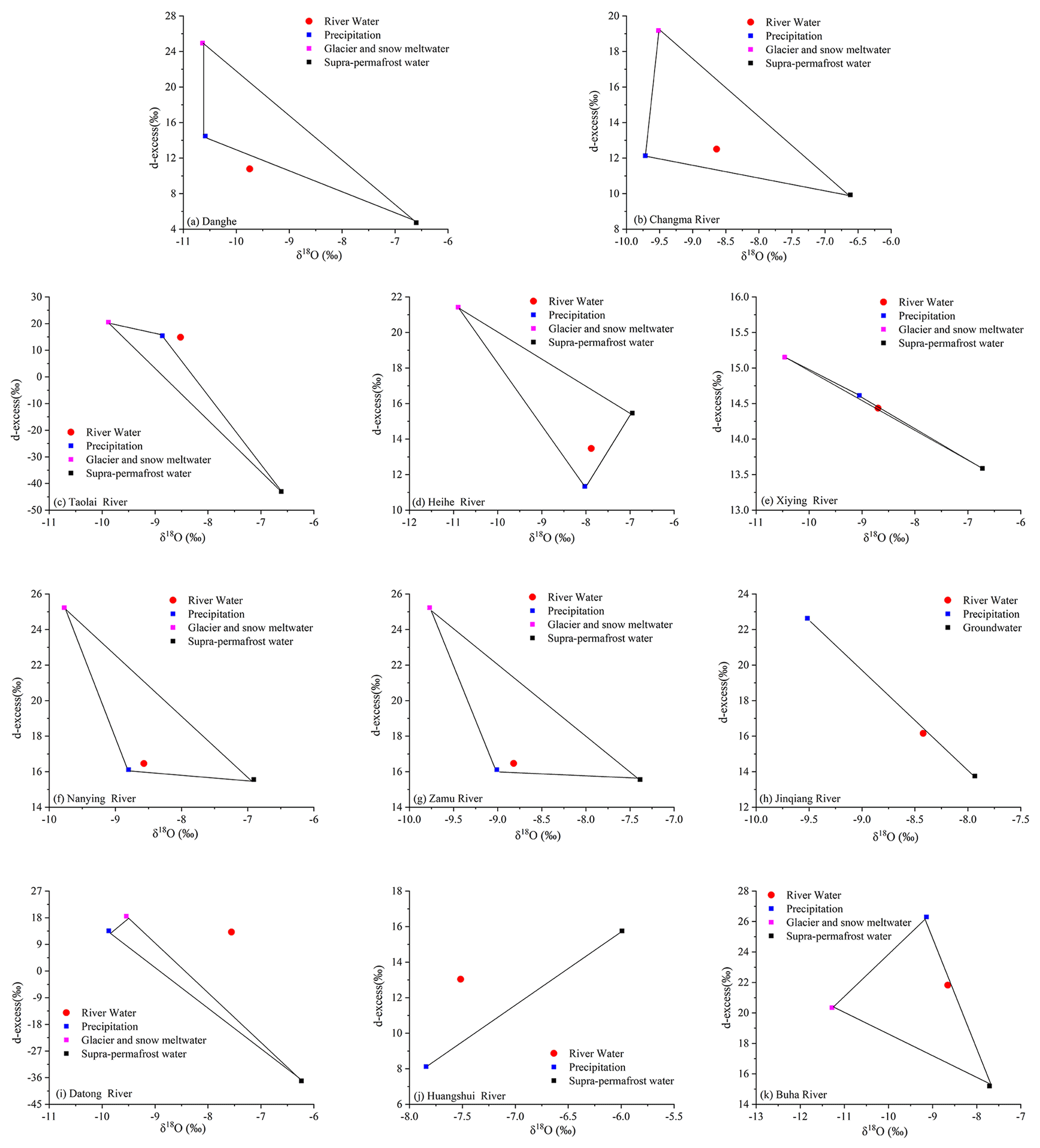
Figure 9Mixing diagram using the mean values of δ18O and d-excess for river water in the Qilian mountains.
Compared with the HIRS, the contribution of glacier and snow meltwater to the runoff in the USYR was significantly lower, and among the three rivers, only the Datong River was weakly replenished by glacier and snow meltwater. The contribution ratios of the precipitation, supra-permafrost, and glacier and snow meltwater to the Datong River were 63 %, 35 %, and 2 %, respectively. The Jinqiang River was mainly replenished by precipitation and groundwater, which contributed 30 % and 70 %, respectively, while the Huangshui River was mainly replenished by precipitation and supra-permafrost water, which contributed 83 % and 17 %, respectively. Located in the QIRS, the Buha River was mainly replenished by precipitation, supra-permafrost, and glacier and snow meltwater, with the contributions of the three end-members to the runoff being 58 %, 40 %, and 2 %, respectively.
Studies have shown that runoff in inland river basins in China is mainly derived from precipitation in mountainous areas, supra-permafrost, and glacier and snow meltwater. Zhou et al. (2000) and Zongxing et al. (2016b) determined that the elevation of mountain runoff is approximately 3500 m, according to the elevation effect of δ18O in the precipitation of the Qilian Mountains, which is 0.18 ‰ per 100 m. These facts show that the water resources of the Qilian Mountains mainly originate from the upper reaches of the mountain area. As the permafrost boundary is 3600 m in the Qilian Mountains (Zhou et al., 2000), and the altitude at which the river flows from the mountains in the USYR and QIRS is higher, with 3700 m as the boundary, the mountainous area was divided into the cryosphere and vegetation belt. EMMA was then used to calculate the contributions of the cryosphere and vegetation belts to mountain runoff from the three major water systems in the Qilian Mountains.
For the HIRS, the δ18O values in the precipitation of the cryosphere and vegetation belts were −9.02 ‰ and −7.32 ‰, respectively. Calculation using a binary mixed segmentation model showed that the contribution ratio of the cryosphere belt to the HIRS reached 82 %, consisting of precipitation, glacier and snow meltwater, and supra-permafrost water at 50 %, 9 %, and 23 %, respectively; the remaining 18 % was contributed by precipitation in the vegetation belt below 3600 m.
Similarly, the δ18O values in the precipitation in the cryosphere and vegetation belts in the USYR were −10.74 ‰ and −8.42 ‰, respectively. The contribution ratio of the cryosphere belt was 71 % of runoff (comprising precipitation, glacier and snow meltwater, and supra-permafrost water at 43.5 %, 24 %, and 3.5 %, respectively), and that of the vegetation belt was 29 %. In the QIRS, the δ18O values in the precipitation of the cryosphere and vegetation belts were −12.29 ‰ and −8.95 ‰, respectively. Calculations using the binary mixed segmentation model showed that the contribution of the cryosphere belt to the runoff was 80 % (comprising precipitation, glacier and snow meltwater, and supra-permafrost water at 38 %, 2 %, and 40 %, respectively), and that of the vegetation belt was 20 % (Figs. 10 and 11).
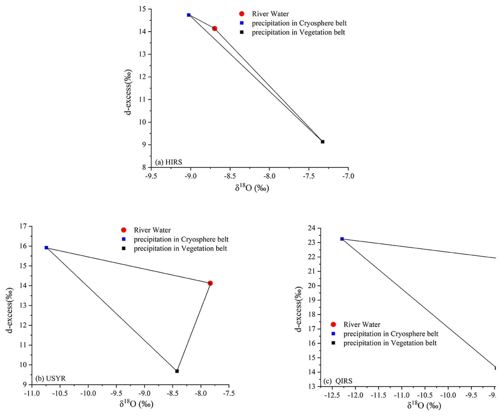
Figure 10Mixing diagram using the mean δ18O and d-excess values for the outlet runoff in the (a) HIRS, (b) USYR, and (c) QIRS.
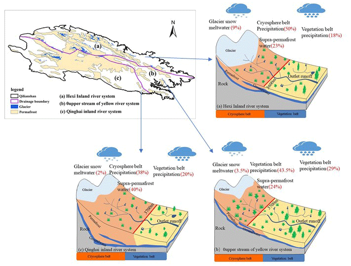
Figure 11Conceptual model of the contribution of the cryosphere belt and vegetation belt to runoff in the (a) Hexi inland river system, (b) upper stream of the Yellow River system, and (c) Qinghai inland river system.
Using the approach shown in Eq. (5), the uncertainty originating from the variation in the tracers of components and measurement methods can be calculated separately (Pu et al., 2013). The uncertainty was estimated to be 0.04 for the three-component mixing model in the study region. The uncertainty terms for the supra-permafrost water accounted for more than 47 % of the total uncertainty, indicating that the δ18O variations in the supra-permafrost water accounted for the majority of the uncertainty. Although there is some uncertainty in hydrograph separation, isotope-based hydrograph separations are still valuable tools for evaluating the contribution of meltwater to water resources and particularly helpful for improving the understanding of hydrological processes in cold regions, where there is a lack of observational data.
3.4 Hydrological processes
The runoff process in the Qilian Mountains occurs mainly from May to October and is influenced by glacier and snow meltwater, precipitation, and freezing and thawing processes in different ways and months; therefore, the monthly runoff components were segmented according to the daily isotope values from May to October (Fig. 12). In May, the temperature and precipitation gradually increased, causing the glacier, snow, and permafrost active layer to melt gradually. Snowmelt runoff increased with increasing temperature and, together with precipitation, replenished the river. Snow meltwater and supra-permafrost water in the surface layer are generally blocked by the frozen layer, which directly merges into river recharge runoff and becomes an important part of the spring runoff; this is also the main reason for spring floods in inland rivers. As shown in Fig. 12, the contribution of glacier and snow meltwater to river runoff in all three river systems was the largest in May. For this period, the contributions of glacier and snow meltwater to runoff in the HIRS, USYR system, and QIRS were approximately 16 %, 3 %, and 7 %, respectively, which were significantly higher than those of the average level of the entire growing season. As the temperatures continue to rise and precipitation continues to increase in June, the snow melts rapidly, but reserves continue to decline. With the thawing of the soil at the top of the permafrost active layer, the contribution of supra-permafrost water to runoff is further enhanced, but precipitation still plays a leading role. Hence, in June, the contribution of precipitation to the runoff from mountains in the HIRS, USYR system, and QIRS was 73 %, 64 %, and 72 %, respectively.

The temperature and precipitation in July and August reached the highest value in the study period, with the melting depth of the active layer for permafrost further increased and the water absorption enhanced. Thus, the precipitation and surface water can be quickly transformed into groundwater in the active layer of permafrost. In steep terrains, it rapidly replenishes runoff in the form of spring water, whereas in relatively flat terrains, it slowly replenishes runoff in the form of groundwater, which becomes an important part of runoff in cold regions; hence, the contribution of supra-permafrost water to runoff further increased. However, in the warmer months, the snow completely melted, but the massive increase in rainfall, instead, had a leading role in runoff, particularly in August when the contribution ratio of precipitation to the Huangshui and Zamu rivers was as high as 90 %. Although the glacier and snow meltwater flows remained unchanged, the total flow at this time was larger than that in May and June, resulting in a lower contribution ratio of glacier meltwater.
From September to October, the temperature and precipitation began to decline, and the saturated active layer of the permafrost began to release water; the contribution of supra-permafrost water to runoff was at its highest level in a year, particularly in October, with more than half of the runoff in many rivers, including the Changma (57 %), Heihe (59 %), Datong (57 %), and Buha rivers (65 %) (Fig. 12), originating from the supra-permafrost water. However, the contribution of glacier and snow meltwater remained high, owing to the significant decrease in the overall runoff and relative decrease in the precipitation. In conclusion, from May to October, the runoff from the Qilian Mountains is dominated by precipitation, and it plays an imperative role from July to August. However, with the thickening of the permafrost active layer, the contribution ratio of the permafrost active layer to runoff from May to October increased. The contribution ratio of glacier and snow meltwater to runoff in the Qilian Mountains was relatively low overall, and the highest value occurred in May, whereas the contribution ratio was relatively low in July–August when the temperature was relatively high.
It can be seen from the above analysis that precipitation has an absolute replenishment effect on rivers in the Qilian Mountains. In some rivers, precipitation contributed more than 80 % to the runoff, except for the Jinqiang River, which mainly relies on groundwater; more than half of the recharge of the other rivers are from precipitation. In the HIRS, the contribution of precipitation to runoff increased from west to east. In the western section of the Qilian Mountains, the contribution of precipitation to the Shule River was between 50 % and 65 %. For the Heihe River, located in the middle of the Qilian Mountains, the contribution of precipitation was approximately 60 %–70 %, and in the Shiyang River, in the eastern part of the Qilian Mountains, the contribution of precipitation was approximately 75 %–80 %. This regional difference was mainly caused by the spatial distribution differences in precipitation in the Qilian Mountains, which gradually increases from west to east. The contribution of precipitation to runoff was slightly lower in the USYR system and QIRS than in the HIRS.
4.1 Contribution of the cryosphere to runoff under changing environments
4.1.1 Contributions of glacier and snow meltwater to runoff
Glacier and snow meltwater are an important part of runoff in alpine mountains in western China. Different types and sizes of glaciers have different sensitivities to climate change that lead to significant differences in their processes of runoff yield and concentration. The contribution of glacier meltwater to mountain runoff showed significant spatial differences. Glacial meltwater and its contribution to runoff in cold basins are controlled by the number, size, area ratio, and storage capacity of glaciers in the basin. In general, the larger the scale of the glacier, the higher the ice reserves; more glacier and snow melting water can be provided. Secondly, climate conditions, especially temperature changes, have a great influence on the amount of glacier and snow melting water. As a result, the contribution of meltwater to runoff varies from river to river because of differences in the glaciers themselves and differences in climate conditions and sampling times. For the Baishui River in the Yulong Mountains, the two-component mixing model showed that an average of 53.4 % of runoff came from glacier and snow meltwater during the wet season (Pu et al., 2013). Maurya et al. (2011) found that the average contribution of meltwater to runoff is 32 % in typical glacial basins on the southern slope of the Himalayas, while in the western Himalayan region, the glacier and snow meltwater contribution has been estimated to be 35 % to 50 % of the river discharge (Laskar et al., 2018). The results suggested that the fraction of glacier and snow meltwater input over the total stream flow ranged from 84.50 % to 86.52 % in Hailuogou watershed on the eastern slope of Mount Gongga, China (Meng and Liu, 2013). In the Hengduan Mountains, hydrograph separation analysis showed that the contribution to runoff from glacier and snow meltwater varied from 63.8 % to 92.6 % (Liu et al., 2008). The contribution of glacial melt to the annual runoff varied greatly among the basins, with approximately 22.3 %, 25.2 %, 34.6 %, and 79 % for the source regions of the Mekong, Salween, Brahmaputra, and Indus, respectively (Zhang et al., 2013). In the source regions of the Yangtze River, meltwater accounted for 23 % of river water at the Tuotuohe station from June 2016 to May 2018, while the corresponding value at the Zhimenda station was 17 % (Li et al., 2020a, b). In the USYR, the contribution of snow and ice meltwater to runoff was approximately 23 %. In the Kunlun Mountains, the average contribution of meltwater to runoff in the Tizinafu River was 43 % (Fan et al., 2015), and in the Urumqi River, it was 14.7 %, while in the Kumalak River, the contribution was more than 57 % (Congjian et al., 2015; Kong and Pang, 2012) (Fig. 13).
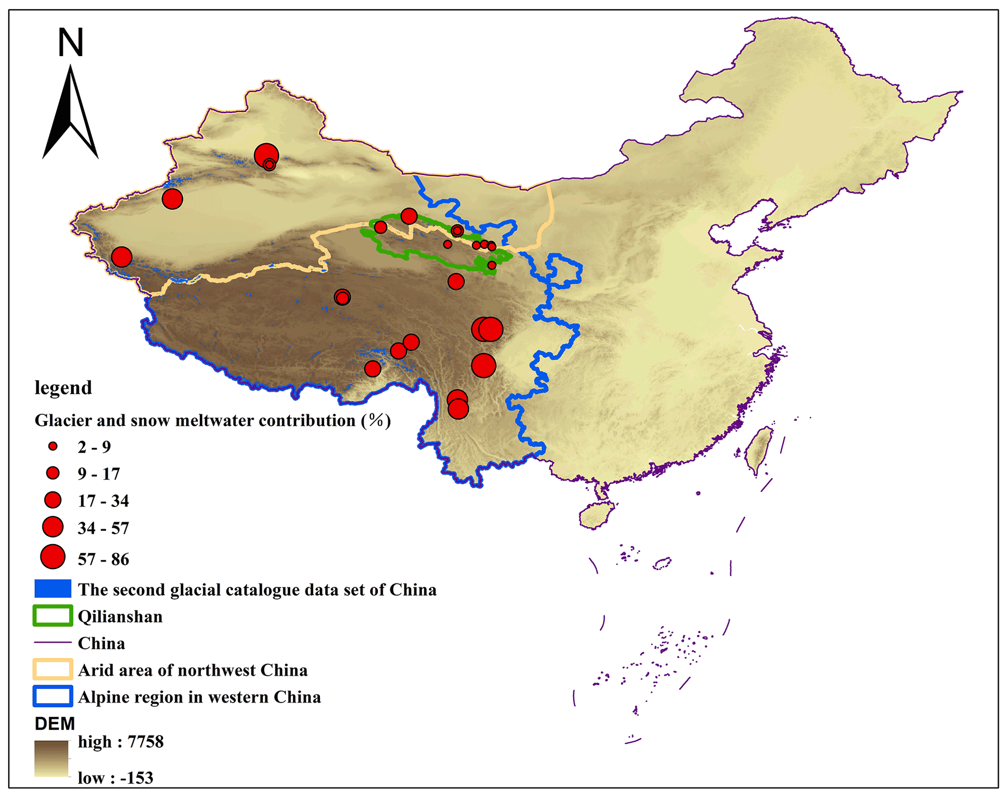
Figure 13Contribution of glacier and snow meltwater to runoff in alpine regions of China.
As solid reservoirs, glacier retreat will inevitably lead to a reduction in total water resources. Glacier meltwater runoff increases when the glacier is degraded and then tends to decrease as the glacier area decreases (Weiming et al., 2012). During 1960–2019, the Qilian Mountains showed an overall warming trend with an average annual temperature rise of 0.319 ∘C a−1 (Ye et al., 2022). Under the influence of global warming, glaciers have become shorter, narrower, and thinner, and statistical results showed that the glacier area of the Qilian Mountains in 1987, 1991, 1997, 2001, 2007, 2013, and 2018 was 2080.39, 1939.12, 1805.65, 1691.13, 1619.26, 1531.21, and 1442.09 km2, respectively. During 1987–2018, the glacier area was in continuous retreat, at an average annual rate of 1.34 % during 1987–2001 and 0.87 % during 2001–2018 (Yingzheng et al., 2020). The massive retreat of glaciers will inevitably have a large impact on glacial meltwater runoff.
4.1.2 Contribution of permafrost to runoff
In cold watersheds, winter precipitation is solid and cannot directly recharge rivers, so winter runoff mainly comes from groundwater. In the long term, the active layer of permafrost is also a solid water source, and permafrost degradation will lead to thickening of its active layer, which in turn will cause an increase in the permafrost water storage capacity and groundwater volume, ultimately causing changes in the hydrological processes and seasonal structure of runoff in cold regions. Permafrost is widely distributed in the Qilian Mountains, which are mainly characterized by steep topography, sparse vegetation, and cold climate, and it plays an important role in the exchange of surface and groundwater within the basin, as well as in the intra-annual distribution (Cheng and Wu, 2007). On the one hand, the increased depth of the active layer of permafrost reduces the depth of the water barrier, thereby reducing direct runoff, and on the other hand, as the active layer deepens, the frozen water stored in the active layer will be released, thereby recharging runoff. The effect of temperature on runoff is a complex interaction of various factors.
The spatial and temporal distributions and hydrothermal characteristics of different types of permafrost differ to some extent, which leads to significant differences in hydrological processes. The above analysis confirms that supra-permafrost water is also an important part of the runoff from the Qilian Mountains. In some months, its contribution to runoff from the mountains can reach more than 60 %. The contribution of supra-permafrost water to runoff from mountains shows obvious spatiotemporal characteristics. In terms of time, the contribution ratio gradually increases from May to October, and the largest contribution ratio appears in October. In terms of spatial distribution characteristics, the contribution is significantly higher in the Datong River of the USYR system and the Buha River of the QIRS than in the HIRS. This is mainly related to the spatial distribution and thickness of the permafrost. In the Qilian Mountains, the average contribution of supra-permafrost water to runoff from May to October is 10 %–40 %, while in the source region of the Yangtze River in China, due to the widespread distribution of permafrost, the contribution is generally over 40 % (Li et al., 2020a).
4.2 Hydrological effects of cryospheric change
4.2.1 Runoff changes
Numerous studies have shown that under global warming, glacier degradation and precipitation have continued to increase in the study area, resulting in a significant increase in runoff in the Qilian Mountains since 1990 (Li et al., 2019; Bo et al., 2010). Therefore, the runoff variation after 1990 in the study area was analyzed. As shown in Fig. 14, from 1990 to 2020, the seven rivers in the HIRS all showed an increasing trend. The increasing rates of runoff in the Danghe, Changma, Taolai, Heihe, Xiying, Nanying, and Zamu rivers were 0.16×10⁸, 2.7×10⁸, 0.48×10⁸, 2.6×10⁸, 0.36×10⁸, 0.04×10⁸, and 0.01×10⁸ m3 per 10 years, respectively. Accordingly, the peak runoff of the seven rivers appeared in 2019 (5.057×10⁸ m3), 2017 (17.43×10⁸ m3), 2018 (7.82×10⁸ m3), 2017 (23.31×10⁸ m3), 2019 (4.416×10⁸ m3), 1993 (1.738×10⁸ m3), and 2003 (3.542×10⁸ m3), respectively (Fig. 14).

In the USYR system, the runoff of the Datong and Huangshui rivers still showed an increasing trend, with rates of 1.3×10⁸ and 1.55×10⁸ m3 per 10 years, respectively. The runoff of the Jinqing River showed a decreasing trend, but the rate was very slow ( m3 per 10 years). In summary, after 1990, runoff from the Qilian Mountains generally showed an increasing trend, and similar studies have shown that global warming has increased runoff from rivers that are heavily affected by glacier recharge. Based on the annual runoff data from 1951 to 2000, the results show that the runoff of most rivers in western China has been increasing (Baisheng et al., 2006), particularly since 1980. The runoff from mountains in Xinjiang has increased significantly, with a maximum increase of 40 % (Yongjian et al., 2020).

Figure 15Seasonal variation of runoff after 1990 in the Hexi inland river system: (a) Danghe River, (b) Changmahe River, (c) Taolai River, (d) Heihe River, (e) Xiying River, (f) Nanying River, and (g) Zamu River.
4.2.2 Seasonal structure of runoff
The seasonal patterns of runoff have also changed over the past 30 years, for example, the time of maximum monthly runoff in some rivers is changing. As shown in Fig. 15, except for the Danghe and Changma rivers, the runoff peaks of the other five rivers have all changed in the HIRS. From 1990 to 2020, the time of peak runoff in the Heihe River was delayed from July to August, but in the other six rivers, it advanced from August to July. This was closely related to the mass melting of the glaciers. Glacier meltwater runoff is mainly influenced by two factors: temperature and the size of the glacial reserves and area. In the context of global warming, the climate of northwest China was warm and dry from the end of the Little Ice Age to the 1980s and began to change to warm and humid around 1990 (Yafeng et al., 2003). The results show that the warming of the annual mean temperature in the Qilian Mountains from 1991 to 2016 was twice as much as that in the period of 1961–1990, making the ablation period in the Qilian Mountains longer (Zongxing et al., 2019). This caused the glacier snowpack to start melting earlier and combine with heavy precipitation to form a flood season. Regardless of whether the peak runoff was advanced or retarded, it was still concentrated in July and August in the HIRS. The peak runoff of the Jinqiang River in the USYR moved from August to September (Fig. 15).
4.2.3 Winter runoff increases
Global warming has caused a temperature rise and active layer thickening of the permafrost in the Qinghai–Tibet Plateau of China (Cheng and Wu, 2007). Monitoring results show that the permafrost has been continuously degraded in the past few decades, and statistical model estimations show that the thickness of the active layer along the Qinghai–Tibet Highway has increased significantly from 1981 to 2018, with an average change rate of 19.5 cm per 10 years; much of the underground ice that had been trapped near the upper boundary of the permafrost has melted (Lin et al., 2010; Ren et al., 2012). The distribution of permafrost in the Qilian Mountains in the 1960s, 1970s, 1980s, 1990s, the first decade of the 21st century, and 2010–2015 was 0.61×10⁴, 0.58×10⁴, 0.57×10⁴, 0.50×10⁴, 0.42×10⁴, and 0.43×10⁴ km2, respectively (Chen et al., 2019). Permafrost degradation increases the infiltration rate of the soil, resulting in the weakening or even loss of the water barrier effect of the permafrost layer. In summer, an increase in the depth of permafrost thaw increases the recharge of groundwater from precipitation, while some underground ice melts and the area of the thaw zone expands, thus increasing the recharge of winter runoff (Clark et al., 2001).
The winter runoff (total runoff in January, February, and December) of some rivers in the Qilian Mountains increased after 1990. For example, the winter runoff of the Changma River in the HIRS was 0.759×10⁸ m3 in 1990–2000, 1.175×10⁸ m3 in 2001–2010, and 1.250×10⁸ m3 in 2011–2020, representing an increase of approximately 25 %. The winter runoff of the Heihe River was 1.114×10⁸ m3 in 1990–2000, 1.225×10⁸ m3 in 2001–2010 and 1.320×10⁸ m3 in 2011–2020, representing an increase of approximately 18.5 %. Similarly, winter runoff increased by approximately 6 % and 57 % in the Nanying and Zamu rivers, respectively. A similar situation occurred in the USYR (Fig. 15); the winter runoff of the Datong River was 1.432×10⁸ m3 in 1990–2000, 1.629×10⁸ m3 in 2001–2010, and 2.280×10⁸ m3 in 2011–2020, representing an increase of approximately 59 %. This is mainly because permafrost degradation has led to further weakening of the permafrost water barrier, thereby changing the groundwater reservoir storage capacity and drainage paths. At the same time, glacier melt has accelerated, resulting in mixing of glacier meltwater and rainfall that recharges groundwater and subsequent monthly runoff in the form of baseflow (Chen et al., 2019). Similar results have been reported for other cold regions of the world. For example, analysis and simulation of runoff changes showed that, owing to the decline of permafrost and change in the thawing process, the winter runoff in the European parts of Russia has increased significantly by as much as 50 %–120 % (Kalyuzhnyi and Lavrov, 2012). In a typical basin of the northern slope of the Himalayas during the cold period (from November to March of the following year), the runoff increased by different amounts, particularly in January, and increased by 67 % in the last 10 years compared with that of the previous 10 years (Fei et al., 2006). Studies on rivers in the Qinghai–Tibet Plateau, Tianshan Mountains, northeast China, and other regions of China have found that permafrost degradation leads to an increase in winter runoff, which is consistent with the trend of frozen soil degradation over time (Liu et al., 2003; Tongliang et al., 2006).
4.3 Implications for water resource management
Water resources are a key factor limiting the development of the arid zone in northwest China. In these regions, water resources mainly come from the surrounding mountains; therefore, changes in mountain runoff will directly affect socioeconomic activities (Baisheng et al., 2008). According to the results in this study, 82 %, 71 %, and 80 % of the runoff in the HIRS, USYR system, and QIRS, respectively, come from the cryosphere belt above m altitude in the Qilian Mountains. Kang et al. (2008) also confirmed that the contribution ratio of the cryosphere belt to mountain runoff in the HIRS was 83 %, based on the water balance.
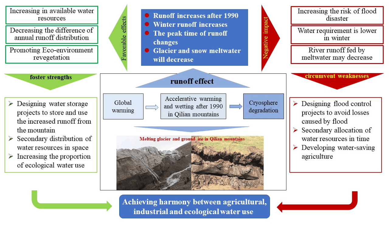
Figure 16Conceptual model of runoff change, water resource effect, and countermeasures under global warming in the Qilian Mountains.
These facts indicate that the water resource security of inland river basins in China is highly dependent on the stability of the cryosphere belt. The severe retreat of the cryosphere after 90 years has changed the characteristics of runoff, such as a rapid increase in volume, change in the peak time, and increase during winter. More seriously, as the glacier shrinks and its area decreases, the amount of glacial meltwater is bound to decrease at some point in the future, which is called the inflection point of the glacial meltwater increase to decrease, also known as the peak of glacial meltwater (Yongjian et al., 2020). These changes will pose challenges to water security in the future. Model predictions also indicate future glacial meltwater reductions of approximately 34 %, 62 %, and 74 % by the end of the 21st century under the RCP2.6 (low), RCP4.5 (medium), and RCP8.5 (high) discharge scenarios, respectively (Yingsong et al., 2012; Zhao et al., 2019). Against the background of changing water resources, the Gansu and Qinghai provinces, which depend on the Qilian Mountains for water supply, will also actively adjust their water-use strategies. From 2010 to 2019, the total utilization of water resources in these provinces showed a downward trend. Among them, the agricultural irrigation and industrial water consumption showed a downward trend, while the water consumption for forestry, husbandry, fishery, livestock, comprehensive living, and ecological environment showed an upward trend. The structure of water use in Gansu and Qinghai is still dominated by agricultural water, which accounts for more than 70 % of the total water consumption, whereas ecological water use remains less than 10 % (Hou et al., 2021).
In conclusion, runoff from the Qilian Mountains has shown a pronounced increasing trend in recent decades, and the runoff composition has changed to some extent. However, it is predicted that the contribution of meltwater to runoff will decrease significantly in the future as glaciers melt substantially. This will lead to reduced runoff in basins where glacial meltwater contributes more to runoff.
Changes in runoff and its composition have resulted in many opportunities. For example, increased runoff means that there are more water resources to use, and in winter the uneven distribution of runoff during the year can be effectively alleviated. More importantly, it provides good conditions for ecological restoration and protection in arid areas. However, sudden increases in runoff and changes in runoff peaks indicate an increased risk of flooding. At the same time, the increase in runoff in winter does not match the main period of use for local production and living, and the utilization efficiency of this part of the water resource is not high; an increase in runoff may not be sustainable. In the future, with the continuous decrease in glacier area and numbers, the amount of runoff from glacier and snow meltwater will decrease, which is likely to lead to a decrease in runoff from mountains, bringing great loss to local economic and social development. Based on the current situation of water resources, the following suggestions are proposed (Fig. 16):
-
Strengthen the capacity for water storage and release by designing water supply and flood control projects. Owing to the restrictions on economic and social conditions, development ideas, and water resource conditions at that time, water conservancy projects, such as reservoirs built in the early years have been unable, to some extent, to meet and cope with the current situation of increasing mountain runoff. Therefore, it is necessary to continually improve regional water supply and flood control capacity. It is necessary to consider storing more water for use in the dry season, and it is also necessary to strengthen the awareness and ability to cope with flood disasters and flexibly respond to changes in water resources.
-
Redistribute water resources over time according to actual water use. In the oasis areas that depend on the water resources of the Qilian Mountains, the water use structure is mainly agricultural; however, agricultural activities have relatively fixed amounts and times, and their requirements often cannot completely adapt to the situation of natural water supply, especially in the current context of increased winter runoff. On the one hand, the increased runoff in winter can be stored for use in the dry season through water conservancy projects and other measures. On the other hand, agricultural irrigation methods can be adjusted appropriately, such as replacing winter irrigation with spring irrigation.
-
Strengthen regional communication and cooperation to reallocate water resources. Although the runoff from mountains has generally shown an increasing trend in recent decades in the study area, this is not uniform in space, and some regions even show negative growth, which leads to a more uneven distribution of water resources in space. To better adapt to this situation, each region should build and improve the interbasin water transfer project according to the actual situation, adjusting the remaining water resources efficiently to realize the optimal allocation of water resources.
-
Accelerate the reform of water-saving agriculture and actively address the impact of glacier and snow meltwater on agriculture. It is predicted that with the continuous decrease in glacier reserves, the contribution from glacier and snow meltwater to runoff from mountains will decrease in the future, which will significantly reduce runoff where glacier and snow meltwater is the main recharge source. To deal with the impact of water resource reduction on agriculture, on the one hand, we should vigorously promote water-saving irrigation; on the other hand, we should promote drought-resistant tillage and cultivation methods. By applying various measures to seek advantages and avoid disadvantages, the harmony of life, agriculture, industry, and ecological water use can be realized.
Based on the isotopic data of 1310 precipitation, 338 river water, 96 glacier and snow meltwater, 108 supra-permafrost water, and 312 groundwater samples, this study quantified the runoff components of 11 major rivers in the Qilian Mountains and investigated the influence of cryosphere changes on runoff from mountains. It was found that the stable isotopes of river water and groundwater in the study area were relatively invariable, unlike that of precipitation, which showed significant seasonal variations. The annual mean values of δ18O in the river and groundwater in the Qilian Mountains were −8.49 ‰ and −8.76 ‰, respectively.
The stable isotope relationships of various waters showed that the river water was fed by precipitation, glacier and snow meltwater, and supra-permafrost water. EMMA was used to determine the contribution ratios of different water bodies to runoff. The calculations showed that precipitation was the main recharge source of seven rivers in the HIRS; the contribution ratios to the Danghe, Changma, Qiaolai, Heihe, Xiying, Nanying, and Zamu rivers being 65 %, 51 %, 69 %, 59 %, 75 %, 80 %, and 79 %, respectively. Supra-permafrost water was also an important recharge source for the HIRS. The contribution of supra-permafrost water to the Dang, Changma, Taolai, Heihe, Xiying, Nanying, and Zamu rivers was approximately 21 %, 33 %, 20 %, 33 %, 19 %, 15 %, and 16 %, respectively. As the third end-member, the corresponding glacier and snow meltwater contributed approximately 14 %, 16 %, 11 %, 8 %, 6 %, 5 %, and 5 % to runoff, respectively. In the USYR system, the contribution of glacier and snow meltwater to the runoff was notably low. The contribution ratios of precipitation, supra-permafrost, and glacier and snow meltwater to the Datong River was 63 %, 35 %, and 2 %, respectively. The Jinqiang River was mainly replenished by precipitation and groundwater, which contributed 30 % and 70 %, respectively, while the Huangshui River was mainly replenished by precipitation and supra-permafrost water, which contributed 83 % and 17 %, respectively. Located in the QIRS, the Buha River was mainly replenished by precipitation, supra-permafrost, and glacier and snow meltwater, with the contributions of these three end-members to the runoff being 58 %, 40 %, and 2 %, respectively.
Runoff in the inland rivers of the Qilian Mountains is mainly derived from the cryosphere belt. Calculations using a binary mixed segmentation model revealed that the contribution ratios of the cryosphere belt to mountain runoff in the HIRS, USYR system, and QIRS were 82 %, 71 %, and 80 %, respectively. Cryospheric changes have impacted hydrological processes in the Qilian Mountains. After the 1990s, the runoff from the Qilian Mountains generally increased rapidly, the peak time of runoff changed, and runoff showed an increasing trend in winter. These changes in hydrological processes provide both opportunities and challenges and require various measures to exploit advantages and avoid disadvantages to achieve harmony in ecological, living, and production water use.
The raw/processed data required to reproduce these findings cannot be shared at this time as the data also form part of an ongoing study. We will not share our data until all relevant results are completed.
JG led the write-up of the manuscript with significant contribution. ZL developed the research and designed the experiments. QF collected the water samples and analyzed the data. QC and JX modified the language. All authors discussed the results and contributed to the preparation of the manuscript.
The contact author has declared that none of the authors has any competing interests.
Publisher's note: Copernicus Publications remains neutral with regard to jurisdictional claims in published maps and institutional affiliations.
This research has been supported by the Regional Innovation and Development Joint Fund of the National Nature Science Foundation of China (U22A20592), the Excellent doctoral program in Gansu Province (22JR5RA052), the National Key Research and Development Program of China (grant no. 2020YFA0607702), Innovative Groups in Gansu Province (2020), the Second Tibetan Plateau Scientific Expedition and Research Program (STEP, grant no. 2019QZKK0405), and the “Western Light” Key Laboratory Cooperative Research Cross-Team Project of Chinese Academy of Sciences.
This paper was edited by Fuqiang Tian and reviewed by two anonymous referees.
Baisheng, Y. E., Yongjian, D., Daqing, Y., Tianding, H. A. N., and Yongping, S.: Regional Parttens of Climate the Last 50 Years Viewed Change in Northwest China during from Annual Discharge Change, J. Glaciol. Geocryol., 28, 307–311, 2006.
Baisheng, Y. E., Peng, C., Yongjian, D., Daqing, Y., Chong, L. I., and Yongping, S.: Discharge Changes of the Eight Large Rivers in East Asia during the Last More Than 100 Years, J. Glaciol. Geocryol., 30, 556–561, 2008.
Bo, C., Baotian, P., Hongshan, G., Shaofei, J., Yuhua, W., and Guandonghui, S.: Glacier Variation in the Lenglongling Range of Eastern Qilian Mountains from 1972 to 2007, J. Glaciol. Geocryol., 32, 242–248, 2010.
Bowen, G. J., Cai, Z., Fiorella, R. P., and Putman, A. L.: Isotopes in the Water Cycle: Regional- to Global-Scale Patterns and Applications, Annu. Rev. Earth Planet Sci., 47, 453–500, https://doi.org/10.1146/annurev-earth-053018-060220, 2019.
Cheng, G. and Wu, T.: Responses of permafrost to climate change and their environmental significance, Qinghai-Tibet Plateau, J. Geophys. Res.-Earth, 112, F02S03, https://doi.org/10.1029/2006JF000631, 2007.
Chen, R., Zhang, S,, and Yang, Y.: Effects of cryospheric changes on runoff in cold regions of western China, Science Press, ISBN 9787030581365, 2019.
Clark, I. D., Lauriol, B., Harwood, L., and Marschner, M.: Groundwater contributions to discharge in a permafrost setting, Big Fish River, NWT, Canada, Arct. Antarct. Alp. Res., 33, 62–69, https://doi.org/10.2307/1552278, 2001.
Congjian, S., Weihong, L., Yaning, C., Xingong, L., and Yuhui, Y.: Isotopic and hydrochemical composition of runoff in the Urumqi River, Tianshan Mountains, China, Environ. Earth Sci., 74, 1521–1537, https://doi.org/10.1007/s12665-015-4144-x, 2015.
Cui, B.-L. and Li, X.-Y.: Runoff processes in the Qinghai Lake Basin, Northeast Qinghai-Tibet Plateau, China: Insights from stable isotope and hydrochemistry, Quatern. Int., 380, 123–132, https://doi.org/10.1016/j.quaint.2015.02.030, 2015.
Deng, S.: Impacts of climate change on vegetation in Qilian mountains from 2000 to 2011, Lanzhou University, https://kns.cnki.net/KCMS/detail/detail.aspx?dbname=CDFD1214&filename=1013239281.nh (last access: 2 January 2023), 2013.
Fan, Y., Chen, Y., Li, X., Li, W., and Li, Q.: Characteristics of water isotopes and ice-snowmelt quantification in the Tizinafu River, north Kunlun Mountains, Central Asia, Quatern. Int., 380, 116–122, https://doi.org/10.1016/j.quaint.2014.05.020, 2015.
Fei, Z., Yingshi, L. I. U., and Tongliang, G.: Winter Runoff in a Typical Alpine Permafrost Region, Tibet-Himalayas, Adv. Earth Sci., 21, 1333–1338, 2006.
Florke, M., Schneider, C., and McDonald, R. I.: Water competition between cities and agriculture driven by climate change and urban growth, Nat. Sustain., 1, 51–58, https://doi.org/10.1038/s41893-017-0006-8, 2018.
Gat, J. R., Shemesh, A., Tziperman, E., Hecht, A., Georgopoulos, D., and Basturk, O.: The stable isotope composition of waters of the eastern Mediterranean Sea, J. Geophys. Res.-Oceans, 101, 6441–6451, https://doi.org/10.1029/95JC02829, 1996.
Genereux, D.: Quantifying uncertainty in tracer-based hydrograph separations, Water Resour. Res., 34, 915–919, https://doi.org/10.1029/98WR00010, 1998.
Hooper, R. P.: Diagnostic tools for mixing models of stream water chemistry, Water Resour. Res., 39, 1055, https://doi.org/10.1029/2002WR001528, 2003.
Hooper, R. P. and Shoemaker, C. A.: A Comparison Of Chemical And Isotopic Hydrograph Separation, Water Resour. Res., 22, 1444–1454, https://doi.org/10.1029/WR022i010p01444, 1986.
Hou, Y., Li, C., Nie, Y., and Xu, T.: Analysis on decoupling effect and driving factors between water resources utilization and economic growth in Gansu Province, Water Resources and Hydropower Engineering, 1–15, https://doi.org/10.13928/j.cnki.wrahe.2022.05.006, 2021.
Immerzeel, W. W., van Beek, L. P. H., and Bierkens, M. F. P.: Climate Change Will Affect the Asian Water Towers, Science, 328, 1382–1385, https://doi.org/10.1126/science.1183188, 2010.
IPCC: Summary for Policymakers. Climate Change 2013: The Physical Science Basis, in: Contribution of Working Group I to the Fifth Assessment Report of the Intergovernmental Panel on Climate Change, Cambridge, UK and New York, NY, USA, ISBN 978-1-107-05799-1, 2013.
Juan, G., Li, Z., Qi, F., Ruifeng, Y., Tingting, N., Baijuan, Z., Jian, X., Wende, G., Fusen, N., Weixuan, D., Anle, Y., and Pengfei, L.: Environmental effect and spatiotemporal pattern of stable isotopes in precipitation on the transition zone between the Tibetan Plateau and arid region, Sci. Total Environ., 749, 141559, https://doi.org/10.1016/j.scitotenv.2020.141559, 2020.
Kalyuzhnyi, I. L. and Lavrov, S. A.: Basic Physical Processes and Regularities of Winter and Spring River Runoff Formation under Climate Warming Conditions, Russ. Meteorol. Hydrol., 37, 47–56, https://doi.org/10.3103/S1068373912010074, 2012.
Kang, E. S., Chen, R. S., and Zhang, Z. H.: Study on mountainous hydrology and ecology in inland basins of China, Adv. Earth Sci., 23, 675–681, 2008.
Klaus, J. and McDonnell, J. J.: Hydrograph separation using stable isotopes: Review and evaluation, J. Hydrol., 505, 47–64, https://doi.org/10.1016/j.jhydrol.2013.09.006, 2013.
Kong, Y. and Pang, Z.: Evaluating the sensitivity of glacier rivers to climate change based on hydrograph separation of discharge, J. Hydrol., 434, 121–129, https://doi.org/10.1016/j.jhydrol.2012.02.029, 2012.
Kriegel, D., Mayer, C., Hagg, W., Vorogushyn, S., Duethmann, D., Gafurov, A., and Farinotti, D.: Changes in glacierisation, climate and runoff in the second half of the 20th century in the Naryn basin, Central Asia, Global Planet. Change, 110, 51–61, https://doi.org/10.1016/j.gloplacha.2013.05.014, 2013.
Laskar, A. H., Bhattacharya, S. K., Rao, D. K., Jani, R. A., and Gandhi, N.: Seasonal variation in stable isotope compositions of waters from a Himalayan river: Estimation of glacier melt contribution, Hydrol. Process., 32, 3866–3880, https://doi.org/10.1002/hyp.13295, 2018.
Li, Z., Qi, F., Li, J., Pan, Y., Wang, T., Li, L., Xiaoyan, G., Yan, G., Bing, J., and Rui, G.: Environmental significance and hydrochemical processes at a cold alpine basin in the Qilian Mountains, Environ. Earth Sci., 73, 4043–4052, https://doi.org/10.1007/s12665-014-3689-4, 2015.
Li, Z., Gui, J., Wang, X., Feng, Q., Zhao, T., Ouyang, C., Guo, X., Zhang, B., and Shi, Y.: Water resources in inland regions of central Asia: Evidence from stable isotope tracing, J. Hydrol., 570, 1–16, https://doi.org/10.1016/j.jhydrol.2019.01.003, 2019.
Li, Z.-J., Li, Z.-X., Song, L.-L., Gui, J., Xue, J., Zhang, B. J., and Gao, W. de: Hydrological and runoff formation processes based on isotope tracing during ablation period in the source regions of Yangtze River, Hydrol. Earth Syst. Sci., 24, 4169–4187, https://doi.org/10.5194/hess-24-4169-2020, 2020a.
Li, Z.-J., Li, Z.-X., Fan, X.-J., Wang, Y., Song, L.-L., Gui, J., Xue, J., Zhang, B.-J., and Gao, W.-D.: The sources of supra-permafrost water and its hydrological effect based on stable isotopes in the third pole region, Sci. Total Environ., 715, 136911, https://doi.org/10.1016/j.scitotenv.2020.136911, 2020b.
Lin, Z., Yong-jian, D., Guang-yue, L. I. U., Shao-ling, W., and Hui-jun, J. I. N.: Estimates of the Reserves of Ground Ice in Permafrost Regions on the Tibetan Plateau, J. Glaciol. Geocryol., 32, 1–9, 2010.
Liu, F. J., Williams, M. W., and Caine, N.: Source waters and flow paths in an alpine catchment, Colorado Front Range, United States, Water Resour. Res., 40, W09401, https://doi.org/10.1029/2004WR003076, 2004.
Liu, S. Y., Sun, W. X., Shen, Y. P., and Li, G.: Glacier changes since the Little Ice Age maximum in the western Qilian Shan, northwest China, and consequences of glacier runoff for water supply, J. Glaciol., 49, 117–124, https://doi.org/10.3189/172756503781830926, 2003.
Liu, X., Yang, L., and Wang, F.: An Analysis of Runoff Evolution Law in Qinghai Lake Basin in the Past 60 Years, China's Rural Water and Hydropower, 11, 1–13, 2020.
Liu, Y., Fan, N., An, S., Bai, X., Liu, F., Xu, Z., Wang, Z., and Liu, S.: Characteristics of water isotopes and hydrograph separation during the wet season in the Heishui River, China, J. Hydrol., 353, 314–321, https://doi.org/10.1016/j.jhydrol.2008.02.017, 2008.
Maurya, A. S., Shah, M., Deshpande, R. D., Bhardwaj, R. M., Prasad, A., and Gupta, S. K.: Hydrograph separation and precipitation source identification using stable water isotopes and conductivity: River Ganga at Himalayan foothills, Hydrol. Process., 25, 1521–1530, https://doi.org/10.1002/hyp.7912, 2011.
McDonnell, J. J., Stewart, M. K., and Owens, I. F.: Effect Of Catchment-Scale Subsurface Mixing On Stream Isotopic Response, Water Resour. Res., 27, 3065–3073, https://doi.org/10.1029/91WR02025, 1991.
Meiping, S., Shiyin, L., Xiaojun, Y., Wanqin, G., and Junli, X.: Glacier changes in the Qilian Mountains in the past half century: Based on the revised First and Second Chinese Glacier Inventory, Acta Geogr. Sin., 70, 1402–1414, 2015.
Meng, Y. and Liu, G.: Stable isotopic information for hydrological investigation in Hailuogou watershed on the eastern slope of Mount Gongga, China, Environ. Earth Sci., 69, 29–39, https://doi.org/10.1007/s12665-012-1931-5, 2013.
Miller, S. A., Mercer, J. J., Lyon, S. W., Williams, D. G., and Miller, S. N.: Stable isotopes of water and specific conductance reveal complimentary information on streamflow generation in snowmelt-dominated, seasonally arid watersheds, J. Hydrol., 596, 126075, https://doi.org/10.1016/j.jhydrol.2021.126075, 2021.
Milly, P. C. D. and Dunne, K. A.: Colorado River flow dwindles as warming-driven loss of reflective snow energizes evaporation, Science, 367, 1252–1255, https://doi.org/10.1126/science.aay9187, 2020.
Mortatti, J., Moraes, J. M., Victoria, R. L., and Martinelli, L. A.: Hydrograph Separation of the Amazon River: A Methodological Study, Aquat. Geochem., 3, 117–128, https://doi.org/10.1023/A:1009606801595, 1997.
Pu, T., He, Y., Zhu, G., Zhang, N., Du, J., and Wang, C.: Characteristics of water stable isotopes and hydrograph separation in Baishui catchment during the wet season in Mt.Yulong region, south western China, Hydrol. Process., 27, 3641–3648, https://doi.org/10.1002/hyp.9479, 2013.
Ren, L., Lin, Z., YongJian, D., TongHua, W., Yao, X., ErJi, D., GuangYue, L., and YongPing, Q.: Temporal and spatial variations of the active layer along the Qinghai-Tibet Highway in a permafrost region, Chinese Sci. Bull., 57, 4609–4616, https://doi.org/10.1007/s11434-012-5323-8, 2012.
Rock, L. and Mayer, B.: Isotope hydrology of the Oldman River basin, southern Alberta, Canada, Hydrol. Process. 21, 3301–3315, https://doi.org/10.1002/hyp.6545, 2007.
Shengjie, W., Mingjun, Z., Zhongqin, L., Feiteng, W., Huilin, L., Yaju, L., and Xiaoyan, H.: Glacier area variation and climate change in the Chinese Tianshan Mountains since 1960, J. Geogr. Sci., 21, 263–273, https://doi.org/10.1007/s11442-011-0843-8, 2011.
Tiaofeng, Z., Xide, Z., Yongjian, W., Hongmei, L., and Caihong, L.: The Impact of Climate Variability and Human Activity on Runoff Changes in the Huangshui River Basin, Resour. Sci., 36, 2256–2262, 2014.
Tongliang, G., Changming, L. I. U., and Jingshi, L. I. U.: Hydrological Response of Lhasa River to Climate Change and Permafrost Degradation in Xizang, Acta Geogr. Sin., 61, 519–526, 2006.
Uhlenbrook, S., Frey, M., Leibundgut, C., and Maloszewski, P.: Hydrograph separations in a mesoscale mountainous basin at event and seasonal timescales, Water Resour. Res., 38, 1096, https://doi.org/10.1029/2001WR000938, 2002.
Wang, J.: Study of Mechanism and Process of Water Transmission on Resource Conservation Forests Ecosystem in Qilian Mountains, Central South University of Forestry and Technology, https://kns.cnki.net/KCMS/detail/detail.aspx?dbname=CDFD1214&filename=1011065151.nh (last access: 2 January 2023), 2006.
Weiming, C., Shangmin, Z., Chenghu, Z., and Xi, C.: Simulation of the Decadal Permafrost Distribution on the Qinghai-Tibet Plateau (China) over the Past 50 Years, Permafrost Periglac. Process., 23, 292–300, https://doi.org/10.1002/ppp.1758, 2012.
Wenxiong, J.: Temporal and Spatial Changes of Precipitation in Qilian Mountains and Hexi Corridor during 1960–2009, Acta Geogr. Sin., 67, 631–644, 2012.
Xianfang, S., Jianrong, L. I. U., Xiaomin, S. U. N., Guofu, Y., Xin, L. I. U., Shiqin, W., and Shibin, H. O. U.: Establishment of Chinese Network of Isotopes in Precipitation (CHNIP) Based on CERN, Adv.n Earth Sci., 22, 738–747, 2007.
Yafeng, S., Yongping, S., Dongliang, L., Wate, Z. G. H. and, Yongjian, D., Ruji, H., and Ersi, K.: Discussion on the present climate change from warm-dry to warm-wet in northwest china, Quatern. Sci., 23, 152–164, 2003.
Yang, Z., Liu, X. R., and Zeng, Q.: Hydrology in cold regions of China, Science Press, ISBN 7030078802, 2000.
Yao, T., Masson-Delmotte, V., and Gao, J.: A review of climatic controls on δ18O in precipitation over the Tibetan Plateau: Observations and simulations, Rev. Geophys., 51, 525–548, 2013.
Ye, W., Huang, Y., Zhou, Z., and Zhu, Y.: Temporal and spatial variations of air temperature in the Qilian Mountains during the past 60 years, Sci. Technol. Eng., 22, 1344–1353, 2022.
Yingsong, Z., Shiyin, L., Donghui, S., Jing, L., and Jingdong, Z.: Thinning and shrinkage of Laohugou No. 12 glacier in the Western Qilian Mountains, China, from 1957 to 2007, J. Mt. Sci., 9, 343–350, https://doi.org/10.1007/s11629-009-2296-4, 2012.
Yingzheng, W., Jia, L., Lixin, W., Lei, G., and Jianjiang, L.: Using remote sensing images to monitor the glacier changes in Qilian Mountains during 1987–2018 and analyzing the impact factors, J. Glaciol. Geocryol., 42, 344–356, 2020.
Yongjian, D., Shiqiang, Z., and Rensheng, C.: Cryospheric Hydrology: Decode the Largest Freshwater Reservoir on Earth, Bull. Chinese Acad. Sci., 35, 414–424, 2020.
Yuemin, L., Zongxing, L., Qi, F., Yongge, L., Ruifeng, Y., Juan, G., Zongjie, L., and Baijuan, Z.: Analysis of Extreme Temperature Changes in Qilian Mountains in the Past 60 Years, Plateau Meteorol., 38, 959–970, 2019.
Zhang, D. and Zhao, Q.: Hydrological variability of runoff sequences from major rivers in the Qilian Mountains, Water Plann. Design Water, 8, 1672–2469, 2018.
Zhang, L., Su, F., Yang, D., Hao, Z., and Tong, K.: Discharge regime and simulation for the upstream of major rivers over Tibetan Plateau, J. Geophys. Res.-Atmos., 118, 8500–8518, https://doi.org/10.1002/jgrd.50665, 2013.
Zhao, Q., Ding, Y., Wang, J., Gao, H., Zhang, S., Zhao, C., Xu, J., Han, H., and Shangguan, D.: Projecting climate change impacts on hydrological processes on the Tibetan Plateau with model calibration against the glacier inventory data and observed streamflow, J. Hydrol., 573, 60–81, https://doi.org/10.1016/j.jhydrol.2019.03.043, 2019.
Zhou, Y., Guo, D., Qiu, G., and Cheng, G.: Geocryology in China, Science Press, Beijing, ISBN 7030082850, 2000.
Zongxing, L., Qi, F., Wei, L., Tingting, W., Aifang, C., Yan, G., Xiaoyan, G., Yanhui, P., Jianguo, L., Rui, G., and Bing, J.: Study on the contribution of cryosphere to runoff in the cold alpine basin: A case study of Hulugou River Basin in the Qilian Mountains, Global Planet. Change, 122, 345–361, https://doi.org/10.1016/j.gloplacha.2014.10.001, 2014.
Zongxing, L., Qi, F., Wang, Q. J., Song, Y., Aifang, C., and Jianguo, L.: Contribution from frozen soil meltwater to runoff in an in-land river basin under water scarcity by isotopic tracing in northwestern China, Global Planet. Change, 136, 41–51, https://doi.org/10.1016/j.gloplacha.2015.12.002, 2016a.
Zongxing, L., Qi, F., Song, Y., Wang, Q. J., Yang, J., Yongge, L., Jianguo, L., and Xiaoyan, G.: Stable isotope composition of precipitation in the south and north slopes of Wushaoling Mountain, northwestern China, Atmos. Res., 182, 87–101, https://doi.org/10.1016/j.atmosres.2016.07.023, 2016b.
Zongxing, L., Qi, F., Zongjie, L., Ruifeng, Y., Juan, G., and Yuemin, L.: Climate background, fact and hydrological effect of multiphase water transformation in cold regions of the Western China: A review, Earth Sci. Rev., 190, 33–57, https://doi.org/10.1016/j.earscirev.2018.12.004, 2019.