the Creative Commons Attribution 4.0 License.
the Creative Commons Attribution 4.0 License.
 | 18 Feb 2022
Physical controls and a priori estimation of raising land surface elevation across the southwestern Bangladesh delta using tidal river management
Paul P. Schot
Stefan C. Dekker
Jasper Griffioen
Hans Middelkoop
The Ganges–Brahmaputra–Meghna delta in Bangladesh is one of the largest and most densely populated deltas in the world and is threatened by relative sea level rise (RSLR). Renewed sediment deposition through tidal river management (TRM), a controlled flooding with dike breach, inside the lowest parts of the delta polders (so-called beels) can potentially counterbalance the RSLR. The potential of TRM application in different beels across southwestern Bangladesh has been estimated previously but requires further exploration. Neither the seasonal and spatial variations in physical drivers nor the non-linear character of physical drivers and several sensitive parameters for sediment deposition have been taken into account so far. We used a 2D morphodynamic model to explore the physical controls of the following five parameters on the total sediment deposition inside the beels during TRM: river tidal range (TR), river suspended sediment concentration (SSC), inundation depth (ID), width of the inlet (IW), and surface area of the beel (BA). Our model results indicate that these five parameters and their interactions are significant for sediment deposition per day (SPD), where SSC and BA have a high impact, TR and ID have a moderate impact, and IW has a low impact on sediment deposition. Non-linear regression models (NLMs) were developed using the results of 2D models to quantify how sediment deposition inside the beels depends on these parameters. The NLMs have an average coefficient of determination of 0.74 to 0.77. Application of the NLMs to 234 beels in southwestern Bangladesh indicates that TRM operation in beels located closer to the sea will retain more sediment as a result of decreasing SSC further inland. Lower average land surface elevation is one of the reasons that the beels in the western part retain more sediment. Smaller beels have a higher potential to raise the land surface elevation due to the non-linear increase in sediment deposition per day (SPD) with beel area. Compartmentalization of larger beels may increase their potential to raise the land surface elevation. Thus, the length of time of the TRM application in a cyclic order will need to vary across the delta from 1 to multiple years to counterbalance RSLR, depending on the current beel land surface elevation and local TRM sediment accumulation rates. We found that operating TRM only during the monsoon season is sufficient to raise the land surface in 96 % and 80 % of all beels by more than 3 and 5 times the yearly RSLR, respectively. Applying TRM only seasonally offers huge advantages as to keeping the land available for agriculture during the rest of the year. The methodology presented here, applying regression models based on 2D morphodynamic modeling, may be used for the low-lying sinking deltas around the world to provide an a priori estimation of sediment deposition from controlled flooding to counterbalance RSLR.
- Article
(13859 KB) - Full-text XML
- BibTeX
- EndNote


Bangladesh contains one of the largest and most populated deltas in the world (Darby et al., 2015). The coastal areas of Bangladesh are low-lying and flat; 62 % of the coastal zone lies less than 3 m above mean sea level (a.m.s.l.; Mohal et al., 2007). Sea level rise (SLR) is an imminent threat to the livelihood of millions of people and Bangladesh can lose one-quarter of its livable land due to flooding (Ericson et al., 2006). Sea level projections for the year 2050 indicate a rise by 0.17–0.32 m under the Representative Concentration Pathway (RCP) 2.6 scenario and 0.23–0.40 m for the RCP8.5 scenario (Oppenheimer et al., 2019). Goodwin et al. (2018) analyzed the effect of the Adjusting Mitigation Pathway (AMP) on global warming and SLR in the future and projected that the sea level rise can be 0.21 m by 2050 for the AMP4.5 scenario. The average rate of land subsidence for the Ganges–Brahmaputra–Meghna (GBM) delta is 2–3 mm yr−1 (Krien et al., 2019). This increases the vulnerability of the low-lying delta to SLR (Brown et al., 2018). Therefore, the rate of relative SLR (RSLR) for the GBM delta can range from 7.6 mm yr−1 for AMP4.5 to 10 mm yr−1 for RCP8.5 in 2050.
To protect the low-elevation coastal zone from tidal flooding, and to increase food productivity, polders with earthen dikes were constructed in the 1960s and 1970s (Van Staveren et al., 2017). Initially, these polders increased food production (Nowreen et al., 2014). However, the rivers in the GBM delta carry more than 1×10⁹ t of sediment per year (Islam et al., 1999), and the constructed polder dikes interrupted the sediment flow from the tidal rivers to the former floodplain. This obstruction of the sediment flow to the floodplains, in combination with reduction in water flow from upstream areas due to anthropogenic changes, silted up the rivers. Sediments are now deposited in the river channel itself, leading to bed levels being higher than the low-elevation areas inside the polders. This causes drainage congestion inside those polders, especially during the monsoon season with intense rainfall and high water levels in the rivers. Moreover, being starved from the yearly inflow of sediment, the land surface elevation of the polders decreased by as much as 1.5 m due to compaction, whereas the elevation of the nearby unprotected and regularly flooded Sundarbans mangrove forest remained unchanged (Auerbach et al., 2014).
Problems with prolonged water logging led to the deliberate breaching of the dike of polder 25 (located northwest of the city of Khulna) by the local community in 1990. This restored the tidal dynamics between the river and the floodplain (van Staveren et al., 2017), allowing sediment-rich water to enter the Dakatia Beel inside the polder. Beels are the lowest part of the floodplain in the polder formed by land erosion and subsidence (Amir and Khan, 2019) where surface runoff accumulates through internal channels (Chakraborty, 2006). They are commonly used for agriculture in the dry winter season and for aquaculture during the monsoon season, when they are flooded by surface runoff (Chakraborty, 2009). The breaching of the dike restored the drainage capacity of the river, and as a result of sedimentation, the land surface elevation of Dakatia Beel increased.
This concept of reopening a section of the dikes to restore the drainage capacity of the river and raise the land surface elevation inside the polder through sedimentation is called tidal river management (TRM; van Staveren et al., 2017). If implemented properly, controlled flooding like TRM may potentially counteract the yearly sea level rise and subsidence within polders through sedimentation inside the polders (Shanmpa and Pramanik, 2012; Gain et al., 2017). Tidal river management (TRM) has been applied to several polders by the Bangladesh Water Development Board (BWDB) since the late 1990s (Van Staveren et al., 2017).
Sediment deposition inside a beel through TRM is determined by its surface area, inlet width, and layout, as demonstrated by Gain et al. (2017), who evaluated previous TRM operation in the Bhaina, Khuksia, and Pakhimara beels. Furthermore, deposition patterns within the beels showed large spatial differences (Amir and Khan, 2019). Satellite image analyses and field surveys indicated that sediment deposition is larger close to the inlet of Pakhimara Beel, while one-third of the beel situated farthest from the inlet hardly experienced any sedimentation (Islam et al., 2020). Uneven sedimentation inside Bhaina resulted in waterlogging in some parts of the beel after TRM was implemented (Gain et al., 2017). An additional inlet was introduced through dike breach of the Khuksia Beel, which increased the spatial uniformity of the sedimentation inside the beel (Van Minnen, 2013). Amir and Khan (2019) proposed achieving a more equal sedimentation over a beel through compartmentalization, i.e., by first feeding the more distal parts of a beel. Through stepwise removal of embankments along the feeding canal inside the beel towards the compartment near the inlet, sufficient sediment deposition can be achieved over the entire beel over a period of 4 years. However, this compartmentalization likely requires large investments and an adequate regulation scheme. Islam et al. (2020) demonstrated how the regulation of flow into a beel, combined with multiple inlets connecting different river channels, may increase the rate of sedimentation and enhance the spatial uniformity of sediment distribution. Finally, Talchabhadel et al. (2018) suggested multiple inlets for the effective utilization of the Khuksia Beel and inferred that the tidal basin size should be limited, depending on the tidal prism. These studies indicate that a better understanding of the physical controls of TRM sediment dynamics inside the beel is needed for effective and efficient TRM operation.
The boundary conditions, provided by the river channel, to which a beel is connected are major, external factors for deposition (e.g., Talchabhadel et al., 2017; Islam et al., 2020, 2021). The river flow, flood stage, tidal range, inundation depth of a beel, and suspended sediment concentrations in the feeding tidal channels together determine the amount of suspended matter that can enter and settle inside the beel. Since these external boundary conditions may vary across the southwestern (SW) Ganges–Brahmaputra delta in Bangladesh, these may result in considerable regional variation in the potential success of TRM application. Islam et al. (2021) explored the applicability of TRM in southwestern Bangladesh for different river flow regimes. The tidal-dominated river zone near the sea in the south and the mixed tidal river flow regime about 60 km inland were found to be most suitable for raising the land level with TRM.
Adnan et al. (2020) determined the effect of geomorphological parameters on sediment deposition for 234 beels in the southwestern region of Bangladesh. They selected 14 flood conditioning factors to derive a flood susceptibility map and identified, through regression analysis, five predictive geomorphological parameters for sediment deposition inside a beel, which were land elevation, distance from the canal, topographic wetness index, topographic slope, and curvature of the land. Adnan et al. (2020) used tidal prism, river salinity, flood-prone areas, crop production, and size of the beel to identify suitable TRM sites. Although their regression model for flood susceptibility had a coefficient of determination (R2) of 0.88, it, remarkably, did not include tidal range (TR) and suspended sediment concentration (SSC). TR and SSC vary seasonally and spatially and directly affect the amount of sediment delivered and deposited inside the beel (Islam et al., 2020). Another problem of this regression is its linear character and the positive residual, suggesting that the sediment deposition will occur under conditions of zero value for all parameters.
To evaluate how TRM may help to raise the land in polders in southwestern Bangladesh, a quantitative understanding is needed on how different boundary conditions, beel topography, and geographical setting determine sediment deposition and how these vary across the SW Ganges delta. This understanding is currently lacking. In this study, we aim to determine the effect of physical controls related to the hydrodynamics of the river and how geo-morphodynamics of beels control the sediment deposition in those beels using TRM. We evaluate the possibility of raising the land surface elevation of the beels in the southwestern region of Bangladesh through sediment deposition, using TRM to counterbalance yearly RSLR. We explore the effect of the following five parameters on the total sediment deposition inside a beel, using a calibrated 2D hydro-morphodynamic model: river tidal range (TR) and river suspended sediment concentration (SSC), which are the two physical controls related to hydrodynamics of the river, and inundation depth (ID), width of the inlet (IW), and surface area of the beel (retention basin, BA), which are the three physical controls related to geo-morphodynamics of the beel. Through multiple-regression analysis, we correlate beel characteristics and boundary conditions to the total sediment deposition, as calculated by the hydro-morphodynamic model, and subsequently apply the regression model obtained to the 234 beels identified by Adnan et al. (2020) to perform a priori assessment of the potential of raising the land surface elevation in beels inside the polders across the southwestern Bangladesh delta using tidal river management.
2.1 Study area
The southwestern GBM delta of Bangladesh is a 41 900 km2 large delta plain bounded by the Ganges and Padma rivers in the north, the Meghna River in the east, the Bay of Bengal in the south, and the international border between Bangladesh and India in the west (Fig. 1). The southwestern region comprises 64 polders located in the southern part of the study area (Fig. 1). The average land elevation of the polders of the southwestern delta, obtained from the coastal DEM (digital elevation model), is 0.58 m a.m.s.l., and 45 % of the areas within polders are below 1 m a.m.s.l. (Kulp and Strauss, 2018). The average land elevation of the polders of the southwestern GBM delta, located east of the Pasur River (Fig. 1), is about 0.62 m higher than the polders located in the west.
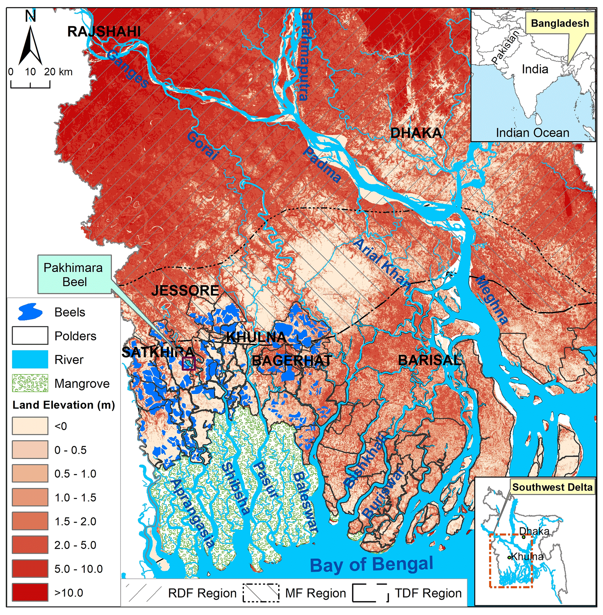
Figure 1Polders and beels of southwestern Bangladesh. Elevation data are from the coastal DEM (Kulp and Strauss, 2018). Beel data are from Adnan et al. (2020).
2.2 General approach
The approach to evaluating the potential of raising the land surface elevation of the beels in southwestern Bangladesh by sedimentation through controlled flooding is presented in Fig. 2 and described in the following sections.
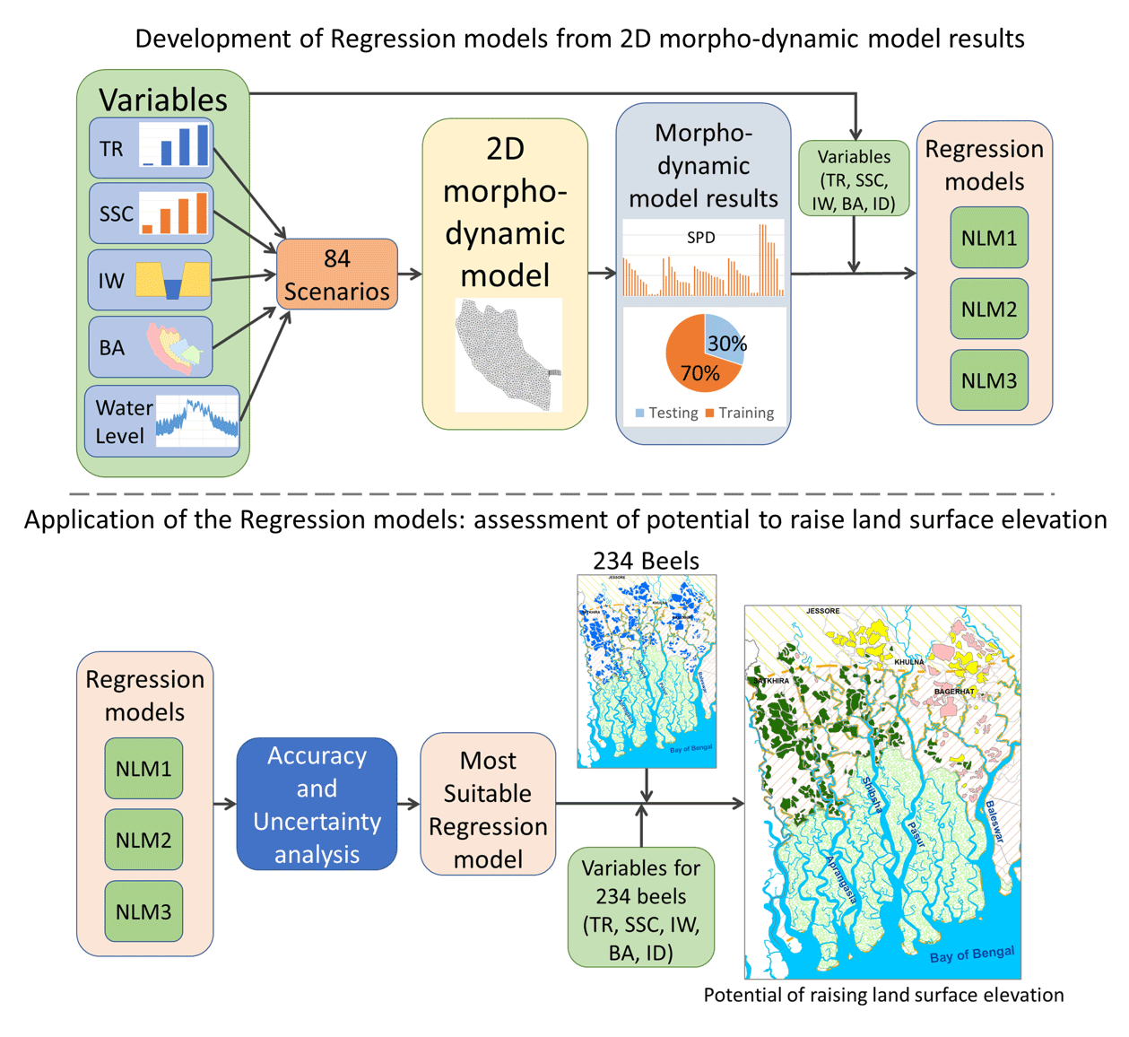
Figure 2General approach used to establish the regression models for sediment deposition from physical control parameters and their subsequent application to estimate potential of raising land surface elevation throughout the southwestern Bangladesh delta.
2.2.1 Beel template for 2D hydro-morphodynamic model simulations
To estimate the total sediment deposition in beels resulting from the TRM operation, we used a two-dimensional (2D) hydro-morphodynamic numerical model that was implemented and calibrated for the Pakhimara Beel by Islam et al. (2020) as a reference. Tidal river management (TRM) has been operational since 2015 in the Pakhimara Beel, and monitoring data on the water level, discharge, and suspended sediment concentration have been collected by Institute of Water Modelling (IWM; IWM, 2017a), which makes it an appropriate reference situation (see Islam et al., 2020). Here, this model was used as a template for beels across southwestern Bangladesh by adapting the surface area of the beel and the boundary conditions to different local conditions that occur within the SW delta. The area of the Pakhimara Beel is about 700 ha, which is comparable to the average surface area of the beel (656 ha), as described by Adnan et al. (2020). Model simulations were carried out, using MIKE 21 FM (flow model) in which hydrodynamic processes and sediment transport are simulated dynamically to account for the hydro-morphological interactions (DHI, 2012a). The three-dimensional incompressible Reynolds-averaged Navier–Stokes equations are solved by MIKE 21 FM (DHI, 2012a). The tool uses an approximate Riemann solver to calculate the convective fluxes at the interface of the cells of the 2D mesh (DHI, 2012a). The mud transport (MT) module uses the advection–dispersion equation (ADE). The ADE is solved using the third-order finite difference scheme, known as the ULTIMATE scheme, which is based on the QUICKEST scheme (DHI, 2012b). For morphological simulation, the bathymetry is updated for each time step according to net sedimentation (DHI, 2012b).
To represent the bathymetry of the Pakhimara Beel, a flexible cell size was used. A finer mesh was opted to represent the canal inside the beel, and a coarser mesh was used for the floodplain to reduce calculation costs (Islam et al., 2020). The surface area of the mesh cells varied from 170.5 to 5000 m2 (Islam et al., 2020). The model of the Pakhimara Beel was supplied by time varying water levels and SSC data. As the grain size of the sediment is fine (less than 63 µm) for the study area (Datta and Subramanian, 1997; IWM, 2010), the MT (mud transport) module of MIKE 21 FM for cohesive sediment transport was used.
Islam et al. (2020) calibrated the 2D hydro-morphodynamic model for the Pakhimara Beel by comparing the observed water level, discharge, and SSC with simulated ones. Manning's coefficient, shear stress, and settling velocity were the primary parameters for calibrating the hydrodynamic and morphodynamic models. Sensitivity analysis of the model was carried out with a varying Manning's coefficient from 0.1 to 0.01 s m, shear stress from 0.01 to 0.1 N m−2, and settling velocity from 0.0001 to 0.001 m s−1. To understand the uncertainty of the model, the coefficient of determination (R2) and the normalized root mean square error (NRMSE) were calculated by comparing the modeled results with the observed data for the different input variables. The best model performance was obtained using a spatial average value of 0.032 s m for the Manning's coefficient, shear stress of 0.08 N m−2, and settling velocity of 0.0005 m s−1. The related R2 for water level, discharge, and sediment concentration were 0.87, 0.88, and 0.84, respectively. The NRMSE (percent) for water level, discharge, and sediment concentration were 9.7, 16.6, and 18.3, respectively (Islam et al., 2020). Islam et al. (2020) also captured the effect of spring and neap tide during different seasons by running simulations for three tidal conditions and time periods of 14 d. For this study, we carried out simulations for a similar period of 14 d and similar parameterizations to capture the full range of tidal cycles for three flow seasons. The resulting sediment deposition in a beel was calculated in tonnes per day.
2.2.2 Scenario matrix for hydro-morphodynamic modeling
We explored the following five parameters which affect the total sediment deposition inside a beel: river tidal range (TR) and river suspended sediment concentration (SSC), which are the two physical controls related to hydrodynamics of the river, and inundation depth (ID), the width of the inlet (IW), and the surface area of the beel (retention basin, BA), which are the three physical controls related to geo-morphodynamics of the beel. We have selected the parameters that are the primary controls of the sediment trapping within a beel. The ID and the TR determine the volume of water and sediment that may enter a beel. The SSC in the river water then linearly determines the sediment load conveyed into the beel. The IW and BA are controls of the actual volumes entering a beel and the residence time of the water, determining the time for sediment settling. We have explored the physical drivers, and the parameters considered take into account geomorphic conditions as well. The variable ID is the difference between the average land elevation and water level; as such, it takes the geomorphic parameters proposed by Adnan et al. (2020), such as land elevation, topographic slope, and curvature of the land, into account. Additionally, two of our proposed parameters, TR and SSC, take water and sediment dynamics of the river into account.
For our analysis, we adjusted the hydro-morphodynamic model of the Pakhimara Beel with different values for the input parameters that represent the physical control variations across the SW delta. A scenario matrix of those boundary conditions was developed, considering varying IW, BA, TR, and SSC. Inundation depth (ID) was determined for each scenario as being the difference between the average land level inside the beel and the average water level from 2D hydro-morphodynamic model results. The land elevation data were obtained from the coastal DEM generated by Kulp and Strauss (2018).
The inlet width (IW) of the beels of previous TRM projects, as reported by Gain et al. (2017), varied from 30 to 60 m. We, therefore, used inlet widths of 30, 60, and 120 m for the scenarios. The study of Adnan et al. (2020) was used to determine a relevant range in surface areas of the beels (Fig. 1). The average area of the beels in southwestern Bangladesh is about 656 ha (Adnan et al., 2020), and 90 % of the beels are smaller than 1400 ha. The beels are located within the catchments of the Pasur, Shibsa, Kobadak, and Kholpetua rivers and their tributaries (Fig. 1). For our scenarios, 230, 460, 700, and 1400 ha were considered as the surface area of the beel.
Tidal range (TR) and SSC vary spatially for different flow regions and seasons. Islam et al. (2021) divided the southwestern delta into three regions based on the flow regime of their rivers, namely river-dominated flow (RDF), mixed river tide flow (MF), and tide-dominated flow (TDF) regimes in the coastal area. Following Islam et al. (2020) and Lázár et al. (2015), we distinguished the following three flow seasons: the dry season (November to February), pre-monsoon season (March to May), and monsoon season (June to October). For all flow regions, TR is highest during the pre-monsoon season and lowest during the monsoon season (Islam et al., 2021). Tidal range is generally higher for the rivers in the TDF region than for the rivers in the RDF region of the southwestern delta. Suspended sediment concentration (SSC) in the river is highest during the monsoon season and lowest during the dry season for the RDF and MF regions. For the TDF region, SSC in the river is highest during the pre-monsoon season and lowest during the dry season (Islam et al., 2021). For the scenarios, we used the TR and the SSC that occur within the three flow regime regions during the different seasons, as defined by Islam et al. (2020, 2021; Table 1). Islam et al. (2021) used sediment rating curves when measured SSC were not available.
To simulate and analyze the effect of different scenarios, the calibrated model of the Pakhimara Beel developed by Islam et al. (2020) was adjusted for different inlet widths and surface areas of the beel (Fig. 3) and for different TR, SSC, and inundation depth, where the last results from the flood water level in the feeding river channel were used. The boundaries of the beels were selected for different scenarios in such a way that the surface area of the beel met the criteria of the scenarios presented in Table 2. It was assumed that the adjusted models represent the sediment dynamics inside the beel as if the beels were located within different parts of the delta. The ground level of the model was adjusted for different regions within the delta following Islam et al. (2021). The average altitude of the RDF region is 5.6 m a.m.s.l., which is higher than the average river water level for pre-monsoon and dry seasons. During the monsoon season, the average water level in the rivers of the RDF region is high enough to flood the land. Therefore, only the monsoon season is considered for the RDF region in the scenario matrix. In total, we developed 84 scenarios considering the seasonality of water level and SSC, different inlet width, and the surface area of the beel (Table 2).
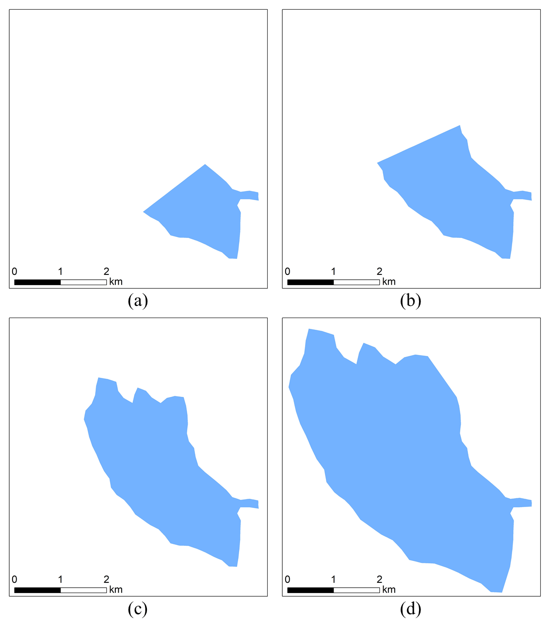
Figure 3The beels with different surface areas considered for scenario development, with (a) 230 ha, (b) 460 ha, (c) 400 ha, and (d) 1400 ha.
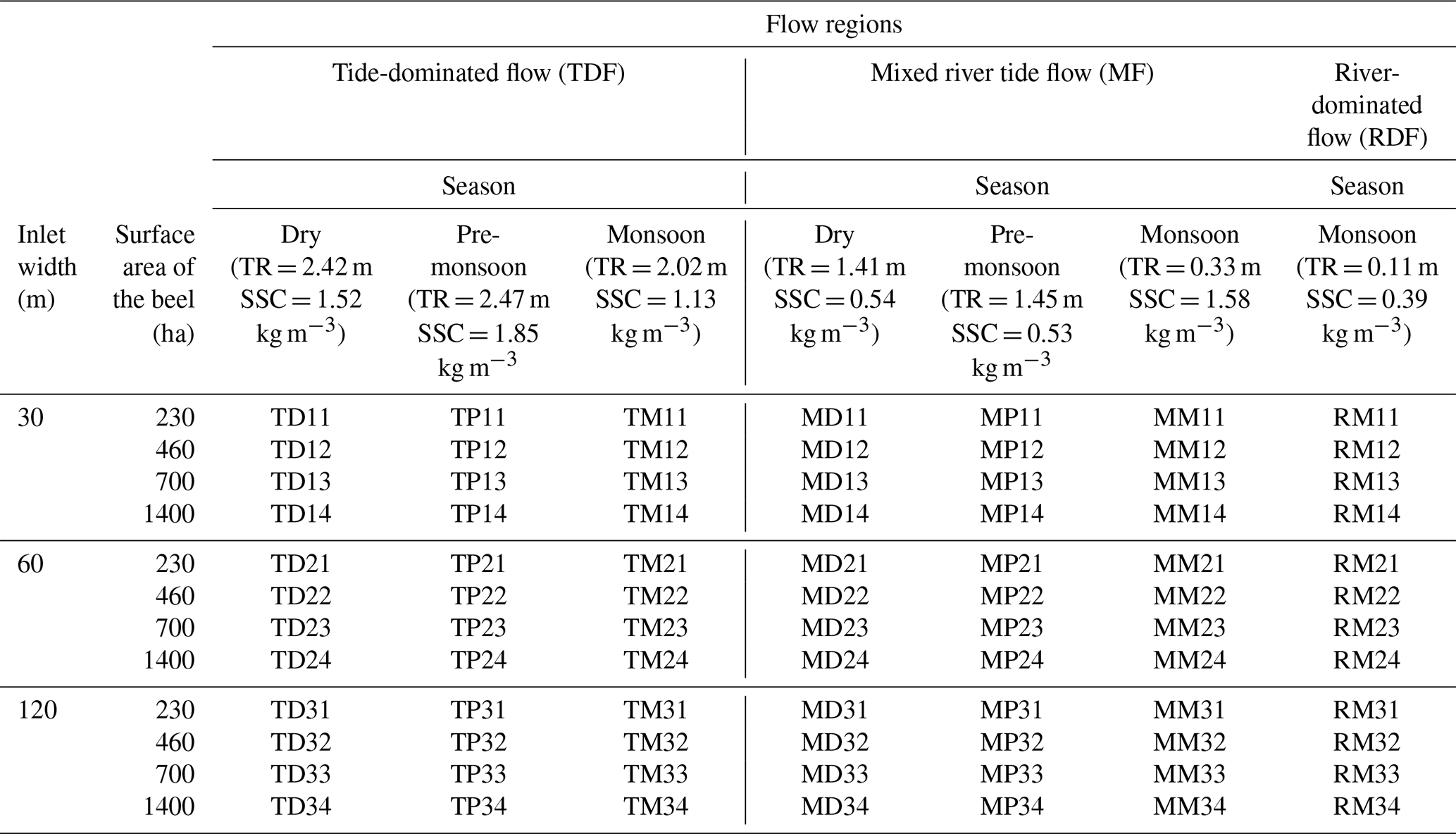
Table 2Scenario matrix, combining beel surface area and inlet width with different flow regimes and seasons. TR is the tidal range, and SSC is the suspended sediment concentration in the feeding river.
2.2.3 Identifying the effect of TR, SSC, ID, IW and BA on sediment deposition
The calculated amounts of sediment deposition per day (SPD) in the beel, using the 2D hydro-morphodynamic model for all scenarios, were compared with each other to determine and understand how these depend on the five parameters studied (TR, SSC, ID, BA, and IW). Using an analysis of variance (ANOVA), we identified which of these five parameters and their interconnectivity significantly correlate to the sediment deposition per day (SPD). A Pearson correlation matrix was calculated to determine the strength of the correlations among the parameters.
2.2.4 Non-linear regression analysis
Previous studies (Islam et al., 2020, 2021; Talchabhadel et al., 2017; Gain et al., 2017) indicated that the relations are non-linear between SPD and TR and between BA and IW. Moreover, linear multivariate regressions (LMs) usually include a residual term, which would predict sediment deposition even when all variables have zero value, such as in the empirical equation used by Adnan et al. (2020). We, therefore, applied a non-linear multivariate regression (NLM) analysis between the beel characteristics (BA and IW), boundary conditions (TR, SSC, and ID), and sediment deposition in the beel (SPD; in tonnes per day) calculated by the hydro-morphodynamic model for these inputs and considered them as variables of NLMs (Fig. 2). The regression equation has the following form as Eq. (1):
where a, b, c, d, e, and f are statistically obtained coefficients.
The results of the model simulations for the 84 scenarios were divided into two groups, where 56 (70 %) of them were used as training set and 28 (30 %) as testing set for the regression analysis (Fig. 2). The regression coefficients were determined from the training set, after the log-transformation of the equation and correction for bias resulting from this transformation. In accordance with the way MIKE 21 FM simulates sediment deposition from suspended sediments, SSC affects sediment deposition linearly (DHI, 2012b). Therefore, the exponent for SSC in the regression analysis was fixed to 1. We calculated the coefficient of determination (R2) and the normalized root mean square error (NRMSE) for different combinations of predictive variables to identify which predictors should be included to estimate sediment deposition per day. To explore the sensitivity of the regression analysis related to dividing the results of the model simulations to training and testing samples, 10 sets of training and testing samples were randomly generated.
2.2.5 Application of the regression model to estimate potential sediment deposition and land surface elevation in the beels of southwestern Bangladesh
The regression model established was applied to estimate the sediment deposition per beel under TRM using IW, BA, ID, average SSC, and average TR for the 234 beels identified by Adnan et al. (2020). For each beel, we first determined the associated flow regime of the feeding river branch (see Islam et al., 2021). To estimate the sediment deposition for the beels using the regression model, we used the TR and SSC for the flow regions and different seasons defined by Islam et al. (2021). Inundation depth (ID) was determined from the difference between the average local land surface elevation and the average water level inside the beel. The surface area (BA) was determined for all beels, and a standard inlet width (IW) of 60 m was used. To estimate the total sediment deposition for each of the 234 beels, sediment deposition per day (SPD) was multiplied for each season by the number of days per season, and the results were summed to obtain the annual deposition. From these estimated seasonal and annual sediment depositions, land elevation increase was calculated using the beel area and sediment dry bulk density of 1300 kg m−3, as suggested by Allison and Kepple (2001) and Rogers and Overeem (2017), for the GBM delta. The estimated land elevation increase was compared with the relative sea level rise (RSLR) per year to define the potential of raising land surface elevation to counteract RSLR. The potential is considered as low, when the land height increase is lower than maximum anticipated RSLR of 10 mm yr−1 for RCP8.5 in 2050, as medium, when the land elevation increment is between 1 and 3 times RSLR, as high, with increments between 3 and 5 times RSLR, and as very high, when elevation increment is more than 5 times RSLR. In the latter case, TRM can potentially be applied to the beel once every 5 years to counteract RSLR.
3.1 Sediment deposition for different beel layouts and boundary conditions
The results obtained by the hydro-morphodynamic models for the different scenarios indicate that the average sediment deposition per day (SPD) varies seasonally and spatially with varying tidal range (TR) and suspended sediment concentration (SSC; Fig. 4). The highest SPD occurs during the monsoon season along river branches with a mixed-flow (MF) regime. During the dry and the pre-monsoon seasons, the highest SPD occurs in the tide-dominated flow (TDF) region. During the dry and pre-monsoon seasons, deposition cannot occur in the river-dominated flow (RDF) region, and even during the monsoon season, the SPD in the RDF region is substantially lower than in the other two regions.
Sediment deposition per day (SPD) generally increases for larger beels, but the increase varies among the regions and seasons (Fig. 4). For the monsoon season, the beels with a surface area (BA) of 1400 ha have 1.5, 5.2, and 5.4 times higher SPD compared to the SPD of 230 ha BA in the TDF, MF, and RDF regions, respectively. For the pre-monsoon season, this ratio is about 2 in the TDF region and about 4 in the MF region. The results of the morphodynamic model also indicate that the inlet width (IW) of the beel has very little effect on SPD (Fig. 4). According to the morphodynamic model results the considered inlet widths are apparently not a limiting factor for deposition; the channel capacity becomes the limiting factor to convey the larger flow of water towards the beel for the wider inlets.
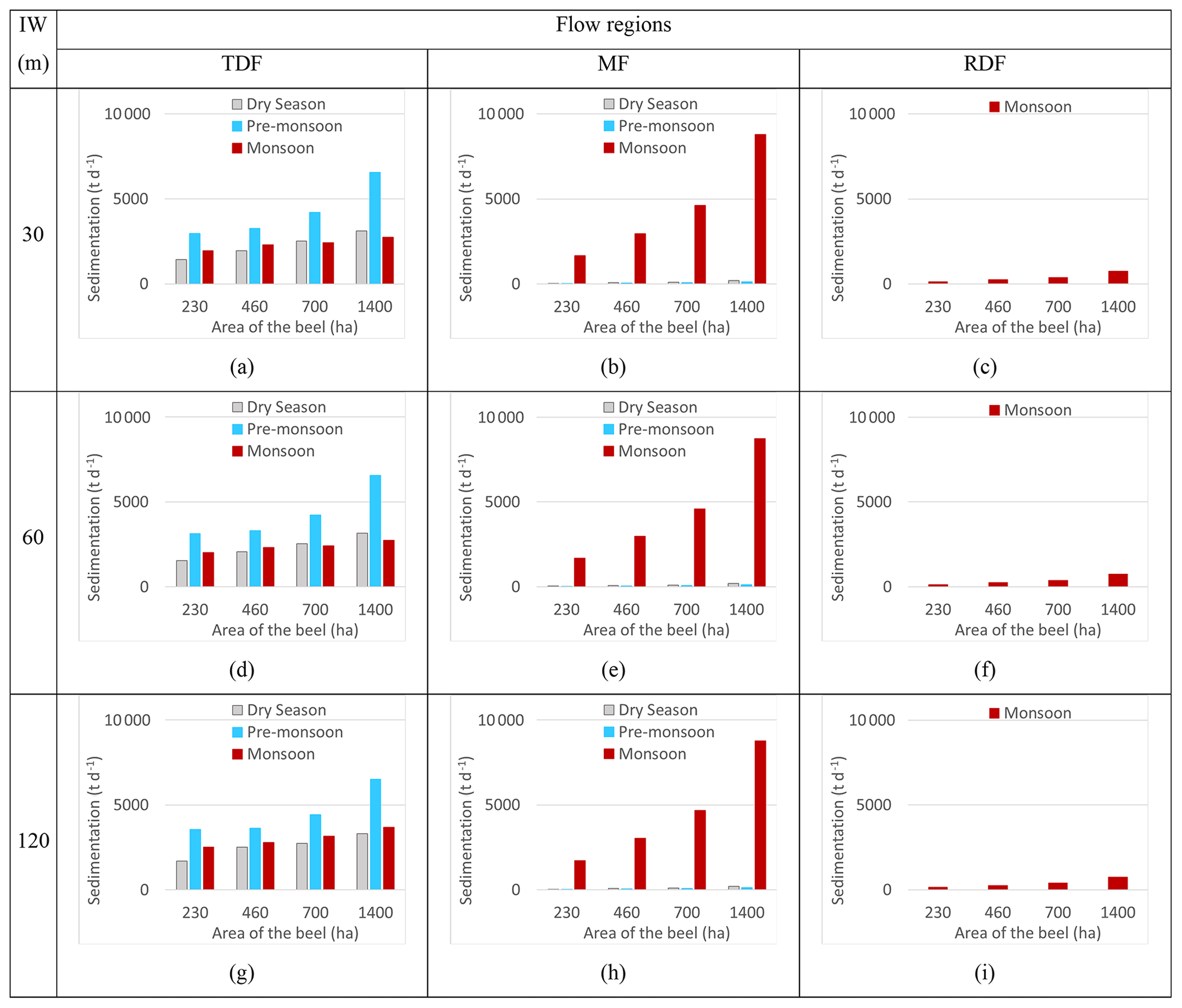
Figure 4Sediment deposition simulated with the 2D hydro-morphodynamic model for three different inlet widths (IW), three different flow regions (TDF – tide dominated flow; MF – mixed flow; RDF – river-dominated flow), four different beel surface areas (BAs), and three different seasons.
With larger tidal range, larger volumes of water and sediment become transported inside the beels. Moreover, the effect of TR on SPD is highest close to the inlet, and the effect decreases when moving away from the inlet. The effect of the tide also decreases further inwards, as those beel sections are much wider and the tidal energy dissipates. For the subareas where the effect of TR is high, especially near the inlet, the flow remains dynamic and active, which results in lower SPD. Furthermore, the velocity inside the beel decreases with increasing distance from the inlet. Therefore, water flow velocities in the distal areas located farthest from the inlet of larger beels are considerably lower than those in the distal parts of smaller beels. Sediment deposition rates increase at lower flow velocity. Combining the effect of having larger volumes of sediment delivered into a beel and lower flow velocities in the distal areas of the beel results in higher sediment trapping efficiency and higher SPD for larger beels (Fig. 4). However, sediment deposition per unit area is generally higher for smaller beels. As TR and SSC govern the sediment load delivered by the river, the seasonality of TR and SSC results in the seasonal and spatial variation in SPD inside the beel. Sediment deposition per day (SPD) is higher when TR and SSC are higher. The velocity and shear stress are higher close to the inlet for narrow inlets, which prevent sedimentation near the inlet. Therefore, suspended sediment tends to settle close to the inlet with increasing inlet width, resulting in a different spatial distribution of the sediment deposition for different IW, even though IW has a minimal effect on SPD.
3.2 Controls of sedimentation
The ANOVA test demonstrated a significant effect of TR, SSC, BA, IW, and ID on modeled SPD (Table 3). Also, most of the interactions between TR, SSC, ID, BA, and IW are significant for SPD as the p value is smaller than 0.05 (Table 3).
Table 3ANOVA test p value for sediment deposition per day (SPD), with tidal range (TR), suspended sediment concentration (SSC), beel surface area (BA), width of the inlet (IW), and inundation depth (ID) and their interaction.
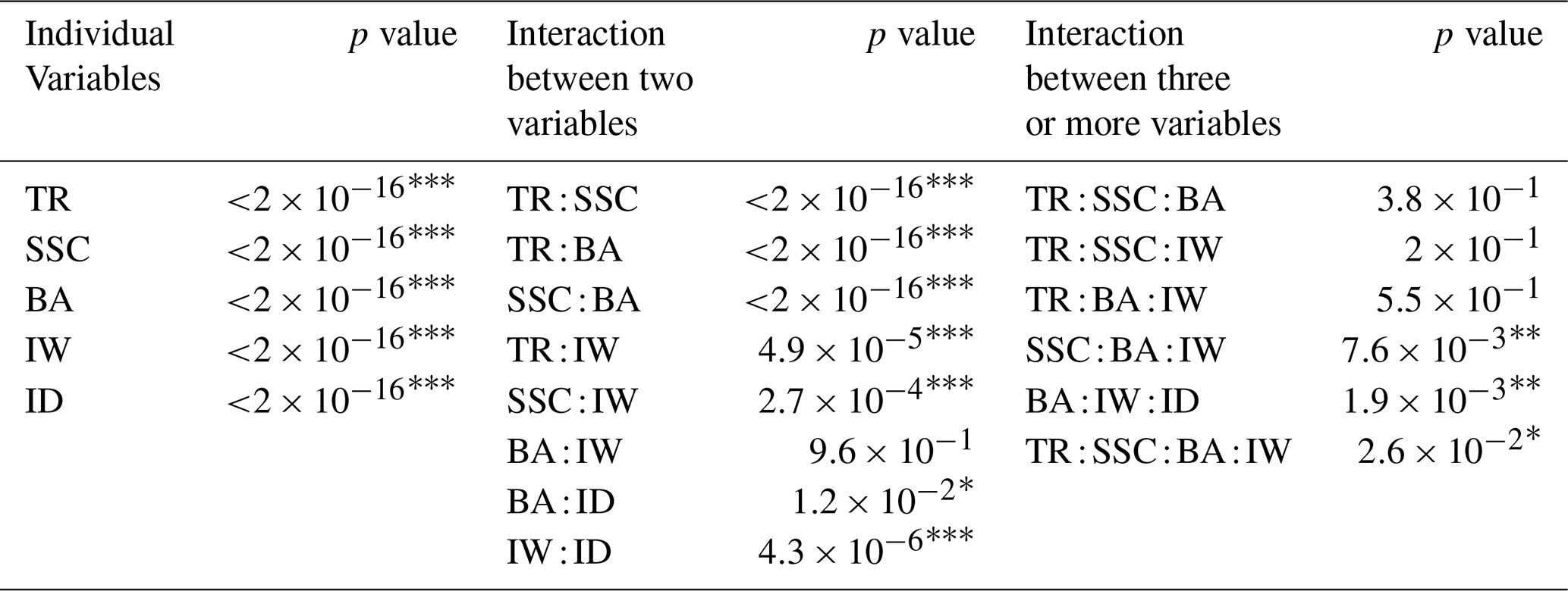
Significance codes are 0, 0.001, * 0.01, 0.05, and 0.1.
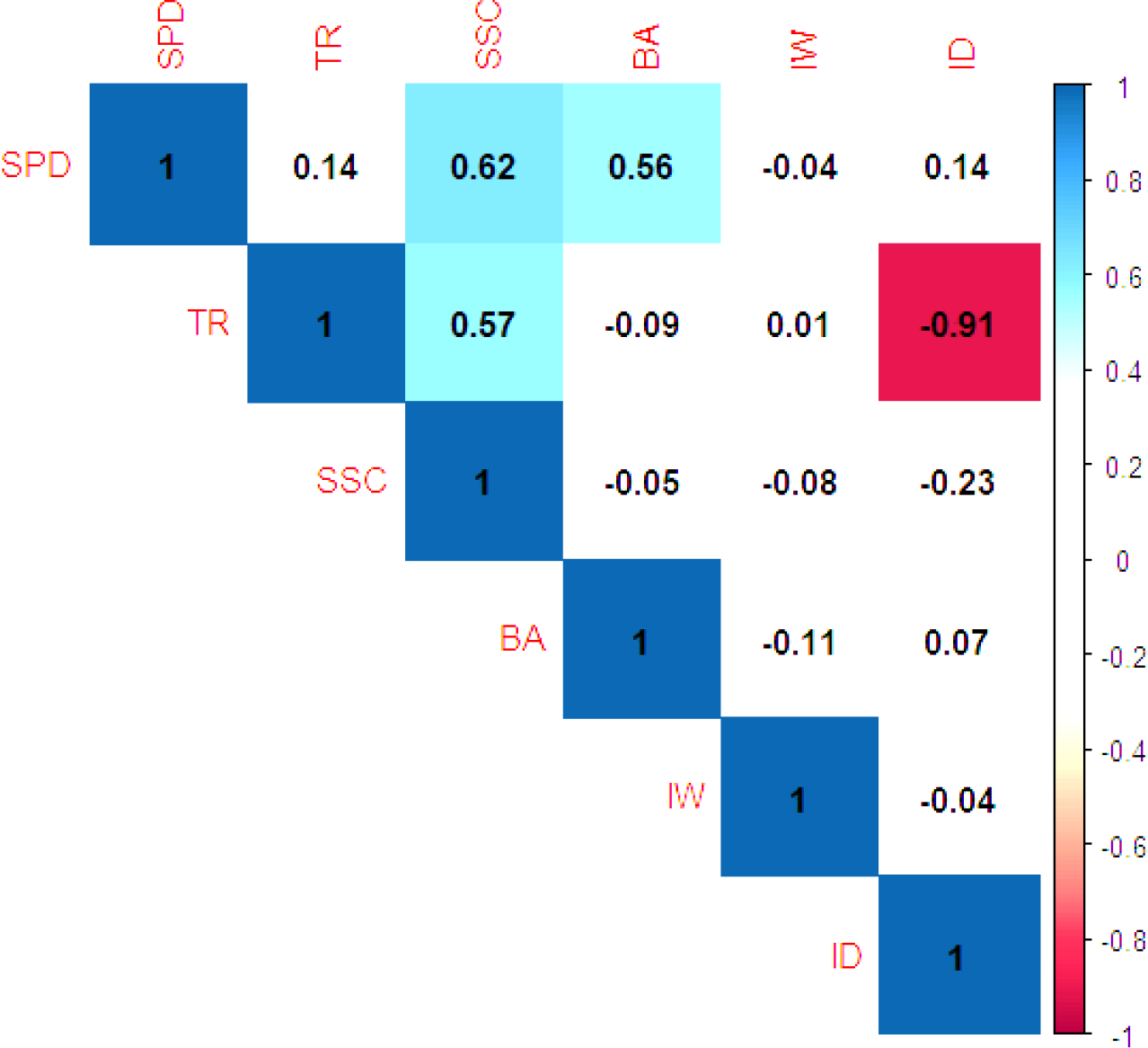
Tidal range (TR), SSC, ID, and BA positively correlate with SPD, with the highest correlations for SSC and BA (Table 4). These correlations reflect the higher TR and SSC in the TDF region (Table 2), resulting in high SPD when compared to the other flow regions (Fig. 4). Conversely, the lowest SPD in the RDF region reflects its lower SSC and TR (Table 2; Fig. 4). The strong correlation of SSC with SPD is evident for the MF region during the monsoon season because SSC is higher in this region than in the TDF region (Fig. 4). TR is higher during the monsoon season in the TDF region than that in the MF region, while SSC is lower (Table 2). Similar to TR and SSC, larger BA and ID result in larger volumes of water and sediment entering a beel and, hence, higher SPD (Fig. 4), which is reflected in their positive correlation with SPD (Table 4). The large ID in the MF region during the monsoon season results in the positive correlation of ID with SPD. The correlation matrix also indicates that TR and ID have a very strong negative correlation (Table 4). Tidal range (TR) is lowest during the monsoon season when water level in the river is highest, and TR is high during the dry and the pre-monsoon season when water level in the river is low (Table 2). This results in the negative correlation between TR and ID. Suspended sediment concentration (SSC) and BA have a stronger effect on SPD as the correlation of SPD with these are highest. Tidal range (TR) and ID have a moderate effect on SPD, and IW has minimal to no effect of SPD.
Table 4Pearson correlation coefficients between sediment deposition per day (SPD), tidal range (TR), suspended sediment concentration (SSC), beel surface area (BA), width of the inlet (IW), and inundation depth (ID).
3.3 Multivariate regression model for prediction of sediment deposition
Based on the correlation between the controlling factors and SPD, as well as the significance of the controlling factors for SPD (Tables 3 and 4), we set up a multivariate regression model to estimate SPD. Sediment deposition per day (SPD) has a strong to moderate positive correlation with SSC, BA, TR, and ID and a weak negative correlation with IW (Table 4). Although IW has a minimal effect on SPD, IW is found as statistically significant for SPD (Table 3). The interconnectivities between TR, SSC, ID, and BA are also identified as statistically significant for SPD (Table 3). Therefore, we considered all the control factors (TR, SSC, ID, BA, and IW) as variables for the regression analysis to estimate SPD and compared the results to identify the most suitable empirical equation for the regression model.
Since the interconnectivities between TR, SSC, ID, and BA are significant for SPD (Table 3), and since the effect of TR and BA on SPD is non-linear (Fig. 4), we developed three non-linear multivariate regressions (NLMs) with an increasing number of variables. Suspended sediment concentration (SSC) and BA were considered as variables for NLM1, as SSC and BA have higher correlation with SPD (Table 4). Tidal range (TR) and ID were included as variables along with SSC and BA for NLM2, as TR and ID have a moderate correlation with SPD (Table 4). All the variables, SSC, BA, TR, ID, and IW, were included in NLM3. The range and standard deviation (SD) of the parameters of the NLMs for 10 sets of training and testing sample are presented in Table 5. Note that the exponential coefficient for the suspended sediment concentration was fixed to 1. The variation in the regression coefficients obtained using the different training sets is generally low, with a higher variation for the scaling factor a and the exponential coefficient f related to IW.
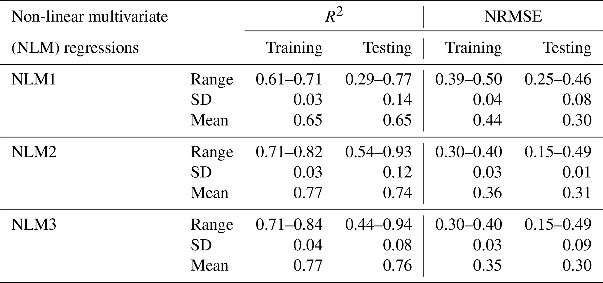
Figure 5 shows the estimated SPD by MIKE 21 FM models versus the calculated SPD by regression models for both the training and testing datasets. NLM1 shows a larger spread and seems to overestimate SPD for low and higher values when compared to the other two regression models. The coefficient of determination (R2) of the three regression models ranges between 0.61 and 0.84, for the training sets, and between 0.29 and 0.94, for the testing sets (Table 6). The averages for the two sets are, however, highly comparable. The predictive skill of the models generally increases with increasing number of variables. NLM1, using only BA and SSC as predictors for SPD, results in relatively moderate average R2 of 0.61 and 0.71 for the training and testing data sets, respectively (Table 6). NLM2, using TR, SSC, ID, and BA, and NLM3, using TR, SSC, ID, BA, and IW, produce better results. The mean R2 values for NLM2 are 0.77 and 0.74 for training and testing datasets, respectively, and the mean R2 values for NLM3 are 0.77 and 0.76 for training and testing datasets, respectively (Table 6). Although IW has a statistically significant correlation with SPD in the ANOVA test (Table 3), it hardly contributes to better prediction of SPD with exponential coefficients of 0.02–0.14 (Table 5). The normalized root mean square error (NRMSE) ranged between 0.3 and 0.5, for the training datasets, and between 0.15 and 0.49, for the testing datasets (Table 6). The mean of NRMSE for NLM1 for the training samples is higher than obtained for NLM2 and NLM3. The mean NRMSE obtained for the testing dataset is almost similar for all three NLMs.
Since NLM3 yielded the highest mean R2 and the lowest mean NRMSE for both the training and testing dataset (Table 6), it was selected as being the most suitable regression model to estimate SPD for the beels of southwestern Bangladesh. As a separate test, we applied NLM3 to the Bhaina Beel and the Khuksia Beel, where TRM was operated previously. Van Minnen (2013) reported that 6.45×10⁶ and 8.2×10⁶ m3 of sediment were deposited in Bhaina Beel and Khuksia Beel, respectively, after 5 years of TRM operation. Sediment deposition per day (SPD), estimated with the NLM3 regression models for Bhaina Beel and Khuksia Beel, had an average error of about 12 %–17 % relative to the observed value, which can be considered as moderate. This supported our confidence that the regression model NLM3 can be applied as a simple regression model for evaluating TRM potential on the basis of the estimated sediment deposition in beels in the southwestern GBM delta.
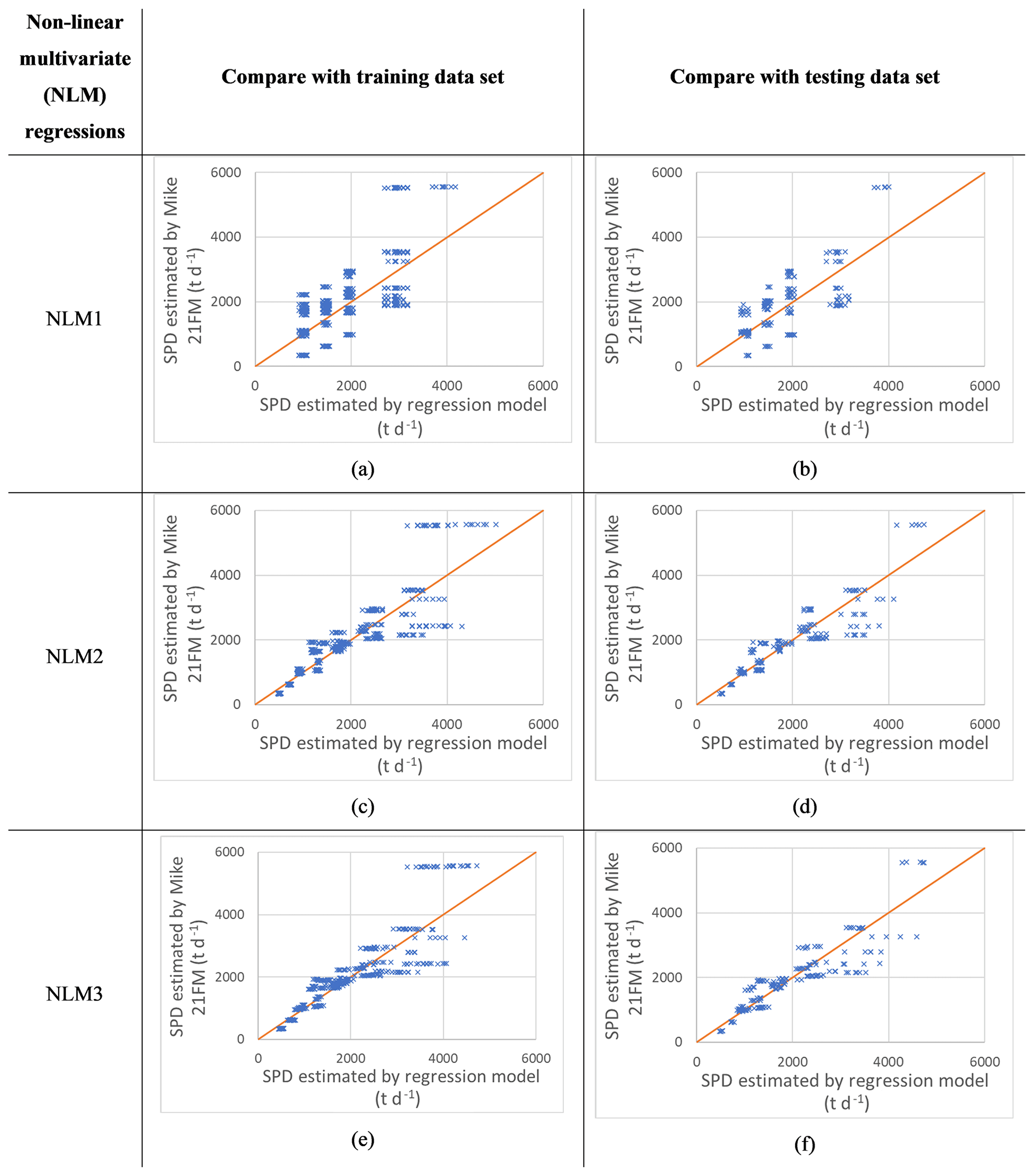
Figure 5Comparing the values for SPD, calculated from the hydro-morphological model results against the values for SPD, estimated with the NLM regressions, for all 10 sets of training and testing data samples. The line depicts the 1:1 line.
Table 5The range and standard deviation (SD) of the parameters of NLMs. Note that exponent b was fixed to 1.
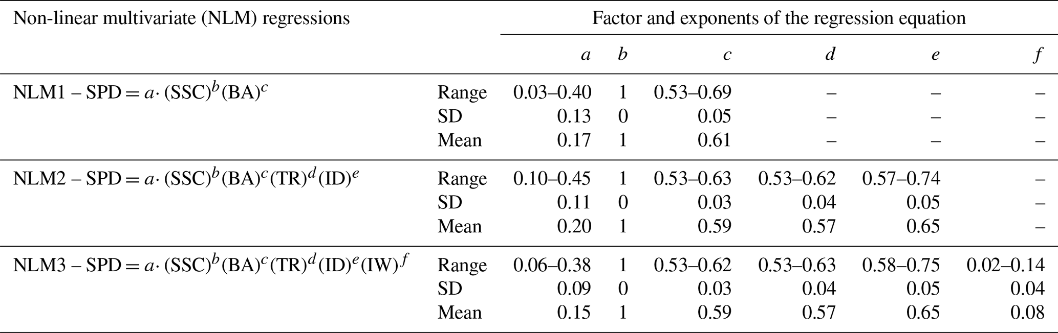
Table 6The accuracy and sensitivity of the non-linear multivariate (NLM) regressions with different variables.
3.4 Estimation of the potential of the beels to stay above sea level through renewed sedimentation using the regression model
The potential of sediment deposition to raise the land surface of the beels of southwestern Bangladesh was assessed using the empirical equation of the NLM3 regression model, assuming a beel inlet width of 60 m for all cases. The estimated potential of raising the land surface elevation shows considerable seasonal and spatial variability (Fig. 6). Seasonal estimated SPD for all beels varies from 4 mm yr−1 (0.4 times RSLR) during the dry season to 150 mm yr−1 (15 times RSLR) during the monsoon season. Spatially, the beels located west of the Pasur River of the study area have a high potential for TRM for all scenarios, while the beels east of the Pasur River generally have lower potential (Fig. 6). Generally, smaller beels have higher potential to raise the land surface elevation than larger beels (Fig. 6). Out of the 234 beels, 32, 31, and 35 have a high potential and 115, 120, and 187 have a very high potential to raise the land surface elevation during the dry season, pre-monsoon season, and monsoon season, respectively. This means TRM operation during the monsoon season only is sufficient to raise the land surface by more than 3 times the yearly RSLR (>30 mm yr−1) for 96 % of all beels and by more than 5 times the RSLR (>50 mm yr−1) for 80 % of all beels. Applying TRM throughout the year increases the potential to raise the land surface elevation from high to very high in 22 additional beels.
A number of beels located east of the Pasur River still have a low to medium potential, even with the year-round operation of TRM. The beels within the MF region have a low to medium potential to raise the land surface elevation when TRM is operated during the dry and pre-monsoon seasons (Fig. 6a and b).
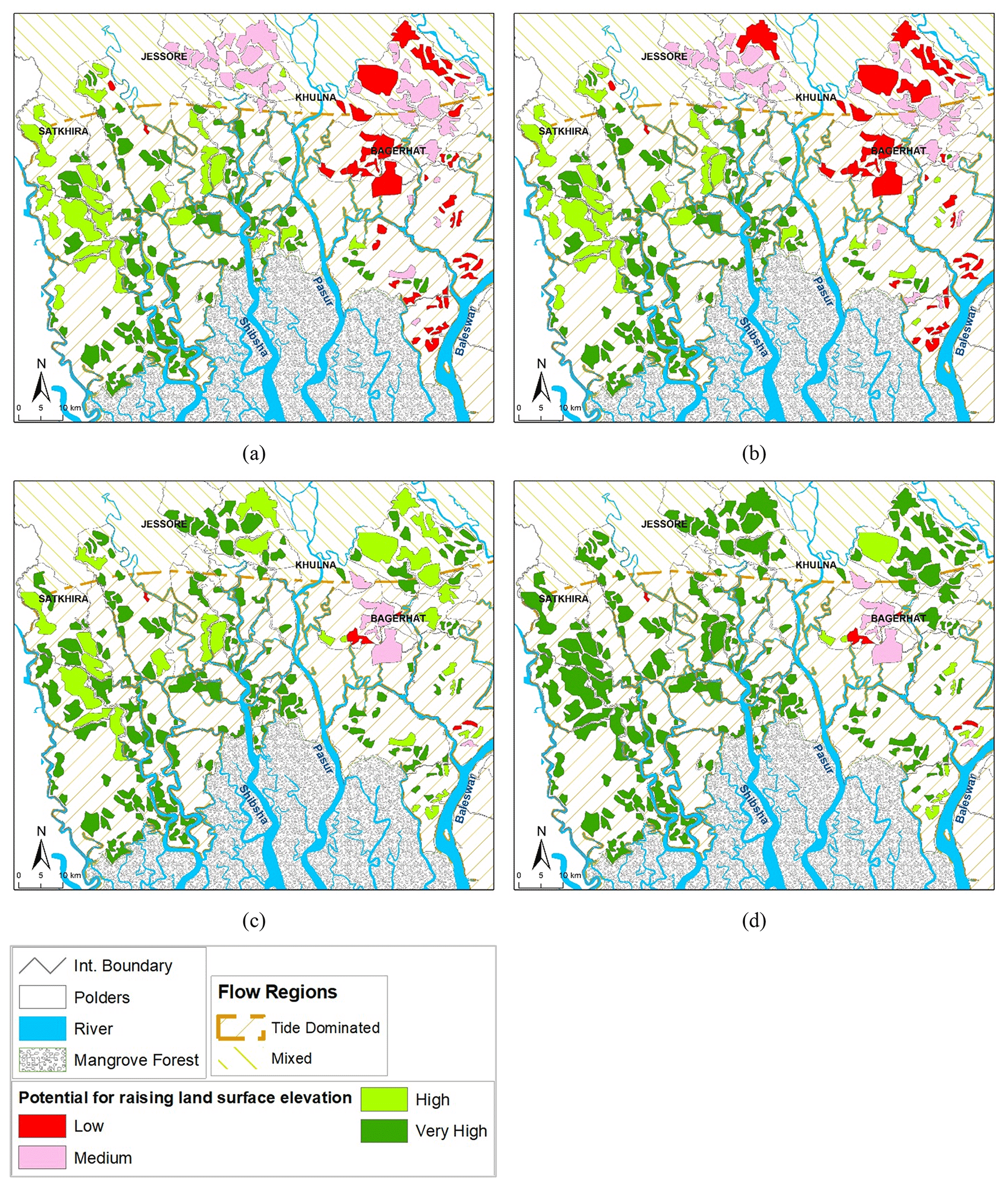
Figure 6The potential of raising the land surface elevation of beels in southwestern Bangladesh using TRM operation during (a) dry, (b) pre-monsoon, and (c) monsoon seasons and (d) throughout the year. Very high potential is >5 times RSLR; high is 3–5 times RSLR; medium is 1–3 times RSLR; low potential is <1 times RSLR (RSLR = 10 mm yr−1).
4.1 The effect of physical controls on sediment deposition per day (SPD)
We explored how sediment deposition per day (SPD) in beels having a single inlet under the active operation of tidal river management (TRM) depends on boundary conditions associated with the flow regime of the feeding river and season (tidal range – TR; suspended sediment concentration – SSC) and on various beel dimensions (surface area – BA; width of the inlet channel – IW; inundation depth ID).
The physical controls TR and SSC, which are related to the hydrodynamics of the river, have a positive correlation with SPD. SPD depends on the sediment load in the feeding rivers for which TR and SSC are primary drivers, resulting in a positive correlation of SPD with TR and SSC (Table 4). This is similar to the findings of Islam et al. (2020, 2021). Of the two physical controls, TR and SSC, SSC has the highest correlation with SPD (Table 4). This means that the sediment deposition in beels depends mostly on SSC in the feeding river, which, in turn, shows a high correlation with TR (0.57). The physical controls TR and SSC are deemed statistically significant by the ANOVA test p values (Table 3). Islam et al. (2021) found that the seasonal and spatial variation in SSC and TR in the rivers result in a large seasonal and spatial variation in the sediment deposition in beels, indicating that TR and SSC are primary physical controls of SPD. The scientific document provided by the DHI (Danish Hydraulic Institute) for MIKE 21 FM indicates that SPD increases linearly with increasing SSC (DHI, 2012b). Talchabhadel et al. (2017) indicated that high sediment deposition occurs inside the beel with a stronger tide in the river. According to Talchabhadel et al. (2017) and DHI (2012b), SPD will vary seasonally with seasonality for SSC and TR, which is confirmed by our findings.
A statistical analysis of our 2D hydro-morphodynamic model results indicates that, among the physical controls BA, ID, and IW, which are related to geo-morphodynamics of the beels, SPD has highest correlation coefficient with BA (0.56; Table 4). SPD increases with a larger beel surface area, which is in accordance with Van Minnen (2013), who reported that 6.45×10⁶ m3 of sediment was deposited in the Bhaina Beel (600 ha) compared to 8.2×10⁶ m3 in the larger Khuksia Beel (1100 ha) during 4 years of TRM operation. With a larger surface area of a beel, a larger volume of suspended sediment can be delivered inside. We found that SPD has positive correlation with ID and BA (Table 4), which is similar to Talchabhadel et al. (2017), who indicated that more sediment deposition occurs when larger volumes of water enter the beel with tide. We found low correlation between IW and SPD (Table 4), which is consistent with the findings of Talchabhadel et al. (2017). They suggested that IW has a minimal effect on SPD, although the spatial distribution of the sediment deposition varies between different IWs, which is similar to the results of our 2D hydro-morphodynamic model. As BA and ID vary among the beels of southwestern Bangladesh, this causes variations in SPD among the beels. All three physical controls related to geo-morphodynamics of the beels, BA, ID, and IW, and their interactions are statistically significant for SPD, as indicated by the ANOVA test p values (Table 3).
4.2 Estimation of SPD with multivariate non-linear regression models (NLMs)
We developed non-linear regression models from the 2D morphodynamic model results to provide an a priori estimation of the sediment deposition inside the beels of southwestern Bangladesh if they were subjected to TRM practice. Adnan et al. (2020) used linear regression modeling with geomorphological parameters as variables, which were mostly related to the land elevation, to calculate sediment deposition. They did not consider TR and SSC to estimate the sediment deposition, but Islam et al. (2020) found that sedimentation inside the beel depends strongly on the SSC and TR in the rivers. The coefficient of determination (R2) of the linear regression model of Adnan et al. (2020) is stated as 0.88, even though their empirical equation had a residual which will yield sediment deposition with all the variables set to zero. We used non-linear regression models to include the effects of non-linearity between SPD and the steering physical factors, TR, BA, ID, and IW and their interaction, as described by Islam et al. (2020), Talchabhadel et al. (2017), Gain et al. (2017), Van Minnen (2013), and DHI (2012b). The accuracy and uncertainty analysis of our regression models for 10 sets of training and testing samples indicate that the regression model NLM3 may be applied to estimate the sediment deposition.
Of the parameters considered in the non-linear regression models as variables, SSC is the most difficult one to have measured data across time and space, and hence, it has large uncertainty. Tidal range (TR) and ID also vary in time and space and are estimated from the observed water level, which has a lower uncertainty compared to SSC. The width of the inlet (IW) and BA are related to the geographic setting of the beels and have well-defined values when a TRM is operated. Therefore, SSC has the largest uncertainty while it is a major parameter with the highest correlation with SPD.
4.3 Estimated sediment deposition, potential to raise land surface elevation, and implication for the beels of southwestern GBM delta
Our estimation of the potential sediment deposition and associated land surface elevation increment inside beels using the regression models indicates that TRM shows a high potential to counterbalance RSLR in southwestern Bangladesh. When operated year-round, in 228 out of 234 beels (97 %), the land surface elevation can be raised by more than 3 times the RSLR, as predicted under the RCP8.5 scenario (10 mm yr−1) for southwestern Bangladesh (Oppenheimer et al., 2019). When operated only during the monsoon season, the land surface elevation can be raised in 96 % of all beels by more than 3 times RSLR and in 80 % of all beels by more than 5 times RSLR, indicating that TRM operation only during the monsoon season is almost as effective as a year-round operation.
The sediment carried by the Ganges, Brahmaputra, and Meghna rivers discharges through the Meghna estuary (Anisul and Munsur, 2016). These sediments re-enter the western sea arms, where the beels identified by Adnan et al. (2020) are located due to the clockwise estuarine circulation (Anisul and Munsur, 2016). Derby et al. (2018) indicated that, due to anthropogenic and climate change, the supply of fluvial sediment to the apex of the GBM delta is likely to increase substantially, by around 50 %, by the 2090s. In contrast, Higgins et al. (2018) projected that, due to anthropogenic changes upstream, both the Ganges and the Brahmaputra rivers will experience a reduction in the annual suspended sediment load by 39 %–75 % and 9 %–25 %, respectively. The increase or decrease in sediment supply in the rivers will impact the potential of the beels for sediment deposition in the future. The overall effect is dependent on the future climate and connected socioeconomic scenarios. With our method, a priori estimation of the sediment deposition and potential of TRM can be achieved for different future scenarios.
Beels close to the sea and to the west of the Pasur River in the tide-dominated flow region show the highest potential for sediment deposition and raising their land surface elevation by means of TRM. However, Adnan et al. (2020) indicated that the beels close to the sea have a low potential to reduce flood susceptibility. The tidal range (TR) and SSC are high in the rivers close to the sea throughout the year (Islam et al. 2021), resulting in a high potential to raise the land surface elevation with sediment deposition for the beels of southwestern Bangladesh. Thus, our results indicate the natural flood vulnerability of these polders may be sustainably reduced by application of TRM using controlled flooding.
According to our estimation, smaller beels generally have a higher potential to raise the land surface elevation than larger beels. Van Minnen (2013) reported that 6.45×10⁶ and 8.2×10⁶ m3 of sediment was deposited in the Bhaina and Khuksia beels during TRM operation, with surface areas of 600 and 1100 ha, respectively (Gain et al., 2017). Although the surface area of the Khuksia Beel was 1.8 times that of the Bhaina Beel, sediment deposition was only 1.3 times higher. Therefore, the average land elevation increment was higher in the smaller Bhaina Beel, which is in line with our findings. As suggested by Amir et al. (2019), the rise in the land surface elevation in larger beels may be achieved by compartmentalizing the beel into smaller part.
The land elevation east of the Pasur River is higher (Fig. 1), resulting in lower ID for beels, even within the same flow regions. Suspended sediment concentration (SSC) and TR are generally lower for the mixed-flow (MF) region when compared to the TDF region during the dry and pre-monsoon seasons (Islam et al., 2021). Therefore, SPD and the potential to raise the land surface elevation with sediment deposition are also generally lower for beels in the MF region during the dry and pre-monsoon seasons when TR and SSC for the river stretches in the MF region are lowest. However, the water level in the rivers is generally higher during the monsoon season (Islam et al., 2021), increasing the ID and, consequently, the SPD, and the potential to raise the land surface elevation is high for almost all the beels. The beels with a low to medium potential to raise the land surface elevation during the monsoon season and annual operation of TRM have a high average land level (Fig. 1), reducing the ID and causing low SPD.
Adnan et al. (2020), Amir and Khan (2019), and Talchabhadel et al. (2018) considered the uninterrupted operation of TRM for several years. In addition to the annual operation of TRM, we have considered the seasonal operation of TRM as well. Our analysis shows that the potential is higher when TRM is operated during the monsoon season than during pre-monsoon and dry seasons (Fig. 6). The monsoon season is longer, and sediment load is higher in the rivers, compared to the pre-monsoon and dry seasons, resulting in a higher sediment deposition and a higher potential to raise the land surface elevation than in other seasons. This is an important finding, as the continuous and lengthy operation of TRM may not be accepted by local communities. Farmers living in the Khuksia Beel, where TRM was operated continuously for 7 years, have a negative impression of TRM due to such a long period of operation and a lack of compensation and have questioned its effectiveness (Gain et al., 2017). When TRM is only operated in the monsoon season, the land inside the beel will remain available to local stakeholders for the rest of the year. This may potentially increase the acceptability of TRM to the local stakeholders.
4.4 Using tidal river management (TRM) as a way to keep up with relative sea level rise (RSLR)
Controlled flooding like TRM can potentially be applied, in a rotation, to the beels, with a high potential to counteract the yearly RSLR through sediment deposition and, thus, raise the coastal areas of the GBM delta. This would entail two main phases. First, the land surface in the beels, and the polders they are in, should be raised to make it equal to the current average sea level of the region. After that, TRM should be applied such that the land surface is raised at least at the pace of RSLR to remain equal to or above the sea level. TRM may be operated once every few years to achieve these goals and keep the land available for agriculture in between. Gain et al. (2017) indicated that the rotational operation of TRM has been suggested by experts and local communities. Talchabhadel et al. (2020) explored the rotation of TRM in four beels of southwestern Bangladesh and concluded that TRM can be applied sequentially in one beel at once and continuously for 4 years. They also suggested that TRM should initially be applied in beels located downstream and then gradually shift towards the beels located upstream, regardless of the surface area of the beels. IWM (2017a) also proposed sequential operation of TRM in the beels along the Teka–Hari–Teligati river system of southwestern Bangladesh, where TRM can be applied in one beel at once and continuously for 7 years in each beel. However, physical constraints and socioeconomic aspects of TRM operation should be considered to determine an optimum flood rotation scheme for the beels in southwestern Bangladesh. At this point in time, however, there is no master plan indicating how a rotational scheme should be devised to raise the GBM delta effectively with TRM against RSLR.
Our study may present a method to work out such a plan in future to raise the land with sedimentation and to offset yearly RSLR. However, it must be noted that, in our study, only the total sedimentation inside the beel was explored, and the spatial distribution of sediment deposition was not considered. As Islam et al. (2020), Talchabhadel et al. (2017), and Gain et al. (2017) indicated, the spatial distribution of sediments inside the beel is also important for the operation of TRM. For this, more location-specific, detailed studies will be required to understand the effect of TRM inside a specific beel. The implementation of several previous TRM operations included the excavation of the adjacent river supplying sediments inside the beel (IWM, 2017a, b). Water and sediment dynamics of the river are affected by the change in river bathymetry. Therefore, the effect of dredging and excavation of the river should be explored in the future.
Socioeconomic aspects, such as conflict between the stakeholders, lack of proper compensation, lack of livelihood opportunities, lack of stakeholders' participation during the planning and implementation phase of the TRM, lack of cooperation between stakeholders and government agencies, divergence in common interest, imbalance between the expectation and outcome, and unequal distribution of benefits of TRM, challenged the effective implementation of previous TRM operations (van Minnen, 2013; van Staveren et al., 2017; Gain et al., 2017; Mutahara et al., 2018). Therefore, next to the physical considerations, the socioeconomic aspects and social acceptability of TRM should receive ample attention in order to fully reap the potential of the method we have explored.
To understand how the sediments delivered by the tide inside the beels affect the soil fertility and food productivity, De Bruin (2019) collected samples of new and old sediment deposits from three different locations. The locations were the beel where TRM had been operated in the past (Khuksia Beel), the beel where TRM operation was ongoing (Pakhimara Beel), and an area which received much sediment during a dike breach as a result of a cyclone-induced storm surge (polder 32). Sediment samples were also collected from the areas which are protected from tidal flooding. The rice variety preferred by local farmers was cultivated by De Bruin (2019) in the collected sediment samples, following traditional and local practices. The results indicate that the sediments delivered by tide had similar fertility and food productivity as the old sediment deposits which had not been flooded in recent years. Therefore, the sediments delivered by the rivers of southwestern Bangladesh are as good as the old sediment deposits – if not better.
Our study also considers operation of TRM in one beel within a river reach at once. More detailed studies will be required to reflect on the changes in sediment availability in the river section during a basin-wide operation and the shifting of TRM in several beels, as suggested by Talchabhadel et al. (2016, 2020). As our study considers the TR and SSC of the river sections, the changes in sediment availability for such TRM operation can be taken into account. Moreover, similar to our study, Talchabhadel et al. (2016, 2020) also explored the shifting of TRM operation, considering the TRM in one beel at once.
The Ganges–Brahmaputra–Meghna delta in Bangladesh is severely threatened by the rising sea level. Tidal river management (TRM) may offer a solution by raising the land surface in polders through re-sedimentation by controlled river flooding, using a deliberate dike breach. Previous studies, such as that by Adnan et al. (2020), determined the potential of TRM to raise the land in 234 beels in southwestern Bangladesh, using five geomorphological parameters, and identified 106 beels (26 %) as being suitable for TRM operation but did not take into account the seasonal and spatial variations in physical drivers, the non-linear character of physical drivers, and several sensitive parameters for sediment deposition. We used non-linear multivariate regression models (NLMs) with five parameters as variables to determine the sediment deposition potential of TRM operation in the 234 beels in southwestern Bangladesh, of which tidal range (TR) and suspended sediment concentration (SSC) are related to the hydrodynamics of the river and inundation depth (ID), width of the inlet (IW), and surface area of the beel (BA) are related to the geo-morphodynamics of the beel.
In contrast to Adnan et al. (2020), who considered geomorphological parameters to determine suitability for TRM operation, our NLM results indicate that beels located closer to the sea, where tide dominates river flow, have a higher potential for TRM. Furthermore, the potential to raise land surface elevation using TRM is high (elevation rise >3 times yearly RSLR) for 97 % of the beels with a year-round operation of TRM but almost as effective (96 % of all beels) when operated only during the monsoon season (Fig. 6). In total, 80 % of all beels have very high potential (elevation rise > 5 times RSLR) when operated only during the monsoon season. Smaller beels show a higher potential to raise the land surface elevation than larger beels. Higher land surface increments in larger beels may be achieved by compartmentalizing them into smaller compartments. The fact that TRM operation during the monsoon season shows virtually the same high potential as year-round operation is an important finding, since restricting TRM to the monsoon season implies that the land will remain available for agriculture during the rest of the year. This may increase the acceptability of TRM to stakeholders in the beels and polders.
Our regression model provides a priori estimation of the potential to raise the land surface elevation for the beels in southwestern Bangladesh, which may assist decision-makers in prioritizing the location of TRM operation, for example, as part of the Bangladesh Delta Plan 2100. TRM may be implemented, restricted to monsoon periods, and involve a flood rotation scheme of different polders being raised during different years, over a prolonged period of time, to keep up with continuing sea level rise. However, since TRM operation is not only dependent on physical constraints, planning should also give adequate attention to socioeconomic aspects to gain acceptance by the stakeholders affected.
The data used in this research were provided by the Institute of Water Modelling (IWM) for research purposes only. IWM is the owner of the data. Therefore, the authors do not have the authority to share the data publicly.
All the authors contributed to the conceptualization, development of the methodology, and the writing and editing of the paper. In addition to these, MFI carried out the model simulation and analysis, and PPS, SCD, JG and HM supervised the research.
The contact author has declared that neither they nor their co-authors have any competing interests.
Publisher's note: Copernicus Publications remains neutral with regard to jurisdictional claims in published maps and institutional affiliations.
This research is part of the project “Living polders”, which is funded by the Dutch Research Council (NWO) within the framework of the Urbanizing Deltas of the World program (grant no. W 07.69.201). The authors acknowledge IWM, for sharing data, and DHI, for providing the license for the MIKE 21 tool that was used to conduct this research.
This research has been supported by the Nederlandse Organisatie voor Wetenschappelijk Onderzoek (grant no. W 07.69.201).
This paper was edited by Louise Slater and reviewed by two anonymous referees.
Allison, M. and Kepple, E.: Modern sediment supply to the lower delta plain of the Ganges-Brahmaputra River in Bangladesh, GeoMarine Letters, 21, 66–74, https://doi.org/10.1007/s003670100069, 2001.
Adnan, M. S. G., Talchabhadel, R., Nakagawa, H., and Hall, J. W.: The potential of tidal river management for flood alleviation in south western Bangladesh, Sci. Total Environ., 731, 138747, https://doi.org/10.1016/j.scitotenv.2020.138747, 2020.
Amir, M. S. I. I. and Khan, M. S. A.: An Innovative Technique of Tidal River Sediment Management to Solve the Waterlogging Problem, Coast. Manage., 165–199, https://doi.org/10.1016/B978-0-12-810473-6.00011-X, 2019.
Anisul, H. and Munsur, R.: Flow distribution and sediment transport mechanism in the estuarine systems of Ganges-Brahmaputra-Meghna delta, International Journal of Environmental Science and Development, 7, 22–30, https://doi.org/10.7763/ijesd.2016.v7.735, 2016.
Auerbach, L. W., Goodbred Jr., S. L., Mondal, D. R., Wilson, C. A., Ahmed, K. R., Roy, K., Steckler, M. S., Small, C., Gilligan, J. M., and Ackerly, B. A.: Flood risk of natural and embanked landscapes on the Ganges–Brahmaputra tidal delta plain, Nat. Clim. Change, 5, 153–157, https://doi.org/10.1038/nclimate2472, 2014.
Brown, S., Nicholls, R. J., Lázár, A. N., Hornby, D. D., Hill, C., Hazra, S., Appeaning Addo, K., Haque, A., Caesar, J., and Tompkins, E. L.: What are the implications of sea-level rise for a 1.5, 2 and 3 ∘C rise in global mean temperatures in the Ganges-Brahmaputra-Meghna and other vulnerable deltas?, Reg. Environ. Change, 18, 1829–1842, 2018.
Chakraborty, T. R.: Management of haors, baors, and beels in Bangladesh: Lessons for lake basin management, IUCN Bangladesh Country Office, Dhaka, Bangladesh, 1–15, 2006.
Darby, S. E., Dunn, F. E., Nicholls, R. J., Rahman, M., and Riddy, L.: A first look at the influence of anthropogenic climate change on the future delivery of fluvial sediment to the Ganges-Brahmaputra-Meghna delta, Environmental Sciences: Processes and Impacts, Roy. Soc. Ch., 17, 1587–1600, https://doi.org/10.1039/c5em00252d, 2015.
Darby, S. E., Nicholls, R. J., Rahman, M. M., Brown, S., and Karim, R.: A sustainable future supply of fluvial sediment for the Ganges-Brahmaputra Delta, in: Ecosystem Services for Well-Being in Deltas, Palgrave Macmillan, Cham, 277, https://doi.org/10.1007/978-3-319-71093-8_15, 2018.
Datta, D. K. and Subramanian, V.: Texture and mineralogy of sediments from the Ganges-Brahmaputra-Meghna river system in the Bengal Basin, Bangladesh and their environmental implications, Environ. Geol., 30, 181–188, https://doi.org/10.1007/s002540050145, 1997.
De Bruin, J. M.: The effects of tidal sediment deposition on soil fertility and rice productivity in southwestern Bangladesh [Unpublished master's thesis], Utrecht University, 2019.
Ericson, J. P., Vörösmarty, C. J., Dingman, S. L., Ward, L. G. and Meybeck, M.: Effective sea-level rise and deltas: Causes of change and human dimension implications, Global Planet. Change, 50, 63–82, https://doi.org/10.1016/j.gloplacha.2005.07.004, 2006.
Gain, A. K., Benson, D., Rahman, R., Datta, D. K., and Rouillard, J.J.: Tidal river management in the south west Ganges-Brahmaputra delta in Bangladesh: Moving towards a transdisciplinary approach?, Environ. Sci. Policy, 75, 111–120, https://doi.org/10.1016/j.envsci.2017.05.020, 2017.
Goodwin, P., Haigh, I. D., Brown, S., Nicholls, R. J., and Matter, J. M.: Adjusting mitigation pathways to stabilize climate at 1.5 ∘C and 2.0 ∘C rise in global temperatures to year 2300, Earth's Future, https://doi.org/10.1002/2017EF000732, 2018.
Higgins, S., Overeem, I., Rogers, K., and Kalina, E.: River linking in India: Downstream impacts on water discharge and suspended sediment transport to deltas, Elem. Sci. Anth., 6, 20, https://doi.org/10.1525/elementa.269, 2018.
Hydraulics, DHI: MIKE 21 & MIKE 3 FLOW MODEL Hydrodynamic (HD) Module Scientific Documentation, DHI Water & Environment, Demark, 2012a.
Hydraulics, DHI: MIKE 21 & MIKE 3 FLOW MODEL Mud Transport (MT) Module Scientific Documentation, DHI Water & Environment, Demark, 2012b.
Institute of Water Modelling (IWM): Feasibility study for sustainable drainage and flood management of Kobadak river basin under Jessore and Satkhira district, Bangladesh Water Development Board (BWDB), 2010.
Institute of Water Modelling (IWM): Feasibility study and detailed engineering design for long term solution of drainage problems in the bhabodah area (2nd phase), Bangladesh Water Development Board (BWDB), 2017a.
Institute of Water Modelling (IWM): Monitoring of Sedimentation, Salinity, Tide & Flood in Kobadak River System & TRM Basin, Bangladesh Water Development Board (BWDB), 2017b.
Islam, M. F., Middelkoop, H., Schot, P. P., Dekker, S. C., and Griffioen, J.: Enhancing effectiveness of tidal river management in southwest Bangladesh polders by improving sedimentation and shortening inundation time, J. Hydrol., 590, 125228, https://doi.org/10.1016/j.jhydrol.2020.125228, 2020.
Islam, M. F., Middelkoop, H., Schot, P. P., Dekker, S. C., and Griffioen, J.: Spatial and seasonal variability of sediment accumulation potential through controlled flooding of the beels located in the polders of the Ganges-Brahmaputra-Meghna delta of southwest Bangladesh, Hydrol. Process., 35, e14119, https://doi.org/10.22541/au.157843099.95556612, 2021.
Islam, M. R., Begum, S. F., Yamaguchi, Y., and Ogawa, K.: The Ganges and Brahmaputra rivers in Bangladesh: Basin denudation and sedimentation, Hydrol. Process., 13, 2907–2923, https://doi.org/10.1002/(SICI)1099-1085(19991215)13:17<2907::AID-HYP906>3.0.CO;2-E, 1999.
Krien, Y., Karpytchev, M., Ballu, V., Becker, M., Grall, C., Goodbred, S., Calmant, S., Shum, C. K., and Khan, Z.: Present-day subsidence in the Ganges-Brahmaputra-Meghna Delta: Eastern amplification of the Holocene sediment loading contribution, Geophys. Res. Lett., 46, 10764–10772, 2019.
Kulp, S. A. and Strauss, B. H.: CoastalDEM: a global coastal digital elevation model improved from SRTM using a neural network, Remote Sens. Environ., 206, 231–239, 2018.
Lázár, A. N., Clarke, D., Adams, H., Akanda, A. R., Szabo, S., Nicholls, R. J., Matthews, Z., Begum, D., Saleh, A. F. M., Abedin, M. A., and Payo, A.: Agricultural livelihoods in coastal Bangladesh under climate and environmental change – A model framework, Environmental Science: Processes and Impacts, 17, 1018–1031, https://doi.org/10.1039/c4em00600c, 2015.
Mohal, N., Khan, Z. H., and Rahman, N.: Impact of Sea level Rise on Coastal Rivers of Bangladesh, Proceedings of the 10th International River Symposium and Environmental Flows Conference, 1–9, Brisbane, Queensland, Australia, 3–6 September 2007.
Mutahara, M., Warner, J. F., Wals, A. E., Khan, M. S. A., & Wester, P.: Social learning for adaptive delta management: Tidal River Management in the Bangladesh Delta, Int. J. Water Resour. D., 34, 923–943, 2018.
Nowreen, S., Jalal, M. R., and Khan, M. S. A.: Historical analysis of rationalizing South West coastal polders of Bangladesh, Water Policy, 16, 264–279, https://doi.org/10.2166/wp.2013.172, 2014.
Oppenheimer, M., Glavovic, B., Hinkel, J., van de Wal, R., Magnan, A. K., Abd-Elgawad, A., Cai, R., Cifuentes-Jara, M., Deconto, R. M., Ghosh, T., and Hay, J.: Sea Level Rise and Implications for Low Lying Islands, Coasts and Communities Supplementary Material, IPCC special report on the ocean and cryosphere in a changing climate, IPCC, https://doi.org/10.1017/9781009157964.012, 2019.
Rogers, K. G. and Overeem, I.: Doomed to drown? Sediment dynamics in the human-controlled floodplains of the active Bengal Delta, Elementa: Science of the Anthropocene, 5, 1–15, https://doi.org/10.1525/elementa.250, 2017.
Shampa, M. and Pramanik, I. M.: Tidal River Management (TRM) for Selected Coastal Area of Bangladesh to Mitigate Drainage Congestion, International Journal of Scientific and Technology Research, 1, 1–6, 2012.
Talchabhadel, R., Nakagawa, H. and Kawaike, K.: Tidal River Management (TRM) and Tidal Basin Management (TBM): A case study on Bangladesh, E3S Web Conf., 7, 12009, https://doi.org/10.1051/e3sconf/20160712009, 2016.
Talchabhadel, R., Nakagawa, H., Kawaike, K., and Ota, K.: Experimental and Numerical Study of Tidal Basin Management around Link Canal: A Case Study of Bangladesh, Annuals of the Disaster Prevention Resesearch Institute, Kyoto University, 60, 449–466, https://doi.org/10.2208/jscejhe.73.i_781, 2017.
Talchabhadel, R., Nakagawa, H., and Kawaike, K.: Sediment management in tidal river: A case study of East Beel Khuksia, Bangladesh, in: E3S Web of Conferences, vol. 40, 02050, River Flow 2018 – Ninth International Conference on Fluvial Hydraulics, EDP Sciences, https://doi.org/10.1051/e3sconf/20184002050, 2018.
Talchabhadel, R., Nakagawa, H., and Kawaike, K.: Selection of Appropriate Shifting of Tidal River Management, in: Water, Flood Management and Water Security Under a Changing Climate, 283–299, Springer, Cham, https://doi.org/10.1007/978-3-030-47786-8_20, 2020.
Van Minnen, J. N.: Sediment transport in the tidal basins, South West Delta Bangladesh, A historical and physical perspective, M.Sc Thesis, Wageningen University, Netherlands, 2013.
Van Staveren, M. F., Warner, J. F., and Khan, M. S. A.: Bringing in the tides. From closing down to opening up delta polders via Tidal River Management in the southwest delta of Bangladesh, Water Policy, 19, 147–164, https://doi.org/10.2166/wp.2016.029, 2017.
Verschelling, E., van der Deijl, E., van der Perk, M., Sloff, K., and Middelkoop, H.: Effects of discharge, wind, and tide on sedimentation in a recently restored tidal freshwater wetland, Hydrol. Process., 31, 2827–2841, https://doi.org/10.1002/hyp.11217, 2017.