the Creative Commons Attribution 4.0 License.
the Creative Commons Attribution 4.0 License.
 | 27 May 2021
Urban surface water flood modelling – a comprehensive review of current models and future challenges
Kaihua Guo
Dapeng Yu
Urbanisation is an irreversible trend as a result of social and economic development. Urban areas, with high concentration of population, key infrastructure, and businesses, are extremely vulnerable to flooding and may suffer severe socio-economic losses due to climate change. Urban flood modelling tools are in demand to predict surface water inundation caused by intense rainfall and to manage associated flood risks in urban areas. These tools have been rapidly developing in recent decades. In this study, we present a comprehensive review of the advanced urban flood models and emerging approaches for predicting urban surface water flooding driven by intense rainfall. The study explores the advantages and limitations of existing model types, highlights the most recent advances, and identifies major challenges. Issues of model complexities, scale effects, and computational efficiency are also analysed. The results will inform scientists, engineers, and decision-makers of the latest developments and guide the model selection based on desired objectives.
- Article
(2989 KB) - Full-text XML
-
Supplement
(252 KB) - BibTeX
- EndNote
- Included in Encyclopedia of Geosciences


Flooding is a common, widespread, and frequent natural hazard that causes severe socio-economic loss and environmental impact worldwide (Barredo, 2009; Teng et al., 2017). Flood risk is exceptionally high in urban areas where the land surface varies, and anthropogenic activities cause remarkable changes in hydrological processes (Guan et al., 2015; Sillanpää and Koivusalo, 2015). Urban surface water flooding (also called pluvial flooding) is generally triggered by intense rainfalls when the capacity of urban drainage systems is overwhelmed (Falconer et al., 2009; Chen et al., 2015). Flood risk management has historically focused on fluvial and coastal flooding, with significantly less emphasis on urban surface water flooding. Although often associated with shallow water, unlike fluvial and coastal flooding, the impact of surface water floods can be equally widespread. For example, Pitt (2008) commented that during floods that affected the UK in the summer of 2007, two-thirds of the damage in urban areas was caused by surface water flooding, for which no models, forecasts, warnings, or management strategies existed. In cities, unlike the rural area, where impervious surfaces make surface water flooding most likely, the impacts can be particularly severe. Direct damage, via inundation of properties and critical infrastructure (e.g. electricity substations, bridges, and drainage system), and indirect consequences, such as loss of productivity and business opportunities, can occur (Barredo et al., 2012). Numerous studies have reported that urban surface water flooding has caused tremendous socio-economic loss, which is expected to increase in severity and frequency in the future with urbanisation, economic development, and more frequent extreme weather (CRED, 2015; IPCC, 2014; Bernet et al., 2017; Barredo, 2009; Zhou et al., 2013; Moncoulon et al., 2016). IPCC (2014) indicated that climate change will cause extreme precipitation events that are more intense and frequent in many regions, thus leading to greater flood risks. Therefore, it is crucial for effective flood risk management to develop modelling techniques that simulate and predict the dynamic processes of storm-induced urban flooding.
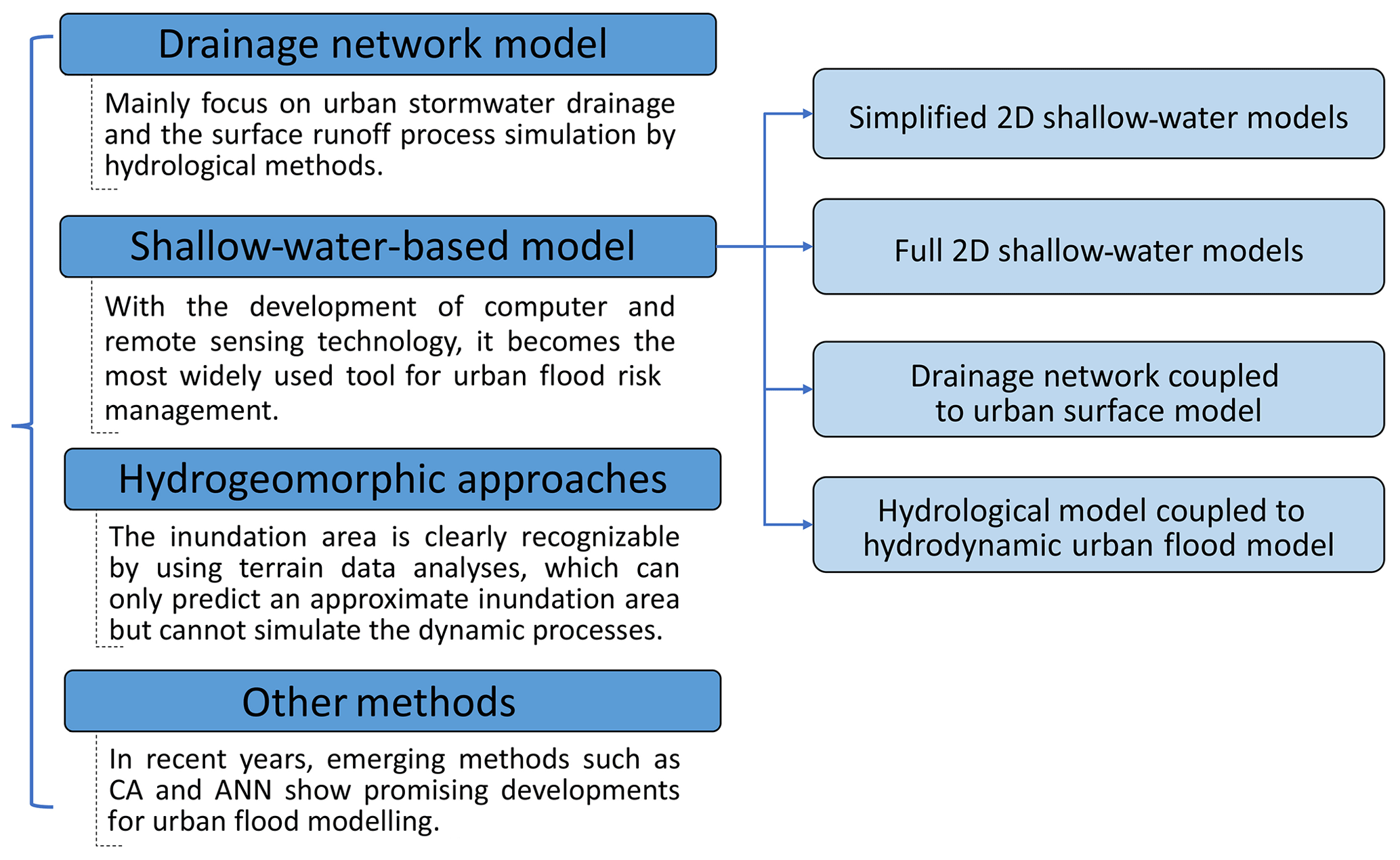
Fluvial and coastal flood modelling and inundation mapping have been studied extensively and have become common practices in past decades (Néelz and Pender, 2013; Rubinato et al., 2019). These models greatly rely on the quality of topographic data and hydrological data as input. Unlike river- and rural-catchment terrain, urban areas generally have more complex and irregular topography with buildings, drainage networks, and other critical infrastructure. The dynamics and non-linear interactions of hydrological, hydrodynamic, and hydromorphological processes in such topography present substantial modelling challenges. Also, the heterogeneity of an urban surface challenges the parameterisation of urban flood models. Significant efforts have been made to advance the development of a reliable model, which is essential for building urban flood resilience (Song et al., 2014). Owing to the progress in computational power and data availability, the quality and complexity of these models have steadily increased, beginning with a simplified model framework a decade ago to more sophisticated numerical models in recent years (Mignot et al., 2019). Amongst these, four groups of models are the most concerned with ongoing urban flood simulation research (Fig. 1): (1) drainage network models (e.g. Djordjevic et al., 1999; Simões et al., 2010); (2) shallow-water-based models that solve simplified or full shallow-water equations (SWEs) with a varying conceptualisation of sewer flows, e.g. the diffusive version of LISFLOOD-FP (Bates et al., 2010), CityCAT (Glenis et al., 2018), and HiPIMS (Xia et al., 2019); (3) hydrogeomorphic approaches that predict the inundation area based on geomorphic features (e.g. Nardi et al., 2013; Di Baldassarre et al., 2020); and (4) other methods such as cellular automata (CA) and artificial neural networks (ANNs) (Ghimire et al., 2013; Guidolin et al., 2016; Berkhahn et al., 2019).
The accuracy and efficiency are generally two key indicators for evaluating the performance of these models but are often in conflict with each other. For the fast, simplified models, some key information is lost, leading to less accuracy in the results, without even including the key inundation feature. Sophisticated models can predict more flood information but at the cost of more high-quality data input and expensive computation. Although still in their infancy, models for reproducing the interaction of surface water and drainage flows are being developed (Leandro et al., 2009; Seyoum et al., 2012; Bazin et al., 2014). Large-scale urban flood simulation is still a challenge for these models due to the requirement of extensive input data, such as a pipe network. Several studies have reviewed flood models for fluvial and coastal inundation (e.g. Teng et al., 2017), but none have systematically reviewed the specific type of models for urban surface water flooding driven by intense rainfall. This paper aims at evaluating the available urban flood models by exploring their advantages and disadvantages for various applications.
The health risk associated with pollutant transport during urban flooding is also an important issue to be modelled and overcome. Urban flooding can cause a surcharge of sewer flow, flush pollutants, and wastewater to public areas, thus causing health risks for the people, such as breakout of epidemic disease and drinking water pollution (Beg et al., 2020). However, surface water pollution heavily relies on the surface water dynamics. Therefore, this review only focusses on flood hydrodynamic modelling. The paper will first present the systematic methodology for selection of literature in Sect. 2. Then, the methods of different types of urban flood models in the literature are summarised and overall described in Sect. 3. In Sect. 4, the main advantages and limitations of each model type are evaluated and discussed, which provides guidance and suggestions for the optimisation of the method or model in practice. Section 5 discusses future research needs and challenges. Conclusions are drawn in Sect. 6.
In this study, two steps were taken with predefined criteria to systematically filter and select all potential papers based on an established research methodology (Booth et al., 2016). The following is a detailed description of how to use this method for a systematic overview (Gradeci et al., 2019).
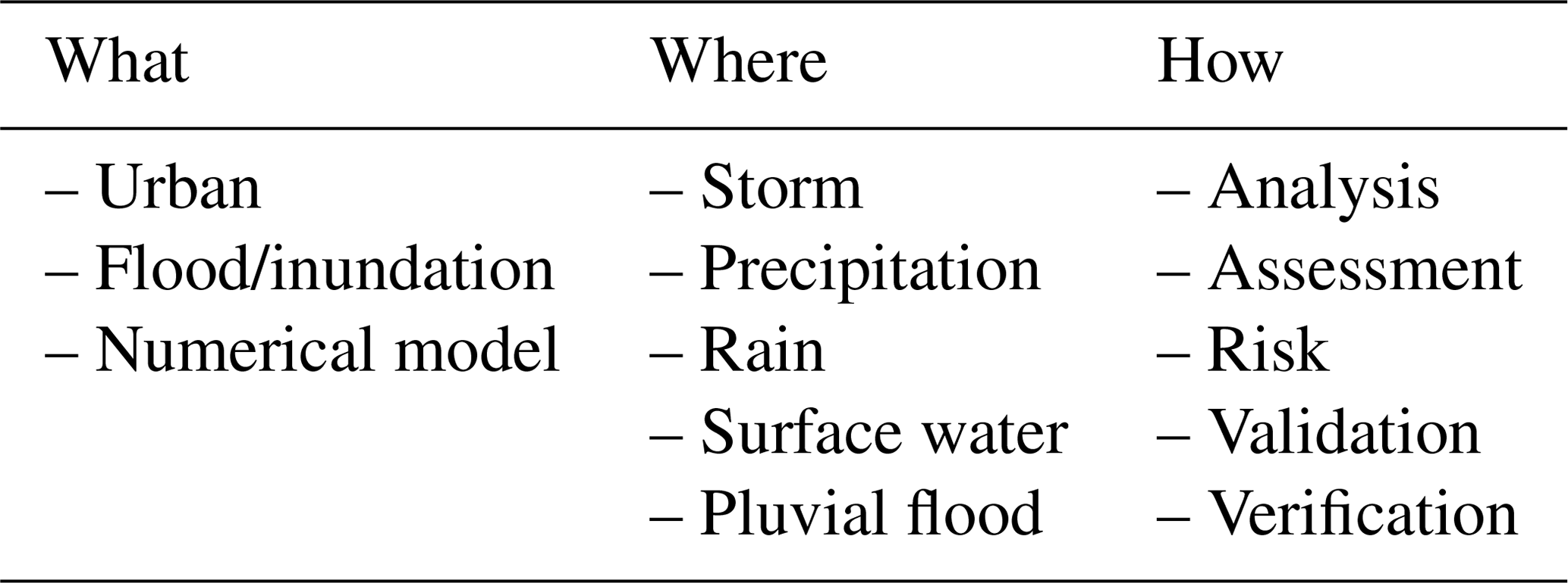
The research theme in the present study was determined as how urban surface flood models have been developed and applied. In order to establish a research entry point and the preliminary investigation scope, the first step was to identify the keywords as search terms. With reference to the selected representative literature (Djordjevic et al., 1999; Simões et al., 2010; Bradbrook et al., 2004; Bates et al., 2010; Glenis et al., 2018; Xia et al., 2019; Ghimire et al., 2013; Guidolin et al., 2016; Berkhahn et al., 2019), the keywords are determined as shown in Table 1. The review was conducted in The University of Hong Kong (HKU) library (Engineering) (the core databases are Engineering Village 2, INSPEC, SciTech premium collection, Scopus, Web of Science, and Google Scholar). Furthermore, this study concentrated on research models, rather than commercial models, which typically involve software applications.
The second step is the final screening, which is based on the chosen electronic database (HKU library – Engineering) of peer-reviewed literature. The predefined exclusion criteria were set to screen the literature (Table 2). The search scheme is illustrated in Fig. 2, outlining the number of papers retained at each stage. There was no limitation to the research period and the search was conducted on 6 October 2020. For the same model in different literature sources, newly published papers are preferred. And journal papers take precedence over conference papers. Finally, 48 papers were selected. The literature pool is listed in Table S1 in the Supplement.
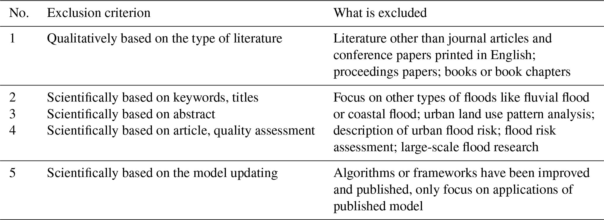
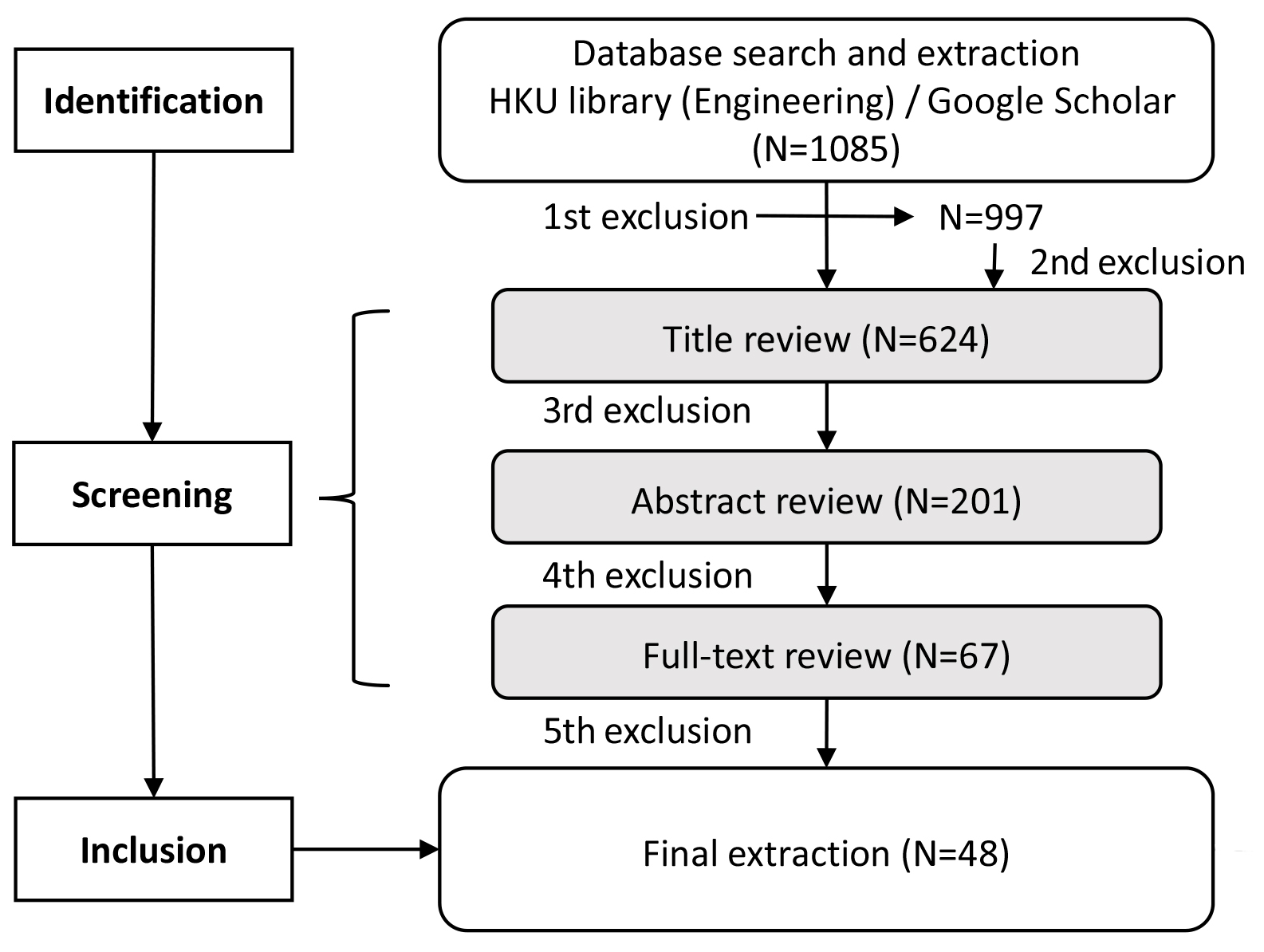
Figure 2Preferred Reporting Items for Systematic Reviews and Meta-Analyses (PRISMA) framework showing the literature screening process.
As introduced above, urban flood models are classified by four types. Selected studies and relevant models are listed in Table 3. The core of these models mainly lies in how to quantify the three key components of flooding in urban systems – rainfall, surface runoff, and drainage flows – as shown in Fig. 3. The key methods used in each type of model are summarised below.
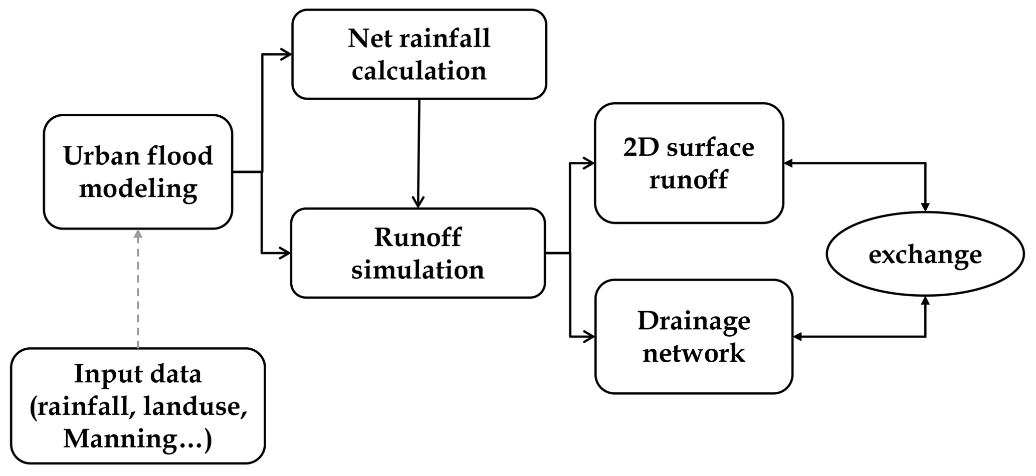
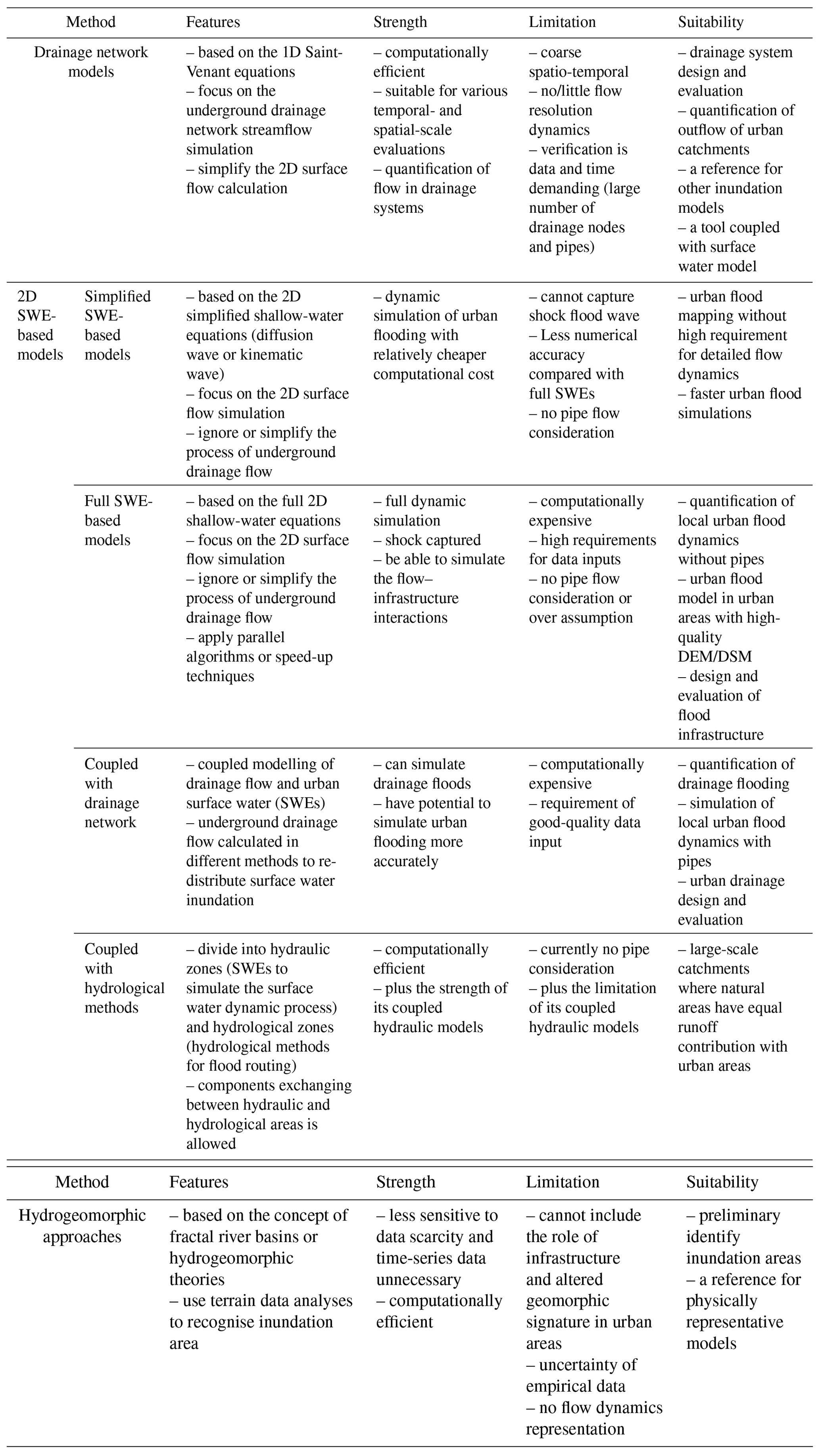
Table 3Summary of the characteristics pertinent to urban flood models.
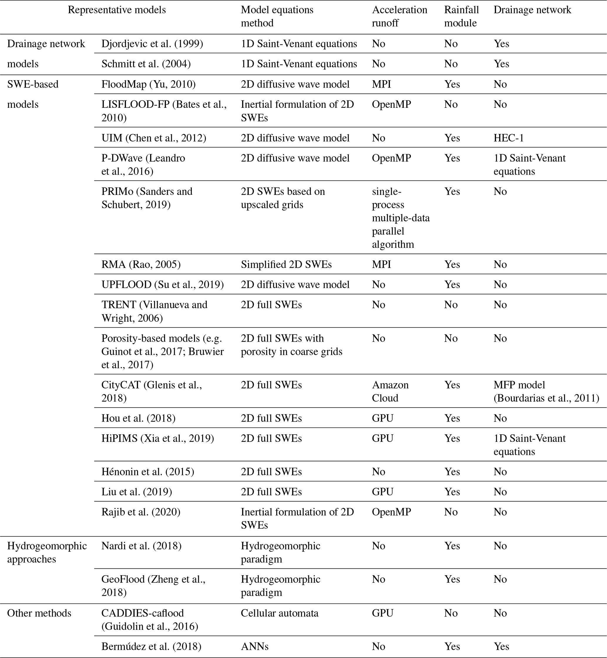
* MPI is Message Passing Interface; OpenMP is Open Multi-Processing; HEC-1 (Hydrologic Engineering Center-1) is a flood hydrograph package developed by the US Army Corps of Engineers which enables the flood forecaster.
3.1 Drainage network models
The drainage network is the key infrastructure that drains storm water runoff on urban areas. Inundation in urban surfaces is always caused by the surcharge, which means the capacity of the drainage network cannot support the urban surface runoff. Therefore, drainage network models are often used for simulating urban storm-water runoff when detailed pipe-network data are available (Lee and An, 2019). The main goals of such models are to simulate the streamflow in the underground drainage network and to provide the flow hydrograph at the outlets of urban catchments or sub-catchments.
In a confined channel or in a pipe, the flow is generally considered to be one dimensional. Drainage network models solve equations derived by ensuring mass and momentum conservation between two cross sections a distance x apart, which yields the well-known one-dimensional Saint-Venant equations. In the urban drainage network, as the pipeline discharge increases or decreases, the pipeline flow may change from open-channel flow to pressurised flow back and forth. Therein, the open-channel flow has a free surface, and the pressure can be approximated as satisfying the assumption of hydrostatic pressure. But the open-channel flow control equation is used for the simulation of open-channel drainage flow (Eqs. 1 and 2). However, the pressurised flow does not have a free surface, and the pressure no longer meets the hydrostatic pressure assumption. Thus, a set of modified equations (Eqs. 3 and 4) are used. These models were also called “0-term” models (Néelz and Pender, 2013) corresponding to the full-term shallow-water-based models.
The mass and momentum conservation equations for open-channel flows with water level Z and flow discharge Q as variables are as follows.
Here Q represents the flow discharge, Z represents the water level, Sf represents the friction slope, A is the flow cross-section area, B is the width of water surface, t is time, and g is the gravitational acceleration.
The mass and momentum conservation equations for pressurised flows with piezometric head H and flow discharge Q as variables are as follows:
where H is the piezometric head, and a is the wave velocity.
A drainage network model is generally coupled with an urban hydrological or hydraulic model to quantify surface runoff on the urban surface. For example, urban hydrological models, such as the Urban Drainage and Sewer Model (MOUSE) (DHI, 2004), EPA SWMM (Rossman, 2010), and other research models (Schmitt et al., 2004; Simões et al., 2010), are frequently implemented or redeveloped to simulate urban rainfall–runoff and flood overcharge from drainage maintenance holes. However, these models cannot reproduce the dynamic processes of urban inundation. To simulate urban surface water flooding, dual drainage models that combine drainage networks with urban street networks have been developed (Djordjevic et al., 2005; Simões et al., 2010). During flood events, drainage pipe flows generally produce surcharge at urban drainage manholes, resulting in flooding on the street surface. Dual drainage models take into account both flows within the drainage system and surcharge over the streets during intense rainfall. This type of model has two interactive modules: (1) an underground module that consists of a sewer system with known manholes, inlets, and control structures and (2) a surface module including flow paths, retention basins in local depressions, or other artificial control structures (brinks, ponds) made of channels (Mark et al., 2004; Djordjevic et al., 2005). In essence, the 1D model represents the surface flow path (mainly streets) on top of a 1D-pipe-flow model, with exchanges through gully port, catch basin, or other coupling junctures. Then, urban flood risks are assessed based on a dual-drainage-modelled output hydrograph, the water remaining in the drainage network, and water depths on street surfaces with the aid of the analytical capabilities of Geographic Information System (GIS). However, a 1D model cannot be used to reproduce the rainfall–flood process as it cannot be one-way flow in the whole urban area. It is considered over-assumed when treating surface flow as 1D channelled flow, which clearly limits its application.
3.2 Shallow-water-based models
In recent decades, high-resolution digital elevation model (DEM) and digital surface model (DSM) data with more detailed spatial information are increasingly available. Hydrodynamic models built upon SWEs have demonstrated strong capabilities in providing more detailed flood information in urban areas, such as distributed floodwater depths and velocities. SWE-based models have been frequently applied to fluvial and coastal flooding but were recently refined for urban surface water flooding (Gómez et al., 2011; Xia et al., 2017).
Urban surface floods generally do not have a fixed path or direction and are generally widespread in two-dimensional or even three-dimensional space in the case of large water depth. The motion of an incompressible, viscous fluid can be described by the Navier–Stokes equation. Due to the heavy calculation burden and complicated algorithm design, it is obvious that traditional hydrological methods and one-dimensional hydrodynamic models cannot effectively deal with such problems. In practical applications, the equations are generally simplified appropriately according to the specific characteristics of the flow conditions. The urban surface runoff is generally shallow-water flow; that is, the movement of shallow water with free surface under the action of gravity. The two-dimensional shallow-water equations can realise the accurate calculation of urban flood inundation, which can be obtained by simplifying the Navier–Stokes equations in the vertical direction. It can meet most of the application requirements in engineering practices and has been widely used in shallow-water research. Based on comprehensive reviews of SWE-based models for both fluvial flows and urban surface water, we summarise the governing equations as below (Audusse et al., 2004; Liang and Marche, 2009; Toro, 2013).
where x and y are the two Cartesian directions, t is time, h is the water depth, qx and qy are the x and y components of the discharge per unit width, u and v are the x and y components of the flow velocity, z is the bed elevation, g is the gravitational acceleration, R is the source or sink term representing net rainfall intensity (runoff term) (rainfall intensity is accumulated into the mass equation as a mass input), and E is a pipe–surface exchange flow term to connect the flow between 2D surface runoff and 1D drainage network flow. Sb and Sf are the bed slope source term vectors and friction effect source term vectors, respectively. The numbers below the equation represent the different terms of the shallow-water equations: (1) local acceleration, (2) convective acceleration, (3) pressure + bed gradients, and (4) friction.
3.2.1 Simplified 2D shallow-water models
SWE-based models have been explored in recent decades for improving both the efficiency and accuracy of simulations. However, there are challenges to modelling urban surface water floods using this approach, due to the complex and irregular terrain and the lack of sufficient input data, especially for large-scale modelling (Leandro et al., 2016). Since full shallow-water models are computationally expensive, some studies suggest omitting or approximating less significant terms in Eqs. (5)–(7) to reduce model complexity and save computational costs (e.g. Yu and Lane, 2006; Bates et al., 2010; Martins et al., 2017a; Sanders and Schubert, 2019). The simplified SWE-based models include 2D diffusion wave models that neglect the inertial – local acceleration term (1) – and advection – convective acceleration term (2) – terms, “3-term” models (Bradbrook et al., 2004; Bates et al., 2010), and 2D kinematic wave models that omit pressure terms (3) as well, also called “2-term” models (Hunter et al., 2007).
The kinematic wave model was initially developed for fluvial flooding with deeper water (e.g. Singh, 2001; Hunter et al., 2007). However, major assumptions have to be made when being applied in urban surface water flooding, which has relatively shallower water. Such 2D kinematic wave models can give a reasonable level of accuracy only for simple flow regimes (Zhang, 2015). So, the diffusion wave approximation, introduced by Cunge (1980), was considered a more practical simplification. The diffusion wave model is also called the zero inertial model. Yet, the lack of inertial terms may raise issues of model accuracy and stability, e.g. the control of calculation time. When the constant time step is not small enough, “chequerboard”-type oscillations will be generated, where water in one particular cell drains into the adjacent cell in a single, large time step and flows back in the next time step (Hunter et al., 2005; Zhang, 2015). This results in a loss of water mass, which affects the accuracy in predicting “shallower” urban surface flooding driven by rainfall (Su et al., 2019).
To avoid instability, a flow limiter is generally used in a diffusion wave model to prevent water leakage from a given cell in a single time step. Hunter et al. (2005) proposed an adaptive time step as an alternative to the flow limiter. A similar method is also applied in P-DWave (Leandro et al., 2016). Later work by Hunter et al. (2008) found that a partial inertial model (also known as a local inertial model or simple inertial model) can be set up by including the local acceleration term, which allows for the use of a larger time step and eliminates severe oscillation in the water. This assumes that flow advection is inconsequential in floodplains, so the convective acceleration term can be excluded. Several other studies (e.g. Fewtrell et al., 2011; De Almeida and Bates, 2013) validated the simplified approach through numerical cases against field data and analytical solutions. De Almeida and Bates (2013) applied the partial inertial approximation model to several flow problems, showing that the scheme could provide relatively accurate and efficient results. Several other models have been developed based on a similar theory (e.g. Yu, 2010; Leandro et al., 2016).
Applications of these models to real-world events indicate that inundation in urban areas could be adequately modelled if considering inherent uncertainties of various data input and model conceptualisation (Willis et al., 2019). Some studies (e.g. Leandro et al., 2016; Hénonin et al., 2015) developed subgrid models that improve calculation efficiency while ensuring certain accuracy by implementing relatively coarse numerical solutions. To increase model accuracy, Su et al. (2019) proposed a calculation of the tangential gradient at the cell edge to improve the accuracy. Hunter et al. (2005) also mentioned that, owing to the stricter time step control needed for stability, the effect of diffusion wave approximation in saving computational time is not evident in high-resolution simulations.
3.2.2 Full 2D shallow-water models
Simplified SWE-based models are less computationally expensive compared to full 2D shallow-water models because of the simplification or omission of certain hydraulic processes. However, when facing complex flow regimes, e.g. transcritical flows, supercritical flows, or shock-like flow discontinuities, full 2D shallow-water equations, Eqs. (5)–(7), are essential to reproduce the full flood dynamics. Full SWE-based models have presented a potential for appropriate approximations in specific situations and are commonly used for surface water issues (Sanders et al., 2008; Liang and Marche, 2009; Ferrari et al., 2019). The 2D dynamic wave models have been considered the only option to predict the backwater effects accurately and hydraulic–hydrological discontinuities (Gómez et al., 2011). Fluvial flood models based on full SWEs were developed by solving Eqs. (5)–(7) in past decades. Schemes based on the finite-volume method and approximate Riemann solvers have gained recent attention with their adequate handling of discontinuities in the flow field. The good track record of full-SWE research provides a solid basis for extending its application to urban surface flood modelling. As indicated in Fig. 3, urban surface water flooding also includes rainfall, infiltration, and flow exchange terms. Thus, further efforts are needed to achieve urban surface flood modelling by using full SWEs.
There are numerical challenges when applying fluvial flood dynamic models to urban surface water flooding:
-
representation of urban terrain,
-
appropriate processing of shallow surface water in an irregular bed, and
-
balance of computational efficiency and accuracy.
In recent years, studies have been undertaken to overcome these numerical challenges. For example, Xia et al. (2017) introduced a numerical scheme for modelling overland flows over complex bed terrain by developing methods to maintain numerical stability and accuracy. Unlike natural catchments, urban areas contain complex topographic features and underground infrastructure that heavily affect urban inundation. For this, some studies proposed a porosity-based SWE model to generalise the effects of dense urban buildings (Sanders et al., 2008; Kim et al., 2015; Guinot et al., 2017; Bruwier et al., 2017; Ferrari and Viero, 2020). Bruwier et al. (2017) proposed an approach to determinate the porosity parameters reflecting the different characteristic sizes of obstacles. This method can obtain speed-up values between 10 and 100 while the errors on water depths remain low. Ferrari and Viero (2020) presents an algorithm to automatically extract the spatial distribution of the porosity parameters by geometrical information in complex urban areas. The schemes were shown to provide reasonably good results in experimental and city case studies (Ferrari and Viero, 2020; Viero, 2019; Mel et al., 2020). The studies on porosity-based models mostly focus on numerical schemes for solving urban flood dynamics driven by upstream inflows rather than direct rainfall. Few large-scale applications in surface water flooding driven by rainfall have been studied. Moreover, sophisticated urban flood models have been developed recently by including detailed urban surface buildings and underground drainage systems. For example, Glenis et al. (2018) presented a full 2D SWE-based model that includes not only a module simulating pipe flow but also representative buildings and urban infrastructure based on high-resolution DEM.
For large-scale applications of full 2D SWE-based models, high-resolution data, such as DEM/DSM, are required to represent urban building blocks and surface conditions, since street-level or metre-scale modelling implies a large number of computational grids. Parallel algorithms and speed-up techniques to overcome this dramatic increase in computational cost have been the focus of research in the last decade. Numerous studies have justified that a GPU-based parallel algorithm is capable of speeding up a flood model by over 10 times (e.g. Kalyanapu et al., 2011; Vacondio et al., 2014; Smith and Liang, 2013). Particularly for catchment-scale flooding, Xia et al. (2019) developed a GPU algorithm to accelerate a flood model and successfully reproduce the rainfall–inundation process in Eden Catchment caused by the 2015 storm Desmond (2500 km2 with resolution of 5 m). Hou et al. (2018) presented a GPU-based urban flood model to reproduce a flood event with 100-year return period design storm in Morpeth town, UK. Many other studies also indicate that real-time modelling of flooding is possible in a domain with over 100 million grids by using algorithms with GPU acceleration. Moreover, cloud computing has been used to accelerate a sophisticated urban flood model (e.g. Glenis et al., 2018). In summary, to achieve large-scale urban modelling, significant assumptions are needed with a simplified model of a coarse scale, as stated in Sect. 3.2.1, while full SWE-based models are frequently based on GPU or cloud computing.
3.2.3 Drainage network coupled to the urban surface model
In SWE-based dynamic models, the effects of drainage networks are mostly either neglected or over-assumed by a constant drainage capacity. Even though the studies mentioned above have developed advanced urban flood models, drainage flows were not taken into consideration (e.g. Sanders et al., 2008; Xia et al., 2019). However, the drainage network plays a crucial role in draining urban runoff, which will redistribute surface water inundation during flooding (demonstrated in Fig. 4). The omission or over-assumptions may result in the mis-simulation of surface water depths, inundation coverage, and duration, particularly at a localised scale. In fact, the drainage network should be especially taken into account when the duration of the inundation represents a key variable for a correct flood risk evaluation. Although still in its infancy, coupled modelling of drainage flow and urban surface water is increasingly attracting attention using 1D pipe flow and 2D surface flow (Seyoum et al., 2012; Chen et al., 2015; Bazin et al., 2014; Leandro and Martins, 2016; Martins et al., 2017a; Li et al., 2020). Such models represent drainage flow by a 1D pipe model and quantify the effluents and influents via manholes using the weir or the orifice equations (Bazin et al., 2014). Urban surface water is reproduced by these coupled models with a 2D shallow-water model, allowing for the simulation of the time series of flow spreading across the urban area.

Based on the existing studies, there are three commonly used methods to characterise drainage flow in urban flooding simulation.
-
Using a runoff term R in one of three typical techniques: (1) reducing the rainfall rate i in the runoff term R in all of the study area, which is i minus Ip, a constant value representing the drainage capacity of the pipe network; (2) an additional value is added to the natural infiltration I of the soil in the runoff term R of the entire study area to represent the capacity of the drainage network, which is I plus Ip; and (3) the drainage capacity of the pipe network is accumulated to the actual layout range (e.g. Hou et al., 2018).
-
Exchanging discharge through coupling links by various approaches, including orifice and weir equations (Chen et al., 2007; Su et al., 2019; Rubinato et al., 2017, 2018), inlets or gully capacities (Leandro et al., 2009), and the displacement of manholes covers (Chen et al., 2016).
-
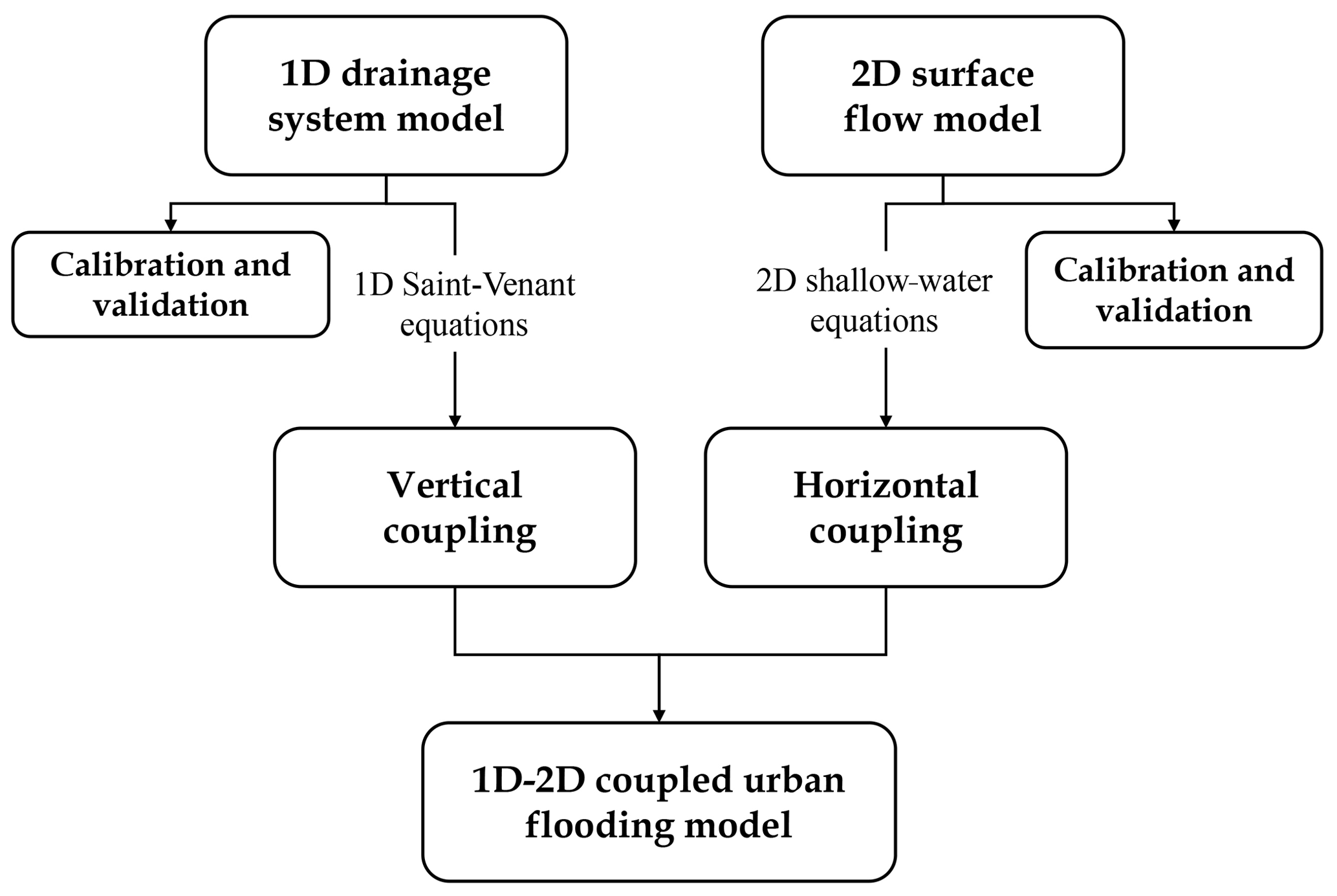
Applying 1D Saint-Venant equations, which is the most widely used and accurate of the three techniques. The surface flow spreading process can be calculated by the 2D model part, obtaining results such as water levels and velocities. Then bidirectional component exchanging is allowed in junction with the coupling 1D drainage model to realise the reproduction of the urban storm-flood process (Carr and Smith, 2007; Mark and Djordjevic, 2006; Li et al., 2020). A model concept is demonstrated in Fig. 5. The horizontal coupling means components exchanging between the 2D surface cell and the drainage cell in horizontal direction, and vertical coupling means the discharge redistribution in the drainage cell, to calculate surcharge from the urban surface into the drainage or backflow from the pipe.
The first method does not consider the influence of the surface morphology of the pipe network system or the process of surface runoff flowing into the pipe network. Therefore, the rainwater is reduced before reaching the road surface, which is inconsistent with the actual process. Also, surface runoff into the storm-water inlet is not constant, and the simplification of the first method can be problematic. For a more accurate simulation of urban flooding, the second method has been widely applied in the last decade.
Recently, the third coupling approach has been increasingly investigated. For example, Martins et al. (2017b) validate a 2D shock-capturing flood model coupled with a 1D unsteady pipe flow solver based on both quadrilateral-structured and triangular-unstructured mesh types. Li et al. (2020) proposed a junction simulation approach, instead of the traditional method solving the continuity equation, which is coupled with the widely used two-component pressure approach (TPA) and led to a new integrated drainage network model. The new 1D–2D coupled drainage network model was validated against an experimental and several idealised test cases to demonstrate its potential for efficient and stable simulation of flow dynamics in drainage networks. However, there are physical complexities and uncertainties for applications in real-world events.
3.2.4 Hydrological model coupled to hydrodynamic urban flood model
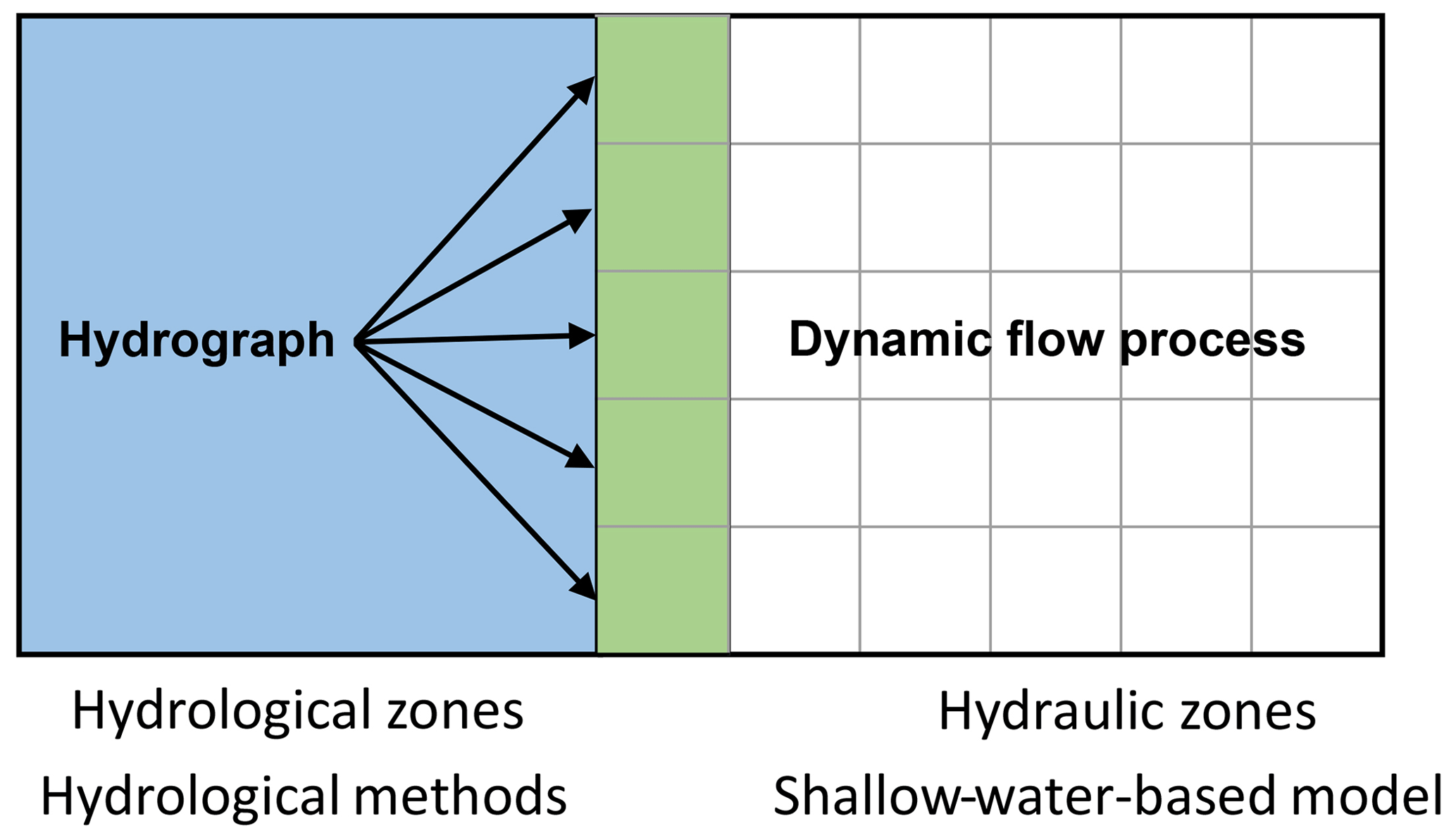
Even with the rapid development of SWE-based models, it is still challenging for both simplified and full models to be applied in large-scale events. A coupled modelling framework has been developed for large-scale flood modelling (Liu et al., 2019; Rajib et al., 2020). More specifically, as shown in Fig. 6, the model framework divides the hydraulic structures, river reach with complicated flow conditions and urban inundated areas, into hydraulic zones (gridded white zone), while the rural domain is defined as hydrological zones (blue zone). In hydrological zones, selected hydrological methods are applied for flood routing, and the SWEs are used to simulate the surface water dynamic process in hydraulic areas. The green area in Fig. 6 is the boundary area, where bidirectional components exchanging between hydraulic and hydrological areas are allowed to update the calculation.
There are two common hydrological and hydrodynamic coupling approaches: external coupling and internal coupling. For external approaches, the results of hydrological models, such as hydrographs, can be applied as upstream or lateral boundary conditions for hydraulic models. The one-way and two-way transitions are all allowed in this method. It is suitable and has a wide range of applications in urban catchments with a complex river network system (e.g. Lian et al., 2007; Mejia and Reed, 2011; Kim et al., 2012; Liu et al., 2019). For internal approaches, the hydrological models and hydraulic models are calculated separately and update the information at the shared boundary with a certain calculation time step interval. The main intention of such model frameworks is to predict urban flooding from the perspective of broader catchment scales efficiently with reasonable accuracy. To a certain extent, such model frameworks also reduce the uncertainty effects of hydrodynamic models when applying in upstream rural catchments.
3.3 Hydrogeomorphic approaches
Apart from the models reviewed in Sect. 3.1 and 3.2, an emerging method, the hydrogeomorphic approach, has been recently developed for flood hazard management and mapping (Nardi et al., 2013; Zheng et al., 2018). Unlike the physical-based models above, hydrogeomorphic approaches are based on the concept of fractal river basins or hydrogeomorphic theories, and floodplains are identified as unique morphologic landscape features. The inundation area is clearly recognisable by using terrain data analyses (Di Baldassarre et al., 2020). It is not necessary to estimate the synthetic flood hydrograph, and the floodplain can be determined consistently in different regions. Specifically, a simplified hydrologic analysis can provide the elevation thresholds of the potential inundated grid under different discharge conditions and then identify the floodplain cells for a different return period (Nardi et al., 2018).
More recently, the increasing availability of high-accuracy digital terrain models (DTMs) provides new opportunities for morphometric analysis of floodplain mapping. And this floodplain delineation method has been of significant interest because of the low requirements of time-series data and high computational efficiency. It is being developed to apply in global and large-scale catchment fluvial flood mapping and has also been applied in urban areas in recent years (Brown de Colstoun et al., 2017; Nardi et al., 2018). However, its model concept implies that such a method can predict an approximate inundation area but cannot simulate the dynamic processes of flooding (time series of water depths, velocities, etc.) that are vital for risk assessment.
3.4 Other methods
3.4.1 Cellular automata models
Recently, several studies have evaluated an alternative urban flood modelling approach instead of solving the SWEs, and the cellular automata (CA) approach shows great prospects in urban inundation simulation (Dottori and Todini, 2011; Ghimire et al., 2013; Guidolin et al., 2016). The CA models represent the discrete simulation area with grids. Apart from the regular properties, such as the state of each cell, distribution of surrounding cells, and discrete time step, there are a set of transition rules. Based on the previous state of the cell and neighbouring cells, the rules control the evolution of each cell state (Teng et al., 2017). Austin et al. (2014) successfully developed a series of CA models (e.g. CA1D and BCA1D) to simulate sewer network flow with various transition rules. Compared with the traditional 1D hydraulic models, these simplified CA models can produce reliable results with high computational efficiency. Guidolin et al. (2016) developed a weighted 2D CA inundation model, CADDIES 2D flood model WCA2D, that obtained the results that are consistent with the accuracy of that diffuse wave model. The CA algorithm is suitable for parallel computing as the hydraulic properties evolution of each cell only requires the state of it and the surrounding cells at the previous calculation time step. However, CA approaches are only newly developing in the field of urban flood simulation, with just a few emerging in urban applications. It is shown that CA models can be valuable tools for flood simulation. However, there is only limited literature, and most of the tests are ideal cases. Besides, it showed less accuracy in reproducing two-dimensional flow dynamics with respect to a model based on the full shallow-water equations. So, in this aspect, these models still need to be further verified in 1D and 2D practical applications (Guidolin et al., 2016).
3.4.2 Artificial neural network models
As high-quality data become more available, data-driven models, such as artificial neural networks (ANNs), have emerged and can be useful in view of their merits in computational cost and speed. An ANN is an approximation technique that has been widely used in the water resources field (Yaseen et al., 2015; Wolfs and Willems, 2014). The applications to urban surface water flooding are still fairly scarce. However, Bermúdez et al. (2018), for example, established a model based on two different ANNs to simulate the urban sewer-flood procession, and Berkhahn et al. (2019) presented an ANN-based model to predict the maximum water levels during a flash flood event in an urban river or urban area. The computation times of these models are significantly less than their predecessors, and the results are supported with abundant field data, confirming the importance of having high-quality data.
Each model has advantages and limitations when applied in urban flooding, which will be discussed in this section. A comparative summary is listed in Table 4.
Table 4Comparative summary of the relative advantages and disadvantages of different models.
4.1 Drainage network models
Drainage network models, particularly coupled with hydrological methods, are highly computationally efficient, owing to their simple structures; thus, they show merits in applications that focus on flood-related hydrological analysis in an urban catchment and have low requirements for the representation of full hydrodynamics. The fast operation of this model type makes it suitable for large-scale simulations with various temporal scale evaluations that require thousands of longer-run simulations with little detail of the flow behaviours. Inclusion of pipe network and manholes in models can help to estimate potential surcharge, which can be used as a reference for other inundation models, e.g. 1D street network models or 2D surface water models. The surface runoff simulation of these models is mainly based on the conceptual hydrological models or grey-box models. Although urban rainfall–runoff processes can be properly estimated by these models through linking a drainage network, the over-assumption of flow dynamics does not allow for the simulation of surface flow inundation, which is a key indicator for risk assessment. Thus, there will be a lack of detailed spatial dynamic information of urban surface waters, such as flood depth and velocity. Moreover, this type of model usually solves the 1D equations for drainage flows. At the city scale, the drainage network system is often complex with a large number of drainage nodes and pipes. Although automatic GIS procedures can improve efficiency to a certain extent, it is still time-consuming data-demanding to set up and verify this type of model. For operational flood management, there is currently a high demand for thorough, detailed spatial information, such as the depth and velocity of surface flow in each street and accurate data for each residence. Drainage network models cannot meet the above requirements for urban surface water flooding.
4.2 Shallow-water-based models
A power of work has been devoted to developing 2D shallow-water-based numerical models in recent decades. These include simplified and full SWEs models, models coupled with drainage networks, and even coupled hydrological and hydrodynamic models. In the above overview, SWE-based models have proven to be capable of reproducing surface flow reasonably well for flooding in urban areas, accurately predicting velocity, flood extent, and water level.
High-resolution topographical data, such as lidar, DEM, or DSM data, are now becoming available and can have a fine resolution of about 20 cm or even less. Several studies have developed applications of SWE-based models in a variety of scales by developing new algorithms or new model framework and utilisation of high-resolution topography datasets. These models are advancing current practices to make practical simulations of urban surface water inundation driven by extreme rainfall. Experimental and field in situ data have always been considered an essential supporting source for flood model validation. In this concern, some recent studies have specifically developed physical models and approaches to gather detailed experimental or field data to support flood model verification (Rubinato et al., 2013; Lopes et al., 2015; Gómez et al., 2019; Martins et al., 2018). For example, Rubinato et al. (2013) and Lopes et al. (2015) collected hydraulic data form a physical model and applied the data to verify the performance of a numerical model. Although there are some, good-quality benchmark datasets are still lacking in the research community for urban flood model validation.
Compared to full SWE-based models, simplified SWE-based models have been typically used in larger-scale urban flood modelling with coarser grids and simplified treatment of urban features (e.g. city scale, even continental scale) because of the relatively low computational costs and the capability to simulate surface water dynamics (e.g. Yu et al., 2016). However, the inherent model conceptualisation implies that these models cannot capture the shock wave adequately. They may not be an ideal choice when simulating detailed urban flood dynamics with infrastructure.
Recently, sophisticated full SWE-based models have also been applied to city-scale flood modelling with the advances of accelerated algorithms (e.g. Glenis et al., 2018; Xia et al., 2019; Sanders and Schubert, 2019). Such models are capable of simulating the full surface water dynamics. However, they require high-quality data, which could result in high uncertainty depending on the data source (Willis et al., 2019). Both simplified and full SWE-based models have weaknesses, and further improvements are the following current challenges:
-
The concentration of buildings in urban areas plays a vital role in the magnitude of inundation and its hydrodynamics; however, current SWE-based models either ignore its effects or make over-assumptions. Some attempts with the inclusion of urban features mainly focus on small-scale validations of numerical schemes, whereas larger-scale applications have been hardly studied.
-
The computational cost of 2D full SWE-based models is especially significant for high-resolution modelling, which is necessary for representing urban features, such as buildings. While sometimes acceptable for event-based applications, this price is impractical for real-time simulations that serve as early flood warnings. Despite the rapid development of accelerated computing techniques, 2D shallow-water models are still considered not feasible for calculations in large-scale catchments with fine-resolution grids, because the simulation time required may be prohibitive (Néelz and Pender, 2013). It is a current challenge to balance computational efficiency with accuracy by either optimising numerical algorithms or establishing reasonable model structures.
4.2.1 Drainage network coupled to the urban surface model
As a key feature of urban catchment, the drainage network has also been ignored or generalised with over-assumptions as discussed above. Although there are alternative approaches to treat pipe flows, and coupled hydrodynamic models are emerging, they are still in its infancy for real-world applications (Mignot et al., 2019). Theoretical or experimental testing for coupled hydrodynamic models may be successful (Li et al., 2020), but improved model performance has not actually been reported when including a drainage flow model into real-world surface water flood modelling. Also, the drainage network data and unclear coupling mechanisms of pipe flow and surface water heavily limit its large-scale applications in real-world applications. Nonetheless, the detailed model would be applicable to the detailed flow dynamic investigation in pipe and urban surface systems at a localised scale.
4.2.2 Coupled hydrological and hydrodynamic urban flood models
By dividing the simulated domain into hydrological and hydraulic zones, these models alleviate the issue of expensive computational costs that pure hydrodynamic models encounter in large-scale applications. Therefore, they are suitable for predicting urban flooding in large-scale catchments, where natural areas have similar runoff contributions to urban areas. Similarly, with pure hydrodynamic models, existing studies also either neglected or made significant assumptions on the treatment of pipe flows.
4.3 Hydrogeomorphic approaches
Hydrogeomorphic approaches can identify the inundation area directly from the topography. Thus, it requires much less computation time and no time-series data. However, there are still many limitations for the application of these.
-
Only approximated inundation area can be obtained. Flow dynamic information (water depth, velocity, etc.) cannot be provided.
-
The effects of recent anthropogenic modifications on a floodplain or urban surface features will increase uncertainty in a floodplain map. There is no effective way to characterise infrastructure and the altered geomorphic signature in highly urbanised areas.
-
The resolution and accuracy of DTMs, as well as terrain data processing and analysis, are challenging.
-
Empirical data related to flood stage are needed to determine the floodplain flow depth scaling relationship. However, there are uncertainties in the data availability and quality. It directly affects the calculation of such a relationship, thereby leading to inaccurate prediction of flooding areas.
However, flood mapping can be considered a complement to physically based hydrodynamic modelling. For example, using an ungauged condition to preliminarily identify inundation areas can provide references for physically representative models.
5.1 Refinement of SWE-based models
In view of the current advances of urban flood models, there are still deficiencies in improving model reliability and efficiency. Urban areas have many complex underlying surface characteristics, and in reality, when the capacity of drainage networks is insufficient, the pipe flow will overcharge to the ground surface. At present, simulation methods of the exchange of pipe flows and surface water have only focused on local-scale modelling. Some existing numerical models often directly use empirical formulas or simplified methods that are still lacking in stability and accuracy. Therefore, mechanisms between pipe flow and surface water and their modelling approaches would help simulate drainage flooding in urban areas. This could be accomplished by integrating drainage network models with overland flow routing models as some studies have done, but further refinement is needed. Moreover, the question of which model conceptualisation is more appropriate for urban surface water flooding is still unanswered and in need of further investigation with the support of high-quality data.
The spatial heterogeneity of urban catchments is typically more profound, and surface water depths are generally shallower. Both pose numerical challenges in solving SWEs over frictional and extreme, irregular terrain. Although the application of parallel computing technology to improve the computational efficiency of the model has become a trend, efficient urban flood simulation and even real-time flood prediction with better resolutions are still difficult to achieve. In the light of the high computational costs for large-scale modelling at high resolution, more accurate and faster model algorithms are urgently needed. This is critical for achieving a city-scale urban flood prediction in real time.
5.2 Data-driven approaches
With the continuous improvement of remote sensing technology, data become more readily available. A data-rich environment also encourages model calibration, validation, and assimilation. In practical terms, the accuracy of terrain data obtained from modern lidar system has met the requirements for surface flow simulation, but it is necessary to fuse such dataset with digital map data of buildings and land use to realise the maximum development and utilisation of contained information. Furthermore, these terrain data are readily available, and topographical data with a grid scale of roughly 30 m at best hardly meets accuracy requirements for urban flood models.
Model calibration is an essential way to reduce uncertainty over model parameters, but to this day, such data have been scarce for urban areas. Despite the frequency of urban floods, field observations during urban flooding are rarely available for model calibration and validation. Calibration data will be the key factor constraining the future development of urban flood inundation models. Some effective methods or tools are therefore urgently needed to infer from these limited data sources, extending the quantity and range of typically available calibration–validation data. Development of physical urban flood models is an option to gather benchmark data for urban flood modelling as some researchers have done (e.g. Rubinato et al., 2017). Nowadays, the application of social media for both collection and dissemination of flood information is increasingly recognised and thus provides an important basis for flood inundation estimation (Fohringer et al., 2015; Smith et al., 2017). The flood related information provided by the general public through social media such as Twitter or Weibo is also effective and a valuable calibration–validation data source as an addition to the hardly available traditional monitoring data. Besides, studies (e.g. Waller et al., 2018; Ziliani et al., 2019) have verified that the combination of data assimilation and numerical model is used operationally to improve model performance and reduce uncertainties in flood prediction. Ziliani et al. (2019) assimilated field data into the flood model, and the prediction result was improved up to 90 %. Among the relevant literature, this method is mostly applied to fluvial floods with the support of satellite-based data or field water-level measurements but rarely applied to urban pluvial floods. Moreover, as it is recognised that current 2D hydrodynamic models are still computationally demanding and challenging for real-time applications at large-scale, recent innovative modelling exploration has focused on the machine-learning approach for fluvial flooding; for example, a deep convolutional neural network (CNN) method has been developed by Kabir et al. (2020). Such an approach is presented for rapid prediction of fluvial flood inundation. However, a good model training still requires good-quality inundation data and/or a robust hydrodynamic model. Application of the machine-learning approach in urban flood modelling is promising but still very challenging.
5.3 Inter-model and interdisciplinary approaches
Inter-model and interdisciplinary approaches can help to develop the strengths of the various approaches while avoiding shortcomings. Facing the knowledge gap among urban flood risk management, innovative use of computer-based visualisation and virtual reality (VR) technology has been shown to encourage greater engagement amongst diverse participants. A combined simulation–visualisation platform can become an important shared learning tool and there are good prospects for developing an interactive model through the use of computer-based visualisation and virtual reality technology (Wang et al., 2019; Zhi et al., 2020; Yang et al., 2021). The innovation will be helpful for practitioners to communicate and perceive an extreme flood event. With the help of interactive 3D visualisation tools, the extent of inundation and other features such as water depth and floodwater velocity can be better viewed and understood. A combined simulation–visualisation approach can enhance decision support by incorporating 2D inundation modelling and 3D data visualisation. Besides, as mentioned in the previous part, multi-source data such as social media and remote sensing provides an excellent source of model calibration–validation data during and after flood events. Its application may be further enhanced when coupled with accelerated real-time urban flood modelling. In other words, the combination of social media data and an efficient simulation model provides a strong support to build a real-time surface water flood warning system. The astute combination of models is promising, and it will be successfully developed and applied in the future.
This paper presents a comprehensive review of the current advanced urban flood models. Over the last several decades, there have been a variety of methods based on different theories to model various components of urban flooding, yielding a wide choice space for researchers and practitioners. Based on the discussion above, this paper provides insights into urban flood models, current advances, and future challenges. In summary, a drainage network model is a valuable tool with which an urban hydrological method can be coupled. This model is suitable for evaluating and designing a drainage system and assessing flood risk. SWE-based models have received much attention in the last 10 years because of their capability of reproducing the flow dynamics of urban surface water flooding. Simplified 2D SWE-based models are widely used in large-scale urban flood simulation with major assumptions for the purpose of regional-, city-, or continental-scale risk assessment, owing to relatively low computational cost. Full 2D SWE-based models have proven to be capable of simulating flooding in urban areas with complex urban features, but the particularities of urban areas still pose great challenges in both appropriate model generalisation and robust numerical algorithms development. Ongoing research on acceleration methods shows promising developments to speed up 2D models and raises hope for real-time applications with better resolutions in the near future. However, reliable modelling of urban surface water flooding will continue to require quality real-world data.
No datasets were used in this article.
The supplement related to this article is available online at: https://doi.org/10.5194/hess-25-2843-2021-supplement.
KG wrote the initial text and compiled the reviewed studies. MG did the supervision, design of the study, and revision. DY helped review and comments.
The authors declare that they have no conflict of interest.
The study is financially supported by Early Career Scheme from the Hong Kong Research Grants Council (grant number: 27202419).
This research has been supported by the Research Grants Council, University Grants Committee (grant no. 27202419).
This paper was edited by Nadia Ursino and reviewed by two anonymous referees.
Audusse, E., Bouchut, F. o., Bristeau, M.-O., Klein, R., and Perthame, B.: A Fast and Stable Well-Balanced Scheme with Hydrostatic Reconstruction for Shallow Water Flows, SIAM J. Sci. Comput., 25, 2050–2016, https://doi.org/10.1137/S1064827503431090, 2004.
Austin, R. J., Chen, A. S., Savic, D. A., and Djordjevic, S.: Quick and accurate Cellular Automata sewer simulator, J. Hydroinform., 16, 1359–1374, https://doi.org/10.2166/hydro.2014.070, 2014.
Barredo, J. I.: Normalised flood losses in Europe: 1970–2006, Nat. Hazards Earth Syst. Sci., 9, 97–104, https://doi.org/10.5194/nhess-9-97-2009, 2009.
Barredo, J. I., Saurí, D., and Llasat, M. C.: Assessing trends in insured losses from floods in Spain 1971–2008, Nat. Hazards Earth Syst. Sci., 12, 1723–1729, https://doi.org/10.5194/nhess-12-1723-2012, 2012.
Bates, P. D., Horritt, M. S., and Fewtrell, T. J.: A simple inertial formulation of the shallow water equations for efficient two-dimensional flood inundation modelling, J. Hydrol., 387, 33–45, https://doi.org/10.1016/j.jhydrol.2010.03.027, 2010.
Bazin, P.-H., Nakagawa, H., Kawaike, K., Paquier, A., and Mignot, E.: Modeling Flow Exchanges between a Street and an Underground Drainage Pipe during Urban Floods, J. Hydraul. Eng., 140, 4014051, https://doi.org/10.1061/(ASCE)HY.1943-7900.0000917, 2014.
Beg, M. N. A., Rubinato, M., Carvalho, R. F., and Shucksmith, J. D.: CFD Modelling of the Transport of Soluble Pollutants from Sewer Networks to Surface Flows during Urban Flood Events, Water-Suisse, 12, 2514, https://doi.org/10.3390/w12092514, 2020.
Berkhahn, S., Fuchs, L., and Neuweiler, I.: An ensemble neural network model for real-time prediction of urban floods, J. Hydrol., 575, 743–754, https://doi.org/10.1016/j.jhydrol.2019.05.066, 2019.
Bermúdez, M., Ntegeka, V., Wolfs, V., and Willems, P.: Development and Comparison of Two Fast Surrogate Models for Urban Pluvial Flood Simulations, Water Resour. Manage., 32, 2801–2815, https://doi.org/10.1007/s11269-018-1959-8, 2018.
Bernet, D. B., Prasuhn, V., and Weingartner, R.: Surface water floods in Switzerland: what insurance claim records tell us about the damage in space and time, Nat. Hazards Earth Syst. Sci., 17, 1659–1682, https://doi.org/10.5194/nhess-17-1659-2017, 2017.
Booth, A., Sutton, A., and Papaioannou, D., Steele, M. (Ed.): Systematic Approaches to a Successful Literature Review, 2nd Edn., Sage, London, 2016.
Bourdarias, C., Ersoy, M., and Gerbi, S.: A mathematical model for unsteady mixed flows in closed water pipes, Sci. China Math., 55, 221–244, https://doi.org/10.1007/s11425-011-4353-z, 2012.
Bradbrook, K., Lane, S., Waller, S., and Bates, P.: Two dimensional diffusion wave modelling of flood inundation using a simplified channel representation, International J. River Basin Manage., 2, 211–223, https://doi.org/10.1080/15715124.2004.9635233, 2004.
Brown de Colstoun, E., Huang, C., Wang, P., Tilton, J., Tan, B., Phillips, J., Niemczura, S., Ling, P., and Wolfe, R.: Global Man-made Impervious Surface (GMIS) Dataset From Landsat, NASA Socioeconomic Data and Applications Center (SEDAC), Palisades, NY, [dataset], https://doi.org/10.7927/H4P55KKF, 2017.
Bruwier, M., Archambeau, P., Erpicum, S., Pirotton, M., and Dewals, B.: Shallow-water models with anisotropic porosity and merging for flood modelling on Cartesian grids, J. Hydrol., 554, 693–709, https://doi.org/10.1016/j.jhydrol.2017.09.051, 2017.
Carr, R. S. and Smith, G. P.: Linking of 2D and Pipe hydraulic models at fine spatial scales, Water Pract. Technol., 2, 1–9, https://doi.org/10.2166/wpt.2007.038, 2007.
Chen, A. S., Djordjevic, S., Leandro, J., and Savic, D.: The urban inundation model with bidirectional flow interaction between 2D overland surface and 1D sewer networks, in: NOVATECH 2007, January 2007, Lyon, France, available at: https://www.researchgate.net/publication/257199890 (last access: 4 May 2021), 2007.
Chen, A. S., Evans, B., Djordjević, S., and Savić, D. A.: A coarse-grid approach to representing building blockage effects in 2D urban flood modelling, J. Hydrol., 426–427, 1–16, https://doi.org/10.1016/j.jhydrol.2012.01.007, 2012.
Chen, A. S., Leandro, J., and Djordjević, S.: Modelling sewer discharge via displacement of manhole covers during flood events using 1D/2D SIPSON/P-DWave dual drainage simulations, Urban Water J., 13, 830–840, https://doi.org/10.1080/1573062X.2015.1041991, 2016.
Chen, Y., Zhou, H., Zhang, H., Du, G., and Zhou, J.: Urban flood risk warning under rapid urbanization, Environ. Res., 139, 3–10, https://doi.org/10.1016/j.envres.2015.02.028, 2015.
CRED: The human cost of weather-related disasters, 1995–2015, Open Development Mekong, CRED, Brussels, 2015.
Cunge, J.: Practical aspects of computational river hydraulics, Pitman Publishing Ltd., London, 420 pp., 1980.
de Almeida, G. A. M. and Bates, P.: Applicability of the local inertial approximation of the shallow water equations to flood modeling: Applicability Local Inertial, Water Resour. Res., 49, 4833–4844, https://doi.org/10.1002/wrcr.20366, 2013.
DHI: Mouse surface runoff models – Reference manual, Danish Hydraulic Institute, Horsholm, Denmark, 2004.
Di Baldassarre, G., Nardi, F., Annis, A., Odongo, V., Rusca, M., and Grimaldi, S.: Brief communication: Comparing hydrological and hydrogeomorphic paradigms for global flood hazard mapping, Nat. Hazards Earth Syst. Sci., 20, 1415–1419, https://doi.org/10.5194/nhess-20-1415-2020, 2020.
Djordjevic, S., Prodanovic, D., and Maksimovic, C.: An approach to simulation of dual drainage, Water Sci. Technol., 39, 95–103, https://doi.org/10.1016/S0273-1223(99)00221-8, 1999.
Djordjevic, S., Prodanovic, D., Maksimovic, C., Ivetic, M., and Savic, D.: SIPSON : Simulation of Interaction between Pipe flow and Surface Overland flow in Networks, Water Sci. Technol., 52, 275–283, https://doi.org/10.2166/wst.2005.0143, 2005.
Dottori, F. and Todini, E.: Developments of a flood inundation model based on the cellular automata approach: Testing different methods to improve model performance, Phys. Chem. Earth Pt. A/B/C, 36, 266–280, https://doi.org/10.1016/j.pce.2011.02.004, 2011.
Falconer, R. H., Cobby, D., Smyth, P., Astle, G., Dent, J., and Golding, B.: Pluvial flooding: new approaches in flood warning, mapping and risk management, J. Flood Risk Manage., 2, 198–208, https://doi.org/10.1111/j.1753-318X.2009.01034.x, 2009.
Ferrari, A. and Viero, D. P.: Floodwater pathways in urban areas: A method to compute porosity fields for anisotropic subgrid models in differential form, J. Hydrol., 589, 125193, https://doi.org/10.1016/j.jhydrol.2020.125193, 2020.
Ferrari, A., Viero, D. P., Vacondio, R., Defina, A., and Mignosa, P.: Flood inundation modeling in urbanized areas: A mesh-independent porosity approach with anisotropic friction, Adv. Water Resour., 125, 98–113, https://doi.org/10.1016/j.advwatres.2019.01.010, 2019.
Fewtrell, T. J., Duncan, A., Sampson, C. C., Neal, J. C., and Bates, P. D.: Benchmarking urban flood models of varying complexity and scale using high resolution terrestrial LiDAR data, Phys. Chem. Earth Pt. A/B/C, 36, 281–291, https://doi.org/10.1016/j.pce.2010.12.011, 2011.
Fohringer, J., Dransch, D., Kreibich, H., and Schröter, K.: Social media as an information source for rapid flood inundation mapping, Nat. Hazards Earth Syst. Sci., 15, 2725–2738, https://doi.org/10.5194/nhess-15-2725-2015, 2015.
Ghimire, B., Chen, A. S., Guidolin, M., Keedwell, E. C., Djordjević, S., and Savić, D. A.: Formulation of a fast 2D urban pluvial flood model using a cellular automata approach, J. Hydroinform., 15, 676–686, https://doi.org/10.2166/hydro.2012.245, 2013.
Glenis, V., Kutija, V., and Kilsby, C. G.: A fully hydrodynamic urban flood modelling system representing buildings, green space and interventions, Environ. Model Softw., 109, 272–292, https://doi.org/10.1016/j.envsoft.2018.07.018, 2018.
Gómez, M., Macchione, F., and Russo, B.: Methodologies to study the surface hydraulic behaviour of urban catchments during storm events, Water Sci. Technol., 63, 2666–2673, https://doi.org/10.2166/wst.2011.174, 2011.
Gómez, M., Russo, B., and Tellez-Alvarez, J.: Experimental investigation to estimate the discharge coefficient of a grate inlet under surcharge conditions, Urban Water J., 16, 85–91, https://doi.org/10.1080/1573062X.2019.1634107, 2019.
Gradeci, K., Labonnote, N., Sivertsen, E., and Time, B.: The use of insurance data in the analysis of Surface Water Flood events – A systematic review, J. Hydrol., 568, 194–206, https://doi.org/10.1016/j.jhydrol.2018.10.060, 2019.
Guan, M., Sillanpää, N., and Koivusalo, H.: Modelling and assessment of hydrological changes in a developing urban catchment, Hydrol. Process., 29, 2880–2894, https://doi.org/10.1002/hyp.10410, 2015.
Guidolin, M., Chen, A. S., Ghimire, B., Keedwell, E. C., Djordjević, S., and Savić, D. A.: A weighted cellular automata 2D inundation model for rapid flood analysis, Environ. Model. Softw., 84, 378–394, https://doi.org/10.1016/j.envsoft.2016.07.008, 2016.
Guinot, V., Sanders, B. F., and Schubert, J. E.: Dual integral porosity shallow water model for urban flood modelling, Adv. Water Resour., 103, 16–31, https://doi.org/10.1016/j.advwatres.2017.02.009, 2017.
Hénonin, J., Hongtao, M., Zheng-Yu, Y., Hartnack, J., Havnø, K., Gourbesville, P., and Mark, O.: Citywide multi-grid urban flood modelling: the July 2012 flood in Beijing, Urban Water J., 12, 52–66, https://doi.org/10.1080/1573062X.2013.851710, 2015.
Hou, J., Guo, K., Liu, F., Han, H., Liang, Q., Tong, Y., and Li, P.: Assessing Slope Forest Effect on Flood Process Caused by a Short-Duration Storm in a Small Catchment, Water-Suisse, 10, 1256, https://doi.org/10.3390/w10091256, 2018.
Hunter, N. M., Horritt, M. S., Bates, P. D., Wilson, M. D., and Werner, M. G. F.: An adaptive time step solution for raster-based storage cell modelling of floodplain inundation, Adv. Water Resour., 28, 975–991, https://doi.org/10.1016/j.advwatres.2005.03.007, 2005.
Hunter, N. M., Bates, P. D., Horritt, M. S., and Wilson, M. D.: Simple spatially-distributed models for predicting flood inundation: A review, Geomorphology, 90, 208–225, https://doi.org/10.1016/j.geomorph.2006.10.021, 2007.
Hunter, N. M., Bates, P. D., Crossley, A. J., Mason, D. C., Neelz, S., Pender, G., Villanueva, I., Wright, N. G., Liang, D., Falconer, R. A., Lin, B., and Waller, S.: Benchmarking 2D hydraulic models for urban flooding, Proc. Inst. Civ. Eng.: Water Manage., 161, 13–30, https://doi.org/10.1680/wama.2008.161.1.13, 2008.
IPCC: Climate Change 2014: Synthesis Report, in: Contribution of Working Groups I, II and III to the Fifth Assessment Report of the Intergovernmental Panel on Climate Change, edited by: Core Writing Team, Pachauri, R. K., and Meyer, L. A., IPCC, Geneva, Switzerland, 151 pp., 2014.
Kabir, S., Patidar, S., Xia, X., Liang, Q., Neal, J., and Pender, G.: A deep convolutional neural network model for rapid prediction of fluvial flood inundation, J. Hydrol., 590, 125481, https://doi.org/10.1016/j.jhydrol.2020.125481, 2020.
Kalyanapu, A. J., Shankar, S., Pardyjak, E. R., Judi, D. R., and Burian, S. J.: Assessment of GPU computational enhancement to a 2D flood model, Environ. Model. Softw.: with environment data news, 26, 1009–1016, https://doi.org/10.1016/j.envsoft.2011.02.014, 2011.
Kim, B., Sanders, B. F., Famiglietti, J. S., and Guinot, V.: Urban flood modeling with porous shallow-water equations: A case study of model errors in the presence of anisotropic porosity, J. Hydrol., 523, 680–692, https://doi.org/10.1016/j.jhydrol.2015.01.059, 2015.
Kim, J., Warnock, A., Ivanov, V. Y., and Katopodes, N. D.: Coupled modeling of hydrologic and hydrodynamic processes including overland and channel flow, Adv. Water Resour., 37, 104–126, https://doi.org/10.1016/j.advwatres.2011.11.009, 2012.
Leandro, J. and Martins, R.: A methodology for linking 2D overland flow models with the sewer network model SWMM 5.1 based on dynamic link libraries, Water Sci. Technol., 73, 3017–3026, https://doi.org/10.2166/wst.2016.171, 2016.
Leandro, J., Chen, A. S., Djordjević, S., and Savić, D. A.: Comparison of 1D/1D and 1D/2D Coupled (Sewer/Surface) Hydraulic Models for Urban Flood Simulation, J. Hydraul. Eng., 135, 495–504, https://doi.org/10.1061/(ASCE)HY.1943-7900.0000037, 2009.
Leandro, J., Schumann, A., and Pfister, A.: A step towards considering the spatial heterogeneity of urban key features in urban hydrology flood modelling, J. Hydrol., 535, 356–365, https://doi.org/10.1016/j.jhydrol.2016.01.060, 2016.
Lee, S. and An, H.: Evaluating the effect of grid size and type in integrated 1D/2D coupled urban inundation modelling on the interacting discharge between the surface and sewerage system, J. Flood Risk Manage., 12, e12537, https://doi.org/10.1111/jfr3.12537, 2019.
Li, Q., Liang, Q., and Xia, X.: A novel 1D-2D coupled model for hydrodynamic simulation of flows in drainage networks, Adv. Water Resour., 137, 103519, https://doi.org/10.1016/j.advwatres.2020.103519, 2020.
Lian, Y., Chan, I. C., Singh, J., Demissie, M., Knapp, V., and Xie, H.: Coupling of hydrologic and hydraulic models for the Illinois River Basin, J. Hydrol., 344, 210–222, https://doi.org/10.1016/j.jhydrol.2007.08.004, 2007.
Liang, Q. and Marche, F.: Numerical resolution of well-balanced shallow water equations with complex source terms, Adv. Water Resour., 32, 873–884, https://doi.org/10.1016/j.advwatres.2009.02.010, 2009.
Liu, Z., Zhang, H., and Liang, Q.: A coupled hydrological and hydrodynamic model for flood simulation, Hydrol. Res., 50, 589–606, https://doi.org/10.2166/nh.2018.090, 2019.
Lopes, P., Leandro, J., Carvalho, R. F., Páscoa, P., and Martins, R.: Numerical and experimental investigation of a gully under surcharge conditions, Urban Water J., 12, 468–476, https://doi.org/10.1080/1573062X.2013.831916, 2015.
Mark, O. and Djordjevic, S.: While waiting for the next flood in your city, in: 7th International Conference on Hydroinformatics, Nice, France, 2006.
Mark, O., Weesakul, S., Apirumanekul, C., Aroonnet, S., and Djordjevic, S.: Potential and limitations of 1D modelling of urban flooding, J. Hydrol., 299, 284–299, https://doi.org/10.1016/S0022-1694(04)00373-7, 2004.
Martins, R., Leandro, J., Chen, A. S., and Djordjević, S.: A comparison of three dual drainage models: shallow water vs local inertial vs diffusive wave, J. Hydroinform., 19, 331–348, https://doi.org/10.2166/hydro.2017.075, 2017a.
Martins, R., Kesserwani, G., Rubinato, M., Lee, S., Leandro, J., Djordjević, S., and Shucksmith, J. D.: Validation of 2D shock capturing flood models around a surcharging manhole, Urban Water J., 14, 892–899, https://doi.org/10.1080/1573062X.2017.1279193, 2017b.
Martins, R., Rubinato, M., Kesserwani, G., Leandro, J., Djordjević, S., and Shucksmith, J. D.: On the Characteristics of Velocities Fields in the Vicinity of Manhole Inlet Grates During Flood Events, Water Resour. Res., 54, 6408–6422, https://doi.org/10.1029/2018WR022782, 2018.
Mejia, A. I. and Reed, S. M.: Evaluating the effects of parameterized cross section shapes and simplified routing with a coupled distributed hydrologic and hydraulic model, J. Hydrol., 409, 512–524, https://doi.org/10.1016/j.jhydrol.2011.08.050, 2011.
Mel, R. A., Viero, D. P., Carniello, L., and D'Alpaos, L.: Optimal floodgate operation for river flood management: The case study of Padova (Italy), J. Hydrol.: Reg. Stud., 30, 100702, https://doi.org/10.1016/j.ejrh.2020.100702, 2020.
Mignot, E., Li, X., and Dewals, B.: Experimental modelling of urban flooding: A review, J. Hydrol., 568, 334–342, https://doi.org/10.1016/j.jhydrol.2018.11.001, 2019.
Moncoulon, D., Veysseire, M., Naulin, J.-P., Wang, Z.-X., Tinard, P., Desarthe, J., Hajji, C., Onfroy, T., Regimbeau, F., and Déqué, M.: Modelling the evolution of the financial impacts of flood and storm surge between 2015 and 2050 in France, Int. J. Safe. Secur. Eng., 6, 141–149, https://doi.org/10.2495/SAFE-V6-N2-141-149, 2016.
Nardi, F., Biscarini, C., Di Francesco, S., Manciola, P., and Ubertini, L.: Comparing A Large-Scale DEM-Based Floodplain Delineation Algorithm With Standard Flood Maps: The Tiber River Basin Case Study, Irrig. Drain., 62, 11–19, https://doi.org/10.1002/ird.1818, 2013.
Nardi, F., Morrison, R. R., Annis, A., and Grantham, T. E.: Hydrologic scaling for hydrogeomorphic floodplain mapping: Insights into human-induced floodplain disconnectivity, River Res. Appl., 34, 675–685, https://doi.org/10.1002/rra.3296, 2018.
Néelz, S. and Pender, G.: Benchmarking the latest generation of 2D hydraulic modelling packages, 2013.
Pitt, M.: The Pitt Review: Lessons learned from the 2007 floods, Cabinet Office, London, 2008.
Rajib, A., Liu, Z., Merwade, V., Tavakoly, A. A., and Follum, M. L.: Towards a large-scale locally relevant flood inundation modeling framework using SWAT and LISFLOOD-FP, J. Hydrol., 581, 124406, https://doi.org/10.1016/j.jhydrol.2019.124406, 2020.
Rao, P.: A parallel RMA2 model for simulating large-scale free surface flows, Environ. Model. Softw., 20, 47–53, https://doi.org/10.1016/j.envsoft.2003.12.008, 2005.
Rossman, L. A.: Storm water management model user's manual, version 5.0, National Risk Management Research Laboratory, Office of Research and Development, US Environmental Protection Agency, Cincinnati, 2010.
Rubinato, M., Shucksmith, J., Saul, A. J., and Shepherd, W.: Comparison between InfoWorks hydraulic results and a physical model of an urban drainage system, Water Sci. Technol., 68, 372–379, https://doi.org/10.2166/wst.2013.254, 2013.
Rubinato, M., Martins, R., Kesserwani, G., Leandro, J., Djordjević, S., and Shucksmith, J.: Experimental calibration and validation of sewer/surface flow exchange equations in steady and unsteady flow conditions, J. Hydrol., 552, 421–432, https://doi.org/10.1016/j.jhydrol.2017.06.024, 2017.
Rubinato, M., Lee, S., Martins, R., and Shucksmith, J. D.: Surface to sewer flow exchange through circular inlets during urban flood conditions, J. Hydroinform., 20, 564–576, https://doi.org/10.2166/hydro.2018.127, 2018.
Rubinato, M., Nichols, A., Peng, Y., Zhang, J.-M., Lashford, C., Cai, Y.-P., Lin, P.-Z., and Tait, S.: Urban and river flooding: Comparison of flood risk management approaches in the UK and China and an assessment of future knowledge needs, Water Sci. Eng., 12, 274–283, https://doi.org/10.1016/j.wse.2019.12.004, 2019.
Sanders, B. F. and Schubert, J. E.: PRIMo: Parallel raster inundation model, Adv. Water Resour., 126, 79–95, https://doi.org/10.1016/j.advwatres.2019.02.007, 2019.
Sanders, B. F., Schubert, J. E., and Gallegos, H. A.: Integral formulation of shallow-water equations with anisotropic porosity for urban flood modeling, J. Hydrol., 362, 19–38, https://doi.org/10.1016/j.jhydrol.2008.08.009, 2008.
Schmitt, T. G., Thomas, M., and Ettrich, N.: Analysis and modeling of flooding in urban drainage systems, J. Hydrol., 299, 300–311, https://doi.org/10.1016/j.jhydrol.2004.08.012, 2004.
Seyoum, S. D., Vojinovic, Z., Price, R. K., and Weesakul, S.: Coupled 1D and Noninertia 2D Flood Inundation Model for Simulation of Urban Flooding, J. Hydraul. Eng., 138, 23–34, https://doi.org/10.1061/(ASCE)HY.1943-7900.0000485, 2012.
Sillanpää, N. and Koivusalo, H.: Impacts of urban development on runoff event characteristics and unit hydrographs across warm and cold seasons in high latitudes, J. Hydrol., 521, 328–340, https://doi.org/10.1016/j.jhydrol.2014.12.008, 2015.
Simões, N. E., Leitão, J. P., Maksimović, C., Sá Marques, A., and Pina, R.: Sensitivity analysis of surface runoff generation in urban flood forecasting, Water Sci. Technol., 61, 2595–2601, https://doi.org/10.2166/wst.2010.178, 2010.
Singh, V. P.: Kinematic wave modelling in water resources: a historical perspective, Hydrol. Process., 15, 671–706, https://doi.org/10.1002/hyp.99, 2001.
Smith, L., Liang, Q., James, P., and Lin, W.: Assessing the utility of social media as a data source for flood risk management using a real-time modelling framework, J. Flood Risk Manage., 10, 370–380, https://doi.org/10.1111/jfr3.12154, 2017.
Smith, L. S. and Liang, Q.: Towards a generalised GPU/CPU shallow-flow modelling tool, Comput. Fluids, 88, 334–343, https://doi.org/10.1016/j.compfluid.2013.09.018, 2013.
Song, X., Zhang, J., Wang, G., He, R., and Wang, X.: Development and challenges of urban hydrology in a changing environment: II: Urban stormwater modeling and management, Adv. Water Sci., 25, 752–764, https://doi.org/10.14042/j.cnki.32.1309.2014.04.020 2014.
Su, B., Huang, H., and Zhu, W.: An urban pluvial flood simulation model based on diffusive wave approximation of shallow water equations, Nord. Hydrol., 50, 138–154, https://doi.org/10.2166/nh.2017.233, 2019.
Teng, J., Jakeman, A. J., Vaze, J., Croke, B. F. W., Dutta, D., and Kim, S.: Flood inundation modelling: A review of methods, recent advances and uncertainty analysis, Environ. Model. Softw., 90, 201–216, https://doi.org/10.1016/j.envsoft.2017.01.006, 2017.
Toro, E. F.: Riemann Solvers and Numerical Methods for Fluid Dynamics: A Practical Introduction, 3rd Edn., Springer-Verlag, Berlin, Heidelberg, 2013.
Vacondio, R., Dal Palù, A., and Mignosa, P.: GPU-enhanced Finite Volume Shallow Water solver for fast flood simulations, Environ. Model Softw., 57, 60–75, https://doi.org/10.1016/j.envsoft.2014.02.003, 2014.
Viero, D. P.: Modelling urban floods using a finite element staggered scheme with an anisotropic dual porosity model, J. Hydrol., 568, 247–259, https://doi.org/10.1016/j.jhydrol.2018.10.055, 2019.
Villanueva, I. and Wright, N. G.: Linking Riemann and storage cell models for flood prediction, Proc. Inst. Civ. Eng.: Water Manage., 159, 27–33, https://doi.org/10.1680/wama.2006.159.1.27, 2006.
Waller, J. A., Garcia-Pintado, J., Mason, D. C., Dance, S. L., and Nichols, N. K.: Technical note: Assessment of observation quality for data assimilation in flood models, Hydrol. Earth Syst. Sci., 22, 3983–3992, https://doi.org/10.5194/hess-22-3983-2018, 2018.
Wang, C., Hou, J., Miller, D., Brown, I., and Jiang, Y.: Flood risk management in sponge cities: The role of integrated simulation and 3D visualization, Int. J. Disast. Risk Reduct., 39, 101139, https://doi.org/10.1016/j.ijdrr.2019.101139, 2019.
Willis, T., Wright, N., and Sleigh, A.: Systematic analysis of uncertainty in 2D flood inundation models, Environ. Model. Softw., 122, 104520, https://doi.org/10.1016/j.envsoft.2019.104520, 2019.
Wolfs, V. and Willems, P.: Development of discharge-stage curves affected by hysteresis using time varying models, model trees and neural networks, Environ. Model. Softw., 55, 107–119, https://doi.org/10.1016/j.envsoft.2014.01.021, 2014.
Xia, X., Liang, Q., Ming, X., and Hou, J.: An efficient and stable hydrodynamic model with novel source term discretization schemes for overland flow and flood simulations, Water Resour. Res., 53, 3730–3759, https://doi.org/10.1002/2016WR020055, 2017.
Xia, X., Liang, Q., and Ming, X.: A full-scale fluvial flood modelling framework based on a high-performance integrated hydrodynamic modelling system (HiPIMS), Adv. Water Resour., 132, 103392, https://doi.org/10.1016/j.advwatres.2019.103392, 2019.
Yang, B., Ma, J., Huang, G., and Cao, D.: Development and Application of 3D Visualization Platform for Flood Evolution in Le'an River Basin of Wuyuan, in: IOP conference series: Earth and environmental science, IOP Publishing, Bristol, https://doi.org/10.1088/1755-1315/638/1/012053, 2021.
Yaseen, Z. M., El-shafie, A., Jaafar, O., Afan, H. A., and Sayl, K. N.: Artificial intelligence based models for stream-flow forecasting: 2000–2015, J. Hydrol., 530, 829–844, https://doi.org/10.1016/j.jhydrol.2015.10.038, 2015.
Yu, D.: Parallelization of a two-dimensional flood inundation model based on domain decomposition, Environ. Model. Softw., 25, 935–945, https://doi.org/10.1016/j.envsoft.2010.03.003, 2010.
Yu, D. and Lane, S. N.: Urban fluvial flood modelling using a two-dimensional diffusion-wave treatment, part 1: mesh resolution effects, Hydrol. Process., 20, 1541–1565, https://doi.org/10.1002/hyp.5935, 2006.
Yu, D., Yin, J., and Liu, M.: Validating city-scale surface water flood modelling using crowd-sourced data, Environ. Res. Lett., 11, 124011, https://doi.org/10.1088/1748-9326/11/12/124011, 2016.
Zhang, H.: Urban food simulation by coupling a hydrodynamic model with a hydrological model, Newcastle University, Newcastle, 2015.
Zheng, X., Maidment, D. R., Tarboton, D. G., Liu, Y. Y., and Passalacqua, P.: GeoFlood: Large-Scale Flood Inundation Mapping Based on High-Resolution Terrain Analysis, Water Resour. Res., 54, 10013–10033, https://doi.org/10.1029/2018WR023457, 2018.
Zhi, G., Liao, Z., Tian, W., and Wu, J.: Urban flood risk assessment and analysis with a 3D visualization method coupling the PP-PSO algorithm and building data, J. Environ. Manage., 268, 110521, https://doi.org/10.1016/j.jenvman.2020.110521, 2020.
Zhou, Q., Panduro, T. E., Thorsen, B. J., and Arnbjerg-Nielsen, K.: Verification of flood damage modelling using insurance data, Water Sci. Technol., 68, 425–432, https://doi.org/10.2166/wst.2013.268, 2013.
Ziliani, M. G., Ghostine, R., Ait-El-Fquih, B., McCabe, M. F., and Hoteit, I.: Enhanced flood forecasting through ensemble data assimilation and joint state-parameter estimation, J. Hydrol., 577, 123924, https://doi.org/10.1016/j.jhydrol.2019.123924, 2019.
- Article
(2989 KB) - Full-text XML