
the Creative Commons Attribution 4.0 License.
the Creative Commons Attribution 4.0 License.
 | 15 Jul 2026
Wildfire-induced disruptions to evapotranspiration, runoff, and water-balance closure across California's water supply watersheds
Ziying Han
Han Guo
Michael L. Goulden
Roger C. Bales
Wildfire activity has intensified across forested mountain watersheds globally, yet the basin-scale hydrologic consequences of large, high-severity fires remain poorly quantified. Here we integrate four decades of satellite-derived evapotranspiration (ET), precipitation (P), full natural flow (FNF) records, and spatially explicit fire-perimeter data to evaluate how wildfire alters ET, basin outflow, and water-balance closure across major water-supply basins in California. High-severity fires consistently suppressed ET by 100–250 mm in the first postfire year, with recovery influenced by moisture availability and disturbance recurrence, and coinciding with shifts in postfire vegetation composition. Structurally diverse and moisture-rich basins recovered 75 % of prefire ET within 4–5 years, whereas drier, conifer-dominated systems required up to a decade. Although annual P remained the dominant control on basin outflow, reduced ET partially offset drought-year declines in FNF within heavily burned sub-basins, indicating a localized compensatory effect. Water-balance analysis revealed systematic negative residuals (P–ET–FNF) during years with substantial fire disturbance, demonstrating measurable departures from steady-state closure. Basin-specific diagnostics showed that these deviations arise from both disturbance-driven hydrologic shifts and observational uncertainties, including precipitation underestimation and stream-gauge bias. Proportional and two-parameter adjustments improved closure across most basins, underscoring the need for disturbance-aware calibration in regional water-balance assessments. Collectively, our findings reveal that wildfires act as short-term hydrologic shocks that suppress ET, alter basin outflow patterns, and distort modeled water budgets across fire-prone headwater systems. Incorporating fire history, disturbance intensity, and ET-recovery patterns into hydrologic models and reservoir operations will be essential for improving postfire flow prediction and sustaining long-term water-supply reliability in an increasingly disturbance-affected climate.
- Article
(3386 KB) - Full-text XML
-
Supplement
(6524 KB) - BibTeX
- EndNote


Wildfire activity across the western United States has intensified dramatically over recent decades, driven by rising temperatures, prolonged droughts, and shifts in vegetation composition associated with climate change and historical land-use practices (Abatzoglou and Williams, 2016; Williams et al., 2019; Westerling, 2016). In California, this trend is especially pronounced: fire seasons have lengthened, large high-severity events have become more frequent, and cumulative burned area has expanded across montane-forest ecosystems historically shaped by infrequent, low-intensity fires (Keeley and Syphard, 2016; Miller and Safford, 2012; Westerling et al., 2006). These compound disturbances including wildfire interacting with drought and with disturbance recurrence, not only restructure forest composition but also exert cascading effects on watershed hydrology, with implications for water-supply reliability, flood control, and downstream ecosystem services (Paul et al., 2022; Robinne et al., 2021).
The hydrologic consequences of wildfire are mediated by changes in vegetation cover, soil properties, and energy exchange. Canopy loss reduces interception and transpiration, while soil combustion and hydrophobicity may alter infiltration and subsurface flow pathways (Hallema et al., 2017). These changes affect evapotranspiration (ET), a dominant component of the terrestrial water budget, and modify the partitioning of precipitation (P) into basin outflow, recharge, and storage. In the short term, postfire ET typically declines due to wildfire-driven vegetation mortality and canopy loss, potentially enhancing surface and shallow-subsurface runoff. While reduced transpiration is expected to dominate the first-year ET signal, compensatory increases in soil/ground evaporation can partially offset this decline in some settings (Collar et al., 2023; Collar et al., 2021). Over time, as vegetation recovers, ET may gradually return toward prefire levels. However, the rate and completeness of recovery depend on fire severity, postfire climate, and landscape context (Boisramé et al., 2017; Roche et al., 2020).
These shifts in hydrologic partitioning have significant implications for water supply in California, a state where water availability and demand are geographically misaligned. The majority of P falls in the northern mountains, while water use in the southern and central regions exceeds supply. To bridge this divide, California has constructed extensive redistribution infrastructure, including the Central Valley Project and the State Water Project (California Department of Water Resources, 2023). These systems rely heavily on consistent basin outflow from snow-fed mountain basins, many of which are now increasingly affected by high-severity wildfire. As fire disturbs vegetation cover, soil structure, and water fluxes in these source watersheds, the reliability of downstream supply may be undermined. Ensuring long-term water security in California will therefore depend not only on engineered conveyance systems but also on active management and protection of upstream hydrologic sources, particularly in fire-prone landscapes (Robinne et al., 2021; Quesnel Seipp et al., 2023; Guo et al., 2025).
ET is not only a dominant flux in the water balance but also a diagnostic indicator of ecosystem disturbance and recovery. It reflects both biological attributes (e.g., leaf area, rooting depth) and physical drivers (e.g., temperature, radiation), and responds dynamically to shifts in land cover and climate (Roche et al., 2020). In managed mountain watersheds that support regional water supply, fluctuations in ET can serve as a sensitive indicator of ecosystem disturbance and hydrologic change, particularly following wildfire (Chung et al., 2024). Because ET integrates vegetation structure, physiological activity, soil moisture availability and energy availability, fire-induced shifts in canopy cover or soil properties may propagate through the broader water cycle. Deviations between expected (P–ET) and basin outflow (FNF) therefore provide a window into how wildfire modifies vegetation water use, soil-water interactions, and basin-scale routing, highlighting the need to understand these processes to assess postfire hydrologic behavior (Guzmán-Rojo et al., 2024).
Although substantial progress has been made in understanding post-wildfire hydrologic responses (e.g., Goeking and Tarboton, 2020; Hallema et al., 2018; Beyene et al., 2021), comparatively fewer studies have integrated long-term satellite ET, precipitation, and full natural flow records within a unified basin-scale mass-balance framework across multiple major water-supply basins. The absence of such data-integrated assessments limits our ability to empirically trace how wildfire-driven vegetation loss and regrowth translate into hydrologic consequences, resulting in insufficient guidance for water managers to anticipate postfire changes in water availability and diagnose hydrologic anomalies in heavily disturbed source watersheds.
In this study, we address these knowledge gaps by analyzing wildfires, evapotranspiration, and observed basin outflow patterns over the last four decades across five major northern California watersheds that serve as critical water sources for the state. We combine fire-perimeter data from the California Fire and Resource Assessment Program (FRAP), gridded hydrologic data from the Center for Ecosystem Climate Solutions (CECS), and long-term FNF records from the California Data Exchange Center (CDEC). This integrated dataset enables us to evaluate: (1) how ET responds to and recovers from wildfires across watersheds with varying climate and terrain; (2) in what ways wildfires influence annual basin outflow in major water-supply basins; and (3) how wildfires and other factors contribute to water-balance-closure errors across basins, and how these imbalances can be diagnosed.
To assess how wildfires reshape ET, runoff, and basin-scale water balance across California's critical water-supply watersheds, we conducted an integrated fire–hydrology analysis that links disturbance history, remote-sensing-derived ET, and observed full natural flow (FNF) through annual mass-balance relationships. This approach directly operationalizes the three research questions outlined above by tracing postfire ET changes, evaluating wildfire influences on basin outflow (FNF), and examining the stability of the water-balance relation (P–ET versus FNF) under varying disturbance conditions.
2.1 Study areas
The Trinity, Upper Sacramento, McCloud, Pit, and Feather watersheds (Table 1, Fig. 1) span the Cascade Range and the northern Sierra Nevada, with elevations from 200 m to over 4300 m (Mount Shasta). These watersheds drain into both Shasta Lake and Oroville Reservoir, and to the Sacramento River, and exhibit diverse topographic and climatic characteristics.
Table 1Information for California key water supply watersheds.
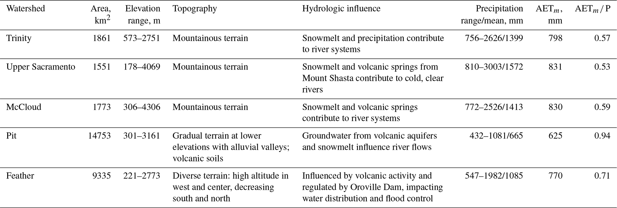
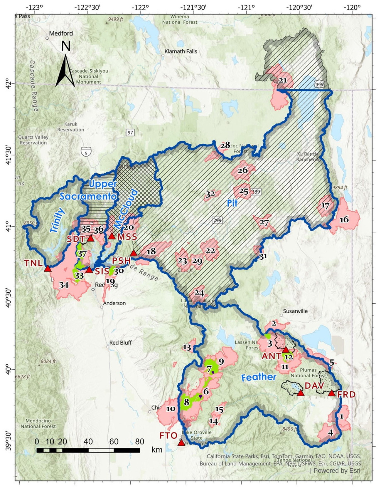
Figure 1Study area. The blue outlined watersheds are the five key water supply watersheds. Red triangles are sites with full natural flow (FNF) data, and shaded areas are the corresponding watersheds. The pink parts are areas showing the 37 large fires analyzed. The green and dark purple parts respectively indicate areas that burned twice and three times. Tables 1 and 2 list the information on FNF sites and large fires.
The study basins span a clear hydroclimatic gradient, which we quantify using a long-term aridity indicator (AET P) ranging from approximately 0.53–0.59 in wetter basins (Trinity, Upper Sacramento, and McCloud) to ∼ 0.94 in the relatively drier Pit basin, with Feather showing intermediate conditions (Table 1). The Trinity, McCloud, and Upper Sacramento River watersheds lie in Northern California's Klamath-Cascade region and share steep mountainous terrain, deep incised canyons, and pronounced elevation gradients that support dense mixed-conifer forests, primarily composed of Douglas-fir, ponderosa pine, white fir, and sugar pine. These areas receive substantial winter precipitation, with high-elevation snow accumulation driving spring runoff. Mount Shasta strongly influences the McCloud and Upper Sacramento, contributing snowmelt and volcanic springs to cold, perennial flows. The Pit watershed features volcanic soils and groundwater-fed baseflow, but receives less precipitation overall and has a drier climate as it descends into lower agricultural valleys. In contrast, the Feather watershed in the Sierra Nevada covers forested western ridges and drier eastern slopes that occupy the Sierra Nevada rain shadow. Its hydrology is regulated by both volcanic terrain and infrastructure such as Oroville Dam, which manages downstream water deliveries and flood control.
These watersheds experience a Mediterranean climate, characterized by wet, cold winters and long, dry summers. Precipitation occurs primarily between November and March, with significant snowfall at higher elevations. Annual precipitation varies from around 400 mm in the lower elevations of the Pit watershed to over 3000 mm at higher elevations in the Upper Sacramento watershed. Winter temperatures range from −5 to 9 °C, while summer temperatures range from 10 to 25 °C, depending on elevation (PRISM Climate Group, 2025).
2.2 Data
To analyze fire impacts, we used the historical fire-perimeter dataset from the Fire and Resource Assessment Program (FRAP) (https://www.fire.ca.gov/what-we-do/fire-resource-assessment-program, last access: 10 December 2025), focusing on 37 fires exceeding 10 000 acres between 1985 and 2020 (Table 2).
Table 2Information for 37 large fires in key water supply watersheds.
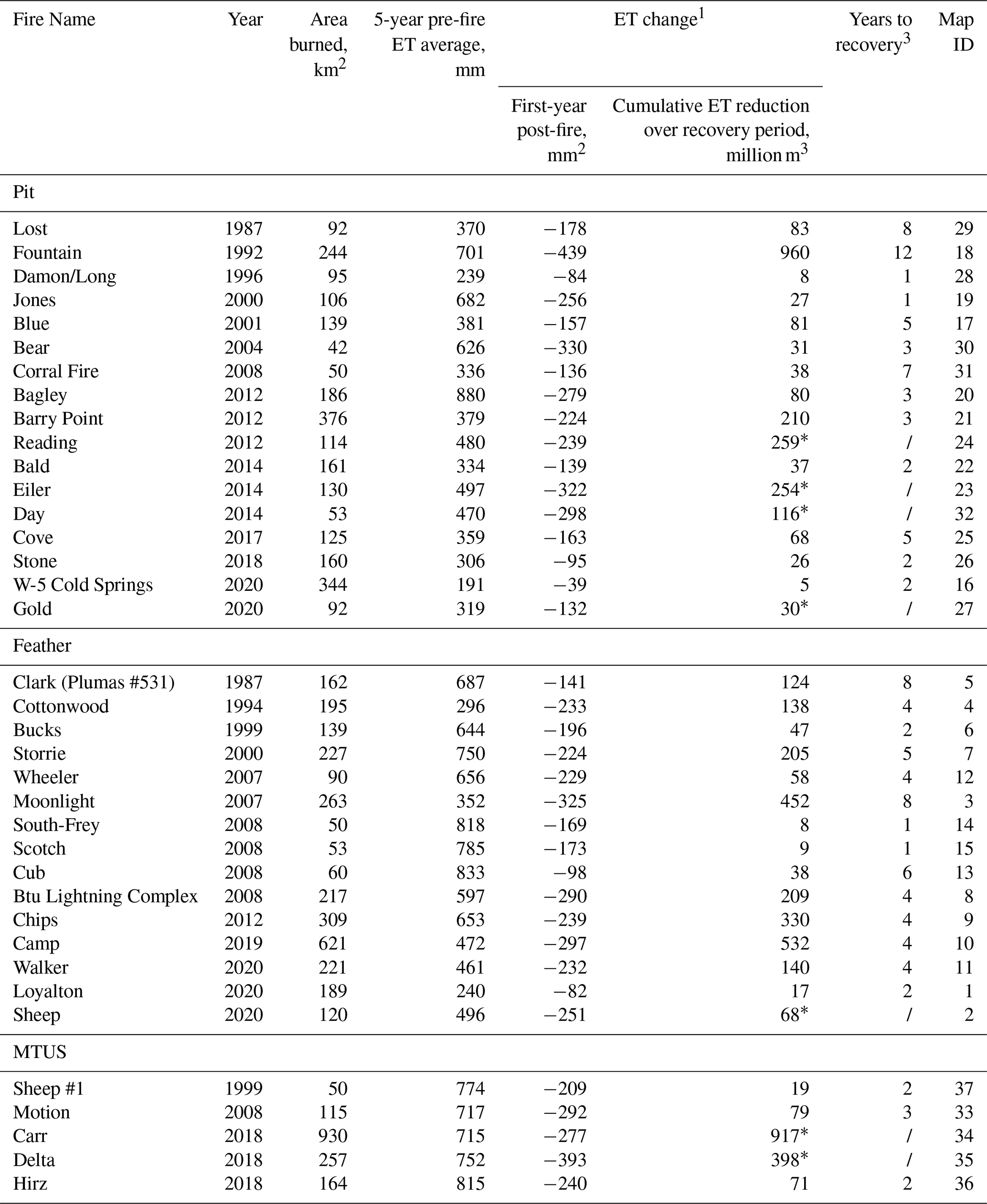
1 ET data is based on net ET reduction. 2 Minus indicates a reduction relative to 5-year pre-fire mean 3 Years to recovery was defined as the number of years after the fire until the mean annual ET equaled or exceeded 75 % of the pre-fire 5-year mean. /: ET recovery did not reach 75 % in the available years of data. * The mean annual ET did not reach 75 % of the pre-fire 5-year mean in the available years of data.
Given the overlapping fire boundaries and shared ecological characteristics, we combined the Trinity, Upper Sacramento, and McCloud watersheds into a unified area (MTUS) to analyze fire impacts at a broader scale while maintaining hydrologic relevance. The Center for Ecosystem Climate Solutions (CECS) (https://california-ecosystem-climate.solutions, last access: 10 December 2025) provides annual evapotranspiration (ET) products at 30 m spatial resolution across California. These ET estimates are derived from a Landsat-based empirical model that combines remotely sensed vegetation indices with climate variables and eddy-covariance flux-tower observations. Specifically, annual ET is estimated from relationships between Landsat-derived normalized difference vegetation index (NDVI) and measured ET at flux-tower sites distributed across California forests (Goulden and Bales, 2019; Guo et al., 2023; Chung et al., 2024).
Precipitation (P) was obtained from the PRISM climate dataset, which provides gridded daily precipitation at approximately 800 m spatial resolution. Annual precipitation totals were aggregated from daily PRISM data and resampled to match the 30 m ET grid (Roche et al., 2020). We also obtained monthly full natural flow (FNF) estimates from the California Data Exchange Center (CDEC) (https://cdec.water.ca.gov/index.html, last access: 10 December 2025). CDEC defines FNF (also termed “unimpaired runoff”) as the natural water production of a basin absent upstream diversions, storage regulation, and net basin imports/exports; FNF is calculated by adjusting gauged flows at the reporting location to account for upstream operations. We use CDEC FNF as the best available long-term unimpaired outflow estimate for these basins, while recognizing that uncertainty in the naturalization procedure and in upstream operation/diversion records can contribute to apparent water-balance residual structure. This dataset includes nine continuously monitored sites within key water-supply watersheds, spanning from 1985 to the 2023 water year (Table 3). Using California's digital elevation model (DEM) and the Watershed tool in ArcGIS Pro, we delineated the contributing area for each FNF site to ensure consistent spatial matching among P, ET, and FNF.
Table 3Information for CDEC FNF stations in key water supply watersheds.
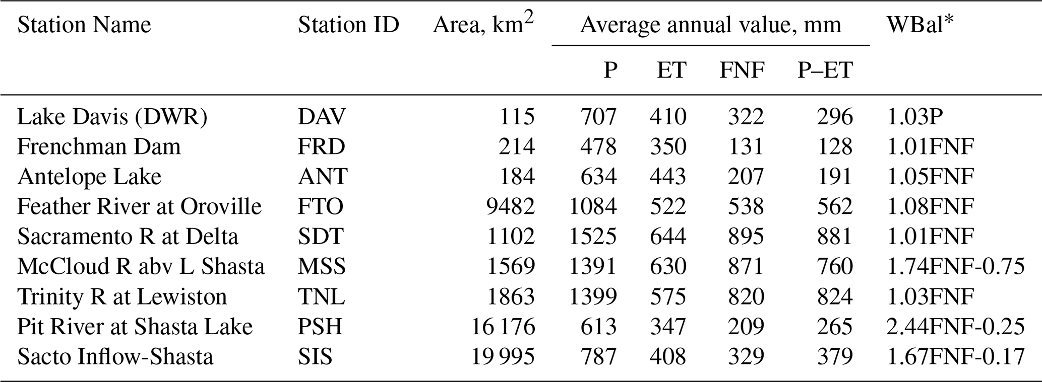
* Water-balance components were adjusted, with the number preceding “P” or “FNF” indicating the multiplier applied to the data.
2.3 Analysis
Quantifying ET reduction and recovery. We assessed the net ET response to wildfire by comparing burned and unburned areas before and after each fire. Areas within each watershed that have never experienced fire and that fall within a 500 m buffer surrounding each fire perimeter were defined as unburned areas. The 500 m buffer was selected to preserve environmental comparability between burned and reference areas while excluding fire-edge artifacts, consistent with unburned control buffer distances of 100 m to 1 km used in post-fire forest studies in the Sierra Nevada (Chamberlain et al., 2024). The net ET reduction in burned area was calculated as follows (Roche et al., 2020):
where ETburned, prefire and ETunburned, prefire represent the mean ET in the five years preceding a fire, and ETburned, postfire, ETunburned, postfire denote ET after the fire. All ET and P values are water-year aggregated (mean annual) quantities; the “first postfire year” refers to the first complete water year after the fire occurrence. When fewer than five pre-fire years were available, ET was averaged from 1985 until the year of the fire. This paired approach isolates the net disturbance signal by removing background climatic variability. For each watershed, we calculated the cumulative burned area and averaged ΔET over burned pixels to derive both per-area reduction (mm) and total volumetric change (km3). Net ET reductions at the watershed scale were derived as area-weighted aggregates of ET responses from individual fires within each basin. ET recovery was tracked annually following each fire, and the time required for ET to reach 75 % of the five-year pre-fire mean was used as the recovery benchmark. This fractional threshold, rather than full return, was adopted because post-fire ET rarely recovers completely in semi-arid and repeatedly burned systems, and 75 % falls within the 75 %–80 % range applied in CONUS-scale and Sierra Nevada post-fire ET studies (Collar et al., 2021; Ma et al., 2020). To provide a quantitative context for vegetation structure during the ET recovery process, we also examined the proportional composition of vegetation within the fire perimeter. Vegetation composition data were derived from the CECS dataset, comprising the proportions of trees, shrubs, herbaceous vegetation, and bare ground.
We also explored the impacts of burn severity on the ET reduction. Time series burn severity layers across the years when the wildfires occurred were obtained from the Monitoring Trends in Burn Severity (MTBS) dataset. For each fire perimeter, we calculated the fraction of high-severity burn area based on MTBS severity classifications. We then evaluated the relationship between this severity metric and the magnitude of first-year ET reduction across the analyzed fires.
Assessing wildfire impacts on runoff response. To evaluate how wildfires influence runoff generation in key water-supply watersheds, we examined the relationships among P, ET, and observed basin outflow (FNF) at the sub-basin scale. For each water year from 1985 to 2023, we used FRAP fire-perimeter data to calculate the annual proportion of burned area within each delineated sub-watershed. Corresponding annual P and ET values were obtained from CECS gridded datasets and area-averaged for each sub-watershed. Monthly FNF records from CDEC were aggregated to annual totals and matched to their upstream contributing areas. We then compared interannual variation in P, ET, and FNF for each sub-basin, focusing on whether reductions in ET, particularly in fire years, were associated with observable changes in FNF. We also evaluated potential lagged effects of wildfire by examining FNF anomalies one to three years after major fire events.
To evaluate potential precipitation uncertainty, basin-mean precipitation derived from PRISM was compared with an independent gridded precipitation dataset (TerraClimate) over the overlapping study period (Fig. S1).
Diagnosing wildfire-induced disruption to basin-scale water balance. To evaluate whether wildfire influences water-balance closure, we compared annual residuals (P–ET–FNF) between high-fire years and non-fire years. High-fire years were defined as those in which more than 3 % of the watershed area burned, with all remaining years classified as non-fire years. Published basin-scale studies have applied thresholds ranging from approximately 1 % to 5 % (Hallema et al., 2018; Beyene et al., 2021); our choice of 3 % lies within this range, and sensitivity analysis confirming robustness across alternative thresholds is provided in Fig. S2. A Welch's two-sample t-test was used to assess whether this difference reflects a systematic effect of wildfire on hydrologic closure.
To further assess basin-scale water balance, we compared annual P–ET with observed FNF for each sub-watershed. At annual (water-year) timescales, changes in basin storage (ΔS) are often smaller than the dominant flux terms, but they are not necessarily negligible, particularly following major disturbance. Accordingly, deviations between P–ET and FNF are interpreted as an “apparent non-closure residual”, R = P–ET–FNF, which may reflect a combination of ΔS and uncertainties or structural mismatches in P, ET, and/or FNF. For each site, we examined linear relationships among FNF, P, and P–ET. Where persistent discrepancies existed, we introduced simple diagnostic reconciliation parameters (multiplicative scaling and, where needed, an additive offset) to characterize whether the apparent residual structure was more consistent with a multiplicative bias (e.g., systematic under- or over-estimation) or an additive structural offset (e.g., drainage-area mismatch, persistent exchange fluxes, or non-zero ΔS aggregated at annual scale). Watersheds were grouped into categories such as: basins exhibiting minimal apparent non-closure; basins where a multiplicative term reduced the residual; and basins where both scaling and an intercept term were required. These parameters are used only for diagnostic interpretation of residual structure, not for calibration or modification of the underlying datasets.
3.1 Quantifying ET reduction and recovery
Wildfires caused substantial reductions in ET across burned areas, ranging from 40 to 440 mm yr−1, with the strongest suppression occurring in the first postfire year (Table 2; Fig. 2). ET gradually increased in subsequent years as vegetation recovered.
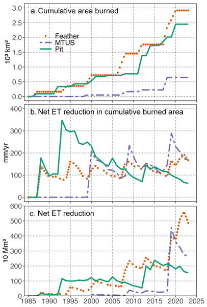
Following the 1987 Lost Fire in the Pit basin, ET in the 92 km−1 burned area declined by 177 mm in the first postfire year (16 million m3) and accumulated to 83 million m3over the eight years required for ET to return to 75 % of its prefire mean. The 1992 Fountain Fire, also in the Pit and characterized by high severity and a large burned extent (244 km2), produced a first-year ET reduction of 439 mm (107 million m3) and a cumulative reduction of 960 million m3before reaching the 75 % recovery threshold in year 12. In 1993, the combined effects of multiple fires resulted in a net ET reduction of 347 mm across burned areas in the Pit basin (Fig. S3). In the Feather basin, the 2007 Moonlight Fire burned 263 km2 and generated a first-year ET reduction of 325 mm (85 million m3). ET recovered to 75 % of its prefire value by year 8, yielding a cumulative loss of 452 million m3 (Fig. S4). The 2008 Motion Fire in MTUS caused a first-year reduction of 292 mm across 115 km2, corresponding to 33 million m3, and a cumulative impact of 79 million m3 over the three-year recovery period (Fig. S5). Cumulative losses ranged from tens to hundreds of millions of cubic meters before partial recovery was achieved. Across fires, the magnitude of first-year ET reduction increased with the fraction of high-severity burn area (Fig. S6). We assessed the vegetation composition and its changes within the perimeter of each fire, before and after the fire occurred(Figs. S3–5). Fires with prolonged ET suppression show sustained low tree fraction and elevated shrub/herbaceous/bare fractions over multiple years, whereas faster ET recovery coincides with more rapid increases in tree cover and declines in bare ground.
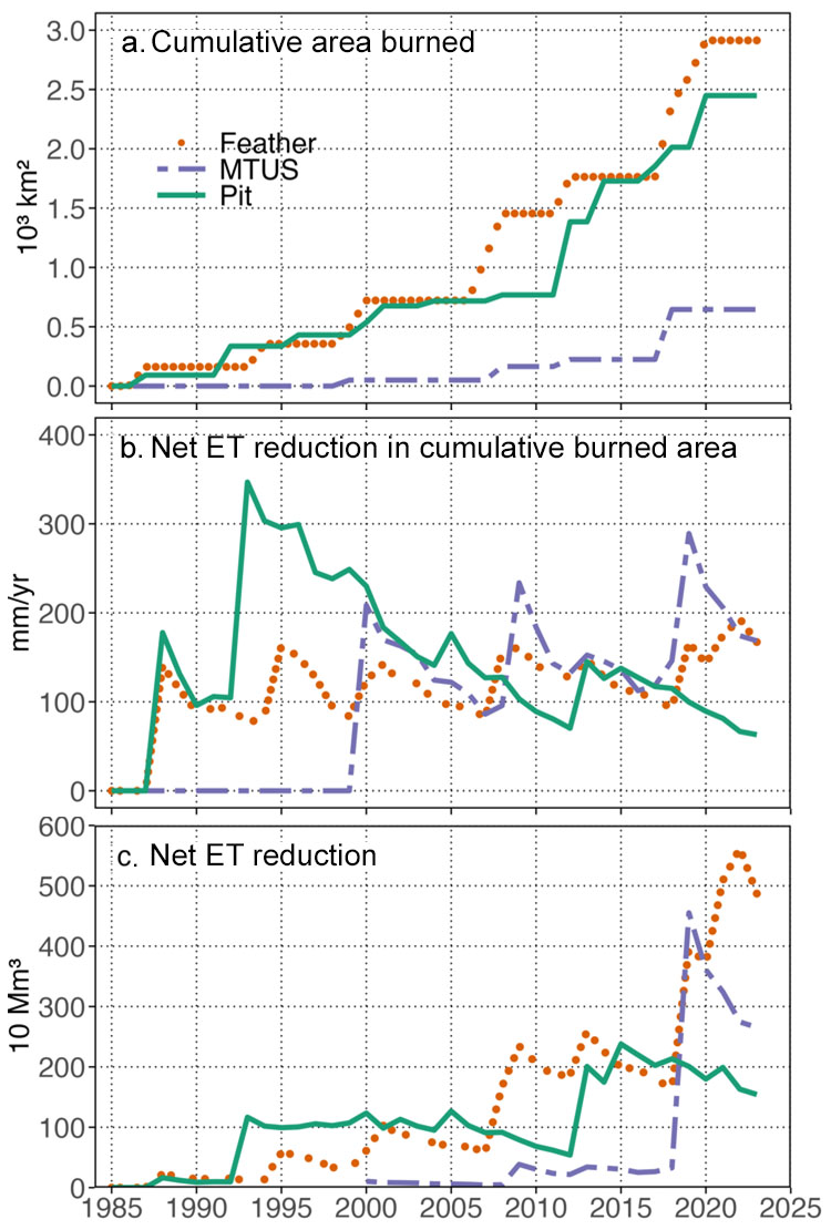
Figure 2Net evapotranspiration (ET) reductions and cumulative area burned in the three study areas. (a) Cumulative area burned (Table 2), (b) net annual ET reduction depth per unit area burned (See Fig. S3–5 for ET declines due to individual fire and increases with regrowth), and (c) net annual ET reduction volume resulting from fires in the three watersheds 1985–2023 (product of data on panels a and b).
Net ET reductions at the watershed scale were derived using area-weighted averages across all fires within each basin. In the Pit basin, repeated fires between 1993 and 2011 produced substantial interannual variability in net ET reduction, yet total reductions remained relatively stable until 2005, declining steadily thereafter (Fig. 2c). The 2012 fires burned 617 km2, producing a larger total ET reduction (147 million m3) despite a modest per-area reduction (75 mm, Fig. 2a–b). In the Feather basin, fluctuations in net ET reduction reflected both fire severity and the re-burning of previously affected areas. From 1988 to 2017, reductions ranged between 75 and 163 mm yr−1, generally lower than in the Pit (Fig. 2b). However, successive large fires between 2018 and 2020 sharply increased both burned area and basin-wide ET reduction. Although MTUS experienced fewer fires overall, its events were relatively severe. Three overlapping fires in 2018 burned 421 km2and led to a per-area ET reduction of 143 mm, equivalent to 420 million m3of total reduction. Among the three basins, the Feather experienced the largest individual fires (Table 2), whereas the Pit experienced the slowest rate of ET recovery.
Across the 37 fires examined, post-fire ET recovery occurred steadily with time, but repeated fires often prevented full return to prefire conditions. Because ET reductions were concentrated in the first postfire year, due to the use of annual ET, the second postfire year was considered the first year of recovery. On average, ET recovered 18 % in this first recovery year, with some fires (e.g., Loyalton) reaching 67 %. Most fires (31 of 37) reached 75 % recovery within an average of 3.9 years (range: 1–12 years). Fires that had not reached 75 % recovery by 2023 were excluded from this calculation.
At the watershed scale (Fig. 3), the Pit basin showed the slowest recovery, requiring an average of 10 years to reach 75 % of prefire ET, followed by MTUS (5 years) and Feather (4 years). Five years after a fire, ET had recovered to 69 % of prefire levels in the Pit, 75 % in MTUS, and 78 % in the Feather (Table 2). In the Feather basin, recovery was interrupted by large fires occurring in years 9 and 21, lowering ET sharply (by ∼ 100 mm), but subsequent recovery rates were faster than after the initial fire. Similar patterns of partial recovery followed by renewed suppression were observed in MTUS, where secondary fires occurred 11 years after initial burning.
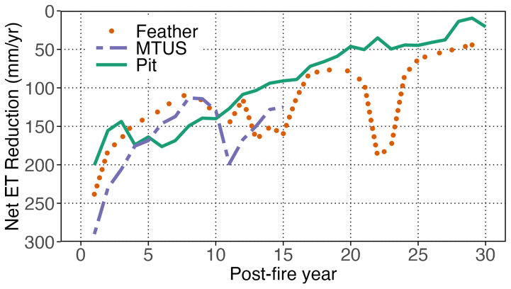
Figure 3Post-fire ET recovery. Post-fire evapotranspiration (ET) recovery trajectories were tracked over 30 years across three watersheds: Feather (orange dots), MTUS (purple dashed line), and Pit (green solid line). The y-axis shows net ET reduction (mm yr−1) relative to pre-fire conditions. Data reflect averaged changes across burned areas, with at least three fire events. While all three watersheds exhibit gradual ET recovery, the rate and magnitude vary, and Feather displays notable variability in later post-fire years.
3.2 Assessing wildfire impacts on basin outflow
At the sub-basin scale, evapotranspiration is influenced by wildfire, precipitation and temperature. Annual basin outflow, represented by observed full natural flow (FNF), remains primarily driven by precipitation, while variations in ET may contribute to smaller year-to-year differences in runoff through the basin water-balance relationship (Fig. 4). For example, although no fires occurred in the DAV region between 1985 and 2020, ET still exhibited fluctuations, indicating that regional climate variability played a substantial role (Fig. 4a). Between 1985 and 2023, two major declines in ET occurred in DAV. The first decline, from 1987 to 1992, involved a 17 % reduction in ET and coincided with sharp ET decreases in other basins, driven by low precipitation and corresponding reductions in basin outflow. The second notable decline occurred in 2022, when ET decreased by 20 % relative to the preceding five-year average during another dry year.
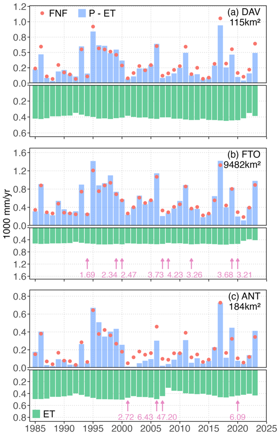
Figure 4Changes in precipitation, evapotranspiration, full natural flow, and burned area from 1985 to 2023 in the Feather basin. The changes in ET, P, P–ET and FNF over time for the sub-watersheds are shown. The pink arrows and labels indicate the year of fire and the percentage of burned area. The figures only show years where the area burned was greater than 1 % of the area of the watershed. Data for additional sites are in Supplementary Fig. S9.
This 2022 decline was synchronized across nearly all sub-watersheds in the Feather basin, particularly in areas overlapping with the 2020 North Complex and 2021 Dixie fires, where ET dropped sharply, by 58 % and 54 %, respectively, following extensive high-severity canopy loss (Fig. S7). The strong spatial coherence likely reflects the combined impacts of drought and the two large fires, which together produced a broad, contiguous burn footprint and reduced vegetation water use across the region. However, the modest increase in P in 2022 introduces uncertainty in interpreting the observed increase in basin outflow. The FTO station, which represents basin-wide outflow for the Feather, captured these variations (Fig. 4b). Although the Feather experienced frequent fires, the limited proportion of burned area prior to 2021 constrained fire impacts on whole-basin ET. The rapid ET declines observed in 2021 and 2022 were therefore likely dominated by the 2021 fire.
Across all basins, interannual P variation was strongly correlated with annual FNF, indicating that precipitation remains the dominant control on basin outflow. Because most fires affected only small fractions of sub-basin areas, ET reductions were generally insufficient to produce measurable changes in FNF at gauging stations, in part because most fires affected only small portions of the contributing watershed area and their hydrologic effects may be diluted when integrated across basin-scale runoff observations. A notable exception occurred in the ANT basin in 2007, where a fire burned 47 % of the basin area and reduced ET by 31 % (Fig. 4c). In the same year, P declined by 26 %, yet FNF decreased by only 10 %, suggesting that reduced ET partially offset the precipitation deficit. However, quantifying this compensatory effect requires information on subsurface storage changes, which were not available.
3.3 Diagnosing wildfire-induced disruption and water-balance closure across basins
To assess whether wildfire contributes to basin-scale water-balance discrepancies, we compared annual residuals of P–ET and full natural flow (P–ET–FNF) between high-fire years and non-fire years across all basins from 1985 to 2023. High-fire years were defined as years in which more than 3 % of the watershed area burned (n=13), while all remaining years were classified as non-fire years (n=54). High-fire years consistently exhibited more negative residuals, indicating that observed FNF exceeded expected P–ET to a greater degree during periods of extensive fire activity (Fig. S8). A Welch's two-sample t-test confirmed that the difference was statistically significant (, p=0.017), indicating that years with extensive fire activity are associated with more negative residuals relative to non-fire years across basins, for the first year of fire occurrence.
To further evaluate the nature of these discrepancies, we analyzed the relationships between FNF, P, and P–ET using annual data from nine study watersheds. Under ideal conditions, modeled P and ET should broadly reproduce observed runoff, resulting in similar temporal behavior between P–ET and FNF. In basins where ET remains stable and disturbance effects are limited, a near-linear relationship between P and FNF is expected, with data points clustering near the 1:1 line and a slope approaching unity. Deviations from this relationship represent the combined effects of transient storage variation, dataset uncertainty, and disturbance-related hydrologic responses. However, substantial deviations from this ideal behavior were observed, reflecting combined influences of data uncertainties, basin heterogeneity, and disturbance legacies (Roche et al., 2022).
To diagnose the sources of apparent non-closure, we evaluated basin-specific diagnostic scaling and intercept terms applied to P or FNF to summarize the residual structure. Watersheds were grouped into three categories based on closure behavior. First, for well-balanced basins with good alignment between P–ET and FNF, such as those in the upper Feather watershed (Fig. 5a, b), FNF vs. P and P–ET vs. P exhibited consistent relationships, and only minor proportional adjustment (e.g., 1.01 scaling of FNF in FRD) was needed for P–ET–FNF ≈ 0. Second, in basins where FNF > P–ET (e.g., DAV), the residual likely reflects a combination of factors, including precipitation uncertainty, potential groundwater or baseflow changes, and other subsurface flow processes. Multiplying P by 1.03 reduced the apparent residual to near zero, consistent with previous evidence that gridded precipitation products may underestimate totals in complex mountainous terrain. Third, in other basins, P–ET > FNF, indicating a persistent positive residual. Applying a multiplicative diagnostic term to FNF reduced this residual; for example, in FTO, a small scaling reduced the residual to 132 mm (Fig. 5c).
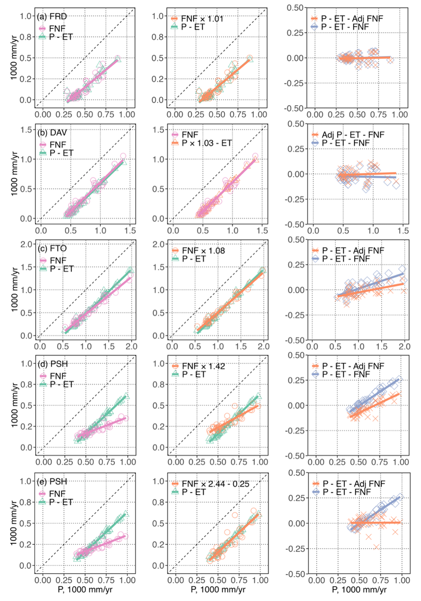
Figure 5Water balance analysis of representative watersheds. Shown are unadjusted annual water balance constituent discharge (FNF) and precipitation minus evapotranspiration (P–ET) versus annual precipitation (P). Also, adjust the FNF or P values (with one or two parameters) to improve the agreement between P–ET and FNF. The dashed diagonal line is a 1:1 line. Water balance residuals (P–ET-FNF) using unadjusted and adjusted components. Data for additional sites is in Supplementary Figs. S10 and S11.
For several basins (e.g., PSH, MSS, SIS), large residuals persisted even after applying a multiplicative term, and crossing regression patterns indicated that an additive offset was also needed. Introducing an intercept term provides a simple diagnostic representation of an additive residual component (e.g., structural mismatch, persistent exchange fluxes, or aggregated non-zero ΔS at annual scale). With both scaling and an intercept term, residuals were reduced to within 50 mm (Figs. 5d, e; S10), indicating that a two-parameter form better summarizes the observed residual structure in these basins.
Overall, this basin-level diagnosis demonstrates that deviations from closure stem from a combination of disturbance-induced hydrologic shifts, input-data biases, and structural measurement errors. Identifying and classifying these imbalances enables clearer interpretation of hydrologic responses to wildfire and improves the reliability of regional water-balance assessments.
Understanding how wildfires alter ET, basin outflow (FNF), and overall water balance is essential for diagnosing watershed resilience and supporting adaptive water-resource management in fire-prone landscapes. This study contributes new insights into (1) the magnitude and variability of ET reduction and recovery following wildfire of different extent and severity, (2) the extent to which fire-induced ET suppression influences observed outflow, and (3) the spatial heterogeneity and diagnostic interpretation of water-balance closure across multiple watersheds. Our multi-basin, post-fire hydrologic assessment highlights the need to reconcile spatial patterns, disturbance history, and observational uncertainty to better characterize watershed-scale impacts.
4.1 Determinants of postfire ET suppression and recovery patterns
Postfire reductions in ET were largely controlled by burn severity and burned area (Fig. S6), producing first-year unit-area losses of 100 to 250 mm yr−1, consistent with canopy combustion, loss of transpiring leaf area, and reductions in soil water retention (Mappin et al., 2003; Clemente et al., 2005; Nolan et al., 2014; Roche et al., 2018; Baur et al., 2024). High-severity events such as the 1992 fires in the Pit watershed (242 mm ET loss over 244 km2) and the 2018 fires in the MTUS (143 mm over 421 km2) illustrate this strong suppression (Fig. S6), and align with previous findings that high-severity burns in the Sierra Nevada produce early ET losses around 265 mm, with moderate-severity burns reducing ET by 150 to 200 mm over multiple years and requiring more than 15 years for full recovery in severely affected areas (Roche et al., 2020; Ma et al., 2020).
Recovery trajectories varied across basins and were influenced by climatic water availability and disturbance history, and coinciding with shifts in postfire vegetation composition (Figs. S3–5). Feather and MTUS showed faster recovery, returning to 75 % of prefire ET within four to five years, supported by favorable moisture conditions and rapid regrowth of fire-adapted shrubs. Pit, with a drier climate and repeated high-severity fires, recovered more slowly, reaching only 69 % of prefire ET by year five and requiring approximately ten years to meet the 75 % threshold. These patterns are consistent with hydrologic stress associated with drought and persistent soil-moisture deficits (Silveiro et al., 2024). Across the 37 fires, 31 reached 75 % recovery within an average of 3.9 years, although several remained below this threshold by 2023, underscoring the coincidence with postfire vegetation structural recovery pathways and composition shifts (Figs. S3–5). Shrub communities frequently resprouted quickly, but long-term ET recovery depended on tree canopy regeneration, and surviving conifers may experience long-term physiological impairment that limits transpiration (Niccoli et al., 2023).
Vegetation composition patterns derived from CECS datasets further highlight the central role of postfire structural change in governing ET recovery (Figs. S3–5). In high-severity burns such as the 2007 Moonlight fire (Fig. S4e), ET declined sharply and remained suppressed as shrubs and herbaceous cover increased relative to trees. A similar trajectory occurred in the Scotch fire footprint (Fig. S4j), where the 2008 burn was followed by reburning during the 2020–2021 North Complex event, illustrating how repeated disturbance can constrain canopy re-establishment and prolong low-ET states. Even modest increases in low-stature vegetation combined with delayed tree regrowth contributed to sustained watershed-scale ET suppression extending more than a decade in some areas.
Climatic and ecological heterogeneity across basins further shaped cumulative responses. MTUS, despite having the smallest burned area, experienced the highest total ET loss during the 2018 fire (420 million m3), while Feather, which accumulated the largest burned area from 1985 to 2022, exhibited pronounced increases in total ET loss after successive fires between 2018 and 2022. These patterns emphasize that repeated disturbance is a major constraint on hydrologic recovery and that forests with complex canopy structure, functional diversity, and high ecological elasticity tend to recover more rapidly. In contrast, it has been suggested that ecosystems such as the Russian River watershed showed limited ET response, likely due to deep soils, Mediterranean climate, and buffering from subsurface storage and fire-adapted vegetation (Newcomer et al., 2023). Postfire soil hydrophobicity may also suppress ET by reducing infiltration and enhancing overland flow, a mechanism more relevant in coarse-textured or shallow volcanic soils such as in the Pit basin (Huffman et al., 2001; Boisramé et al., 2019).
Taken together, our results show that the magnitude of initial ET loss is controlled by burn severity and burned area, the pace of recovery is governed by vegetation regrowth pathways and moisture availability, and long-term suppression arises from disturbance recurrence. These factors jointly explain the heterogeneous ET responses observed across California's water-supply basins and provide the ecological basis for interpreting subsequent impacts on basin outflow and water-balance closure.
4.2 Drivers of postfire runoff response
Although interannual precipitation variability remains the dominant driver of runoff patterns across most basins, our results suggest that postfire reductions in ET may partially offset precipitation declines, particularly in high-severity burn areas. In most cases, runoff closely tracked precipitation trends, while ET fluctuated more moderately. However, the ANT basin illustrates a potential compensatory mechanism. After a 2007 fire that reduced ET by 31 %, runoff declined by only 10 % despite 26 % lower annual precipitation. This divergence suggests that suppressed ET may enhance water availability for basin outflow (FNF) under certain conditions. Mechanistically, fire-induced canopy loss and root mortality reduce transpiration and interception (Ice et al., 2004; Ma et al., 2020), while soil water repellency can inhibit infiltration and promote surface runoff (Shakesby and Doerr, 2006; Pradhan and Floyd, 2021). Together, these processes shift hydrologic partitioning toward runoff, particularly in water-limited systems where vegetation loss is extensive (Boisramé et al., 2019; Bart et al., 2021; Guzmán-Rojo et al., 2024).
However, such effects were not consistently detectable across all basins due to scale and context. Most fires affected limited portions of each watershed, limiting their measurable hydrologic impact at the basin scale. Because full natural flow (FNF) observations integrate hydrologic responses across the entire watershed, localized ET reductions within burned areas may be diluted when aggregated to the basin outlet. Consequently, wildfire-induced changes in evapotranspiration may not produce detectable runoff signals unless a substantial fraction of the watershed is burned. Consistent with other studies, significant runoff responses typically emerge only when ≥ 20 %–30 % of a watershed is burned (Wine and Cadol, 2016; Newcomer et al., 2023). Additionally, topographic complexity, vegetation recovery rates, and subsurface storage can modulate responses, making it difficult to isolate ET impacts (Kinoshita and Hogue, 2011; Wilder and Kinoshita, 2022). For example, in the Feather basin, postfire ET dropped sharply in 2022, but concurrent increases in precipitation obscured runoff attribution. Limited spatial coverage of stream gauges and ET monitoring further hampers inference, especially at sub-basin scales. While remote sensing has improved ET estimation (Poon and Kinoshita, 2018; Lahmers et al., 2025), establishing causal links between ET reduction and runoff response remains difficult without high-resolution hydrometeorological networks. These challenges underscore the importance of spatial scale, burn extent, and observational capacity in understanding postfire hydrologic responses. This scale mismatch between burned-area extent, spatially aggregated ET estimates, and basin-integrated runoff observations introduces an important limitation for interpreting weak runoff responses, particularly when fires affect only small or spatially fragmented portions of the watershed.
4.3 Diagnosing postfire water-balance non-closure and residual structure
Wildfire disturbance emerged as an important correlate of deviations from apparent annual water-balance closure across California's major watersheds. Fire years consistently exhibited more negative residuals (P–ET–FNF), indicating that observed basin outflow (FNF) exceeded P–ET to a greater degree during and immediately after disturbance. Because the annual residual reflects the combined influence of ΔS and uncertainties or structural mismatches in P, ET, and FNF, these results indicate that wildfire years are associated with systematic shifts in the residual structure rather than implying a single underlying mechanism. Likely mechanisms include reduced canopy interception, increased overland and subsurface flow, accelerated snowmelt, and postfire changes in infiltration capacity. These findings are consistent with earlier plot- and catchment-scale observations showing that fire simplifies canopy structure and redistributes water fluxes, often producing a transient “hydrologic release” followed by delayed recovery (Kinoshita and Hogue, 2015; Williams et al., 2022).
However, disturbance alone cannot explain the full range of discrepancies among basins. Even under non-disturbed conditions, achieving water-balance closure across California's heterogeneous landscapes requires careful interpretation and basin-specific adjustment strategies. Climatic gradients, lithologic differences, and differences in the degree of upstream regulation (which affects uncertainty in FNF naturalization) contribute to strong spatial heterogeneity in the relationship between simulated (P–ET) and observed (FNF) fluxes. Our diagnostic framework categorized nine sub-basins into three closure types, each reflecting distinct physical and measurement characteristics.
In contrast, the DAV watershed exhibited FNF consistently exceeding P–ET, which is unlikely due to enhanced runoff generation given consistent ET simulation methods across basins. Instead, this discrepancy may reflect precipitation uncertainty, particularly given the potential for interpolation error in complex mountainous terrain. Comparison with an independent precipitation dataset shows broadly consistent basin-scale precipitation patterns but modest differences in some years (Fig. S1), suggesting that precipitation uncertainty may contribute to the observed imbalance. A modest 3 % increase in the gridded precipitation substantially reduced residuals, aligning with prior findings that sparse station density and complex terrain in California's mountains often lead to interpolation errors (Avanzi et al., 2020; Safeeq et al., 2021; Roche et al., 2022). Orographic and localized rainfall patterns, common in such regions, may further exacerbate this issue (Avanzi et al., 2020). The DAV case underscores that seemingly excessive FNF may reflect incomplete precipitation inputs, emphasizing the need for finer-resolution meteorological data and improved validation.
In other basins (e.g., FTO, ANT, TNL, SDT), P–ET exceeded FNF, suggesting that FNF observations may underestimate actual water yield. This systematic underestimation likely results from subsurface bypass flow, vertical seepage, or unmeasured groundwater discharge (Avanzi et al., 2020; Roche et al., 2022). Permeable lithology, faulting, and uncertainties associated with upstream reservoir operations involved in the naturalization of full natural flow (FNF) estimates may further obscure true basin outflow (Safeeq et al., 2021; Roche et al., 2022). Applying a multiplicative diagnostic term reduced residuals to within 100–150 mm, consistent with the presence of systematic discrepancies in the FNF–P–ET relationship in these basins.
However, in PSH, MSS, and SIS, large residuals persisted even after proportional adjustment, and regression lines exhibited crossing patterns, signaling structural bias beyond simple scaling errors. Potential causes include gauge misalignment, cross-sectional changes, or sensor drift (Safeeq et al., 2021; Roche et al., 2022). Here, we applied a dual-parameter diagnostic form (scaling + intercept), which reduced residuals to within 50 mm. This indicates that in basins where residuals include both multiplicative and additive components, a two-parameter form provides a more informative summary of the apparent non-closure structure, although it does not uniquely identify the underlying physical processes.
Achieving water-balance closure across heterogeneous basins requires context-specific correction strategies, as no single method universally resolves discrepancies. Proportional adjustments are suitable for diagnosing fluxes where systematic underestimation dominates and temporal patterns are coherent, while dual-parameter approaches are more appropriate in basins with structural biases or complex error signatures. Critically, identifying the underlying sources of imbalance, rather than enforcing statistical fit, enhances the physical credibility of hydrologic assessments under multi-source uncertainty. Nonetheless, even error-informed corrections face practical limitations. P and ET inputs often rely on spatial interpolation or remotely sensed products, which may fail to capture localized variability in regions with complex terrain or sparse monitoring infrastructure. Similarly, full natural flow (FNF) estimates can be compromised by stream-gauge placement and design, particularly when gauges do not align with actual contributing areas, resulting in long-term structural bias. In addition, many watersheds may be affected by data gaps or uncertainties in the naturalization procedure used to estimate full natural flow (FNF), including incomplete records of reservoir operations, diversions, and inter-basin transfers. Such uncertainties can propagate into the reconstructed unimpaired flow series and complicate attribution of observed water-balance residuals. These constraints reduce the generalizability of empirical corrections and highlight the need for next-generation hydrologic models that couple high-resolution observations, detailed management records, and process-based representations of watershed behavior.
4.4 Implications for hydrologic modeling and water resource management
Although substantial progress has been made in understanding post-wildfire hydrologic responses (e.g., Goeking and Tarboton, 2020; Hallema et al., 2018; Beyene et al., 2021), this study integrated long-term satellite ET, precipitation, and full natural flow records to more directly quantify the disruption of wildfire to the balance among precipitation, ET, and basin outflow. The systematic deviations between modeled (P–ET) and observed basin outflow (FNF) during fire years show that disturbance fundamentally alters basin water budgets. Postfire ET suppression, delayed vegetation recovery, and shifts in infiltration or snowmelt processes create hydrologic conditions that steady-state models cannot represent. These findings highlight the need for disturbance-sensitive model components, including flexible ET recovery functions, representations of vegetation structural change, and nonlinear thresholds linking burn extent to runoff response.
At the basin-integration scale, wildfire effects interact with substantial observational uncertainties. Persistent negative P–ET–FNF residuals reflect a combination of disturbance-driven hydrologic responses, transient storage variations, and observational uncertainties such as precipitation underestimation, gauge bias, heterogeneous subsurface pathways, and or delayed subsurface drainage. No single correction approach ensures water-balance closure across diverse terrain; instead, models should pair physically based process representations with diagnostic calibration schemes that explicitly account for disturbance and measurement uncertainty. Such strategies will reduce misinterpretation of postfire hydrologic anomalies and improve runoff estimation in complex landscapes.
From a management perspective, incorporating fire history, burn severity, and ET recovery patterns into reservoir operations and water-allocation planning is essential for avoiding overestimation of water availability or underestimation of infrastructure vulnerability. Ultimately, reliable water-balance assessments in fire-prone regions will require integrating high-resolution disturbance mapping, continuous ET and precipitation monitoring, and process-based ecohydrologic modeling to anticipate watershed responses to wildfire, drought, and climate variability and support resilient water-resource governance.
Large wildfires impose short-term but measurable disruptions to evapotranspiration, basin outflow, and water-balance closure in California's major water-supply watersheds. High-severity burns suppressed ET by 100–250 mm in the first year, with recovery rates influenced by moisture availability and disturbance recurrence, and coinciding with shifts in postfire vegetation composition. Although precipitation remained the primary control on basin outflow, ET losses occasionally moderated drought-year flow declines in heavily burned basins, indicating a limited compensatory effect. Fire years also produced systematically negative P–ET–FNF residuals, revealing that wildfire amplifies existing closure errors associated with precipitation uncertainty and stream-gauge bias. Together, these results show that wildfire acts as a hydrologic shock that alters water partitioning and exposes structural uncertainties in observational datasets. Incorporating disturbance history, ET-recovery patterns, and closure diagnostics will improve postfire flow prediction and strengthen water-resource planning under rising fire activity.
The wildfire perimeter dataset is publicly available through the California Fire and Resource Assessment Program (FRAP). Full natural flow (FNF) records are publicly available from the California Data Exchange Center (CDEC). The evapotranspiration and precipitation datasets generated by the Center for Ecosystem Climate Solutions (CECS) were previously publicly accessible; access is currently provided upon request from CECS.
Derived watershed-scale metrics and analysis scripts are available from the corresponding author upon reasonable request.
The supplement related to this article is available online at https://doi.org/10.5194/hess-30-4367-2026-supplement.
Conceptualization: ZH, RB. Data curation: ZH, MG, HG. Formal analysis: ZH, HG. Methodology: ZH, HG, RB. Project administration: RB. Resources: RB, MG. Software: ZH, HG. Supervision: RB. Validation: ZH. Visualization: ZH. Writing – original draft: ZH. Writing – review and editing: all authors.
The contact author has declared that none of the authors has any competing interests.
Publisher's note: Copernicus Publications remains neutral with regard to jurisdictional claims made in the text, published maps, institutional affiliations, or any other geographical representation in this paper. The authors bear the ultimate responsibility for providing appropriate place names. Views expressed in the text are those of the authors and do not necessarily reflect the views of the publisher.
We thank the Center for Ecosystem Climate Solutions (CECS) for providing the datasets used in this study, which was supported by the California Climate Investments program through the Strategic Growth Council (grant no. CCR20021).
This paper was edited by Mariano Moreno de las Heras and reviewed by Horia Olariu and one anonymous referee.
Abatzoglou, J. T. and Williams, A. P.: Impact of anthropogenic climate change on wildfire across western US forests, P. Natl. Acad. Sci. USA, 113, 11770–11775, https://doi.org/10.1073/pnas.1607171113, 2016.
Avanzi, F., Rungee, J., Maurer, T., Bales, R., Ma, Q., Glaser, S., and Conklin, M.: Climate elasticity of evapotranspiration shifts the water balance of Mediterranean climates during multi-year droughts, Hydrol. Earth Syst. Sci., 24, 4317–4337, https://doi.org/10.5194/hess-24-4317-2020, 2020.
Bart, R. R., Ray, R. L., Conklin, M. H., Safeeq, M., Saksa, P. C., Tague, C. L., and Bales, R. C.: Assessing the effects of forest biomass reductions on forest health and streamflow, Hydrol. Process., 35, e14114, https://doi.org/10.1002/hyp.14114, 2021.
Baur, M. J., Friend, A. D., and Pellegrini, A. F. A.: Widespread and systematic effects of fire on plant–soil water relations, Nat. Geosci., 17, 1115–1120, https://doi.org/10.1038/s41561-024-01563-6, 2024.
Beyene, M. T., Leibowitz, S. G., and Pennino, M. J.: Parsing weather variability and wildfire effects on the post-fire changes in daily stream flows: a quantile-based statistical approach and its application, Water Resour. Res., 57, e2020WR028029, https://doi.org/10.1029/2020WR028029, 2021.
Boisramé, G., Thompson, S., Collins, B., and Stephens, S.: Managed wildfire effects on forest resilience and water in the Sierra Nevada, Ecosystems, 20, 717–732, https://doi.org/10.1007/s10021-016-0048-1, 2017.
Boisramé, G. F. S., Thompson, S. E., Tague, C. L., and Stephens, S. L.: Restoring a natural fire regime alters the water balance of a Sierra Nevada catchment, Water Resour. Res., 55, 5751–5769, https://doi.org/10.1029/2018WR024098, 2019.
California Department of Water Resources: California Water Plan Update 2023, Bulletin 160, California Department of Water Resources, Sacramento, CA, https://water.ca.gov/Programs/California-Water-Plan/Update-2023 (last access: 10 December 2025), 2023.
Chamberlain, C. P., Bartl-Geller, B. N., Cansler, C. A., North, M. P., Meyer, M. D., van Wagtendonk, L., Redford, H. E., and Kane, V. R.: When do contemporary wildfires restore forest structures in the Sierra Nevada?, Fire Ecol., 20, 91, https://doi.org/10.1186/s42408-024-00324-5, 2024.
Chung, M. G., Guo, H., Nyelele, C., Egoh, B. N., Goulden, M. L., Keske, C. M., and Bales, R. C.: Valuation of forest-management and wildfire disturbance on water and carbon fluxes in mountain headwaters, Ecohydrology, 17, e2642, https://doi.org/10.1002/eco.2642, 2024.
Clemente, A. S., Rego, F. C., and Correia, O. A.: Growth, water relations and photosynthesis of seedlings and resprouts after fire, Acta Oecol., 27, 233–243, https://doi.org/10.1016/j.actao.2005.01.005, 2005.
Collar, N. M., Saxe, S., Rust, A. J., and Hogue, T. S.: A CONUS-scale study of wildfire and evapotranspiration: spatial and temporal response and controlling factors, J. Hydrol., 603, 127162, https://doi.org/10.1016/j.jhydrol.2021.127162, 2021.
Collar, N. M., Ebel, B. A., Saxe, S., Rust, A. J., and Hogue, T. S.: Implications of fire-induced evapotranspiration shifts for recharge-runoff generation and vegetation conversion in the western United States, J. Hydrol., 621, 129646, https://doi.org/10.1016/j.jhydrol.2023.129646, 2023.
Goeking, S. A. and Tarboton, D. G.: Forests and water yield: a synthesis of disturbance effects on streamflow and snowpack in western coniferous forests, J. Forest., 118, 172–192, https://doi.org/10.1093/jofore/fvz069, 2020.
Goulden, M. L. and Bales, R. C.: California forest die-off linked to multi-year deep soil drying in 2012–2015 drought, Nat. Geosci., 12, 632–637, https://doi.org/10.1038/s41561-019-0388-5, 2019.
Guo, H., Goulden, M., Chung, M. G., Nyelele, C., Egoh, B., Keske, C., Conklin, M., and Bales, R.: Valuing the benefits of forest restoration on enhancing hydropower and water supply in California's Sierra Nevada, Sci. Total Environ., 876, 162836, https://doi.org/10.1016/j.scitotenv.2023.162836, 2023.
Guo, H., Goulden, M., Chung, M. G., Xu, Q., Nyelele, C., Guo, W., Egoh, B., Conklin, M., Keske, C., Safeeq, M., and Bales, R.: Valuing co-benefits of forest fuels treatment for reducing wildfire risk in California's Sierra Nevada, Sci. Total Environ., 1001, 180487, https://doi.org/10.1016/j.scitotenv.2025.180487, 2025.
Guzmán-Rojo, M., Fernandez, J., d'Abzac, P., and Huysmans, M.: Impacts of wildfires on groundwater recharge: a comprehensive analysis of processes, methodological challenges, and research opportunities, Water, 16, 2562, https://doi.org/10.3390/w16182562, 2024.
Hallema, D. W., Sun, G., Bladon, K. D., Norman, S. P., Caldwell, P. V., Liu, Y., and McNulty, S. G.: Regional patterns of postwildfire streamflow response in the western United States: the importance of scale-specific connectivity, Hydrol. Process., 31, 2582–2598, https://doi.org/10.1002/hyp.11208, 2017.
Hallema, D. W., Sun, G., Caldwell, P. V., Norman, S. P., Cohen, E. C., Liu, Y., Bladon, K. D., and McNulty, S. G.: Burned forests impact water supplies, Nat. Commun., 9, 1307, https://doi.org/10.1038/s41467-018-03735-6, 2018.
Huffman, E. L., MacDonald, L. H., and Stednick, J. D.: Strength and persistence of fire-induced soil hydrophobicity under ponderosa and lodgepole pine, Colorado Front Range, Hydrol. Process., 15, 2877–2892, https://doi.org/10.1002/hyp.379, 2001.
Ice, G. G., Neary, D. G., and Adams, P. W.: Effects of wildfire on soils and watershed processes, J. Forest., 102, 16–20, https://doi.org/10.1093/jof/102.6.16, 2004.
Keeley, J. E. and Syphard, A. D.: Climate change and future fire regimes: examples from California, Geosciences, 6, 37, https://doi.org/10.3390/geosciences6030037, 2016.
Kinoshita, A. M. and Hogue, T. S.: Spatial and temporal controls on post-fire hydrologic recovery in Southern California watersheds, Catena, 87, 240–252, https://doi.org/10.1016/j.catena.2011.06.005, 2011.
Kinoshita, A. M. and Hogue, T. S.: Increased dry season water yield in burned watersheds in Southern California, Environ. Res. Lett., 10, 014003, https://doi.org/10.1088/1748-9326/10/1/014003, 2015.
Lahmers, T. M., Kumar, S. V., Ahmad, S. K., Holmes, T., Getirana, A., Orland, E., Locke, K., Biswas, N. K., Nie, W., Pflug, J., Whitney, K., Anderson, M., and Yang, Y.: An observation-driven framework for modeling post-fire hydrologic response: evaluation for two central California case studies, Water Resour. Res., 61, e2023WR036582, https://doi.org/10.1029/2023WR036582, 2025.
Ma, Q., Bales, R. C., Rungee, J., Conklin, M. H., Collins, B. M., and Goulden, M. L.: Wildfire controls on evapotranspiration in California's Sierra Nevada, J. Hydrol., 590, 125364, https://doi.org/10.1016/j.jhydrol.2020.125364, 2020.
Mappin, K. A., Pate, J. S., and Bell, T. L.: Productivity and water relations of burnt and long-unburnt semi-arid shrubland in Western Australia, Plant Soil, 257, 321–340, https://doi.org/10.1023/A:1027349501441, 2003.
Miller, J. D. and Safford, H.: Trends in wildfire severity: 1984 to 2010 in the Sierra Nevada, Modoc Plateau, and southern Cascades, California, USA, Fire Ecol., 8, 41–57, https://doi.org/10.4996/fireecology.0803041, 2012.
Newcomer, M. E., Underwood, J., Murphy, S. F., Ulrich, C., Schram, T., Maples, S. R., Peña, J., Siirila-Woodburn, E. R., Trotta, M., Jasperse, J., Seymour, D., and Hubbard, S. S.: Prolonged drought in a northern California coastal region suppresses wildfire impacts on hydrology, Water Resour. Res., 59, e2022WR034206, https://doi.org/10.1029/2022WR034206, 2023.
Niccoli, F., Pacheco-Solana, A., Delzon, S., Kabala, J. P., Asgharinia, S., Castaldi, S., Valentini, R., and Battipaglia, G.: Effects of wildfire on growth, transpiration and hydraulic properties of Pinus pinaster Aiton forest, Dendrochronologia, 79, 126086, https://doi.org/10.1016/j.dendro.2023.126086, 2023.
Nolan, R. H., Lane, P. N. J., Benyon, R. G., Bradstock, R. A., and Mitchell, P. J.: Changes in evapotranspiration following wildfire in resprouting eucalypt forests, Ecohydrology, 7, 1363–1377, https://doi.org/10.1002/eco.1463, 2014.
Paul, M. J., LeDuc, S. D., Lassiter, M. G., Moorhead, L. C., Noyes, P. D., and Leibowitz, S. G.: Wildfire induces changes in receiving waters: a review with considerations for water quality management, Water Resour. Res., 58, e2021WR030699, https://doi.org/10.1029/2021WR030699, 2022.
Poon, P. K. and Kinoshita, A. M.: Estimating evapotranspiration in a post-fire environment using remote sensing and machine learning, Remote Sens., 10, 1728, https://doi.org/10.3390/rs10111728, 2018.
Pradhan, N. R. and Floyd, I.: Event based post-fire hydrological modeling of the upper Arroyo Seco watershed in southern California, Water, 13, 2303, https://doi.org/10.3390/w13162303, 2021.
PRISM Climate Group: PRISM climate data, Oregon State University [data set], https://prism.oregonstate.edu (last access: 10 December 2025), 2025.
Quesnel Seipp, K., Maurer, T., Elias, M., Saksa, P., Keske, C., Oleson, K., Egoh, B., Cleveland, R., Nyelele, C., Goncalves, N., Hemes, K., Wyrsch, P., Lewis, D., Chung, M. G., Guo, H., Conklin, M., and Bales, R.: A multi-benefit framework for funding forest management in fire-driven ecosystems across the Western U.S., J. Environ. Manage., 344, 118270, https://doi.org/10.1016/j.jenvman.2023.118270, 2023.
Robinne, F.-N., Hallema, D. W., Bladon, K. D., Flannigan, M. D., Boisramé, G., Bréthaut, C. M., Doerr, S. H., Di Baldassarre, G., Gallagher, L. A., Hohner, A. K., Khan, S. J., Kinoshita, A. M., Mordecai, R., Nunes, J. P., Nyman, P., Santín, C., Sheridan, G., Stoof, C. R., Thompson, M. P., Waddington, J. M., and Wei, Y.: Scientists' warning on extreme wildfire risks to water supply, Hydrol. Process., 35, e14086, https://doi.org/10.1002/hyp.14086, 2021.
Roche, J. W., Goulden, M. L., and Bales, R. C.: Estimating evapotranspiration change due to forest treatment and fire at the basin scale in the Sierra Nevada, California, Ecohydrology, 11, e1978, https://doi.org/10.1002/eco.1978, 2018.
Roche, J. W., Ma, Q., Rungee, J., and Bales, R. C.: Evapotranspiration mapping for forest management in California's Sierra Nevada, Front. For. Glob. Change, 3, 69, https://doi.org/10.3389/ffgc.2020.00069, 2020.
Roche, J. W., Wilson, K. N., Ma, Q., and Bales, R. C.: Water balance for gaged watersheds in the Central Sierra Nevada, California and Nevada, United States, Front. For. Glob. Change, 5, 861711, https://doi.org/10.3389/ffgc.2022.861711, 2022.
Safeeq, M., Bart, R. R., Pelak, N. F., Singh, C. K., Dralle, D. N., Hartsough, P., and Wagenbrenner, J. W.: How realistic are water-balance closure assumptions? A demonstration from the southern Sierra critical zone observatory and Kings River experimental watersheds, Hydrol. Process., 35, e14199, https://doi.org/10.1002/hyp.14199, 2021.
Shakesby, R. A. and Doerr, S. H.: Wildfire as a hydrological and geomorphological agent, Earth-Sci. Rev., 74, 269–307, https://doi.org/10.1016/j.earscirev.2005.10.006, 2006.
Silveiro, A. C., Silvério, D. V., Macedo, M. N., Coe, M. T., Maracahipes, L., Uribe, M., Maracahipes-Santos, L., Oliveira, P. T. S., Rattis, L., and Brando, P. M.: Droughts amplify soil moisture losses in burned forests of southeastern Amazonia, J. Geophys. Res.-Biogeo., 129, e2024JG008011, https://doi.org/10.1029/2024JG008011, 2024.
Westerling, A. L., Hidalgo, H. G., Cayan, D. R., and Swetnam, T. W.: Warming and earlier spring increase western U.S. forest wildfire activity, Science, 313, 940–943, https://doi.org/10.1126/science.1128834, 2006.
Westerling, A. L. R.: Increasing western US forest wildfire activity: sensitivity to changes in the timing of spring, Philos. T. Roy. Soc. B, 371, 20150178, https://doi.org/10.1098/rstb.2015.0178, 2016.
Wilder, B. A. and Kinoshita, A. M.: Incorporating ECOSTRESS evapotranspiration in a paired catchment water balance analysis after the 2018 Holy Fire in California, Catena, 215, 106300, https://doi.org/10.1016/j.catena.2022.106300, 2022.
Williams, A. P., Abatzoglou, J. T., Gershunov, A., Guzman-Morales, J., Bishop, D. A., Balch, J. K., and Lettenmaier, D. P.: Observed impacts of anthropogenic climate change on wildfire in California, Earth's Future, 7, 892–910, https://doi.org/10.1029/2019EF001210, 2019.
Williams, A. P., Livneh, B., McKinnon, K. A., Hansen, W. D., Mankin, J. S., Cook, B. I., Smerdon, J. E., Varuolo-Clarke, A. M., Bjarke, N. R., Juang, C. S., and Lettenmaier, D. P.: Growing impact of wildfire on western US water supply, P. Natl. Acad. Sci. USA, 119, e2114069119, https://doi.org/10.1073/pnas.2114069119, 2022.
Wine, M. L. and Cadol, D.: Hydrologic effects of large southwestern USA wildfires significantly increase regional water supply: fact or fiction?, Environ. Res. Lett., 11, 085006, https://doi.org/10.1088/1748-9326/11/8/085006, 2016.