the Creative Commons Attribution 4.0 License.
the Creative Commons Attribution 4.0 License.
 | 19 Aug 2025
A new high-resolution groundwater isoscape for south-east Germany: insights from differences in relation to precipitation
Aixala Gaillard
Robert van Geldern
Johannes Arthur Christopher Barth
Christine Stumpp
Stable water isotopes are important tracers in understanding interactions between all compartments of the hydrological cycle. Particularly in groundwater studies, isotopes have been used to assess the recharge and origin of groundwater. Based on high-density groundwater measurements from 596 measurement stations in an area of 70 500 km2, we produced a new interpolated map of the δ18O distribution (i.e. an isoscape) in the groundwater of south-east Germany. A comparison of this groundwater isoscape to the regional long-term precipitation isoscape showed differences of up to ±2 ‰ between these two compartments. Groundwater was enriched in the light isotope 16O compared to precipitation in the alpine area, where recharge occurs mainly during winter and in recharge areas at higher altitudes. However, groundwater was enriched in the heavy isotope 18O with respect to precipitation in drier lowland regions where summer recharge, irrigation practices and aquifer types as well as evaporation processes may play a role. Further comparative studies between the stable water isotopes of precipitation and groundwater, including time series, are needed to further improve our understanding of the spatial and seasonal recharge patterns of groundwater.
- Article
(5817 KB) - Full-text XML
-
Supplement
(3968 KB) - BibTeX
- EndNote


Stable isotope ratios of oxygen () and hydrogen () in the water molecule have long been used as tracers in the hydrological cycle (Rozanski et al., 1993; Dansgaard, 1964; Craig, 1961). For groundwater studies, they can provide new information about the origin of precipitation or surface water–groundwater interactions (e.g. Koeniger et al., 2016). Such insights contribute to improving knowledge about groundwater recharge, in terms of both spatial patterns and seasonality (Bowen et al., 2019). Other benefits include better quantification of infiltration, evaporation and groundwater vulnerability to surface pollutants (Ju et al., 2024; Lorenzi et al., 2024).
For a long time, only localised measurements were available for groundwater isotope studies, although continuous spatial information is needed to reach an overall understanding of flow directions and recharge processes (Bowen, 2010). Maps representing the spatial variation of isotopes, so-called “isoscapes”, have been developed and improved since the 2000s with the help of geographic information systems (GISs). Such developments have been made possible with the increased availability of extensive isotope datasets, mainly for precipitation and high-resolution climate data. For instance, similar patterns strongly connect isotopes in precipitation to those in the biosphere (Hobson et al., 1999; Bowen et al., 2005; Bowen and Revenaugh, 2003; Bowen and Wilkinson, 2002; West et al., 2008b; Wassenaar and Hobson, 1998; Bowen, 2010). Such isotope relationships offer help in various fields that range from forensics through archaeology and the food and beverage industry to animal migration investigations (West et al., 2008a; Cerling et al., 2016) but also assist in understanding hydrological processes.
A global precipitation isoscape was established with the data from the Global Network of Isotopes in Precipitation (GNIP; Terzer et al., 2013, 2021). In the interpolation model, effects on isotope ratio variability such as latitude, altitude and climate – including precipitation quantity, vapour pressure and longwave radiation – are accounted for. Parallel to this global approach, several other local and regional interpolations of isotopes in precipitation have been proposed (Lykoudis and Argiriou, 2007; Delavau et al., 2015; Hollins et al., 2018).
Far fewer isoscape investigations exist for groundwater. So far, some regional groundwater isoscapes have been presented for Mexico (Wassenaar et al., 2009); the Baltic region of Estonia, Latvia and Lithuania (Raidla et al., 2016); Ireland (Regan et al., 2017); Poland (Leśniak and Wilamowski, 2019); Croatia (Brkić et al., 2020); and Ethiopia (Bedaso and Wu, 2021). However, comparing precipitation and groundwater isoscapes may reveal groundwater recharge areas and their complex recharge mechanisms, which include post-depositional evaporation or recharge from surface waters. Such comparisons can also provide services for interpretations of seasonal or long-term temporal trends in the context of climate change if repeated over time. For example, groundwater isotope values of paleo-waters have been used in combination with groundwater mean residence times to reconstruct paleo-recharge conditions and Quaternary climate change (Jiráková et al., 2011; Darling, 2011; Edmunds, 2001; Négrel and Petelet-Giraud, 2011). So far, such comparisons have only rarely been applied at a larger regional scale. Most of the aforementioned groundwater isoscapes highlight the need for higher data density and an unbiased and even distribution of data points across the study area and aquifers, as well as consistent sampling and analysis methods. This is especially relevant to ensure valid interpolation models across larger investigation areas that take into account regional climatic and geologic particularities (Bedaso and Wu, 2021).
Generally, we expect the isotopes in groundwater to represent the long-term average of the isotopes in precipitation as seasonal patterns are filtered out during infiltration and mixing with the large long-term reservoir of groundwater. This implies that groundwater isotope patterns can serve as proxies for precipitation (Wassenaar et al., 2009; Raidla et al., 2016; Bedaso and Wu, 2021). Nonetheless, groundwaters in temperate regions can show a bias towards the lighter isotopes of winter precipitation. This is due to well-documented groundwater recharge during winter, mostly because of less evapotranspiration during the non-growing season (Riedel and Weber, 2020; Clark, 1997; Négrel and Petelet-Giraud, 2011). Studies in Poland, Germany and France have estimated that 0 %–51 % of winter precipitation – but only 0 %–17 % of summer precipitation – turns into groundwater (Jasechko et al., 2014; Raidla et al., 2016).
The opposite situation, where groundwater displays higher isotope composition than precipitation, can be explained by several mechanisms. First, evaporation processes can enrich the remaining groundwater in heavy isotopes after precipitation has reached the ground. This can happen during water infiltration into the ground, at surface waters (lakes, rivers and artificial recharge ponds) that themselves feed the groundwater or when large amounts of groundwater are brought back to the surface, for example, for irrigation purposes (e.g. Yousif et al., 2016). Similarly, the infiltration of tap and/or wastewater with a different isotopic signal through leakage in the canalisations may also contribute to more positive values in the groundwater. Second, a bias in groundwater towards summer precipitation is possible if recharge takes place mostly during the warm season. This is possible in regions where the potential evapotranspiration is roughly equal to the precipitation, i.e. in arid areas. In this case, isotopically enriched high-intensity rain events taking place during the warm season disproportionately contribute to the distinct isotope signal observed in groundwater due to preferential flow paths (Wheater et al., 2010). Moreover, a connection of the shallow aquifer to deeper groundwater may change isotope ratios in comparison to precipitation. Finally, isotopes in groundwater may also show dampened seasonal variations at a local scale in aquifers with short transit times and low dispersivities (Raidla et al., 2016).
The non-equilibrium process of evaporation is described quantitatively by the Craig–Gordon model (Craig and Gordon, 1965). According to the this model, evaporation effects can typically be seen in the dual-isotope plot (δ18O vs. δ2H) by sample isotope ratios that plot along a lower slope of the meteoric water line (MWL).
A secondary parameter derived from the linear relation of isotope ratios in global precipitation, known as the global meteoric water line (GMWL) (Craig, 1961), is the deuterium excess (d) value, introduced by Dansgaard (1964) with
This parameter is known to vary locally due to kinetic fractionation processes that are sensitive to relative humidity and advection by winds at the moisture source (Clark, 1997). Globally, d values are 10 ‰ worldwide (Craig, 1961). In German precipitation, the weighted annual means for d have been reported at between 4.1 ‰ and 11.9 ‰ (Stumpp et al., 2014).
With this work, we investigated similarities and differences between the stable water isoscapes of groundwater and precipitation in a high-resolution study in southern Germany. The objectives of this study were (i) to create a high-resolution regional isoscape for shallow groundwater in the south-eastern part of Germany (Bavaria), (ii) to compare this groundwater isoscape to precipitation isotopes in the same area and (iii) to identify the mechanisms that explain the possible local or regional differences between isotopes in precipitation input and groundwater. The investigated area represents a typical Central European temperate climate with respect to land use, topography, altitudinal gradient and urbanisation. The groundwater dataset offers an exceptionally high spatial resolution and equally covers the main shallow aquifers. Thus, this study offers new opportunities to investigate two crucial compartments of the hydrological cycle: precipitation and groundwater on a regional level.
2.1 Study area
Our study focuses on the southern German state of Bavaria in Central Europe (Fig. 1a). It covers 70 500 km2 from the Alps and alpine foreland in the south (maximum altitude of 2962 m above sea level (a.s.l.)), parts of the Danube basin and the low-lying Main River region in the north-west (about 100 m a.s.l.). The main aquifers in the Alps occur in valley sediments. North of the Alps, the Molasse basin is characterised by aquifers with flow occurring through either fractures or pores. Karst systems are characteristic of central Bavaria. These are bordered to the east by low-permeability crystalline rocks. The region of the Main River in the north-west mainly presents fracture aquifers in sandstone and limestone formations (Fig. 1c; Bundesministerium für Umwelt Naturschutz und Reaktorsicherheit, 2003).
The study area lies in a temperate continental climate with the code Dfb, according to the Köppen climate zones (Beck et al., 2020). The average annual precipitation and temperatures are 941 mm and 9.7 °C (Bayerisches Staatsministerium für Umwelt und Verbraucherschutz, 2021), with strong regional variations. For instance, the Main River region showed an annual average precipitation of 710 mm in the period 1971–2000. This strongly contrasts with the Alps, which has an annual precipitation average of 1966 mm for the same period. Similarly, the groundwater recharge for the years 2009 to 2018 amounts to 280 mm yr−1 in Rosenheim and 86 mm yr−1 in Aschaffenburg. These measurements are representative of the alpine and Main River regions, respectively (Bayerisches Landesamt für Umwelt, 2018, 2020).
2.2 Groundwater sampling and analysis
Groundwater sampling took place from April to August 2015 in collaboration with the local water management authorities of Bavaria. A total of 596 water samples were collected in wells (n=402) and springs (n=194) over the entire study area (Fig. 1a) according to standard groundwater sampling protocols. While a few deeper wells were also sampled, mostly shallow aquifers with a depth of <40 m below the surface were sampled.
All water samples were analysed for stable isotope ratios ( and ) with an isotope ratio infrared spectroscopy analyser (Picarro Inc., Santa Clara, CA, USA). The results are denoted in the standard delta notation for the relative difference of isotope ratios in per mille (‰):
where R represents the dimensionless ratio of heavy isotopes (mass i) to light isotopes (mass j) on an element E for a sample or a reference substance (Coplen, 2011). Raw data values were normalised to the Vienna Standard Mean Ocean Water (VSMOW) scale and corrected for sample-to-sample memory as well as for instrument drift according to van Geldern and Barth (2012). The long-term measurement precision represented as the standard deviation (±1σ) on independent control samples was <0.1 ‰ and <1.0 ‰ for δ18O and δ2H, respectively.
2.3 GNIP data acquisition
The monthly water isotope values in precipitation from 2010 to 2018 were retrieved from GNIP stations in and around Bavaria (accessible from the WISER database at https://nucleus.iaea.org/wiser (last access: 13 October 2023); IAEA, 2023b) and measured ourselves (Stumpp et al., 2014). The gridded interpolation maps of δ18O values averaged over an entire year were downloaded from the IAEA Isotope Hydrology Network (IHN) website in September 2023 (https://isotopehydrologynetwork.iaea.org (last access: 13 October 2023); IAEA, 2023a). The interpolation model for these isoscapes is described in Terzer et al. (2021).
2.4 GIS and statistical methods
All maps were produced with ArcGIS Pro (version 2.9.0) using the Germany Zone 4 projected coordinate reference system (ESRI:31494). Based on the assumption that altitude and temperature differences are negligible in groundwater, that latitude and the distance to oceans are irrelevant on this spatial scale, and that our samples were evenly distributed over the entire area, we opted for a purely geostatistical approach to produce a groundwater isoscape. We used the empirical Bayesian kriging algorithm from the Geostatistical Analyst Toolbox. Input parameters for the algorithm can be found in the Supplement (Table S1). This algorithm proposes an improvement of traditional kriging by estimating the uncertainty of the semivariogram model and automating the parameter's best fit (more information available in the ArcGIS Pro documentation at https://pro.arcgis.com/en/pro-app/2.9/tool-reference/geostatistical-analyst/empirical-bayesian-kriging.htm (last access: 15 January 2024); ArcGIS Pro, 2023). Compared to traditional kriging, this improved algorithm proved less sensible to outliers and reduced the number of local artefacts around outlier sampling points. The standard error of the produced surface results from the standard error of the interpolated values. Data transformation and statistics were performed with R (version 4.3.0).
2.5 Cluster attribution
To display differences between isotope values in groundwater and precipitation, we subtracted the precipitation isoscape from the groundwater isoscape for both δ18O and δ2H by using the arithmetic raster function built in ArcGIS Pro. Due to the analysis error (±0.1 ‰ for δ18O values) and the uncertainty of the interpolations (±0.3 ‰ for groundwater (see Sect. 3.1), ±0.1 ‰ for precipitation), we considered groundwater–precipitation differences under ‰ δ18O ( ‰ δ2H) as not significant and therefore did not further interpret them. The areas where the difference between groundwater and precipitation exceeded this threshold were grouped into two clusters: (a) one in which the isotope values in groundwater were more negative than in the precipitation (blue cluster) and (b) one for the opposite situation (yellow cluster). We then attributed the groundwater sampling points to a cluster when the point lay within 25 km of this cluster. To compare to precipitation data, we also considered 13 GNIP stations with at least 8-year monthly time series in and around Bavaria. These were attributed to the clusters based on the same geographic criteria as for groundwater. The location of the considered GNIP stations and their cluster attribution can be found in Fig. 2.
Here, we present isoscapes of the δ18O values distribution in groundwater and precipitation. Distribution maps of the hydrogen isotopes proved similar and are displayed in Fig. S1 in the Supplement.
3.1 Groundwater and precipitation data
Figure 1b presents the 18O isoscape of Bavarian shallow groundwaters. The groundwater δ18O values ranged from −12.9 ‰ to −6.8 ‰, with a mean value of −9.6 ‰. We observe a clear trend of more negative isotope values in the south (alpine region) to less negative values in the north-western Main River region. The standard deviation associated with the laboratory analysis of δ18O of <0.1 ‰ lies at least 1 order of magnitude below the observed spatial trends of several per mille. The standard error of the interpolation ranged from 0.1 ‰ to 0.6 ‰, which is comparable to the analytical error. However, this uncertainty lies under 0.3 ‰ in >95 % of our study area (Fig. 1d).
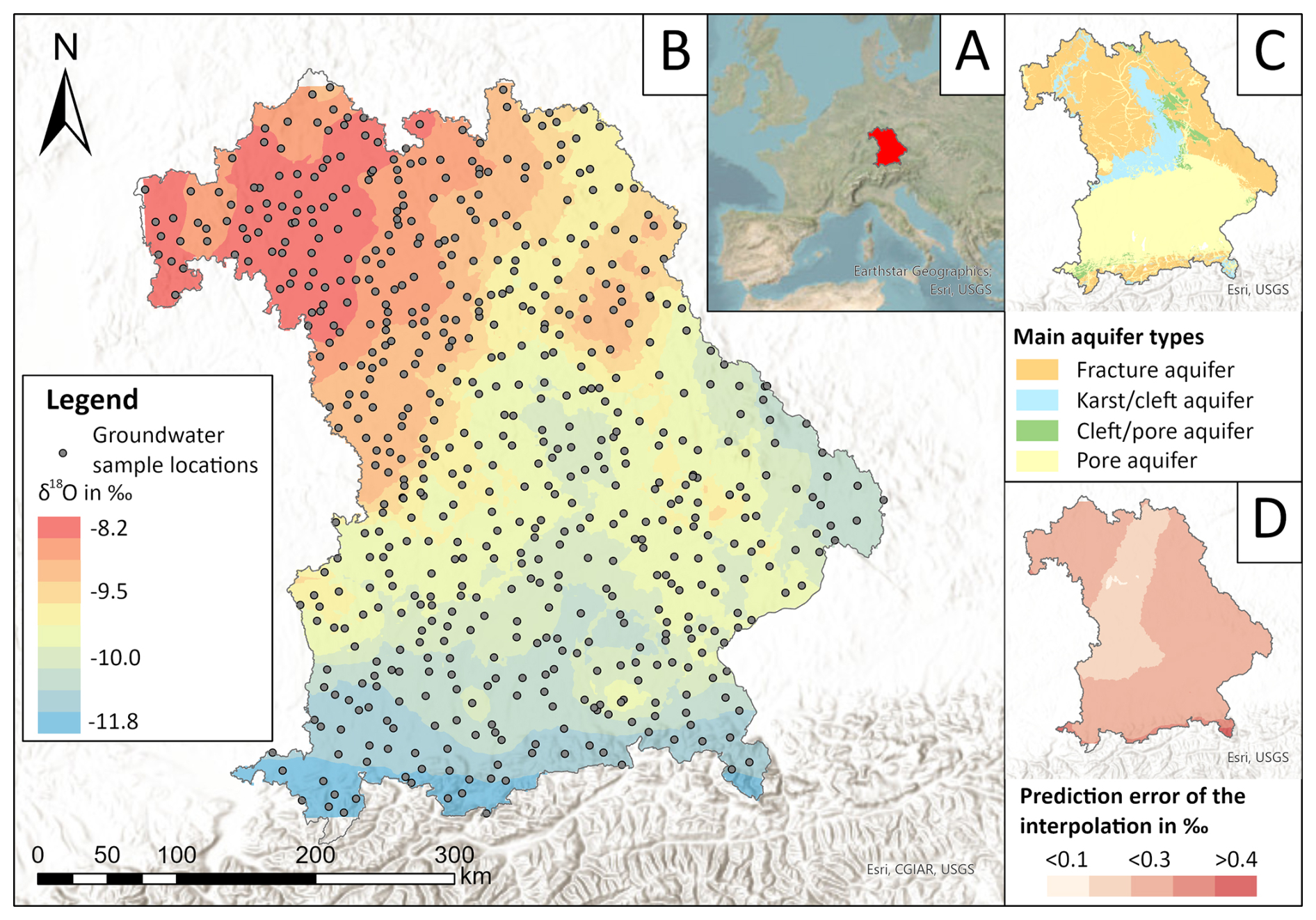
Figure 1(a) Location of the study area in Europe. (b) Groundwater δ18O isoscape (obtained with empirical Bayesian kriging) with sample locations. (c) Main hydrogeological units in Bavaria according to the hydrogeological map for Germany (HÜK250), provided by the German Federal Institute for Geosciences and Natural Resources (Bundesanstalt für Geowissenschaften und Rohstoffe and Staatlichen Geologischen Dienste, 2019). (d) Standard error of the interpolation prediction in ‰.
The distribution of δ18O values in precipitation, as obtained by the interpolation by Terzer et al. (2021), is shown in Fig. S2 in the Supplement. The data range from −13.4 ‰ to −8.8 ‰. The distribution pattern in precipitation depends on the altitude, with the lowest values in the Alps and the eastern regions bordering the study area.
3.2 Groundwater–precipitation comparison
Figure 2 displays the difference of δ18O values between groundwater and precipitation. About 67 % of our investigation area, mainly central Bavaria, showed less than ±0.5 ‰ difference between groundwater and precipitation. When this was the case, we concluded that precipitation recharges groundwater equally throughout the year, with little or no alteration in the isotope signal. We did not further consider these regions in the subsequent discussion that focuses on isotope differences (Δδ values). Areas with substantial differences between isotopes in precipitation and groundwater include the Alps, alpine foreland and molasse basin (19.3 % of the study area), with groundwaters having more negative values than the local precipitation and a maximum difference of 2.1 ‰. In contrast, the north-western part of Bavaria, which roughly corresponds to the Main River region (13.3 % of the study area), showed more negative values in precipitation than in groundwater, with a maximum difference of 1.9 ‰.
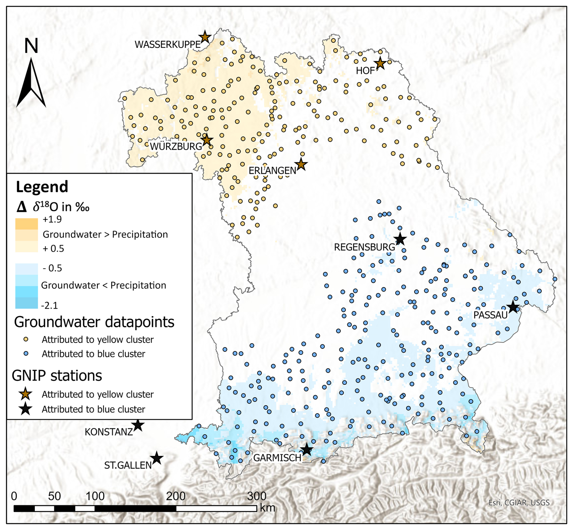
Figure 2Differences between δ18O values of groundwater and precipitation isoscapes (Δδ). Areas with differences smaller than |0.5 ‰| are transparent. The yellow and blue areas mark the clusters with groundwater–precipitation differences ‰|. The groundwater sampling points and GNIP stations attributed to one cluster (according to Sect. 2.5) are also shown.
3.3 Regional water lines and d values
Figure 3 shows the regional water lines (RWLs) for (a) the groundwater and precipitation data in the southern (blue) cluster and (b) groundwater and precipitation data in the northern (yellow) cluster.
In the southern region (Fig. 3a), the groundwater samples (n=262, with mean values of −10.1 ‰ δ18O and −73.0 ‰ δ2H) plot along a trend line with the following equation:
The southern meteoric water line of the monthly precipitation values between 2010 and 2018 in the corresponding GNIP stations (n=420) are
In the northern region of Bavaria (Fig. 3b), the groundwater samples (n=202, with mean values of −9 ‰ δ18O and −63.9 ‰ δ2H) plot along a trend line with the following equation:
The monthly precipitation values between 2010 and 2018 in the corresponding GNIP stations (n=432) are
The reduced spread of groundwater isotope values in comparison to the corresponding precipitation values is most likely the result of subsurface mixing processes along the flow paths and with different water sources from different recharge areas and seasons.
When comparing the groundwater samples in the southern and northern clusters, we observe a clear trend towards less negative values going from south to north with minimum, maximum and mean δ18O values of −12.9 ‰, −6.8 ‰ and −10.1 ‰ and −10.6 ‰, −7.7 ‰ and −9.0 ‰, respectively. This observation reflects the same south–north trend as in the groundwater isoscape (Fig. 1).
The d values in groundwater, displayed in Fig. 4, range from 6.0 to 10.3 ‰, with higher values preferentially found at higher altitudes, although not consistently.
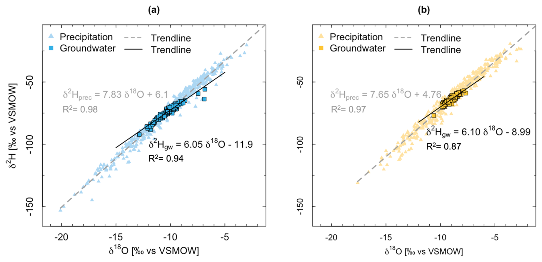
Figure 3Regional meteoric water lines (triangles) and groundwater lines (squares) (a) in the southern alpine and (b) the northern Main River regions.
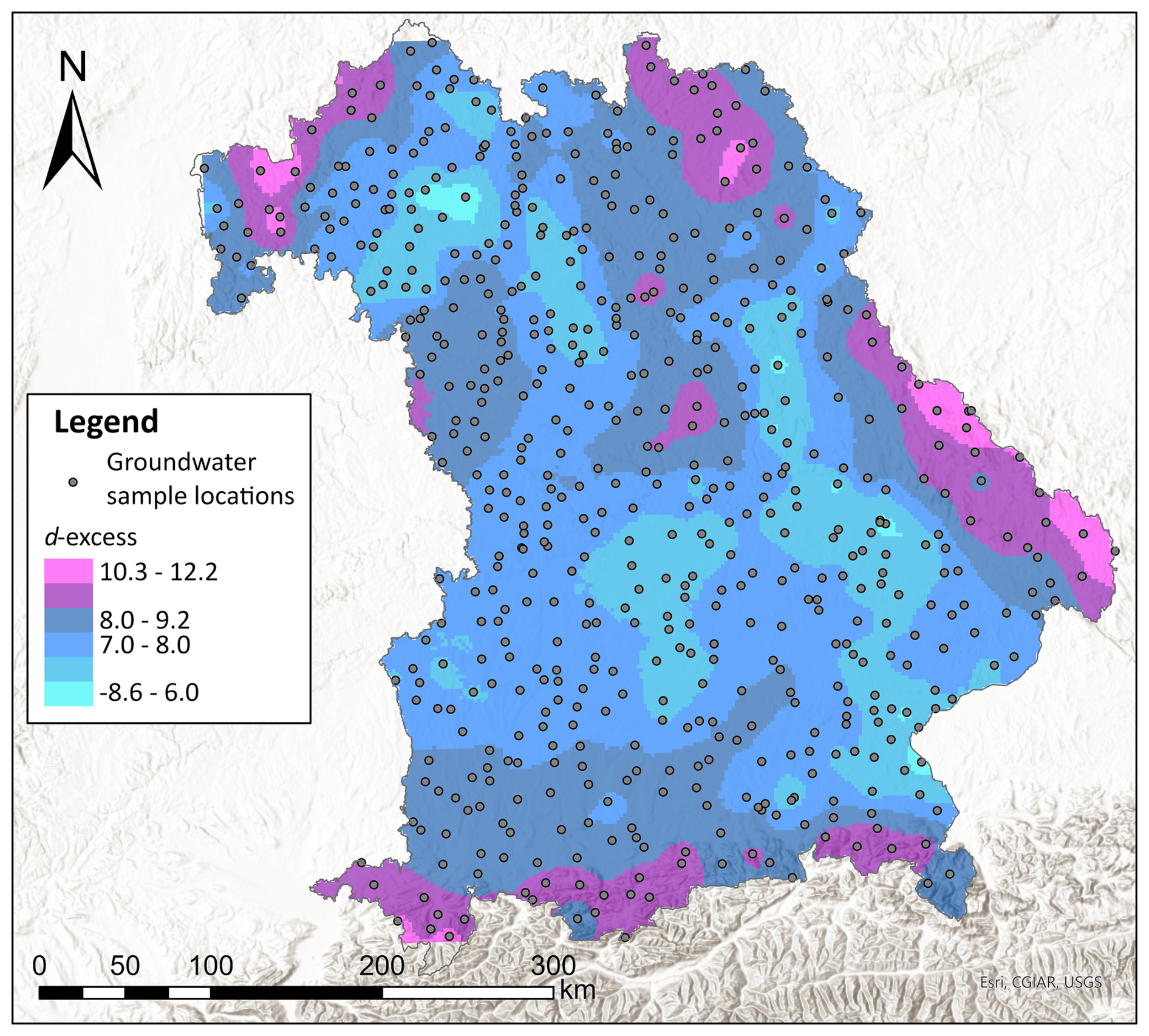
Figure 4Interpolated d values in Bavarian groundwaters (obtained with empirical Bayesian kriging) with sample locations.
4.1 Isoscape comparison
With an average of 0.0084 wells km−2, the presented groundwater dataset shows an exceptionally high density of points. For comparison, the isoscape produced by Regan et al. (2017) for Ireland is based upon 0.0025 wells km−2 (less dense by a factor of 4), and the data density of large-scale groundwater isoscapes for Mexico and Ethiopia lies 1 order of magnitude below (Wassenaar et al., 2009; Bedaso and Wu, 2021). Another advantage of our groundwater dataset is the even distribution of the sampling points across the study area, which covers all major aquifer types in Bavaria, climatic regions and altitudes up to 953 m a.s.l. It must be noted that all groundwater sampling locations lie strictly within the boundaries of Bavaria, and the interpolation shows higher prediction errors at the edges of the study area due to a lack of information outside of Bavaria. This effect is especially visible at the southern fringe of the study area, caused by larger differences among geographically close locations due to the larger heterogeneity of the alpine topography. The disadvantage of strict boundary cutoff is not present with the precipitation isoscape because it is retrieved from a Europe-wide interpolation.
The groundwater was sampled only once, within a short time frame (July 2015). The different groundwater values are therefore comparable. The isotope ratios in groundwater are expected to be representative of the annual average of isotopes in precipitation because neighbouring wells showed similar values across all regions. Additionally, the attenuation of seasonality is expected to take place in the unsaturated zone due to sufficiently long travel times; the isotopic signal is even further dampened when infiltrating water is mixed with a much larger reservoir of existing groundwater with a wide range of ages. However, we cannot confirm that all sampled stations are representative of the annual averages of isotopes in precipitation. Therefore, we recommend investigating the seasonality of the isotope signal in shallow groundwater aquifers with quarterly sampling campaigns.
Nevertheless, the observed trends remain robust because of the high number of consistent results across all regions and the generally low prediction error of the interpolation (<0.3 ‰ δ18O). Thus, we can compare the produced groundwater isoscape to the precipitation map proposed by Terzer et al. (2021). However, if there was a long-time trend in the isotope ratios in the precipitation, repeated groundwater measurements would be needed to assess such a trend.
4.2 Alpine region
The pattern observed in the southern region of Bavaria displays consistently more depleted δ18O values in groundwater than in precipitation. This difference can be caused by predominant groundwater recharge during the colder season. Higher groundwater recharge rates in winter are expected for temperate climates, regions where snowmelt is the dominating recharge process and because of little impact of evapotranspiration on the soil water balance in winter (Jasechko et al., 2014; Clark, 1997; Jasechko et al., 2017). Several studies in Europe have discussed a bias in groundwater isotopes towards winter recharge on local and regional levels (Raidla et al., 2016; Regan et al., 2017; Darling et al., 2003). Additionally, altitude effects are easily recognisable in alpine regions. When groundwater recharge areas lie at higher altitudes than the valley aquifers, groundwater is recharged with δ18O-depleted water. On a global average, altitude effects have been reported to affect the δ18O value in precipitation by −0.2 ‰ per 100 m elevation increase worldwide (Clark, 1997; Hemmerle et al., 2021), but even higher rates of −0.47 ‰ per 100 m have been reported in Germany (Stumpp et al., 2014). In our study area, we calculated an altitude effect of −0.31 ‰ per 100 m in groundwater (Fig. S3 in the Supplement). Moreover, a large part of the precipitation at higher altitudes falls as snow, which further reduces its δ18O values (Clark, 1997).
In the alpine regions, it is therefore plausible that a combination of cold-season groundwater recharge, snowmelt and glacier melt dominated recharge, altitude and temperature effects, which explains the differences of up to 2.1 ‰ between the δ18O values in precipitation and groundwater. The differences we report can be compared to other studies in mountainous areas. For example, Cervi et al. (2017) found no differences between the means and medians in groundwater and precipitation in the Italian Alps. On the other hand, a high-altitude Swiss catchment showed more than 4 ‰ more negative groundwaters than local precipitation (Arnoux et al., 2020).
4.3 Main River region
In the north-west part of Bavaria, the Main River region, the groundwater displayed more positive δ18O values when compared to precipitation. One possible explanation for this situation could be evaporation occurring after precipitation reached the ground. Such evaporation effects can strongly influence the groundwater isotopic composition. For instance, in British Columbia, Wassenaar et al. (2011) reported up to 4.5 ‰ δ18O more positive groundwaters than precipitation. Higher evaporation rates are expected to occur in the Main River region compared to the Alps due to the drier and warmer climate in these plains. The contribution of winter precipitation to groundwater is also less important in the Main River region than in the rest of the study area, both in terms of proportion and isotope signature. The yearly distribution of precipitation, the absence of significant snow cover, and the less-distinctive summer and winter isotope signals (together with shorter winters) all lead to a reduced winter bias in the groundwater isotopes.
Moreover, a factor that supports higher evaporation in the Main River region is the presence of widespread cropland in need of irrigation (43 % of the area in the Main River region opposed to 35 % in the alpine region according to the land use; European Space Agency, 2023). This implies that potentially large amounts of groundwater are spread on the surface and become subject to evaporation. Cherry et al. (2020) correlated the density of irrigation wells with the groundwater isotopic signal in Nebraska. They concluded that groundwaters in intensively irrigated areas showed an isotopic signature shift towards the non-growing season, whereas the rest of the state was not affected by this trend. In this study area, the origin and quantity of the water used for irrigation could not be quantified, yet we can usually consider irrigation to be conducted with groundwater, therefore amplifying the evaporation effects seen in groundwater.
Another factor that could argue for higher evaporation is the presence of the surface water body of the Main River, which in turn partly feeds the groundwater. However, a 2013 study of the Main River shows that the δ18O values vary between −10.0 ‰ in winter and −9.0 ‰ in summer, which does not explain the groundwater δ18O values as far as 40 km from the river course (Türk, 2013). Moreover, no extensive artificial recharge is performed in the Main River region that would further increase the evaporation effect.
Despite these considerations (climate, irrigation and groundwater fed by surface water), the evaporation effect is barely seen in the RWL and d values: the regional groundwater line indeed displays a smaller slope than the precipitation line and indicates that evaporation might take place after precipitation reaches the ground. This slope difference is slightly greater in the Main River region than in the Bavarian Alps and further supports the hypothesis of a more pronounced evaporation effect in the Main River region. However, in the case of our study, the statistical differences between groundwater and precipitation do not currently allow us to conclude on a significant evaporation effect. The d values isoscape shows higher d values with higher elevations. Nonetheless, no spatial correlations to the southern alpine or northern Main River region could be observed. The distribution of d values does not allow us to draw conclusions on different evaporative conditions between the Main River region and the rest of the study area. This suggests that evaporation alone is not likely to be the main explanation for the 2 ‰ more positive δ18O signal in the groundwater compared to precipitation in the Main River region. A bias of the groundwater isotope signal towards the warm-season precipitation due to summer groundwater recharge is not expected in our study area because the main groundwater recharge season in temperate Central Europe remains winter.
Contributions from other (presumably deeper) aquifers may be a possibility if they add isotopically more positive waters. However, studies around Nuremberg by van Geldern et al. (2014) found more negative isotope values in deeper aquifers. A connection between the upper aquifer and deeper groundwater is unlikely in the Main River region, as no deep aquifer is found in north-west Bavaria (Büttner et al., 2003). Moreover, contributions via hydraulic windows would rather cause highly localised effects and hardly explain the spatial extent of the effects found here. Similarly, we would not expect the influence of leeching tap water to influence the groundwater on the regional scale. Preferential flow paths are another plausible mechanism to explain the observed pattern (Chen et al., 2023, 2024). They would apply to the scale observed in this study if heavy rain events with a more positive isotope signal (e.g. summer precipitation) influenced the aquifer. This is theoretically possible in the typical aquifers found in this region.
One further explanation for the isotopically heavier groundwater in the Main River region can be attributed to the sampling time during the month of July 2015. Overall, stable isotopes in groundwater are assumed to show only limited seasonal variations. Nonetheless, a lysimeter study by Stumpp et al. (2012), performed with Bavarian soils and climate, reported that water isotopes show seasonality throughout the unsaturated zone, at least up until a depth of 2 m below the ground surface. On larger scales, Regan et al. (2017) also observed seasonal variation in groundwater at local scales in regions with rapid groundwater recharge. In the Main River region, it is possible that the isotope signal in precipitation produces seasonal patterns in the groundwater because our sampling focused on shallow aquifers, and the region is characterised by karst and fracture aquifers that provide favourable conditions for rapid transit times and low dispersivities. This might be an important and a so-far hardly acknowledged reason for the up to 2 ‰ more positive groundwater δ18O values when compared to precipitation. To investigate this aspect of groundwater isotopes, longer time series and at least quarterly sampling campaigns of groundwater, surface water and precipitation would be necessary. So far, our data indicate a scarce but potentially critical seasonality of large-scale groundwater recharge processes.
In this study, we produced a high-resolution regional groundwater isoscape of δ18O values in southern Germany. For the first time, and as requested by previous studies, the data points were densely and evenly distributed across the study area and aquifer types, and all samples were analysed according to the same strict protocols to reduce methodical uncertainties. The observed spatial pattern shows δ18O-depleted values in the southern alpine region and δ18O-enriched values in the Main River region in the north-west of Bavaria. Further, comparisons between groundwater and precipitation isoscapes showed local and regional differences between these connected hydrologic compartments.
Differences in the southern alpine region can be explained by the winter groundwater recharge, altitude effects and important snow cover. On the other hand, the more positive groundwaters in the northern Main River are more difficult to explain, and hypotheses for this situation include evaporation after precipitation reached the ground, reduced winter groundwater recharge, possible connection to a deep-water aquifer and, perhaps most importantly, a bias due to the sampling season of the groundwater samples. This last hypothesis especially would benefit from quarterly groundwater sampling campaigns in order to investigate the seasonality of stable isotopes in the upper aquifer on a regional scale. In addition, better documentation of the local irrigation practices and surface waters via stable isotopes would provide insights into the regional water balance.
This study shows that the consideration of stable isotope values of both precipitation and groundwater are promising in outlining and understanding regional recharge mechanisms. Our results highlight the need for a better understanding of the seasonality of large-scale groundwater recharge patterns, based on quarterly or monthly sampling campaigns of all parts of the hydrologic cycle. Such investigations are gaining more importance with climate change. In Bavaria, the expected changes in the water cycle, also due to climate change, tend towards increased precipitation. However, with intense rain events in summer, their uneven distribution throughout the year is expected to not contribute much to the groundwater recharge, a trend that has been observed for several years already (Bayerisches Landesamt für Umwelt, 2022). Groundwater scarcity, especially in summer when needs are highest, leads to increasing conflicts about its use. In this context, knowledge of the isotope composition of groundwater helps to set this waterbody in relation to precipitation and surface waters. Our study proposes for the first time a distribution of background values for isotopes in groundwater, which will also help to frame local investigations about recharge quantification or groundwater isotopic tracing or use scenarios to support policymaking, resource management and environmental conservation efforts. Furthermore, this study may be replicated or widened to cover other and/or larger regions.
Original isotope data are available upon request.
The supplement related to this article is available online at https://doi.org/10.5194/hess-29-3853-2025-supplement.
AG prepared the paper, with contributions from all co-authors. RvG and JACB supervised the groundwater sampling and laboratory analyses. CS curated and provided the precipitation data. AG applied the model and statistics.
The contact author has declared that none of the authors has any competing interests.
Publisher's note: Copernicus Publications remains neutral with regard to jurisdictional claims made in the text, published maps, institutional affiliations, or any other geographical representation in this paper. While Copernicus Publications makes every effort to include appropriate place names, the final responsibility lies with the authors.
We thank the Bayerisches Landesamt für Umwelt and 17 Bavarian water management authorities for their participation as well as Tobias Juhlke for the logistics and organisation of the sampling.
This research has been supported by the Bundesministerium für Bildung und Forschung (grant no. 02WGW1671A).
This paper was edited by Zhongbo Yu and reviewed by Xuegao Chen and two anonymous referees.
ArcGIS Pro Documentation: https://pro.arcgis.com/en/pro-app/2.9/tool-reference/geostatistical-analyst/empirical-bayesian-kriging.htm, last access: 1 December 2023.
Arnoux, M., Halloran, L. J. S., Berdat, E., and Hunkeler, D.: Characterizing seasonal groundwater storage in alpine catchments using time-lapse gravimetry, water stable isotopes and water balance methods, Hydrol. Process., 34, 4319–4333, https://doi.org/10.1002/hyp.13884, 2020.
Bayerisches Landesamt für Umwelt: Mittlere Jährliche Grundwasserneubildung in Bayern 1981–2010, Bayerisches Landesamt für Umwelt (LfU), Augsburg, 2018.
Bayerisches Landesamt für Umwelt: Mittlere Grundwasserneubildung in den Bezirken der bayerischen Wasserwirtschaftsämter, Bayerisches Landesamt für Umwelt, Augsburg, 1–2, 2020.
Bayerisches Landesamt für Umwelt: Sicherheit der Wasserversorgung in Not-, Krisen- und Katastrophenfälle, Bayerisches Landesamt für Umwelt, Augsburg, 2022.
Bayerisches Staatsministerium für Umwelt und Verbraucherschutz: Klima-Report Bayern 2021, Klimawandel, Auswirkungen, Anpassungs- und Forschungsaktivitäten, 2021.
Beck, H. E., Zimmermann, N. E., McVicar, T. R., Vergopolan, N., Berg, A., and Wood, E. F.: Publisher Correction: Present and future Köppen-Geiger climate classification maps at 1-km resolution, Sci. Data, 7, 274, https://doi.org/10.1038/s41597-020-00616-w, 2020.
Bedaso, Z. and Wu, S.-Y.: Linking precipitation and groundwater isotopes in Ethiopia – Implications from local meteoric water lines and isoscapes, J. Hydrol., 596, 126074, https://doi.org/10.1016/j.jhydrol.2021.126074, 2021.
Bowen, G. J.: Isoscapes: Spatial Pattern in Isotopic Biogeochemistry, Annu. Rev. Earth Planet. Sci., 38, 161–187, https://doi.org/10.1146/annurev-earth-040809-152429, 2010.
Bowen, G. J. and Revenaugh, J.: Interpolating the isotopic composition of modern meteoric precipitation, Water Resour. Res., 39, 1299, https://doi.org/10.1029/2003wr002086, 2003.
Bowen, G. J. and Wilkinson, B. H.: Spatial distribution of δ18O in meteoric precipitation, Geol. Soc. Am., 30, 315–318, https://doi.org/10.1130/0091-7613(2002)030<0315:SDOOIM>2.0.CO;2, 2002.
Bowen, G. J., Chesson, L., Nielson, K., Cerling, T. E., and Ehleringer, J. R.: Treatment methods for the determination of δ2H and δ18O of hair keratin by continuous-flow isotope-ratio mass spectrometry, Rapid Commun. Mass Spectrom., 19, 2371–2378, https://doi.org/10.1002/rcm.2069, 2005.
Bowen, G. J., Cai, Z., Fiorella, R. P., and Putman, A. L.: Isotopes in the Water Cycle: Regional- to Global-Scale Patterns and Applications, Annu. Rev. Earth Planet. Sci., 47, 453–479, https://doi.org/10.1146/annurev-earth-053018-060220, 2019.
Brkić, Ž., Kuhta, M., Hunjak, T., and Larva, O.: Regional Isotopic Signatures of Groundwater in Croatia, Water, 12, 1983, https://doi.org/10.3390/w12071983, 2020.
Bundesanstalt für Geowissenschaften und Rohstoffe, B. and Staatlichen Geologischen Dienste, S.: Hydrogeologische Übersichtskarte 1:250 000 von Deutschland (HÜK250), 2019.
Bundesministerium für Umwelt Naturschutz und Reaktorsicherheit: HAD, Hydrologischer Atlas von Deutschland, Naturschutz und Reaktorsicherheit, Freiburger Verlagsdienste, 2003.
Büttner, G., Pamer, R., and Wagner, B.: Hydrogeologische Raumgliederung von Bayern, Bayerisches Geologisches Landesamt, ISSN 0932-9269, 2003.
Cerling, T. E., Barnette, J. E., Bowen, G. J., Chesson, L. A., Ehleringer, J. R., Remien, C. H., Shea, P., Tipple, B. J., and West, J. B.: Forensic Stable Isotope Biogeochemistry, Annu. Rev. Earth Planet. Sci., 44, 175–206, https://doi.org/10.1146/annurev-earth-060115-012303, 2016.
Cervi, F., Borgatti, L., Dreossi, G., Marcato, G., Michelini, M., and Stenni, B.: Isotopic features of precipitation and groundwater from the Eastern Alps of Italy: results from the Mt. Tinisa hydrogeological system, Environ. Earth Sci., 76, 410, https://doi.org/10.1007/s12665-017-6748-9, 2017.
Chen, X., Yu, Z., Yi, P., Aldahan, A., Hwang, H.-T., and Sudicky, E. A.: Disentangling runoff generation mechanisms: Combining isotope tracing with integrated surface/subsurface simulation, J. Hydrol., 617, 129149, https://doi.org/10.1016/j.jhydrol.2023.129149, 2023.
Chen, X., Yu, Z., Yi, P., Hwang, H.-T., Sudicky, E. A., Tang, T., and Aldahan, A.: Effects of soil heterogeneity and preferential flow on the water flow and isotope transport in an experimental hillslope, Sci. Total Environ., 917, 170548, https://doi.org/10.1016/j.scitotenv.2024.170548, 2024.
Cherry, M., Gilmore, T., Mittelstet, A., Gastmans, D., Santos, V., and Gates, J. B.: Recharge seasonality based on stable isotopes: Nongrowing season bias altered by irrigation in Nebraska, Hydrol. Process., 34, 1575–1586, https://doi.org/10.1002/hyp.13683, 2020.
Clark, I. D. F. P.: Environmental Isotopes in Hydrogeology, CRC Press, https://doi.org/10.1201/9781482242911, 1997.
Coplen, T. B.: Guidelines and recommended terms for expression of stable-isotope-ratio and gas-ratio measurement results, Rapid Commun. Mass Spectrom., 25, 2538–2560, https://doi.org/10.1002/rcm.5129, 2011.
Craig, H.: Isotopic Variations in Meteoric Waters, Science, 133, 1702–1703, https://doi.org/10.1126/science.133.3465.1702, 1961.
Craig, H. and Gordon, L. I.: Deuterium and oxygen 18 variations in the ocean and marine atmosphere, Proc. Stable Isotopes in Oceanographic Studies and Paleotemperatures, Spoleto, Italy, 9–130, 1965.
Dansgaard, W.: Stable isotopes in precipitation, Tellus, 16, 436–468, https://doi.org/10.3402/tellusa.v16i4.8993, 1964.
Darling, W. G.: The isotope hydrology of quaternary climate change, J. Human Evol., 60, 417–427, https://doi.org/10.1016/j.jhevol.2010.05.006, 2011.
Darling, W. G., Bath, A. H., and Talbot, J. C.: The O and H stable isotope composition of freshwaters in the British Isles. 2. Surface waters and groundwater, Hydrol. Earth Syst. Sci., 7, 183–195, https://doi.org/10.5194/hess-7-183-2003, 2003.
Delavau, C., Chun, K. P., Stadnyk, T., Birks, S. J., and Welker, J. M.: North American precipitation isotope (δ18O) zones revealed in time series modeling across Canada and northern United States, Water Resour. Res., 51, 1284–1299, https://doi.org/10.1002/2014WR015687, 2015.
Edmunds, W. M.: Palaeowaters in European coastal aquifers – the goals and main conclusions of the PALAEAUX project, in: Palaeowaters in Coastal Europe: Evolution of Groundwater Since the Late Pleistocene, edited by: Edmunds, W. M., 1, Geological Society of London Special Publications, London, 1–16, https://doi.org/10.1144/gsl.sp.2001.189.01.02, 2001.
European Space Agency: WorldCover: https://www.arcgis.com/home/item.html?id=e28b7e1da5414010ba4f47dd5a3c3ebb, last access: 1 December 2023.
Hemmerle, H., van Geldern, R., Juhlke, T. R., Huneau, F., Garel, E., Santoni, S., and Barth, J. A. C.: Altitude isotope effects in Mediterranean high-relief terrains: a correction method to utilize stream water data, Hydrolog. Sci. J., 66, 1409–1418, https://doi.org/10.1080/02626667.2021.1928672, 2021.
Hobson, K. A., Wassenaar, L. I., and Taylor, O. R.: Stable isotopes (δD and δ13C) are geographic indicators of natal origins of monarch butterflies in eastern North America, Oecologia, 120, 397–404, https://doi.org/10.1007/s004420050872, 1999.
Hollins, S. E., Hughes, C. E., Crawford, J., Cendon, D. I., and Meredith, K. T.: Rainfall isotope variations over the Australian continent – Implications for hydrology and isoscape applications, Sci. Total. Environ., 645, 630–645, https://doi.org/10.1016/j.scitotenv.2018.07.082, 2018.
IAEA: Isotope Hydrology Network: https://isotopehydrologynetwork.iaea.org, last access: 1 September 2023a.
IAEA: WISER-Database: https://nucleus.iaea.org/wiser, last access: 1 December 2023b.
Jasechko, S., Birks, S. J., Gleeson, T., Wada, Y., Fawcett, P. J., Sharp, Z. D., McDonnell, J. J., and Welker, J. M.: The pronounced seasonality of global groundwater recharge, Water Resour. Res., 50, 8845–8867, https://doi.org/10.1002/2014WR015809, 2014.
Jasechko, S., Wassenaar, L. I., and Mayer, B.: Isotopic evidence for widespread cold-season-biased groundwater recharge and young streamflow across central Canada, Hydrol. Process., 31, 2196–2209, https://doi.org/10.1002/hyp.11175, 2017.
Jiráková, H., Huneau, F., Celle-Jeanton, H., Hrkal, Z., and Le Coustumer, P.: Insights into palaeorecharge conditions for European deep aquifers, Hydrogeol. J., 19, 1545–1562, https://doi.org/10.1007/s10040-011-0765-7, 2011.
Ju, Q., Hu, Y., Liu, Q., Chen, K., Zhang, H., and Wu, Y.: Multiple stable isotopes and geochemical approaches to elucidate groundwater reactive transport paths in mining cities: A case from the northern Anhui, China, Sci. Total. Env., 912, 169706, https://doi.org/10.1016/j.scitotenv.2023.169706, 2024.
Koeniger, P., Gaj, M., Beyer, M., and Himmelsbach, T.: Review on soil water isotope-based groundwater recharge estimations, Hydrol. Process., 30, 2817–2834, https://doi.org/10.1002/hyp.10775, 2016.
Leśniak, P. M. and Wilamowski, A.: The δ18O and δD isoscapes of recent groundwater in Poland, Geologos, 25, 205–211, https://doi.org/10.2478/logos-2019-0022, 2019.
Lorenzi, V., Banzato, F., Barberio, M. D., Goeppert, N., Goldscheider, N., Gori, F., Lacchini, A., Manetta, M., Medici, G., Rusi, S., and Petitta, M.: Tracking flowpaths in a complex karst system through tracer test and hydrogeochemical monitoring: Implications for groundwater protection (Gran Sasso, Italy), Heliyon, 10, e24663, https://doi.org/10.1016/j.heliyon.2024.e24663, 2024.
Lykoudis, S. P. and Argiriou, A. A.: Gridded data set of the stable isotopic composition of precipitation over the eastern and central Mediterranean, J. Geophys. Res.-Atmos., 112, D18107, https://doi.org/10.1029/2007JD008472, 2007.
Négrel, P. and Petelet-Giraud, E.: Isotopes in groundwater as indicators of climate changes, TrAC Trend. Anal. Chem., 30, 1279–1290, https://doi.org/10.1016/j.trac.2011.06.001, 2011.
Raidla, V., Kern, Z., Pärn, J., Babre, A., Erg, K., Ivask, J., Kalvāns, A., Kohán, B., Lelgus, M., Martma, T., Mokrik, R., Popovs, K., and Vaikmäe, R.: A δ18O isoscape for the shallow groundwater in the Baltic Artesian Basin, J. Hydrol., 542, 254–267, https://doi.org/10.1016/j.jhydrol.2016.09.004, 2016.
Regan, S., Goodhue, R., Naughton, O., and Hynds, P.: Geospatial drivers of the groundwater δ18O isoscape in a temperate maritime climate (Republic of Ireland), J. Hydrol., 554, 173–186, https://doi.org/10.1016/j.jhydrol.2017.09.017, 2017.
Riedel, T. and Weber, T. K. D.: Review: The influence of global change on Europe's water cycle and groundwater recharge, Hydrogeol. J., 28, 1939–1959, https://doi.org/10.1007/s10040-020-02165-3, 2020.
Rozanski, K., Araguás-Araguás, L., and Gonfiantini, R.: Isotopic patterns in modern global precipitation, in: Climate changes in continental isotopic records, edited by: Swart, P. K., Lohmann, K. C., McKenzie, J., and Savin, S., Geophysical Monograph Series, 78, American Geophysical Union, Washington, D.C., 1–36, 1993.
Stumpp, C., Klaus, J., and Stichler, W.: Analysis of long-term stable isotopic composition in German precipitation, J. Hydrol., 517, 351–361, https://doi.org/10.1016/j.jhydrol.2014.05.034, 2014.
Stumpp, C., Stichler, W., Kandolf, M., and Šimůnek, J.: Effects of Land Cover and Fertilization Method on Water Flow and Solute Transport in Five Lysimeters: A Long-Term Study Using Stable Water Isotopes, Vadose Zone J., 11, https://doi.org/10.2136/vzj2011.0075, 2012.
Terzer, S., Wassenaar, L. I., Araguás-Araguás, L. J., and Aggarwal, P. K.: Global isoscapes for δ18O and δ2H in precipitation: improved prediction using regionalized climatic regression models, Hydrol. Earth Syst. Sci., 17, 4713–4728, https://doi.org/10.5194/hess-17-4713-2013, 2013.
Terzer, S., Wassenaar, L. I., Welker, J. M., and Araguás-Araguás, L. J.: Improved high-resolution global and regionalized isoscapes of δ18O, δ2H and d-excess in precipitation, Hydrol. Process., 35, e14254, https://doi.org/10.1002/hyp.14254, 2021.
Türk, T.: Anthropogene und geogene Einflüsse auf den Main-Hauptfluss, Master thesis, Faculty of Natural Sciences, Friedrich-Alexander-Universität Erlangen-Nürnberg, 2013.
van Geldern, R. and Barth, J. A. C.: Optimization of instrument setup and post-run corrections for oxygen and hydrogen stable isotope measurements of water by isotope ratio infrared spectroscopy (IRIS), Limnol. Oceanogr.-Methods, 10, 1024–1036, https://doi.org/10.4319/lom.2012.10.1024, 2012.
van Geldern, R., Baier, A., Subert, H. L., Kowol, S., Balk, L., and Barth, J. A. C.: Pleistocene paleo-groundwater as a pristine fresh water resource in southern Germany – evidence from stable and radiogenic isotopes, Sci. Total. Environ., 496, 107–115, https://doi.org/10.1016/j.scitotenv.2014.07.011, 2014.
Wassenaar, L. I. and Hobson, K. A.: Natal origins of migratory monarch butterflies at wintering colonies in Mexico: New isotopic evidence, P. Natl. Acad. Sci. USA, 95, 15436–15439, https://doi.org/10.1073/pnas.95.26.15436, 1998.
Wassenaar, L. I., Van Wilgenburg, S. L., Larson, K., and Hobson, K. A.: A groundwater isoscape (δD, δ18O) for Mexico, J. Geochem. Explor., 102, 123–136, https://doi.org/10.1016/j.gexplo.2009.01.001, 2009.
Wassenaar, L. I., Athanasopoulos, P., and Hendry, M. J.: Isotope hydrology of precipitation, surface and ground waters in the Okanagan Valley, British Columbia, Canada, J. Hydrol., 411, 37–48, https://doi.org/10.1016/j.jhydrol.2011.09.032, 2011.
West, J. B., Bowen, G. J., Dawson, T. E., and Tu, K. P.: Isoscapes Understanding movement, pattern, and process on Earth through isotope mapping, Springer Science+Business Media, https://doi.org/10.1007/978-90-481-3354-3, 2008a.
West, J. B., Sobek, A., and Ehleringer, J. R.: A Simplified GIS Approach to Modeling Global Leaf Water Isoscapes, Plos One, 3, e2447, https://doi.org/10.1371/journal.pone.0002447, 2008b.
Wheater, H. S., Mathias, S., Li, X., Edmunds, W. M., Carrera, J., Ahmed, S., Nabi, A., Owais, S., A. Butler, A., Simmons, C. T., Bauer-Gottwein, P., Graf, T., Kinzelbach, W., Kooi, H., Li, L., Post, V., Prommer, H., Therrien, R., Voss, C., Ward, J., Werner, A., Kinzelbach, W., Brunner, P., von Boetticher, A., Kgotlhang, L., and Milzow, C.: Groundwater Modelling in Arid and Semi-Arid Areas, Cambridge University Press, New York, 2010.
Yousif, M., van Geldern, R., and Bubenzer, O.: Hydrogeological investigation of shallow aquifers in an arid data-scarce coastal region (El Daba'a, northwestern Egypt), Hydrogeol. J., 24, 159–179, https://doi.org/10.1007/s10040-015-1308-4, 2016.