the Creative Commons Attribution 4.0 License.
the Creative Commons Attribution 4.0 License.
 | 15 Jul 2025
The impact of geological structures on groundwater potential assessment in volcanic rocks in the Borena Sayint district, northwestern Ethiopian Plateau: a review
Ajebush Wuletaw
This review explores the influence of geological structures on groundwater potential in the Borena Sayint district, northwestern Ethiopian Plateau. The region's tectonic complexity has shaped fractures, faults, and folds that critically affect groundwater storage and flow, particularly in volcanic terrains with limited primary porosity. Structural features such as faults, fractures, and lineaments enhance secondary porosity and control aquifer dynamics by guiding recharge, flow, and discharge processes. Case studies demonstrate how these features interact with volcanic lithology and tectonic processes, influencing groundwater movement. The review emphasizes the importance of integrating geological, geophysical, and hydrological methods for effective exploration and sustainable management of groundwater resources in structurally and lithologically complex volcanic regions.
- Article
(1810 KB) - Full-text XML
- BibTeX
- EndNote


The Ethiopian Rift (ER) is part of the East African Rift System (EARS) and comprises a series of rift zones extending from the Afar triple junction at the Red Sea and Gulf of Aden intersection to the Kenya Rift. The Main Ethiopian Rift (MER) constitutes the northernmost part of the EARS, trending NE–SW and connecting the EARS with the Afar triple junction. It is an area characterized by active extensional tectonics and volcanism. The northwestern Ethiopian Plateau, dominated by volcanic rocks formed by Tertiary to Quaternary volcanic activities, is significantly influenced by tectonic processes, particularly those related to the East African Rift System (WoldeGabriel et al., 1990; Chernet et al., 1998; Tafesse and Alemaw, 2020). Groundwater in volcanic areas is controlled by the physical properties of volcanic rocks and the structural changes caused by tectonic activity. Key factors such as lithological heterogeneity, the degree of fracturing, and weathering processes dictate the distribution of groundwater in these regions (Kebede, 2013). The MER started to develop during Miocene times (Davidson and Rex, 1980; WoldeGabriel et al., 1990; Chernet et al., 1998), and it is also characterized by well-developed Quaternary faulting that is mostly related to rift zone geological structures (Mohr, 1967; Bonini et al., 2005; Boccaletti et al., 1999; Acocella et al., 2002; Chorowicz, 2005). Faults and other geologic structures influence the groundwater flow and other subsurface fluids. There is increasing evidence for a close interaction between subsurface fluids and faulting (Hardbeck and Hauksson, 1999). Groundwater is the major source of fresh water that provides for domestic, industrial, and agricultural use in many developing countries, like Ethiopia (Kebede et al., 2005; Ayenew et al., 2008; Azagegn et al., 2015; Tigabu et al., 2020). Water is generated through a large number of shallow and deep bore wells and dug wells. Ethiopia has a significant number of groundwater resources and is designated as the “Water Tower” of Northeast Africa due to the existence of many rivers that drain from the highlands to the lowlands and to neighbouring countries (Kebede et al., 2005; Tigabu et al., 2020).
The occurrence and movement of groundwater in an area are controlled by geological structures, like faults, fractures, joints, lineaments, and dykes, which significantly influence groundwater dynamics (Chowdhury et al., 2009; Jaiswal et al., 2003). In arid and semi-arid areas, and even in temperate climates, groundwater potential assessment and its flow direction are key challenges in determining the sustainable yield of aquifers (Crosbie et al., 2010). These structures can act either as barriers or conduits for groundwater flow, depending on their characteristics such as orientation, density, connectivity, and permeability (Acocella et al., 2002). Faults and fractures often facilitate groundwater flow, while folds and impermeable layers can obstruct it. The interaction between subsurface fluids and faulting is well documented (Hardbeck and Hauksson, 1999), making the study of these structures essential for effective groundwater management, particularly in areas where water resources are scarce. Due to inadequate surface water resources, most of the requirements for irrigation, industry, and domestic purposes are being met through groundwater resources. Therefore, it is essential to ensure the availability of groundwater throughout the year. Among the methods of assessment, the groundwater resource occurrence and flow interpreting of the impacts of geological structures and geomorphological parameters are very important techniques. These can be used for the rapid assessment of groundwater resources with detailed fieldwork and the advances and availability of satellite images, which can be used to indirectly identify the ground conditions through the surface and subsurface features such as topography, land use, drainage, geology, and geomorphology (Srinivasa and Jugran, 2003; Mondal et al., 2008). The flow and occurrence of groundwater are strongly controlled by the geological structures and geomorphological setup of the volcanic rocks and associated sediments. These geologic structures like dykes, lineaments, and fractures act as both carriers and barriers for groundwater flow (Nilsen et al., 2003; Perrin et al., 2011).
The Borena Sayint district (Fig. 1) is situated on the margin of the northern Main Ethiopian Rift, which is intensively affected by rift tectonics. The source of groundwater in the watershed zone is controlled by rift structures. In the study area, the distribution and supply of daily water for urban and rural areas are fulfilled by groundwater, but it is not evenly distributed due to high populations, urbanization, the increasing need for rural drinking water, and irrigation demand. In spite of the large-scale use of groundwater in this area, it has not been classified based on the potential zone of groundwater flow and distribution. This review aims to provide a deeper understanding of how geological structures shape groundwater potential in volcanic regions and their interpretation with respect to the groundwater potential zones, particularly in the Borena Sayint district in the northwestern Ethiopian Plateau.
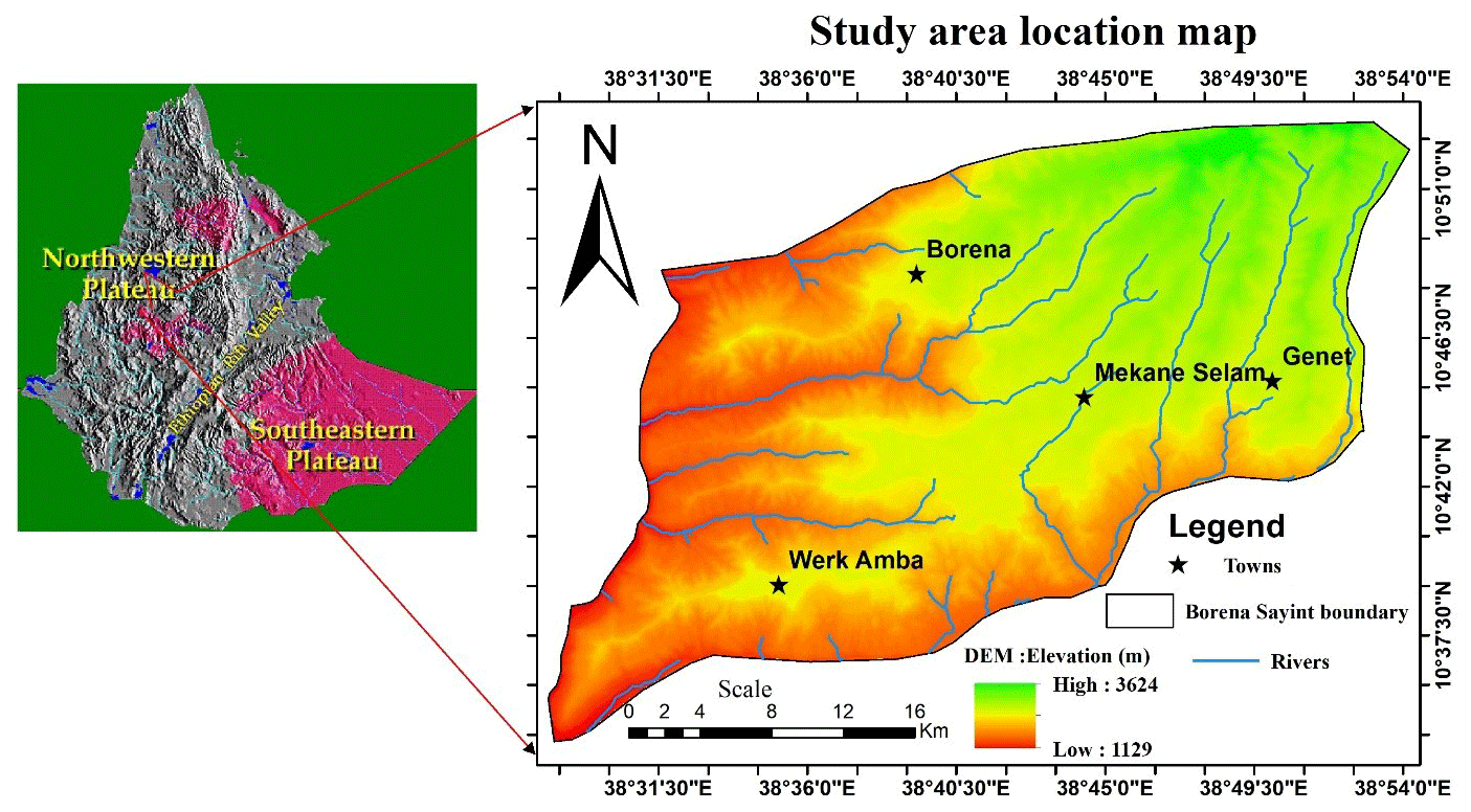
Figure 1The location map of the study area.
Assessing groundwater potential in volcanic terrains requires a multifaceted approach, integrating geological, geophysical, remote sensing, GIS, and hydrogeological methods.
2.1 Geological mapping
Geological mapping is a crucial tool for understanding the distribution of faults, fractures, and folds in volcanic regions. Detailed structural mapping helps to identify key areas for groundwater recharge and defines aquifer boundaries (Mohr and Zanettin, 1988; Berhanu et al., 2014). This method allows for the identification of fault zones, fractures, and variations in rock types critical to groundwater exploration (Kebede, 2013). Field studies are essential for observing surface fractures and correlating them with groundwater potential. Mapping fracture zones helps to assess their orientation, density, and connectivity, which are important for groundwater flow (Seifu et al., 2022; Kebede et al., 2008). Remote sensing techniques, combined with GIS, enhance lineament detection and analysis. High-resolution satellite images, such as those from Landsat and Sentinel-2, and digital elevation models (DEMs) help to identify and analyse lineaments, while GIS tools assist in calculating lineament density, providing valuable information for groundwater mapping (Berhanu et al., 2014).
2.2 Geophysical techniques
Geophysical methods, including electrical resistivity, seismic surveys, and magnetic techniques, are commonly used to explore subsurface structures and aquifers. These methods are effective in detecting fault zones associated with groundwater movement (Seifu et al., 2022) and in mapping fracture zones within aquifers (Berhanu et al., 2014). In particular, electrical resistivity surveys are valuable for high-resolution mapping of shallow fractures, helping to delineate areas with significant groundwater potential (Alehegn, 2024).
2.3 Remote sensing and GIS
Remote sensing and GIS are powerful tools for lineament mapping and spatial analysis of groundwater potential. By combining remote sensing data with field observations, these tools have improved the efficiency of groundwater exploration (Tesfaye et al., 2020). Satellite imagery, such as from Landsat or Sentinel-2, can be used to map lineaments, revealing fracture patterns that directly correlate with groundwater potential. The integration of GIS allows for spatial analysis that enhances the understanding of groundwater systems and aids in predicting areas of high groundwater yield (Tesfaye et al., 2020).
2.4 Hydrogeological studies
Hydrogeological studies, including aquifer tests, tracer studies, and water table monitoring, are essential for understanding aquifer properties and groundwater movement. These studies provide insights into recharge rates, flow mechanisms, and the dynamics of fractured aquifers. Hydraulic tests, such as pumping and slug tests, help to quantify key parameters like hydraulic conductivity and transmissivity in fractured aquifers (Kebede, 2013). The results are vital for assessing the productivity of groundwater systems influenced by geological structures. Areas with dense lineament patterns often correlate with high-yield groundwater wells, particularly where lineament intersections occur, as they enhance permeability and groundwater flow (Kebede, 2013). Combining lineament analysis with other hydrogeological data provides a comprehensive understanding of groundwater potential, especially in arid and semi-arid regions where groundwater is a vital resource (Tesfaye et al., 2020).
3.1 Faults and their role in groundwater systems
Faults play a significant role in shaping groundwater potential by creating pathways for water flow or acting as barriers. Normal faults often facilitate groundwater recharge, while reverse faults can restrict flow due to compression and low permeability (Kebede, 2013). The hydraulic conductivity of fault zones varies depending on the infilling material; materials like clay or gouge reduce permeability, while open fractures enhance it, allowing for easier water movement (Berhanu et al., 2014). In cases where faults are filled with low-permeability materials such as clay or calcite, they may act as barriers, disrupting groundwater flow and forming perched water tables or isolated groundwater systems (Berhanu et al., 2014). Faults can enhance groundwater movement in volcanic terrains, particularly where fracturing and brecciation have occurred. These fractures and fault planes create preferential pathways for water, linking aquifers and increasing recharge (Seifu et al., 2022). In volcanic regions, fault zones often correspond with high-yielding wells due to the secondary porosity they create (Kebede, 2013). Faults are also associated with springs, where groundwater rises to the surface through fault intersections with aquifers. These springs serve as important indicators of subsurface hydrogeology and are commonly utilized as drinking water resources in fault-prone areas (Freeze and Cherry, 1979). However, faults filled with impermeable materials such as clay or silica can reduce permeability and restrict groundwater flow, making them barriers. The permeability of fault zones is influenced by factors like fault orientation, stress field, and direction of groundwater flow. Vertical faults generally promote vertical water flow, while horizontal or shallow faults can act as barriers (Seifu et al., 2022). The width of the fault zone also affects its ability to facilitate water flow; narrow, well-fractured faults tend to enhance flow, while wider zones filled with gouge material may impede it (Chernet, 1993). The surrounding lithology further influences fault behaviour, with faults in basaltic rock typically enhancing flow due to the rock's fractured nature, while those in pyroclastic material may have more variable effects, depending on consolidation and weathering (Kebede, 2013).
3.2 Fractures and secondary porosity
Fractures play a crucial role in enhancing secondary porosity, which significantly influences groundwater storage and movement in consolidated rocks. In highly fractured zones, groundwater yields tend to be higher due to increased permeability and connectivity (Seifu et al., 2022). In volcanic terrains, for instance, fractured basalts act as primary aquifers, while unfractured basalts typically serve as aquitards (Kebede, 2013). Fractures allow surface water to penetrate deeper into the subsurface, enhancing recharge in areas with dense fracturing, which often results in higher groundwater potential (Chernet, 1993). The effectiveness of fractures as groundwater conduits largely depends on their connectivity. Well-connected fractures form extensive networks that facilitate both lateral and vertical water flow, whereas isolated fractures may restrict groundwater movement (Alehegn, 2024). In hard rocks, like basalt, granite, and gneiss, groundwater storage is almost entirely dependent on the presence of fractures, as these rocks generally have low primary porosity (Kebede, 2013). The aperture or width of fractures also plays a significant role in their hydraulic conductivity. Wider fractures allow for greater water flow, while narrow fractures may impede movement. Fractures infilled with materials such as clay or calcite can reduce hydraulic conductivity and limit water movement (Seifu et al., 2022). Additionally, the orientation of fractures relative to the regional stress field and topography influence groundwater flow. Fractures aligned with the hydraulic gradient promote flow, whereas those oriented perpendicular to it may hinder movement (Kebede, 2013). Higher fracture density is generally associated with increased groundwater storage and flow, although excessive fracturing can lead to water loss due to rapid drainage into deeper zones (Berhanu et al., 2014).
3.3 Lineaments and groundwater potential
Lineaments, which are surface expressions of subsurface geological structures, play a crucial role in groundwater exploration. Studies using remote sensing and GIS have shown that areas with high lineament density tend to have higher groundwater yields (Tesfaye et al., 2020). These linear features often mark zones of increased permeability and recharge potential. Lineaments provide direct pathways for surface water to infiltrate into the subsurface, enhancing recharge in regions where primary porosity is limited. The Borena Sayint district has dense distribution and different orientations of lineaments; this indicates that the drainage network is associated with fractures (Fig. 2). Areas with dense lineaments generally exhibit improved groundwater potential due to the enhanced connectivity between fractures (Chernet, 1993). Lineaments serve as conduits for groundwater flow, particularly in terrains lacking significant primary porosity. Their orientation and connectivity are critical in determining regional groundwater flow patterns (Freeze and Cherry, 1979). In hard-rock and volcanic terrains, lineaments often define areas with increased secondary porosity, which can enhance aquifer storage capacity. These regions are commonly targeted for high-yield wells (Kebede, 2013). The effectiveness of lineaments in influencing groundwater dynamics depends on their depth, width, and degree of weathering of the underlying rocks (Tesfaye et al., 2020).
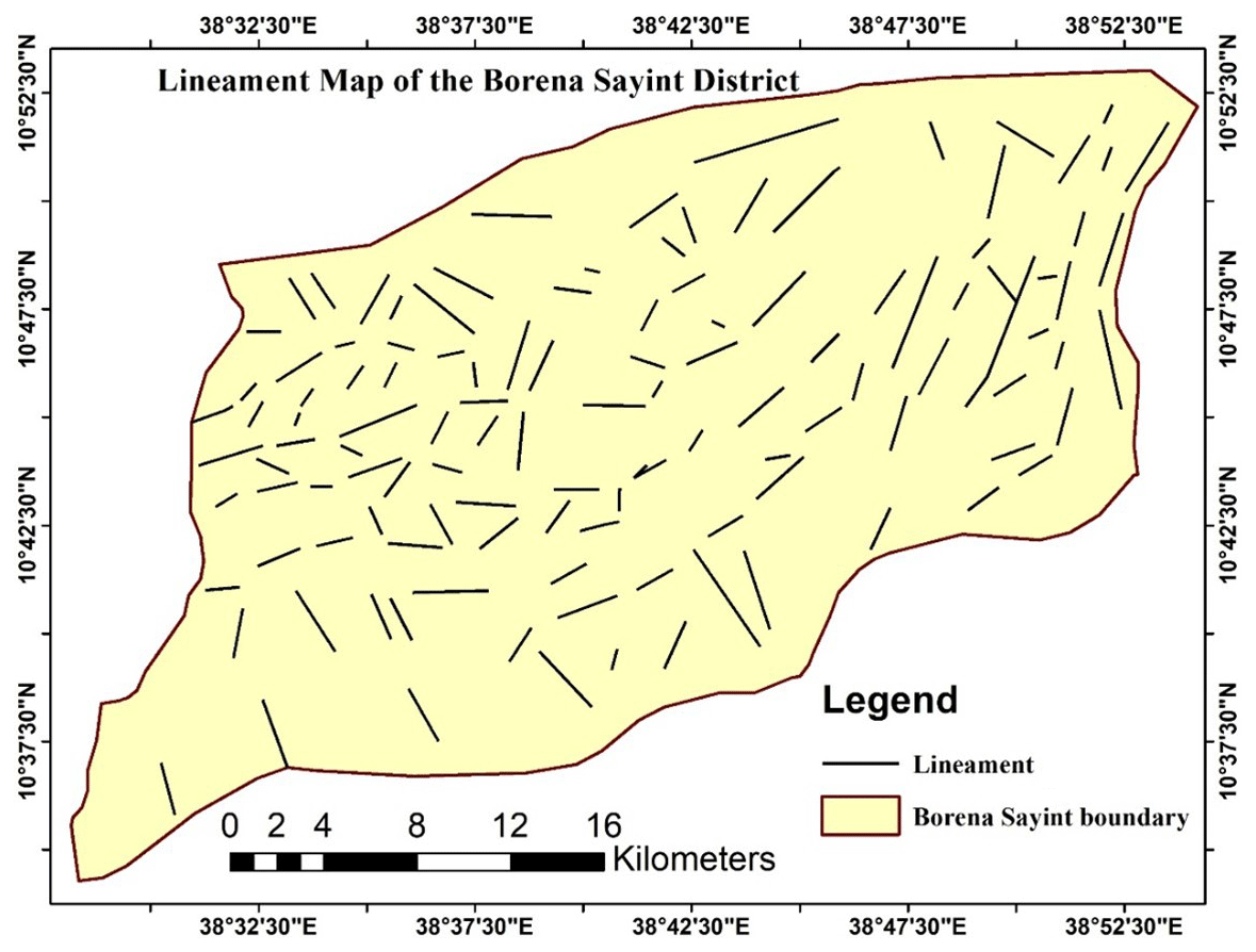
Figure 2The lineament map of the study area (Borena Sayint district).
4.1 Northwestern Ethiopian Plateau
The northwestern Ethiopian Plateau, part of the larger Ethiopian highlands, is a significant region for groundwater sources, providing water for both rural and urban populations (Mamo et al., 2020). The plateau features a complex geological setting, with basaltic volcanic rocks, faulting, and sedimentary layers, all of which affect groundwater availability and movement. This case study examines the geological, hydrological, and environmental factors that influence groundwater potential in the northwestern Ethiopian Plateau (Duguma and Duguma, 2022; Asrade, 2024). Groundwater potential in the volcanic regions of the northwestern Ethiopian Plateau is significantly influenced by geological structures and lithology. In this area, fractured basalts and fault zones act as primary aquifers, while interbedded pyroclastic deposits often serve as aquitards (Kassune et al., 2018). Geophysical surveys and lineament mapping have been effectively utilized to identify areas with high groundwater yields, contributing to the efficient management of water resources in the region (Kebede, 2013; Tesfaye et al., 2020). These techniques have proven particularly useful in locating high-yielding wells, which are often found near major lineaments, highlighting their critical role in groundwater exploration and development (Tesfaye et al., 2020). The northwestern Ethiopian Plateau lies within the northern Main Ethiopian Rift (NMER) of the East African Rift System (EARS), which trends NE–SW and connects with the Afar triple junction. This region is characterized by active tectonic extension and volcanism (WoldeGabriel et al., 1990; Chernet et al., 1998). The NMER region also exhibits significant Quaternary faulting and a complex geomorphological landscape, which further influences groundwater availability (Acocella et al., 2002). Thus, the northwestern Ethiopian Plateau, particularly the Borena Sayint district, has significant groundwater potential due to its unique geological structures, such as volcanic rocks, fault zones, and sedimentary layers. However, this potential is threatened by over-extraction, environmental degradation, and climate change. Sustainable groundwater management strategies, including mapping geological structures, land conservation, and reforestation, are essential to ensure the long-term availability of water for both agricultural and urban needs.
4.2 East African Rift System
The East African Rift System (EARS) is one of the most significant geological features in the world, stretching from the Red Sea in the north to Mozambique in the south. This tectonic plate boundary is characterized by faulting, volcanic activity, and the formation of deep rift valleys. The geological structures in the EARS, such as faults, fractures, volcanic rocks, and sedimentary deposits, play a crucial role in groundwater storage and flow. Understanding the hydrogeology of the region is essential for assessing the groundwater potential, especially in areas where surface water resources are scarce or unreliable. A study by Ayenew (2007) explored the groundwater potential of the EARS by examining the hydrogeological properties of the region, including geological mapping, borehole data, and geophysical surveys. The EARS serves as a key example of how tectonic processes influence groundwater potential in volcanic regions. In this system, faults and fractures enhance secondary porosity, leading to the development of extensive aquifer systems. However, the complex variability in volcanic lithology can present challenges in groundwater exploration (Berhanu et al., 2014). Fault zones in the EARS play a crucial role in groundwater dynamics by acting as recharge pathways, while impermeable volcanic layers limit lateral water flow (Berhanu et al., 2014). Fractures associated with tectonic activity in the rift are particularly important for groundwater recharge and storage. Normal faults, along with the fractures they generate, facilitate recharge and support the storage of water in rift valley aquifers, which is essential for supplying water to arid regions (Berhanu et al., 2014). Additionally, lineaments formed by faults further enhance recharge and water storage in fractured aquifers, making them critical sources of groundwater in these drought-prone areas (Berhanu et al., 2014). Folding in volcanic terrains along the EARS creates alternating layers of permeable and impermeable materials. Recharge primarily occurs along the flanks of anticlines, while synclinal troughs act as natural storage zones. These folded structures are vital for regional water supply, especially in arid zones where surface water is scarce (Berhanu et al., 2014). In Ethiopia, groundwater is a major source of fresh water for domestic, industrial, and agricultural needs, particularly in the absence of reliable surface water. Ethiopia, often referred to as the “Water Tower of Northeast Africa”, is home to numerous rivers that flow from the highlands to lowland areas and to neighbouring countries (Kebede et al., 2005). Given the critical role of groundwater, it is essential to ensure its year-round availability by conducting detailed field investigations, incorporating satellite imagery, and assessing the region's geological structures and geomorphological features (Srinivasa and Jugran, 2003; Mondal et al., 2008). Thus, the East African Rift System offers significant groundwater potential due to its complex geological structures, including volcanic rocks, fault zones, and sedimentary basins. The Borena Sayint district is situated within the East African Rift System, which offers groundwater potential with complex geological structures. However, this potential varies greatly across the region, and careful management is required to prevent over-extraction and degradation. Integrated geological and structural mapping practices, enhanced groundwater recharge, and proper monitoring are essential to ensure the sustainability of groundwater resources in this critical region.
5.1 Fracture-controlled aquifers in volcanic terrain
Studies from other regions have demonstrated how fractures and faults in volcanic rocks can significantly influence groundwater availability. For instance, in areas with basaltic flows, groundwater flow paths are often determined by the presence of intersecting fractures that enhance permeability. These fractures act as conduits, enabling water recharge and storage in aquifers that otherwise lack primary porosity. The Borena Sayint region has many fractures and faults – some examples feature below (Fig. 3). Investigations into tectonically active volcanic regions have revealed the dual role of faults: while some faults enhance groundwater flow, others act as barriers due to mineralization or impermeable fault gouge. Understanding these contrasting behaviours is vital for accurate hydrogeological mapping and resource management.
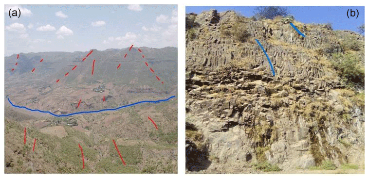
Figure 3The field photographs of local thrust and listric faults (a) and the fractures of columnar joints in the Borena region (b).
5.2 Lineament mapping for groundwater potential
Research on volcanic terrains has utilized remote sensing and GIS-based lineament mapping to identify key structural features indicative of groundwater potential. For example, in geologically complex areas, lineaments aligned with fault zones have been found to host significant groundwater reserves due to increased permeability along these structures. The Borena Sayint district has a dense distribution and different orientations of lineaments; this indicates that the drainage network is associated with fractures (Fig. 3).
6.1 Challenges and limitations
Groundwater exploration in the volcanic terrains of the northwestern Ethiopian Plateau faces several challenges.
-
Data scarcity. A major limitation is the lack of high-resolution geological and geophysical data, which hinders a thorough understanding of the structural controls on groundwater potential. Additionally, the resolution of remote sensing data may not be sufficient to accurately map lineaments, which are critical for groundwater exploration.
-
Structural complexity. The variation in fault orientation, fracture density, and lithological diversity complicates the prediction of groundwater flow paths. The anisotropic nature of fractured and folded aquifers further complicates flow modelling and groundwater movement predictions.
-
Climate variability. Unpredictable rainfall patterns impact recharge rates and groundwater availability. Changes in precipitation due to climate fluctuations affect the reliability of structurally controlled aquifers, especially in regions with complex geological structures. Variations in recharge rates can undermine the consistency of groundwater resources, especially in folded aquifer systems where recharge mechanisms are less predictable.
-
Complex flow paths. In volcanic regions, groundwater movement often follows intricate and unpredictable flow paths, exacerbating difficulties in estimating groundwater availability and potential. The interactions between structural features, such as faults and fractures, and surface and subsurface conditions are not easily modelled.
6.2 Opportunities
-
Advanced mapping techniques. Remote sensing and geographic information systems (GIS) offer valuable tools for mapping and characterizing geological structures like folds, faults, and fractures in volcanic terrains. These technologies enable more accurate identification of groundwater recharge zones and flow pathways. Furthermore, advancements in geophysical techniques, such as electrical resistivity and seismic surveys, allow for better mapping of fault zones and aquifer systems.
-
Integrated approaches. Combining geological, geophysical, and hydrogeological data is a promising strategy for improving groundwater management, especially in complex volcanic regions. Integrated approaches allow for a more comprehensive understanding of the dynamics of fault-controlled aquifers and fractured groundwater systems. By synthesizing multiple datasets, more accurate predictions of groundwater availability and sustainable management strategies can be developed.
-
Innovative tools and algorithms. The use of advanced algorithms to automate the detection and analysis of lineaments and other geological structures can significantly enhance the accuracy and efficiency of groundwater exploration. These innovations also allow for improved mapping of fracture-controlled aquifers, which are critical in volcanic terrains where primary porosity is often absent.
Geological structures are fundamental in determining groundwater dynamics in the volcanic rocks of the northwestern Ethiopian Plateau. This review synthesizes existing research, emphasizing the critical role of faults, fractures, and lithological variations in groundwater potential assessments. The integration of advanced techniques and addressing data gaps will be vital for ensuring sustainable groundwater resource management in the region. Faults have a dual impact on groundwater potential, acting both as conduits and barriers, depending on their structural features and the materials that fill them. A comprehensive understanding of the hydrogeological behaviour of faults is essential for effective groundwater exploration and management. Advances in mapping technologies, geophysics, and remote sensing are increasingly enhancing our ability to assess fault-controlled aquifers and develop sustainable groundwater systems. Fractures are a key component in groundwater systems, particularly in hard-rock and volcanic terrains where primary porosity is often minimal. Their effectiveness as groundwater conduits and storage zones is determined by factors such as orientation, density, and connectivity. Advances in geophysical methods, remote sensing, and hydrogeological studies have significantly improved our understanding of fracture-controlled aquifers, which are vital in many volcanic regions. Lineaments are crucial for exploring groundwater systems, particularly in areas with low primary porosity. These structural features serve as conduits for recharge and groundwater flow, making them prime targets for high-yielding wells and sustainable water resource management. The development of remote sensing, GIS, and geophysical tools has greatly enhanced lineament analysis, providing new opportunities for groundwater exploration in complex geological environments. Folding, particularly in volcanic rocks, significantly impacts aquifer systems by influencing groundwater storage, flow, and recharge. Anticlines and synclines, along with their associated fractures, shape groundwater dynamics, making an understanding of folded volcanic terrains essential for effective exploration. The complexity of these folded systems highlights the importance of integrating structural and lithological data for successful groundwater management. Thus, integrating multidisciplinary approaches – combining geology, geophysics, hydrogeology, remote sensing, and GIS – is crucial for improving groundwater resource management in the volcanic terrains of the northwestern Ethiopian Plateau and similar regions. Addressing current challenges and leveraging new technologies will enable the development of sustainable groundwater resources to meet the needs of growing populations in such areas.
To enhance groundwater potential assessment in the northwestern Ethiopian Plateau, the following steps are recommended.
-
Integrated approaches. Combining geological, geophysical, and hydrological techniques for comprehensive groundwater assessments is crucial. A multidisciplinary approach will provide a more holistic understanding of the region's groundwater systems and improve the accuracy of potential zone identification.
-
High-resolution mapping. The use of advanced remote sensing and GIS technologies is essential for improving the identification of groundwater potential zones. High-resolution imagery, coupled with GIS tools, will help to delineate fault zones, fractures, and other structural features that influence groundwater availability, leading to more accurate and efficient exploration efforts.
-
Long-term monitoring. Establishing monitoring networks across key regions will allow for the ongoing assessment of groundwater systems, particularly to track the impact of climatic fluctuations and structural changes in groundwater recharge and flow patterns. Long-term data will help in predicting future groundwater trends and guide sustainable resource management.
-
Develop robust models. Future research should focus on developing advanced models that integrate structural geology and hydrological and climatic data. These models would provide a dynamic and predictive understanding of groundwater systems, enabling more effective and sustainable groundwater management. Simulating various scenarios, such as climate change or land use modifications, will be essential for ensuring the long-term viability of groundwater resources in volcanic terrains.
The complete dataset supporting the findings of this study is available from the corresponding author upon reasonable request (email: bishawmihret2022@gmail.com).
BM conceptualized the study, designed the methodology, and performed the experimentation and data analysis. AW contributed to writing the article, provided supervision, reviewed the paper, and contributed to critical revisions. Both authors read and approved the final paper.
The contact author has declared that neither of the authors has any competing interests.
Publisher’s note: Copernicus Publications remains neutral with regard to jurisdictional claims made in the text, published maps, institutional affiliations, or any other geographical representation in this paper. While Copernicus Publications makes every effort to include appropriate place names, the final responsibility lies with the authors.
This comprehensive review of the impact of geological structures on groundwater potential assessment in volcanic rocks in the Borena Sayint district, northwestern Ethiopian Plateau, provides valuable insights for groundwater-scarce areas such as the town of Mekaneselam. Although no external funding was specifically allocated to for this work, we gratefully acknowledge the support of the Mekaneselam Town Water and Mine Development Office.
This paper was edited by Xavier Sanchez-Vila and reviewed by two anonymous referees.
Acocella, V., Korme, T., and Salvini, F.: Formation of normal faults along the axial zone of the Ethiopian Rift, J. Struct. Geol., 25, 503–513, https://doi.org/10.1016/s0191-8141(02)00047-0, 2002.
Alehegn, H. A.: Volcano-stratigraphy and petrography of bimodal volcanic rocks suites of Mekane Selam area, northwestern Ethiopian volcanic plateau, B. Volcanol., 86, 19, https://doi.org/10.1007/s00445-024-01705-z, 2024.
Asrade, T. M.: Groundwater potential mapping and its sustainable management using AHP and FR models in the Jedeb watershed, Upper Blue Nile Basin, Ethiopia, Water Sci. Technol., 24, 3617–3638, https://doi.org/10.2166/ws.2024.226, 2024.
Ayenew, T.: Water management problems in the Ethiopian rift: Challenges for development, J. Afr. Earth Sci., 48, 222–236, https://doi.org/10.1016/j.jafrearsci.2006.05.010, 2007.
Ayenew, T., Demlie, M., and Wohnlich, S.: Hydrogeological framework and occurrence of groundwater in the Ethiopian aquifers, J. Afr. Earth Sci., 52, 97–113, https://doi.org/10.1016/j.jafrearsci.2008.06.006, 2008.
Ayenew, T.: Water management problems in the Ethiopian rift: Challenges for development, J. Afr. Earth Sciences, 48, 222–236, https://doi.org/10.1016/j.jafrearsci.2006.05.010, 2007. 2021.
Azagegn, T., Asrat, A., Ayenew, T., and Kebede, S.: Litho-structural control on interbasin groundwater transfer in central Ethiopia, J. Afr. Earth Sci., 101, 383–395, 2015.
Berhanu, B., Seleshi, Y., and Melesse, A.: Surface Water and Groundwater Resources of Ethiopia: Potentials and Challenges of Water Resources Development, Springer, https://doi.org/10.1007/978-3-319-02720-3_6, 2014.
Boccaletti, M., Mazzuoli, R., Bonini, M., Trua, T., and Abebe, B.: Plio-Quaternary volcano tectonic activity in the northern sector of the Main Ethiopian Rift: relationship with oblique rifting, J. Afr. Earth Sci., 29, 679–698, 1999.
Bonini, M., Corti, G., Innocenti, F., Manetti, P., Mazzarini, F., Abebe, T., and Pecskay, Z.: Evolution of the Main Ethiopian Rift in the frame of Afar and Kenya rifts propagation, Tectonics, 24, TC1007, https://doi.org/10.1029/2004tc001680, 2005.
Chernet, T.: Hydrogeology of Ethiopia and Water Resources Development, Hydrolog. Sci. J., 38, 423–437, 1993.
Chernet, T., Hart, W., Aronson, J. L., and Walter, R. C.: New age constraints on the timing of volcanism and tectonism in the northern Ethiopian Rift–southern Afar transition zone (Ethiopia), J. Volcanol. Geoth. Res., 80, 267–280, 1998.
Chorowicz, J. The East African rift system, J. Afr. Earth Sci., 43, 379–410, https://doi.org/10.1016/j.jafrearsci.2005.07.019, 2005.
Chowdhury, A., Jha, M. K., and Chowdary, V. M.: Delineation of groundwater recharge zones and identification of artificial recharge sites in West Medinipur District, West Bengal using RS, GIS, and MCDM techniques, Environ. Earth Sci., 59, 1209–1222, 2009.
Crosbie, R. S., Jolly, I. D., Leaney, F. W., and Petheram, C.: Can the dataset of field based recharge estimates in Australia be used to predict recharge in data-poor areas?, Hydrol. Earth Syst. Sci., 14, 2023–2038, https://doi.org/10.5194/hess-14-2023-2010, 2010.
Davidson, A. and Rex, D. C.: Age of volcanism and rifting in southwestern Ethiopia, Nature, 283, 657–658, 1980.
Duguma, T. A. and Duguma, G. A.: Assessment of Groundwater Potential Zones of Upper Blue Nile River Basin Using Multi-Influencing Factors under GIS and RS Environment: A Case Study on Guder Watersheds, Abay Basin, Oromia Region, Ethiopia, Geofluids, 2022, 1–26, https://doi.org/10.1155/2022/1172039, 2022.
Hardbeck, J. and Hauksson, E.: Fracturing and hydrothermal alterations in normal fault zones, Pure Appl. Geophys., 142, 609–644, 1999.
Jaiswal, R. K., Mukherjee, S., Krishnamurthy, J., and Saxena, R.: Role of remote sensing and GIS techniques for generation of groundwater prospect zones towards rural development – an approach, Int. J. Remote Sens., 24, 993–1008, 2003.
Kassune, M., Tafesse, N. T., and Hagos, M.: Characteristics and productivity of volcanic rock aquifers in Kola Diba Well Field, North-Central Ethiopia, Univ. J. Geosci., 6, 103–113, https://doi.org/10.13189/ujg.2018.060401, 2018.
Kebede, S., Travi, Y., Asrat, A., and Ayenew, T.: Groundwater origin and flow along selected transects in Ethiopian rift volcanic aquifers, Hydrogeol. J., 16, 55–73, https://doi.org/10.1007/s10040-007-0210-0, 2008.
Kebede, S., Travi, Y., Alemayehu, T., and Ayenew, T.: Groundwater recharge, circulation and geochemical evolution in the source region of the Blue Nile River, Appl. Geochem., 20, 1658–1676, 2005.
Kebede, S.: Groundwater in Ethiopia: Features, Numbers and Opportunities, Springer Hydrogeology, Springer, Berlin, Heidelberg, https://doi.org/10.1007/978-3-642-30391-3_7, 2013.
Mamo, M., Zewde, F., and Molla, M.: Groundwater potential of the Northwestern Ethiopian Plateau: Geological and hydrogeological assessment, Hydrogeol. J., 28, 2411–2426, https://doi.org/10.1007/s10040-020-02280-1, 2020.
Mohr, P.: Major volcano-tectonic lineament in the Ethiopian Rift System, Nature, 213, 664–665, 1967.
Mohr, P. and Zanettin, B.: The Ethiopian Flood Basalt Province, in: Continental Flood Basalts, edited by: Macdougall, J. D., Petrology and Structural Geology, vol. 3, Springer, Dordrecht, https://doi.org/10.1007/978-94-015-7805-9_3, 1988.
Mondal, M. S., Pandey, A. C., and Garg, R. D.: Groundwater prospects evaluation based on hydrogeomorphological mapping using high resolution satellite images: A case study in Uttarakhand, J. Indian Soc. Remote, 36, 69–76, https://doi.org/10.1007/s12524-008-0007-1, 2008.
Nilsen, K. H., Sydnes, M., Gudmundsson, A., and Larsen, B. T.: How dykes affect groundwater transport in the northern part of the Oslo Graben, EGS-AGU-EUG Joint assembly, Abstracts from the meeting held in Nice, France, 4 June 2003, 6–11, 2003.
Perrin, J., Ahmed, S., and Hunkeler, D.: The effects of geological heterogeneities and piezometric fluctuations on groundwater flow and chemistry in a hard-rock aquifer, southern India, Hydrogeol. J., 19, 1189–1201, https://doi.org/10.1007/s10040-011-0745-y, 2011.
Srinivasa R. Y. and Jugran, D. K.: Delineation of groundwater potential zones and zones of groundwater quality suitable for domestic purposes using remote sensing and GIS, Hydrolog. Sci. J., 48, 821–833, https://doi.org/10.1623/hysj.48.5.821.51452, 2003.
Seifu, T. K., Ayenew, T., Woldesenbet, T. A., and Alemayehu, T.: Identification of groundwater potential sites in the drought-prone area using geospatial techniques at Fafen-Jerer sub-basin, Ethiopia, Geology Ecology and Landscapes, 8, 410–422, https://doi.org/10.1080/24749508.2022.2141993, 2022.
Tafesse, N. T. and Alemaw, B. F.: Groundwater occurrence, recharge and productivity in Tertiary volcanic rocks of Ethiopia and climate change implications, in: Climate Variability and Change in Africa, edited by: Matondo, J. I., Alemaw, B. F., and Sandwidi, W. J. P., Sustainable Development Goals Series, Springer, Cham, https://doi.org/10.1007/978-3-030-31543-6_8, 2020.
Tesfaye, A., Abdelsalam, M., and Mohammed, M.: Lineament mapping and groundwater potential assessment using remote sensing and GIS: A case study from northwestern Ethiopia, Hydrogeol. J., 28, 2135–2150, 2020.
Tigabu, T. B., Wagner, P. D., Hörmann, G., Kiesel, J., and Fohrer, N.: Climate change impacts on the water and groundwater resources of the Lake Tana Basin, Ethiopia, J. Water Clim. Change, 12, 1544–1563, https://doi.org/10.2166/wcc.2020.126, 2020.
WoldeGabriel, G., Aronson, J. L., and Walter, R. C.: Geology, geochronology and rift basin development in the central sector of the Main Ethiopian Rift, Geol. Soc. Am. Bull., 102, 439–458, 1990.
- Abstract
- Introduction
- Methods for assessing structural influence on groundwater potential
- Role of geological structures in groundwater potential
- Regional structural and hydrogeological setting
- Case studies
- Challenges and opportunities
- Conclusion
- Recommendations and future direction
- Data availability
- Author contributions
- Competing interests
- Disclaimer
- Acknowledgements
- Review statement
- References