the Creative Commons Attribution 4.0 License.
the Creative Commons Attribution 4.0 License.
 | 11 Jul 2025
Hydrological regime index for non-perennial rivers
Pablo Fernando Dornes
Rocío Noelia Comas
The hydrological regime is an integrated basin response that constitutes an established paradigm for environmental flows (e-flows) to mimic as all its components influence aquatic life and consequently fluvial ecosystems. It has been widely described that human activities and climate change modify the natural hydrological regime. These changes in non-permanent rivers generally tend towards greater intermittency, a condition that limits the applicability of hydrological alteration indices. The general aim of the paper is to develop an aggregated impact index, the hydrological regime index (HRI), suitable for flow alteration assessment in non-permanent rivers. The HRI is composed of the flow magnitude attenuation, timing of maximum flow, and interannual flow variation impact factors. The HRI is based on simple conceptualizations and uses monthly flow data, allowing for its applicability in basins with limited information. The HRI was suitable to evaluate the impacts on the river regime of both the Desaguadero–Salado–Chadileuvú–Curacó River, which is severely dammed with intermittent runoff, and the Colorado River, with permanent runoff. In all the cases, the HRI successfully distinguished different impacts on the hydrological regime under natural and low- and high-impoundment conditions. Thus, the HRI constitutes a very useful tool for determining e-flows and quantifying impacts due to water or land use changes.
- Article
(11776 KB) - Full-text XML
- BibTeX
- EndNote


River networks expand and contract in response to the hydrological regime. Hydrological expressions can manifest in one or all of the four dimensions: longitudinal, transversal, vertical, and temporal. These dimensions define the connectivity of the fluvial system throughout the basin (Stanley et al., 1997; Amoros and Bornette, 2002; Gordon et al., 2004; Doering et al., 2007). The hydrological regime of a river can generally, and despite other considerations, be defined in terms of how the flows are distributed throughout the year. A main concern is whether the flows are permanent, intermittent, and/or ephemeral (Sauquet et al., 2021).
Arid and semi-arid basins typically present intermittent runoff in some sectors of the drainage network. This intermittence can be of different duration and extent (Datry et al., 2014; Boulton et al., 2017; Tramblay et al., 2021). Extensive semi-arid basins are hardly fully activated since they usually do not depend solely on a climatic configuration. In contrast, there exist other factors, such as relief or geographical location, that determine the occurrence of precipitation. Therefore, in large complex relief basins, the headwaters of the drainage network are generally located in a mountainous sector that favours the occurrence of precipitation due to the orographic effect. Consequently, the hydrological forcing of the basin typically occurs in the headwaters, and almost none is manifested in the lower part (Viviroli and Weingartner, 2004). Moreover, higher temperatures result in important evapotranspiration losses which accentuate the hydrological deficit of the lower part of the basin. Therefore, runoff is made up of allochthonous flows. Between these events and depending on whether there is groundwater discharge that maintains a base flow, the riverbeds can dry up.
Snow-fed rivers present a well-defined hydrological regime in terms of flow timing and magnitude, with a pronounced peak flow when snow is melting and low winter flow during the snow accumulation phase. However, all these hydrological expressions are strongly modified by flow regulation, usually by the construction of dams to supply water for multiple uses, such as irrigation, recreation, domestic purposes, and hydroelectric generation (Magilligan et al., 2013). These effects are accentuated by the use of low-efficiency irrigation systems, such as gravity-fed surface irrigation practices (McMahon and Finlayson, 2003; Masseroni et al., 2017) and contribute to the reduction in hydrological connectivity within the basin.
In addition, the human-caused impact on the hydrological regime of snow-fed rivers caused by the damming of large reservoirs may be greater than the impact of climate change (Arheimer et al., 2017). This poses a challenge in the necessity to define environmental flows (e-flows). Regardless of the large number of approaches and methods available for their estimation, there exists a consensus that e-flows must mimic the hydrological regime given its structural and functional role in fluvial ecosystems (Richter et al., 1996; Poff et al., 1997). In this sense, hydrological methods that include the description of the natural hydrological regime are the most used ones (Arthington, 2012). However, knowing how the hydrological regime is influenced is also a critical component in the determination of e-flows employing holistic approach methods. Moreover, tools for defining e-flows must be developed within transboundary fluvial systems that exhibit fragmented water governance (Best, 2019; Wineland et al., 2021).
The resulting major disturbances of flow regulation on the hydrological regime may include changes in the magnitude of flows (i.e. flow attenuation), time delay of peak flows, loss of intra-annual variability, and reduction or loss of the hydrological connectivity in the basin (Callow and Smettem, 2009; Steward et al., 2012; Magilligan et al., 2013; Torabi Haghighi et al., 2014). Hydropower and flood management typically reduce flow variability and can affect the timing of peak flows, while irrigation management usually reduces flow magnitude due to crop water use.
Several conceptualizations and metrics have been proposed to assess the effects of dams on the hydrological regime (e.g. Richter et al., 1996, 1997, 1998; Olden and Poff, 2003; Magilligan and Nislow, 2005; Poff et al., 2007; Gao et al., 2009; Radinger et al., 2018; Döll and Schmied, 2012; Richter et al., 2012; Torabi Haghighi and Køble, 2013; Torabi Haghighi et al., 2014; Singh and Jain, 2020; Zhou et al., 2020; Sauquet et al., 2021; Arthington, 2022; De Girolamo et al., 2022; McManamay et al., 2022; Wang et al., 2022). In general, these indices of hydrological alteration (IHA) include many parameters whose statistics serve as indicators of flow alteration and may be used as operation rules for reservoirs when downstream flows are analysed (Harman and Stewardson, 2005). However, the intercorrelation among the parameters may result in statistical redundancy (Poff and Zimmerman, 2010), and different methodologies, such as principal component analysis (PCA), have been applied to identify subsets of more representative hydrological parameters (Gao et al., 2009). Furthermore, the complexities involved in the explicit use of these parameters in optimization models for reservoir operation have led to the proposal of subset of parameters based on the flow duration curve (FDC) to define seasonal ecodeficit/ecosurplus (Vogel et al., 2007) and the development of different linear and nonlinear strategies to constrain these parameters (Wang et al., 2015; Li et al., 2018).
In semi-arid regions, the usual scarcity of data, such as the lack of detailed and distributed information (e.g. discontinuous flow records and lack of daily data) and the intermittent flow conditions, limit the use of IHA (Leone et al., 2023; Gómez-Navarro et al., 2024). Indeed, indices based only on flow statistics, including, for example, the interquartile variation range (IQR), the coefficient of variation (CV), or the FDC, used as proxies for the seasonality of flows, among other parameters, may not be suitable when no-flow conditions are present. They require very detailed information that is not always available or is irrelevant to the dominant processes occurring in the basin. For example, the typical IHA parameters, such as the number of high or low pulses and means of all positive or negative differences between consecutive daily means, do not necessarily reflect the presence of allochthonous flows or interactions with groundwater. Similarly, those parameters based on complex theoretical functions of flow distribution have limited representativeness when runoff is not of a natural origin (e.g. only dam discharges and drainage flows). Therefore, new approaches to evaluate the modification of hydrological regimens in non-perennial rivers are needed: first and as indicated, the necessity to mathematically resolve relationships that adjust to intermittent flow scenarios, and second, to possess the capability to implement the index in a temporal and/or spatially distributed manner to assess the hydrological connectivity in extensive basins, which is a fundamentally important factor for the quantification of e-flows.
In this context, the Desaguadero–Salado–Chadileuvú–Curacó (DSCC) River provides a representative case study because it is an extensive semi-arid basin that is severely dammed and has undergone noticeable changes in its hydrological expression over the past century, mainly due to the fragmented water governance along its transboundary water systems (Dornes et al., 2016). The fluvial system of the DSCC River develops through a highly heterogeneous relief, where winter snowfall in the mountain area constitutes the main hydrological input function with a variability strongly influenced by the El Niño–Southern Oscillation (ENSO) climate pattern (Compagnucci and Vargas, 1998; Compagnucci and Araneo, 2007; Montecinos and Aceituno, 2003; Masiokas et al., 2006; Prieto et al., 2001; Araneo and Compagnucci, 2008; Barros et al., 2008; Cortés et al., 2011; Penalba and Rivera, 2016; Rivera et al., 2017; Lauro et al., 2019).
This configuration determines a complex and nonlinear hydrological basin response, which is modified by high-impoundment conditions. Thus, those years characterized as the warm or positive phase of ENSO (El Niño) led to heavy snowfall and above-normal runoff that may exceed the storage capacity of the reservoirs and have a lesser impact on the hydrological regime downstream of the reservoirs due to increased basin connectivity. On the contrary, years characterized as the negative phase of ENSO (La Niña) result in less snowfall and lower-than-normal streamflow, which strongly modify the hydrological regime downstream since almost no flow exceeds the storage capacity of the reservoirs; hence, flows do not activate the lower part of the DSCC River basin.
Since the flow regime is an integrated basin response, a comprehensive approach should be used to evaluate its temporal and spatial distribution under both permanent and non-permanent flow conditions in areas with data scarcity. The hydrological metric must be capable of describing the flow under natural (i.e. slightly modified) and modified conditions to varying degrees. For example, in the tributaries of the DSCC River, the index must possess the ability to adequately discriminate between the hydrological conditions observed upstream and downstream of the main hydraulic structures. In the DSCC River, additional hydrological characteristics emerge that must be suitably assessed, such as river reaches with or without interaction with groundwater, contributions from tributaries with modified flows, and influence of wetland storage on the hydrological regime. These characteristics also have an important impact on the hydrological connectivity of the basin.
Therefore, to address the deficiency wherein numerous metrics inadequately assessed the alterations in the hydrological regime under no-flow conditions, the objective of this study was to investigate the effect of flow regulation on the hydrological river regime by the development of a simple and dimensionless index that is applicable across different regimes but especially under no-flow conditions with minimal data requirements.
The DSCC River basin is the largest basin that is located entirely in Argentina. The DSCC River basin is located in the central-west part of Argentina lying to the east of the of the Cordillera de los Andes (CA) mountain range with a north–south orientation (27°47′ S–38°50′ S). The basin belongs to the Colorado (CO) River that drains into the Atlantic Ocean (Fig. 1). It encompasses partially or totally the provinces of Catamarca, La Rioja, San Juan, Mendoza, San Luis, and La Pampa. The total area is approximately 315 000 km2 and includes the sub-basins of the Vinchina–Bermejo (VB), Jáchal (JL), San Juan (SJ), Mendoza (MZ), Tunuyán (TY), Diamante (DT), and Atuel (AT) rivers. The DSCC River basin located in the CA piedmont is defined by mountain ranges such as the Cordillera Principal, the Cordillera Frontal, and the Precordillera to the west and north and the Sierras Orientales and Sierras Pampeanas to the east, whereas the lower basin is developed on flat terrain as part of the occidental area of the Pampean region (Ramos, 1999). This orographic configuration determines that the CA is the headwater of the DSCC River basin, where winter precipitation due to the orographic lifting of Pacific air masses by the mountains constitutes the principal hydrological forcing of the basin (Bruniard, 1986). The rest of the basin is isolated from the influences of wet air masses driven by the extratropical high-pressure systems of the Atlantic and Pacific oceans, a condition that results in an arid climate to the north and semi-arid to the south (Prohaska, 1976). This configuration generates a north–south precipitation gradient that ranges between values around 100 to 350 mm per year respectively; however, this precipitation does not contribute to the average hydrological expression of the lower basin of the DSCC River, which is strongly defined by the allochthonous snowmelt runoff from the CA (Dornes et al., 2016).
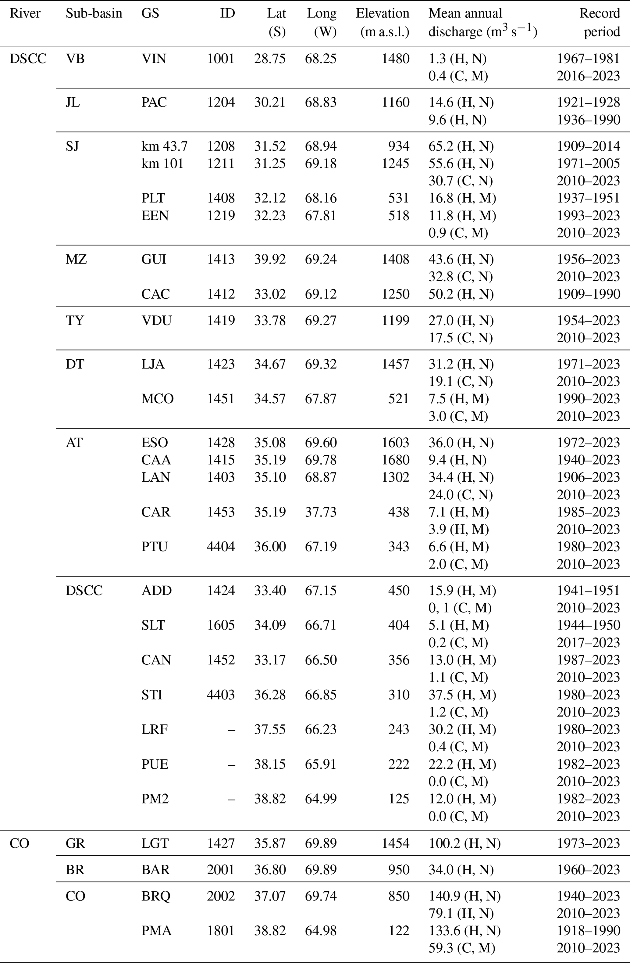
The tributaries drain the eastern slope of the CA through well-defined valleys and canyons towards the piedmont. All the tributaries have a defined snow-fed hydrological regimen given that neither the glacier cover at the middle CA nor the summer precipitation is significant. Northern sub-basins have considerably less runoff than the central and southern sub-basins, as is the case of the VB River with a mean discharge value around 1 m3 s−1 and JL River with an average annual flow of 10 m3 s−1. The SJ River is the tributary with the greatest discharge, with a mean annual flow of 65 m3 s−1, which is a consequence of the development of the basin over a large part of the CA covering a mountain front of more than 200 km. It is followed by the MZ River with 44 m3 s−1, whereas the TY, DT, and AT have 27, 31, and 34 m3 s−1 respectively. The tributaries show both a great interannual flow variability that is consistent with varying snowmelt processes occurring in a complex mountain environment and a defined synchronicity with above- and below-average flows strongly related to positive and negative ENSO episodes (Compagnucci and Vargas, 1998; Aceituno and Vidal, 1990; Waylen and Caviedes, 1990; Masiokas et al., 2006; Araneo and Villalba, 2014). The maximum flow magnitudes observed in the 1980s and 1992, 1995, 2005, and 2006, and to a lesser degree in 2008, were associated with El Niño episodes. On the other hand, the last decade showed very low flow values according to the dominance of negative ENSO phases (La Niña), with the exclusion of 2015 being classified as an El Niño episode that resulted in average flow values (Table 1). As a consequence, lesser natural flows are seen in all the tributaries for the current conditions.
Tributary streams reach their confluence with the DSCC River usually through depositional sediments forming alluvial fans, where the reduction in the terrain slope and the discharge of alluvial local aquifers led to the occurrence of extensive wetlands. The DSCC River initiates as the outlet of the Lagunas de Guanacahe (LG) wetland, which is fed by the VB, SJ, and MZ rivers (see Fig. 1); however, as these tributaries are highly dammed, the DSCC River has modified flows, showing a tendency for increased intermittency, particularly in its lower basin. The DSCC River follows a north–south trajectory along approximately 1 450 km until its mouth in the CO River at the Pichi Mahuida point in La Pampa province (38°49′ S and 64°59′ W) and is distinguished by being an axial collector that receives on its right bank all its aforementioned tributaries and connecting important wetlands (Bereciartua et al., 2009; Chiesa et al., 2015), such as LG, Bañados del Tunuyán (BT), Bañados del Atuel (BA), and Lagunas de Puelches (LP). Between these wetlands and until its mouth in the CO River, the DSCC River has different names. Thus, it is called Desaguadero River (DSCC-I) between LG and BT, Salado River (DSCC-II) between BT and BA, Chadileuvú River (DSCC-III) between BA and LP, and Curacó River (DSCC-IV) from LP to the CO River.
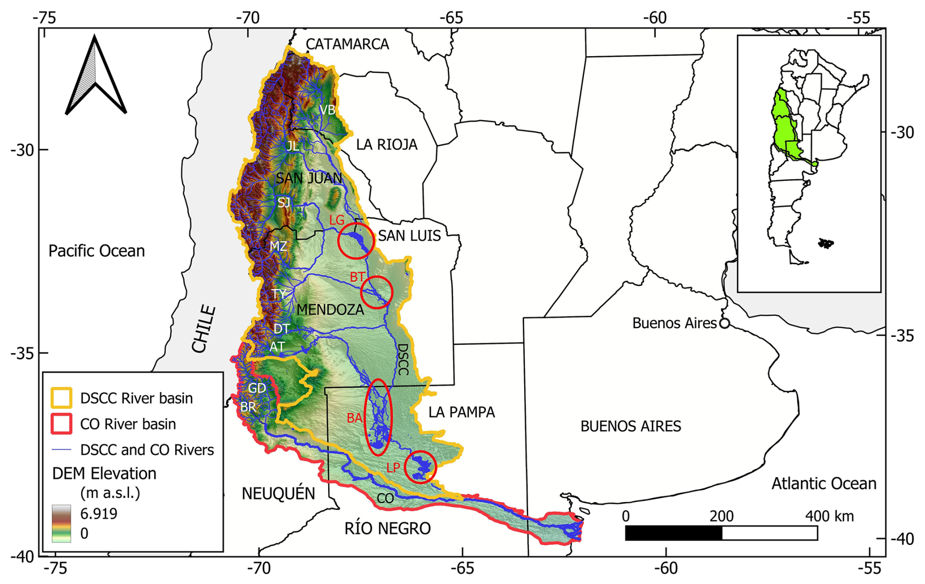
Figure 1Location of the Desaguadero–Salado–Chadileuvú–Curacó (DSCC) and Colorado (CO) river basins. VB: Vinchina–Bermejo River, JL: Jachal River, SJ: San Juan River, MZ: Mendoza River, TY: Tunuyán River, DT: Diamante River, AT: Atuel River, GD: Grande River, and BR: Barrancas River. Circles and ellipse indicate the main wetlands: Lagunas de Guanacache (LG), Bañados del Tunuyán (BT), Bañados del Atuel (BA), and Lagunas de Puelches (LP).
The wetlands of the DSCC River are epigenetic as a result of the fluvial contributions with null groundwater discharge. They are characterized by extensive flooded areas with numerous channels and lagoons and acquire an ecological relevance due to their location in a semi-arid region and for being hydrological regulation nodes of the basin. The LG, BT, and BA wetlands are located at the distal part of extensive alluvial fans developed at the confluence of the corresponding tributary with the DSCC River, therefore their hydrological expression depends more on the flow contribution of the tributary than on the DSCC River. On the other hand, the LP wetland is characterized by the presence of extensive lagoons (e.g. La Brava, La Leona, La Julia, La Dulce, Urrelauquen, and La Amarga), all of them linked by the DSCC River.
Table 1Mean annual discharge for the gauging stations (GSs) in the Desaguadero–Salado–Chadileuvú–Curacó (DSCC), and Colorado (CO) rivers. H: historical period, C: current period, N: natural flow (upstream of the reservoirs), and M: modified flow (downstream of the reservoirs). VB: Vinchina–Bermejo River, JL: Jáchal River, SJ: San Juan River, MZ: Mendoza River, TY: Tunuyán River, AT: Atuel River, GD: Grande River, and BR: Barrancas River. VIN: Vinchina, PAC: Pachimoco, PLT: Paso las Tunitas, EEN: El Encón, GUI: Guido, VDU: Valle de Uco, LJA: La Jaula, MCO: Monte Comán, ESO: El Sosneado, CAA: Cañada Ancha, LAN: La Angostura, CAR: Carmensa, PTU: Puesto Ugalde, ADD: Arcos del Desaguadero, SLT: Salto de la Tosca, CAN: Canalejas, STI: Santa Isabel, LRF: La Reforma, PUE: Puelches, PM2: Pichi Mahuida 2, LGR: La Gotera, BAR: Barrancas, BRQ: Buta Ranquil, and PMA: Pichi Mahuida.
The DSCC River basin has 12 large reservoirs, all located on its tributaries (Fig. 2 and Table 2). Currently, El Tambolar (ETA) on the SJ River is under construction, and there are more planned, such as El Baqueano (EBA) on the DT River. They were all designed for hydroelectric production and irrigation objectives, not for basin flood management. The prevalent use of inefficient gravity-fed surface irrigation systems determines that irrigation demands are unusually high with respect to natural supply (Llop et al., 2013). As a result of these impoundments and reservoir operation, none of the tributaries contributes in the natural regimen to the DSCC River. Further, in the DSCC River, two small dams (Azud Norte, AZN, and Azud Sur, AZS) were built to generate impoundment conditions and prevent erosion in the LG wetland. The CO River has the Dique Punto Unido (DPT) diversion dam used for irrigation and water consumption and the Casa de Piedra (CDP) reservoir that regulates the different water allocations in the lower basin.
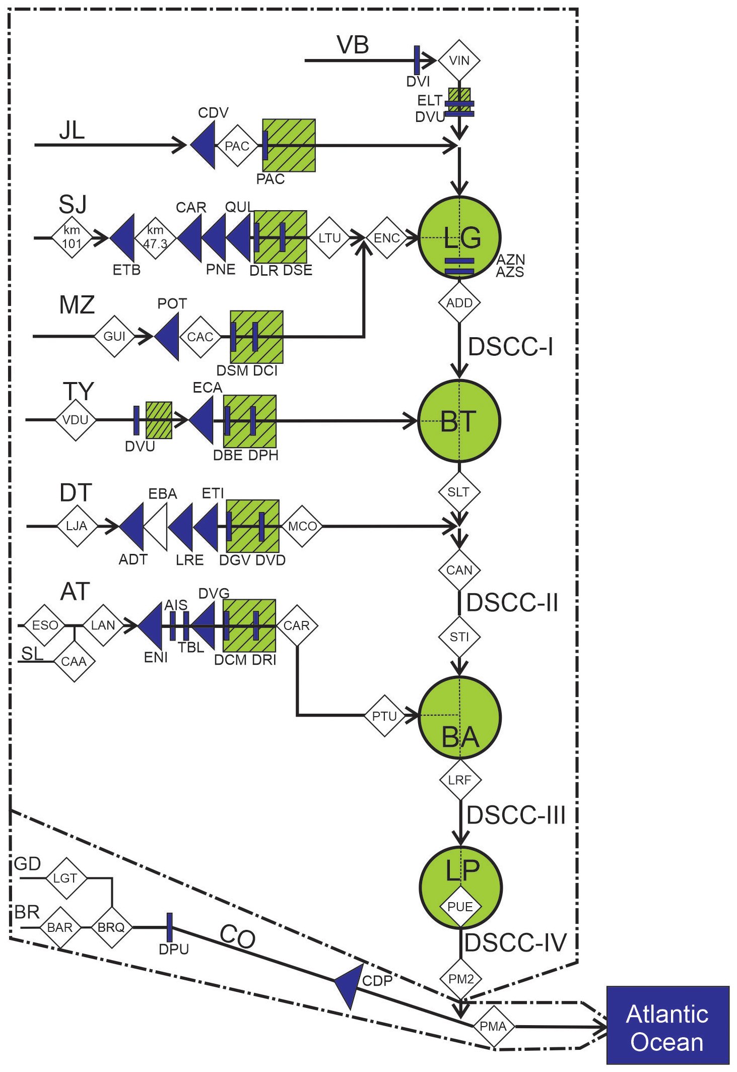
Figure 2Schematic diagram of the Desaguadero–Salado–Chadileuvú–Curacó (DSCC) River and Colorado (CO) River basins showing the location of its reaches, tributaries, wetlands, gauging stations, reservoirs, diversions dams, and irrigated areas. DSCC-I: Desaguadero River, DSCC-I: Salado River, DSCC-III: Chadileuvú River, and DSCC-IV: Curacó River. Circle: wetlands. Dark triangles: main reservoirs. White triangle: projected reservoir. Rectangles: diversion or flood control dams. Shaded squares: irrigation areas. Diamonds: gauging stations. More descriptions are depicted in Fig. 1 and Tables 1 and 2.
The runoff in the DSCC River is allochthonous due to the reduced rainfall that dominates the lower basin with high-flow records strongly associated with El Niño episodes, such as in the 1980s, when the DSCC River drainage network was fully active with discharges to the CO River. The historical information is not synchronous, given that it is generally only available during runoff periods, and it indicates highly modified annual hydrographs along the DSCC River. The current situation with lower snowfalls shows an even more severe hydrological condition exhibiting nearly no flow throughout its length (Fig. 3). Thus, as a consequence of the described flow regulation in the tributaries, the DSCC River remains dry and does not contribute to the CO River. Furthermore, no groundwater discharge is observed from outside the alluvial plain. Groundwater flow follows the regional gradient of the river, and it is majorly constrained to the alluvial plain of the DSCC River, where the phreatic aquifer is fed by fluvial recharge (Páez Campos and Dornes, 2021).
Table 2Sub-basins, reservoirs, and diversion dams in the Desaguadero–Salado–Chadileuvú–Curacó (DSCC) River basin and in the Colorado (CO) River basin. Elevation was obtained by the digital elevation model (DEM) (USGS, 2024a).
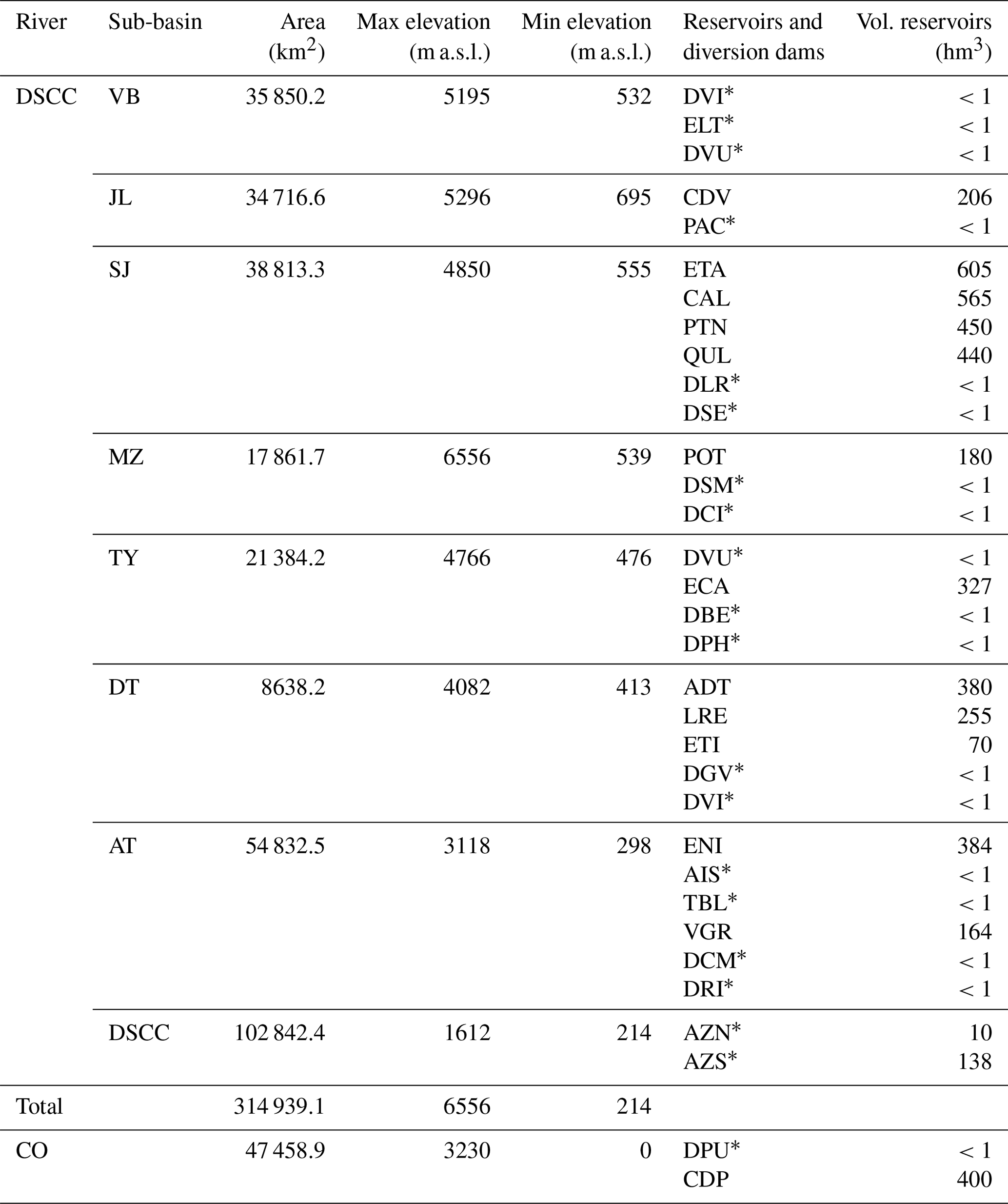
* Diversion and flood control dam. DVI: Dique Vinchina, ELT: Embalse Lateral, DVU: Dique Villa Unión, CDV: Cuesta del Viento, PAC: Pachimoco, ETA: El Tambolar, CAL: Caracoles, PTN: Punta Negra, QUL: Quebrada de Ullúm, DLR: Dique La Rosa, DSE: Dique San Emiliano, POT: Potrerillos, DSM: Dique San Martín, DCI: Dique Cipolletti, DVU: Dique Valle de Uco, ECA: El Carrizal, DBE: Dique Benegas, DPH: Dique Phillps, ADT: Agua del Toro, LRE: Los Reyunos, ETI: El Tigre, DGV: Dique Galileo Vitali, DVI: Dique Vidalino, ENI: El Nihuil, AIS: Aisol, TBL: Tierras Blancas, VGR: Valle Grande, DCM: Dique Canal Marginal, DRI: Dique Rincón del Indio, AZN: Azud Norte, AZS: Azud Sur, DPU: Dique Punto Unido, and CDP: Casa de Piedra. VB: Vinchina-Bermejo River, JL: Jáchal River, SJ: San Juan River, MZ: Mendoza River, TY: Yunuyán River, DT: Diamante River, and AT: Atuel River.
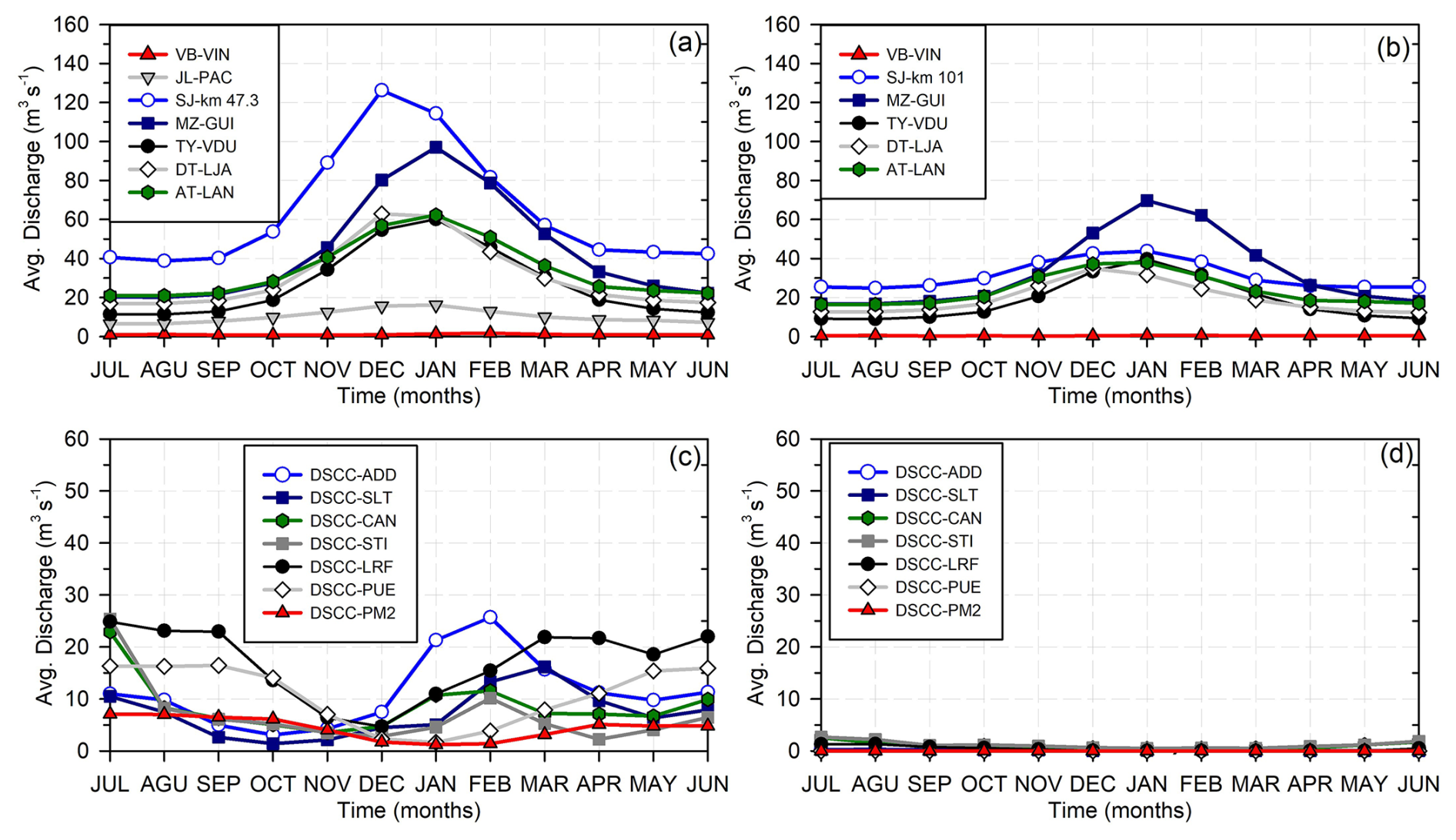
Figure 3Annual hydrographs of the Desaguadero–Salado–Chadileuvú–Curacó (DSCC) River. (a) Historical flows in natural regime of the tributaries of the DSCC. (b) Current flows (2010–2023) in natural regime of the tributaries of the DSCC. (c) Historical flows in modified regime of the DSCC. (d) Current flows (2010–2023) in the modified regime of the DSCC River. Rivers, gauging stations, and historical and actual periods are detailed in Table 1.
3.1 Development of the hydrological regime index
To evaluate the effects of flow regulation on the hydrological river regime in different hydrological conditions but mainly in intermittent rivers, a single impact index, the hydrological regime index (HRI), was developed. The HRI incorporates the main components of the hydrological regime (i.e. flow attenuation, time shifting of maximum flow, and interannual variability). It is based on the comparison between the annual distribution of monthly flow records in natural or slightly modified with modified regimes (i.e. upstream vs. downstream of a reservoir), which represent the long-term pattern of water flow and therefore the hydrological regime. Since the HRI is not a site-specific measurement, this approach makes it suitable for no-flow conditions and to evaluate the limitation or loss of hydrological connectivity due to flow impoundment along the river network.
To facilitate the comparison of the flow records and similarly to the concept of the unit river approach used by Torabi Haghighi and Køble (2013), the flows are scaled to have an equal flow rate (U) of 100 million m3 per year. Therefore, the scaled monthly flows (Qsm) are calculated as the contribution to the annual flow following Eq. (1):
where Qm is the monthly flow and Qa is the annual average flow rate of the river. This scaling allows rivers with different flow rates to be compared in terms of the annual hydrological regime. A uniform regulated or dry river has a Qsm of exactly 8.333 million m3 of total flow.
Similarly to the approach applied by Torabi Haghighi et al. (2014) but using simpler functions adapted to intermittent flows to describe the time lag and interannual variability, the HRI is detailed as in Eq. (2):
where HRI varies between 1 (natural or unmodified flow) and 0 (completely modified flow). MIF stands for magnitude impact factor, TIF for timing impact factor, and VIF for variation impact factor.
MIF is of equal importance to the sum of TIF and VIF because flow magnitude is the main controlling factor of the hydrological regime. For example, for no-flow conditions, MIF is 0, and HRI must be 0 (i.e. completely modified flow). The maximum impact of TIF or VIF is 0, and their sum is 1 when no changes in timing and intra-annual variability are observed.
Flows downstream of multipurpose reservoirs typically result in values of lower magnitude due to different water consumption. The extreme cases are when there are no downstream flows (MIF = 0) or when the upstream and downstream flows are equal (MIF = 1). Since MIF is calculated based on average values over long or representative periods, it is very rare to have larger flow values downstream of a reservoir. However, if this is the case, MIF is set to be equal to 1. Therefore, MIF was calculated as the ratio between modified and natural flows as in Eq. (3):
where QaM is the mean annual modified flow (e.g. downstream of the reservoir) and QaN is the mean annual flow in natural regime (e.g. upstream of the reservoir).
The TIF was calculated based on the time delay in monthly maximum discharge (TD) along the hydrological year between the natural (e.g. upstream of the reservoir) and modified flows. The maximum TD value is 6 months, corresponding to a seasonal inverted maximum flow; therefore, the following conditionals are applied:
where TQmN.max and TQmM.max are the time (i.e. month number within the hydrological year) of occurrence of the monthly natural and modified maximum flow respectively.
To scale the TIF to a maximum value of 0.5 (i.e. natural flow) and a minimum value of 0 (i.e. maximum TD) applying a linear relationship with a slope of 0.0833, it is calculated as follows (Eq. 6):
Regardless of the type and operation of the reservoir, the resulting downstream flow is more uniform, which represents a loss of interannual variability. Complete regulation implies a constant flow rate, which can be equal to the average annual flow rate or have a lower value of up to a flow rate equal to zero. Therefore, the VIF is calculated based on the annual sum of the deviations from a straight or constant flow line for both the natural and modified flows. These values are the monthly regime index (MRI) and are summed in the annual regime index (ARI). Both the MRI and ARI are computed using the scaled hydrographs (Eq. 1); therefore, if Qm is constant (i.e. uniform regime), Qsm=8.333, and MRI = ARI = 0. The following conditions are applied:
The annual regime index for natural flows (ARIN) typically varies between 30 and 55 for snow-fed regimes. Modified flows can have values of the annual regime index (ARIM) between 0 (i.e. equal value all the months) and a maximum value of 91.67 when a dry river has runoff occurring only in one month (i.e. ephemeral river). To scale the VIF between 0.5 (i.e. natural flows) and a minimum value of 0 (i.e. maximum flow regime modification), the relation regime index (RRI) between the natural and modified flows is defined in Eq. (10):
The following conditions must be considered. If the observed annual flow variability downstream is lower than the one upstream (i.e. RRI <1), the RRI value is scaled so that VIF varies between 0 and 0.5. On the other hand, if the flow variability downstream is larger than the one upstream (i.e. RRI >1), it means that a drastic modification occurred to the streamflow given by dam management or by the contribution of no natural flow, such as drainage discharges from irrigation areas. In this case, VIF equals 0. To avoid a drastic change between values of RRI = 1 (VIF 0.5) and RRI >1 (VIF = 0), a transition function was introduced to consider an increase in the non-natural variability of less than 20 % as indicated in the following equations, Eqs. (11), (12), and (13):
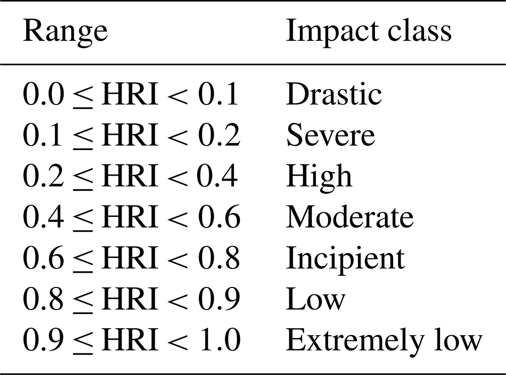
Finally, seven different impact classes were defined for different values of HRI using percentiles as indicated in Table 3. The two classes at the lower and upper extremes have an extension of 10 % in relation to the 20 % that the middle classes present. This was implemented to highlight severe and drastic impacts or low-impact conditions respectively.
3.2 Data set
The HRI was applied to both the tributaries and the primary channel of the DSCC River. Moreover, to validate the applicability of the index, the HRI was also applied to the CO River with a defined hydrological connectivity throughout the basin and permanent runoff in natural regimen and with both low- and high-impoundment conditions.
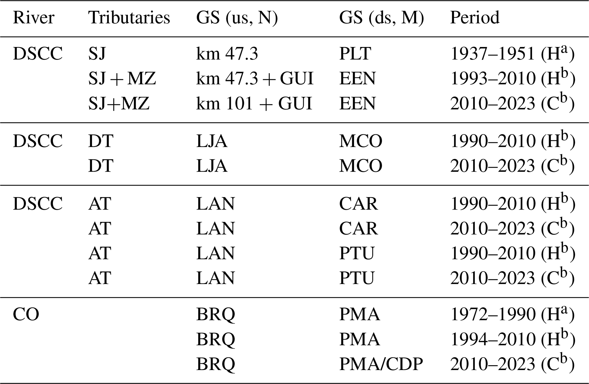
In the tributaries, natural flows were evaluated upstream of the main reservoirs by comparing at least two gauging stations. They were selected for their proximity to ensure that there are no significant contributions from streams or interactions with groundwater. If the distances were larger, the criterion was based on the allochthonous nature of the flows, meaning that there were no evident contributions in the analysed section that cause increased flows at the downstream gauging station. Based on the above and the availability of information, the MZ River at GUI and CAC (1956–1990) and AT River at ESO with the added contribution of the Salado (SL) River at CAA respectively to the records downstream in LAN (1972–2003) were evaluated. In the CO River basin, the HRI for natural flows was implemented in the headwaters (LGT and BAR) with respect to the monthly flows registered in BRQ and in the main channel between BRQ and PMA gauging stations for the 1976–2011 and 1940–1971 periods respectively.
The tributary modified flows observed downstream of the main reservoirs were analysed by comparing them to natural flow records registered upstream. In the comparison, we differentiate between periods characterized by low-impoundment conditions (i.e. reservoirs with storage capacity <2 hm3; see Table 2), during which water for irrigation was primarily sourced from diversion and small dams, and periods characterized by high-impoundment conditions (i.e. reservoirs with greater storage capacity, >100 hm3) that represent current conditions (Table 4). In this case, only in the SJ River (km 47.3 vs. PLT) was it possible to evaluate the effect of low-impoundment conditions from 1937 to 1950 and in the CO River (BRQ vs. PMA) for the 1940–1971 period. For the high-impoundment conditions, the modification of the hydrological regime was analysed in the majority of the tributaries of the DSCC River (SJ, MZ, DT, and AT) in two periods, the historical available records until 2010 and the 2010–2023 time series that represent both the current impoundment and climate conditions. In the SJ River, the sum of natural or slightly modified flows at km 47.3 or km 101 and in the MZ River at GUI were compared with those observed downstream of QUL, PTN, CAL, ETA, and POT reservoirs in the SJ at EEN (modified flow) for the two indicated periods, 1993–2010 and 2010–2023, respectively. In the DT River, the natural or slightly modified flows at LJA were compared with modified flows recorded downstream of ETI, LRE, and ADT reservoirs in MOC for the historical and current periods, while in the AT River, the natural or slightly modified flows at LAN were contrasted with the modified flows registered downstream of VGR and ENI reservoirs at CAR and PTU for the 1985–2023 and 1980–2010 time series respectively, splitting the analyses in the two previously indicated periods.
A similar approach was applied in the CO River, where for low-impoundment conditions, natural or slightly modified monthly flows recorded in BRQ were compared with the modified observed in PMA downstream of the DPU diversion dam for the 1972–1990 period. For high-impoundment conditions, flows recorded in BRQ were contrasted with flows in PMA downstream of CDP reservoir for the available historical (1994–2010) and current (2010–2023) periods. Missing records in PMA between 2015–2018 and 2023 were completed with CDP flow discharges, while the flow contributions of the DSCC River in the 1980s were subtracted.
Table 4Detail of the gauging stations (GSs) located upstream (us) and downstream (ds) of reservoirs and periods with common available data used to calculate the hydrological regime index (HRI) for modified flows in the Desaguadero–Salado–Chadileuvú–Curacó (DSCC) River and the Colorado (CO) River. San Juan (SJ) River at km 47.3, km 101, Paso las Tunitas (PLT), and El Encón (EEN); Mendoza (MZ) River at Guido (GUI), Diamante (DT) River at La Jaula (LJA), and Monte Comán (MCO); Atuel (AT) River at La Angostura (LAN), Carmensa (CAR), and Puesto Ugalde (PTU); and CO River at Buta Ranquil (BRQ), Pichi Mahuida (PMA), and Casa de Piedra (CDP).
N and M denote natural and modified flows, a and b low- and high-impoundment conditions, and H and C historical and current conditions respectively.
In the DSCC River, the lack of records with natural flows and the intermittence of the current flows determined that the application of the HRI relied on a temporal comparison under high-impoundment conditions. If 1988, which activated the entire fluvial system, is considered an approximate representation of the natural or slightly modified regimen, it is possible to compare it with current flow conditions (2010–2023). Logically, 1988 represented a year of extraordinary flows that yield greater attenuations when compared to the current flows. Consequently, the 1982–1992 time series was utilized as the reference period, given that its records encompass both flood years and low-water years. As a result of data availability, the STI, LRF, PUE, and PM2 gauging stations located in the lower DSCC River basin were used.
The information is available at the national hydrological information system (SNIH, 2024), in the hydrological database of La Pampa province (BDH, 2024), and in the Colorado River Basin Interjurisdictional Committee (COIRCO, 2024).
4.1 Hydrological regime index in natural flow
The performance of the HRI was first evaluated for flows in the natural regimes in both the tributaries of the DSCC River and in the CO River (Fig. 4). In this case, the average monthly flows recorded at a given gauging station were compared with those recorded upstream.
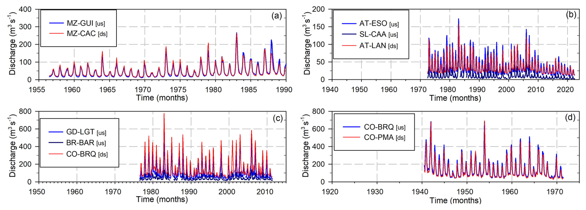
Figure 4Chronological monthly flows in natural regime of the tributaries of the Desaguadero–Salado–Chadileuvú–Curacó (DSCC) River and in the Colorado (CO) River used to calculate the hydrological regime index (HRI). us: upstream, ds: downstream. (a) Mendoza (MZ) River at GUI and CAC, (b) Atuel (AT) River at ESN, Salado (SL) River at CAA and AT River at LAN, (c) Grande (GD) River at LGT, Barrancas (BR) River at BAR, and CO River at BRQ, and (d) CO River at BRQ and PMA.
For all the rivers analysed in natural regime, high HRI values indicating low impacts were observed (Table 5 and Fig. 5). In the MZ River, the comparison between flows recorded in GUI and CAC gauging stations for the period from 1956–1990, prior to the construction of the POT reservoir, showed that there was no flow attenuation between GUI and CAC gauging stations. CAC had a slightly higher average annual flow value, possibly as a result of the contribution of streams between both stations, since they were located approximately 17.5 km from each other. Therefore, MIF was set to be equal to 1. There was no time delay (TIF = 0.5), and a slightly lesser interannual flow variation was seen in CAC (VIF = 0.476). The resulting HRI of 0.98 indicates an extremely low modification of the hydrological regime.
In the AT River, the analysis was carried out from the monthly flows recorded in ESO with the added contributions from its tributary, the SL River in CAA, and compared with the flow records in LAN located downstream of both gauging stations. The two rivers join in the place called Las Juntas, situated at the foot of an extensive alluvial fan, where significant flow losses occur and therefore lower flows are recorded in LAN. As a result, there was more attenuation of the flow magnitude (MIF = 0.785); however, smaller impacts were seen in the timing and flow variability (TIF = 0.417 and VIF = 0.386). The HRI equals 0.63 and indicates an incipient modification of the hydrological regime.
In the headwater of the CO River basin, the monthly flows for the 1976–2011 period of the GD River in LGT along with those of the BR River in BAR were contrasted with the flows recorded at the BRQ gauging station, located 160 and 37 km downstream respectively (see Fig. 2). Due to contributions from small streams in the river section between the gauging stations analysed, the average annual flow is 5 % larger downstream, in BRQ. Therefore, no flow attenuation was observed, and the MIF equalled 1. In addition, no temporal differences were observed in the maximum flows (TIF = 0.5) and a slightly lower interannual variability (VIF = 0.475) was seen. The HRI equals 0.98 and shows that the hydrological regime in natural conditions presented an extremely low modification between the analysed gauging stations. In the CO River, the monthly flows recorded in BRQ were compared with those of the PMA gauging station located 150 km downstream for the 1940–1971 period. Flows downstream showed a low-magnitude attenuation that resulted in a MIF = 0.883. The timing of maximum flows did not change (TIF = 0.5), and the loss of interannual variability was very low (VIF = 0.493). These impact factors resulted in an HRI = 0.88 that indicates a low impact on the hydrological regime for the CO River in the natural regime.
Table 5Hydrological regime index (HRI) for natural flows in the tributaries of the Desaguadero–Salado–Chadileuvú–Curacó (DSCC) River and in the Colorado (CO) River. Qma: mean annual flow. us: upstream, ds: downstream. MIF: magnitude impact factor, TIF: timing impact factor, and VIF: variation impact factor. Mendoza (MZ) River at Guido (GUI) (us) and Cacheuta (CAC) (ds), Atuel (AT) River at El Sosneado (ESO) (us), Salado (SL) River at Cañada Ancha (CAA) (us), AT River at La Angostura (LAN) (ds), Grande (GD) River at La Gotera (LGT) (us), Barrancas (BR) River at Barrancas (BAR) (us), CO River at Buta Ranquil (BRQ) (ds and us), and Pichi Mahuida (PMA) (ds).
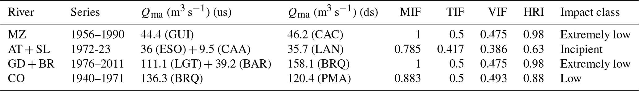
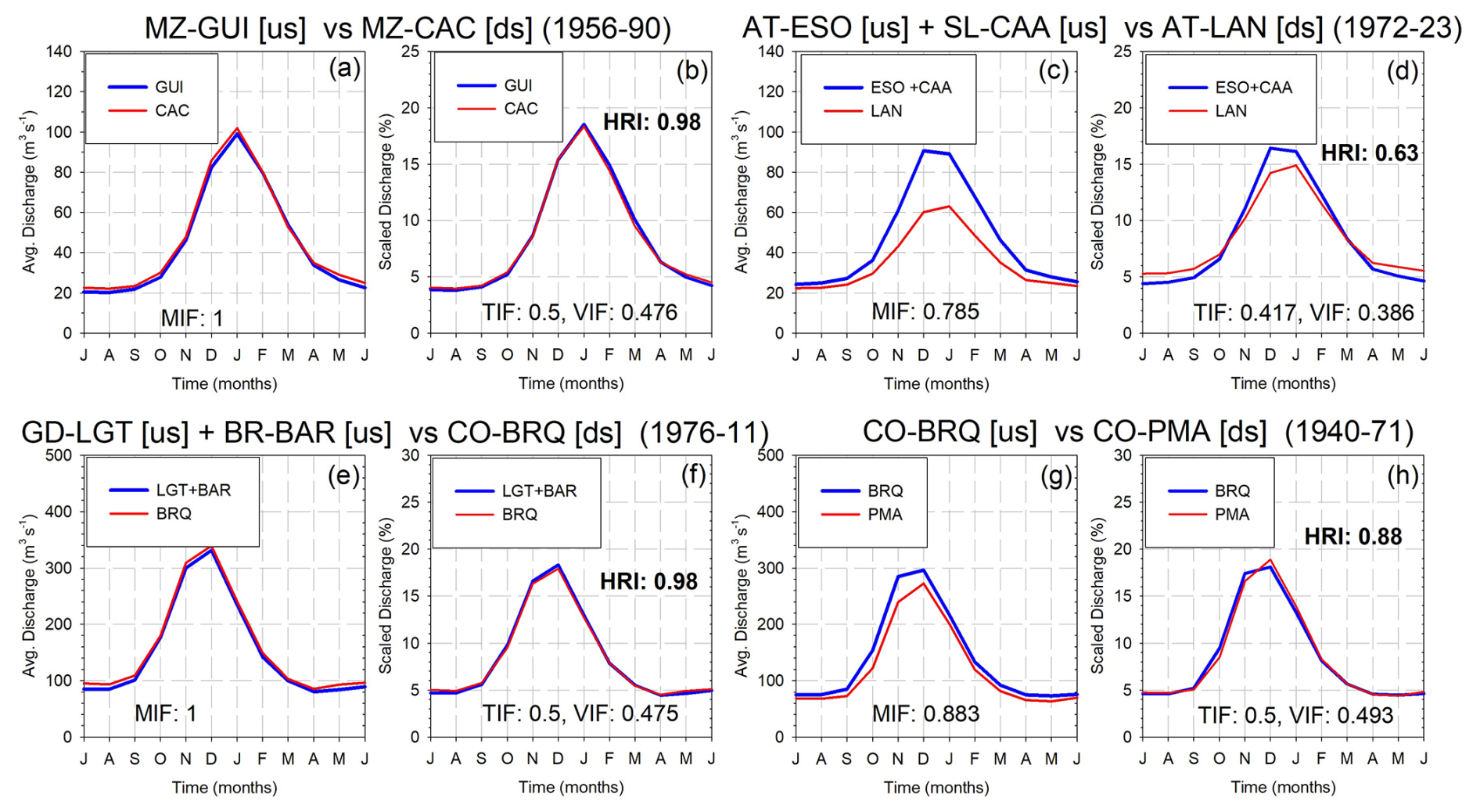
Figure 5Hydrological regime index (HRI) for flows in natural regime in the tributaries of the Desaguadero–Salado–Chadileuvú–Curacó (DSCC) River and in the Colorado (CO) River. Annual and scaled hydrographs between gauging stations located upstream (us) and downstream (ds). MIF: magnitude impact factor, TIF: timing impact factor, and VIF: variation impact factor. (a, b) Mendoza (MZ) River at GUI and CAC, (c, d) Atuel (AT) River at ESO, Salado (SL) River at CAA, AT River at LAN, (e, f) Grande (GD) River at LGT, Barrancas (BR) River at BAR, CO River at BRQ, and (g, h) CO River at BRQ and PMA.
4.2 Hydrological regime index with low-impoundment conditions
In the DSCC River basin, most of the main reservoirs were built on its tributaries in the second half of the 20th century. Previously, there were only small water diversion dams with little or no impoundment conditions (see Table 2). The present analysis is thus restricted to the periods with flow records upstream and downstream of the diversion dams. This is the case with the SJ River with flow records in km 47.3 and LTU located upstream and downstream DLR and DSE diversion dams respectively for the period from 1937–1951. Since the period under analysis was characterized by a significant flood in 1941/42 that contrasted with the low flows observed before and after, the HRI was determined for the entire period (1937–1951), for the period with high flows (1941–1946), and for the periods with low flows (1937–1940 and 1946–1951). In the CO river, the analysis was applied by comparing the average monthly flows in BRQ with those registered in the PMA gauging station located downstream of the DPU diversion dam for the 1972–1990 period. PMA is located 550 and 360 km downstream of BRQ and DPU respectively (Fig. 6).
Figure 6Chronological monthly flows in natural (N) and modified (M) regimes used to calculate the hydrological regime index (HRI) with low-impoundment conditions in the tributaries of the Desaguadero–Salado–Chadileuvú–Curacó (DSCC) River and in the Colorado (CO) River. (a) San Juan (SJ) River at km 47.3 and PLT gauging stations upstream and downstream of Dique la Rosa (DLR) and Dique San Emiliano (DSE) diversion dams respectively and (b) CO River at BRQ and PMA gauging stations upstream and downstream of Dique Punto Unido (DPU) diversion dam respectively.
Table 6 and Fig. 7 show the impact factors for low-impoundment conditions. The HRI was 0.24 in the SJ River for the entire period, with MIF = 0.270, TIF = 0.417, and VIF = 0.489, which indicates a high impact on the hydrological regime downstream of the SLR diversion dam. However, if the pre- and post-flood conditions that better represent the average flow conditions are evaluated, the attenuation in flow magnitude is very large (MIF = 0.057). No differences in timing were observed (TIF = 0.417); however, these conditions were contrasted with the drastic loss of natural variability downstream (i.e. increase in unnatural variability), where very low flows, present only during the summer season, differed from the almost-null and zero flows registered during the remainder of the year (VIF = 0). These impact factors determined an HRI = 0.02 that illustrates a drastic impact condition. Finally, if solely the period with the highest flows is examined, MIF = 0.371, TIF = 0.417, and VIF = 0.449. This results in an HRI = 0.32 that corresponds to an equally high-impact condition to the hydrological regime.
In the CO River, downstream flows in PMA showed a low-magnitude attenuation downstream that resulted in a MIF = 0.879. The timing of maximum flows did not change (TIF = 0.5), and the loss of interannual variability was very low (VIF = 0.464). These impact factors resulted in an HRI = 0.85 that indicates a low impact on the hydrological regime.
Table 6Hydrological regime index (HRI) for modified flows with low-impoundment conditions in a tributary of the Desaguadero–Salado–Chadileuvú–Curacó (DSCC) River and in the Colorado (CO) River. Qma: mean annual flow. N: natural flow, M: modified flow. us: upstream, ds: downstream. MIF: magnitude impact factor, TIF: timing impact factor, and VIF: variation impact factor. San Juan (SJ) River at km 47.3 and Paso las Tunitas (PLT) located upstream and downstream of Dique de la Roza (DLR) and Dique San Emiliano (DSA) diversion dams respectively. CO River at Buta Ranquil (BRQ) and Pichi Mahuida (PMA) located upstream and downstream of Dique Punto Unido (DPU) diversion dam respectively.
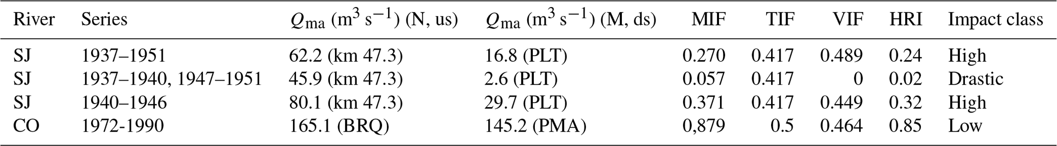
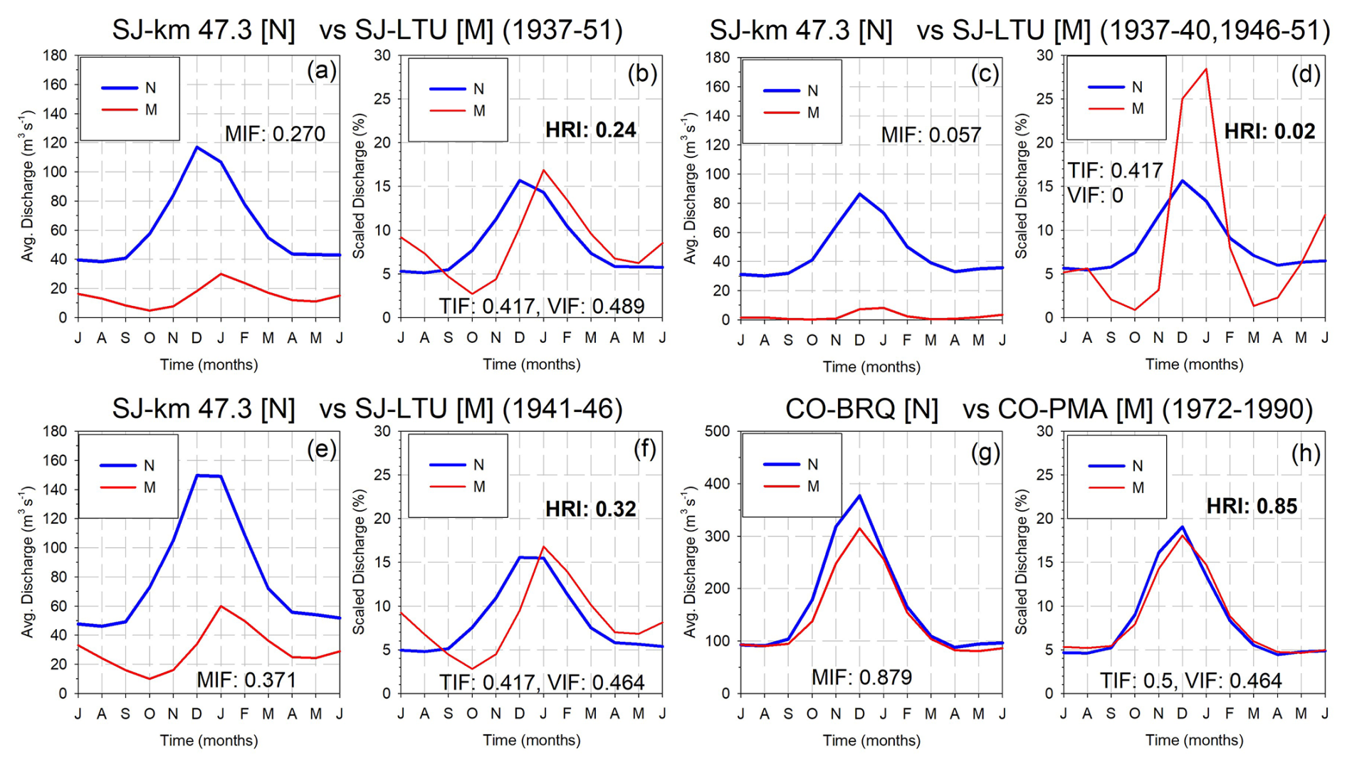
Figure 7Hydrological regime index (HRI) for low-impoundment conditions. Annual and scaled hydrographs in natural (N) and modified (M) flows. MIF: magnitude impact factor, TIF: timing impact factor, and VIF: variation impact factor. (a–b) San Juan (SJ) River at km 47-3 (N) and PLT (M) complete period (1937–1951), (c–d) SJ River at km 47-3 (N) and PLT (M) low-flow periods (1937–1940 and 1946–1951), (e–f) SJ River at km 47-3 (N) and PLT (M) high-flow period (1941–1946), and (g–h) Colorado (CO) River at BRQ (N) and PMA (M) (1972–1990).
4.3 Hydrological regime index with high-impoundment conditions
The comparison of flow conditions upstream (i.e. natural regime) and downstream (i.e. modified regime) of the main reservoirs in the tributaries of the DSCC River and in the CO River revealed a different degree of modification of the hydrological regime (Fig. 8). In the tributaries, downstream of the reservoirs and adjacent to irrigation areas, runoff is intermittent. However, this runoff is not natural and stems from both direct and diffuse drainage contributions of irrigation surpluses due to the use of highly inefficient gravity irrigation systems. Therefore, flows show significant attenuation or an intermittent condition with an inverted hydrological regime as they predominantly occur in winter. This runoff vanishes downstream and does not contribute to the DSCC River.
Furthermore, in the current period, characterized by reduced natural flows, the aforementioned effects are more pronounced. The reduction in flows exhibited a marked synchronicity in all the tributaries of the DSCC River and in the CO River, where, consistently, lower snowfall amounts in the CA were attributable to the predominance of La Niña episodes.
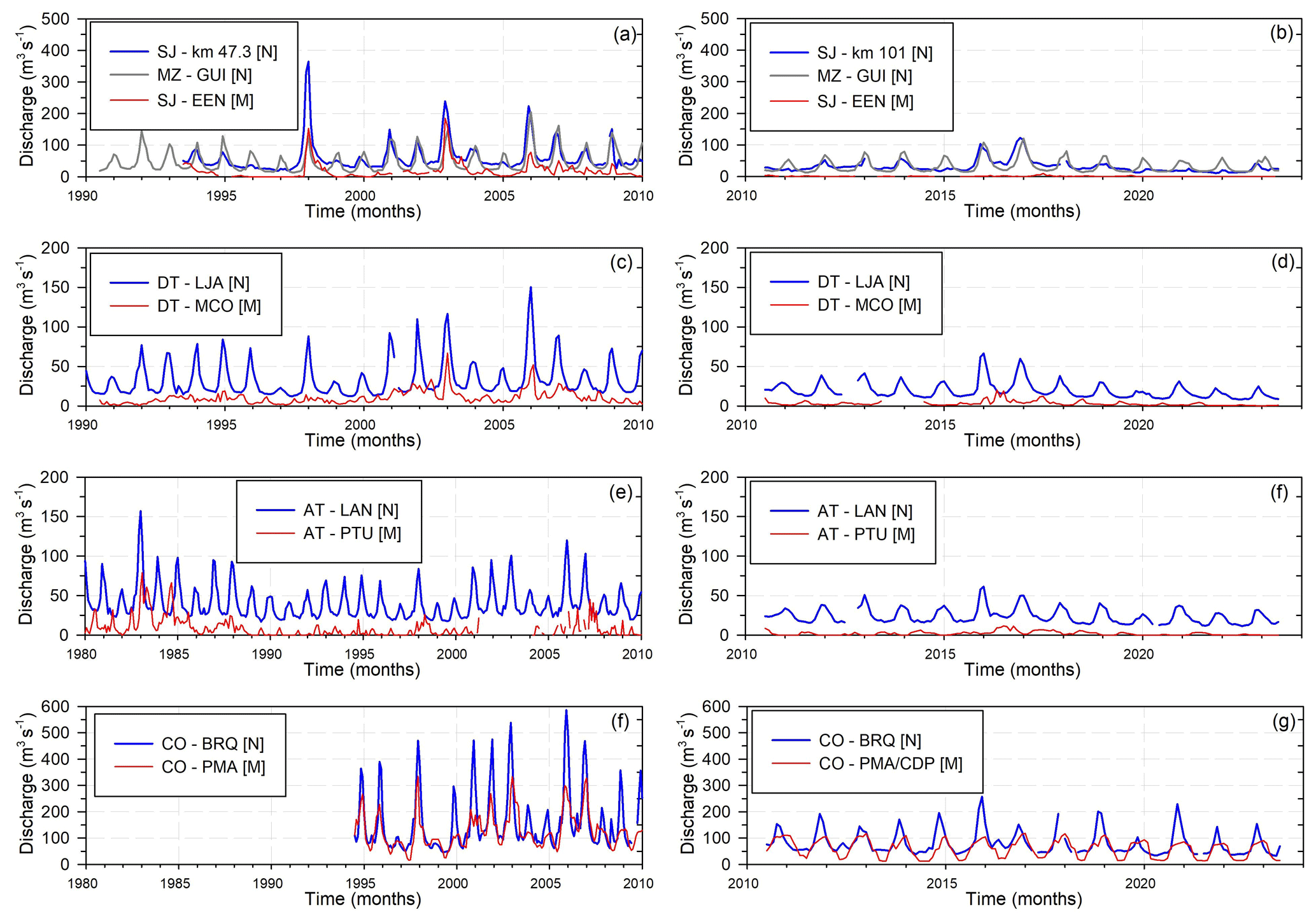
Figure 8Chronological monthly flows in natural (N) and modified (M) regime of the tributaries of the Desaguadero–Salado–Chadileuvú–Curacó (DSCC) River and in the Colorado (CO) River for available historical (H) and current (C) (2010–2023) periods. (a) San Juan (SJ) River at km 47.3 (H, N), Mendoza (MZ) River at GUI (H, N) and SJ River at EEN (H, M), (b) SJ at km 101 (C, N), MZ River at GUI (C, N) and SJ River at EEN (C, M), (c) Diamante (DT) River at LJA (H, N) and MCO (H, M), (d) DT River at LJA (C, N) and MCO (C, M), (e) Atuel (AT) River at LAN (H, N) and PTU (H, M), (e) AT River at LAN (C, N) and PTU (C, M), (f) CO River at BRQ (H, N) and PMA (H, M), (g) CO River at BRQ (C, N) and PMA completed with Casa de Piedra (CDP) reservoir discharges (C, M).
The HRI values determined by comparing the flows upstream and downstream of the main reservoirs for the historical and current periods are shown in Table 7 and Fig. 9. For the SJ River, the natural flows at km 47.3 with the added contribution of the MZ River in GUI were contrasted with flows observed in the SJ River in EEN located downstream the of the QUL, DLR, and DSE (in the SJ River), andPOT, DSM, and DCI (in the MZ River) reservoirs and diversion dams for the 1993–2010 period. In this condition, the mayor impact factor was the strong flow magnitude attenuation (MIF = 0.174). In contrast, no changes in the maximum flow timing (TIF = 0.5) and lower effects on the interannual variability were observed (VIF = 0.449). The resulting HRI = 0.15 indicates a severe impact on the hydrological regime. However, when current conditions are analysed (2010–2023), the lower natural flows and the inclusion of the PTN and CAL reservoirs with the construction ETA in the SJ River, along with lack of contributions from the MZ River, exacerbated the effects downstream, in EEN. Flows became intermittent (MIF = 0.014), with a strong effect in the timing given by the prevalence of winter flows (TIF = 0) that resulted in a non-natural variability (VIF = 0). Consequently, the hydrological regime impact is classified as drastic with an HRI = 0.
In the DT River, flows upstream the ADT, LRE, ETI, DGV, and DVI reservoirs and diversion dams showed, downstream in MCO, a high impact on the flow regime for the historical period (HRI = 0.24) due to values of MIF = 0.369, TIF = 0.417, and VIF = 0.225. For current conditions with no changes in the impoundment conditions, the lower natural flows resulted in a stronger attenuation (MIF = 0.157), a marked delay of the occurrence of maximum flows (TIF = 0.08), and a larger and non-natural interannual variability due to the prevalence of winter flows (VIF = 0). The resulting HRI = 0.16 indicates drastic effects on the hydrological regime in MCO.
In the AT River, flows downstream of the ENI, AIS, TBL, VGR, and DRI reservoirs and diversion dams showed, for the historical period, a severe impact on its hydrological regime in CAR with HRI = 0.1. The marked attenuation (MIF = 0.239) and the dominance of winter flows (TIF = 0) were the main factors modifying the hydrological regime. For the current conditions, the inclusion of the DCM diversion dam and the lower natural flows worsened the impact on the hydrological regime downstream of the reservoirs. The HRI degraded to a value of 0.07, indicating a drastic flow regime modification. In PTU, located 120 km downstream of CAR, the HRI for the historical period equalled 0.01, which indicates a drastic impact on the hydrological regime, showing significant flow attenuation and changes in timing and interannual variability (MIF = 0.128, TIF = 0, and VIF = 0.110). For current conditions, the flow intermittence is even more pronounced, which is given by MIF = 0.083, TIF = 0, and VIF = 0 values, leading to an HRI = 0 that indicates a maximum drastic impact.
The CO River showed, for the historical period, an incipient impact (HRI = 0.62) on the hydrological regime of the flows in PMA, located downstream of the CDP and DPU reservoir and diversion dam. The flow attenuation resulted in a MIF = 0.791, and no changes were registered in the timing (TIF = 0.5); however, a marked reduction in the interannual flow variability (VIF = 0.279) was observed, presumably due to the filling of the CDP reservoir at the beginning of the period considered. In the current condition, with the same impoundment infrastructure, the lower natural flows resulted in a similar attenuation (MIF = 0.759) and greater delay in maximum monthly values (TIF = 0.333) but a lower impact on the flow variability (VIF = 0.423). The resulting HRI equalled 0.57, indicating a moderate effect on the natural hydrological regimen in PMA.
Table 7Hydrological regime index (HRI) of the tributaries of the Desaguadero–Salado–Chadileuvú–Curacó (DSCC) River and the Colorado (CO) River with high-impoundment conditions for available historical and current (2010–2023) periods. Qma: mean annual flow. N: natural flows, (M) modified flows. us: upstream, ds: downstream. MIF: magnitude impact factor, TIF: timing impact factor, and VIF: variation impact factor. San Juan (SJ) River at km 47.3, km 101 and El Encón (EEN), Mendoza (MZ) River at Guido (GUI) and Cacheuta (CAC), Diamante (DT) River at La Jaula (LJA) and Monte Comán (MCO), Atuel (AT) River at La Angostura (LAN), Carmensa (CAR) and Puesto Ugalde (PTU), and CO River at Buta Ranquil (BRQ), Pichi Mahuida, (PMA) and Casa de Piedra (CDP).
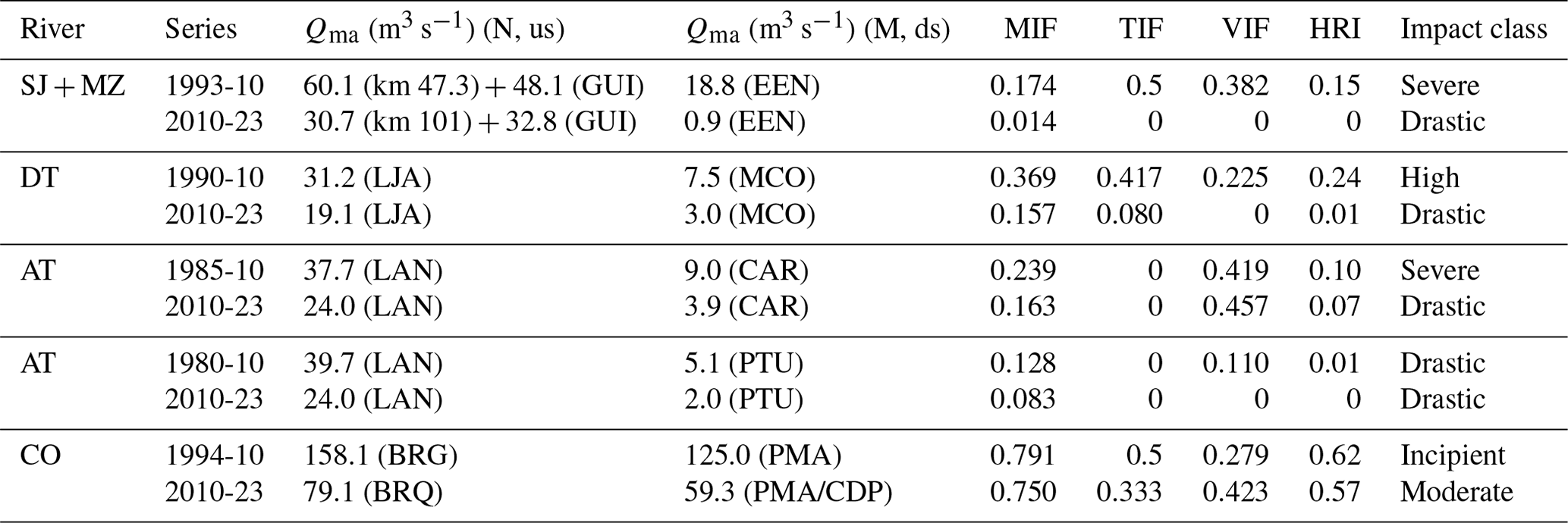
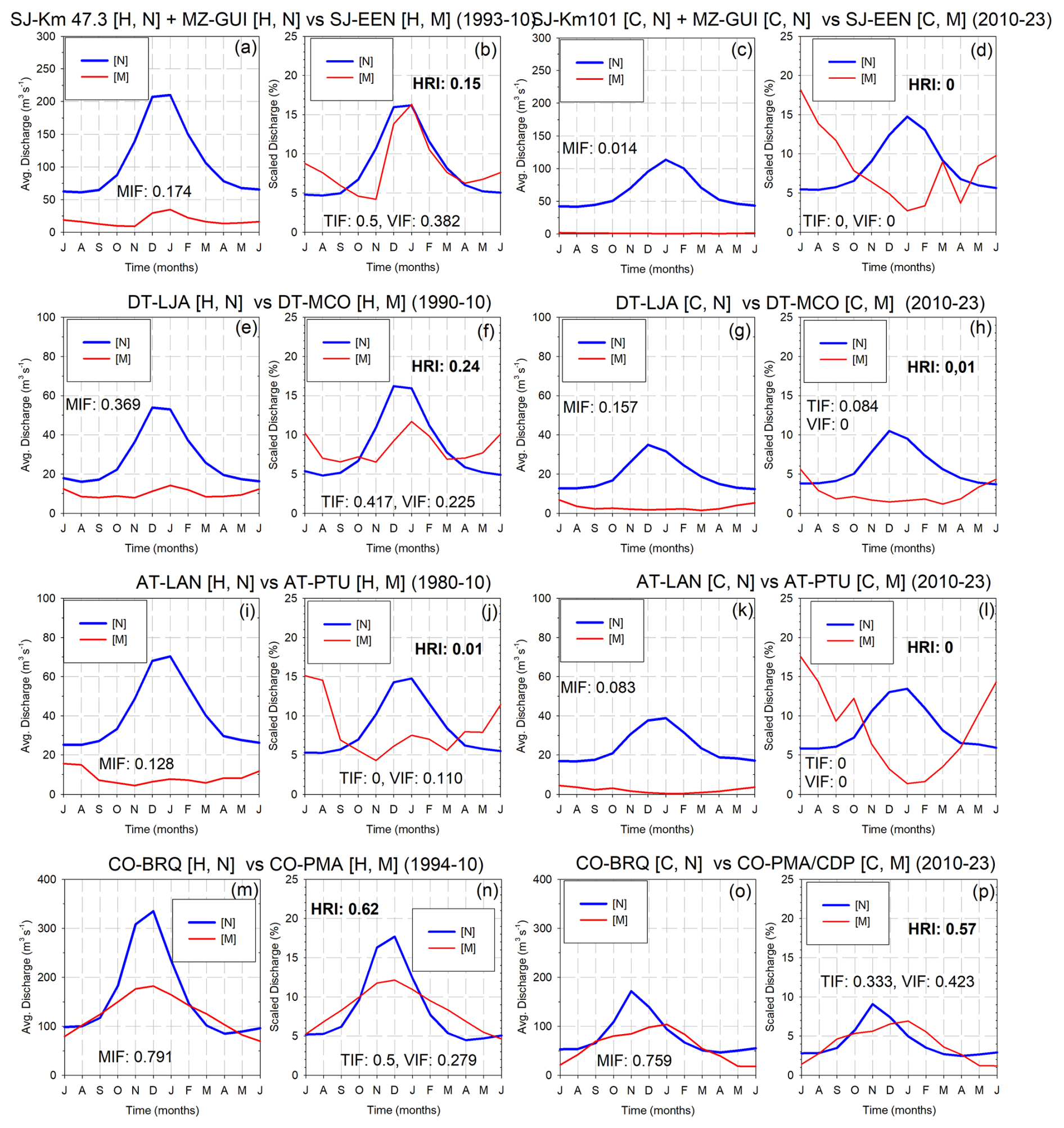
Figure 9Hydrological regime index (HRI) of the tributaries of the Desaguadero–Salado–Chadileuvú–Curacó (DSCC) River and in the Colorado (CO) River with high-impoundment conditions for available historical (H) and current (C) (2010–2023) periods. Annual and scaled hydrographs in natural (N) and modified (M) flows. MIF: magnitude impact factor, TIF: timing impact factor, and VIF: variation impact factor. (a–b) San Juan (SJ) River at SJ km 47.3 (H, N) with the Mendoza (MZ) River at MZ-GUI (H, N) vs. SJ-EEN (H, M), (c–d) SJ km 101 (C, N) with MZ-GUI (C, N) vs. SJ-EEN (C, M), (e–f) Diamante (DT) River at DT-LJA (H, N) vs. DT-MCO (H, M), (g–h) DT-LJA (C, N) vs. DT-MCO (C, M), (i–j) Atuel (AT) River at AT-LAN (H, N) vs. AT-PTU (H, M), k–l) AT-LAN (C, N) versus AT-PTU (C, M), (m–n) CO River at Buta Ranquil (BRQ) (H, N) vs. Pichi Mahuida (PMA) (H, M), and (o–p) CO River at Buta Ranquil (BRQ) (C, N) vs. Pichi Mahuida (PMA) and Casa de Piedra (C, M).
Although the DSCC River does not have large reservoirs, the severe flow regulation on its tributaries results in the DSCC River being dry. Flows are only present as runoff pulses associated with ENSO episodes that eventually exceed the storage capacity of the reservoirs, as occurred during the 1980s and particularly in 1988 when the fluvial network of the DSCC River was entirely activated. Similar effects, though to a lesser extent, were observed in 1998 and 2006. Figure 10 depicts the longest time series available of monthly flows, located in the lower part of the DSCC River basin. Based on these hydrological expressions, both the historical or reference period (1982–1992) with flows in the natural regime and the current period (2010–2023) characterized by their intermittent and very attenuated flow conditions, were analysed.
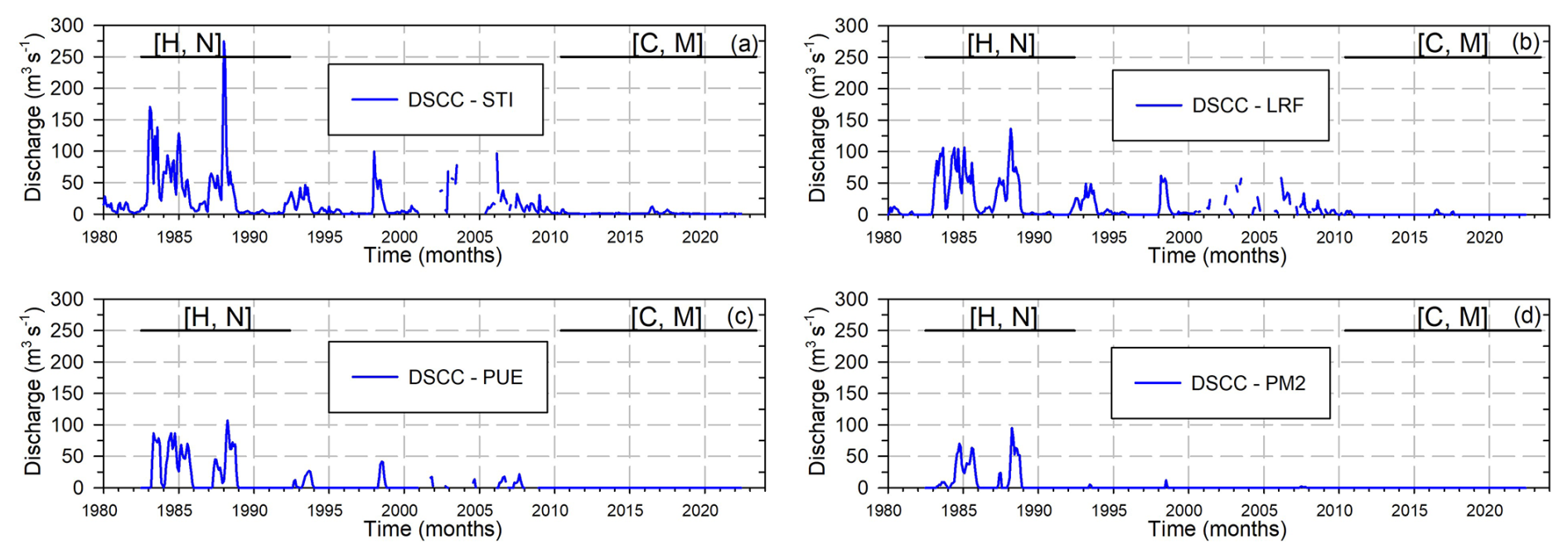
Figure 10Chronological monthly flows in the lower part of the Desaguadero–Salado–Chadileuvú–Curacó (DSCC) River basin with high-impoundment conditions. Straight lines indicate the historical (H) period (1982–1992) in assumed natural (N) regime and the current (C) period (2010–2023) with modified (M) regime. (a) DSCC River at Santa Isabel (STI), (b) DSCC River at La Reforma (LRF), (c) DSCC River at Puelches (PUE), and (d) DSCC River at Pichi Mahuida 2 (PM2).
Table 8 and Fig. 11 compare the two periods and indicate the values of the impact factors of the HRI in different gauging stations of the lower basin of the DSCC River. For the historical period, flows in STI exhibited a rather complex annual hydrograph with maximum flows in the summer season. This is the result of the prolonged travel time of allochthonous flows caused by the extensive river network relative to its headwaters (>1000 km) along with both anthropogenic (in upstream reservoirs) and natural (in LG and BT wetlands) flow regulation. In contrast, current conditions have an almost uniform hydrograph that demonstrates a drastic flow attenuation (MIF = 0.032). The predominance of winter flows resulted in a TIF = 0.084, whereas the intermittence of flows culminated in a non-natural interannual variability that led to a VIF = 0. Consequently, the resulting HRI = 0.003 indicates a drastic impact with a maximal modification of the flow regimen.
Downstream, the natural flows in LRF showed the combined effect of flow attenuation given by the regulation of the BA wetland and the contribution of the AT River. This regulation resulted also in a complex hydrograph with summer and winter flows being slightly more uniform than those observed in STI. However, for the current conditions, intermittent conditions with very attenuated winter flows were observed. The MIF = 0.013, TIF = 0.167, and VIF = 0 indicate the attenuation of the flows and their intermittency and winter occurrence. These impact factors resulted in an HRI = 0.002, showing a drastic impact on the hydrological regime.
As can be observed in both PUE and PM2 gauging stations, the annual hydrograph of the historical period showed a high predominance of winter flows given by the natural flow regulation of the LP wetland. On the contrary, no flows were observed for the current conditions along the 13 years considered. In consequence, all the impact factors and the resulting HRI values equalled 0, indicating a drastic impact on the hydrological regime in both gauging stations.
Table 8Hydrological regime index (HRI) for modified flows in the Desaguadero–Salado–Chadileuvú–Curacó (DSCC) River with high-impoundment conditions. Qma: mean annual flow. H: historical period (1982–1992), N: natural flows, C: current period (2010–2023), M: modified flows. MIF: magnitude impact factor, TIF: timing impact factor, and VIF: variation impact factor. DSCC River at Santa Isabel (STI), La Reforma (LRF), Puelches (PUE), and Pichi Mahuida 2 (PM2).

Figure 11Hydrological regime index (HRI) of the lower basin of the Desaguadero–Salado-Chadileuvú–Curacó (DSCC) River with high-impoundment conditions. Annual and scaled hydrographs for the historical (H) period (1982–1992) with natural flows (N) and current (C) period (2010–2023) with modified (M) flows. MIF: magnitude impact factor, TIF: timing impact factor, and VIF: variation impact factor. (a–b) DSCC River at Santa Isabel (STI) (H, N) versus (C, M), (c–d) DSCC River at La Reforma (LRF) (H, N) versus (C, M), DSCC River at Puelches (PUE) (H, N) versus (C, M), and DSCC River at Pichi Mahuida 2 (PM2) (H, N) versus (C, M).
The hydrological river regime is a spatial and temporally integrated basin response; therefore, a comprehensive approach should be used to assess the impacts due to both anthropogenic interventions, such as river regulation and water diversion for different uses, and changes in climate conditions.
As described, there are several point measurements of change in the flow regime. They are usually based on simple characteristics or statistics of the river flow hydrograph, such as mean, maximum, and minimum flow values; CV; and flow frequency for a given percentage of time, whereas flow variation is usually addressed by establishing ratios between some of these parameters or by the average flow in a given season. These metrics do not necessarily represent the flow distribution over the hydrological or water year in different conditions. Indeed, during extended periods of flow intermittency, some statistics are not applicable (e.g. CV cannot be mathematically solved, and the FDC is a straight line of zero flow). Additionally, both the magnitude timing parameters, such as means of the annual maxima or minima, and the magnitude frequency parameters such as the number of high or low pulses or their duration, remain the same. Similarly, the parameters that assess the frequency rate of change, including means of all positive or negative differences between consecutive daily means or the number of rises or falls remain unchanged.
Furthermore, the occurrence of unnatural variability (e.g. contributions of temporally lagged drainage from irrigated areas) may not necessarily be captured by seasonal averages or be assumed as natural unless compared with the upstream flow when a local or point evaluation index is used. The fact that many metrics relay on local measurements limits the study of temporal and spatial hydrological variability, such as the analysis of hydrological connectivity that is typically diminished or lost in semi-arid basins under conditions of drastic flow alteration.
The proposed HRI is a single and dimensionless metric that considers the impacts on the flow magnitude (i.e. flow attenuation), the timing of maximum flow (i.e. peak flow occurrence), and annual flow variation (i.e. the temporal pattern of flow variability), which is the more general definition of the hydrological regimen. Therefore, monthly mean flows are used to evaluate the different impact factors by comparing them across locations or throughout time. This method allows for its application in large basins, where daily flow variations do not necessarily represent the river–aquifer interaction, the activation of a wetland, or the maintenance of ecosystem functions downstream of the reservoirs. Additionally, this approach allows for addressing the usual lack of daily flow data, especially during no-flow periods, a condition that complicates the identification of pulses or the determination of runoff resumption.
Conceptually, the HRI is similar to the index proposed by Torabi Haghighi and Køble (2013) and Torabi Haghighi et al. (2014); however, a simpler approach is used to compute the river regime indices. HRI does not use conceptual hydrographs and somehow complex functions to represent the monthly river regime. Instead, the differences between the natural or reference regime and a uniform regime representing full regulation or no-flow conditions are calculated.
The HRI, due to its low data requirements and the identification of impact factors through the contrast between upstream and downstream flows, demonstrated its effectiveness as an indicator to discriminate both the spatial and temporal impacts on the hydrological regime in the DSCC and CO rivers in both continuous and discontinuous flow conditions and different degrees of regulation or impoundment conditions. For natural regimes, the synchronous comparison of flows between upstream and downstream gauging stations in the tributaries of the DSCC River demonstrated a responsiveness to minimal or no attenuation of flows, minimal time lag of the maximum flow, and diminished loss of interannual variability of the HRI, indicating incipient or extremely low impacts on the hydrological regime. In the case of the AT River, the incipient modification resulted from the streamflow losses in the alluvial fan at Las Juntas along with the significant distance (>100 km) separating the gauging stations. Aside from the applicability or the approximation employed to determine HRI for flows in a natural regime, it is verified that HRI can be a useful management tool to assess impacts caused by changes in land and water use.
This approach was validated in the CO River with higher flows. In its tributaries, the natural flow inputs of the GD and BR rivers did not show a modification downstream in BRQ in neither the flow attenuation nor the timing or the flow variability. The resulting HRI indicated an extremely low impact on the hydrological regime. Similarly, on its main channel between BRQ and PMA, the impact on the hydrological regime was classified as low even though both gauging stations are located 550 km apart, and there was water allocation for consumption and irrigation.
The HRI applied to low-impoundment conditions exhibited in the SJ River its sensitivity to varying hydrological conditions. When extreme flows occurred, presumably associated with an ENSO episode, such as those in 1941/42, flows exceeded the capacity of the water diversion dam; however, the initial damming determined that the impact on the hydrological regime downstream was high. On the contrary, with average natural flows, the impact observed downstream of the diversion dam was drastic. This showed that the operation of these hydraulic structures played an important role as well, mainly due to the high seasonal demands given by the low efficiency of gravity-fed irrigation systems.
For high-impoundment conditions, the HRI adequately discriminated between the reduced or no flow observed downstream of the reservoirs. The HRI values for the historical periods indicated severe and drastic impacts in all the tributaries except the DT River with a high impact. On average, the MIF value for all the tributaries equalled 0.228, and the most significant effects were the regime inversion and the loss of interannual variability, with TIF and VIF values equal to zero. This indicates that the runoff observed immediately downstream of the irrigation areas is not natural runoff but rather comes from irrigation drains. Towards the downstream,the modification of the hydrological regime worsens, and flow becomes more intermittent until runoff disappears.
For the current conditions characterized by lower natural flows and considering that the reservoir capacity did not change, except in the SJ River, a degradation of HRI values was observed in all tributaries. Although these values could be attributed to climate change that resulted in lower flows, the HRI impact factors demonstrated that water management for irrigation is the main cause of the drastic alteration of the snow-fed flow regimen observed in the tributaries. The MIF impact factor resulted in values that were either close to or below 50 % of those obtained in the historical series as a result of the reservoir operation for irrigation purposes with a total diversion of water stored during the crop growing season and water storage the rest of the time. The effects of hydropower management that may influence the frequency and duration of flow pulses, as well as the rate and frequency of changes in the flow, cannot be properly assessed because the flow downstream of the irrigation areas is not natural but rather comes from drainages or occasional water releases. This resulted in values of TIF and VIF equal to 0 or lower than the historical series. The exception is CAR in the AT River with the same VIF values, which, due to its location immediately downstream of the irrigation area, has already shown unnatural variability in the historical series.
In the DSCC River, the lack of flow determined that the HRI values were equal to zero, indicating a drastic impact in all the gauging stations. MIF shows decreasing values downstream, reaching zero in PUE and PM2, which indicates a loss of hydrological connectivity. TIF exhibits the same pattern, transitioning from winter flows at the nearest gauging stations to the irrigation areas to zero at the farthest downstream area. VIF is equal to zero, reflecting no variability attributed to groundwater discharge to baseflow or absence of runoff.
In the CO River, lower natural flows also resulted in a degradation of the HRI, indicating a moderate effect compared to the incipient impact seen in the historical period. Variations in natural runoff also showed an earlier occurrence of peak flows due to both a reduced duration of the snow accumulation period and a rapid ablation of snow. Consequently, downstream of the CDP reservoir, similar values of attenuation and intra-annual variability were observed, along with a slight increase in the temporal lag of the maximum monthly flows.
From a basic visual examination, it is obvious that the absolute lack of runoff indicates a drastic modification of the hydrological regime in the DSCC River that would not require the use of hydrological metrics. Nevertheless, the HRI allows us to both quantify the degree and discriminate the type of impact on the natural hydrological regime even when there are prolonged periods with no-flow conditions. As an illustration of these capabilities, Fig. 12 details the contrasting hydrological expressions of the DSCC River between the current and the fully activated river network (1988), where the HRI was applied. The surface of water obtained with the modified normalized difference water index (MNDWI) (McFeeters, 1996) using Landsat 4 and 5 images from September to December 1988 and Landsat 8 images for the hydrological year 2021/22 demonstrates that in 1988 (i.e. natural flows), there was a distinctly defined longitudinal and transversal hydrological connectivity throughout the alluvial flood plain. It is observed that all the tributaries contributed to the DSCC River except the VB River, which due to its low discharge values and intermittent flows was not identified by the MNDWI. The DSCC River exhibited activation across all sections and wetlands. Owing to the limited availability of satellite imagery and the sporadic runoff observed in the Curacó River in September of 1988 (see Fig. 10), the MNDWI was unable to recognize the intermittent runoff registered in the Curacó River that flowed into the CO River.
In comparison, the current spatial extent of the fluvial system of the DSCC River indicates that merely the natural flows in the tributaries located upstream of the reservoirs were recognized by the MNDWI. Therefore, no flows were detected downstream of the irrigation zones apart from the altered and intermittent flows in sections of the SJ, DT, and AT rivers and groundwater discharge from the alluvial fans of the tributaries along its first sections (DSCC-I or Río Chadileuvú and DSCC-II or Río Salado).
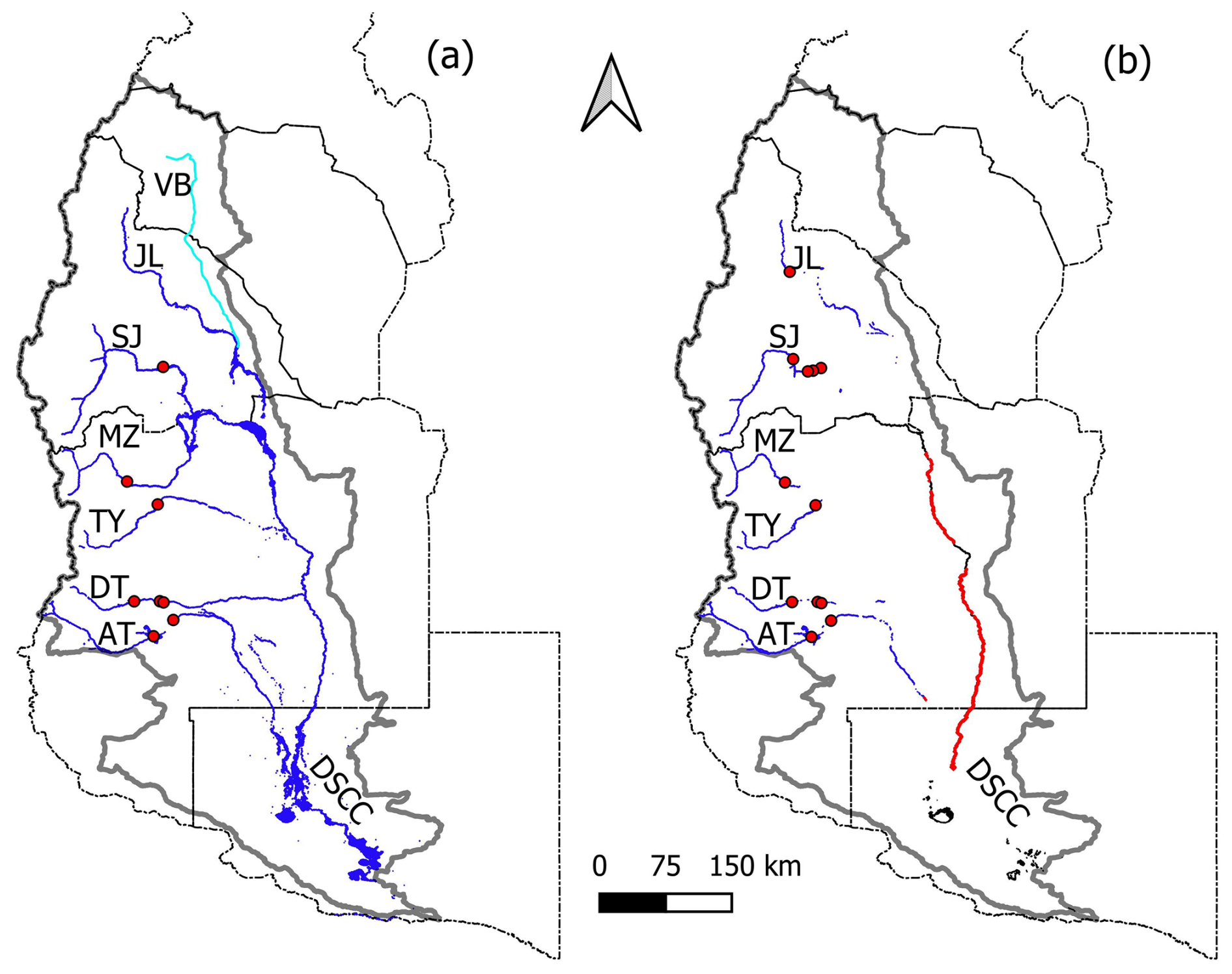
Figure 12Comparison of contrasting hydrological expressions of the Desaguadero–Salado–Chadileuvú–Curacó (DSCC) fluvial system obtained with the modified normalized difference water index (MNDWI) using the following optical Landsat satellite imagery (USGS, 2024b) row and path: 229-86 and 87, 230-83 to 86, 231-82 to 84, and 232-80 to 84, where the hydrological regime index (HRI) was applied. (a) Maximum areal extension in 1988. Blue lines indicate the connectivity between tributaries (JL, SJ, MZ, TY, DT, and AT rivers) and the DSCC River with all the wetlands activated, and the light-blue line indicates the VB River, but due to either low flows, intermittent runoff, or a lack of available images, the MNDWI did not identify it. (b) Current expression of the drainage network corresponding to 2021/22. Blue lines indicate tributaries only active upstream of the main reservoirs. Red lines indicate water in the DSCC River in its first sections (DSCC-I or Río Chadileuvú and DSCC-II or Río Salado), a product of groundwater discharge (<1 m3 s−1) of alluvial fans. No active wetlands are observed. Red dots represent main reservoirs.
In this context, the HRI based on temporal or spatial monthly flow comparisons overcomes the limitations of hydrologic alteration metrics as the majority of the parameters cannot be determined in the absence of runoff. Therefore, it constitutes an essential tool for defining e-flows and for assessing the effectiveness of both structural and non-structural management measures that might be adopted to restore the environmental degradation of the fluvial ecosystems of the DSCC River. Moreover, remote sensing data could serve as an indicator of the impact factors of the HRI as flow attenuation, the timing of occurrence of the maximum flow, and the interannual variability can be directly or indirectly evaluated through the analysis of the expansion or contraction of the fluvial system over time.
Climate change is another critical factor of regime modification whose effects can be evaluated with the HRI. The current period has exhibited reduced runoff due to diminished snowfall in the basin, and predictions for the study area indicate a decrease in snowfall alongside an increase in rainfall. However, according to Arheimer et al. (2017), the anthropogenic influence on the snow-fed hydrological regime of the DSCC River has been found to be detrimental in relation to the potential consequences of climate change on the input function of the basin. Therefore, for sustainable freshwater management, the proposed HRI will contribute to focus on the adaptation to climate change and other environmental stressors (Poff and Matthews, 2013), such as the lack of integrated water resources management in the basin.
An index, the HRI, is presented to evaluate the modifications in the hydrological regime of non-permanent rivers. The usually drastic alterations in flow observed in rivers of semi-arid regions, where runoff can alter between permanent- and intermittent-flow conditions, require a new approach to properly evaluate the modification of the hydrological regime in these basins, which we typically have limited information on. The HRI constitutes an aggregate impact index that facilitates its application in either spatial or temporal analysis. It can be applied at different points along the drainage network and is based on the comparison of monthly flow measurements upstream and downstream of the specified locations, while the comparison of different time series makes it suitable to evaluate variations in impoundment conditions, changes in land use, or effects of climate change.
The HRI evaluates three impacts on the hydrological regime: the attenuation of the flows, the time lag, and the change in the intra-annual variability. The utilization of monthly data enhances its applicability in areas with limited information regarding other indices that rely on daily data.
The HRI was suitable for evaluating drastic flow alterations in the DSCC River under both permanent and non-permanent flow conditions across all the tributaries and in its main channel. Its application identified that, in addition to the impoundment conditions, the operation of the reservoirs constitutes one of the main modifying factors of the hydrological regime within the basin. Additionally, the application of the HRI in the CO River under natural and modified flow conditions while maintaining permanent runoff validated the method and showed the ability of the HRI to compare impacts between different hydrological conditions.
The performance of the HRI in the DSCC River basin, characterized by the defined lack of hydrological connectivity between the upper basin, in which the hydrological processes governing the generation of snowmelt runoff in the mountainous area are not related to those in the lower basin, where evaporative processes prevail, indicates that it is a valuable tool for e-flow definition and environmental impact assessment.
All raw data are accessible in the indicated digital databases (https://bdh.lapampa.gob.ar: BDH, 2024; https://www.coirco.gov.ar: COIRCO, 2024; https://snih.hidricosargentina.gob.ar: SNIH, 2024; https://earthexplorer.usgs.gov/: USGS, 2024a, b), or they can be provided by the corresponding authors upon request.
PFD: conceptualization, data curation, formal analysis, investigation, methodology, validation, visualization, writing (original draft preparation), and writing (review and editing). RNC: data curation, visualization, and writing (review and editing).
The contact author has declared that neither of the authors has any competing interests.
Publisher's note: Copernicus Publications remains neutral with regard to jurisdictional claims made in the text, published maps, institutional affiliations, or any other geographical representation in this paper. While Copernicus Publications makes every effort to include appropriate place names, the final responsibility lies with the authors.
The authors wish to thank the Secretaría de Recursos Hídricos and the Secretaría de Ambiente de La Pampa, Argentina, for providing information regarding the lower basin of the DSCC River. We also thank the editor and two anonymous reviewers for their helpful critique, which improved the quality of the manuscript.
The research presented in this paper was conducted as part of the RN-50 project, funded by Facultad de Ciencias Exactas y Naturales de la Universidad Nacional de La Pampa.
This paper was edited by Hongkai Gao and reviewed by two anonymous referees.
Aceituno, P. and Vidal, F.: Variabilidad interanual en el caudal de ríos andinos en Chile central en relación con la temperatura superficial del mar en el Pacífico ecuatorial central, Revista de la SOCHID, 5, 7–19, 1990.
Amoros, C. and Bornette, G.: Connectivity and biocomplexity in waterbodies of riverine floodplains, Freshw. Biol., 47, 761–776, 2002.
Araneo, D. C. and Compagnucci, R. H.: Atmospheric circulation features associated to Argentinean Andean rivers discharge variability, Geophys. Res. Lett., 35, 1–6, https://doi.org/10.1029/2007GL032427, 2008.
Araneo, D. C. and Villalba, R.: Variability in the annual cycle of the Río Atuel streamflows and its relationship with tropospheric circulation, Int. J. Climatol., 35, 2948–2967, https://doi.org/10.1002/joc.4185, 2014.
Arheimer, B., Donnelly, C., and Lindström, G.: Regulation of snow-fed rivers affects flow regimes more than climate change, Nat Commun., 8, 1–9, https://doi.org/10.1038/s41467-017-00092-8, 2017.
Arthington, A. H.: Environmental Flows: Saving Rivers in the Third Millennium, vol. 4, Univ of California Press, ISBN 9780520953451, https://doi.org/10.1525/california/9780520273696.001.0001, 2012.
Arthington, A. H.: Environmental Flows: Ecological Effects of Hydrologic Alterations, Assessment Methods for Rivers, Challenges and Global Uptake, in: Encyclopedia of Inland Waters, edited by: Mehner, T. and Tockner, K., 2nd. edn., 2, 561–575, https://doi.org/10.1016/B978-0-12-819166-8.00089-X, 2022.
Barros, V. R., Doyle, M. E., and Camilloni, I. A.: Precipitation trends in southeastern South America: relationship with ENSO phases and with low-level circulation, Theor. Appl. Climatol., 93, 19–33, https://doi.org/10.1007/s00704-007-0329-x, 2008.
BDH: Hydrological database of La Pampa province, Secretaría de Recursos Hídricos de La Pampa [data set], https://bdh.lapampa.gob.ar (last access: 8 July 2024), 2024.
Best, J.: Anthropogenic stresses on the world's big rivers, Nat. Geosci., 12, 7–21, https://doi.org/10.1038/s41561-018-0262-x, 2019.
Bereciartua, P. J., Antunez, N., Manzelli, L., López, P., and Callau Poduje, A. C.: Estudio Integral de La Cuenca Del Río Desaguadero-Salado-Chadileuvú-Curacó. Universidad de Buenos Aires, Facultad de Ingeniería, Buenos Aires, vol. I, 178 pp., 2009.
Boulton, A. J., Rolls, R. J., Jaeger, K. L., and Datry, T.: Hydrological Connectivity in Intermittent Rivers and Ephemeral Streams, in: Intermittent Rivers and Ephemeral Streams, Ecology and Management, edited by: Datry, T., Bonada, N., and Boulton, A., Academic Press Elsevier, London, 79–108, https://doi.org/10.1016/b978-0-12-803835-2.00004-8, 2017.
Bruniard, E. D.: Aspectos geográficos de las precipitaciones nivales en la República Argentina, Boletín de Estudios Geográficos, 82–83, 7–30, https://bdigital.uncu.edu.ar/10890 (last access: 27 October 2024), 1986.
Callow, J. N. and Smettem, K. R. J.: The effect of farm dams and constructed banks on hydrologic connectivity and runoff estimation in agricultural landscapes, Environ. Model. Softw., 24, 959–968, https://doi.org/10.1016/j.envsoft.2009.02.003, 2009.
Chiesa, J. O., Ojeda, G. E., and Font, E. A.: Geología de las cuencas de Desaguadero y Bebedero, Latin American J. Sedimentology and Basin Analysis, 22, 47–77, 2015.
COIRCO: Colorado River Basin Interjurisdictional Committee [data set], https://www.coirco.gov.ar (last access: 26 September 2024), 2024.
Compagnucci, R. and Araneo, D.: Alcances de El Niño como predictor del caudal de los ríos andinos argentinos, Ingeniería Hidráulica en México, 22, 23–35, 2007.
Compagnucci, R. H. and Vargas, W.: Interannual variability of Cuyo Rivers streamflow in Argentinean Andean Mountains and ENSO events, Int. J. Climatol., 18, 1593–1609, https://doi.org/10.1002/(SICI)1097-0088(19981130)18:14<1593::AID-JOC327>3.0.CO;2-U, 1998.
Cortés, G., Vargas, X., and McPhee, J.: Climatic sensitivity of streamflow timing in the extratropical western Andes Cordillera, J. Hydrol., 405, 93–109, https://doi.org/10.1016/j.jhydrol.2011.05.013, 2011.
Datry, T., Larned, S. T., and Tockner, K.: Intermittent rivers: a challenge for freshwater ecology. Bioscience, 64, 229–235, https://doi.org/10.1093/biosci/bit027, 2014.
De Girolamo, A. M., Drouiche, A., Ricci, G. F., Parete, G., Gentile, F., and Debieche, T. H.: Characterising flow regimes in a semi-arid region with limited data availability: the Nil Wadi case study (Algeria), J. Hydrol. Reg. Stud., 41, 101062, https://doi.org/10.1016/j.ejrh.2022.101062, 2022.
Doering, M., Uehlinger, U., Rotach, A., Schlaepfer, D. R., and Tockner, K.: Ecosystem expansion and contraction dynamics along a large Alpine alluvial corridor (Tagliamento River, Northeast Italy), Earth Surf. Process. Landf., 32, 1693–1704. https://doi.org/10.1002/esp.1594, 2007.
Döll, P. and Schmied, H. M.: How is the impact of climate change on river flow regimes related to the impact on mean annual runoff? A global-scale analysis, Environ. Res. Lett., 7, 014037, https://doi.org/10.1088/1748-9326/7/1/014037, 2012.
Dornes, P. F., Antonena, S. V., Minig, A., Comas, R. N., Schulz, C. J., and Mariño, E. E.: Relación entre regímenes de escurrimiento superficiales y subterráneos en los humedales de los ríos Atuel y Salado, La Pampa, in: Relación Agua Subterránea-Superficial, edited by: García, R., Rocha, V., and Dornes, P., Científica Universitaria, Catamarca, 221–228, ISBN 978-987-661-225-8, 2016.
Gao, Y., Vogel, R. M., Kroll, C. N., Poff, N. L., and Olden, J. D.: Development of representative indicators of hydrologic alteration, J. Hydrol, 374, 136–147, https://doi.org/10.1016/j.jhydrol.2009.06.009, 2009.
Gómez-Navarro, O., De Girolamo, A. M., Lorenz, A. W., Khadhar, S., Debieche, T.-H., Gentile, F., Chiron, S., and Pérez, S.: Characterization of anthropogenic impacts in Mediterranean intermittent rivers with chemical, ecological and hydrological indicators, J. Hazard. Mater., 480, 135951, https://doi.org/10.1016/j.jhazmat.2024.135951, 2024.
Gordon, N. D., McMahon, T. A., Finlayson, B. L., Gippel, C. J., and Nathan, R. J. (Eds.): Stream Hydrology: An Introduction for Ecologists. Wiley, Chichester, England, 429, ISBN 0-470-84357-8 (HB), 2004.
Harman, C. and Stewardson, M.: Optimizing dam release rules to meet environmental flow targets, River Res. Appl., 21, 113–129, 2005.
Lauro, C., Vich, A. I. J., and Moreiras, S. M.: Streamflow variability and its relationship with climate indices in western rivers of Argentina, Hydrol. Sc. J., 64, 607–619, https://doi.org/10.1080/02626667.2019.1594820, 2019.
Leone, M., Gentile, F., Lo Porto, A., Ricci, G. F., and De Girolamo, A.M.: Ecological flow in southern Europe: Status and trends in non-perennial rivers, J. Environ. Manage., 342, 118097, https://doi.org/10.1016/j.jenvman.2023.118097, 2023.
Li, D., Wang, W., and Zaho, J.: Optimizing environmental flow operations based on explicit quantification of IHA parameters, J. Hydrol., 563, 510–522, 2018.
Llop, A., Fasciolo, G., Duek, A., Comellas, E., and Buccheri, M.: El balance hídrico en las cuencas de Mendoza: aportes para su medición, En Revista Proyección, 14, 48–67, 2013.
Magilligan, F. J. and Nislow, K. H.: Changes in hydrologic regime by dams, Geomorph., 71, 61–78, https://doi.org/10.1016/j.geomorph.2004.08.017, 2005.
Magilligan, F. J., Nislow, K. H., and Renshaw, C. E.: Flow regulation by dams, in: Treatise on Geomorphology. Fluvial Geomorphology, edited by: Schroeder, J. Academic Press, San Diego, CA, 794–808 pp., ISBN 9780123747396, 2013.
Masiokas, M. H., Villalba, R., Luckman, B. H., Le Quesne, C., and Aravena, J. C.: Snowpack variations in the central Andes of Argentina and Chile, 1951–2005: large-scale atmospheric influences and implications for water resources in the Region, J. Climate, 19, 6334-6352, 2006.
Masseroni, D., Ricart, S., De Cartagena, F. R., Monserrat, J., Gonçalves, J. M., De Lima, I., Facchi, A., Sali, G., and Gandolfi, C.: Prospects for improving gravity-fed surface irrigation systems in Mediterranean European contexts, Water 9, 20, https://doi.org/10.3390/w9010020, 2017.
McFeeters, S. K.: The use of normalized difference water index (NDWI) in the delineation of open water features, Int. J. Remote Sens., 17, 1425–1432, 1996.
McMahon, T. J. and Finlayson, B. H.: Droughts and anti-droughts: the low flow hydrology of Australian rivers, Freshw. Biol., 48, 1147–1160, 2003.
McManamay, R. A., George, R., Morrison, R. R., and Ruddell, B. L.: Mapping hydrologic alteration and ecological consequences in stream reaches of the conterminous United States, Sci Data, 9, 450, https://doi.org/10.1038/s41597-022-01566-1, 2022.
Montecinos, A. and Aceituno, P.: Seasonality of the ENSO related rainfall variability in central Chile and associated atmospheric circulation, J. Climate, 16, 281–296, 2003.
Olden, J. D. and Poff, N. L.: Redundancy and the choice of hydrologic indices for characterizing streamflow regimes, River Res. Appl., 19, 101–121, 2003.
Páez Campos, H. R. and Dornes, P. F.: Expresión espacio-temporal del sistema de humedales de los ríos Atuel y Salado, La Pampa, Argentina, Boletín Geológico y Minero, 132, 37–45, https://doi.org/10.21701/bolgeomin.132.1-2.004, 2021.
Penalba, O. C. and Rivera, J. A.: Precipitation response to El Niño/La Niña events in Southern South America – emphasis in regional drought occurrences, Adv. Geosci., 42, 1–14, https://doi.org/10.5194/adgeo-42-1-2016, 2016.
Poff, N. L. and Matthews, J. H.: Environmental flows in the Anthropocene: past progress and future prospects, Current Opinion in Environmental Sustainability, 5, 667–675, https://doi.org/10.1016/j.cosust.2013.11.006, 2013.
Poff, N. L. and Zimmerman, J. K. H.: Ecological Responses to Altered Flow Regimes: A Literature Review to Inform the Science and Management of Environmental Flows, Freshwater Biol., 55, 194–205, https://doi.org/10.1111/j.1365-2427.2009.02272.x, 2010.
Poff, N. L., Allan, J. D., Bain, M. B., Karr, J. R., Prestegaard, K. L., Richter, B. D., Sparks, R. E., and Stromberg, J. C.: The natural flow regime, Bioscience, 47, 769–784, https://doi.org/10.2307/1313099, 1997.
Poff, N. L., Olden, J. D., Merritt, D. M., and Pepin, D. M.: Homogenization of regional river dynamics by dams and global biodiversity implications, P. Natl. Acad. Sci. USA, 104, 5732–5737, https://doi.org/10.1073/pnas.0609812104, 2007.
Prieto, M. R., Herrera, H. G., Dussel, P., Gimeno, L., and Ribera, P.: Interanual oscillations and trend of snow occurrence in the Andes region since 1885, Aust. Meteorol. Mag., 50, 164–168, 2001.
Prohaska, F.: The climate of Argentina, Paraguay and Uruguay, in: World Survey of Climatology, edited by Schwerdtfeger W., Elsevier, Amsterdam, 12, 13–112, 1976.
Radinger, J., Alcaraz-Hernández, J. D., and García-Berthou, E.: Environmental and spatial correlates of hydrologic alteration in a large Mediterranean river catchment, Sci. Total Environ., 639, 1138–1147, https://doi.org/10.1016/j.scitotenv.2018.05.227, 2018.
Ramos, V.: Las provincias geológicas del territorio argentino, in: Geología Argentina, edited by: Caminos, R., Intituto d Geología y Recursos Naturales, Anales, 29, 41–96, 1999.
Richter, B. D., Baumgartner, J. V., Braun, D. P., and Powell, J. A.: Spatial assessment of hydrologic alteration within a river network, Regul. Rivers: Res. Mgmt, 14, 329–340, https://doi.org/10.1002/(SICI)1099-1646(199807/08)14:4<329::AID-RRR505>3.0.CO;2-E, 1998.
Richter, B. D., Baumgartner, J. V., Powell, J., and Braun, D. P.: A method for assessing hydrologic alteration within ecosystems, Conserv. Biol., 10, 1163–1174, https://doi.org/10.1046/j.1523-1739.1996.10041163.x, 1996.
Richter, B. D., Baumgartner, J. V., Wigington, B., and Braun, D.: How much water does a river need?, Freshw. Biol., 37, 231–249, https://doi.org/10.1046/j.1365-2427.1997.00153.x, 1997.
Richter, B. D., Davis, M. M., Apse, C., and Konrad, C.: A presumptive standard for environmental flow protection, River Res. Appl., 28, 1312–1321, https://doi.org/10.1002/rra.1511, 2012.
Rivera, J. A., Araneo, D. C., and Penalba, O. C.: Threshold level approach for streamflow droughts analysis in the Central Andes of Argentina: a climatological assessment, Hydrol. Sc. J., 62, 1949–1964, https://doi.org/10.1080/02626667.2017.1367095, 2017.
Sauquet, E., Shanafield, M., Hammond, J. C., Sefton, C., Leigh, C., and Datry, T.: Classification and trends in intermittent river flow regimes in Australia, northwestern Europe and USA: A global perspective, J. Hydrol., 597, 126170, https://doi.org/10.1016/j.jhydrol.2021.126170, 2021.
Stanley, E. H., Fisher, S. G., and Grimm, N. B.: Ecosystem Expansion and Contraction in Streams, Bioscience., 47, 427–435, 1997.
Singh, R. K. and Jain, M. K.: Reappraisal of hydrologic alterations in the Roanoke River basin using extended data and improved RVA method, Int. J. Environ. Sci. Technol., 18, 417–440, 2020.
SNIH: National hydrological information system, Subsecretaría de Recursos Hídricos de Argentina [data set], https://snih.hidricosargentina.gob.ar (last access: 17 September 2024), 2024.
Steward, A. L., von Schiller, D., Tockner, K., Marshall, J. C., and Bunn, S. E.: When the river runs dry: human and ecological values of dry riverbeds, Front. Ecol. Environ., 10, 202–209, https://doi.org/10.1890/110136, 2012.
Torabi Haghighi, A. and Køble, B.: Development of a general river regime index (RRI) for intra-annual flow variation based on the unit river concept and flow variation endpoints, J. Hydrol., 503, 169–177, 2013.
Torabi Haghighi, A., Marttila, H., and Køble, B.: Development of a new index to assess river regime impacts after dam construction, Glob. Planet. Change, 122, 186–196, https://doi.org/10.1016/j.gloplacha.2014.08.019, 2014.
Tramblay, Y., Rutkowska, A., Sauquet, E., Sefton, C., Laaha, G., Osuch, M., Albuquerque, T., Alves, M. H., Banasik, K., Beaufort, A., Brocca, L., Camici, S., Csabai, Z., Dakhlaoui, H., De Girolamo, A. M., Dörflinger, G., Gallart, F., Gauster, T., Hanich, L., Kohnová, S., Mediero, L., Plamen, N., Parry, S., Quintana-Seguí, P., Tzoraki, O., and Datry, T.: Trends in flow intermittence for European rivers, Hydrol. Sci. J., 66, 37–49, https://doi.org/10.1080/02626667.2020.1849708, 2021.
USGS: United States Geological Survey [data set], https://earthexplorer.usgs.gov/ (last access: 1 April 2024), 2024a.
USGS: United States Geological Survey [data set], https://earthexplorer.usgs.gov/ (last access: 7 October 2024), 2024b.
Viviroli, D. and Weingartner, R.: The hydrological significance of mountains: from regional to global scale, Hydrol. Earth Syst. Sci., 8, 1017–1030, https://doi.org/10.5194/hess-8-1017-2004, 2004.
Vogel, R. M., Sieber, J., Archfield, S. A., Smith, M. P., Apse, C. D., and Huber-Lee, A.: Relations among storage, yield, and instream flow, Water Resour. Res., 43, W05403, https://doi.org/10.1029/2006WR005226, 2007.
Wang, H., Brill, E. D., Ranjithan, R. S., and Sankarasubramanian, A.: A framework for incorporating ecological releases in a single reservoir operation, Adv. Water Resour., 78, 9–21, 2015.
Wang, X., Ma, W., Lv, J., Li, H., Liu, H., Mu, G., and Bian, D.: Analysis of changes in the hydrological regime in Lalin River basin and its impact on the ecological environment, Front. Earth Sci., 10, 2022, https://doi.org/10.3389/feart.2022.987296, 2022.
Waylen, P. R. and Caviedes, C. N.: Annual and seasonal fluctuations of precipitation and streamflow in the Aconcagua River basin, Chile, J. Hydrol., 120, 79–102, https://doi.org/10.1016/0022-1694(90)90143-L, 1990.
Wineland, S. M., Başağaoğlu, H., Fleming, J., Friedman, J., Garza-Diaz, L., Kellogg, W., Koch, J., Lane, B. A., Mirchi, A., Nava, L. F., Neeson, T.M., Ortiz-Partida, J. P., Paladino, S., Plassin, S., Gomez-Quiroga, G., Siaz-Rodriguez, R., Sandoval-Solis, S., Wagner, K., Weber, N., Winterle, J., and Wootten, A. M.: The environmental flows implementation challenge: Insights and recommendations across water-limited systems, WIREs Water, 2022, e1565, https://doi.org/10.1002/wat2.1565, 2021.
Zhou, X., Huang, X., Zhao, H., and Ma, K.: Development of a revised method for indicators of hydrologic alteration for analyzing the cumulative impacts of cascading reservoirs on flow regime, Hydrol. Earth Syst. Sci., 24, 4091–4107, https://doi.org/10.5194/hess-24-4091-2020, 2020.